Embed Size (px)
Citation preview

How Landsat Helps: WATER
Annual rainfall along Idaho’s Snake River Plain is as low as 10 inches (2.5 centimeters) per year, or less, isn’t enough to support crops in the region. Credit: p.m. graham on flickr.com

How Landsat Helps: WATER
25 Landsat
Mapping Water Use | Holli Riebeek and Laura Rocchio
Dean Stevenson has farmed the plains of south-central Idaho most of his forty-seven years. Like all farmers, he worries about things like the price of sugar beets and malt barley or the cost of gasoline, but most of all, he worries about water.
He is right to worry. The 4,000 acres he farms with his father and brother receive on average a scant 10 inches of rain per year. The water that sustains the sugar beets, barley, wheat, and potatoes growing on Stevenson land is pumped from the Snake River Plain aquifer. Every drop is rationed.
In 2006, the staff of another irrigation district on the Snake River Plain, A&B, believed that some of its farms had run short on water, resulting in a poor harvest. Because A&B has senior (older) water rights, Idaho law allowed the irrigation district staff to issue a water call, a demand that junior water right holders, including Stevenson, draw less water from the aquifer.
The agency with the unenviable task of sorting out water calls is the Idaho Department of Water Resources. The agency keeps track of how much water is in the state’s rivers and ground water to ensure that Idaho has a viable water supply for all of its users—farmers, cities and towns, and natural ecosystems.
State water agencies across the western United States face similar challenges. “Chronic water supply problems in
many areas of the West are among the greatest challenges we face in the coming decades.” Mark Limbaugh, the U.S. }
Photo Information
Above: Pivot irrigation
gives these Colorado
fields a circular shape.
Credit: USDA.
Below: Many western
farmers rely on irrigation.
Credit: Robert Burns, USDA
26 Landsat
Department of the Interior’s (DOI) former Assistant Secretary for Water and Science, told U.S. Senators in 2006.
The challenge in refereeing water disputes, or managing a water supply in general, has always been figuring out how much water is actually being used. Most of us think of ‘water use’ as the water we are billed for every month. But for state water managers, ‘water use’ has a different meaning. They consider water to be used when it evaporates from the ground or is soaked up by growing plants and released (transpired) as water vapor through openings (stomata) found on the undersides of leaves.
A water meter, such as those on the wells that Dean Stevenson uses to pump irrigation water from the Snake River Plain aquifer, tracks how much water a user withdraws, but not how much is actually consumed or used. To track farmers’ water use, the Department of Water Resources needs to measure evapotranspiration (evaporation plus transpiration) across millions of acres of cropland—a nearly insurmountable task. Idaho uses more water than any other U.S. state except California and Texas, and more than 90 percent of the water consumed in Idaho goes to irrigate 3.4 million acres of farmland, providing the economic base for the state.
Enter Landsat “Remote sensing was the only way to throw a rope around all the water consumption going on in Idaho,” says Rick Allen, a water resources engineer at the University of Idaho. With a grant from NASA in 2000, Allen and Tony Morse, the Department of Water Resources geospatial technology manager (recently retired) began looking for ways to use data from the Landsat satellites to estimate evapotranspiration (ET) across the Snake River Plain and other farmland in Idaho.
Detailed water consumption maps can be made quickly and easily with Landsat because of its 30 m spatial resolution and thermal imaging capability. Landsat has been proclaimed “the best and least expensive way to quantify and locate where water is used and in what quantity,” by Morse and Allen.
The Landsat-based estimates of water use come from a model called METRIC, for “Mapping Evapotranspiration at high Resolution with Internalized Calibration.” By 2003 METRIC was beginning to run as an operational model at the Idaho Department of Water Resources.
The Landsat satellites have a number of characteristics that make them well suited for water-use mapping:
(1) The spatial resolution of Landsat enables water managers to map water use for individual agricultural fields and thereby manage on a field-by-field basis. With coarser-resolution data this doesn’t work. Landsat’s resolution “helps us to resolve water consumption on the scales of anthropogenic interaction and land and water ownership,” Allen explains.
(2) Landsat’s spectral coverage includes a thermal infrared band. This thermal information is essential for water-use mapping because the mapping process is predicated on the fundamental principle that evaporating water consumes energy, i.e. the more water fields are losing through ET, the cooler they are.
(3) There is now an archive containing more than a quarter of a century worth of global Landsat data that has the spatial resolution, spectral coverage, and thermal imagery needed for water-use mapping. “Landsat provides continuity to assess change in ET over time and to document historical water consumption,” Allen says—an essential capability in the U.S. West, where water rights often are established by historical precedence.
(4) The Landsat satellites’ orbit place them overhead during morning hours, avoiding common afternoon cloud cover. }
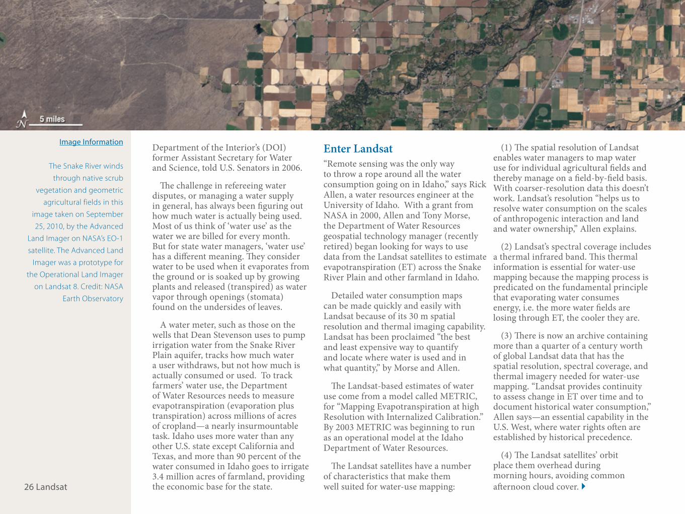
Image Information
The Snake River winds
through native scrub
vegetation and geometric
agricultural fields in this
image taken on September
25, 2010, by the Advanced
Land Imager on NASA’s EO-1
satellite. The Advanced Land
Imager was a prototype for
the Operational Land Imager
on Landsat 8. Credit: NASA
Earth Observatory

27 Landsat
(5) The entire Landsat archive is publicly available at no cost. As Morse highlights, “all parties to a water dispute have equal access to a primary data source.”
The METRIC Model Prior to using METRIC, the Idaho Department of Water Resources estimated evapotranspiration for each county from temperature, humidity, wind speeds, and sunlight measured at regional weather stations coupled with thousands of less-than-dependable water meters. For the eastern Snake River Plain in Idaho, this type of traditional monitoring cost the state half a million dollars per year. In comparison, the same monitoring done with Landsat data is $80,000. When looking at the western states together, Morse has estimated a potential ten-year savings as high as $1 billion.
When the A&B water call came in to the Department of Water Resources, Morse and Bill Kramber, a remote sensing analyst, had just started to analyze water use throughout the state during 2006.
To determine if farmers in the A&B district had been damaged by water shortages, all Kramber and his colleagues had to do was compare water use, which they got from evapotranspiration determined by METRIC, to vegetation }
Incoming sunlight either heats the ground and the overlying air, or it drives evapotranspiration—the evaporation of water from the ground or the leaves of plants. Scientists infer water loss from the amount of energy being consumed by evapotranspiration. (Corn Image ©2010 Noam Armonn. Used under license from Shutterstock.com. Diagram by Robert Simmon, NASA’s Earth Observatory.)
Photo Information
Above: Irrigated farms in
southern Idaho use water
from both the Snake River
and the Snake River Plain
aquifer. Credit: j o s h on
flickr.com
How Landsat Helps: WATER

28 Landsat
growth, which can also be assessed using Landsat data. They compared these measurements for the A&B district to those of surrounding farms that relied on both ground water and surface water.
“It just didn’t look like the area was any different than the surrounding areas. If it had been short of water, it should have shown a lower evapotranspiration rate,” says Kramber.
The director of the Idaho Department of Water Resources decided there simply wasn’t enough evidence that A&B farmers had suffered substantially as a result of water shortages. Their fields seemed to be as productive as anyone else’s. The director denied the water call, deciding not to curtail Stevenson and other ground water irrigators in his district. A&B appealed the decision, bringing METRIC into the Idaho court system.
Improving Water Use With his water rights upheld for now, Stevenson sees applications for METRIC outside the courtroom. He sees it as a tool that could save money by helping him assess how much water he is actually using. It costs money to pump water from the aquifer, and he wants to pump only what he actually needs. “Water is a finite resource, and whatever we can do to try to maximize and optimize the use of that resource is a good }
Vegetation, Temperature and Evapotranspiration
Scientists use Landsat measurements of infrared and visible light reflected from vegetation (top) to determine how much plants are growing and how hot the surface temperature is. In this infrared and visible image, crops are various shades of green, while bare or sparsely vegetation ground is pink. Such measurements are used to calculate evapotranspiration rates and to estimate water use (below). The most heavily vegetated areas are usually cool because the energy from sunlight goes into converting liquid water to water vapor, instead of heating.
Photo Information
Above: Instrument stations
measure evapotranspiration
and atmospheric moisture
for a single location.
Landsat provides a less
detailed, but broader
perspective. Credit USDA
Evapotranspiration (mm/day)
0 4.5 9

29 Landsat
thing for us. Whatever we can do to get better information on what [water] we use, we as producers will benefit from that,” he says.
A large number of winners are western water managers, who now have an efficient way to monitor and manage water consumption. In the dry Western states, irrigated agriculture accounts for 86% of all water consumption, and the water-use information provided by METRIC is critical for arbitrating increasingly common water-resource conflicts. As agricultural irrigation needs, swelling city populations, and a changing climate increase demand for scarce water supplies, water management strategy is shifting from increasing water supply to innovatively managing water use at sustainable levels. Accurate water-use mapping is essential for effective water management, and the Landsat-based method can be as much as 30 percent more accurate than traditional measurement methods.
In the decade since Idaho introduced METRIC, users in many thirsty Western states have adopted it. These states include California, Colorado, Montana, Nebraska, Nevada, New Mexico, Oregon, Texas, Utah, and Wyoming. The mapping method has enabled water managers in these states to negotiate Native American water rights; }
The Idaho Department of Water Resources used Landsat evapotranspiration data to determine that
crops in A&B had been getting about the same amount of water as surrounding crops. This Landsat-7
image shows the region on August 1, 2001, with water district boundaries from the Idaho Department
of Water Resources. Credit: NASA Earth Observatory.
Photo Information
Above: Monitoring
agricultural water use ensures
that water resources are
available for other uses,
including recreation. Credit:
woodley wonderworks on
flickr.com
How Landsat Helps: WATER

“Remote sensing was the only way to throw a rope around all the water consumption going on in Idaho.” —Rick Allen
A mustard crop grows in the hills near Moscow, Idaho. Credit: Bob Nichols, USDA

31 Landsat
assess urban water transfers; manage aquifer depletion, monitor water right compliance; and protect endangered species.
Learn More:NASA Earth Observatory’s Water Watchershttp://earthobservatory.nasa.gov/Fea-tures/WaterWatchers/
Precious Resources: Water & Landsat’s Thermal Band http://landsat.gsfc.nasa.gov/?p=299
Landsat-based Water Use Mapping Method Hailed as an Important American Government Innovation http://landsat.gsfc.nasa.gov/?p=730 g
Meet Rick Allen, Professor of Water Resources at University of Idaho
Rick AllenProfessor of Water ResourcesUniversity of IdahoMoscow, Idaho
One way or the other, I’ve almost always worked. I toiled on my father’s farm from 6 am to 7:30 am each day before school and again from 4 pm to 8 pm each night, and Saturdays and some Sundays. I fed pigs and cattle, shoveled manure, ran machinery in corn and soybean fields, and pulled weeds. But I knew I had to leave the family farm because I wanted to explore.
I got an Agricultural Engineering degree from Iowa State University, where several professors shared with me their passion and skills for bringing technology to people. They
taught me how to develop creative, practical ideas and to put them boldly into practice to help solve problems for others. At that time I also discovered more of nature, an abiding love for riding motorcycles, and good books.
I continued to follow the allure and intrigue of learning, increasing my understanding of physics and the physical world and my ability to develop tools to quantify and manage it. I got a MS and then a Ph.D degree. Famines in Africa continually caught my attention, and I felt compelled to join the battle to meet people¹s resource and food needs. So I did some work in developing countries teaching irrigation and research technology.
Now I am a Professor of Water Resources Engineering at the University of Idaho, a member of the Landsat Science Team, and a consulting engineer. I visualize solutions to technical problems, and then to solve them I develop new mathematical relationships and computer programming codes. For fun sometimes I fire up my 1961 International 560 diesel tractor just to hear the motor cackle. I drag race semitrailers on my Harley motorcycle too. I give them a one-eighth-mile head start at 60 mph in a three-eights-mile race. I love winning but it’s the race itself that I love most!
Satellite DataRequirements:
q16-day revisit
. 30 m resolution
R Vis, NIR, SWIR, TIR
/ Global spatial coverage
P archive continuity &
consistency
Qrapid delivery of free,
unrestricted data
Tgeolocation ≥ 15 m
@Calibration ≥ 5%
N 12-bit bit data digitization
How Landsat Helps: WATER