Embed Size (px)
Citation preview

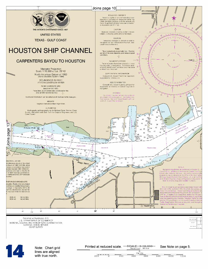
BookletChart™ Houston Ship Channel Carpenters Bayou to Houston NOAA Chart 11325
A reduced-scale NOAA nautical chart for small boaters When possible, use the full-size NOAA chart for navigation.
Included Area

2
Published by the National Oceanic and Atmospheric Administration
National Ocean Service Office of Coast Survey
www.NauticalCharts.NOAA.gov 888-990-NOAA
What are Nautical Charts?
Nautical charts are a fundamental tool of marine navigation. They show water depths, obstructions, buoys, other aids to navigation, and much more. The information is shown in a way that promotes safe and efficient navigation. Chart carriage is mandatory on the commercial ships that carry America’s commerce. They are also used on every Navy and Coast Guard ship, fishing and passenger vessels, and are widely carried by recreational boaters.
What is a BookletChart?
This BookletChart is made to help recreational boaters locate themselves on the water. It has been reduced in scale for convenience, but otherwise contains all the information of the full-scale nautical chart. The bar scales have also been reduced, and are accurate when used to measure distances in this BookletChart. See the Note at the bottom of page 5 for the reduction in scale applied to this chart.
Whenever possible, use the official, full scale NOAA nautical chart for navigation. Nautical chart sales agents are listed on the Internet at http://www.NauticalCharts.NOAA.gov.
This BookletChart does NOT fulfill chart carriage requirements for regulated commercial vessels under Titles 33 and 44 of the Code of Federal Regulations.
Notice to Mariners Correction Status
This BookletChart has been updated for chart corrections published in the U.S. Coast Guard Local Notice to Mariners, the National Geospatial Intelligence Agency Weekly Notice to Mariners, and, where applicable, the Canadian Coast Guard Notice to Mariners. Additional chart corrections have been made by NOAA in advance of their publication in a Notice to Mariners. The last Notices to Mariners applied to this chart are listed in the Note at the bottom of page 7. Coast Pilot excerpts are not being corrected.
For latest Coast Pilot excerpt visit the Office of Coast Survey website at http://www.nauticalcharts.noaa.gov/nsd/searchbychart.php?chart=11325
[Selected Excerpts from Coast Pilot] Houston Ship Channel extends from Galveston Harbor across Galveston Bay and through parts of San Jacinto River and Buffalo Bayou to the city of Houston, a distance of 44 miles. The entrance to the channel is at the NW end of Bolivar Roads, between Port Bolivar and Texas City channels. The entrance is marked by a 318° lighted range and by a lighted bell buoy on the NE side of the channel. The channel through the bay is marked by
lights, lighted ranges, buoys, daybeacons, and a leading light at Baytown Bend.
N of Bolivar Peninsula, spoil banks on both sides of the channel extend N to Red Fish Bar. About 1.5 miles below Red Fish Bar, a narrow channel marked at the entrance by Daybeacon 1, exits Houston Ship Channel to the W, leading to Dickinson Bayou. In 1985, the controlling depth through the spoil bank was 6 feet. In 2009, it was reported that Dickson Channel Daybeacon 1 was not visble. Along the NE side of Houston Ship Channel N of Red Fish Bar, there are several dredged openings through the spoil bank permit passage into the NE part Upper Galveston Bay; see that chart for depths. An oil-loading terminal is at Mile 333.2W on the SE side of the waterway. The waterway continues SW to Port Bolivar and Galveston Bay. Basins along this part of the waterway have several marinas where berths, gasoline, diesel fuel, water, ice, launching ramps, and marine supplies can be obtained. A marina at Mile 342.9W, on the SE side of the waterway can accommodate craft drawing up to 5 feet, and has facilities for handling craft up to 55 feet for hull and engine repairs. A channel leading from Galveston Bay through Sievers Cove to the waterway, about Mile 343.2W, is marked on both sides by piles. The waterway leaves the Bolivar cut and enters Galveston Bay at Mile 349.3W. The direct route bypasses Galveston and proceeds SW through the lower part of the bay. Houston Ship Channel is crossed at Mile 350.2W. The Coast Guard has requested vessels transiting the waterway make a SECURITE call on VHF-FM channel 13 prior to crossing Houston Ship Channel, particularly during periods of restricted visibility. Vessel Traffic Service Houston-Galveston recommends west bound tows avoid meeting east bound tows between Bolivar Peninsula Buoy 15 and Buoy 20 due to strong currents and shoaling at the entrance to Bolivar. The port of Houston is 43 miles to the NW. The channel to Texas City is crossed at Mile 350.8W; the port is 5 miles to the WNW. There is a dry storage marina on the end of the Texas City Dike, about 0.6 mile NW of the junction with Texas City Channel. Gasoline, diesel fuel, water, ice, and marine supplies are available. A depth of 6 feet was reported alongside the fuel dock and in the approach channel in August 1982. The Coast Guard advises vessels exercise particular caution where the channel intersects the Intracoastal Waterway, about 6.6 miles above the entrance jetties and just below Lighted Buoys 25 and 26. Situations resulting in collisions, groundings, and close quarters passing have been reported by both shallow and deep draft vessels. The Coast Guard has requested vessels make a SECURITE call on VHF FM channel 13 prior to crossing the Intracoastal Waterway, particularly during periods of restricted visibility. Coast Guard.–A Sector Office is in Houston. (See Appendix A for address.) Houston Coast Guard Air Station is at Ellington Air Force Base. Harbor regulations.–The Port of Houston is managed, governed, and controlled by the Port of Houston Authority. The regulations are enforced by the Director of the Port whose offices are in the Port Authority Building at 1519 Capital Avenue; telephone (713-225-0671). (See 162.75 (b)(4), chapter 2, for speed limit in the harbor.) Smoking is prohibited on any wharf except in designated smoking areas and is also prohibited on the open decks or in the hatches of any vessel in the harbor. These regulations are strictly enforced.
U.S. Coast Guard Rescue Coordination Center 24 hour Regional Contact for Emergencies
RCC New Orleans Commander
8th CG District (504) 589-6225 New Orleans, LA

G
Lateral System As Seen Entering From Seaward on navigable waters except Western Rivers
PORT SIDE ODD NUMBERED AIDS
GREEN LIGHT ONLY FLASHING (2)
PREFERRED CHANNEL NO NUMBERS – MAY BE LETTERED
PREFERRED CHANNEL TO STARBOARD
TOPMOST BAND GREEN
PREFERRED CHANNEL NO NUMBERS – MAY BE LETTERED
PREFERRED CHANNEL TO PORT
TOPMOST BAND RED
STARBOARD SIDE EVEN NUMBERED AIDS
RED LIGHT ONLY FLASHING (2)
FLASHING FLASHING OCCULTING GREEN LIGHT ONLY RED LIGHT ONLY OCCULTING QUICK FLASHING QUICK FLASHING ISO COMPOSITE GROUP FLASHING (2+1) COMPOSITE GROUP FLASHING (2+1) ISO
"1"
Fl G 6s
G "9"
Fl G 4s
GR "A"
Fl (2+1) G 6s
RG "B"
Fl (2+1) R 6s
"2"
Fl R 6s
8
R "8" Fl R 4s
LIGHT
G
C "1"
LIGHTED BUOY
G "5"
GR "U"
GR
C "S"
RG
N "C"
RG "G"
LIGHT
6
R
N "6"
LIGHTED BUOY
R
"2"
CAN DAYBEACON
CAN NUN NUN
DAYBEACON
For more information on aids to navigation, including those on Western Rivers, please consult the latest USCG Light List for your area. These volumes are available online at http://www.navcen.uscg.gov
2
2
C U 5
1


VHF Marine Radio channels for use on the waterways:Channel 6 – Inter-ship safety communications.Channel 9 – Communications between boats and ship-to-coast.Channel 13 – Navigation purposes at bridges, locks, and harbors.Channel 16 – Emergency, distress and safety calls to Coast Guard and others, and to initiate calls to other
vessels. Contact the other vessel, agree to another channel, and then switch.Channel 22A – Calls between the Coast Guard and the public. Severe weather warnings, hazards to navigation and safety warnings are broadcast here.Channels 68, 69, 71, 72 and 78A – Recreational boat channels.
Getting and Giving Help — Signal other boaters using visual distress signals (flares, orange flag, lights, arm signals); whistles; horns; and on your VHF radio. You are required by law to help boaters in trouble. Respond to distress signals, but do not endanger yourself.
EMERGENCY INFORMATION
Distress Call Procedures
• Make sure radio is on.• Select Channel 16.• Press/Hold the transmit button.• Clearly say: “MAYDAY, MAYDAY, MAYDAY.”• Also give: Vessel Name and/or Description;Position and/or Location; Nature of Emergency; Number of People on Board.• Release transmit button.• Wait for 10 seconds — If no responseRepeat MAYDAY call.
HAVE ALL PERSONS PUT ON LIFE JACKETS!
This Booklet chart has been designed for duplex printing (printed on front and back of one sheet). If a duplex option is not available on your printer, you may print each sheet and arrange them back-to-back to allow for the proper layout when viewing.
QR
Quick ReferencesNautical chart related products and information - http://www.nauticalcharts.noaa.gov
Interactive chart catalog - http://www.charts.noaa.gov/InteractiveCatalog/nrnc.shtmlReport a chart discrepancy - http://ocsdata.ncd.noaa.gov/idrs/discrepancy.aspx
Chart and chart related inquiries and comments - http://ocsdata.ncd.noaa.gov/idrs/inquiry.aspx?frompage=ContactUs
Chart updates (LNM and NM corrections) - http://www.nauticalcharts.noaa.gov/mcd/updates/LNM_NM.html
Coast Pilot online - http://www.nauticalcharts.noaa.gov/nsd/cpdownload.htm
Tides and Currents - http://tidesandcurrents.noaa.gov
Marine Forecasts - http://www.nws.noaa.gov/om/marine/home.htm
National Data Buoy Center - http://www.ndbc.noaa.gov/
NowCoast web portal for coastal conditions - http://www.nowcoast.noaa.gov/
National Weather Service - http://www.weather.gov/
National Hurrican Center - http://www.nhc.noaa.gov/
Pacific Tsunami Warning Center - http://ptwc.weather.gov/
Contact Us - http://www.nauticalcharts.noaa.gov/staff/contact.htm
NOAA’s Office of Coast Survey The Nation’s Chartmaker
For the latest news from Coast Survey, follow @NOAAcharts
NOAA Weather Radio All Hazards (NWR) is a nationwide network of radio stations broadcasting continuous weather information directly from the nearest National Weather Service office. NWR broadcasts official Weather Service warnings, watches, forecasts and other hazard information 24 hours a day, 7 days a week. http://www.nws.noaa.gov/nwr/