Embed Size (px)
Citation preview

www.elsevier.com/locate/margeo
Marine Geology 209 (2004) 45–67
Holocene development of the Yellow River’s subaqueous delta,
North Yellow Sea
J. Paul Liua,*, John D. Millimanb, Shu Gaoc, Peng Chengd
aDepartment of Marine, Earth and Atmospheric Sciences, North Carolina State University, Raleigh, NC 27695, USAbSchool of Marine Science, College of William & Mary, VA 23062, USA
cDeptartment of Geo-Ocean Science, Nanjing University, Nanjing 210093, ChinadMarine Sciences Research Center, Stony Brook University, NY 11794, USA
Received 21 October 2002; received in revised form 7 June 2004; accepted 7 June 2004
Abstract
High-resolution seismic profiles from the North Yellow Sea reveal a 20–40-m-thick subaqueous clinoform delta that wraps
around the eastern end of the Shandong Peninsula, extending into the South Yellow Sea. This complex sigmoidal-oblique
clinoform, containing an estimated 400 km3 of sediment, overlies prominent relict transgressive surfaces. The nearshore topset
of the clinoform, < 30-m water depth, has a b1:1000 gradient, with high sedimentation rates (210Pb) f 6–12 mm/year.
Foreset beds (30–50 m) dip seaward at a steeper gradient (2:1000) and have sedimentation rates f 3 mm/year. Bottomset
strata, in water depths >50 m, contain less than 1 m of Holocene sediment, with low sedimentation rates, < 1 mm/year. In
contrast to other clinoforms, the Shandong clinoform appears to be a compound subaqueous deltaic system, with what we
interpret to be proximal and distal phases of clinoform development. The underlying proximal sequence formed proximally
between f 11 and 9.2 ka in response to a temporary pause in the rapid postglacial sea-level rise after the meltwater pulse 1B
(MWP-1B) and increased discharge from the Yellow River to the North Yellow Sea due to intensification of the summer
monsoon. A flooding surface appears to separate the proximal and distal phases, corresponding to the next rapid sea-level rise
9.5–9.2 ka BP (MWP-1C). Since 9.2 ka BP, an overlying distal sedimentary sequence has accumulated, reflecting the back-
stepping and shifting river mouth westward to the Gulf of Bohai. Some inputs from coastal erosion and nearby small streams
may be locally important. Along-shore transport, cross-shelf advection, and upwelling in the North Yellow Sea have reworked
post-LGM sediment and have helped maintain the morphology of the clinoform in the Shandong mud wedge.
D 2004 Elsevier B.V. All rights reserved.
Keywords: epicontinental sea; Yellow Sea; Yellow River; subaqueous delta; seismic; clinoform; sea level
1. Introduction
Rivers and their deltas serve as the primary path-
way for the transport of fresh water and terrigenous
0025-3227/$ - see front matter D 2004 Elsevier B.V. All rights reserved.
doi:10.1016/j.margeo.2004.06.009
* Corresponding author. Tel.: +1-919-515-7977.
E-mail addresses: [email protected] (J.P. Liu),
[email protected] (J.D. Milliman).
sediment to the coastal ocean (Milliman and Meade,
1983). The morphology of deltas, which constitute an
important component within stratigraphic sequences
in both modern and ancient continental margins
(Morgan, 1970), is largely controlled by the fluvial,
tidal, and wave regime (Wright and Coleman, 1973).
Equally prominent off many large river mouths are
subaqueous clinoforms, meters in height and tens of

J.P. Liu et al. / Marine Geology 209 (2004) 45–6746
kilometers in horizontal extent, characterized by rela-
tively flat topset beds, steeper foresets, and gradual
bottom sets. Modern examples include clinoforms off
the Amazon (Nittrouer et al., 1986), the Yellow River
(Huanghe) (Alexander et al., 1991), the Ganges–
Brahmaputra (G–B) (Kuehl et al., 1997), and the
Yangtze (Changjiang) (Chen et al., 2000) rivers.
As with other sedimentary features, clinoform
development and resultant geometry are dictated by
the complex interplay of sediment supply, deposition-
al environment, and the extent and rate of the rise/fall
of relative sea level. Kuehl et al. (1986) attributed the
low accumulation rates (< 1 mm/year) on the Amazon
clinoform topset (< 20-m water depth) to energetic
physical conditions. Decreased wave and tidal energy
on the thick foreset beds at 30–60-m water depth
results in higher rates of sediment accumulation, as
great as 100 mm/year. Accumulation in bottomset
(>70-m water depth) strata decreases in response to
reduced sediment supply. High-resolution seismic
profiles on the Bengal shelf also show highest accu-
mulation rates (z 50 mm/year) in the foreset region of
Fig. 1. Location and bathymetric map of the Bohai Sea (BS), North Yello
The Yellow Sea Warm Current (YSWC) and the Yellow Sea Coastal Cold
mud wedge and other mud patches in the YS and ECS. Water depth in m
the G–B subaqueous delta (30–60-m water depth)
and lowest (< 3 mm/year) in the bottomset (60–80-m
water depth) (Kuehl et al., 1997). A similar stratigra-
phy has been described for the Yangtze subaqueous
delta (Chen et al., 2000).
Many subaqueous clinoforms seem to overlie a
transgressive layer 60 m more below present-day sea
level. Beyond seaward limit of the Yangtze sub-
aqueous bottomset, at 60–70 m, for example, sedi-
ments are composed of grayish yellow, well-sorted
fine to medium–fine sands containing shallow-water
shells (Chen et al., 2000), representing relict sedi-
ments deposited during the last regression, low-stand
and subsequent transgression of sea level (Saito et al.,
1998). Thus, understanding of the geometry and
formation of subaqueous clinoforms requires not only
a knowledge of present-day environmental conditions,
but also of sea-level history.
The modern Yellow River, which presently dis-
charges into the western Bohai Sea (Fig. 1), is widely
recognized as having (together with the Amazon and
Ganges–Brahmaputra) the highest sediment load on
w Sea (NYS), South Yellow Sea (SYS), and East China Sea (ECS).
Current (YSCCC). Shaded areas represent location of the Shandong
eters.

J.P. Liu et al. / Marine Geology 209 (2004) 45–67 47
Earth, about 109 t/year (Qian and Dai, 1980; Milliman
and Syvitski, 1992). Highly turbid gravity flows
transport some sediment off the modern delta (Wright
et al., 1988, 1990), but most of the fluvially derived
sediment (>90%) appears to remain trapped within the
modern deltaic system (Bornhold et al., 1986, Martin
et al., 1993, Wright et al., 2001). In the 1980s, a
prominent mud wedge was noted extending south-
ward from the eastern tip of the Shandong Peninsula
(Milliman et al., 1987), some 350 km east of the
present-day river mouth. Alexander et al. (1991)
suggested that this Shandong Subaqueous Delta rep-
resents a direct escape route of Yellow River sediment
into the South Yellow Sea. More recent work has
shown that this clinoform also extends along the
northern side of the Shandong Peninsula in the North
Yellow Sea (Liu et al., 2002) (Fig. 1). In contrast to
Alexander et al. (1991), however, Liu et al. (2002)
have suggested that much of this thick mud wedge
was probably formed proximally to the paleo-Yellow
River mouth in the early Holocene. In this paper, we
discuss the high-resolution seismic structure and sedi-
mentary facies in the North Yellow Sea as well as
other sedimentological and oceanographic data, which
collectively allow us to synthesize the history of this
prominent clinoform.
Fig. 2. Seismic profile lines (j) and surface-sediment
2. Study area
2.1. Bathymetry
The Yellow Sea is a shallow, relatively flat, semi-
closed epicontinental sea bordered by China and the
Korean peninsula. To the northwest is the very shal-
low Bohai Sea, with water depths generally less than
40 m. To the south is the East China Sea (Fig. 1),
which borders the Okinawa Trough to the south. A
NW–SE trough, defined by the 80-m isobath (Fig. 1),
transects the eastern part of the Yellow Sea; else-
where, water depths are shallower. The Shandong
Peninsula separates the South from the North Yellow
Sea (NYS).
The NYS, the subject of this paper, is defined largely
by the 40- and 60-m isobaths. Most of the central
portion of the basin is deeper than 50 m and character-
ized by a relatively flat bottom (Figs. 2 and 3), although
large symmetrical bed forms occur in the northeast
adjacent to the Yalu River. The apparent symmetrical
configuration of these sand ridges suggests that they are
heavily influenced by tidal oscillations within the NYS
(Qin et al., 1989). Greatest depths in the NYS occur
between the Shandong Peninsula and Korea, where
depths locally exceed 70 m (Qin et al., 1989).
sample locations (.) in the North Yellow Sea.

Fig. 3. Three-dimensional seafloor morphology of the North Yellow Sea shows a series of subtle terraces around Shandong Peninsula. It also
shows the location of our seismic profiles (black lines) and box and gravity cores (red square boxes) in relation to the clinoform.
J.P. Liu et al. / Marine Geology 209 (2004) 45–6748
The three-dimensional bathymetric morphology
(Fig. 3) shows a prominent terrace that wraps around
the eastern Shandong Peninsula; we call this feature
Fig. 4. Transect surveys between C–D (eastern tip of Shandong Peninsula)
Shandong to Liaodong Peninsula) (Martin et al., 1993; Zhao, 1996), and E
(Martin et al., 1993).
the Shandong clinoform. Gradients in water depths
shallower than about 20–25 m areb1:1000, whereas
on the clinoform’s foresets gradients are 2:1000.
(Xia and Guo, 1983; Li and Ding, 1996), A–B (cross the NYS from
–F (across the Bohai strait from Shandong to Liaodong Peninsula)

J.P. Liu et al. / Marine Geology 209 (2004) 45–67 49
There are, however, several subtle breaks in clinoform
topography (Fig. 3). A 5–10-m linear depression is
seen in water depths shallower than about 25–40 m
(see Profile 99-E in Fig. 10), landward of which the
bottom shoals towards the peninsula. As will be
discussed later, we suspect that this shallow trough
may reflect erosion and eastward transport of clino-
form sediment. The other morphologic break occurs at
about 45 m in profiles 99-E and 99-F (Fig. 10) and
represents what we term the toe of the clinoform (see
below).
2.2. Regional oceanography
The general circulation in the North Yellow Sea is
characterized by a counterclockwise gyre, with north-
westward inflow of Yellow Sea Warm Current
(YSWC) in the winter along the eastern and northern
sides of the basin and the Yellow Sea Cold Coastal
Fig. 5. Vertical profiles of temperature and salinity (1989–1991) of the tr
mixed winter conditions (a, b), and stratified summer conditions (c, d) with
Current (YSCCC) flowing eastward from the Gulf of
Bohai along the Shandong Peninsula into South
Yellow Sea (Fig. 1). During the winter, strong north-
westerly winds drive surface and nearshore transport
southward, necessitating a northward return flow at
depth. The YSWC, reaching at most about 5 cm/s
(Yuan and Su, 1984), produces a warm tongue of
water that follows a path along the deepest axis in the
eastern SYS and northern NYS basins (Zheng and
Klemas, 1982). The YSWC also penetrates into Bohai
Sea and plays an important role in forming sand
ridges in the east Bohai Sea and dispersing the fine
sediments into the west side of the Gulf (Liu et al.,
1998).
Temperature and salinity profiles (A–B) across the
NYS (Figs. 4–6) based on published hydrographic
data indicate that the entire NYS can be well mixed
under the influence of strong northwesterly wintertime
winds, November (Fig. 5a) and February (Fig. 5b). At
ansect A–B (Fig. 4), which cross the whole NYS, reveal the well-
a cold and saltier water in the central bottom (Martin et al., 1993).

J.P. Liu et al. / Marine Geology 209 (2004) 45–6750
same time, a cold, fresh surface water flows eastward
out of the Bohai Sea into the NYS and SYS along the
north coast of Shandong Peninsula, and a relative
warmer, more saline subsurface counter-current flows
westward (Guan, 2000). Suspended sediment concen-
trations in the wintertime are highest in nearshore
regions (cross-section C–D), with values exceeding
50 mg/l (Fig. 6a).
The summertime hydrography across the NYS
(A–B) is characterized by a pronounced cold-pool
in the deeper basin overlain by 20–25 m of highly
stratified warmer water (Figs. 5c and d) (Martin et al.,
1993). Stratification breaks down along the bound-
aries of the NYS, reflecting in part counterclockwise
circulation in the NYS and landward upwelling (Zhao,
1996). A sustained cold surface water around eastern
tip of the Shandong Peninsula also suggests possible
upwelling (Xia and Guo, 1983). More stratified sum-
mertime conditions and calmer weather result in the
much lower suspended matter concentrations in NYS
coastal waters (i.e., C–D and E–F profiles), generally
Fig. 6. Vertical profiles of TSS distribution along the transect C–D (Li an
nearshore bottom in winter (a) and lower value in Summer (b–d). Transe
5–10 mg/l (Fig. 6b and d) (Li and Ding, 1996; Martin
et al., 1993). Recent (1995–1997) NOAA-AVHRR
satellite images show that high suspended matter
concentration in the coastal water of YS and ECS
move offshore from November to March, whereas
from May to September transport is onshore (Sun et
al., 2000). 3-D sediment transport models of the Bohai
Sea (Jiang et al., 2000) and Yellow Sea (Yanagi and
Inoue, 1995) indicate that although there is indeed
some eastward and southward transport of sediment in
the winter and early spring, most modern Yellow
River-derived sediment remains in the Bohai Sea.
2.3. The Yellow River
The most unique feature of the Yellow Sea is the
presence of the Yellow River, which currently dis-
charges into the Gulf of Bohai, but as recently as 1855
discharged south of the Shandong Peninsula along the
Jiangsu coast (Fig. 1). Draining arid northern China,
the river’s discharge historically has been low; its
d Ding, 1996) and E–F (Martin et al., 1993) reveal the higher TSS
ct shown in Fig. 4.

J.P. Liu et al. / Marine Geology 209 (2004) 45–67 51
large sediment loads come from the easily erodable
late Pleistocene loess along the middle reaches of the
river, as well as impacts of historically poor farming
techniques. Over the past 2000 years or so, the river
has discharged about 109 t/year of sediment, before
which its load may have been as much as an order of
magnitude lower (Milliman et al., 1987; Saito and
Yang, 1995, Saito et al., 2001). Recently, the river’s
annual load has dropped considerably in response to
improved land conservation, dam construction, and
increased water withdrawal due to decreased rainfall
(Yang et al., 1998; Galler, 1999).
Because of its historically large sediment load, the
Yellow River has meandered frequently, and as a
result its course has changed both regionally and
locally. In the past 9000 years, there have been 11
documented shifts in the Yellow River’s path, at least
twice when the river flowed south of the Shandong
Peninsula (Saito et al., 2001). Although the first such
episode is poorly documented, the river apparently
shifted to the south in response to heavy floods f 9
ka (Yang et al., 2000) and continued to discharge at
the Jiangsu coast for the next 2 ky (Liu et al., 2002).
For nearly 6-ky beginning about 7 ka, the river dis-
charged mostly or entirely into the Bohai Sea, before
shifting southward again in 1128 AD. The river then
again shifted to the north in 1855, where it has
prograded the present Yellow River delta nearly 50
km (Saito et al., 2001).
Since sea level reached (or exceeded) its present-
day position about 7.5 ka, sediment has accumulated
in coastal areas along the Jiangsu coast and on
present-day Yellow River delta in the western Bohai.
Before that, during the post-LGM sea-level transgres-
sion (11–7.5 ka), it accumulated in the SYS and NYS,
in response to varying rates of sea-level rise (Liu,
2001) and reinitiation of the SW Monsoon, 11 ka.
During this 3.5-ky period, a prominent subaqueous
delta formed off the Jiangsu coast in the SYS,
presumably the result of the first south-shift of the
Yellow River in the early Holocene (9.0–7.0 ka) (Liu
et al., 2002). We submit and attempt to prove in this
paper that the Shandong mud wedge, abutting the
eastern and northern edges of the Shandong Peninsu-
la, is also a relict feature of the Yellow River, formed
in response to increased sediment discharge from a
strengthened SW (summer) monsoon and a relative
still-stand during post-LGM sea-level transgression.
3. Methods
Since the early 1980s, many oceanographic and
geological/geophysical cruises have documented the
oceanography, morphology, surface sediments, and
shallow stratigraphy of the Yellow Sea. Seismic
profiles obtained in 1983–1989 as part of a cooper-
ative study between the Institute of Oceanology,
Chinese Academy of Sciences (IOCAS), and the
Woods Hole Oceanographic Institution (WHOI)
helped define the configuration and boundaries of
the Shandong clinoform in the South Yellow Sea
(Figs. 1 and 2) (Milliman et al., 1989). The distribu-
tion and configuration of the clinoform in the Bohai
and North Yellow seas described in this paper were
defined by geophysical and geological data obtained
during two cruises in 1998 and 1999 aboard the RV
Gold Star II of IOCAS. During these two cruises, we
collected approximately 1200 km of high-resolution
seismic profiles, 10 gravity cores (four are cited in this
study), 70 surface sediment samples (Fig. 2), and 7
box cores (Fig. 3). All seismic data were obtained
with a 450-kJ ORE GeoPulse boomer system fired at
0.5-s intervals; records were filtered between 500 and
3000 Hz.
Well-documented peat deposits that underlie the
mud wedge in the North Yellow Sea were sampled in
the gravity cores (NYS-5) (Fig. 10) and AMS-dated at
WHOI’s NOSAMS lab. Radiocarbon ages were cal-
culated using 5568 years as the half-life of radiocar-
bon and are reported in calendar years using the newly
updated CALIB4.3 (Stuiver et al., 1998).210Pb activities were determined from sediments
sampled at 2-cm intervals from seven box cores (Fig.
3) to determine short-term rates of sediment accumu-
lation. Sediments were dried, ground, homogenized,
and packed in 50-mm diameter petri dishes. After
waiting at least 20 days for secular equilibrium of226Ra daughter isotopes, the samples were counted for
1–3 days by gamma spectrometry, planar germanium
detector coupled to a multichannel analyzer. Activities
were corrected for shelf-absorption using a radioiso-
tope source (Cutshall et al., 1983). Excess 210Pb
activities were calculated by subtracting the supported
levels obtained from parent 226Ra activities.
Grain size of the surface sediments was measured
after first wet-sieving the samples through a 63-Amsieve. Sand fractions retained on the sieve were dried

J.P. Liu et al. / Marine Geology 209 (2004) 45–6752
and sieved. Mud fractions passing through the sieve
were pretreated using a dispersing agent (sodium
hexametaphosphate) to inhibit flocculation, and then
dispersed and homogenized using ultrasound before
passing through the Cilas Laser Particle Size Analyzer
(model: 940L). Size parameters were calculated based
on the methods of McManus (1988).
Oceanographic data (temperature, salinity, current,
and total suspended particulate matter) are from
historical observations conducted in the NYS between
1959 and 1993 (Xia and Guo, 1983; Milliman et al.,
1986; Martin et al., 1993; Li and Ding, 1996; Zhao,
1996) (Fig. 4).
4. Results
4.1. Shallow structure
GeoPulse profiles (Figs. 7–13) show a prominent
clinoform, 15–40 m in thickness, that thins offshore
to less than 1 m. It abuts the northern slope of the
Fig. 7. GeoPulse records from profiles 99-A and 83-a in the east tip of the S
ravinement surface in the east. Profile locations are shown in Figs. 2 and
Shandong Peninsula, and wraps around the eastern
end of the Peninsula, connecting with the Shandong
subaqueous delta (Alexander et al., 1991) that extends
into the South Yellow Sea. The clinoform is underlain
by a highly reflective surface that locally is acousti-
cally opaque (Figs 7, 9–11, 13) and that lies at or near
the seafloor in the central parts of the NYS. Core
NYS-5 (Fig. 10) penetrated a dark peat at 120 cm,
which AMS 14C dating (calibrated age: 11.8 ky BP)
suggests was deposited presumably subaerially when
post-LGM sea-level had not yet transgressed into the
NYS.
A compact yellow layer, which we interpret to be
loess, was recovered at 230 cm in Core S45 (Figs. 12
and 15). We assume that this loess is synchronous
with loess exposed along the present-day northern
coast of the Shandong Peninsula, and was deposited
by the intensified winter monsoon during LGM (Liu
and Zhao, 1995). Other cores penetrated stiff clay or
silty-sand layers that we assume were deposited
subaerially during or before the post-LGM transgres-
sion (Kim et al., 1999, Park et al., 1998). Where
handong Peninsula showing clinoform in the west, and transgressive,
3.
Fig. 8. High-resolution GeoPulse records of the westernmost part of the seismic profile 99-A, show a clinoform structure with the oblique
features in the west. The transgressive system tract (TST) culminating with a maximum flooding surface (msf) is seen underlying the later mud
deposits. The early-phase bottomset can be seen to be buried by the later foreset deposits. Location of profile is shown in Figs. 2 and 3.
J.P. Liu et al. / Marine Geology 209 (2004) 45–67 53
modern muds have been winnowed by strong erosion
(e.g., northern end of profile 99-C, near the deep
channel in the Bohai Strait; Figs. 11 and 12), these
stiff clays lie sufficiently near the seafloor to be
sampled with a grab. We therefore conclude that this
acoustically reflective surface represents a combina-
tion of low-stand stiff silts and clays, and post-LGM
peaty deposits.
Locally, subparallel semitransparent layers are seen
to lie beneath the acoustic reflective surface (Figs. 8–
10), truncated by a prominent erosional surface (pro-
file 99-B in Fig. 9). Some profiles show this layer to be
filled with acoustically reflective strata, suggesting a
transgressive systems tract (TST) (Figs. 8–10), while
to the east this surface appears to outcrop at the
seafloor (Fig. 7). Perhaps the best evidence of the
nature and age of transgressive surface is seen in
Profile 99-C, where strong currents near the Bohai
Strait have removed the acoustically opaque post-
LGM strata, exposing the morphologically uneven
ravinement surface (Fig. 11, top). Close inspection of
the seismic profiles (e.g., 99-E, Fig. 10; 83-a; Fig. 7)
shows several deeper reflective surfaces, which we
assume represent position of the former sea level
before last transgression.
In the NYS, the clinoform is thickest in the east
and thins to less than 15 m in the west (Profile 99-C;
Fig. 11); it apparently is poorly defined or nonexistent
in the Bohai Sea (Fig. 12). The shape of this clinoform
in the west (such as 99-C) shows a typical sigmoidal
structure, but most of others show oblique to complex
sigmoidal–oblique clinoform. Topset gradients are

Fig. 9. GeoPulse record of profile 99-B from the eastern NYS the western NYS in along the shoreshore of north Shandong Peninsula, which
shows the seaward and eastward progradation of the mud wedge. An enlargement of the clinoform’s toe and easternmost part is shown below.
Location of profile is shown in Figs. 2 and 3.
J.P. Liu et al. / Marine Geology 209 (2004) 45–6754
much less than 1/1000, whereas foreset gradients are
about 2/1000 (Fig. 3). Sediment volume within the
entire Shandong clinoform is roughly estimated to be
about 300 km3, of which about 200 km3 are in the
NYS (Liu et al., 2002).
Careful inspection of many of the clinoform pro-
files shows a rather complex inner structure, perhaps
best seen in Profiles 99-A, B, and F (Figs. 8–10). The
lower part of the clinoform lying under the topset and
foreset beds tends to be acoustically ‘‘turbid’’, and in
Profile 99-F this turbid layer conforms with a reflector
that lies about 7–8 m beneath the upper part of the
foreset and f 15 m beneath the lower foreset. The
turbid layer is seen on all other profiles except Profile
99-C, in the far west of the NYS. Judging from other
clinoforms (Nittrouer et al., 1996; Diaz et al., 1996),
this turbid layer presumably indicates the presence of
biogenic gas. Strata overlying the turbid layer, in
contrast, are acoustically transparent, locally to the
extent that individual reflectors are difficult to delin-
eate. A closer inspection of the profiles indicates that
the ‘‘toe’’ described above consists of younger pro-
grading strata (Figs. 9 and 10). Existence of the
biogenic gas and the distinct acoustic reflections/fea-
tures implicate different sediment composition and
depositional processes. The gas-discharged layer in
the lower part of the clinoform is apparently mainly
composed of silts to silt-sands, in contrast with the
clay-silt dominated upper layer (Fig. 15). The signif-
icance of this is discussed below.
4.2. Sediments and recent rates of sediment accumu-
lation (210Pb)
Surface sediments throughout the NYS are charac-
terized by medium to fine silts, with the finest sedi-
ment occurring near the Shandong Peninsula and in the
central part of the basin (Fig. 14); sand generally
constitutes less than 5–10% of the sediments. Inter-
rupting this pattern, however, are two tongues of
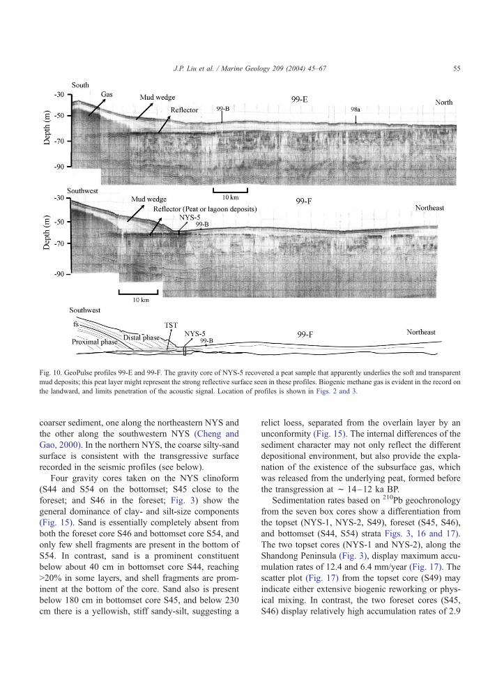
Fig. 10. GeoPulse profiles 99-E and 99-F. The gravity core of NYS-5 recovered a peat sample that apparently underlies the soft and transparent
mud deposits; this peat layer might represent the strong reflective surface seen in these profiles. Biogenic methane gas is evident in the record on
the landward, and limits penetration of the acoustic signal. Location of profiles is shown in Figs. 2 and 3.
J.P. Liu et al. / Marine Geology 209 (2004) 45–67 55
coarser sediment, one along the northeastern NYS and
the other along the southwestern NYS (Cheng and
Gao, 2000). In the northern NYS, the coarse silty-sand
surface is consistent with the transgressive surface
recorded in the seismic profiles (see below).
Four gravity cores taken on the NYS clinoform
(S44 and S54 on the bottomset; S45 close to the
foreset; and S46 in the foreset; Fig. 3) show the
general dominance of clay- and silt-size components
(Fig. 15). Sand is essentially completely absent from
both the foreset core S46 and bottomset core S54, and
only few shell fragments are present in the bottom of
S54. In contrast, sand is a prominent constituent
below about 40 cm in bottomset core S44, reaching
>20% in some layers, and shell fragments are prom-
inent at the bottom of the core. Sand also is present
below 180 cm in bottomset core S45, and below 230
cm there is a yellowish, stiff sandy-silt, suggesting a
relict loess, separated from the overlain layer by an
unconformity (Fig. 15). The internal differences of the
sediment character may not only reflect the different
depositional environment, but also provide the expla-
nation of the existence of the subsurface gas, which
was released from the underlying peat, formed before
the transgression at f 14–12 ka BP.
Sedimentation rates based on 210Pb geochronology
from the seven box cores show a differentiation from
the topset (NYS-1, NYS-2, S49), foreset (S45, S46),
and bottomset (S44, S54) strata Figs. 3, 16 and 17).
The two topset cores (NYS-1 and NYS-2), along the
Shandong Peninsula (Fig. 3), display maximum accu-
mulation rates of 12.4 and 6.4 mm/year (Fig. 17). The
scatter plot (Fig. 17) from the topset core (S49) may
indicate either extensive biogenic reworking or phys-
ical mixing. In contrast, the two foreset cores (S45,
S46) display relatively high accumulation rates of 2.9

Fig. 11. GeoPulse record of profile of 99-C in the west NYS and 99-D across the central NYS from south to north. 99-C does not display the
transparent character seen in other profiles, which indicate a coarser size fraction. Location of profiles is shown in Figs. 2 and 3.
Fig. 12. Gravity core of S45 reveals the apparent eolian loess deposits lying beneath ‘‘modern’’ muds (also see Fig. 15). This loess may reflect
the lowstand LGM depositional environment. Profile 98b indicates less than 10-m Holocene sediments in the eastern part of the NYS and the
Bohai Sea. Location of core is shown in Fig. 2.
J.P. Liu et al. / Marine Geology 209 (2004) 45–6756
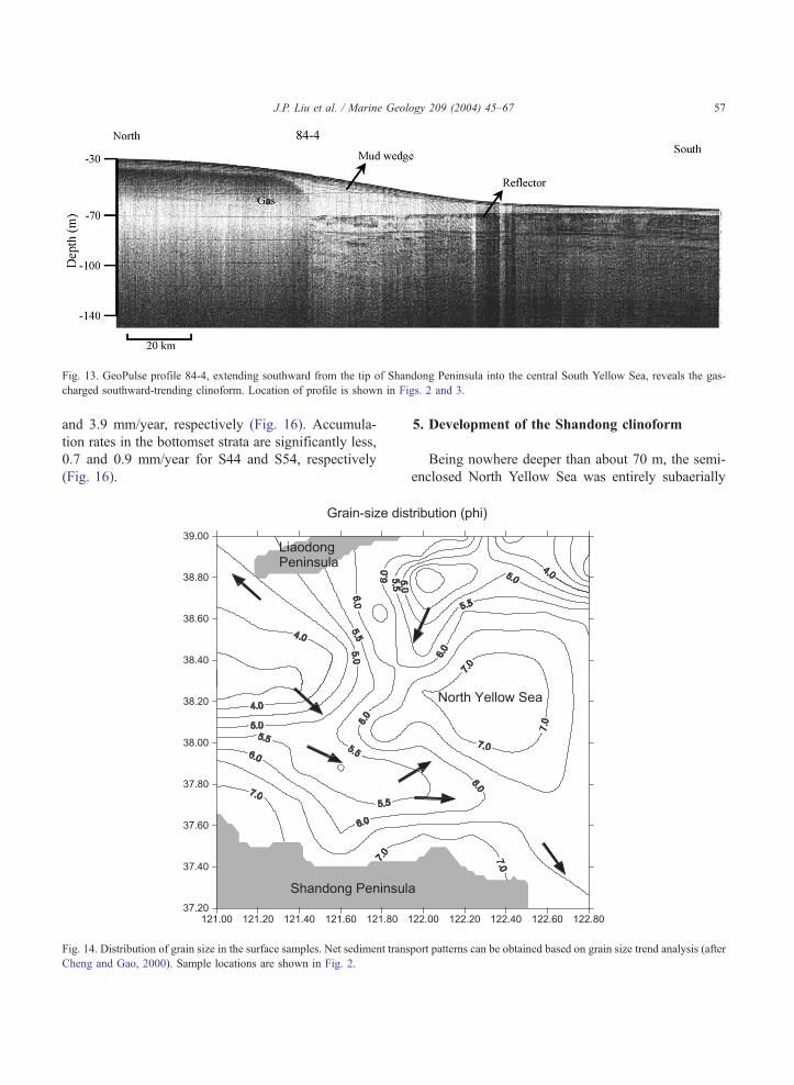
Fig. 13. GeoPulse profile 84-4, extending southward from the tip of Shandong Peninsula into the central South Yellow Sea, reveals the gas-
charged southward-trending clinoform. Location of profile is shown in Figs. 2 and 3.
J.P. Liu et al. / Marine Geology 209 (2004) 45–67 57
and 3.9 mm/year, respectively (Fig. 16). Accumula-
tion rates in the bottomset strata are significantly less,
0.7 and 0.9 mm/year for S44 and S54, respectively
(Fig. 16).
Fig. 14. Distribution of grain size in the surface samples. Net sediment trans
Cheng and Gao, 2000). Sample locations are shown in Fig. 2.
5. Development of the Shandong clinoform
Being nowhere deeper than about 70 m, the semi-
enclosed North Yellow Sea was entirely subaerially
port patterns can be obtained based on grain size trend analysis (after
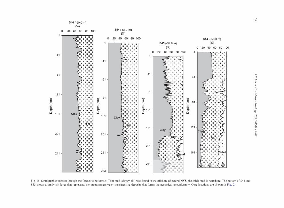
Fig. 15. Stratigraphic transect through the foreset to bottomset. Thin mud (clayey-silt) was found in the offshore of central NYS; the thick mud is nearshore. The bottom of S44 and
S45 shows a sandy-silt layer that represents the pretransgressive or transgressive deposits that forms the acoustical unconformity. Core locations are shown in Fig. 2.
J.P.Liu
etal./Marin
eGeology209(2004)45–67
58

Fig. 16. Activity profile for unsupported (excess) 210Pb of S44, S45, S46, S54, and their linear regression plots with their estimated
sedimentation rates. Core locations are shown in Fig. 3.
J.P. Liu et al. / Marine Geology 209 (2004) 45–67 59
exposed during the last glacial maximum (LGM)
lowstand of sea level. Together with climate, which
has influenced sediment input, the rise of post-LGM
sea level has played a critical role in the development
of the Shandong clinoform. Using an extensive sea-
level database, Liu (2001) have demonstrated that the
post-LGM transgression in the EC/YS and South
Fig. 17. Activity profile for total and excess 210Pb of the core NYS-1, N
China Sea was step-like: long periods of slow trans-
gression (2–8 mm/year) punctuated by several short,
rapid flooding events (f 80 mm/year) (Fig. 18). By
about 15 ka (calendar years), rising sea level had
reached about 100 m (relative to present-day sea level),
and seawater had begun to enter the central SYS. A
rapid rise during melt water pulse 1A (MWP-1A,
YS-2, and S49 on the topset. Core locations are shown in Fig. 3.

Fig. 18. Stepwise postglacial sea-level rise in the western Pacific (YS, ECS, and SCS). The episodic sea-level curve is defined based on extensive collections of sea-level indicators
(fresh water peat, brackish and shallow marine) from the nearshore and submerged continental shelves of ECS (Liu, 2001), Sunda (Hanebuth et al., 2000), and Bonaparte Sea
(Yokoyama et al., 2000).
J.P.Liu
etal./Marin
eGeology209(2004)45–67
60

J.P. Liu et al. / Marine Geology 209 (2004) 45–67 61
Fairbanks, 1989; Bard et al., 1990; Hanebuth et al.,
2000) occurred between 14.3 and 14.1 ka, when sea
level jumped from 95 to 80 m (80 mm/year) trans-
gressing horizontally several to many hundred meters
per year. At the end of this MWP-1A flooding event,
sea level had reached the southern edge of the NYS.
For the ensuing 2500 years, sea level rose slowly (8
mm/year) from 80 to 60 m. Beginning f 11.6 ka, sea
level again jumped from 58 to 43 m (MWP-1B of
Fairbanks), resulting in a rapid westward flooding of
the NYS and initial entrance into the Bohai Sea. Sea-
level rise again stagnated (between � 42 to � 38 m)
for about 1.8 ky, during which much of the early phase
of Shandong clinoform accumulated.
To supply enough sediment into the Shandong
clinoform, however, we need a sediment source as
well as a slow down in the rate of sea-level transgres-
sion. Recent paleoclimatic data suggest that before the
intensification of thde SW monsoon (about 11 ka;
Wang et al., 1999), the Yellow River watershed may
have been dry (Zhao, 1991). The presence of thick
loess deposits along the northern Shandong Peninsula
(Liu and Zhao, 1995) and evidence of relict loess in
the shallow sub-bottom NYS sediments (see above)
lend evidence of an arid glacial climate and therefore
a dry Yellow River. Well-preserved peaty sediments
and possible relict loess deposits indicate little fluvial
input, and we find no evidence on our seismic profiles
of buried or infilled river channels in this area. We
thus conclude that before the intensification of the
summer monsoon about 11 ka, the Yellow River was
at best a minor sediment source.
Evidence of a dramatic intensification of the
southwestern (summer monsoon) about 11 ka has
been noted throughout southern Asia (Wang et al.,
1999), and the initiation of maximum runoff and
sediment discharges also has been observed in other
climate-controlled Asian river systems, such as the
Indus (Prins and Postma, 2000) and Ganges–Brah-
maputra (Goodbred and Kuehl, 2000). We suggest
that it was during this period 1.8-ky interval (11–9.2
ka BP: between MWP-1B and 1C) of slow-rising sea
level and increased Yellow River discharge that the
proximal Yellow River subaqueous delta accreted
over the relict or transgressive facies along the
northern shore of Shandong Peninsula (Fig. 19A).
The acoustically turbid nature of the lower portion of
the clinoform suggests that organic material was
stored in this rapidly accreting proximal clinoform
(Figs. 8–10).
Existence of pre-Holocene peat (f 11 k cal BP)
beneath the mud wedge is another strong evidence for
the increasing monsoonal rainfall on the shelf. After
the river delivered its first phase proximal sediment
over the transgressive layer, the decomposed underly-
ing organic-rich peaty sediment continued to provide
the source of the gas to the overlying sediment (silt to
silty mud). The acoustically transparent upmost layer
(fine mud deposits) appears to be relatively gas-free.
This phenomenon also can be seen other global deltaic
systems, such as the Amazon (Nittrouer et al., 1996),
Ebro (Diaz et al., 1996), and Po (Cattaneo et al.,
2003), etc.
Beginning f 9.8 ka, sea level again rose rapidly,
from 36 to 16 m in f 800 years (f 45 mm/year), a
flooding event that we have termed MWP-1C
(Fig. 18). During this period of rapid transgression,
extreme flooding of the Yellow River at 9.2 ka (Yang
et al., 2000) appears to have diverted the river to the
Jiangsu coast south of the Shandong Peninsula. This
would explain the existence of the flooding surface
(FS) in the seismic profiles (Figs. 9 and 10) as well as
the prominent deltaic sequence noted off the Jiangsu
coast (Milliman et al., 1989). The combination of the
diverted flow and rapid sea-level rise resulted in little
or no Yellow River sediment input to the Shandong
clinoform. After f 7 ka BP, the river apparently
diverted back to the north, but by this time another
pulse of rapidly transgressing sea level (what we term
MWP-1D) had pushed the shoreline 200 km westward.
It was during this distal phase of the Yellow River that
the acoustically transparent facies of the clinoform
began to accumulate (Fig. 19B), a supposition that is
borne out by the following calculations.
By dividing the NYS subaqueous clinoform into a
proximal phase between 11 and 9.2 ka (Fig. 19A) and a
distal phase after 9.2 ka (Fig. 19B), we can calculate a
rough sediment budget. Based on the thickness of the
mud distribution (Fig. 19), using the digital tools in
ArcView-GIS, total sediment volume of the proximal
phase is about 150 km3 or (assuming a specific gravity
of 1.2 t/m3) 180� 109 t. Assuming accumulation over
1.8 ky, when the sea level stood at about � 40 m, and
the old Yellow river emptied directly into the NYS
(Fig. 19A), this yields a mean sediment deposition of
0.1�109 t/year. While the proximal phase sediment

Fig. 19. Proximal (A) and distal (B) mud isopach around the Shandong Peninisula. The dash line in top (A) represents the paleo-coast line
(f� 40 m) formed around 11 ka BP after MWP-1B sea-level rise. The Yellow River is believed to flow into the NYS at that time.
J.P. Liu et al. / Marine Geology 209 (2004) 45–6762
accumulation rate from the Yellow River in the NYS is
about an order of magnitude lower than the modern
river load in the Bohai (0.9� 109 t/year; Galler, 1999),
it appears to correspond closely with estimated pre-
agriculture loads (e.g., Milliman et al., 1987; Saito
et al., 2001). The overlying distal phase (Fig. 19)
resulted in accumulation of an estimated 250 km3 or
300� 109 t of sediment in about 9000 years, giving an
accumulation rate of 0.033� 109 t/year (or 33� 106 t/
year), 1/3 that during the proximal phase. Given the
200-km distance between the modern river mouth and
the clinoform, as well as the fact that for more than 800
years the river discharged south onto the Jiangsu coast,
one might express surprise that the distal rate of
sediment was not lower. This average sediment accu-
mulation of 33� 106 t/year is much higher than the 6–
J.P. Liu et al. / Marine Geology 209 (2004) 45–67 63
8� 106 t/year that Qin and Li (1986) and Martin et al.
(1993) estimated presently escapes from the Bohai,
suggesting that there may be other sources of sediment
to the distal clinoform. This supposition is supported
by mineralogical data that show that surficial sedi-
ments from the topset and foreset strata differ rather
strongly from modern Yellow River sediments (Liu et
al., 1987; Qin et al., 1989), suggesting that the small
local streams and coastal erosion along the northern
coast of the Shandong Peninsula may have contributed
sediment to the clinoform (Fig. 20). We also note that
the bottom part of the foreset slope (which we have
called the ‘‘toe’’) has prograded not only northward
(Figs. 10 and 11), but also to the east (Figs. 8 and 9), in
agreement with the grain size distribution (Cheng and
Gao, 2000; Figs. 14 and 15) and regional circulation
patterns (Figs. 5, 6, and 20). The finer sediments in the
central basin (Fig. 14) suggest net deposition, which is
also shown by the greater sediment thickness in profile
98a (Fig. 12).
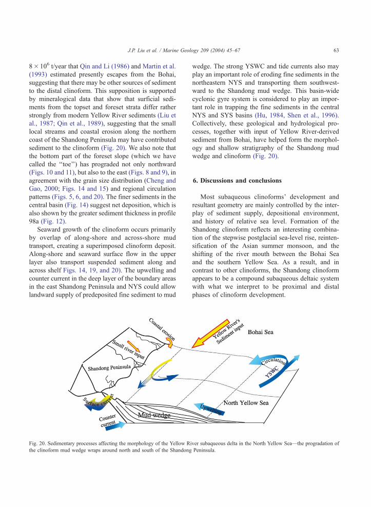
Seaward growth of the clinoform occurs primarily
by overlap of along-shore and across-shore mud
transport, creating a superimposed clinoform deposit.
Along-shore and seaward surface flow in the upper
layer also transport suspended sediment along and
across shelf Figs. 14, 19, and 20). The upwelling and
counter current in the deep layer of the boundary areas
in the east Shandong Peninsula and NYS could allow
landward supply of predeposited fine sediment to mud
Fig. 20. Sedimentary processes affecting the morphology of the Yellow Ri
the clinoform mud wedge wraps around north and south of the Shandong
wedge. The strong YSWC and tide currents also may
play an important role of eroding fine sediments in the
northeastern NYS and transporting them southwest-
ward to the Shandong mud wedge. This basin-wide
cyclonic gyre system is considered to play an impor-
tant role in trapping the fine sediments in the central
NYS and SYS basins (Hu, 1984, Shen et al., 1996).
Collectively, these geological and hydrological pro-
cesses, together with input of Yellow River-derived
sediment from Bohai, have helped form the morphol-
ogy and shallow stratigraphy of the Shandong mud
wedge and clinoform (Fig. 20).
6. Discussions and conclusions
Most subaqueous clinoforms’ development and
resultant geometry are mainly controlled by the inter-
play of sediment supply, depositional environment,
and history of relative sea level. Formation of the
Shandong clinoform reflects an interesting combina-
tion of the stepwise postglacial sea-level rise, reinten-
sification of the Asian summer monsoon, and the
shifting of the river mouth between the Bohai Sea
and the southern Yellow Sea. As a result, and in
contrast to other clinoforms, the Shandong clinoform
appears to be a compound subaqueous deltaic system
with what we interpret to be proximal and distal
phases of clinoform development.
ver subaqueous delta in the North Yellow Sea—the progradation of
Peninsula.

J.P. Liu et al. / Marine Geology 209 (2004) 45–6764
Because of the asymmetry of the late Quaternary
glacio-eustatic cycles, most preserved sedimentary
records on the modern outer shelves (>100 m)
correspond to forced regressive deposits and thick
lowstand system tract (LST), for instance, the outer
shelf of the East China Sea (Berne et al., 2002, Saito
et al., 1998) and the Sunda Shelf (Hanebuth et al.,
2003). With the subsequent rapid sea-level rise and
landward coastline migration, transgressive system
tract (TST) began to develop extensively on the
shelves, which can be recognized through a gradual
or irregular landward shift of transgressive facies
culminating with a maximum flooding surface (mfs)
(Cattaneo and Steel, 2003). On a broad, flat epicon-
tinental shelf lacking ample fluvial input pre-Holo-
cene, the sea-level rise during MWP-1A or 1B could
have advanced landward very rapidly without the
stacking of any thick TST (Fig. 21). Instead, relict
sand, thin transgressive sand deposits, and tidal-in-
duced sand ridges can be formed and extensively
distribute in the middle shelves (Emery, 1968; Liu
et al., 2000; Berne et al., 2002). The TST underlying
Fig. 21. Simplified diagram (after Trincardi et al., 1994) shows differe
epicontinental (b) (e.g., ECS and YS) margins under a high-amplitude ste
the Shandong clinoform presents the sediment stack-
ing formed during the MWP-1B rapid sea-level rise
between 11.6 and 11.2 ka BP (Figs. 18 and 21).
After the rapid rise of sea level (MWP-1B) and
reinitiation of the summer monsoon at 11 ka BP, a
large amount of river-derived sediment was delivered
to the ocean and deposited over the previous (TST). As
discussed earlier, the Yellow River-derived deposits
began to accumulate in the NYS after MWP-1B,f 11
ka BP, about the same time the Yangtze, G–B, Indus,
Mekong, and other Asian rivers experienced increased
discharge and sediment loads: (Chen et al., 2000;
Goodbred and Kuehl, 2000; Prins and Postma, 2000;
Ta et al., 2002). The timing of European clinoforms
and deltas follow a somewhat similar chronology,
apparently in response to both changes in sea-level
rise and sediment delivery. The Ebro River’s distal
prodelta mud deposits, for example, overlie a relict
transgressive sand at 60–80-m water depth, with 14C
ages between 10,000–11,000 years (Diaz et al., 1996).
After Younger Dryas (12.8–11.6 ka) cold event and
decelerated sea-level rise (11 ka), the Guadinna River
nt sequence stratigraphy models between pericontinental (a) and
pwise postglacial sea-level rise (c) (Liu, 2001).

J.P. Liu et al. / Marine Geology 209 (2004) 45–67 65
began to deliver sediment to the mid-shelf of Gulf of
Cadiz (Lobo et al., 2001).
Rapid sea-level rise during MWP-1B provided new
accommodation space that could be quickly filled
during the subsequent lull in sea-level rise, and it
was during this period that the proximal portion of
the Shandong clinoform was formed. The geometry of
this portion of the clinoform was sigmoidal, as is
common in clinoforms that form proximal to river
mouths (Christie-Blick and Driscoll, 1995). After
MWP-1C, f 9 ka BP, however, the Huanghe’s mouth
shifted southward into the south Yellow Sea. By the
time the river again shifted northward, f 7 ka BP, sea
level had risen to + 2–3 m, and the Huanghe’s mouth
was now several hundred kilometers from the Shan-
dong clinoform. The distal portion of the clinoform
appears to have become monoclinal, similar to the way
Driscoll and Karner’s (1999) three-dimensional nu-
merical model would predict a clinoform to form away
from the source (Driscoll and Karner, 1999). A similar
pattern is seen in a number of clinoforms, such as the
Amazon (Nittrouer et al., 1996), Ebro (Diaz et al.,
1996), and Po (Trincardi et al., 1994, Cattaneo et al.,
2003). Driscoll and Karner’s 3-D model also shows an
onlap surface that can be generated when the sediment
is transported along shelf away from the sediment
source. For the most part, the Shandong clinoform
does not follow this rule; instead, it has downlap
deposits prograding over a relict transgressive layer
in the toe region (see profiles 99-A, 99-B, and 99-F;
Figs. 8–10). In a similar way, seismic profiles from the
center of the Canterbury Basin, New Zealand, dem-
onstrate that downlap surfaces of highstand system
tract (HST) overlie previously deposited toe-of-clino-
form sediment (Carter et al., 1998).
More interestingly, different from other river sys-
tems, the Yellow River deltaic deposits indicate a very
unique way dispersing its sediment to the ocean, where
they are influenced uniquely by formation of the
negatively (hyperpycnal) buoyant sediment plumes,
seasonal resuspension, and longshore current transpor-
tation. The dominant negatively hyperpycnal plumes
travel very shorter distance near the modern Yellow
River mouth (Wright et al., 2001); after that, the Yellow
River-derived fine sediments are resuspended, mainly
in winter seasons, and are continually transported long
distance along margins in a semihyperpycnal flow
(Fig. 6). Together with the along-shelf transport,
cross-shelf advection appears to play an important role
in the development of a clinoform downstream from
the sediment source-river mouth.We suggest that when
a precipitous change of the coastal configuration
occurs, along-shore sediment transport can shift to
cross-shore transport. For instance, around the eastern
end of the Shandong Peninsula, alongshore sediment
transport appears to change from east to south. A
similar situation is seen in the Adriatic Sea, where the
Gargano promontory shifts along-shore transport and
increases cross-shore transport (Cattaneo et al., 2003).
The change from along-shore to cross-shore transport
may explain the sequence stratigraphic shift from
aggradational onlap to progradational downlap.
Acknowledgements
Many thanks to the crews of RVGoldstar II and our
Chinese and American colleagues for their help in
obtaining and processing data. We thank L.D. Wright,
Y. Saito, S. Kuehl N. Driscoll, and Z.S. Yang for their
many helpful comments on an earlier version of this
paper. Financial supports for this program from
National Science Foundation of U.S. and China, the
Office of Naval Research. And many thanks Woods
Hole Oceanographic Institution’s Postdoctoral Scholar
Program with funding provided by the U.S. Geological
Survey to Liu. This is also contribution no. 2612 from
Virginia Institute of Marine Science, College of
William & Mary.
References
Alexander, C.R., DeMaster, D.J., Nittrouer, C.A., 1991. Sediment
accumulation in a modern epicontinental-shelf setting: the Yel-
low Sea. Marine Geology 98, 51–72.
Bard, E., Hamelin, B., Fairbanks, R.G., 1990. U–Th ages obtained
by mass spectrometry in corals from Barbados: sea level during
the past 130000 years. Nature 346 (6283), 456–458.
Berne, S., et al., 2002. Pleistocene forced regressions and tidal
sand ridges in the East China Sea. Marine Geology 188 (3–4),
293–315.
Bornhold, B.D., Yang, Z.S., Keller, G.H., Prior, D.B., Wiseman,
W.J., Wang, Q., Wright, L.D., Xu, W.D., Zhuang, Z.Y., 1986.
Sedimentary framework of the modern Huanghe (Yellow River)
Delta. Geo-Marine Letters 6, 77–83.
Carter, R.M., Fulthorpe, C.S., Naish, T.R., 1998. Sequence con-
cepts at seismic and outcrop scale: the distinction between phys-

J.P. Liu et al. / Marine Geology 209 (2004) 45–6766
ical and conceptual stratigraphic surfaces. Sedimentary Geology
122 (1–4), 165–179.
Cattaneo, A., Steel, R.J., 2003. Transgressive deposits: a review of
their variability. Earth-Science Reviews 62 (3–4), 187–228.
Cattaneo, A., Correggiari, A., Langone, L., Trincardi, F., 2003. The
late-Holocene Gargano subaqueous delta, Adriatic shelf: sedi-
ment pathways and supply fluctuations. Marine Geology 193
(1–2), 61–91.
Chen, Z.Y., Song, B.P, Wang, Z.H, Cai, Y.L, 2000. Late Quaternary
evolution of the sub-aqueous Yangtze Delta, China: sedimenta-
tion, stratigraphy, palynology, and deformation. Marine Geology
162, 243–441.
Cheng, P., Gao, S., 2000. Net sediment transport patterns over the
northwestern Yellow Sea, based on grain-size tread analysis.
Oceanologia et Limnologia Sinica 31 (6), 604–615.
Christie-Blick, N., Driscoll, N.W., 1995. Sequence stratigraphy.
Annual Review of Earth and Planetary Sciences 23, 451–478.
Cutshall, N.H., Larsen, I.L., Olsen, C.R., 1983. Direct analysis of210Pb in sediment samples: shelf-absorption correction. Nuclear
Instruments and Methods 206, 309–312.
Diaz, J.I., Palanques, A., Nelson, C.H., Guillen, J., 1996. Morpho-
structure and sedimentary of the Holocene Ebro prodelta mud
belt (northwestern Mediterranean Sea). Continental Shelf Re-
search 16 (4), 435–456.
Driscoll, N.W., Karner, G.D., 1999. Three-dimensional quantitative
modeling of clinoform development. Marine Geology 154 (1–4),
383–398.
Emery, K.O., 1968. Relict sediments on continental shelves of
world. American Association of Petroleum Geologists Bulletin
52 (3), 445–464.
Fairbanks, R.G., 1989. A 17,000-year glacio-eustatic sea level re-
cord: influence of glacial melting rates on the Younger Dryas
event and deep ocean circulation. Nature 342, 637–642.
Galler, J.J., 1999. Medium and long-term changes in fluvial dis-
charge to the sea: the Yellow River case study. Master of Sci-
ence thesis, College of William & Mary, 78 pp.
Goodbred, S.L., Kuehl, S.A., 2000. The significance of large
sediment supply, active tectonism, and eustasy on margin se-
quence development: Late Quaternary stratigraphy and evolu-
tion of the Ganges–Brahmaputra delta. Sedimentary Geology
133, 227–248.
Guan, B.X., 2000. Inversion thermocline in coastal region north and
east of Shandong Peninsula in winter and its relation to deep-
bottom counter current. Journal of Oceanography of Huanghai
& Bohai Seas 18 (3), 66–71.
Hanebuth, T., Stattegger, K., Grootes, P.M., 2000. Rapid flooding
of the Sunda Shelf: a late-glacial sea-level record. Science 288,
1033–1035.
Hanebuth, T.J.J., Stattegger, K., Schimanski, A., Ludmann, T.,
Wong, H.K., 2003. Late Pleistocene forced-regressive deposits
on the Sunda Shelf (Southeast Asia). Marine Geology 199 (1–2),
139–157.
Hu, D.X., 1984. Upwelling and sedimentation dynamics. Chinese
Journal of Oceanology and Limnology 2 (1), 12–19.
Jiang, W.S., Pohlmann, T., Sundermann, J., Feng, S.Z, 2000. A
modeling study of SPM transport in the Bohai Sea. Journal of
Marine Systems 24, 175–200.
Kim, Y.H., Chough, S.K., Lee, H.J., Chun, S.S., Han, S.J., 1999.
Holocene transgressive stratigraphy of a macrotidal flat in the
southeastern Yellow Sea: Gomso Bay, Korea. Journal of Sedi-
mentary Research. Section B, Stratigraphy and Global Studies
69 (2), 328–337.
Kuehl, S.A., DeMaster, D.J., Nittrouer, C.A., 1986. Nature of sed-
iment accumulation on the Amazon continetal shelf. Continental
Shelf Research 6, 209–225.
Kuehl, S.A., Levy, B.M., Moore, W.S., Allison, M.A, 1997. Sub-
aqueous delta of the Ganges–Brahmaputra river system. Marine
Geology 144, 81–96.
Li, F., Ding, Z.X., 1996. Vertical distribution patterns of suspended
matter and near bottom turbid water layer in the South Yellow
Sea. Studia Marina Sinica 37, 33–42.
Liu, J.P., 2001. Post-glacial sedimentation in a river-dominated
epicontinental shelf: the Yellow Sea example. PhD Dissertation,
College of William & Mary, VA, USA.
Liu, J.P., Zhao, S.L., 1995. Origin of the buried loess in the Bohai
Sea bottom and the exposed loess along the coastal zone. Oce-
anologia et Limnologia Sinica 26, 363–368.
Liu, M.H., Wu, S.Y., Wang, Y.J., 1987. Late Quaternary Sediments
of the Yellow Sea. China Ocean Press, Beijing, p. 433.
Liu, Z.X., Xia, D.X., Berne, S., Wang, K.Y., Marsset, T., Tang,
Y.X., Bourillet, J.F., 1998. Todal deposition systems of China’s
continental shelf, with special reference to the eastern Bohai
Sea. Marine Geology 145, 225–253.
Liu, Z.-X., Berne, S., Saito, Y., Lericolais, G., Marsset, T., 2000.
Quaternary seismic stratigraphy and paleoenvironments on the
continental shelf of the East China Sea. Journal of Asian Earth
Sciences 18 (4), 441–452.
Liu, J.P., Milliman, J.D., Gao, S., 2002. The Shandong mud wedge
and post-glacial sediment accumulation in the Yellow Sea. Geo-
Marine Letters 21, 212–218.
Lobo, F.J., Hernandez-Molina, F.J., Somoza, L., Diaz del Rio, V.,
2001. The sedimentary record of the post-glacial transgression
on the Gulf of Cadiz continental shelf (Southwest Spain). Ma-
rine Geology 178 (1–4), 171–195.
Martin, J.M., Zhang, J., Shi, M.C., Zhou, Q., 1993. Actual flux
of the Huanghe (Yellow River) sediment to the western
Pacific Ocean. Netherlands Journal of Sea Research 31,
243–254.
McManus, J., 1988. Grain-size determination and interpretation. In:
Tucker, M. (Ed.), Techniques in Sedimentology. Blackwell, Ox-
ford, pp. 63–85.
Milliman, J.D., Meade, R.H., 1983. World-wide delivery of river
sediment to the oceans. Journal of Geology 91, 1–21.
Milliman, J.D., Syvitski, J.P.M., 1992. Geomorphic/tectonic control
of sediment discharge to the ocean: the importance of small
mountainous rivers. Journal of Geology 100, 525–544.
Milliman, J.D., Li, F., Zhao, Y.Y., Zheng, T.M., Limeburner, R.,
1986. Suspended matter regime in the Yellow Sea. Progress in
Oceanogography 17, 215–227.
Milliman, J.D., Qin, Y.S., Ren, M.E., Saito, Y., 1987. Man’s influ-
ence on the erosion and transport of sediment by Asian rivers:
the Yellow River (Huanghe) example. Journal of Geology 95,
751–762.
Milliman, J.D., Qin, Y.S., Park, Y., 1989. Sediment and sedimentary
J.P. Liu et al. / Marine Geology 209 (2004) 45–67 67
processes in the Yellow and East China Seas. In: Taira, A.,
Masuda, F. (Eds.), Sedimentary Facies in the Active Plate Mar-
gin, Terra Scientific, Tokyo, pp. 233–249.
Morgan, J.P., 1970. Deltaic Sedimentation: Modern and Ancient.
SEPM Special Publication 15, 312 pp.
Nittrouer, C.A., Kuehl, S.A., DeMaster, D.J., Kowsmann, R.O.,
1986. The deltaic nature of Amazon shelf sedimentation. Geo-
logical Society of America Bulletin 97, 444–458.
Nittrouer, C.A., Kuehl, S.A., Figueiredo, A.G., Allison, M.A.,
Sommerfield, C.K., Rine, J.M., Faria, L.E.C., Silveira, O.M.,
1996. The geological record preserved by Amazon shelf sedi-
mentation. Continental Shelf Research 16, 817–841.
Park, Y.A., Lim, D.I., Khim, B.K., Choi, J.Y., Doh, S.J., 1998.
Stratigraphy and subaerial exposure of Late Quaternary tidal
deposits in Haenam Bay, Korea (south-eastern Yellow Sea).
Estuarine, Coastal and Shelf Science 47 (4), 523–533.
Prins, M.A., Postma, G., 2000. Effects of climate, sea level, and
tectonics unraveled for last deglaciation turbidite records of the
Arabian Sea. Geology 28, 375–378.
Qian, N., Dai, D.Z., 1980. The problems of river sedimentation and
present status of its research in China. Chinese Hydraulic Engi-
neering, Proceedings of the International Symposium of River
Sedimentation 1, 1–39.
Qin, Y.S., Li, F., 1986. Study of the influence of sediment loads
discharged from Huanghe river on sedimentation in the
Bohai and Yellow Seas. Oceanologia et Limnologia Sinica 27,
125–135.
Qin, Y.S., Zhao, Y.Y., Chen, L.R., Zhao, S.L., 1989. Geology of the
Yellow Sea. China Ocean Press, Beijing, p. 289.
Saito, Y., Yang, Z.S., 1995. Historical change of the Huanghe (Yel-
low River) and its impact on the sediment budget of the East
China Sea. In: Tsunogai, S., Iseki, K., Koike, I., Oba, T. (Eds.),
Global Fluxes of Carbon and Its Related Substances in the
Coastal Sea–Ocean–Atmosphere System. M&J International,
Yokohama, pp. 7–12.
Saito, Y., Katayama, H., Ikehara, K., Kato, Y., Matsumoto, E.,
Oguri, K., Oda, M., Yumoto, M., 1998. Transgressive and high-
stand systems tracts and post-glacial transgression, the East Chi-
na Sea. Sedimentary Geology 122, 217–232.
Saito, Y., Yang, Z.S., Hori, K., 2001. The Huanghe (Yellow River)
and Changjiang (Yangtze River) deltas: a review on their char-
acteristics, evolution and sediment discharge during the Holo-
cene. Geomorphology 41, 219–231.
Shen, S.X., Li, A.C., Yuan, W., 1996. Low energy environment of
the central South Yellow Sea. Oceanologia et Limnologia Sinica
27 (5), 518–523.
Stuiver, M., Reimer, P.J., Bard, E., Beck, J.W., Burr, G.S., Hughen,
K.A., Kromer, B., McCormac, F.G., v. d. Plicht, J., Spurk, M.,
1998. INTCAL98 radiocarbon age calibration 24,000-0 cal BP.
Radiocarbon 40, 1041–1083.
Sun, X.G., Fang, M., Huang, W., 2000. Spatial and temporal var-
iations in suspended particulate matter transport on the Yellow
and East China Sea shelf. Oceanologia et Limnologia Sinica 31
(6), 581–587.
Ta, T.K.O., Nguyen, V.L., Tateishi, M., Kobayashi, I., Tanabe, S.,
Saito, Y., 2002. Holocene delta evolution and sediment dis-
charge of the Mekong River, southern Vietnam. Quaternary
Science Reviews 21, 1807–1819.
Trincardi, F., Correggiari, A., Roveri, M., 1994. Late Quaternary
transgressive erosion and deposition in a modern epicontinental
shelf: the Ariatic Semienclosed Basin. Geo-Marine Letters 14,
41–51.
Wang, L., Sarnthein, M., Erlenkeuser, H., Grimalt, J., Grootes, P.,
Heilig, S., Ivanova, E., Kienast, M., Pelejero, C., Pflaumann, U.,
1999. East Asian monsson climate during the Late Pleistocene:
high-resolution sediment records from the South China Sea.
Marine Geology 156, 245–248.
Wright, L.D., Coleman, J.M., 1973. Variation in morphology of
major deltas as functions of ocean wave and river discharge
regime. AAPG Bulletin 57, 370–398.
Wright, L.D., Wiseman, W.J., Bornhold, B.D., Prior, D.B.,
Suhayda, J.N., Keller, G.H., Yang, Z.S., Fan, Y.B., 1988. Ma-
rine disperal and deposition of Yellow River silts by gravity-
driven underflows. Nature 332, 629–632.
Wright, L.D., Wiseman, W.J., Yang, Z.S., Bornhold, B.D., Keller,
G.H., Prior, D.B., Suhayda, J.N., 1990. Processes of marine
dispersal and deposition of suspended silts off the modern
mouth of the Huanghe (Yellow River). Continental Shelf Re-
search 10, 1–40.
Wright, L.D., Friedrichs, C.T., Kim, S.C., Scully, M.E., 2001. Effects
of ambient currents and waves on gravity-driven sediment
transport on continental shelves. Marine Geology 175 (1–4),
25–45.
Xia, Z.W., Guo, B.H., 1983. Cold water and upwelling around the
tips of Shandong Peninsula and Liaodong Peninsula. Journal of
Oceanography of Huanghai & Bohai Seas 1, 13–19.
Yanagi, T., Inoue, K., 1995. A numerical experiment on the sedi-
mentation processes in the Yellow Sea and the East China Sea.
Journal of Oceanography 51, 537–552.
Yang, Z.S., Milliman, J.D., Galler, J., Liu, J.P., Sun, X.G., 1998.
Yellow river’s water and sediment discharge decreasing steadily.
EOS 79 (48), 589–592.
Yang, D.Y., Yu, G., Xie, Y.B., Zhan, D.J., Li, Z.J., 2000. Sedimen-
tary records of large Holocene floods from the middle reaches of
the Yellow River, China. Geomorphology 33, 73–88.
Yokoyama, Y., Fifield, L.K., Lambeck, K., De Deckker, P., John-
ston, P., 2000. Timing of the Last Glacial Maximum from ob-
served sea-level minima. Nature 406 (6797), 713–716.
Yuan, Y., Su, J., 1984. Numerical modelling of the circulation in
the East China Sea. In: Ichiiye, T. (Ed.), Ocean Hydrodynamics
of Japan and East China Sea. Elsevier Oceanography Series,
vol. 39. Elsevier, New York, pp. 167–186.
Zhao, S.L., 1991. China shelf sea desertization and its derived
deposits during the last stage of Late Pleistocene. Oceanologia
et Limnologia Sinica 22 (3), 285–293.
Zhao, B.R., 1996. A study of the circulations of the northern Yellow
Sea cold water mass—effects of tidal mixing on them. Ocean-
ologia et Limnologia Sinica 27 (4), 429–435.
Zheng, Q.A., Klemas, V., 1982. Determination of winter tempera-
ture patterns, fronts, and surface currents in the Yellow Sea and
East China Sea from satellite imagery. Remote Sensing of En-
vironment 12, 201–218.