Embed Size (px)
Citation preview

28
JM1 S15/1627 Target Decision Date:27th January 2016Committee Date:23rd August 2016
Applicant M Parker & Sons Ltd Tate Business Park Dozens Bank Pode Hole Spalding
Agent Brian Gilham 2 Edinburgh Walk Holbeach Spalding LincsProposal Erection of 5 no. dwellings with associated private drive following
demolition of existing dwelling and buildingsLocation White House Nurseries 23 The Green Thurlby Bourne
Lincolnshire PE10 0HBApplication Type Full Planning PermissionParish(es) Thurlby Parish Council
Reason for Referral to Committee
Requested by Cllr Powell and Cllr Dobson
Recommendation That the application is:- Approved conditionally
Key Issues
Principle of Use Impact on Character of Area Impact on residential community Highway Safety Drainage
Technical Documents Submitted with the Application
Design & Access Statement Supporting Statement Tree Report Desktop Report (Grand Investigations( Plans & Elevations
Enquires about this report to: Joe Mitson Planning Officer 01476 406080 [email protected]

28

30
1.0 Description of site and application
1.1 Site
1.1.1 The site is situated on White House Nurseries, The Green, Thurlby in an area which is predominantly residential, albeit some of the properties on The Green are used as commercial premises. The site is occupied by a dwelling, No. 23 The Green and a former commercial nursery and covers a large area expanding along the rear of gardens to properties on Obthorpe Lane, The Green, High Street and Old School Close . The nursery lies to the rear of the main dwelling and there are a number of small outbuildings and glasshouses to the rear of the site. The dwelling and nursery are both accessed via an existing access off The Green.
1.1.2 The site is bordered by the rear gardens of properties on The Green to the east and west and then the rear of dwellings along Obthorpe Lane to the east and Old School Close to the west. Further to the south west and south the site is boarded by agricultural fields. The site lies within the built form of the settlement.
1.2 Proposal
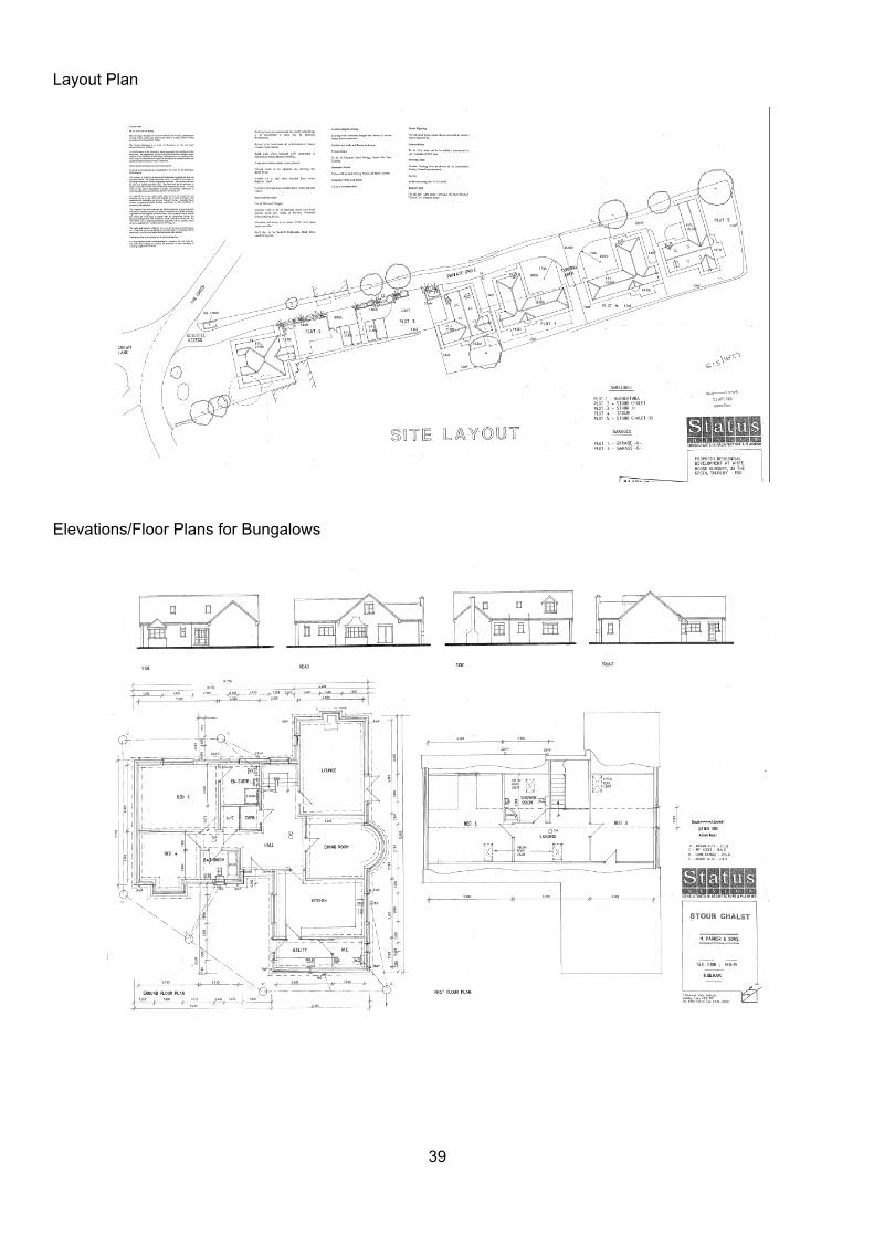
1.2.1 The application proposes the demolition of the dwelling and the creation of 5 detached dwellings all served from a single access point on The Green. Plot 1 to the frontage of the site is a detached three bedroom bungalow with a rear garage, Plot 2 would be a detached 4 bedroom chalet bungalow with a detached garage, plots 3 and 4 are detached three bedroom bungalows with integral garaging and Pot 5 is detached 4 bedroom chalet bungalow with integral garage.
2.0 Relevant History
Reference Proposal Decision DateS15/2055 Lawful Development Certificate A1 shop Unlawful
Development 13/10/2015
3.0 Policy Considerations
3.1 National Planning Policy Framework (NPPF)Section 6 - Wide choice of high quality homesSection 7 - Requiring good designSection 11 - Enhancing the natural environment
3.2 South Kesteven District Council Core StrategyPolicy SP1 - Spatial StrategyPolicy SP2 - Sustainable CommunitiesPolicy EN1 - Protection and Enhancement
3.3 Site Allocation and Policies Development Plan DocumentPolicy SAPH1 - Other housing development
4.0 SKDC Corporate Priorities
4.1 Support good housing for all

31
5.0 Representations Received
Parish Council Objects based on the following;Increase in traffic on High Street/Station RoadThe site is close to 4 separate junctions and on a sharp dangerous bend. Opposite a very busy veterinary practice and the junction at The Green where there is a post office and local shop. Both roads lead to the primary school and are well used and busy at certain times of the day. If granted there would be 10-12 extra cars exiting onto a dangerous bend and already busy road.Service vehicles would not drive into the development but stop on the bend.When the A15 is closed all traffic is diverted through Thurlby and past this site.The school bus opposite collects and drops off children going to school in Bourne. Misrepresentation in the planning application about the use of the site, it was never that frequently used.The sewerage in the village is close or over capacityPossible flooding in Obthorpe Lane, there is already an issue with flooding in the area due to the drains being at full capacity. Danger to pedestrians trying to cross the road by the site due to additional carsThe site is not allocated and should not be allowed to happen.It would be back building.
The Parish Council have commented on the amended plans stating that the amendment does not overcome their original objection set out above.
LCC Highways & SuDS Support No objection subject to conditions.
Heritage Lincolnshire No archaeological implications.
Environmental Protection Services No objection subject to conditions.
6.0 Representations as a Result of Publicity
6.1 This application has been advertised in accordance with the Council's Statement of Community Involvement and 23 properties have made representation. Recent amended plans have been consulted upon and a further 7 properties have made representation. The points raised can be summarised as follows:
32
Drainage - the development would cause strain to the already beyond capacity drainage and sewerage infrastructure in Thurlby. Many of the dykes in the village are filled due to increased development in the village and water has nowhere to go other than to run off and flood the roads. The proposed development will lead to increased run off water and exacerbate existing drainage problems. The design of the proposal increase hard standing and paved driveways limiting free draining capacity of the site and increase risk of surface water runoff into a drainage network which is at capacity.
Highways - the access to the property together with the significant volumes of traffic passing along High Street will result in the increased probability of an incident. The access is on an already dangerous and very busy junction in the village. It is on a blind bend opposite a busy junction used for school, shop, community hall and veterinary practice. There is no weight restriction through the village adding more hazards to an already hazardous junction. The vast majority of residents use their car to access shops, facilities and workplace increasing traffic through the village.
There has never been a significant amount of traffic to the site and there is misleading information in the supporting statement. Pedestrian access to the site would be a major hazard.
Impact on the character of the area - would change the site from agricultural to residential impact on the character of this area of the village. It is not a brownfield site. The application is for backfill/backland development and is for too many units. Demolishing the property to replace it with modern structures would have a devastating effect on the beauty of the village. The site is at the hub of the village and the proposal would not fit in with the original part of the village. Result in over development of the site. The proposed materials are out of keeping with neighbouring dwellings
Impact on residential properties - the development would be obtrusive to the houses on Northorpe Lane, High Street, The Green and Station Road. Impact of lighting on the drive to residents. Overlooking to gardens. Driveway would create noise and harmful fuel emissions.
The site is valuable farmland which could be incorporated into the arable land which it borders Risk of contamination Trees to be removed The previous use of the site is misleading. The size of the village has significantly increased. Concern over the boundary line to No. 2 Old School Close and the damson trees along the
boundary line being removed. The development is contrary to SKDC policies Errors/omissions on the plans. The garage to 2a is not shown on plan, trees not denoted Height of drive - retaining wall due to height and weights of drive and this would put more
pressure on the boundary. The land is not stable enough to support any traffic, construction traffic or the development. Construction work would destroy the adjoining barns Bin stores - storage of bins away from properties is a potential health hazard. Impractical and
inconvenient
6.2 With regards to the amended plans letters of representation have been received stating that their previous objection still stands.
7.0 Evaluation
7.1 Principle of the use
7.1.1 The site is located within Thurlby which is identified as a Local Service Centre in Policy SP1 and SP2 of the Adopted Core Strategy where development will be allowed in accordance with the Spatial Strategy and preference will be given to brownfield sites within the built up part of the settlements which do not compromise the nature and character of the village. Policy SAP H1 of the adopted Site Allocations and Policy DPD (2014) includes detailed criteria against which all such residential development proposals should be assessed.

33
7.1.2 The proposal is for the demolition of the existing house (No.23 The Green) and other buildings on the site and the erection of five residential properties. One of the plots would be sited to the frontage of the site and the other four on land to the rear of properties fronting Obthorpe Lane.
7.1.3 There are therefore two distinct parts to the site. The existing house and associated curtilage buildings fronting The Green can largely be considered as previously developed land in accordance with the definition included in the NPPF. However, the definition specifically excludes domestic gardens which are, therefore, greenfield land. The rear portion of the site, which includes a large glass house is on open land on the edge of the village. Appendix 2 of the NPPF is clear that previously development land is that which is or was occupied by a permanent structure, including the curtilage of the development land, and any associated fixed surface infrastructure. The definition is also clear that previously development land excludes land which is, or has been, occupied by agricultural building and private gardens. The rear of the site has been used for agricultural purposes and the glasshouses were used for growing various agricultural produce. Thus, the previous use has been agricultural and the land, cannot, therefore, be regarded as previously developed land.
7.1.4 The site is predominantly within a residential area and the frontage part of the site sites within the built form of the village. The demolition and redevelopment of the existing house and its garden for a small infill residential scheme would be considered to accord with the principles of sustainable development set out in the NPPF and the requirements of policies SP1, SP2 and SAP H1. The remainder of the site, to the rear, which includes the glasshouse, cannot be regarded as previously developed land. Policy SAP H1 is clear that other than those sites which are allocated, new greenfield sites on the edge of villages will not be considered acceptable for housing development. Therefore, any development on this part of the site considered to be greenfield would be contrary to the development plan.
7.1.5 As the site is not considered to be brownfield the principle of the development is not wholly supported in policy terms. However, the site does not have the appearance of an undeveloped site and clearly has been used as a nursery/commercial site in the past with the retention of some sheds and glasshouses. Located on the edge of a sustainable settlement, one which supports infill and redevelopment, careful consideration of the suitability of the site is required. Therefore, the benefits of the scheme, the provision of housing and redevelopment of an untidy site, needs to be considered against the harm of the proposal, the loss of a 'greenfield' site. As stated the site does not have the general appearance of greenfield, with the exception of the lower part of the site to the south, and therefore the harm to the nature and character of the area is limited. On balance the benefits of the scheme outweigh the harm and the redevelopment of the site is considered to be acceptable.
7.2 Impact of the use on the character of the area
7.2.1 The site contains a large detached dwelling house and a number of structures, including polytunnels, glasshouses and sheds and has been used as a plant nursery/commercial premises. Situated towards the centre of the village close to the junction with four roads the site has a presence on High Street/The Green. The existing property, No, 23, is set back from the highway with a large open plan well maintained front garden.
7.2.2 Developing the frontage of the site with a detached bungalow would alter the character of the area and this part of the streetscene. However, Plot 1 would still be set back from the highway and the layout would maintain an area of open frontage garden respecting the form and character of the area. The building would still be behind existing properties on The Green and High Street and would mirror the form of this side of the highway as it leads around the bend to High Street to the east.
7.2.3 To the rear of the dwelling are a number of structures which are now relatively disused and falling into disrepair. These structures and appearance of the site are not considered to contribute to the character of the area.

34
7.2.4 The site is relatively well screened with the exception of the most southern and western boundary which could be viewed long distance across agricultural land/open countryside. However, this would be viewed against residential properties on Obthorpe Road limiting its impact on the nature and character of the area.
7.2.5 The southernmost part of the site is more open and undeveloped in nature. Whilst the application can be seen as encroachment and expansion of the village by utilising a greenfield site the harm is limited by the current state and use of the site and that the proposal naturally infills within the existing built form along The Green, Obthorpe Road and Old School Close with limited impact on the open countryside.
7.2.6 It is therefore considered the proposal would be sympathetic to the prevailing character and appearance of the site and street scene and comply with the NPPF particularly with regard to the need to secure good design, Policy SAPH1 of the SAPDPD and EN1 of the CS.
7.3 Impact on the neighbouring properties
7.3.1 Plot 1 of the proposed development would be sited forward of the existing building on the site, No. 23, which would be demolished as part of the development. The new bungalow would be forward of the host property on land which was previously garden. The garden to the frontage is well maintained and open fronted to The Green. Sited forward the proposed bungalow on Plot 1 would be more in line with No's 20a and 22 The Green but set slightly back to reflect the bend in the road to the east toward No. 2a High Street. The main aspects of the adjoining property to the west, No. 22 The Green, face north to south and the creation of a single storey property with only ground floor windows facing the shared boundary would not have a detrimental impact on the residential amenities of this property.
7.3.2 To the west of the site, to the rear of the existing dwelling, Plots 2 - 5 would be sited leading back into the site. On the site of No. 23 would be two garages which would serve Plot 1 and Plot 2. This is along the rear boundary of No. 22 and close to the rear boundaries of properties to Old School Close. There is some distance between the rear aspects of Old School Close, The Green and the proposed plots to the rear of the site. Plots 2 to 5 predominantly only have ground floor windows facing the west boundary with the exception of two first floor windows to plot 2 and plot 5. However, due to the distance separations involved and Plots 3, 4 and 5 adjoin an agricultural field the siting of these plots would not adversely impact on the residential amenities of properties to the west on The Green and Old School Close.
7.3.3 Along the southern and southwest boundary is agricultural land which would not be unduly impacted on by the proposed development.
7.3.4 To the east boundary of the site are the rear of properties on High Street and Obthorpe Lane. No. 2 and No. 2a High Street currently have their outlook toward the existing dwelling on the site, No. 23. This property is to be demolished and in its place would be two single storey garage and driveways serving Plot 1 and Plot 2. The demolition of the main dwelling and the replacement garages would improve the outlook to these properties. Concern has been expressed with regards to the retaining wall to these properties and damage to the outbuildings which are along this boundary, this is considered to be a private legal matter.
7.3.5 Further to the south east of the site are the rear gardens and properties on Obthorpe Lane. Plots 2 to 5 would face the rear of these properties. The application proposes single storey dwelling and chalet bungalows. The proposed bungalows would have no first floor windows projecting towards the rear gardens of Obthorpe Lane and with suitable boundary treatment would not overlook the rear of these properties. The single storey nature of these properties would ensure that there is no overbearing impact on the rear gardens and properties on Obthorpe Lane.

35
7.3.6 Notwithstanding the objections received it is not considered the proposal would have an undue adverse impact on the residential amenities of occupiers of neighbouring properties. Furthermore, conditions can be imposed removing permitted development rights for extensions to the dwellings. As such the proposal accords with the provisions of the NPPF, EN1 and Policy SAPH1 of the SAPDPD.
7.4 Highway issues
7.4.1 Access is proposed off The Green, utilising the existing access which currently serves the dwelling and the nursery. The layout shows a single drive serving the dwellings which would all have their own parking and turning area, including external and integral garaging. Amended plans have been submitted to address the concerns of the highway authority with regards to emergency vehicles. There have been a significant number of objections received with regards to the use of the access for 5 dwellings, its position on a dangerous bend and at the junction with four roads. As part of the application a traffic speed survey was undertaken. The Highway Authority have assessed the data and the proposed plans and consider that the visibility from the junction to be acceptable. The Highway Authority have confirmed no objections to the proposal. Overall the proposal is considered to be acceptable in highway safety terms.
7.5 Flood Risk and Drainage
7.5.1 Significant objections have been received with regards to the issue of drainage capacity and surface water flooding. The application has been considered and assessed by the County Councils Flood Risk and Development Manager who have requested that a condition be imposed to require a FRA to ensure mitigation is put in place. A condition can be imposed to provide sustainable urban drainage and to ensure that run-off rate is no greater than greenfield so as not to exacerbate and existing problem. It is considered that adequate measures can be put in place so that the proposal would not have a greater impact on drainage or surface water run-off.
7.6 Other
7.6.1 Comments have been submitted with to shared boundaries, right of access, right to works to trees and damage to retaining walls and structures on the boundaries. These issues are considered to be private legal matters and do not fall within the planning legislation.
7.7 Conclusion
7.7.1 Overall, whilst not wholly in accordance with Policy, the proposal is considered capable of accommodating five single storey dwellings. The proposal is considered to respect the character of the area by redevelopment of the site and no adverse loss of residential amenity is considered to occur to the occupants of neighbouring residential properties. Finally, the proposal is also considered acceptable in terms of highway safety.
8.0 Crime and Disorder
8.1 It is considered that the proposal would not result in any significant crime and disorder implications.
9.0 Human Rights Implications
9.1 Articles 6 (Rights to fair decision making) and Article 8 (Right to private family life and home) of the Human Rights Act have been taken into account in making this recommendation. It is considered that no relevant Article of that act will be breached.
36
10.0 RECOMMENDATION: that the development is Approved subject to the following conditions
Time Limit for Commencement
1 The development hereby permitted shall be commenced before the expiration of three years from the date of this permission.
Reason: In order that the development is commenced in a timely manner, as set out in Section 91 of the Town and Country Planning Act 1990 (as amended).
Approved Plans
2 The development hereby permitted shall be carried out in accordance with the following list of approved plans:
1:1250 Location PlanSD14-046/6BlencathraStour ChaletStour HStourStour Chalet DG2Stour Chalet DG1Garages A and BSD14-046/5
Unless otherwise required by another condition of this permission.
Reason: To define the permission and for the avoidance of doubt.
Before the Development is Commenced
3 Before any part of the development hereby permitted is commenced a surface water drainage scheme for the site (including any necessary associated maintenance scheme) shall be submitted to and approved in writing by the Local Planning Authority.
Reason: To ensure that surface water run-off from the development will not adversely affect, by reason of flooding, the safety, amenity and commerce of the residents/users of this site, and others off-site.
4 No development shall be commenced on the site until details of a hard and soft landscape scheme have been submitted to and approved in writing by the Local Planning Authority.
Reason: In the interests of the visual amenities of the locality.
5 No development shall commence until the proposed ground levels for each plot together with ground levels on adjacent sites have been submitted to and approved in writing by the Local Planning Authority
Reason: To ensure that the works are sympathetic to the visual amenities of the locality and in accordance with Policy EN1 of the adopted South Kesteven Core Strategy (July 2010).
6 No development shall be commenced until details of the proposed arrangements for future management and maintenance of the proposed streets within the development have been submitted to and approved by the local planning authority.
Reason: In the interests of highway safety.
37
7 No development shall be commenced until full engineering, drainage, street lighting and constructional details of the streets proposed for adoption have been submitted to and approved in writing by the Local Planning Authority.
Reason: In the interests of highway safety.
During Building Works
8 No works on the construction of the external elevations of the proposed dwellings shall take place on the site until samples of any materials to be used in the construction of the external surfaces of the development hereby permitted have been submitted to and approved in writing by the Local Planning Authority
Reason: To ensure that the works are sympathetic to the visual amenities of the locality and in accordance with Policy EN1 of the adopted South Kesteven Core Strategy (July 2010).
9 Before the works to provide boundary treatments are commenced, a plan indicating the heights, positions, design, materials and type of boundary treatment(s) to be erected (along with details of those boundary treatments to be retained) shall have been submitted to and approved in writing by the Local Planning Authority.
Reason: To provide a satisfactory appearance by screening gardens and window units from public view and in the interests of the privacy and amenity of the occupants of the proposed dwellings and in accordance with Policy EN1 of the adopted South Kesteven Core Strategy (July 2010).
Before the Development is Occupied
10 Before any part of the development hereby permitted is occupied/brought into use, the works to provide the hard and soft landscape scheme shall have been completed in accordance with the approved details. Thereafter no additional hardsurfacing works shall undertaken on the site unless otherwise first agreed in writing by the Local Planning Authority.
Reason: In the interests of the visual amenities of the locality
11 Before the relevant dwelling(s) hereby permitted is first occupied the external surfaces shall have been completed in accordance with the approved details.
Reason: To ensure that the works are sympathetic to the visual amenities of the locality and in accordance with Policy EN1 of the adopted South Kesteven Core Strategy (July 2010).
12 Before any part of the development hereby permitted is occupied/brought into use, the works to provide the surface water drainage scheme shall have been completed in accordance with the approved details. The surface water drainage scheme shall thereafter be maintained in accordance with any approved maintenance plan.
Reason: To ensure that surface water run-off from the development will not adversely affect, by reason of flooding, the safety and amenity of the residents/users of this site, and others off-site.
13 Before the first occupation of the relevant dwellings hereby permitted the boundary treatment(s) shall have been completed in accordance with approved details.
Reason: To provide a satisfactory appearance by screening rear gardens from public view and in the interests of the privacy and amenity of the occupants of the proposed dwellings and in accordance with Policy EN1 of the adopted South Kesteven Core Strategy (July 2010).
14 Before the relevant dwelling(s) hereby permitted is first occupied they shall have been completed in accordance with the approved levels.

38
Reason: To ensure that the works are sympathetic to the visual amenities of the locality and in accordance with Policy EN1 of the adopted South Kesteven Core Strategy (July 2010).
15 The streets shall be provided in accordance with the approved plans prior to the first occupation of any dwelling hereby approved and shall thereafter be maintained in accordance with the approved management and maintenance details until such time as an agreement has been entered into under Section 38 of the Highways Act 1980 or a private management and maintenance company has been established.
Reason: In the interests of highway safety.
16 Before the first occupation of any dwelling hereby approved the approved engineering, construction, street lighting and drainage shall have been installed and shall thereafter be so maintained unless otherwise agreed in writing with the Local Planning Authority.
Reason: In the interests of highway safety.
17 Before the access is brought into use all obstructions exceeding 0.6 metres high shall be cleared from the land between the highway boundary and the vision splays indicated on drawing number SD14-046/5 dated January 2016 and thereafter the visibility splay shall be kept free of obstacles exceeding 0.6 metres in height.
Reason: In the interests of safety of the users of the public highway and the safety of the users of the site.
Ongoing Conditions
18 Notwithstanding the provisions of Schedule 2, Part 1, Classes A, B & C of the Town and Country Planning (General Permitted Development) (England) Order 2015 (or any order revoking or re-enacting that Order with or without modification), no windows, dormer windows or other openings shall be inserted into the dwellings hereby approved other than those expressly authorised by this permission without Planning Permission first having been granted by the Local Planning Authority.
Reason: To safeguard the amenities of the occupiers of nearby properties.
19 Notwithstanding the provisions of Schedule 2, Part 1, Class A of the Town and Country Planning (General Permitted Development) (England) Order 2015 (or any Order revoking or re-enacting that Order with or without modification), no enlargement of the dwellings hereby approved shall take place without planning permission first having been granted by the Local Planning Authority.
Reason: To safeguard the amenities of occupiers of neighbouring properties.
Standard Note(s) to Applicant:
1 In reaching the decision the Council has worked with the applicant in a positive and proactive manner by determining the application without undue delay. As such it is considered that the decision is in accordance with paras 186 - 187 of the National Planning Policy Framework.
2 Prior to the submission of details for any access works within the public highway you must contact the Divisional Highways Manager on 01522 782070 for application, specification and construction information.
3 The applicant should be made aware that any private drive with 5+ dwellings will be subject to an Advanced Payment Code under the Highways Act 1980.
39
Layout Plan
Elevations/Floor Plans for Bungalows

40

41
Garages