Embed Size (px)
Citation preview
Hoboken Yard Redevelopment PlanCity of Hoboken, New Jersey
DRAFT
September 2012

Hoboken Yard Redevelopment Plan iii
Hoboken Yard Redevelopment PlanPrepared for the City of Hoboken, New Jersey
DRAFT
September 2012

iv
ACKNOWLEDGEMENTSCouncil SubcommitteeHon. Peter Cunningham
Council President
Hon. David Mello
Subcommittee Chair
Hon. Carol Marsh
Council-at-Large
Hon. Ravinder Bhalla
Council-at-Large
Community DevelopmentBrandy Forbes, AICP, PP
Director
Transportation and ParkingIan Sacs, P.E.
Director
Hoboken Rail Yards Task ForceDouglas John Bowen
John P. Carey
Cindy Cray
Diana C. Davis
Stephen Kilnisan
Claire Lukacs
James A. Magenheimer
Terrence J. Pranses
Patricia Samperi
Sylvia Schwartz
Hoboken MayorThe Honorable Mayor Dawn Zimmer
Hoboken City CouncilHon. Peter CunninghamCouncil President
Hon. Carol MarshCouncil-at-Large
Hon. David MelloCouncil-at-Large
Hon. Ravinder Bhalla Council-at-Large
Hon. Theresa CastellanoCouncilwoman
1st Ward
Hon. Elizabeth MasonCouncilwoman
2nd Ward
Hon. Michael RussoCouncilman
3rd Ward
Hon. Timothy OcchipintiCouncilman
4th Ward
Hon. Jennifer GiattinoCouncilwoman
6th Ward
Artists Focus GroupDavid Zimmerman, DeBaun Center for Performing Arts at Stevens & The Theater Co.
Diana London, Hudson Theatre Ensemble
Florence Pape, Hudson Theatre Ensemble
Tara Thurber, Paul Vincent Gallery
James Mastro, Owner Guitar Bar and Musician
Justine Uva-Sgaramella, Urban Arts
Stefanie Ashby, Local Artist
Jim Stephenson, The Rotating Gallery
Craig Dale, Local Artist
Howard Olah-Reiken, Producer
Geri Fallo, Hoboken Cultural Affairs Coordinator
Businesses Focus GroupGreg DellAquila, Chamber of Commerce Representative
Paul Grygiel, Chamber of Commerce Representative
Dean Marchetto, Chamber of Commerce Representative
Anastasia Kamper, Retailer
Rory Chadwick, Retailer
Joe Branco, Bar Representative
Tara Whelan, Bar Representative
Eugene Flynn, Restaurant Representative
Albert Silverman, Restaurant Representative
Anna MacDairmid, Hotel Representative
Quality of Life Coalition Committee for a Green HobokenHelen Manogue, Coordinator
Frances Jennings, Assistant Coordinator
Melissa Abernathy, Secretary (also Secretary of Committee for a Green Hoboken)
Eduardo Gonzalez, Treasurer
Tom Chartier, Chairman of Committee for a Green Hoboken
Brad Miller, Vice Chairman of Committee for a Green Hoboken
Ines Garcia Keim
Paul Neshamkin

Hoboken Yard Redevelopment Plan v
TABLE OF CONTENTSAcknowledgements iv
List of Figures vii
Executive Summary 1
1 Introduction 7
1.1 Redevelopment Plan Purpose 7
1.2 Prior Planning Projects 9
2 Background & Existing Conditions 13
2.1 Context 13
2.2 Existing Conditions 17
2.3 Redevelopment Area Site Conditions and Constraints 18
2.4 Physical Constraints & Developable Areas 21
3 Redevelopment Plan Framework 25
3.1 Planning Process 25
3.2 Planning and Design Principles 26
3.3 Development Program Assumptions 27
4 Redevelopment Plan 31
4.1 NJ Transit Facilities & Operations 31
4.2 Vision and Illustrative Concept 31
4.3 Land Use and Development Program 33
4.4 Height and Bulk Requirements 37
4.5 Public Space and Pedestrian Plaza Requirements 43
4.6 Circulation and Parking Requirements 45

vi
5 Plan Relationships 53
5.1 Relationship to City of Hoboken Master Plan 53
5.2 2010 Master Plan Re-examination Report 55
5.3 Relationship to Hoboken Bicycle and Pedestrian Master Plan 57
5.4 Relationship to Master Plans of Contiguous Municipalities 57
5.5 Relationship to Hudson County 2002 Master Plan & 2008 Reexamination Report 58
5.6 Relationship to Current Hoboken Zoning Plan 58
5.7 Relationship to Jersey City/Hoboken Connectivity Study 59
5.8 Relationship to 2001 State Development and Redevelopment Plan and DRAFT New Jersey State Strategic Plan 60
6 Implementation 63
6.1 Site Plan and Subdivision Review 63
6.2 New Construction 63
6.3 Acquisition 63
6.4 Other Actions 63
6.5 Role of City 63
6.6 Redeveloper Selection 63
6.7 Approvals Process 64
6.8 Severability 65
6.9 Adverse Infl uences 66
6.10 Non-Discrimination Provisions 66
6.11 Escrows 66
6.12 Infrastructure 66
6.13 Duration of the Plan 66
Appendix A: Planning Process 69
Appendix B: Design Alternatives 73
Appendix C: Circulation Alternatives 85
Hoboken Yard Redevelopment Plan vii
LIST OF FIGURESFigure 1: Redevelopment Area Boundaries 8
Figure 2: Existing Building Heights 13
Figure 3: Regional Transit Connections 14
Figure 4: Hoboken Redevelopment Areas 15
Figure 5: South Waterfront Redevelopment Area 16
Figure 6: Redevelopment Area Buildings 17
Figure 7: 100 Year Floodplain 18
Figure 8: Existing Circulation at Hudson Place 19
Figure 9: Opportunities and Constraints 21
Figure 10: Developable Areas and Parcels 22
Figure 11: Illustrative Site Plan 32
Figure 12: Proposed Land Use 33
Figure 13: Illustrative Diagram showing Proposed Development Program 34
Figure 14: Illustrative Diagram showing Maximum Building Heights and Bulk 37
Figure 15: Development Sites - Building Setbacks 38
Figure 16: Illustrative Section along Proposed Observer Boulevard 42
Figure 17: Public Space and Pedestrian Plazas Framework 43
Figure 18: Illustrative Section of Proposed Observer Boulevard 46
Figure 19: Pedestrian Plaza at Hudson Place / Warrington Plaza 47
1 Executive Summary
EXECUTIVE SUMMARY
IntroductionThe purpose of the Hoboken Yard Redevelopment Plan is to determine appropriate
program and intensity of development for the Hoboken Yard Redevelopment Area that
is contextually sensitive to City of Hoboken’s predominant land uses, building heights,
and character. The Plan proposes a transit oriented development framework to
create a distinct place while preserving and enhancing the quality of life in Hoboken.
The Plan includes a redevelopment vision and planning framework for the
redevelopment area with specifi c provisions for land use, building heights and bulk,
Public Space and Pedestrian Plazas, and circulation and parking requirements.
Existing Conditions and Developable AreasThe Redevelopment Area includes several structures utilized by New Jersey Transit,
and the Port Authority of New York and New Jersey. A majority of the Redevelopment
Area, is below sea level (as measured by the average high tide), and within the 100
Year Floodplain.
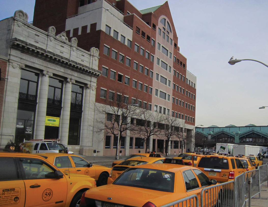
The redevelopment provides opportunities to improve pedestrian conditions along
the Observer Highway and at the entrance of the Hoboken Terminal at Hudson
Place / Warrington Plaza. Some of the existing circulation problems include unsafe
confi guration of the existing location of taxi cabs, jitney bus stops, vehicular drop
off area and pedestrian crossings near the Terminal. Warrington Plaza has limited
pedestrian and bicycle amenities and requires new investments to increase
pedestrian safety near the Terminal.
The Redevelopment Area contains a number of physical development constraints.
A portion of the site contains rail lines and transit operation-related infrastructure
including the existing Terminal Shed and platform tracks near the Terminal Shed.
The Redevelopment Plan includes two developable areas where no NJ Transit rail
tracks and/or historic building currently exist. These sites include approximately 1.8
acres Hudson Place site close to the Terminal Building and approximately 8.3 acre of
developable site along the Observer Highway between Marin Boulevard to the west
and Hudson Street to the east.
Redevelopment Vision and Planning FrameworkThe purpose of the plan was to build consensus around vision for redevelopment
that encourages transit ridership without infringing upon existing and future transit
operations. The plan envisions a transit oriented mixed-use development to advance
environmental, social, and economic sustainability goals of the City and the region.
Through extensive community feedback received during the planning process, review
of existing conditions and input from the city of Hoboken, the following planning and
design principles were identifi ed to guide the Redevelopment Plan.
Development Program and Uses• Provide offi ce uses within a walking distance of the Terminal to reduce parking
need for offi ce employees.
• Encourage mixed-uses with substantial ground level activity to create a vibrant
pedestrian and transit oriented development.
• Create new Public Space and Pedestrian Plazas as focal points within the
redevelopment with community and cultural facilities grouped around them for
active pedestrian use.
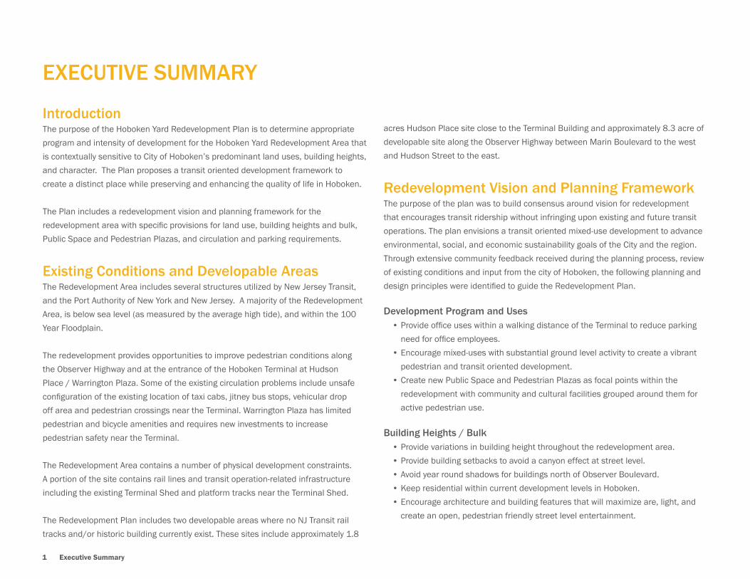
Building Heights / Bulk• Provide variations in building height throughout the redevelopment area.
• Provide building setbacks to avoid a canyon effect at street level.
• Avoid year round shadows for buildings north of Observer Boulevard.
• Keep residential within current development levels in Hoboken.
• Encourage architecture and building features that will maximize are, light, and
create an open, pedestrian friendly street level entertainment.
Hoboken Yard Redevelopment Plan 2
Circulation and Parking• Minimize the need for parking through low parking ratios and designs for a
walkable, intermodal area.
• Minimize the impact of parking areas by using multiple-block parking decks for
greater effi ciency and opportunities for shared parking.
• Encourage designs to create a safer and better place for pedestrians, bicyclists
and transit riders, while improving conditions for those who drive.
View Corridor• Maintain views of the Rail Terminal Lackawanna Clocktower within the existing
and future right of way of Observer Boulevard.
• Provide a visual extension of Hoboken’s street grid southward into the Rail Yards.
Sustainable Development• Maximize use of open space as an essential component of a comprehensive
green infrastructure system.
• Encourage construction of sustainable building design using the existing green
building standard such USGBC’s LEED and/or Living Building Challenge.
• Emphasize the need for fl ood remediation features in green building design.
• Encourage the use of high-quality building materials so as to minimize noise and
other quality of life impacting factors, so as to create grade A offi ce spaces and
less transient prone residential spaces.
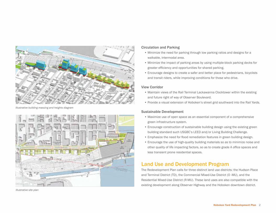
Land Use and Development ProgramThe Redevelopment Plan calls for three distinct land use districts: the Hudson Place
and Terminal District (TD), the Commercial Mixed-Use District (O -MU), and the
Residential Mixed-Use District (R-MU). These land uses are also compatible with the
existing development along Observer Highway and the Hoboken downtown district.
Illustrative building massing and heights diagram
Illustrative site plan

3 Executive Summary
The Hudson Place and Terminal District (TD) includes the historic Terminal and
its facilities along with the Hudson Place redevelopment site located at Hudson
Street and Hudson Place. The TD district serves as a gateway to Hoboken for
residents, visitors, commuters, workers and shoppers. The district will include offi ce
and transportation related uses along with ground fl oor retail uses within the close
proximity of the terminal facilities.
The Commercial Mixed-Use District (C-MU) is located along the proposed Observer
Boulevard between Hudson Street and Park Avenue. C-MU is envisioned as a transit
oriented offi ce and commercial development within a walking distance of the
Terminal building.
The Residential Mixed-Use District (R-MU) is located along the proposed Observer
Boulevard, toward the west side of the Redevelopment Area between Park Avenue
and Marin Boulevard. The residential uses are compatible with existing residential
uses on the north side of Observer Highway. These uses are closer to the transit
station and offi ce-mixed use district to provide 24/7 pedestrian activity along the
proposed Observer Boulevard.
Height and Bulk RequirementsThe Redevelopment Plan provides building height and bulk requirements for all new
structures within the Redevelopment Area. Height and bulk requirements are derived
to avoid canyon effect along Observer Highway and Hudson Place with variation in
building heights.
Height and bulk requirements are provided for each of the three land use districts.
The overall FAR for the redevelopment is 4.56 to maximize the site’s potential for
mixed-use redevelopment and maintain an intensity of use that is consistent with the
existing character and scale of Hoboken. All regulations and setbacks are based on
the future Observer Boulevard right-of-way confi guration recommended in the plan.
Open Space RequirementsThe Redevelopment Plan provides a open space framework to increase the amount
and quality of public space for existing and new residents of Hoboken. The Plan
allows following types of public spaces within the Redevelopment Area:
• Pedestrian Plaza at Hudson Place / Warrington Plaza
• Piazza
Illustrative View looking West at Hudson Place (Site#8/ Site#8A)
Illustrative Rendering of Residential Mixed-Use District along Proposed Observer Boulevard
Hoboken Yard Redevelopment Plan 4
• Street Plazas / Shared Spaces
• Marin Boulevard / Henderson Gateway
• Green Roofs
The Redevelopment Plan requires a minimum of 4.5 acres of public space within
the Redevelopment Area. The public space shall be accessible at street level with
public amenities including street furnishings such as lighting, landscaping, seating,
and public art. Public Spaces within the Redevelopment Area must also function to
provide green infrastructure and enhance storm water management. The provision
of public space and pedestrian plazas shall comply with these requirements and
will need to be approved by the City of Hoboken in the Redevelopment Agreement
document. A fi nancial open space contribution is required and will be based on a
review by the City of Hoboken of a Redevelopment pro forma and included in the
Redevelopment Agreement.
Circulation and Parking RequirementsThe circulation and parking requirements of the Redevelopment Plan are based
on the Redevelopment Area’s proximity to transit, and are intended to reduce the
need for parking and limit the generation of additional vehicular traffi c. Creating a
vibrant pedestrian environment and an interconnected bicycle network that links
the Terminal with the rest of City is also a major goal of the Plan. The circulation and
parking requirements and improvements described in the Plan will need to be further
evaluated for traffi c operations, capacity of the existing roads, etc. Final circulation
and parking plans for the Redevelopment Area will need to be approved by the City of
Hoboken in the Redevelopment Agreement document. The improvements identifi ed
to be necessary to accommodate future traffi c impacts will be required and must be
approved by the City of Hoboken in the Redevelopment Agreement document.
Infrastructure RequirementsThe Redevelopment Area will connect to the existing utilities infrastructure; including
water, sewer, electricity and natural gas. An analysis of the capacity of existing
infrastructure that will be necessary to accommodate the redevelopment will be
required at the design phase. All improvements or expansion identifi ed as necessary
to accommodate proposed development will be required and will need to be approved
by the City of Hoboken in the Redevelopment Agreement document.
Sustainable DesignRedevelopment within the area provides opportunities to integrate sustainable
site design and building design components. Inclusion of such sustainable design
techniques are highly recommended as part of the redevelopment. Inclusion of such
environmentally sustainable site plan and building design methods and techniques
will reduce the additional demand on existing infrastructure and resources as well
as provide life cycle cost benefi ts to the developer. Some of the recommended
sustainable design methods recommended in the Plan include:
• Use of USGBC’s LEED ND or Sustainable Sites Initiative for green neighborhood
design for the entire Redevelopment Area.
• Construction of a minimum LEED Silver or higher standard for all major buildings
within the Redevelopment Area.
• Inclusion of best management practices and green infrastructure techniques
such as rain gardens, bio-swales, green roofs etc. to manage storm water.
• Use of rainwater and/or greywater capture, retention and reuse system.
• Focus on techniquest that will mitigate and prevent further stresses on the City’s
stormwater systems.
Affordable HousingIt is the goal of the Redevelopment Plan to assure that the Project provides for an
appropriate amount of affordable housing to maintain Hoboken’s diversity and in
accordance with applicable law. The implementation the inclusionary affordable
housing element of this Redevelopment Plan will be further addressed in the
Redevelopment Agreement to be entered into between the City of Hoboken and
the redeveloper. At a minimum, the Redevelopment Agreement shall require that
the redeveloper will provide for a minimum of ten percent (10%) of all units within a
development project as affordable.
ConclusionThe Redevelopment Plan provides a framework to accommodate a mixed-use
development that is compatible with the character of Hoboken and complements
existing development across Observer Highway and downtown Hoboken.
The development framework provides fl exibility to incorporate transit-related
improvements planned by NJ Transit independent of the Redevelopment Plan.
5 Introduction

Hoboken Yard Redevelopment Plan 6
1 Introduction

7 Introduction
1.0 INTRODUCTIONThis document is the Hoboken Yard Redevelopment Plan (Redevelopment Plan) for the City of Hoboken, New Jersey. The Redevelopment Plan is prepared pursuant to the
State’s Local Redevelopment and Housing Law (LRHL) (under N.J.S.A. 40A:12A) for the Hoboken Yard Redevelopment Area (Redevelopment Area) located in the southeastern
portion of the City of Hoboken. The redevelopment area was deemed an “area in need of redevelopment” per the LRHL and adopted by the City of Hoboken based on the
fi ndings of the redevelopment study titled “Redevelopment Study for the Hoboken Terminal and Yard” prepared by Phillips Preiss Shapiro Associates, Inc. in November 2006.
The City of Hoboken hired Wallace Roberts Todd (WRT) in April 2011 to assist the City Council to prepare the Redevelopment Plan.
Existing view looking east along Observer Highway
1.1 Redevelopment Plan PurposeThe purpose of the Redevelopment Plan is to:
• Determine appropriate program and level of development for the Redevelopment
Area that is contextually sensitive to City of Hoboken’s predominant land uses,
building heights, and character.
• Develop a distinct place that preserves and enhances the quality of life in
Hoboken that integrates and reinforces Hoboken’s image through transit
oriented and economic development, while deferring to NJ Transit in the exercise
of its core public transportation functions.
• Build consensus around vision for redevelopment that encourages transit
ridership without infringing upon existing and future transit operations.
• Advance environmental, social, and economic sustainability goals of the City and
the region.
Hoboken Yard Redevelopment Plan 8
Hudson Place
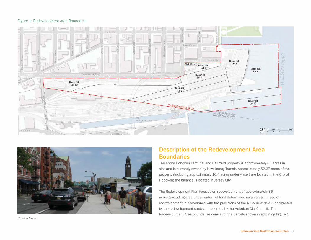
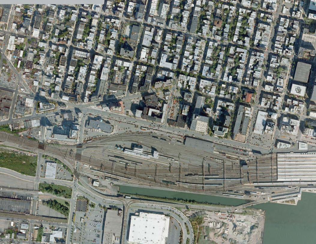
Description of the Redevelopment Area BoundariesThe entire Hoboken Terminal and Rail Yard property is approximately 80 acres in
size and is currently owned by New Jersey Transit. Approximately 52.37 acres of the
property (including approximately 16.4 acres under water) are located in the City of
Hoboken; the balance is located in Jersey City.
The Redevelopment Plan focuses on redevelopment of approximately 36
acres (excluding area under water), of land determined as an area in need of
redevelopment in accordance with the provisions of the NJSA 40A: 12A-5 designated
by the redevelopment study and adopted by the Hoboken City Council. The
Redevelopment Area boundaries consist of the parcels shown in adjoining Figure 1.
Figure 1: Redevelopment Area Boundaries
9 Introduction
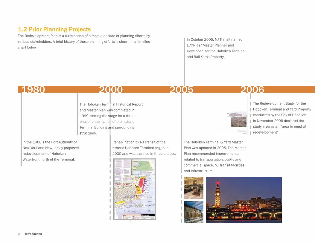
1.2 Prior Planning ProjectsThe Redevelopment Plan is a culmination of almost a decade of planning efforts by
various stakeholders. A brief history of these planning efforts is shown in a timeline
chart below:
In the 1980’s the Port Authority of
New York and New Jersey proposed
redevelopment of Hoboken
Waterfront north of the Terminal.
The Hoboken Terminal Historical Report
and Master plan was completed in
1999, setting the stage for a three
phase rehabilitation of the historic
Terminal Building and surrounding
structures.
Rehabilitation by NJ Transit of the
historic Hoboken Terminal began in
2000 and was planned in three phases.
The Hoboken Terminal & Yard Master
Plan was updated in 2005. The Master
Plan recommended improvements
related to transportation, public and
commercial space, NJ Transit facilities
and Infrastructure.
In October 2005, NJ Transit named
LCOR as “Master Planner and
Developer” for the Hoboken Terminal
and Rail Yards Property.
1980 2000 2005The Redevelopment Study for the
Hoboken Terminal and Yard Property
conducted by the City of Hoboken
in November 2006 declared the
study area as an “area in need of
redevelopment”.
Redevelopment Study for the
of the City of Hoboken
Hoboken Terminal & Yard
Prepared for the City of Hoboken Planning Board
Phillips Preiss Shapiro Associates, Inc.
Planning & Real Estate Consultants
November 2006
2006
Hoboken Yard Redevelopment Plan 10
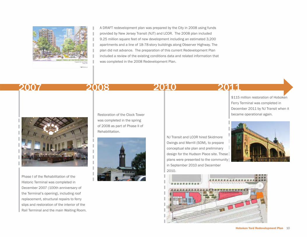
Phase I of the Rehabilitation of the
Historic Terminal was completed in
December 2007 (100th anniversary of
the Terminal’s opening), including roof
replacement, structural repairs to ferry
slips and restoration of the interior of the
Rail Terminal and the main Waiting Room.
Restoration of the Clock Tower
was completed in the spring
of 2008 as part of Phase II of
Rehabilitation.
A DRAFT redevelopment plan was prepared by the City in 2008 using funds
provided by New Jersey Transit (NJT) and LCOR. The 2008 plan included
9.25 million square feet of new development including an estimated 3,200
apartments and a line of 18-78-story buildings along Observer Highway. The
plan did not advance. The preparation of this current Redevelopment Plan
included a review of the existing conditions data and related information that
was completed in the 2008 Redevelopment Plan.
$115 million restoration of Hoboken
Ferry Terminal was completed in
December 2011 by NJ Transit when it
became operational again.
NJ Transit and LCOR hired Skidmore
Owings and Merrill (SOM), to prepare
conceptual site plan and preliminary
design for the Hudson Place site. These
plans were presented to the community
in September 2010 and December
2010.
2007 2008 2010 2011

11 Background and Existing Conditions

Hoboken Yard Redevelopment Plan 12
2 Background & Existing Conditions

13 Background and Existing Conditions
2.0 BACKGROUND & EXISTING CONDITIONS
2.1 Context
Multi-modal Transportation TerminalHoboken Terminal is the largest multi-modal Transportation hub in the NY metro
area with approximately 50,000 commuters passing through Hoboken Terminal
on a typical weekday morning. Several rail lines including the Port Authority Trans-
Hudson line (PATH), NJ Transit, and Hudson – Bergen Light Rail (HBLR) serve the
Terminal connecting northern and central New Jersey to New York. NJ Transit
operates bus routes from the Terminal to Hoboken, New York City, Newark and other
cities in northern and central New Jersey counties. NY Waterways operates Ferry
service connecting Hoboken to New York City. The Redevelopment Area’s regional
transportation accessibility is shown in Figure 3 – Regional Transit Connections.
The redevelopment area provides signifi cant opportunities to create a pedestrian
accessible Transit Oriented Development (TOD) taking advantage of the inter-modal
transit connections from Hoboken to the NJ-NY region.
Figure 2: Existing Building Heights
Surrounding Land Uses and Building HeightsObserver Highway and Hudson Place border the northern edge of the Redevelopment
Area. The north side of Observer Highway is characterized by a mix of uses; including
commercial, residential, and offi ce buildings ranging in height from three to fi fteen
stories. The properties north of Observer Highway, west of Garden Street are
characterized by primarily high-density residential uses.
North of Hudson Place is Hoboken’s downtown core. The north side of Hudson Place
is characterized by fi ve to twelve story mixed-use buildings; including mainly offi ce
and retail space, with some residential uses as well. Retail space in the area consists
mostly of ground fl oor restaurants and commuter services such as news stands along
Hudson Place facing the Terminal building. Figure 2 depicts the existing range of
building heights that create the context around the redevelopment area.
LegendApproximate number of stories
#

Hoboken Yard Redevelopment Plan 14
Map Courtesy of City of Hoboken 2008 Draft Redevelopment Plan Prepared by FX Fowle
Figure 3: Regional Transit Connections

15 Background and Existing Conditions
Development ContextThe Redevelopment Area abuts other existing designated redevelopment areas
within the City as shown in Figure 4. Directly across Observer Highway from the
Redevelopment Area between Park Avenue and Garden Street is the Public Works
Municipal Garage Redevelopment Area (DPW). The redevelopment plan approved for
the DPW area permits up to 240 multi-family residential units with up to 10,000 to
15,000 SF of ground fl oor retail along Observer Highway.
The triangular portion of the property between Observer Highway and Newark Street
known as the Neumann Leather factory complex was designated an Area in Need of
Rehabilitation in 2011.
The area along the north side Observer Highway between Park Avenue and
Bloomfi eld Street is the Observer Highway Redevelopment Area (OBS). This area was
Figure 4: Hoboken Redevelopment Areas
Proposed Mixed -Use Building at Public Works Garage Site Redevelopment Area (Image courtsey: S.Hekemian Group)

Hoboken Yard Redevelopment Plan 16
Figure 5: South Waterfront Redevelopment Area
designated as blighted in accordance with the Neighborhood Development Program
Renewal Area in 1972. A plan for the area was adopted in 1988, and has since been
built out.
The South Waterfront Redevelopment Area (WAT) is located to the north of the
Hoboken Terminal, east of River Street. The redevelopment program for this area
includes about 2.3 million square feet of development on approximately 48.9 acres
of waterfront land. The development contains three offi ce towers of about 14 stories
totaling approximately 1.45 million square feet (the fi nal tower - Waterfront Corporate
Center III, is expected to open in 2014), and a 280 feet, 245,000 square feet W
Hotel with 265 guest rooms and 40 upper fl oor condominium apartment units, a 526
unit luxury rental building and a 10 acre park. The plan was adopted in 1989 and
construction commenced in 2000.
Proposed Waterfront Corporate Center III at South Waterfront Redevelopment Area (Image courtsey: SJP Properties / City of Hoboken)
17 Background and Existing Conditions
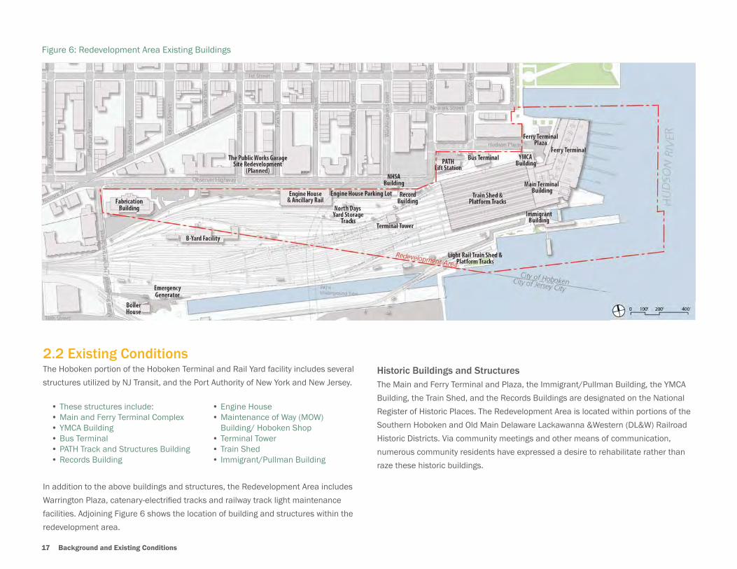
2.2 Existing ConditionsThe Hoboken portion of the Hoboken Terminal and Rail Yard facility includes several
structures utilized by NJ Transit, and the Port Authority of New York and New Jersey.
• These structures include:• Main and Ferry Terminal Complex• YMCA Building• Bus Terminal• PATH Track and Structures Building• Records Building
• Engine House• Maintenance of Way (MOW) Building/ Hoboken Shop• Terminal Tower• Train Shed• Immigrant/Pullman Building
In addition to the above buildings and structures, the Redevelopment Area includes
Warrington Plaza, catenary-electrifi ed tracks and railway track light maintenance
facilities. Adjoining Figure 6 shows the location of building and structures within the
redevelopment area.
Historic Buildings and StructuresThe Main and Ferry Terminal and Plaza, the Immigrant/Pullman Building, the YMCA
Building, the Train Shed, and the Records Buildings are designated on the National
Register of Historic Places. The Redevelopment Area is located within portions of the
Southern Hoboken and Old Main Delaware Lackawanna &Western (DL&W) Railroad
Historic Districts. Via community meetings and other means of communication,
numerous community residents have expressed a desire to rehabilitate rather than
raze these historic buildings.
Figure 6: Redevelopment Area Existing Buildings
Hoboken Yard Redevelopment Plan 18
2.3 Redevelopment Area Site Conditions and Constraints
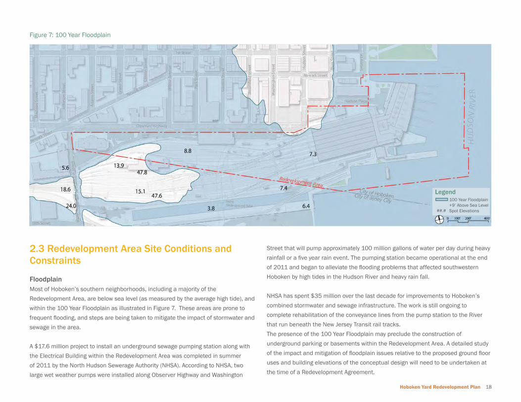
FloodplainMost of Hoboken’s southern neighborhoods, including a majority of the
Redevelopment Area, are below sea level (as measured by the average high tide), and
within the 100 Year Floodplain as illustrated in Figure 7. These areas are prone to
frequent fl ooding, and steps are being taken to mitigate the impact of stormwater and
sewage in the area.
A $17.6 million project to install an underground sewage pumping station along with
the Electrical Building within the Redevelopment Area was completed in summer
of 2011 by the North Hudson Sewerage Authority (NHSA). According to NHSA, two
large wet weather pumps were installed along Observer Highway and Washington
Street that will pump approximately 100 million gallons of water per day during heavy
rainfall or a fi ve year rain event. The pumping station became operational at the end
of 2011 and began to alleviate the fl ooding problems that affected southwestern
Hoboken by high tides in the Hudson River and heavy rain fall.
NHSA has spent $35 million over the last decade for improvements to Hoboken’s
combined stormwater and sewage infrastructure. The work is still ongoing to
complete rehabilitation of the conveyance lines from the pump station to the River
that run beneath the New Jersey Transit rail tracks.
The presence of the 100 Year Floodplain may preclude the construction of
underground parking or basements within the Redevelopment Area. A detailed study
of the impact and mitigation of fl oodplain issues relative to the proposed ground fl oor
uses and building elevations of the conceptual design will need to be undertaken at
the time of a Redevelopment Agreement.
Figure 7: 100 Year Floodplain
Legend
##.#
100 Year Floodplain+9’ Above Sea LevelSpot Elevationsp
19 Background and Existing Conditions
Environmental Conditions A detailed environmental assessment will be required to ascertain environmental
constraints and mitigation measures that will be required to implement changes to
the existing land uses and zoning of the Redevelopment Area.
A preliminary Environmental Assessment (Phase I and Phase II Preliminary
Assessment), of the Redevelopment Area was conducted in 2008 as part of the
2008 Redevelopment Plan. The 2008 Plan document mentions a need to conduct a
Final Environmental Assessment to recommend environmental mitigation measures
suitable to redevelop the site.
InfrastructureTwo large diameter stormwater outfall pipes run beneath the Redevelopment Area in
a north-south direction and discharge into the Long Slip Canal. A PATH tunnel runs
beneath the Redevelopment Area in an east-west direction at Hudson Place and a
north-south direction between Garden and Bloomfi eld Streets. Future redevelopment
will span the underlying infrastructure, including the PATH tunnel.
Potential limits in the capacity of existing water and combined sewer infrastructure
presents the opportunity to incorporate gray water systems into the development
in order to reduce sewer demand. A range of best practices, such as storm water
recycling for irrigation, and green roofs to reduce the discharge of stormwater runoff
and improve water quality will also be desirable.
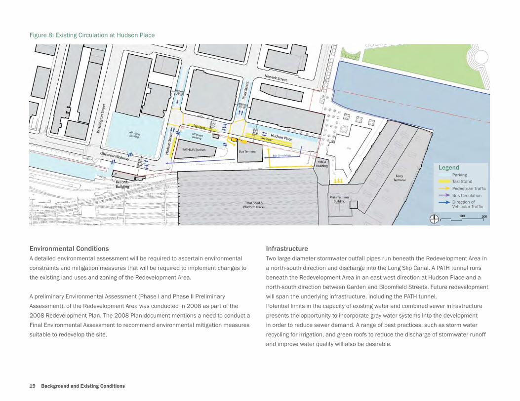
Figure 8: Existing Circulation at Hudson Place
LegendParkingTaxi Stand
Pedestrian Traffi c
Bus CirculationDIrection of Vehicular Traffi c
Hoboken Yard Redevelopment Plan 20
Pedestrian and Vehicular CirculationThe Redevelopment Area along Observer Highway and Hudson Place abuts a majority
of Hoboken’s north-south thoroughfares. The redevelopment of this area provides
opportunities to improve pedestrian conditions along Observer Highway and at the
entrance of the Hoboken Terminal at Hudson Place / Warrington Plaza. Existing
circulation problems include:
• Warrington Plaza has limited pedestrian amenities and requires new investments
to increase safety near the Terminal including signage, streetscape, and lighting
to make the open space more of a community asset.
• Unsafe confi guration of the existing location of taxi cabs, jitney bus stops,
vehicular drop off area and pedestrian crossings near the Terminal. Several
points of confl ict occur between mode transfers and access points in the area.
• Limited bicycle parking facilities in the vicinity of the Terminal and a lack of
bicycle lanes along Observer Highway.
• The Hoboken Terminal and the Redevelopment Area represent a missing link in
the Hudson River Waterfront Walkway, part of the New Jersey State Development
and Redevelopment Plan that calls for public waterfront access from the
Bayonne Bridge to the George Washington Bridge.
The City of Hoboken has received $2 million in federal funding to improve Observer
Highway and $240,000 in federal funding to improve Newark Street between River
Street and Washington Street. The improvements include re-confi guration of the
existing right-of-way of the Observer Highway between Washington Street and Marin
Boulevard to include parking lanes, a turn lane/stripped median and introduction of
a two-way bike/pedestrian path along the southern side of Observer Highway (see
adjoining sections). Safe Streets to Transit funding was also secured for pedestrian
safety improvements in the Hudson Place Area.
Existing East West Section Across Hudson Place
Warrington Plaza
Train ShedBus TerminalHudson Place
Hudson Place
Existing
73’
WB Travel Lane WB Travel Lane EB Travel Lane EB Travel Lane Median Parking Lane Service Rd11.25’ 11’ 11’ 11.25’ 5’ 8’ 14.5’
Sidewalk15’
73’
WB Travel Lane EB Travel Lane Parking Lane Parking LaneTWLTL/Median Buffer Two-Way Bike/Ped Path8’ 12’ 15’ 12’ 8’ 3’ 15’
Sidewalk15’
Existing Observer Highway Right of Way
Proposed Observer Highway Interim Improvements (City of Hoboken)

21 Background and Existing Conditions
1. Hudson Place Site: Approximately 1.81 acre site close to the Terminal Building
and Warrington Plaza at the corner of Hudson Street and Hudson Place. The site
includes the existing YMCA Building and the Bus Terminal. According to NJ Transit’s
public information meetings in September and December of 2010, a new bus
terminal with offi ce space for NJ Transit has been planned at this site. The site
abuts the two staircases that provide access to the underground PATH terminal. The
location of this underground Port Authority owned terminal limits the “terra fi rma”
area for future development at this site.
2. Area along Observer Highway: Approximately 8.35 acres of developable site
along the Observer Highway between Marin Boulevard to the west and Hudson Street
to the east. This area includes the existing Engine House and Fabrication Buildings
that are proposed to be relocated by NJ Transit and a parking area available for use
by commuters and NJ transit employees.
2.4 Physical Constraints & Developable AreasIn addition to some of the site conditions and constraints described above, the
Redevelopment Area contains a number of physical development constraints. A
portion of the site contains rail lines and transit operation-related infrastructure
including the existing Terminal Shed and platform tracks near the Terminal Shed. This
Redevelopment Plan does not permit redevelopment anywhere other than the areas
set forth herewithin.
Figure 9: Opportunities and Constraints Map shows the location of large developable
sites and constraints, including the Hudson Place and Area along Observer Highway.
Only two land areas exist within the Redevelopment Area where no NJ Transit rail
tracks currently exist. These sites include (1) Hudson Place Site and (2) The area
along Observer Highway (Future Observer Boulevard)
Figure 9: Opportunities and Constraints
LegendRedevelopment Area
Existing Open Space
Historic Resources/Landmarks
Major Retail Corridor
Major Transit Hub
Buildable Area
Public Space Opportunity
Gateway Opportunity
Proximity to Washington Street Shopping
Potential Connectionto Waterfront
Potential Connection toSW Rehabilitation Area
Connection to Newport
Ferry Service Moving to Historic Location
Bicycle/Pedestrian Waterfront Walkway
1
2
3
4

Hoboken Yard Redevelopment Plan 22
Figure 10: Developable Areas and Parcels
LegendLimit of Potential Available AreaDevelopment Parcels
LegendLimit of Potential Available AreaDevelopment Parcels
Aerial View of the Redevelopment Area

23 Redevelopment Plan Framework

Hoboken Yard Redevelopment Plan 24
3 Redevelopment Plan Framework

25 Redevelopment Plan Framework
3.0 REDEVELOPMENT PLAN FRAMEWORK
3.1 Planning ProcessTo meet the goals of the Redevelopment Plan, a public participation strategy was
developed at the beginning of the planning process to encourage participation and
gather public feedback and input. The Redevelopment Plan process began in April
2011, and included a number of visioning and consensus building efforts with the
residents of the City of Hoboken and stakeholders including NJ Transit. These efforts
included outreach and community surveys, as well as meetings and presentations.
Public presentations related to the Redevelopment Plan were posted on the City of
Hoboken website along with the project schedule, and announcements of public
meeting dates and locations. A community survey was also posted on the website in
an effort to receive additional comments and feedback regarding the Redevelopment
Plan alternatives. A detailed summary of the planning processes, stakeholder
coordination and public input is provided in Appendix A: Planning Process.
Throughout the planning process, a series of redevelopment and circulation
alternatives were developed. These alternatives represented a development
framework based on the planning and design principles that were developed through
a series of existing conditions analysis, stakeholder input, and community feedback.
The proposed alternatives were based on the development program assumptions,
and take into consideration existing plans for transportation facility and structural
improvements. Each alternative provided the fl exibility to incorporate future transit-
related improvements to be undertaken at the discretion of NJ Transit. A detailed
summary of the Redevelopment Alternatives, as well as revisions based on public
input is provided in Appendix B. A detailed summary of the Circulation Alternatives
are provided in Appendix C.
Focus Group Discussion at Public Meeting #1

Hoboken Yard Redevelopment Plan 26
Development Program and Uses• Provide offi ce uses within a walking distance of the Terminal to reduce parking
need for offi ce employees.
• New development should encourage mixed-uses with substantial ground level
activity to create a vibrant pedestrian oriented development.
• Create new public space and pedestrian plazas as focal points within the
redevelopment with community and cultural facilities grouped around them for
active pedestrian use.
• Encourage, but not require adaptive re-use of the historic building such as the
mezzanine fl oor of the Ferry Terminal and the Records Building.
• Encourage, but not require the continued use of historic and/or noteworthy
buildings, structures, objects, and sites and facilitate their appropriate reuse.
• Encourage, but not require the redevelopment of two Piers south of Ferry
Terminal.
• Encourage notable and progressive architecture.
Sustainable Development• Maximize use of open space as an essential component of a comprehensive
green infrastructure system.
• Encourage construction of sustainable building design using the existing green
building standard such USGBC’s LEED and/or Living Building Challenge.
• Emphasize the need for fl ood remediation features in green building design.
• Encourage the use of high-quality building materials so as to minimize noise and
other quality of life impacting factors, so as to create grade A offi ce spaces and
less transient prone residential spaces.
• Encourage the conservation and effi cient use of natural resources; consideration
of renewable energy systems; and conservation and reuse of water resources.
• Encourage district scale sustainability measures such as central utility corridors
or increasing effi ciencies of scale and conserve natural resources.
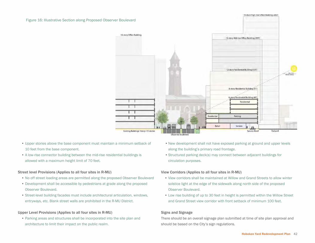
Building Heights / Bulk• Provide variations in building height throughout the redevelopment area.
• Provide building setbacks to avoid a canyon effect at street level.
• Encourage architecture and building features that will maximize air, light, and
create an open, pedestrian friendly street level entertainment.
• Provide perpendicular orientation of higher height buildings to Observer
Boulevard to avoid year round shadows for buildings north of Observer
Boulevard. Also included is a typical section that illustrates this measure for
the winter solstice condition. Figure 16 (see page 42) provides a typical section
along Observer Boulevard that illustrates this measure for the winter solstice
condition.
• Keep residential within current development levels in Hoboken.
Circulation and Parking• Minimize the need for parking through low parking ratios and designs for a
walkable, intermodal area.
• Minimize the impact of parking areas by using multiple-block parking decks for
greater effi ciency and opportunities for shared parking.
• Encourage designs to create a better place for pedestrians, bicyclists and transit
riders, while improving conditions for those who drive.
View Corridor• Maintain views of the Rail Terminal Lackawanna Clocktower within the existing
and future right of way of Observer Boulevard.
• Provide a visual extension of Hoboken’s street grid southward into the Rail Yards.
3.2 Planning and Design PrinciplesThe following planning and design principles are derived from the extensive community feedback received during the planning process, review of existing conditions and
input from the City of Hoboken.

27 Redevelopment Plan Framework
Mixed -Use Development
3.3 Development Program Assumptions
The Redevelopment Plan incorporates the following development program-related
assumptions. These assumptions include:
Mixed-Use Development
• The Redevelopment Plan is based on the exploration a variety of program
combinations to accommodate a mix of uses including residential, commercial,
and offi ce related uses. Public and stakeholder input indicated a need to
accommodate service-oriented retail, live-work places, and community
amenities such as day care, classroom space, public space for theatre ensemble
rehearsals, large public theatre etc. within the Redevelopment Area.
Public Space and Pedestrian Plazas
• The Redevelopment Plan includes strategies to accommodate the design and
development of new parks and additional open space to meet the city’s growing
demand for quality public spaces. The Plan includes public space and pedestrian
plaza program requirements aimed at implementing the City’s open space goals,
particularly related to increased pedestrian safety in the areas surrounding
Hoboken Terminal.
Quality Offi ce Space
• Based on the Redevelopment Area’s location directly adjacent to a major
regional intermodal facility, The Plan includes the provision of Class A offi ce
space with the appropriate scale and fl oor-plate to attract major tenants.
Public Space and Pedestrian Plazas
Mixed - Use Offi ce District
Hoboken Yard Redevelopment Plan 28
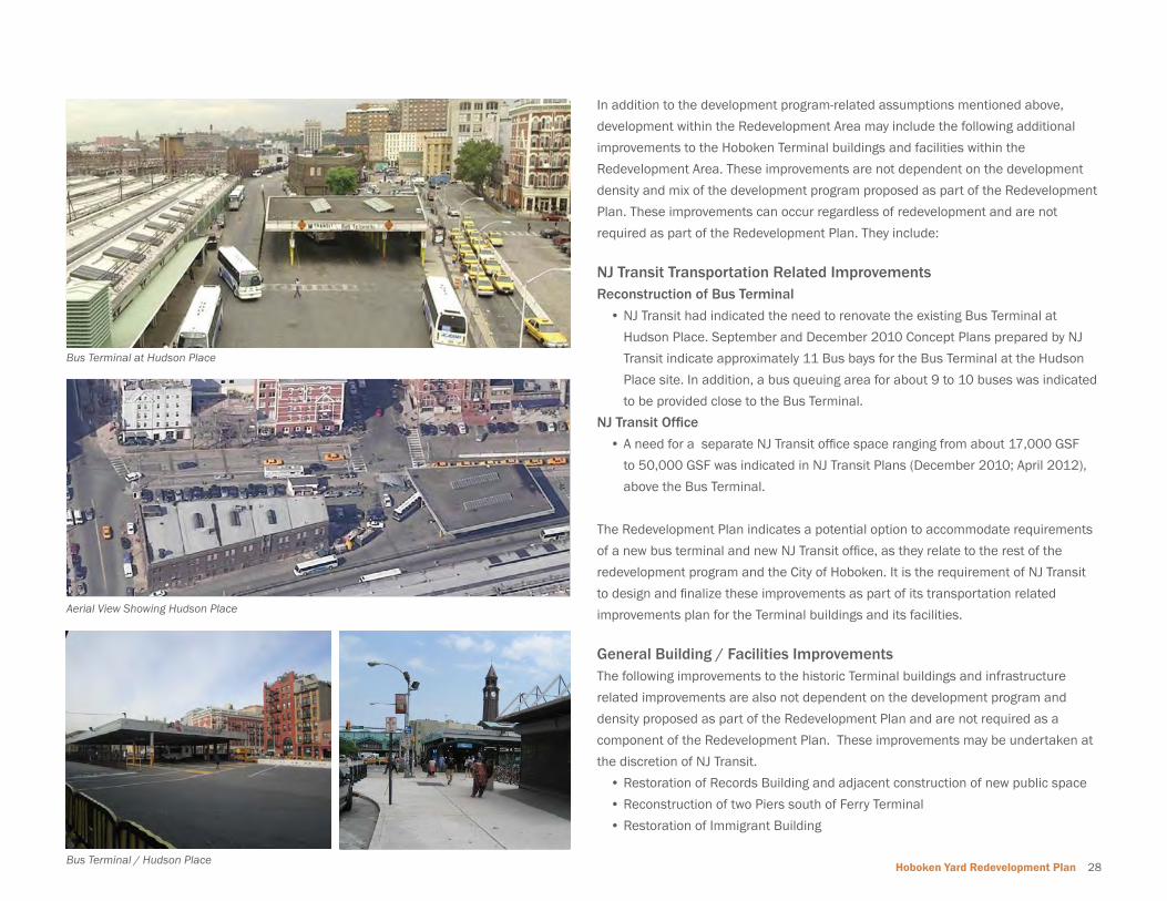
In addition to the development program-related assumptions mentioned above,
development within the Redevelopment Area may include the following additional
improvements to the Hoboken Terminal buildings and facilities within the
Redevelopment Area. These improvements are not dependent on the development
density and mix of the development program proposed as part of the Redevelopment
Plan. These improvements can occur regardless of redevelopment and are not
required as part of the Redevelopment Plan. They include:
NJ Transit Transportation Related ImprovementsReconstruction of Bus Terminal
• NJ Transit had indicated the need to renovate the existing Bus Terminal at
Hudson Place. September and December 2010 Concept Plans prepared by NJ
Transit indicate approximately 11 Bus bays for the Bus Terminal at the Hudson
Place site. In addition, a bus queuing area for about 9 to 10 buses was indicated
to be provided close to the Bus Terminal.
NJ Transit Offi ce
• A need for a separate NJ Transit offi ce space ranging from about 17,000 GSF
to 50,000 GSF was indicated in NJ Transit Plans (December 2010; April 2012),
above the Bus Terminal.
The Redevelopment Plan indicates a potential option to accommodate requirements
of a new bus terminal and new NJ Transit offi ce, as they relate to the rest of the
redevelopment program and the City of Hoboken. It is the requirement of NJ Transit
to design and fi nalize these improvements as part of its transportation related
improvements plan for the Terminal buildings and its facilities.
General Building / Facilities ImprovementsThe following improvements to the historic Terminal buildings and infrastructure
related improvements are also not dependent on the development program and
density proposed as part of the Redevelopment Plan and are not required as a
component of the Redevelopment Plan. These improvements may be undertaken at
the discretion of NJ Transit.
• Restoration of Records Building and adjacent construction of new public space
• Reconstruction of two Piers south of Ferry Terminal
• Restoration of Immigrant Building
Aerial View Showing Hudson Place
Bus Terminal at Hudson Place
Bus Terminal / Hudson Place
29 Redevelopment Plan
Hoboken Yard Redevelopment Plan 30
4 Redevelopment Plan

31 Redevelopment Plan
4.0 REDEVELOPMENT PLANThe Redevelopment Plan provides a framework to accommodate a mixed-use
development that is compatible with the character of Hoboken and complements
existing development across Observer Highway and downtown Hoboken.
The development framework provides fl exibility to incorporate transit-related
improvements planned by NJ Transit independent of the Redevelopment Plan.
4.1 NJ Transit Facilities & OperationsA signifi cant portion of the property within the Redevelopment Area is currently
owned by NJ Transit, an agency of the State which is ultimately responsible for
the administration of New Jersey’s public transportation services, and Hoboken
acknowledges NJ Transit’s authority in that regard. Accordingly, Hoboken intends
to implement the Redevelopment Plan in a manner which promotes Hoboken’s
legitimate local interests under the Redevelopment Law while affording due
deference to NJ Transit as to that agency’s core transit functions. To that end, this
Redevelopment Plan does not purport to independently authorize or prevent any
improvements to any transit facilities owned or operated by NJ Transit, including
Hoboken Terminal, or any other such improvements which would directly infringe
upon NJ Transit’s core transportation functions.
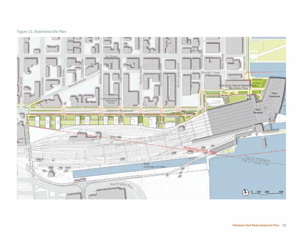
4.2 Vision and Illustrative ConceptThe Redevelopment Plan provides a long-term vision and a development framework
that is contextually sensitive to the City of Hoboken’s predominant land uses, building
heights and character. The Redevelopment Plan envisions a mixed-use development
that refl ects the planning and design principles developed as part of the planning
process. The Redevelopment Plan allows fl exibility for accommodating changing
economic and market conditions. The Illustrative Concept Plan (see Figure 11) shows
articulation of the planning and design principles and requirements described in this
section.
Illustrative View looking West at Hudson Place (Site#8/ Site#8A)
Hoboken Yard Redevelopment Plan 32
Figure 11: Illustrative Site Plan

33 Redevelopment Plan
4.3 Land Use and Development ProgramThe Redevelopment Plan calls for three distinct land use districts: the Hudson
Place and Terminal District (TD), the Commercial Mixed-Use District (C-MU), and the
Residential Mixed-Use District (R-MU). This section describes the permitted uses in
each district. The new uses prescribed in the Redevelopment Area follow the purpose
and intent of the Redevelopment Plan and the planning and design principles. These
land uses are also compatible with the existing development along Observer Highway
and the Hoboken downtown district. Figure 12 shows the proposed land use plan.
Figure 12: Land Use
LegendProposed Land Use Districts
Illustrative Rendering of Residential Mixed-Use District along Proposed Observer Boulevard

Hoboken Yard Redevelopment Plan 34
Figure 13: Illustrative Diagram showing Sample Development Program
LegendOffi ceResidentialCommercial Parking
Development Program Summary

35 Redevelopment Plan
Hudson Place and Terminal District (TD)The TD District includes the historic Terminal and its facilities along with the Hudson
Place redevelopment site located at Hudson Street and Hudson Place. The TD
district serves as a gateway to Hoboken for residents, visitors, commuters, workers
and shoppers. The district includes Warrington Plaza, where retail and cultural uses
are encouraged to enhance the quality of the pedestrian oriented transit plaza. The
following categories of uses are permitted within the TD District to take advantage of
the transit proximity:
Permitted Uses (Group A)
• Offi ce• Transportation Related Uses• Maritime• Hotel• Entertainment• Civic/Institutional• Parks and Plazas• Educational/Schools• Day Care
Permitted Ground Floor Uses (Group B)
• Retail or Commercial Uses
• Restaurants and Bars
• Farmers Markets
• Supermarkets
• Business Services
• Sidewalk Kiosks
• Spaces for Cultural Activities and Civic Uses
• Artists Galleries, Studios and Workshops
• Performing Art Venues
• Health Clubs
Accessory Permitted Uses
• Bicycle shower facilities
• Bicycle storage
• Off Street Parking Facilities
• Off Street Loading
Additional Use Regulations
• Uses within the fi rst fl oor spaces of all buildings in the TD District shall be limited
to those listed in Group B above, except for lobbies and entryways.
• Off street parking facilities are not permitted on the fi rst fl oor.
Commercial Mixed-Use District (C-MU)The Commercial Mixed-Use District (C-MU) is located along the proposed Observer
Boulevard between Hudson Street and Park Avenue. C-MU is envisioned as a transit
oriented development within a walking distance of the Terminal building. The
following categories of uses are permitted within the C-MU District:
Permitted Uses (Group A)
• Offi ce
• Transportation Related Uses
• Hotel
• Entertainment
• Civic/Institutional
• Parks and Plazas
• Educational/Schools
• Day Care
Permitted Ground Floor Uses (Group B)
• Retail or Commercial Uses
• Restaurants and Bars
• Farmers Markets
• Business Services
• Spaces for Cultural Activities and Civic Uses
• Artists Galleries, Studios and Workshops
• Performing Art Centers
• Movie Theatres
• Health Clubs
Hoboken Yard Redevelopment Plan 36
Accessory Permitted Uses
• Bicycle shower facilities
• Bicycle storage
• Off Street Parking Facilities
• Off Street Loading
Additional Use Regulations
• Floor Area shall include a minimum of 70% offi ce uses.
• Uses within the fi rst fl oor spaces of all buildings in the C-MU District shall be
limited to those listed in Group A and B above, except for lobbies and entryways.
• Off street parking facilities are not permitted on the fi rst fl oor fronting Observer
Boulevard.
• Developer must build and provide space/location as noted in Site#1 for
performing arts center within the C-MU District. Design of such space is to be
approved by City of Hoboken in Redevelopment Agreement. The operation of the
performing arts center is not a requirement of the developer.
• Developer must provide approximately 30,000 SF of commercial accelerator
space within Sites #1 and 3.
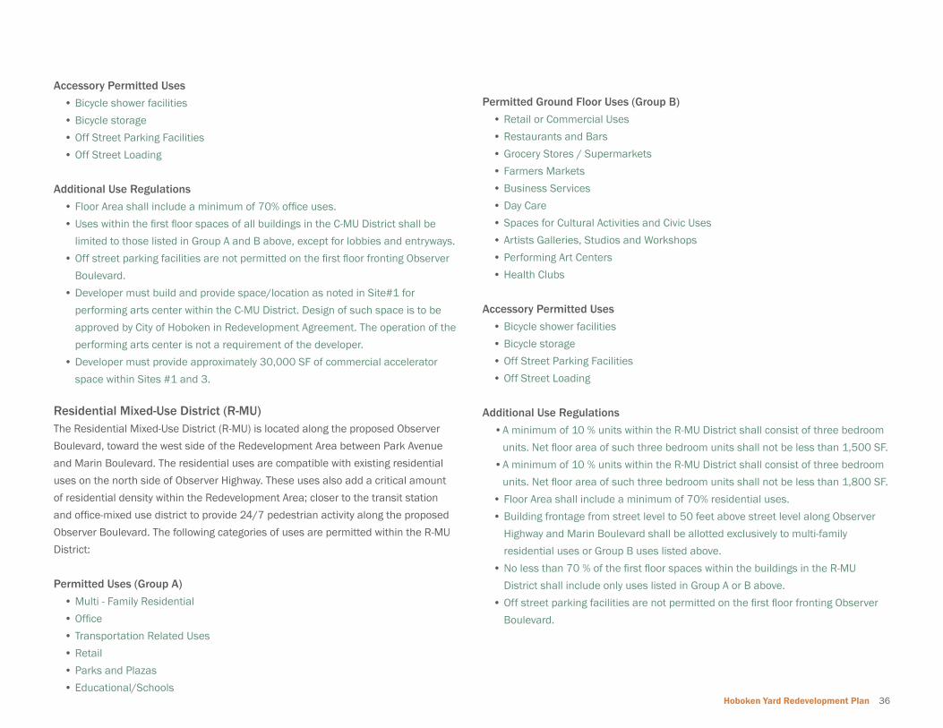
Residential Mixed-Use District (R-MU)The Residential Mixed-Use District (R-MU) is located along the proposed Observer
Boulevard, toward the west side of the Redevelopment Area between Park Avenue
and Marin Boulevard. The residential uses are compatible with existing residential
uses on the north side of Observer Highway. These uses also add a critical amount
of residential density within the Redevelopment Area; closer to the transit station
and offi ce-mixed use district to provide 24/7 pedestrian activity along the proposed
Observer Boulevard. The following categories of uses are permitted within the R-MU
District:
Permitted Uses (Group A)
• Multi - Family Residential
• Offi ce
• Transportation Related Uses
• Retail
• Parks and Plazas
• Educational/Schools
Permitted Ground Floor Uses (Group B)
• Retail or Commercial Uses
• Restaurants and Bars
• Grocery Stores / Supermarkets
• Farmers Markets
• Business Services
• Day Care
• Spaces for Cultural Activities and Civic Uses
• Artists Galleries, Studios and Workshops
• Performing Art Centers
• Health Clubs
Accessory Permitted Uses
• Bicycle shower facilities
• Bicycle storage
• Off Street Parking Facilities
• Off Street Loading
Additional Use Regulations
• A minimum of 10 % units within the R-MU District shall consist of three bedroom
units. Net fl oor area of such three bedroom units shall not be less than 1,500 SF.
• A minimum of 10 % units within the R-MU District shall consist of three bedroom
units. Net fl oor area of such three bedroom units shall not be less than 1,800 SF.
• Floor Area shall include a minimum of 70% residential uses.
• Building frontage from street level to 50 feet above street level along Observer
Highway and Marin Boulevard shall be allotted exclusively to multi-family
residential uses or Group B uses listed above.
• No less than 70 % of the fi rst fl oor spaces within the buildings in the R-MU
District shall include only uses listed in Group A or B above.
• Off street parking facilities are not permitted on the fi rst fl oor fronting Observer
Boulevard.
37 Redevelopment Plan
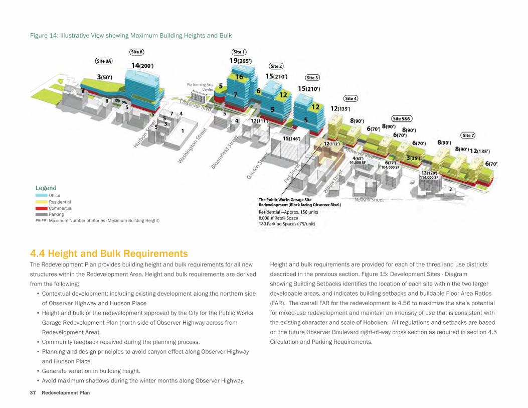
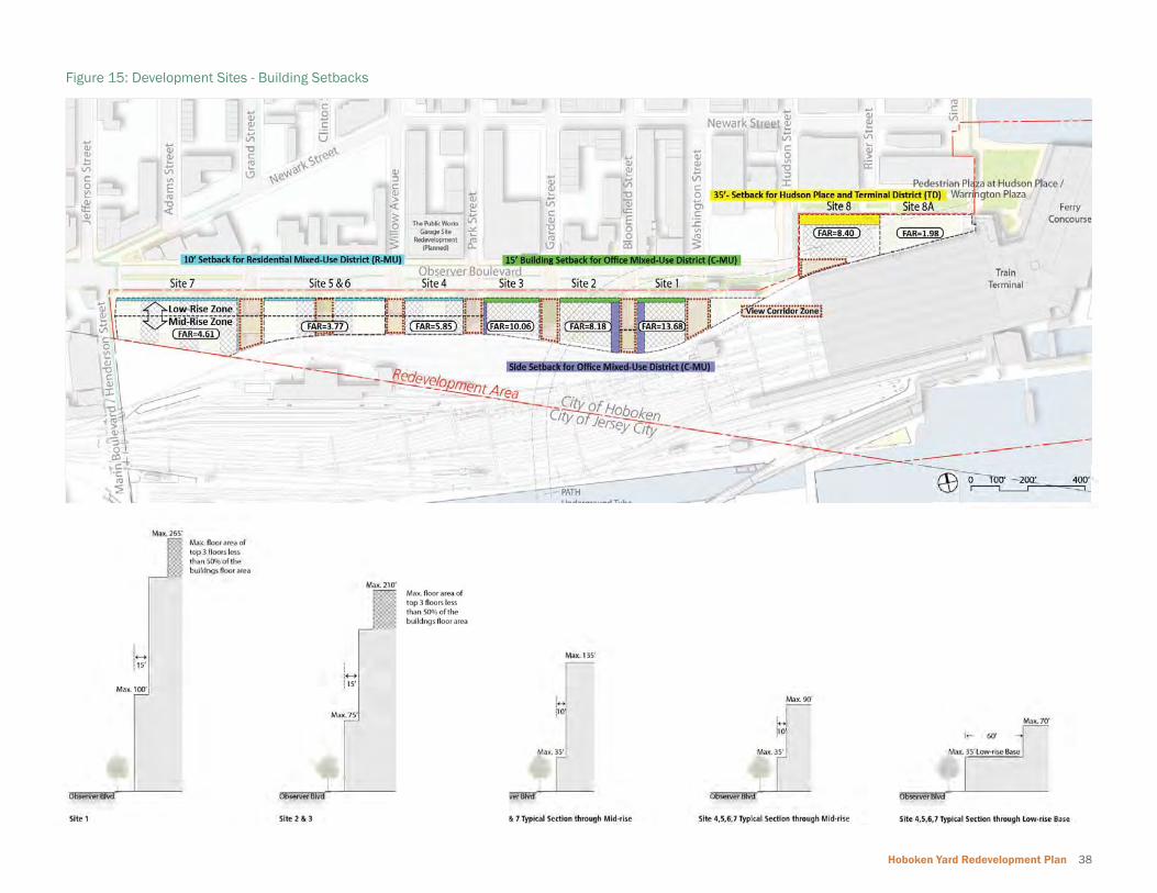
4.4 Height and Bulk RequirementsThe Redevelopment Plan provides building height and bulk requirements for all new
structures within the Redevelopment Area. Height and bulk requirements are derived
from the following:
• Contextual development; including existing development along the northern side
of Observer Highway and Hudson Place
• Height and bulk of the redevelopment approved by the City for the Public Works
Garage Redevelopment Plan (north side of Observer Highway across from
Redevelopment Area).
• Community feedback received during the planning process.
• Planning and design principles to avoid canyon effect along Observer Highway
and Hudson Place.
• Generate variation in building height.
• Avoid maximum shadows during the winter months along Observer Highway.
Height and bulk requirements are provided for each of the three land use districts
described in the previous section. Figure 15: Development Sites - Diagram
showing Building Setbacks identifi es the location of each site within the two larger
developable areas, and indicates building setbacks and buildable Floor Area Ratios
(FAR). The overall FAR for the redevelopment is 4.56 to maximize the site’s potential
for mixed-use redevelopment and maintain an intensity of use that is consistent with
the existing character and scale of Hoboken. All regulations and setbacks are based
on the future Observer Boulevard right-of-way cross section as required in section 4.5
Circulation and Parking Requirements.
Figure 14: Illustrative View showing Maximum Building Heights and Bulk
LegendOffi ceResidentialCommercial Parking Maximum Number of Stories (Maximum Building Height)##(##’)
Performing Arts Center
Hoboken Yard Redevelopment Plan 38
Figure 15: Development Sites - Building Setbacks
39 Redevelopment Plan
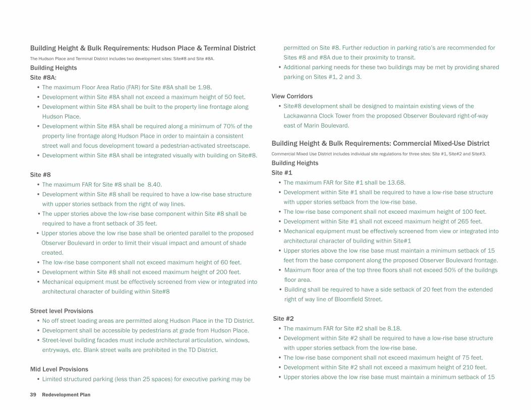
Building Height & Bulk Requirements: Hudson Place & Terminal DistrictThe Hudson Place and Terminal District includes two development sites: Site#8 and Site #8A.
Building Heights
Site #8A:
• The maximum Floor Area Ratio ( FAR) for Site #8A shall be 1.98.
• Development within Site #8A shall not exceed a maximum height of 50 feet.
• Development within Site #8A shall be built to the property line frontage along
Hudson Place.
• Development within Site #8A shall be required along a minimum of 70% of the
property line frontage along Hudson Place in order to maintain a consistent
street wall and focus development toward a pedestrian-activated streetscape.
• Development within Site #8A shall be integrated visually with building on Site#8.
Site #8
• The maximum FAR for Site #8 shall be 8.40.
• Development within Site #8 shall be required to have a low-rise base structure
with upper stories setback from the right of way lines.
• The upper stories above the low-rise base component within Site #8 shall be
required to have a front setback of 35 feet.
• Upper stories above the low rise base shall be oriented parallel to the proposed
Observer Boulevard in order to limit their visual impact and amount of shade
created.
• The low-rise base component shall not exceed maximum height of 60 feet.
• Development within Site #8 shall not exceed maximum height of 200 feet.
• Mechanical equipment must be effectively screened from view or integrated into
architectural character of building within Site#8
Street level Provisions
• No off street loading areas are permitted along Hudson Place in the TD District.
• Development shall be accessible by pedestrians at grade from Hudson Place.
• Street-level building facades must include architectural articulation, windows,
entryways, etc. Blank street walls are prohibited in the TD District.
Mid Level Provisions
• Limited structured parking (less than 25 spaces) for executive parking may be
permitted on Site #8. Further reduction in parking ratio’s are recommended for
Sites #8 and #8A due to their proximity to transit.
• Additional parking needs for these two buildings may be met by providing shared
parking on Sites #1, 2 and 3.
View Corridors
• Site#8 development shall be designed to maintain existing views of the
Lackawanna Clock Tower from the proposed Observer Boulevard right-of-way
east of Marin Boulevard.
Building Height & Bulk Requirements: Commercial Mixed-Use DistrictCommercial Mixed Use District includes individual site regulations for three sites: Site #1, Site#2 and Site#3.
Building Heights
Site #1
• The maximum FAR for Site #1 shall be 13.68.
• Development within Site #1 shall be required to have a low-rise base structure
with upper stories setback from the low-rise base.
• The low-rise base component shall not exceed maximum height of 100 feet.
• Development within Site #1 shall not exceed maximum height of 265 feet.
• Mechanical equipment must be effectively screened from view or integrated into
architectural character of building within Site#1
• Upper stories above the low rise base must maintain a minimum setback of 15
feet from the base component along the proposed Observer Boulevard frontage.
• Maximum fl oor area of the top three fl oors shall not exceed 50% of the buildngs
fl oor area.
• Building shall be required to have a side setback of 20 feet from the extended
right of way line of Bloomfi eld Street.
Site #2
• The maximum FAR for Site #2 shall be 8.18.
• Development within Site #2 shall be required to have a low-rise base structure
with upper stories setback from the low-rise base.
• The low-rise base component shall not exceed maximum height of 75 feet.
• Development within Site #2 shall not exceed a maximum height of 210 feet.
• Upper stories above the low rise base must maintain a minimum setback of 15

Hoboken Yard Redevelopment Plan 40
feet from the base component.
• Mechanical equipment must be effectively screened from view or integrated into
architectural character of building within Site#2
• Maximum fl oor area of the top three fl oors shall not exceed 50% of the buildngs
fl oor area.
• Building shall be required along a minimum of 80% of the site#2 frontage
at Observer Highway in order to maintain a consistent street wall and focus
development toward pedestrians in an activated streetscape.
Site #3
• The maximum FAR for Site #3 shall be 10.06.
• Development within Site #3 shall be required to have a low-rise base structure
with upper stories setback from the low-rise base .
• The low-rise base component shall not exceed maximum height of 75 feet.
• Development within Site #3 shall not exceed maximum height of 210 feet.
• Upper stories above the low rise base must maintain a minimum setback of 15
feet from the base component.
• Mechanical equipment must be effectively screened from view or integrated into
architectural character of building within Site#3
• Maximum fl oor area of the top three fl oors shall not exceed 50% of the buildngs
fl oor area.
• Building shall be required along a minimum 80% of the site#3 frontage
at Observer Highway in order to maintain a consistent street wall and focus
development toward pedestrians in an activated streetscape.
• Upper stories above the low rise base of the building shall be required to have a
side setback of 10 feet from the extended right of way line of Park Street.
Additional Height Regulations (Applies to all three sites in C-MU)
• If a development proposal within Sites #1, 2 and 3 demonstrates signifi cant
architectural creativity to reduce negative impacts to light and air and provides
LEED Gold certifi cation for the subject buildings (s), the City of Hoboken
may permit up to two additional stories in a building to be agreed to in
Redevelopment Agreement.
Street level Provisions (Applies to all three sites in C-MU)
• No off street loading areas are permitted along the proposed Observer Boulevard
in the C-MU District.
• Development shall be accessible by pedestrians at grade from Observer
Boulevard.
• Street-level building facades must include architectural articulation, windows,
entryways, etc. Blank street walls are prohibited in the C-MU District.
• In order to maintain the quantity of the public space in the Redevelopment Area,
all buildings must be designed to incorporate piazza at the termini of Hoboken’s
North- South thoroughfares.at Observer Boulevard. These corner piazza may
range in scale from 2,300 to 6,400 square feet.
Upper Level Provisions (Applies to all three sites in C-MU)
• Parking areas and structures shall be incorporated into the site plan and
Aerial View showing Warrington Plaza / Hudson Place
Hudson Place

41 Redevelopment Plan
architecture to limit their impact on the public realm.
• New development shall not have exposed parking at upper levels along the
building’s primary road frontage.
• Structured parking deck(s) may connect between adjacent buildings for
circulation purposes.
View Corridors
Visual connections within the Redevelopment Area shall be maintained to preserve
the character of the adjacent neighborhoods and limit prolonged periods of shadow
along the proposed Observer Boulevard. To meet this goal, breaks in the skyline
following sight lines from the existing street grid called View Corridors must be
established.
• View corridors shall be maintained at Washington, Bloomfi eld and Garden
Streets to allow winter solstice light at the edge of the sidewalk along the north
side of the proposed Observer Boulevard.
• Low rise building of up to 90 feet in height is permitted within the Bloomfi eld
Street view corridor with front setback of minimum 100 feet as part of Site#1
and/or Site#2 development.
• Low rise building of up to 75 feet in height is permitted within the Washington
Street view corridor as part of Site#1 development.
• No building is permitted withn the Garden Street view corridor.
Building Height & Bulk Requirements for Residential Mixed-Use DistrictResidential Mixed Use District includes individual site regulations for three sites: Site #4, Site#5 and Site#6.
Building Heights
Site #4
• The maximum FAR for Site #4 shall be 5.85.
• Development within Site#4 shall have variation in height and bulk. Maximum
built up area of the development shall be 90%.
• Two mid-rise residential buildings within Site #4 are permitted. Mid-rise
residential building closer to Site #3 is permitted with a maximum height of 135
feet. The other residential building shall not exceed maximum height of 90 feet.
• The two mid-rise buildings combined shall have a maximum of 30 % of the
site#4 frontage along Observer Highway.
• Mid-rise residential buildings within Site #4 shall be required to have a low-rise
base.
• The low-rise base component shall not exceed maximum height of 35 feet.
• Upper stories above the base component must maintain a minimum setback of
10 feet from the base component.
• A low rise connector building between the two residential buildings is allowed
with a maximum height limit of 70 feet.
Site #5 and Site#6
• The maximum FAR for Sites #5 and #6 shall be 3.77.
• Development within Sites #5 and 6 shall have variation in height and bulk.
Maximum built up area of the development shall be 90%.
• Two mid-rise residential buildings within Site #5 and 6 are permitted. They shall
not exceed maximum height of 90 feet.
• The two mid-rise buildings combined shall have a maximum of 30% of the
combined Site#5 and Site#6 frontage along Observer Highway.
• Mid-rise residential buildings within Sites #5 and 6 shall be required to have a
low-rise base.
• The low-rise base component shall not exceed maximum height of 35 feet.
• Upper stories above the base component must maintain a minimum setback of
10 feet from the base component.
• A low-rise connector building between the mid-rise residential buildings is
allowed with a maximum height limit of 70 feet.
Site #7
• The maximum FAR for Site #7 shall be 4.61.
• Development within Site #7 shall have variation in height and bulk. Maximum
built up area of the development shall be 95%.
• Three mid-rise residential buildings within Site #7 are permitted.
• A mid rise building closer to Marin Boulevard is permitted with a maximum
height of 135 feet. The other two mid-rise residential buildings
shall not exceed maximum height of 90 feet.
• The three mid-rise buildings combined shall have a maximum of 30 % of the
Site#7 frontage along Observer Highway.
• Mid-rise residential buildings shall be required to have a low-rise base.
• The low-rise base component shall not exceed maximum height of 35 feet
Hoboken Yard Redevelopment Plan 42
• Upper stories above the base component must maintain a minimum setback of
10 feet from the base component.
• A low-rise connector building between the mid-rise residential buildings is
allowed with a maximum height limit of 70 feet.
Street level Provisions (Applies to all four sites in R-MU)
• No off street loading areas are permitted along the proposed Observer Boulevard
• Development shall be accessible by pedestrians at grade along the proposed
Observer Boulevard.
• Street-level building facades must include architectural articulation, windows,
entryways, etc. Blank street walls are prohibited in the R-MU District.
Upper Level Provisions (Applies to all four sites in R-MU)
• Parking areas and structures shall be incorporated into the site plan and
architecture to limit their impact on the public realm.
• New development shall not have exposed parking at ground and upper levels
along the building’s primary road frontage.
• Structured parking deck(s) may connect between adjacent buildings for
circulation purposes.
View Corridors (Applies to all four sites in R-MU)
• View corridors shall be maintained at Willow and Grand Streets to allow winter
solstice light at the edge of the sidewalk along north side of the proposed
Observer Boulevard.
• Low rise building of up to 30 feet in height is permitted within the Willow Street
and Grand Street view corridor with front setback of minimum 100 feet.
Signs and Signage
There should be an overall signage plan submitted at time of site plan approval and
should be based on the City’s sign regulations.
Figure 16: Illustrative Section along Proposed Observer Boulevard

43 Redevelopment Plan
4.5 Public Space and Pedestrial Plaza RequirementsThe Redevelopment Plan provides a public space and pedestrian plaza framework
to increase the amount and quality of public space for existing and new residents
of Hoboken. This chapter governs all public space within the Redevelopment Area.
Figure 17 shows the types public spaces included in the Redevelopment Plan. They
include:
• Pedestrian Plaza at Hudson Place / Warrington Plaza
• Piazza
• Street Plazas / Shared Spaces
• Marin Boulevard / Henderson Gateway
• Green Roofs
General ProvisionsThe Redevelopment Plan requires a minimum of 4.5 acres of public space and
pedestrian plazas within the Redevelopment Area. The Plan shows a total of 5.63
acres of public space including the pedestrian plaza at Hudon Place. The public
space shall be publicly accessible at street level with public amenities including
street furnishings such as lighting, landscaping, seating, and public art. Public
Open Spaces within the Redevelopment area must also function to provide green
infrastructure and enhance storm water management. The provision of public
spaces shall comply with these requirements and will need to be approved by the
City of Hoboken in the Redevelopment Agreement document. A fi nancial open space
contribution is required and will be based on a review by the City of Hoboken of a
Redevelopment pro forma and included in the Redevelopment Agreement.
Figure 17: Public Space and Pedestrian Plazas
Legend
Marin Blvd/ Henderson Gateway
PiazzaStreet Plazas/Shared Space
Southside Sidewalk/Bike Lane
Warrington Plaza
Green Roofs
Pedestrian Plaza at Hudson Place

Hoboken Yard Redevelopment Plan 44
Pedestrian Plaza at Hudson Place / Warrington PlazaA pedestrian plaza is required at Hudson Place from Hudson Street to Warrington
Plaza, envisioned as a public open space and intermodal gateway to Hoboken.
Construction of this pedestrian plaza may require the re-confi guration of existing taxi
stands, jitney bus drop off and pick up areas, and vehicular drop off areas. Circulation
alternatives have been developed as part of the redevelopment planning process,
and have been included in Appendix C. Redesign of the pedestrian plaza will need to
be approved by the City of Hoboken at the time of Redevelopment Agreement. Final
plans for the plaza shall include the provision of a safe pedestrian zone that connects
with various modes of transit, bicycle lanes and bicycle storage and shower facilities.
Improvements to Hudson Place and Warrington Plaza shall be implemented at the
time of development of Site #8 (Hudson Place Site).
PiazzaA series of piazza or smaller plazas are required at mid-block or corner locations of
the redevelopment along Observer Highway. Each piazza is required to be a minimum
of 2,500 SF with appropriate landscaping and public amenities.
Street Plazas / Shared SpacesPedestrian oriented street plazas or shared spaces are required as part of the
Redevelopment Plan. Recommended locations include Grand Street, Willow
Street, Park Avenue, Garden Street and Bloomfi eld Streets. These plazas are also
recommended to indicate a visual extension of Hoboken’s Street grid southward
into the Rail Yards. This will ensure light at regular intervals along Observer Highway
and break the skyline. The street plazas serve as pedestrian drop off areas with
pedestrian oriented landscaping. These plazas will be anchored by ground level retail
uses and serve as entry points for the parking garages and service access behind
buildings.
Marin Boulevard / Henderson GatewayAn open space is required at the development site at the corner of Marin Boulevard /
Henderson Street and Observer Highway. The open space will act as a gateway space
into Hoboken.
Green RoofsGreen roofs are required for large roof buildings to reduce stormwater runoff by
limiting the amount of impervious surface throughout the Redevelopment Area.
These roofs may also serve as additional open space, and they are effective in
reducing the heat island effect. The location and design of the green roof facilities will
need to be approved by the City of Hoboken in a Redevelopment Agreement.
PHOTO
PHOTO
PHOTO
PHOTO
Pedestrian Plaza
Shared Spaces
Piazza
Boulevard

45 Redevelopment Plan
4.6 Circulation and Parking RequirementsThe circulation and parking requirements of the Redevelopment Plan are based
on the Redevelopment Area’s proximity to transit, and are intended to reduce the
need for parking and limit the generation of additional vehicular traffi c. Creating a
vibrant pedestrian environment and an interconnected bicycle network that links the
Terminal with the rest of city is also a major goal of the Plan. This section provides
a description of the circulation and parking related requirements of the Plan. The
improvements described in this section will need to be further evaluated for traffi c
operations, capacity of the existing roads, etc. Final circulation and parking plans
for the Redevelopment Area will need to be approved by the City of Hoboken in the
Redevelopment Agreement document. The improvements identifi ed to be necessary
to accommodate future traffi c impacts will be required and must be approved by the
City of Hoboken in the Redevelopment Agreement document. As part of the plan
development process, several circulation alternatives were developed and presented
as an opportunity to gain stakeholder and community input. A summary of the
circulation alternative options is provided in Appendix C.
Streets and Traffi c Related ImprovementsA detailed traffi c impact analysis will be required as part of a Redevelopment
Agreement to identify potential traffi c impacts and necessary facility improvements
related to any proposed new development within the Redevelopment Area. Based
on the available documents and studies, the following is a preliminary list of streets
and traffi c related improvements that may be needed as part of redevelopment. The
developer will be responsible for all traffi c related improvements on and off-site that
will be necessary as a result of new development.
• Improvements or redesign of the segment of Marin Boulevard and Henderson
Street between Hoboken and Jersey City.
• Re-confi guration of the fi ve point intersection at Henderson Street/Newark
Avenue/Observer Highway and Jefferson Street intersection. Adjoining Figures
show options or alternatives that were evaluated for this intersection within the
Jersey City/Hoboken Sub-regional Transportation Study (2012), City of Hoboken
Master Plan and in the 2008 Draft Redevelopment Plan prepared by FXFowle.
• Evaluation and reconfi guration of existing traffi c directions for Grove and
Henderson Streets, Newark Avenue and Marin Boulevard.
Existing 5-Way Intersection Reconfi guration Option 1
Reconfi guration Option 2
Reconfi guration Option 3
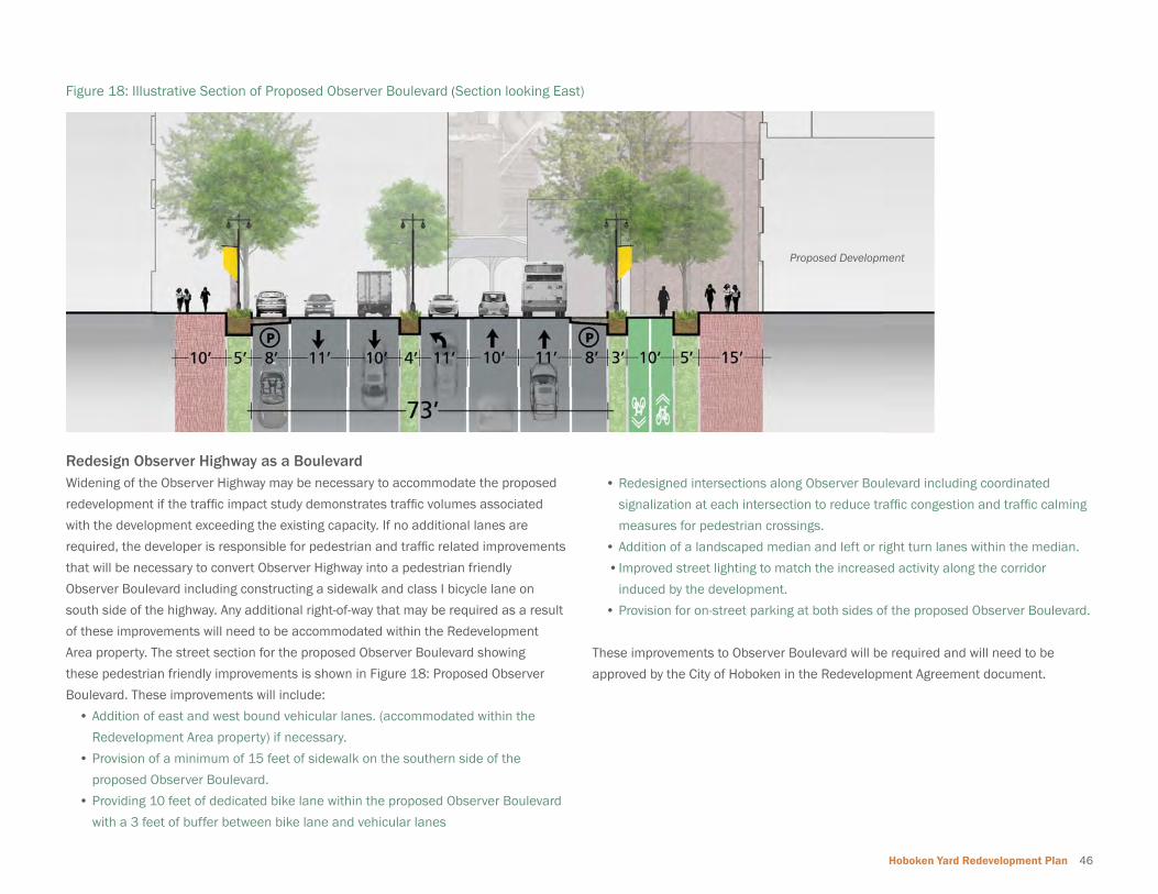
Hoboken Yard Redevelopment Plan 46
Redesign Observer Highway as a BoulevardWidening of the Observer Highway may be necessary to accommodate the proposed
redevelopment if the traffi c impact study demonstrates traffi c volumes associated
with the development exceeding the existing capacity. If no additional lanes are
required, the developer is responsible for pedestrian and traffi c related improvements
that will be necessary to convert Observer Highway into a pedestrian friendly
Observer Boulevard including constructing a sidewalk and class I bicycle lane on
south side of the highway. Any additional right-of-way that may be required as a result
of these improvements will need to be accommodated within the Redevelopment
Area property. The street section for the proposed Observer Boulevard showing
these pedestrian friendly improvements is shown in Figure 18: Proposed Observer
Boulevard. These improvements will include:
• Addition of east and west bound vehicular lanes. (accommodated within the
Redevelopment Area property) if necessary.
• Provision of a minimum of 15 feet of sidewalk on the southern side of the
proposed Observer Boulevard.
• Providing 10 feet of dedicated bike lane within the proposed Observer Boulevard
with a 3 feet of buffer between bike lane and vehicular lanes
• Redesigned intersections along Observer Boulevard including coordinated
signalization at each intersection to reduce traffi c congestion and traffi c calming
measures for pedestrian crossings.
• Addition of a landscaped median and left or right turn lanes within the median.
• Improved street lighting to match the increased activity along the corridor
induced by the development.
• Provision for on-street parking at both sides of the proposed Observer Boulevard.
These improvements to Observer Boulevard will be required and will need to be
approved by the City of Hoboken in the Redevelopment Agreement document.
Figure 18: Illustrative Section of Proposed Observer Boulevard (Section looking East)
Proposed Development

47 Redevelopment Plan
Figure 19: Pedestrian Plaza at Hudson Place / Warrington Plaza
200’100’0
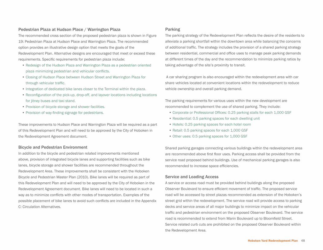
Hoboken Yard Redevelopment Plan 48
Pedestrian Plaza at Hudson Place / Warrington PlazaThe recommended cross section of the proposed pedestrian plaza is shown in Figure
19: Pedestrian Plaza at Hudson Place and Warrington Plaza. The recommended
option provides an illustrative design option that meets the goals of the
Redevelopment Plan. Alternative designs are encouraged that meet or exceed these
requirements. Specifi c requirements for pedestrian plaza include:
• Redesign of the Hudson Plaza and Warrington Plaza as a pedestrian oriented
plaza minimizing pedestrian and vehicular confl icts.
• Closing of Hudson Place between Hudson Street and Warrington Plaza for
through vehicular traffi c.
• Integration of dedicated bike lanes closer to the Terminal within the plaza.
• Reconfi guration of the pick-up, drop-off, and layover locations including locations
for jitney buses and taxi stand.
• Provision of bicycle storage and shower facilities.
• Provision of way-fi nding signage for pedestrians.
These improvements to Hudson Place and Warrington Plaza will be required as a part
of this Redevelopment Plan and will need to be approved by the City of Hoboken in
the Redevelopment Agreement document.
Bicycle and Pedestrian EnvironmentIn addition to the bicycle and pedestrian related improvements mentioned
above, provision of integrated bicycle lanes and supporting facilities such as bike
lanes, bicycle storage and shower facilities are recommended throughout the
Redevelopment Area. These improvements shall be consistent with the Hoboken
Bicycle and Pedestrian Master Plan (2010). Bike lanes will be required as part of
this Redevelopment Plan and will need to be approved by the City of Hoboken in the
Redevelopment Agreement document. Bike lanes will need to be located in such a
way as to minimize confl icts with other modes of transportation. Examples of the
possible placement of bike lanes to avoid such confl icts are included in the Appendix
C: Circulation Alternatives.
ParkingThe parking strategy of the Redevelopment Plan refl ects the desire of the residents to
alleviate a parking shortfall within the downtown area while balancing the concerns
of additional traffi c. The strategy includes the provision of a shared parking strategy
between residential, commercial and offi ce uses to manage peak parking demands
at different times of the day and the recommendation to minimize parking ratios by
taking advantage of the site’s proximity to transit.
A car sharing program is also encouraged within the redevelopment area with car
share vehicles located at convenient locations within the redevelopment to reduce
vehicle ownership and overall parking demand.
The parking requirements for various uses within the new development are
recommended to complement the use of shared parking. They include:
• Corporate or Professional Offi ces: 0.25 parking stalls for each 1,000 GSF
• Residential: 0.5 parking spaces for each dwelling unit
• Hotels: 0.25 parking spaces for each hotel room
• Retail: 0.5 parking spaces for each 1,000 GSF
• Other uses: 0.5 parking spaces for 1,000 GSF
Shared parking garages connecting various buildings within the redevelopment area
are recommended above fi rst fl oor uses. Parking access shall be provided from the
service road proposed behind buildings. Use of mechanical parking garages is also
recommended to increase space effi ciencies.
Service and Loading AccessA service or access road must be provided behind buildings along the proposed
Observer Boulevard to ensure effi cient movement of traffi c. The proposed service
road will be accessed by street plazas recommended as extension of the Hoboken’s
street grid within the redevelopment. The service road will provide access to parking
decks and service areas of all major buildings to minimize impact on the vehicular
traffi c and pedestrian environment on the proposed Observer Boulevard. The service
road is recommended to extend from Marin Boulevard up to Bloomfi eld Street.
Service related curb cuts are prohibited on the proposed Observer Boulevard within
the Redevelopment Area.
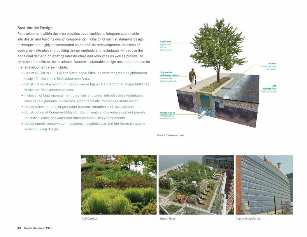
49 Redevelopment Plan
Sustainable DesignRedevelopment within the area provides opportunities to integrate sustainable
site design and building design components. Inclusion of such sustainable design
techniques are highly recommended as part of the redevelopment. Inclusion of
such green site plan and building design methods and techniques will reduce the
additional demand on existing infrastructure and resources as well as provide life
cycle cost benefi ts to the developer. General sustainable design recommendations for
the redevelopment area include:
• Use of USGBC’s LEED ND or Sustainable Sites Initiative for green neighborhood
design for the entire Redevelopment Area.
• Construction of a minimum LEED Silver or higher standard for all major buildings
within the Redevelopment Area.
• Inclusion of best management practices and green infrastructure techniques
such as rain gardens, bio-swales, green roofs etc. to manage storm water.
• Use of rainwater and/or greywater capture, retention and reuse system
• Construction of Common Utility Corridor linking various redevelopment parcels
for chilled water, hot water and other common HVAC components.
• Use of energy conservation measures including solar and bio-thermal systems
within building design.
Green Infrastructure
Green RoofRail Garden Photovoltaic Panels
Hoboken Yard Redevelopment Plan 50
Infrastructure RequirementsThe Redevelopment Area will connect to the existing utilities infrastructure; including
water, sewer, electricity and natural gas. An analysis of the capacity of existing
infrastructure that will be necessary to accommodate the redevelopment will be
required at the design phase. All improvements or expansion identifi ed as necessary
to accommodate proposed development will be required and will need to be
approved by the City of Hoboken in the Redevelopment Agreement document.
A review of the documents available related to utilities infrastructure within the
Redevelopment Area indicates the following issues that need to be evaluated further
prior to redevelopment:
• Replacing the existing combined storm and sanitary sewer system along
Observer Highway within the Redevelopment Area.
• The capacity of the existing sewers, pump stations and treatment facilities to
accommodate an intensifi cation of use within the Redevelopment Area needs to
be verifi ed.
• The adequacy of existing water system infrastructure needs to be verifi ed
to identify any improvements and upgrades necessary to support future
development.
Affordable HousingIt is the goal of the Redevelopment Plan to assure that the Project provides for an
appropriate amount of inclusionary affordable housing, in accordance with applicable
law. The implementation the affordable housing element of this Redevelopment
Plan will be further addressed in the Redevelopment Agreement to be entered into
between the City of Hoboken and the redeveloper. At a minimum, the Redevelopment
Agreement shall require that the redeveloper will provide for a minimum of ten
percent (10%) of all units within a development project as affordable.
Anytime the word “developer” is utilized in this Redevelopment Plan, the same shall
mean the redeveloper or redeveloper(s) that have been designated by the City of
Hoboken in accordance with the Redeveloper Selection Process set forth in Chapter 7
of this Redevelopment Plan.
N.J.S.A. 40A:12A-7(a)(6) and N.J.S.A. 40A:12A-7(a)(7) require that a redevelopment
plan include (i) as of the date of the adoption of the resolution fi nding the area to
be in need of redevelopment, an inventory of all affordable housing units that are
to be removed as a result of implementation of the redevelopment plan; and (ii)
a plan for the provision, through new construction or substantial rehabilitation of
one comparable, affordable replacement housing unit for each affordable housing
unit that has been occupied at anytime within the last 18 months, that is subject
to affordability controls and that is identifi ed as to be removed as a result of the
redevelopment plan.
The following subsections (1) and (2) satisfy the affordable housing “inventory” and
“replacement unit plan” requirements of the law.
(1) Inventory of Affordable Housing
As of February 07, 2007, which is the date upon which the Mayor and Council
of the City of Hoboken adopted a resolution fi nding the subject properties to be
in need of redevelopment, there were no housing units (neither market-rate nor
affordable) in the redevelopment area. The properties within the redevelopment
area have been limited to non-residential uses. Thus, zero (0) affordable housing
units will be removed as a result of this redevelopment plan.
(2) Plan for the Provision of Affordable Replacement Housing
As zero (0) affordable housing units will be removed as a result of this
redevelopment plan (see subsection (1) above), there are no affordable housing
units to be replaced.

51 Introduction

Hoboken Yard Redevelopment Plan 52
5 Plan Relationships

53 Plan Relationships
5.0 PLAN RELATIONSHIPS
5.1 Relationship to City of Hoboken Master PlanThe State of New Jersey’s Local Redevelopment and Housing Law requires that “all
provisions of the Redevelopment Plan shall be either substantially consistent with the
municipal master plan or designed to effectuate the master plan.” (N.J.S.A. 40A:12A-
7.d). This Redevelopment Plan is both substantially consistent with the adopted 2004
Hoboken Master Plan and subsequent Reexamination Reports, as well as designed to
effectuate their goals and objectives. The specifi c goals that the Redevelopment Plan
complies with include:
• Amplify Hoboken’s sense of community, encompassing its social diversity
• Enhance Hoboken’s unique setting as an urban enclave facing New York Harbor
• Improve the appearance of Hoboken’s streets
• Maintain Hoboken’s urbane mix of uses
• Enhance its walkability and pedestrian amenities
• Provide additional open space and recreation facilities
Land Use Element:The Master Plan refers to Hoboken as a “Historic Urban Village,” and recognizes
the Terminal area as the “scene of recent and prospective public and private
investment. Its challenges have to do with balancing its nature as a regional hub and
local amenity.” How this is translated into a Redevelopment Plan for the Terminal
is the key issue. It involves determination of appropriate building heights, massing,
density, and image. Hoboken’s existing character is dense, but with building heights
that hover around six stories. Most of the historic, as well as the newer, buildings in
Hoboken are masonry-not the shiny glass curtain walls conceptually represented in
the Hoboken Terminal Master Plan of 2008.
• Promote and enhance Hoboken’s historic character and design image
• Promote compatibility in scale, density, design and orientation between new and
existing development.
• The redevelopment site plan, square footage and building massing respect
the existing character of the city, while framing views of the historic
Terminal.
• Continue to promote a pedestrian friendly environment
• The walkability of the Redevelopment Area will be enhanced by ensuring an
appropriate mixing uses within the vicinity of the Terminal transportation
hub, as well as enhancing safety across transportation modes, including
pedestrians.
• Enhance physical and visual connections between the waterfront and the rest of
the City; and between the Palisades and City.
• The Redevelopment Plan aims to enhance the underutilized waterfront
within the Redevelopment Area by creating new visual connections and
direct public access.
• Encourage any future redevelopment of existing public buildings for public,
cultural, and civic uses.
• Require buildings to be oriented to the street.
• Provide additional street trees
• The site plan for the Redevelopment Area proposes buildings fronting the
street and framing a high-quality, livable public realm with a streetscape that
includes new trees, and pedestrian and bicycle amenities.
Open Space, Recreation and Conservation ElementThe Open Space, Recreation and Conservation Element recognizes the Lackawanna
Plaza as the only existing Parks and Recreation space within the Redevelopment
Area. The existing Open Space Map also indicates an existing “Waterfront Walkway”
that currently terminates at the northern border of the Redevelopment Area. The
Open Space Concept of the Master Plan proposes a continuation of the “Waterfront
Walkway” through the Terminal and on to Jersey City, as well as a new “Green
Circuit” along Hudson Place and Observer Boulevard that would allow complete
pedestrian circumvention along the city limits of Hoboken. This Redevelopment Plan
is compatible with these proposals, and serves to move the city toward these overall
open space goals.
• Maximize park and recreation opportunities for residents
• The Redevelopment Plan includes 4.5 acres of new public space in addition

Hoboken Yard Redevelopment Plan 54
• The walkability of the Redevelopment Area will be enhanced by ensuring an
appropriate mixing uses within the vicinity of the Terminal transportation
hub, as well as enhancing safety across transportation modes, including
pedestrians.
• Reduce pedestrian confl icts with vehicular traffi c in the Hoboken Terminal Area
• The circulation plan for the Redevelopment Area aims to minimize confl ict
between all modes of transportation, including pedestrian, bicycle, vehicle
and transit.
• Provide additional bicycle storage at Hoboken Terminal and other transit stations
• Explore the creation of a jitney bus system
• Expand the use of existing shuttle systems
• The plans for the Redevelopment Area at Hoboken Terminal are compatible
with the provision of additional bicycle storage, as well as expanded shuttle
and jitney bus systems.
Economic Development ElementThe Hoboken Master Plan recognizes the economic signifi cance of the Terminal, and
the potential to develop the area into more of a destination than it currently is. This
Redevelopment Plan proposes to tap in to the current commuter market for new
business and attraction to the area and enhance the City’s existing retail core areas.
• Encourage additional offi ce space in appropriate locations.
• The Redevelopment Plan is consistent with the Master Plan
recommendation for larger “prime” offi ce space around Hoboken Terminal.
• Encourage a mix of uses in new developments to provide supporting services to
workers and residents.
• Give Preference to small-scale businesses in Hoboken Terminal retail space.
• Promote overnight accommodations.
• Create opportunities for more gathering places
• This Redevelopment Plan includes a mix of uses at a variety of scales to
serve a range of existing and new residents and users of the area. The Plan
is compatible with the Master Plan’s recommendations to give preference
to creating a new connection along the Hudson River waterfront.
• Create a green circuit in the City to link recreational and other amenities
• The streetscape and waterfront plans within the Redevelopment Area are
compatible with the creation of the proposed green circuit and waterfront
walkway.
Circulation and Parking ElementThe Hoboken Terminal Area is a central component of an integrated intermodal,
interstate transportation system, including the Terminal itself, which serves an
estimated 50,000 passengers daily. This Redevelopment Plan is intended to
enhance the overall function of the redevelopment area as a regional resource and
leverage the value of the Terminal as an asset to the residents of Hoboken.
• Enhance walkability throughout the city
Maxwell Place Park, Hoboken
Sinatra Drive / Hudson River Waterfront Walkway, Hoboken

55 Plan Relationships
to small-scale businesses in developed retail space, as well as new
opportunities for overnight accommodation.
Historic Preservation ElementThe Redevelopment Area is designated in its entirety by the Master Plan as an
Eligible Historic District. The Redevelopment Plan supports the preservation of all
buildings within the area that are designated on the National Register of Historic
Places, including;
• Main Terminal, Ferry Terminal and Plaza
• Immigrant/Pullman Building
• YMCA Building
• Train Shed
• Records Buildings
Preserving these structures and enhancing the historic quality of these places as
well as the character of the surrounding community is a central component of the
Redevelopment Plan, specifi cally aiming to effectuate the city’s following goals;
• Safeguard the heritage of Hoboken by preserving buildings and other features
within the City that refl ect elements of its cultural, social, economic, and
architectural history.
• Encourage contemporary building designs for new construction that complement
Hoboken’s historic buildings without mimicking them.
• Encourage the continued use of historic and/or noteworthy buildings, structures,
objects, and sites and facilitate their appropriate reuse.
Housing ElementNew development within the Redevelopment Area will include a mix of housing types
and a range of affordable housing options. It is the goal of the Redevelopment Plan
to assure that the Project provides for an appropriate amount of affordable housing,
in accordance with applicable law. At a minimum, the Redevelopment Agreement
shall require that the redeveloper will provide for a minimum of ten percent (10%)
of all units within a development project as affordable. This requirement, as well as
the overall Plan, move the city toward their goal of a “home for everyone”, specifi cally
aiming to effectuate the city’s following goals;
• Provide diversity in types of housing.
• The Redevelopment Plan includes a range in housing types and prices.
• Provide additional affordable units in new residential developments.
• The Redevelopment Plan requires that a minimum of ten percent (10%) of
new residential units be affordable.
5.2 2010 Master Plan Re-examination ReportThe City completed a reexamination of their adopted Master Plan in 2010 to review
the status of the adopted 2004 plan’s objectives, outline policy changes since its
adoption, and state objectives going forward. Within this context, several policies
related to the Redevelopment Area were reviewed and recommendations proposed
that are consistent with this Redevelopment Plan.
Transportation: Make Hoboken a better place for pedestrians, bicyclists and transit riders, while
Historic Hoboken Terminal & Clock Tower

Hoboken Yard Redevelopment Plan 56
improving conditions for those who drive.
• Make it safer to walk and bike with new facilities intersection improvements, etc.
• Relocate and/or redesign the passenger drop-off area and taxi stand near
the Terminal. The reexamination report indicates that the taxi stand has been
moved; however no re-design has been completed. This Redevelopment Plan
addresses this issue and the goal of improving traffi c fl ow, pedestrian movement,
and operations.
Parks:Increase acreage to 60 acres and showcase the best that landscape architecture and
park programming can offer
• Complete the waterfront walkway and line with parks and piers designed for both
active and passive recreation.
• Encourage water-dependent and water-oriented recreational uses on the
waterfront; limit commercial uses in waterfront areas to support activities.
• Limit development on piers
Economic Development: Encourage development that will add to the City’s tax base but will not create a
bedroom community.
• Ensure that the southeast corner of the City has modestly scaled offi ce buildings
located near Hoboken Terminal; provide additional open space and community
facilities. According to the Reexamination Report; “in 2005, the City attempted
to amend the zoning map and zoning ordinance to adopt the B-3 zoning district
recommended in the 2004 Master Plan with 12-story mixed-use buildings; it was
withdrawn in favor of a redevelopment plan approach which initially included the
City-owned Department of Public Works Site and the Neumann Leather complex;
the City subsequently separated off the Neumann Leather site so the City could
move ahead with the Department of Public Works Site. The Department of
Public Works site was found in need of redevelopment and a plan was adopted
in 2006; the Plan was amended to allow a primarily residential development
with various heights ranging up to 12-stories. In 2007, the redevelopment plan
put forward by New Jersey Transit for the entire train yards south of Observer
Highway and east of Henderson Street proposed colossal sized residential and
offi ce buildings; the City rejected the proposal and is pursuing a signifi cantly
reduced scale plan.”
• Provide adaptive reuse of the historic Terminal’s ferry concourse to create a new
magnet for the City—perhaps a public market (like Pikes Market in Seattle or
Garden Mews in Hoboken), a recreation facility (like Chelsea Piers), a catering
hall or a conference/convention center.
• Ensure that each ferry and light rail stop will have service amenities to create
“places”.
• Promote ground fl oor retail around light rail transit stops; encourage additional
offi ce space in appropriate locations; encourage a mix of uses in new
developments; promote a better mix of retail uses.
Land Use:Create a balance of uses so that Hoboken is not just a residential enclave, but
continues to be a true urban village.
• Complete the waterfront with one continuous park and many upland connections
(learning from places like Battery Park City).
Design: Require high-quality design that will build the historic districts of the future.
• Protect the historic character and grandeur of the Terminal’s ferry concourse and
other areas; improve and expand the existing outdoor public spaces around the
Terminal; relocate the outdoor markets and events to Terminal Plaza.
Zoning and Redevelopment Planning• Encourage appropriate redevelopment of key underutilized sites; encourage
hotels in the area near the Terminal.
In addition to maintaining consistency with these goals, this Redevelopment Plan
supports the Reexamination Report’s elimination of the previous recommendation
to rezone the Hoboken Terminal. The report recognizes that the area has been
designated in need of redevelopment and will be subject to the provisions of
this Redevelopment Plan. The 2004 Master Plan Goals of historic reuse, limited
scale, public use and economic development are still valid. Relative to historic
preservation, the Redevelopment Plan is consistent with the reexamination report’s
recommendation that the City encourage contemporary building designs for new
construction that complement Hoboken’s historic buildings without mimicking them.

57 Plan Relationships
5.3 Relationship to Hoboken Bicycle and Pedestrian Master PlanThe City of Hoboken Bicycle & Pedestrian Plan was adopted in December
2010, and recognizes the importance of the Hoboken Terminal as a local and
regional multimodal transportation hub. This Redevelopment Plan moves toward
implementing the recommendations of the Bicycle and Pedestrian Plan by ensuring
safe access across modes in the vicinity of the transit facilities as well as connections
to adjacent neighborhoods and commercial corridors. This Redevelopment Plan
moves toward implementing the recommendations of the Bicycle and Pedestrian
Plan by ensuring safe access across modes in the vicinity of the transit facilities
as well as connections to adjacent neighborhoods and commercial corridors. The
Redevelopment Plan includes design solutions for the intersections of Hudson Street,
Hudson Place, River Street, and Newark Street to reduce traffi c speeds, organize
multi-modal movements and increase safety across modes.
5.4 Relationship to Master Plans of Contiguous MunicipalitiesThe City of Jersey City borders both the City of Hoboken and the Redevelopment
Plan Area to the South. A Master Plan for Jersey City was adopted in 2000, and
Reexamination Reports completed in 2005, and again in 2011. The Redevelopment
Plan is compatible with the Land Use and Circulation Elements of Jersey City’s Master
Plan, as well as the fi ndings of the reexamination reports that recognize the impact
of the Hudson-Bergen Light Rail System and subsequent potential for investments in
Transit Oriented Developments. The area of Jersey City bordering the Hoboken Yard
Redevelopment Area is compatible with this Redevelopment Plan in its designation
for residential and commercial uses. The City of Hoboken will work with Jersey City
and their redevelopment team as plans progress.
IIIIIIIIIIIIIIIIIIIII2222
))))))
)))))))
)))
)
)
)
)
))))))))
)))))))))))
))))))
)))))))
ClearviewClC wCinemas
G
EXISTING TRAIL(Hudson River Waterfront Walkway)
G
c
a
HOSPITAL
POLICE STATION
LIBRARY
ROAD WITH SHARED LANE MARKINGS(road right-of-way shared by cyclists and motor vehicles)
BIKE LANE(5’ lane for preferential use by bicyclists)
BIKE PATH(physically separated from motor vehicle traffic)
EXISTING BIKE RACK
BIKE SHOP
CITY HALL
RAIL STATION
ACTIVE RAILROAD
PARK
SCHOOL
2
COMMERCIAL PARCEL*
ANGLED PARKING
BRIDGE
ONE WAY STREET
MUNICIPAL PARKINGGARAGE
POST OFFICE
COBBLESTONE ALLEY
UNIVERSITY
PLANTED MEDIAN
NORTH
)
FERRY TERMINAL
0.25Miles
½½ BUS TERMINAL
JERSEY CITY
UNION CITY
WEEHAWKEN
PATE
RS
ON
PLA
NK
RD
JERSEY CITY
*Note: The match rate of the parcels data set from the NJOIT OGIS and the State of NJ Division of Taxation 2010 MOD-IV tables was 95%.
PRIORITY INTERSECTION IMPROVEMENTS
PAINTED INTERSECTION
PEDESTRIAN SCRAMBLE
BLOCKBUSTER
RECOMMENDATIONS
GATEWAY TREATMENT
TRAFFIC CALMING
BICYCLE PRIORITY ST/“BIKE BLVD”
TWO WAY BIKE PATH or CYCLE TRACK (along Observer Hwy’s eastbound frontage/“Vezzetti Way” & along the north side ofNewark St between Grove St & Madison St)
BICYCLE LANES ON WASHINGTON ST (with colorized advance bicycle boxes & through bicycle lanes at intersections)
COMPLETE GAPS IN SIDEWALK
COMPLETE GAPS IN HRWW
CONVERT TO BACK-IN ANGLED PARKING
x
CONCEPT AREA
BICYCLE BOX
EXISTING CONDITIONS
LEGEND
Sources: City of Hoboken; NJDOT; State of NJ Division of Taxation, NJ Office of Technology (NJOIT), Office of Geographic Information Systems (OGIS)
)
x
xReclaim Warrington Plaza for public use. Provide expandedpedestrian amenities and bicyleparking.
Install more bicycle parking facilities around the terminal.
Consolidate welcome signage, perhaps on a kiosk.
Install yield compliance signs along HRWW.
Provide additional bicycle parking.
Extend Madison St. bicycle lane south through the fire station
parking area to Newark St. Install wayfinding signs from
Grove St and Marin Blvd.
Place wayfinding signs directing southbound bicyclists traveling fromWeehawken along the HRWW to use the Park Ave “side street” instead of thePark Ave Bridge. Resurface “side street” to better accommodate bicycle traffic.
ColumbusPark
Elysian Park
Castle PointPark
Stevens Park
Pier A
Pier C
Sinatra Park
Church SquarePark
Weehawken/Hoboken Cove
Maxwell PlaceBeach
Walkway/Fishing Pier
Carlo’sBakery
Multi-ServiceCommunityCenter
Stevens Instituteof Technology
OBSERVER HWY
NEWARK ST
PATERSON AVE
MA
RS
HA
LL S
T
1ST ST
2ND ST
4TH ST
6TH ST
7TH ST
8TH ST
9TH ST
10TH ST
11TH ST
12TH ST
13TH ST
13TH ST
14TH ST
15TH ST
HA
RR
ISO
N S
T
JAC
KS
ON
ST
MO
NR
OE
ST
MA
DIS
ON
ST
JEFF
ER
SO
N S
T
AD
AM
S S
T
GR
AN
D S
T
WIL
LOW
ST
PAR
K A
VE
GA
RD
EN
ST
HU
DS
ON
STC
OU
RT
ST
RIV
ER
ST
SIN
ATR
A D
R
CA
STL
E P
OIN
T TE
RR
AC
E
SH
IPYA
RD
LA
NE
SIN
ATR
A D
R N
HU
DS
ON
ST
MO
NR
OE
ST
JEFF
ER
SO
N S
T
GR
AN
D S
T
CLI
NTO
N S
T
PAR
K A
VE
BLO
OM
FIE
LD S
T
PAR
K A
VE
GA
RD
EN
ST
GR
AN
D S
T
HU
DS
ON
ST
AD
AM
S S
T
WA
SH
ING
TON
ST
MA
DIS
ON
ST
SIN
ATR
A D
R
CLIN
TON
ST
WA
SHIN
GTO
N S
T
BLO
OM
FIEL
D S
T
WIL
LOW
ST
5TH ST
CLIN
TON
ST
3RD ST
11TH ST
16TH ST
JER
SEY
AVE
GR
OVE
ST
MAR
IN B
LVD
MO
UNTA
IN R
OAD
MAN
HAT
TAN
AVE
HARBOR BLVD
AD
AM
S S
T
OBS
ERVER HWY
HOLLAND TUNNEL
NEWARK ST
HUDSON PL
OBSERVER HWY
NEWARK ST
City of HobokenBicycle & Pedestrian Plan
December 2010
MAP 3.RECOMMENDATIONS
City of Hoboken, Bicycle and Pedestrian Plan Recommendations
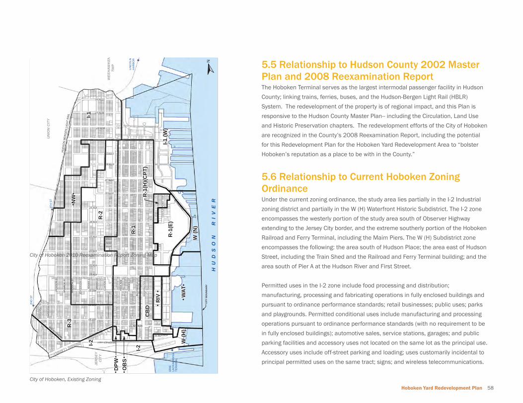
Hoboken Yard Redevelopment Plan 58
JER
SEY
CIT
Y
MA
RS
HA
LL S
T
HA
RR
ISO
N S
T
JAC
KS
ON
ST
MO
NR
OE
ST
MA
DIS
ON
ST
JEFF
ER
SO
N S
T
AD
AM
S S
T
GR
AN
D S
T
CLI
NTO
N S
T
WIL
LOW
AV
E
2ND ST
3RD ST
4TH ST
5TH ST
6TH ST
7TH ST
8THST
9TH ST
10TH ST
11TH ST
12TH ST
13TH ST
17THST
SINAT
RA DR
CA
STL
E P
OIN
T TE
R
GA
RD
EN
ST
BLO
OM
FIE
LD S
T
WA
SH
ING
TON
ST
HU
DS
ON
ST
RIV
ER
ST
SIN
ATR
A D
R
NEWARK ST
CIT
YB
OU
ND
AR
Y
LIN
CO
LNH
AR
BO
R
I-2
HU
DS
ON
BE
RG
EN
LIG
HT
RA
IL
UN
ION
CIT
Y
WEE
HAW
KEN
TWP
1ST ST
14TH ST
NEWARK ST
OBSERVER HWY
PATERSON AVE
16TH ST
15TH ST
HUDSON PL
PAR
K A
VE
2ND
ST
9TH
ST
ERIE
LA
CK
AWA
NN
ATE
RM
INA
L
R-1
R-2
I-1
R-3
I-2
I-1 (W
)
WAT
NW
R-1
(E)
CB
D
W (N
)
W (H
)
RIV
OB
S
R-1
(H)(C
PT)
DPW
H U
D S
O N
R I
V E
RN
City of Hoboken 2010 Reexamination Report Zoning Map
5.5 Relationship to Hudson County 2002 Master Plan and 2008 Reexamination ReportThe Hoboken Terminal serves as the largest intermodal passenger facility in Hudson
County; linking trains, ferries, buses, and the Hudson-Bergen Light Rail (HBLR)
System. The redevelopment of the property is of regional impact, and this Plan is
responsive to the Hudson County Master Plan-- including the Circulation, Land Use
and Historic Preservation chapters. The redevelopment efforts of the City of Hoboken
are recognized in the County’s 2008 Reexamination Report, including the potential
for this Redevelopment Plan for the Hoboken Yard Redevelopment Area to “bolster
Hoboken’s reputation as a place to be with in the County.”
5.6 Relationship to Current Hoboken Zoning Ordinance Under the current zoning ordinance, the study area lies partially in the I-2 Industrial
zoning district and partially in the W (H) Waterfront Historic Subdistrict. The I-2 zone
encompasses the westerly portion of the study area south of Observer Highway
extending to the Jersey City border, and the extreme southerly portion of the Hoboken
Railroad and Ferry Terminal, including the Maim Piers. The W (H) Subdistrict zone
encompasses the following: the area south of Hudson Place; the area east of Hudson
Street, including the Train Shed and the Railroad and Ferry Terminal building; and the
area south of Pier A at the Hudson River and First Street.
Permitted uses in the I-2 zone include food processing and distribution;
manufacturing, processing and fabricating operations in fully enclosed buildings and
pursuant to ordinance performance standards; retail businesses; public uses; parks
and playgrounds. Permitted conditional uses include manufacturing and processing
operations pursuant to ordinance performance standards (with no requirement to be
in fully enclosed buildings); automotive sales, service stations, garages; and public
parking facilities and accessory uses not located on the same lot as the principal use.
Accessory uses include off-street parking and loading; uses customarily incidental to
principal permitted uses on the same tract; signs; and wireless telecommunications.
City of Hoboken, Existing Zoning
59 Plan Relationships
Bulk standards in the I-2 zone for non-residential uses require a minimum lot area of
5,000 square feet, minimum lot width of 50 feet and minimum lot depth of 100 feet.
The required minimum front setback is 5 feet, the minimum rear setback is 15 feet,
and the minimum side yard setbacks are 5 feet for each side. The maximum building
height is 2 stories or 40 feet. Maximum lot coverage is 60% and the maximum FAR is
1.25.
Ordinance “performance standards” referenced above include the requirement for
buffer areas along street and lot lines for new industrial uses where the I-2 zone
abuts residential and special districts, and specifi cally indicates buffers are required
along Park Avenue, Willow Avenue and Observer Highway.
The W (H) Waterfront Historic Subdistrict within the W Waterfront District that was
created to promote comprehensive mixed-use development “at varying densities,
with visual and physical access to the Hudson River waterfront and linking other
commercial and residential areas of the city to the waterfront.” The W(H) district is
subject to review procedures of the Historic Commission.
Permitted uses in the W(H) zone include a range of public and water-oriented uses,
including educational, public recreation, and marina facilities and water-oriented
light commercial, recreational or passenger uses. Permitted accessory uses include
uses customarily incidental to a principal use. Permitted conditional uses include
transportation terminal facilities.
Bulk standards in the W(H) zone for all permitted and conditional uses require
a minimum lot area of 40,000 square feet, minimum lot width of 400 feet and
minimum lot depth of 400 feet. The maximum lot coverage is 30 percent for principal
buildings and 10 percent for accessory buildings. The maximum building height is 2
stories or 35 feet.
The study area is adjacent to several zoning districts which permit a range of uses.
The CBD District is a narrow band approximately three blocks wide that abuts the
northeastern portion of the property and is bounded by Observer Highway and
Hudson Place to the south, Garden Street and Bloomfi eld Street to the west, Fourth
Street to the north, and Terminal Plaza and River Street to the east. The extensive R-3
Residential and R-1 Residential zoning districts abut the I-2 zone to the northwest;
they are roughly bounded to the south by Newark Street and extend northward.
The lots to the north of the property along Observer Highway, located to the west of
Garden Street and south of Newark Street are also included in the I-2 zone.
The provisions of this Redevelopment Plan shall supersede all existing Zoning and
Development Regulations of the City of Hoboken that regulate development within
the Hoboken Yard Redevelopment Area in accordance with New Jersey’s Local
Redevelopment and Housing Law (N.J.S.A. 40A:12A-7.c).
5.7 Relationship to Jersey City/Hoboken Connectivity Study (Sub-regional Transportation Study conducted by North Jersey
Transportation Planning Authority and Hudson County)A sub-regional transportation study was completed in June 2011 for the
southwestern section of the Hoboken and Jersey City that includes the portion
of the redevelopment area. The study recommended street network connectivity
improvements between Jersey City and Hoboken for all vehicular, pedestrian and
bicycle modes of travel with future traffi c projections set to year 2025. Short term
recommendations enhance pedestrian and bicycle travel through the area. Medium
term improvements were recommended to the Observer Highway – Marine Boulevard
intersection as illustrated in the adjoining graphic. The Plan recommendations are
consistent with the recommendations of the Sub-regional Transportation Study.
Hoboken Yard Redevelopment Plan 60
5.8 Relationship to 2001 State Development and Redevelopment Plan and DRAFT New Jersey State Strategic Plan The Draft New Jersey State Strategic Plan was proposed by the Christie
administration in October of 2011 as an update to the 2001 State Development
and Redevelopment Plan. Although the Strategic Plan has not yet been adopted,
this Redevelopment Plan remains consistent with the proposed goals of targeted
economic growth, effective planning, preservation, and tactical alignment of
government resources. The Redevelopment Plan support’s the Strategic Plan’s vision
statement that “New Jersey will be the national leader in coordinated private and
public investment which supports sustainable communities that attract and provide
strong economic opportunities, preserve out State’s natural resources, and create
healthier communities to work, reside and recreate.” The proposed mixed use and
mixed modality are central to the Redevelopment Plan and move the City of Hoboken
in a direction consistent with the new Strategic Plan for New Jersey.
In addition, the Redevelopment Plan serves to implement the State Planning
Goals (N.J.S.A. 52:18A-196, et seq) of encouraging development, redevelopment
and economic growth in locations that are well situated with respect to present or
anticipated public services or facilities. The Redevelopment Plan for the Hoboken
Rail Yard is generally consistent with The State Development and Redevelopment
Plan Goals, particularly including;
Goal 1: Revitalize the State’s Cities and Towns by protecting, preserving, and
developing the valuable human and economic assets in cities, towns, and other
urban areas…
Goal 2: Conserve the state’s natural resources and systems as capital assets of
the public by promoting ecologically sound development and redevelopment in the
Metropolitan and Suburban Planning areas…
Goal 3: Promote socially and ecologically benefi cial economic growth, development
and renewal and improve both the quality of life and the standard of living of New
Jersey residents…
Goal 7: Preserve and Enhance Areas with Historic, Cultural, Scenic, Open Space and
Recreational Value by collaborative planning, design, investment and management
techniques.

61 Implementation

Hoboken Yard Redevelopment Plan 62
6 Implementation
63 Implementation
6.1 Site Plan and Subdivision ReviewAny subdivision of lots and parcels of land within the Redevelopment Area shall be in
accordance with the requirements of this Plan and Chapter 44. Land Use Procedures
of the City of Hoboken Ordinance.
6.2 New ConstructionConstruction of new structures and other improvements will take place as proposed
in Chapter 5 of this Redevelopment Plan. The designated redeveloper(s) shall
adhere to the parameters for development presented in Chapters 3 and 5 of this
Redevelopment Plan and refi ne the design concepts presented therein in developing
a unique and high-quality project proposal. Once a redeveloper is selected by the
City, the redeveloper will be required to enter into a Redevelopment Agreement with
the City that stipulates, among other things, the precise nature and extent of the
improvements to be made and their timing and phasing as permitted therein.
6.3 Acquisition As a signifi cant portion of the property within the redevelopment area is currently
owned or operated by NJ Transit, involuntary acquisition of properties located within
the redevelopment area is not contemplated by the City of Hoboken at this time. If
properties are conveyed to a private entity, then the City of Hoboken may consider
involuntary acquisition subject to an amendment of this Redevelopment Plan.
6.4 Other ActionsIn addition to the new construction and acquisition described above, several other
actions may be taken by the governing body to further the goals of the Plan. These
actions may include, but shall not be limited to: (1) provisions for public infrastructure
necessary to service new development (subject to the authority of NJ Transit, as
applicable) ; (2) environmental remediation; (3) vacation of public utility easements
and other easements and rights-of-way as may be necessary for redevelopment.
These costs for these actions shall be borne by the designated redeveloper(s).
6.5 Role of City The City of Hoboken, through the City Council acting as the Redevelopment Entity will
be solely responsible for the implementation of this Redevelopment Plan as set forth
below.
6.6 Redeveloper Selection In order to assure that the vision of the this Redevelopment Plan will be successfully
implemented in an effective, comprehensive and timely way, and in order to
promptly achieve the public purpose goals of the Plan, the City Council, acting as
the Redevelopment Entity, will select the redeveloper(s) in all areas governed by
this Redevelopment Plan. This Redevelopment Plan does not prohibit any owner or
contract-purchaser of property situated within the Redevelopment Area from seeking
designation by the City Council, in accordance with this chapter, as a redeveloper of
said property.
All designated redeveloper(s) will be required to execute a Redevelopment Agreement
satisfactory to and authorized by the City Council.
The procedural standards described here will guide redeveloper selection. The City
Council, acting as the Redevelopment Entity may, at any time, proactively solicit
potential redevelopers by utilizing appropriate methods of advertisement and other
forms of communication, or may, in its discretion entertain unsolicited proposal(s)
from a prospective redeveloper(s) for redevelopment of one or more redevelopment
parcels.
A prospective redeveloper will be required to submit materials to the City Council that
specify their qualifi cations, fi nancial resources, experience and design approach to
the proposed redevelopment project. The selection process will likely include the
submission of some or all of the following materials (additional submission materials
may be requested by the City Council as deemed appropriate to the particular project
sites.):
• Conceptual plans and elevations suffi cient in scope to demonstrate that
the design approach, architectural concepts, number and type of dwelling
units, retail and or commercial uses, parking, traffi c circulation, landscaping,
recreation space and other elements are consistent with the objectives and
standards of this Redevelopment Plan.
Hoboken Yard Redevelopment Plan 64
• Anticipated construction schedule, including estimated pre-construction time
period to secure permits and approvals.
• Documentation evidencing the fi nancial responsibility and capability of the
proposed redeveloper with respect to carrying out the proposed redevelopment
including but not limited to: type of company or partnership, disclosure of
ownership interest, list of comparable projects successfully completed, list of
references with name, address and phone information, list of any general or
limited partners, and fi nancial profi le of the redeveloper entity and its parent, if
applicable.
• Any prospective redeveloper seeking designation by the City Council as a
redeveloper of any property which is included in this Redevelopment Plan and
which is owned by NJ Transit must have entered into, and provided the City
Council with a complete copy of, a binding acquisition agreement between the
prospective redeveloper and NJ Transit for the subject property, which acquisition
agreement shall govern the coordination and implementation of site preparation,
relocation, demolition and construction on the subject property in accordance
with this Redevelopment Plan. If at the time of application, the subject property
is not owned by NJ Transit, but is the site of NJ Transit facilities or operations,
then the prospective redeveloper must have entered into, and provided the City
Council with a complete copy of, a binding agreement between the prospective
redeveloper and NJ Transit governing the coordination and implementation of
site preparation, relocation, demolition and construction on the subject property
in accordance with this Redevelopment Plan.
The following provisions regarding redevelopment are hereby included in connection
with the implementation of this Redevelopment Plan and the selection of a
redeveloper(s) for any property or properties included in the Redevelopment Plan
and shall apply notwithstanding the provisions of any zoning or building ordinance or
other regulations to the contrary:
• 1. The redeveloper will be obligated to carry out the specifi ed improvements
in accordance with the Redevelopment Plan, including construction of the
performing art center, the accelerator space and open space and recreation
amenities included in the Plan.
• 2. The redeveloper, its successor or assigns shall develop the property in
accordance with the uses and building requirements specifi ed in the
Redevelopment Plan.
• Until the required improvements are completed and a Certifi cate of Completion
is issued by the Redevelopment Entity, the redeveloper covenants provided for in
N.J.S.A. 40A:12A-9 and imposed in any redeveloper agreement, lease, deed or
other instrument shall remain in full force and effect.
• The Redevelopment Agreement(s) shall include a provision that requires the
redeveloper to provide for all affordable housing that is generated by its project,
to the extent required by law or the Plan.
• The Redevelopment Agreement(s) shall contain provisions to assure the timely
construction of the redevelopment project, the qualifi cations, fi nancial capability
and fi nancial guarantees of the redeveloper(s) and any other provisions to assure
the successful completion of the project.
• The designated redeveloper(s) shall be responsible for any installation or
upgrade of infrastructure related to their project whether on-site or off-site.
Infrastructure items include, but are not limited to parks, recreational and open
space, gas, electric, water, sanitary and storm sewers, telecommunications,
streets, curbs, sidewalks, street lighting and street trees or other improvements.
The extent of the designated redeveloper’s responsibility will be outlined in the
redeveloper’s agreements with the City. All utilities shall be placed underground.
• All infrastructure improvements shall comply with applicable local, state and
federal law and regulations.
• In addition to the provisions set forth herein, the Redevelopment Agreement may
provide that the redeveloper(s) will agree to provide amenities, benefi ts, fees and
payments in addition to those authorized under the Municipal Land Use Law.
6.7 Approvals Process This Redevelopment Plan changes the process by which approvals for the
development of land are typically granted. For a typical development application, a
property owner submits plans and an application to the Planning Board or Zoning
Board of Adjustment, and the board schedules a hearing on the application. However,
in order to comply with this Redevelopment Plan and to streamline the review
process, the following procedure will be followed:
City Council Review The City Council acting as the Redevelopment Entity shall review all proposed
65 Implementation
redevelopment projects within the redevelopment area to ensure that such project(s)
is consistent with the Redevelopment Plan and relevant redeveloper agreement(s).
Such review shall occur prior to the submission of the redevelopment project(s) to the
Planning Board. As part of its review, the City Council may require the redeveloper(s)
to submit proposed site plan applications to the City Council or to a subcommittee
organized by the City Council prior to the submission of such applications to the
Planning Board. Such Committee may include members of the City Council and any
other members and/or professionals as determined necessary and appropriate by
the City Council. Such Committee shall make its recom¬mendations to the Mayor and
Council.
In undertaking its review, the City Council shall determine whether the proposal is
consistent with this Redevelopment Plan and relevant redeveloper agreement(s). In
addition, the review may address the site and building design elements of the project
to ensure that the project adequately addresses the goals and objectives of this Plan.
Planning Board Review Process All development applications shall be submitted to the City of Hoboken Planning
Board through the normal site plan and subdivision procedures as outlined in N.J.S.A.
40:550-1 et seq. The Planning Board shall deem any application for redevelopment
for any property subject to this Redevelopment Plan incomplete if the applicant has
not been designated by the City Council as a redeveloper(s) and the project plan
has not been reviewed and approved by the City Council. Additionally, the Planning
Board shall deem any application for redevelopment for any property subject to this
Redevelopment Plan incomplete if the applicant has not received approval from
the City Council or any committee that it may designate for such purpose, stating
that the application is consistent with the Redevelopment Plan and Redevelopment
Agreement.
Variances Not to be Considered Neither the Planning Board nor the Board of Adjustment shall grant any deviations
from the terms and requirements of this Redevelopment Plan, including the granting
of any “c” or “d” variances. Any proposed changes to the Redevelopment Plan shall
be in the form of an amendment to the Redevelopment Plan adopted by the City
Council in accordance with the procedures set forth in the Local Redevelopment and
Housing Law, N.J.5.A. 40A:12A-1 et seq.
Easements No building shall be constructed over a public easement in the Redevelopment Area
without prior written approval of the City of Hoboken.
Site Plan and Subdivision Review Site plans should be submitted to the City Council (as redevelopment agency) for
approval prior to review and approval by the Planning Board. Prior to commencement
of construction, site plans for the construction and/or rehabilitation of improvements
within the Redevelopment Area, prepared in accordance with the requirements of
the Municipal Land Use Law (N.J.S.A. 40:55D-1 et seq.), shall be submitted by the
applicants for review and approval by the Hoboken Planning Board. Any subdivision of
lots and parcels of land within the Redevelopment Area shall be in accordance with
the requirements of this Redevelopment Plan and the subdivision ordinance of the
City of Hoboken, except that where this Redevelopment Plan contains provisions that
differ from those in the subdivision ordinance, this plan shall prevail.
Approvals by Other Agencies The redeveloper shall be required to provide the City with copies of all permit
applications made to federal, state and county agencies upon fi ling such applications,
as will be required by the redeveloper’s agreement to be executed between the
redeveloper and the City.
Certifi cate of Completion and Compliance Upon the inspection, verifi cation and approval by the City Council that the
redevelopment of a parcel subject to a Redevelopment Agreement has been
completed, a Certifi cate of Completion and Compliance will be issued to the
redeveloper and such parcel will be deemed no longer in need of redevelopment.
6.8 Severability The provisions of this Redevelopment Plan are subject to approval by Ordinance. If a
Court of competent jurisdiction fi nds any word, phrase, clause, section, or provision of
this Redevelopment Plan to be invalid, illegal, or unconstitutional, the word, phrase,
clause, section, or provision shall be deemed severable, and the remainder of the
Redevelopment Plan and implementing Ordinance shall remain in full force and
effect.

Hoboken Yard Redevelopment Plan 66
6.9 Adverse Infl uences No use or reuse shall be permitted which, when conducted under proper and
adequate conditions and safeguards, will produce corrosive, toxic or noxious fumes,
glare, electromagnetic disturbance, radiation, smoke, cinders, odors, dust or waste,
undue noise or vibration, or other objectionable features so as to be detrimental to
the public health, safety or general welfare.
6.10 Non-Discrimination Provisions No covenant, lease, conveyance or other instrument shall be affected or executed
by the City Council or by a developer or any of his successors or assignees, whereby
land within the Redevelopment Area is restricted by the City Council, or the developer,
upon the basis of race, creed, color, national origin, ancestry, marital status or sex in
the sale, lease, use or occupancy thereof. Appropriate covenants, running with the
land forever, will prohibit such restrictions and shall be included in the disposition
instruments. There shall be no restrictions of occupancy or use of any part of the
Redevelopment Area on the basis of race, creed, color, national origin, ancestry,
marital status or sex .
6.11 Escrows The redeveloper shall be responsible to post suffi cient escrows to cover any
and all costs of the professional consultants retained by the City to review the
proposed redevelopment project and advise the City on any and all aspects of the
redevelopment process and as otherwise set forth in a Redevelopment Agreement.
6.12 Infrastructure The redeveloper, at the redeveloper’s cost and expense, shall provide all necessary
engineering studies for, and construct or install all on- and off-site municipal
infrastructure improvements and capacity enhancements or upgrades required in
connection with the provision of water, sanitary sewer, and stormwater sewer service
to the project, in addition to all required tie-in or connection fees. The redeveloper
shall also be responsible for providing, at the redeveloper’s cost and expense, all
sidewalks, curbs, streetscape improvements (street trees and other landscaping),
street lighting, and on- and off¬site traffi c controls and road improvements for the
project or required as a result of the impacts of the project. The Redevelopment
Agreement between the City and the redeveloper will contain the terms, conditions,
specifi cations, and a description of required performance guarantees (such as
performance bonds or other acceptable performance security) pertaining to
redeveloper’s obligation to provide the infrastructure and improvements required for
the project.
6.13 Duration of the Plan The provisions of this Plan specifying the redevelopment of the Redevelopment Area
and the requirements and restrictions with respect thereto shall be in effect for a
period of 40 years from the date of approval of this plan by the City Council.
Procedure for Amending the Approved Plan
This Redevelopment Plan may be amended from time to time upon compliance with
the requirements of state law. A non-refundable application fee of $5,000 shall be
paid by the party requesting such amendment, unless the request is issued from an
agency of the City. The City of Hoboken Council, at its sole discretion, may require
the party requesting the amendments to prepare a study of the impact of such
amendments, which study must be prepared by a professional planner licensed in
the State of New Jersey.
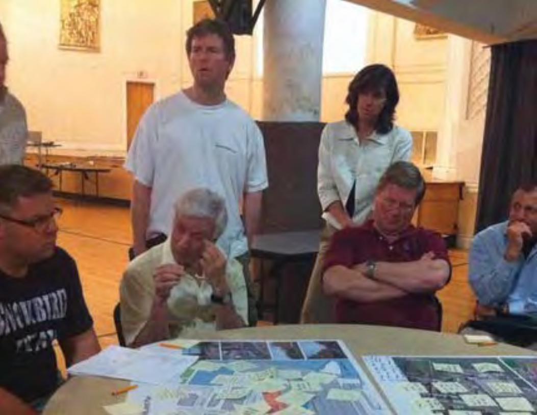
67 Appendix A: Planning Process

Hoboken Yard Redevelopment Plan 68
Appendix A: Planning Process
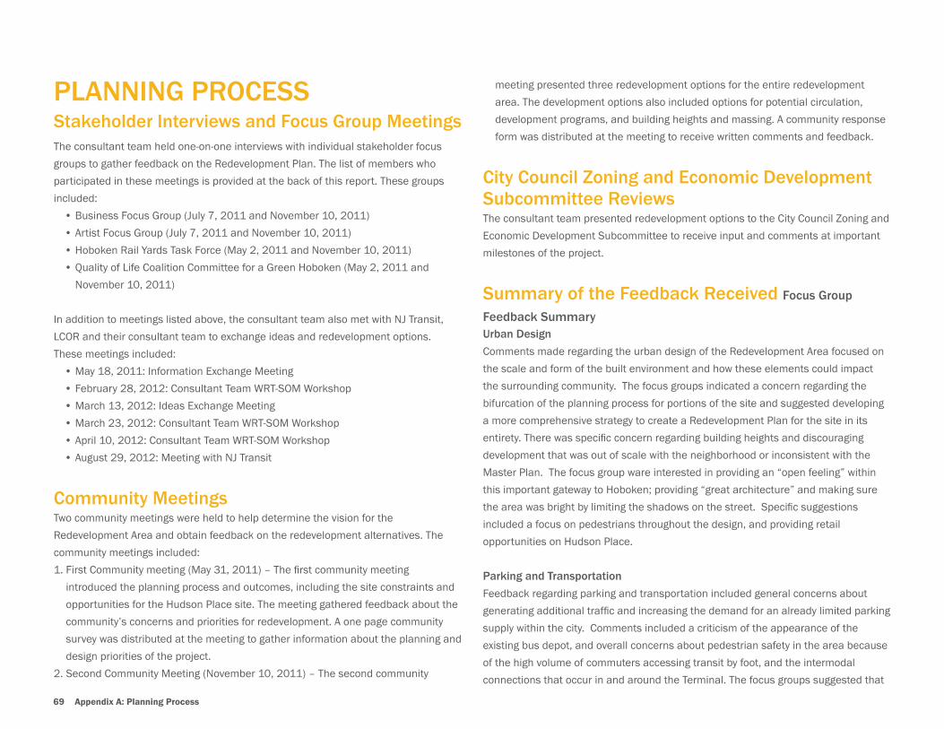
69 Appendix A: Planning Process
PLANNING PROCESSStakeholder Interviews and Focus Group MeetingsThe consultant team held one-on-one interviews with individual stakeholder focus
groups to gather feedback on the Redevelopment Plan. The list of members who
participated in these meetings is provided at the back of this report. These groups
included:
• Business Focus Group (July 7, 2011 and November 10, 2011)
• Artist Focus Group (July 7, 2011 and November 10, 2011)
• Hoboken Rail Yards Task Force (May 2, 2011 and November 10, 2011)
• Quality of Life Coalition Committee for a Green Hoboken (May 2, 2011 and
November 10, 2011)
In addition to meetings listed above, the consultant team also met with NJ Transit,
LCOR and their consultant team to exchange ideas and redevelopment options.
These meetings included:
• May 18, 2011: Information Exchange Meeting
• February 28, 2012: Consultant Team WRT-SOM Workshop
• March 13, 2012: Ideas Exchange Meeting
• March 23, 2012: Consultant Team WRT-SOM Workshop
• April 10, 2012: Consultant Team WRT-SOM Workshop
• August 29, 2012: Meeting with NJ Transit
Community MeetingsTwo community meetings were held to help determine the vision for the
Redevelopment Area and obtain feedback on the redevelopment alternatives. The
community meetings included:
1. First Community meeting (May 31, 2011) – The fi rst community meeting
introduced the planning process and outcomes, including the site constraints and
opportunities for the Hudson Place site. The meeting gathered feedback about the
community’s concerns and priorities for redevelopment. A one page community
survey was distributed at the meeting to gather information about the planning and
design priorities of the project.
2. Second Community Meeting (November 10, 2011) – The second community
meeting presented three redevelopment options for the entire redevelopment
area. The development options also included options for potential circulation,
development programs, and building heights and massing. A community response
form was distributed at the meeting to receive written comments and feedback.
City Council Zoning and Economic Development Subcommittee ReviewsThe consultant team presented redevelopment options to the City Council Zoning and
Economic Development Subcommittee to receive input and comments at important
milestones of the project.
Summary of the Feedback Received Focus Group
Feedback SummaryUrban Design
Comments made regarding the urban design of the Redevelopment Area focused on
the scale and form of the built environment and how these elements could impact
the surrounding community. The focus groups indicated a concern regarding the
bifurcation of the planning process for portions of the site and suggested developing
a more comprehensive strategy to create a Redevelopment Plan for the site in its
entirety. There was specifi c concern regarding building heights and discouraging
development that was out of scale with the neighborhood or inconsistent with the
Master Plan. The focus group ware interested in providing an “open feeling” within
this important gateway to Hoboken; providing “great architecture” and making sure
the area was bright by limiting the shadows on the street. Specifi c suggestions
included a focus on pedestrians throughout the design, and providing retail
opportunities on Hudson Place.
Parking and Transportation
Feedback regarding parking and transportation included general concerns about
generating additional traffi c and increasing the demand for an already limited parking
supply within the city. Comments included a criticism of the appearance of the
existing bus depot, and overall concerns about pedestrian safety in the area because
of the high volume of commuters accessing transit by foot, and the intermodal
connections that occur in and around the Terminal. The focus groups suggested that
Hoboken Yard Redevelopment Plan 70
the Redevelopment Plan for the area work toward a more effective integration of
pedestrian and bicycle modes.
Infrastructure and Sustainable Design
The focus groups expressed concerns regarding the capacity of the city’s existing
infrastructure to accommodate additional development within the area, and general
suggestions were made that the Redevelopment Plan should maintain a sustainable
design focus.
Results of the Community Surveys
The city received feedback from 59 individuals through the community survey
process regarding the Hoboken Terminal and Rail Yard and its redevelopment
potential. The majority of respondents (78%) indicated that they judged redeveloping
the Hoboken Terminal and Rail Yard property as very important to the future of
Hoboken. The survey respondents were asked how the City should be involved in
the redevelopment effort and 52.8% indicated that the City should enter into a joint
agreement with NJ Transit to ensure that the development achieved the community
goals in accordance with the Redevelopment Plan.
The responses were divided among community goals for the area, but the highest
responses included the creation of a new employment center for the area, an
expanded tax base for the city, a new gateway, transportation improvements,
and a sustainable, world class design. Concerns from respondents regarding
a redevelopment plan for the area were also evenly divided, and included the
potential increase in traffi c, demand for parking, pedestrian safety, building heights,
infrastructure capacity, and lack of open space and pedestrian amenities. The
results of the surveys helped to inform the design principles used to develop the
Redevelopment Plan.
Summary of Response to AlternativesAlternative development and circulation scenarios for the Hoboken Yard
Redevelopment Area were presented to the community at a public meeting in
November of 2011. The discussion of these development options prompted several
suggestions and elicited a range of concerns from community members regarding
land uses, parking and transportation, building heights and massing, and Public
Space and Pedestrian Plazas within the Redevelopment Area. These concerns
include:
Land Use Concerns• Maximize commercial uses
• Include high end and service oriented retail
• Include day care
• Concerns about the compatibility of residential uses adjacent to train tracks
• Public space is needed for theater ensemble rehearsals
• Include arts display area and a large public theatre or meeting space
• Concerns regarding the access to transit and distance of offi ces at the west end
of the site
• Concerns about sustaining retail and offi ce tenants into the future
Parking and Transportation Concerns• Connection problems if the bus terminal were to be moved away from the train
station
• Aesthetics and service would be improved if bus terminal were to be enclosed.
• A traffi c and parking assessment was suggested for specifi c buildings
• Warrington plaza should remain a pedestrian and cyclist friendly area
• Suggest review of roundabout for the junction of Marin and Observer Boulevards
• Trolley service suggested to reduce the number of cars on the streets in the area
• Concerns about taxi stand in front of 77 River Street Building
Building heights and Massing Concerns• Avoid a “canyon effect” along Observer Blvd.
• Need variation and smart use of set-backs
• Suggested height between 4 to 16 stories
• Phase I site building height should not exceed height of other buildings at
Hudson Place
• Focal point, tall building facing Washington and Bloomfi eld Streets (14-16
stories)
Public Space and Pedestrian Plazas Concerns• Increase park space on a per-resident basis
• Create large open space as a “magnet” lined with retail, restaurants and cafes
• Put a major park further west
• Provide European style squares to encourage connections and retail use
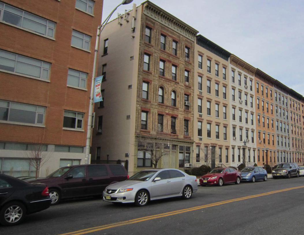
71 Appendix B: Redevelopment Alternatives

Hoboken Yard Redevelopment Plan 72
Appendix B: Design Alternatives

73 Appendix B: Redevelopment Alternatives
REDEVELOPMENT ALTERNATIVESThree redevelopment alternatives were developed for the Redevelopment Area,
including the Warrington Plaza and Hudson Place sites, for the purpose of
gaining feedback from the public and stakeholders to derive a fi nal plan from the
preferred features and elements. These redevelopment alternatives represented a
development framework based on the planning and design principles developed as
a result of existing conditions analysis, stakeholder input, and community feedback.
The proposed alternatives were based on the development program assumptions,
and take into consideration existing plans for transportation facility and structural
improvements. Each alternative provided the fl exibility to incorporate future transit-
related improvements to be undertaken at the discretion of NJ Transit.
These alternatives illustrate options for development programs; including different
building height and bulk massing, circulation and open space.
Existing Hudson Place Section
Alternative A: Hudson Place Alternative B: Hudson Place Alternative C: Hudson Place

Hoboken Yard Redevelopment Plan 74
Common Elements of Redevelopment Alternatives
Conversion of Observer Highway into Observer BoulevardReconfi guration of the existing Observer Highway is envisioned as part of the
redevelopment effort to mitigate traffi c and improve pedestrian and vehicular
circulation. All alternatives show conversion of Observer Highway into a Boulevard
and complete street accommodating pedestrians, bicycles and vehicular traffi c.
Parking and Service AccessAll alternatives show structured parking behind buildings and above ground fl oor
retail. The alternatives also show shared and inter-connected parking garages across
the development sites to maximize effi ciencies and sharing between various uses.
Minimal parking ratios are used to reduce parking need. Service and parking access
to buildings are shown via service / access roads behind the buildings.
Proposed Observer Boulevard Typical Section

75 Appendix B: Redevelopment Alternatives
Alternative A – Mixed Use Node
Development ProgramAlternative A proposed offi ce (with ground fl oor retail) uses closer to Hudson Place
and a landmark offi ce building at the site near Washington Street and the Records
Building. This alternative also provided offi ce uses at the gateway location at
Observer Boulevard and Marin Boulevard.
A residential mixed-use node between Garden Street and Bloomfi eld Street closer to
the Terminal was proposed as an activity center in this alternative. This activity node
was anchored by a park lined with retail such as restaurants and cafes. The node
could have also include a large public theatre or performing arts center to activate
the open space. Residential buildings were proposed west of the mixed-use node.
Building Height and MassingAlternative A showed variation in building heights and massing to avoid a canyon
effect at Hudson Place and along Observer Boulevard. Alternative A included taller
buildings between 8 to 14 stories perpendicular to Observer Boulevard to avoid
shadows on Observer Boulevard during winter months.
Alternative A showed higher buildings, with a maximum of 14 – 16 stories at the ends
of the redevelopment site; Hudson Place, and Marin Blvd/Observer Blvd.
Hudson Place BuildingAlternative A includee a 16- story mid-rise offi ce building with about 460,000 gross
square footage at Hudson Place.
Alternative A: Hudson Place BuildingAlternative A: Observer Boulevard

Hoboken Yard Redevelopment Plan 76
Alternative A Illustrative Site Plan
Alternative A Land Uses
Alternative A Building Heights

77 Appendix B: Redevelopment Alternatives
Alternative B – Offi ce at Strategic Locations
Development ProgramThis alternative included offi ce uses at the gateway location at Observer Boulevard
and Marin Boulevard, and a landmark offi ce building at Hudson Place near the
Terminal. Residential uses were proposed on all development sites along Observer
Boulevard
Alternative B also proposed a linear park beginning at Washington Avenue and
extending west of the Redevelopment Area along Observer Boulevard. This open
space would be anchored by ground fl oor retail, including restaurants and cafes.
Building Height and MassingAlternative B showed variation in building heights similar to Alternative A; including
greater building heights at strategic locations such as at Hudson Place, in the center
of the Redevelopment Area, and at the intersection of Marin Boulevard and Observer
Boulevard.
Alternative B: Hudson Place BuildingAlternative A: Observer Boulevard
Hudson Place BuildingAlternative B includes a 26- story high rise offi ce building of about 550,000 gross
square feet at Hudson Place.

Hoboken Yard Redevelopment Plan 78
Alternative B Illustrative Site Plan
Alternative B Land Uses
Alternative B Building Heights
79 Appendix B: Redevelopment Alternatives
Alternative B: Hudson Place BuildingAlternative A: Observer Boulevard
Alternative C – Open Space Nodes
Development ProgramAlternative C included an open space system with smaller piazza at each
development parcel. The alternative showed offi ce uses at Hudson Place and along
Observer Boulevard west of Park Avenue. Residential uses were shown closer to the
Terminal, between Washington Street and Park Avenue.
Building Height and MassingAlternative C showed taller offi ce buildings west of Park Avenue, and followed the
same principle of variation of building heights as Alternatives A and B.
Hudson Place BuildingAlternative C included a low-rise offi ce building varying in height from 8 stories to 14
stories with about 550,000 gross square feet of space at Hudson Place.
Hoboken Yard Redevelopment Plan 80
Alternative C Illustrative Site Plan
Alternative C Land Uses
Alternative C Building Heights

81 Appendix B: Redevelopment Alternatives
Revisions to Alternative A
Revisions to Alternative B
Revisions to Alternative C
Hoboken Yard Redevelopment Plan 82
Revisions to the AlternativesA number of revisions were made to the original alternatives based on the feedback
received from the City, stakeholders, focus groups, and public input from the second
community meeting on November 10th. Adjoining fi gures show revisions to the
alternatives. These revisions included:
Changes to the Southern Boundaries or Parcel DepthNJ Transit and its consultant team provided clarifi cation on the depth of the
redevelopment sites along the Observer Boulevard available for redevelopment
excluding the rail tracks. In deference to NJ Transit’s role and expertise regarding
transportation matters, the effective parcel depth available for redevelopment was
therefore reduced from220 feet to 150 feet.
Relocation of Offi ce Uses closer to the TerminalOffi ce uses shown along the west end of the development at Marin Boulevard) were
moved closer to the Terminal near Washington Avenue.
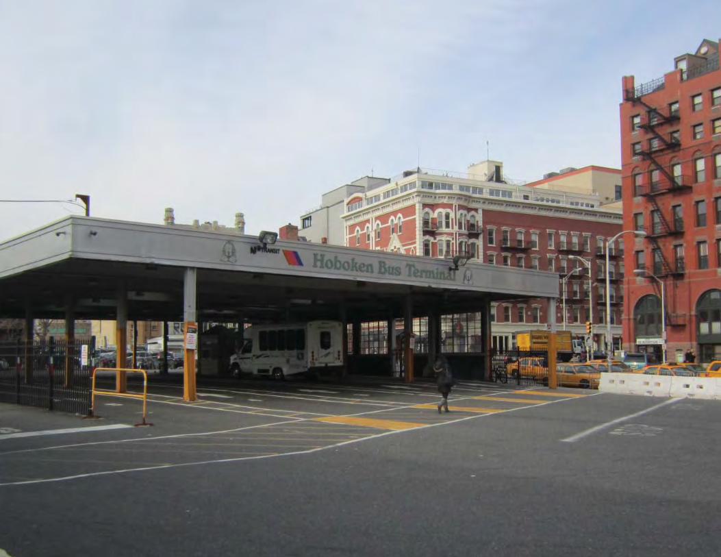
83 Appendix C: Circulation Alternatives

Hoboken Yard Redevelopment Plan 84
Appendix C: Circulation Alternatives

85 Appendix C: Circulation Alternatives
CIRCULATION ALTERNATIVES:
Warrington Plaza / Hudson Place Circulation OptionsSeveral circulation-related options were developed independent of the three
redevelopment alternatives mentioned above to evaluate and improve existing
pedestrian conditions near the Terminal. These options included opportunities to
reconfi gure the existing location of taxi cab stands, jitney bus stops, bicycle lanes,
support facilities, vehicular drop off areas, pedestrian sidewalks, and crossings to
improve pedestrian and vehicular conditions near the Terminal. These circulation
options are not dependent on the location of NJ Transit’s new Bus Terminal, and
are all subject to determinations to be made by NJ Transit, and are not required
components of this Redevelopment Plan.
The following circulation options were set forth to provide guidance to NJ Transit, if
and when it determines to proceed with any of these improvements:
Option A• Maintained vehicular traffi c on Hudson Place with a turnaround at Warrington
Plaza to accommodate a commuter drop off area.
• Maintained the existing location of the taxi stand, and provided an alternative
location for additional taxi parking north of Newark Street between River Street
and Sinatra Drive.
• Provided two locations for Jitney Bus drop off and pick up areas; one for north
bound buses at Newark Street between Hudson Street and Sinatra Drive,
and one for south bound buses at Hudson Street between Hudson Place and
Observer Boulevard.
• Maintained the location of the Bus Terminal as proposed by NJ Transit in
December 2010.
• Provided an additional drop off area on the south side of Hudson Place between
Hudson Street and River Street.
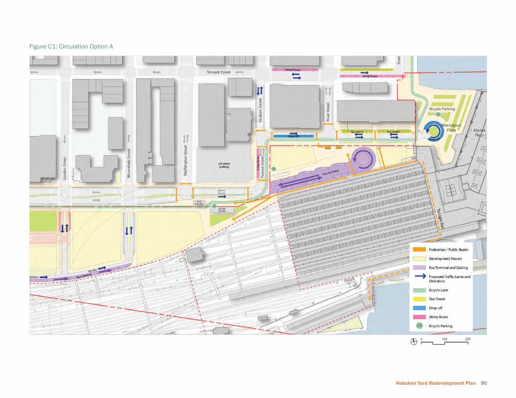
Hoboken Yard Redevelopment Plan 86
Figure C1: Circulation Option A
200’100’0

87 Appendix C: Circulation Alternatives
Circulation Option B Plan
200’100’0
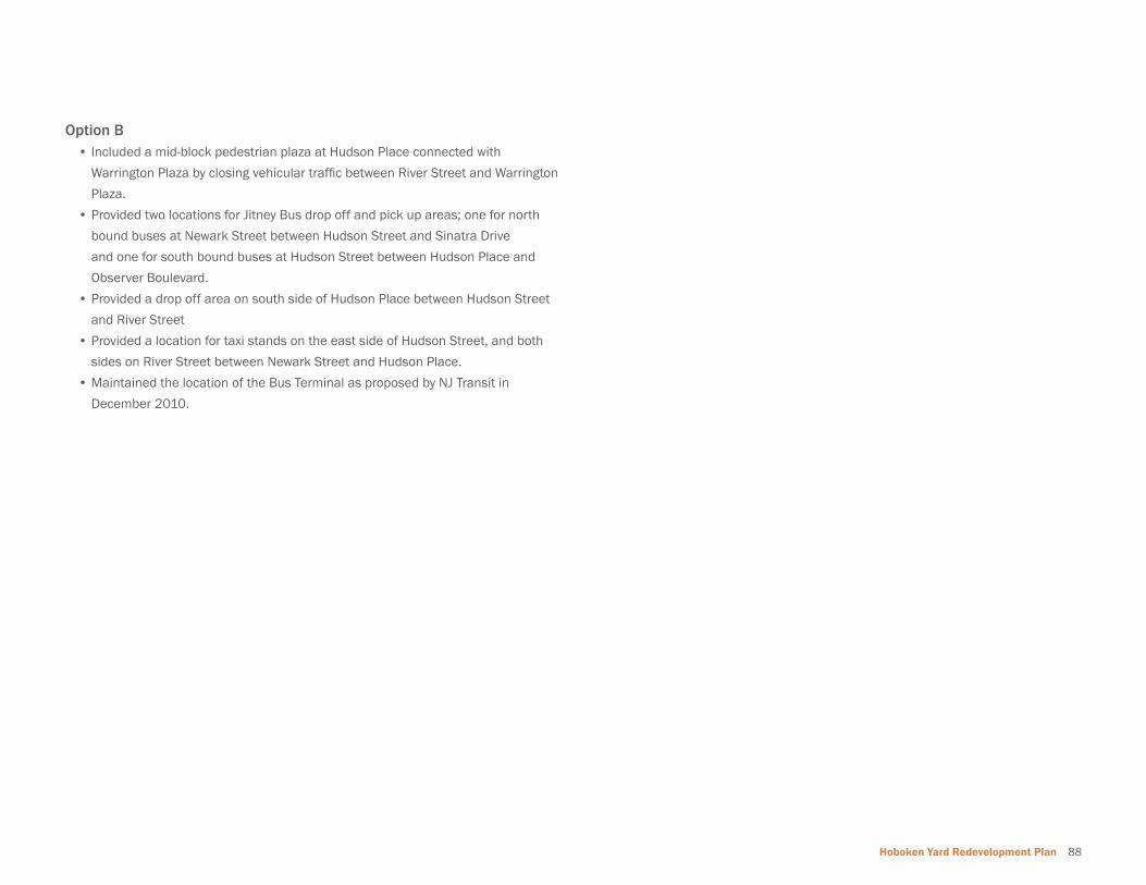
Hoboken Yard Redevelopment Plan 88
Option B• Included a mid-block pedestrian plaza at Hudson Place connected with
Warrington Plaza by closing vehicular traffi c between River Street and Warrington
Plaza.
• Provided two locations for Jitney Bus drop off and pick up areas; one for north
bound buses at Newark Street between Hudson Street and Sinatra Drive
and one for south bound buses at Hudson Street between Hudson Place and
Observer Boulevard.
• Provided a drop off area on south side of Hudson Place between Hudson Street
and River Street
• Provided a location for taxi stands on the east side of Hudson Street, and both
sides on River Street between Newark Street and Hudson Place.
• Maintained the location of the Bus Terminal as proposed by NJ Transit in
December 2010.

89 Appendix C: Circulation Alternatives
Circulation Option C Plan
200’100’0
Hoboken Yard Redevelopment Plan 90
Option C• This Option was a variation of Option A, with an alternative location for a Bus
Terminal between Garden Street and Washington Street behind the proposed
development.
• Relocation of the taxi stand from Hudson Place to River Street between Newark
Street and Hudson Place and between Hudson Street and River Street.
• Provided two locations for Jitney Bus drop off and pick up areas; one for north
bound buses at Newark Street between Hudson Street and Sinatra Drive,
and one for south bound buses at Hudson Street between Hudson Place and
Observer Boulevard.
• This Option reduced the cartway width of Hudson Place for vehicular traffi c to
provide increased sidewalk width and increase safety by reducing vehicular
speed around the Terminal.
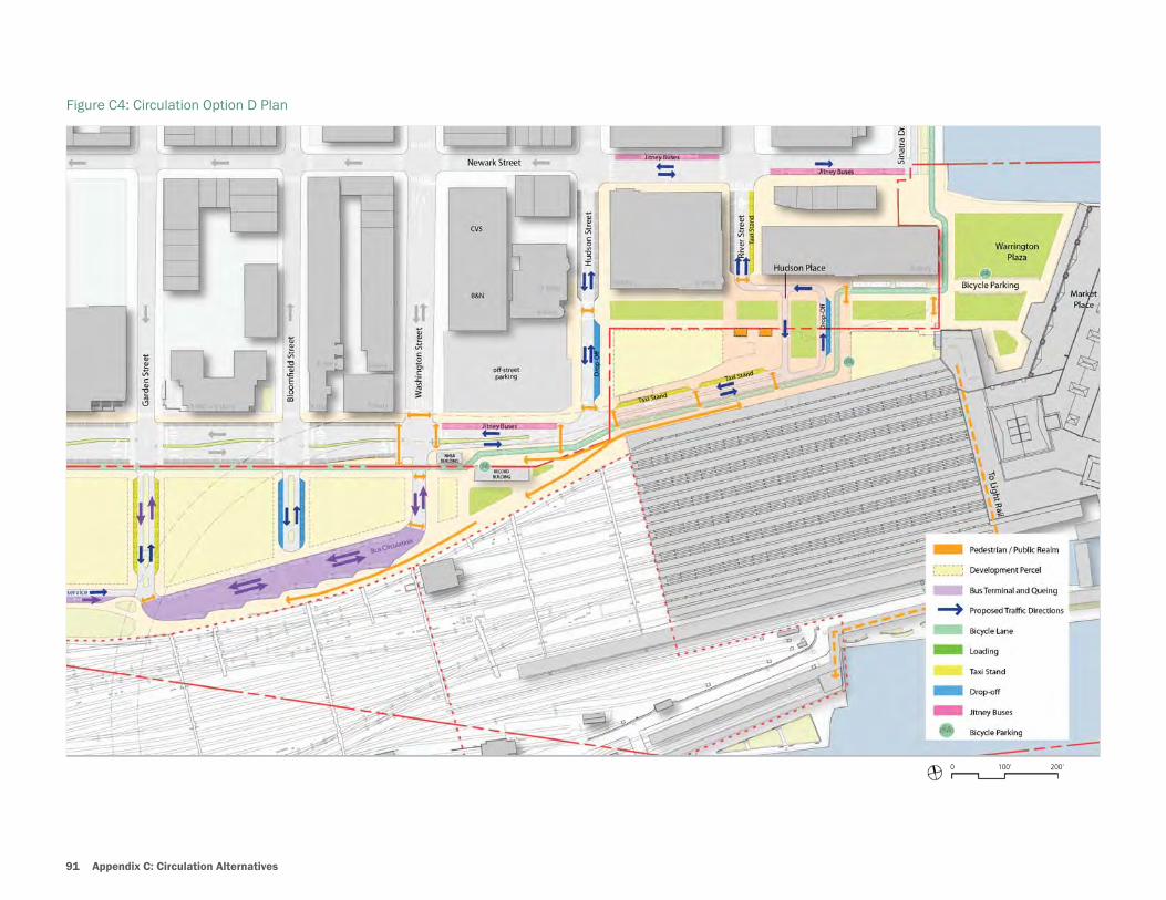
91 Appendix C: Circulation Alternatives
Figure C4: Circulation Option D Plan
200’100’0

Hoboken Yard Redevelopment Plan 92
Option D• Converted Hudson Place into a pedestrian transit plaza.
• Provided an alternative location for a Bus Terminal between Garden Street and
Washington Street behind the proposed development.
• Incorporated two locations for Jitney Bus drop off and pick up areas; one for
north bound buses at Newark Street between Hudson Street and Sinatra Drive,
and one for south bound buses at Hudson Street between Hudson Place and
Observer Boulevard.
• Extended Observer Boulevard to the east to connect with River Street for
vehicular access and drop off area close to the Terminal.
Option D1 and Option D2• Two variations of the above Option D were developed (see next page).
• Option D1 accomodates changes to circulation option as provided in Option D
due to changes to parcel depth along Observer Highway.
• Option D2 shows locaiton of the Bus Terminal at Hudson Place while keeping the
pedestrial oriented design of the transit plaza.

93 Appendix C: Circulation Alternatives
Figure C4: Circulation Option D1 Plan
200’100’0
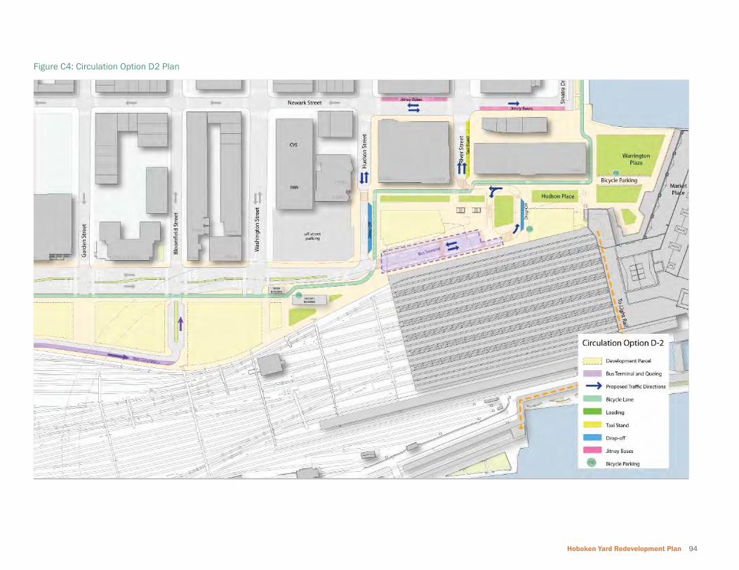
Hoboken Yard Redevelopment Plan 94
Figure C4: Circulation Option D2 Plan

Consultant Team
WRTPlanning, Urban Design, Architecture, Landscape Architecture
Nando Micale, FAIA, AICP, PPPrincipal
Yogesh Saoji, AIA, AICP, LEED AP BD+CSenior Associate / Project Manager
Ayako OkutaniUrban Designer / Planner
Brian TraylorPlanner
My LyArchitect
Robert B. Pauls, LLCReal Estate and Planning Consultants
Robert B. PaulsPresident
Barbara J. CohenSenior Associate
Marazity, Falcon and Healy, LLPRedevelopment and Environmental Law & Litigation
Joseph J. Maraziti, Jr., Esq.Partner
Christopher D. Miller, Esq.Senior Associate

Hoboken Yard Redevelopment Plan

Hoboken Yard Redevelopment Plan