Embed Size (px)
Citation preview

HMP Standford Hill Wind Energy Development
December 2010 TNEI Services Ltd Copyright Partnerships for Renewables Development Co. Ltd 2010 ©
Appendix 10.3 Eastchurch Airfield

HMP Standford Hill
Wind Energy Development
Chapter 10 - Cultural Heritage APPENDIX 10.3 : Eastchurch Airfield
30th. September 2010
Oxford Archaeological Associates Limited
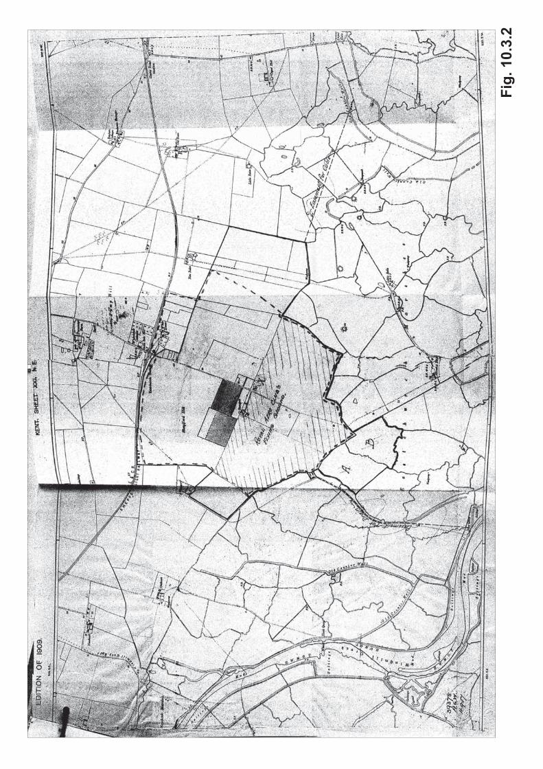
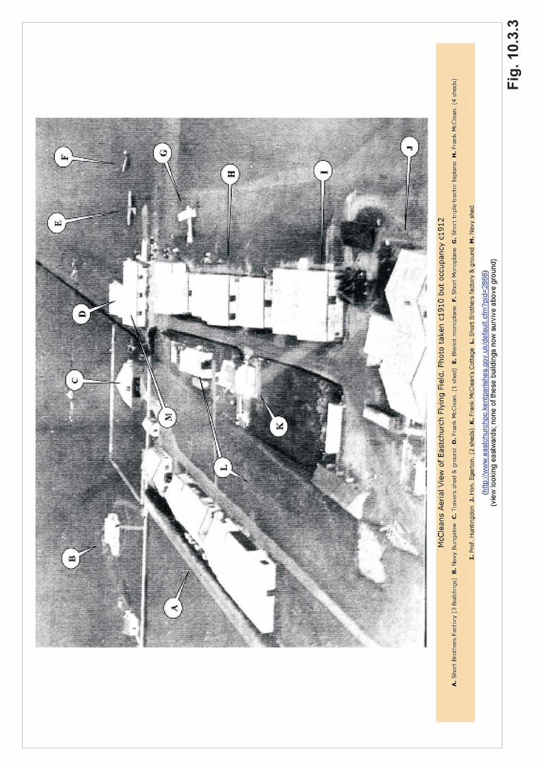
Eastchurch Airfield The surviving structures of the former Eastchurch Airfield (which lay within what is now Prison Service land) are shown in plan on Fig. 10.3.1; Figs. 10.3.17 – 10.3.29 are photographs of the principal buildings. History Aviation at Eastchurch started with the pioneer experiments with fixed-wing flight by the Aero Club (later the Royal Aero Club) of London. Initially concerned with lighter-than-air flight (balloons, dirigibles and airships), members of the Aero Club soon wished to emulate the Wright Brothers after their first fixed-wing flight in the USA in 1903. The Isle of Sheppey was chosen as a location for this, both because it was known to the members of the club as a destination for their balloon flights from London, following the prevailing wind, and because it was largely flat and the landscape contained few obstacles such as trees and hedges (NA AIR/1/2400 1). However their initial site, near Leysdown, was found to be unsatisfactory because of the unevenness of the ground. The land south of Eastchurch that the Club came to next was discovered by Charles Rolls (already the part owner of Rolls-Royce, the car makers, but whose enthusiasms had now moved from motoring to flying) when making flights with a fixed-wing glider from Standford Hill. Stonepits Farm was purchased by Francis McClean in 1909 and leased to the Club for a nominal sum (Fig. 10.3.2). Charles Rolls himself made the first flight to the new airfield from Leysdown in November 1909. Other aircraft arrived more prosaically by road. By September 1910 there were 18 sheds for Royal Aero Club members, as well as the sheds used by Short Brothers to build aircraft – they held the British rights to the Wright Brothers designs (Figs. 10.3.3 – 4). In December 1910, Tommy Sopwith (later an aircraft manufacturer himself) flew from Eastchurch to Belgium, to win the de Forest Prize (and £4000) for the longest flight from Britain into Europe. In July 1911, Eastchurch was the site for the third Gordon-Bennett Aviation Cup, an international air race; the two previous races had been in Reims and New York. At this stage in its history, the airfield has been described as a “rather fashionable centre for the wealthier members of the flying fraternity” (Ashworth 1990, 88). Perhaps hyperbolically, the Clerk to Sheerness Rural District Council described it in 1913 (in connection with the installation of mains water supply to Eastchurch) as “now one of the greatest aviation stations in the country” (Sheerness Guardian, March 8, 1913). By this time, though, aviation had become more than just a diversion for rich enthusiasts. Fuelled by elements of the national press, by 1911 there was pressure in Britain to interest the armed forces in fixed-wing aviation, as part of a general move to ensure that the country was not left behind in the development of air power (Gollin 1989, 161). In November 1910, as part of this process, the Royal Aero Club offered the use of their Eastchurch airfield and aircraft, and free flying lessons for naval officers, to the Admiralty, which up to that point had been more interested in lighter-than-air flight. Under intense pressure from the media, the Admiralty accepted the offer, and were able to select four trainees from among 1 This is the principal source of the following account and is that quoted, without acknowledgement but verbatim, by Halpenny 1993.
200 volunteers (despite stringent conditions: volunteers had to join the Royal Aero Club at their own expense). There were some setbacks to the programme: for example, the trainer originally chosen to instruct the seamen vanished on a flight over the English Channel before he could start. Despite this, the first four trainees gained their RAeC aviator’s certificates in May 1911. The four proved strong advocates of the need for naval aviation expertise and, in October 1911, the Admiralty set up the Naval Flying School at Eastchurch. In February 1912 It leased 10 acres of land from Francis McLean to build permanent accommodation (six large sheds, 3 canvass hangars and, as plans show, living accommodation for officers and men). The sheds were enlarged in June 1913 (Figs. 10.3.5 – 6). Administratively, Eastchurch was absorbed into the Royal Flying Corps, on its formation in April 1912 becoming the headquarters of the Naval Wing, and then a major base for the Royal Naval Air Service on its creation in July 1914. It was the principal site for training and experimentation by naval aviation throughout this period. Planes were adapted to land on the sea, and to take off from ships. Aircraft from Eastchurch were at the forefront of all these developments. As it was realised that, in future warfare, aircraft would be used for combat, as well as reconnaissance, Eastchurch carried out early trials of bomb-dropping and air-to-air combat, with both airships and other fixed-wing aircraft. The airfield had been requisitioned for war service in 1914; this marks the end of its period as a civilian airfield. On the outbreak of WWI, most military aircraft went with the British Expeditionary Force to France, leaving Eastchurch with its training role. However, at the same time Winston Churchill, as Lord of the Admiralty, was successfully arguing strongly for the need for home defence squadrons to protect naval bases and other home-based targets, and for these aircraft to be provided by the Royal Naval Air Service. Eastchurch became the base for aircraft defending the Medway naval bases, as well as London and the Thames Estuary. Although Eastchurch aircraft took part in actions against, for example, the Zeppelin raids on London in 1916, no noteworthy successes were registered.
There was more physical expansion in 1916 (Ashworth 1990), when new hangars were built to the east, and in 1917 the Shorts Brothers works were taken over (aircraft building had transferred to Rochester). By the end of the war there were 50 acres of buildings including 29 hangars (Figs 10.3.7 – 9). A railway siding into the airfield was planned in 1916 (NA AIR 2/19) but was not actually constructed until just after the end of war 2.
In April 1918, the Royal Naval Air Service and the Royal Flying Corps merged to become the Royal Air Force, and Eastchurch lost its link with the navy. It retained its training role, however, and became the RAF’s Armament and Gunnery School, re-named the Air Armament School from 1937 (Figs 10.3.10 – 12). As war again threatened, it was prudent to move the base’s training functions to locations less vulnerable to attack from the continent and Eastchurch was placed on a care and maintenance footing from September 1939. The airfield came to life again in December 1939, when those members of the Polish air force who had managed to escape capture by the Germans were gathered together at Eastchurch and re-trained prior to being sent to active service units elsewhere (Brooks 1998, 93).
2 The siding appears on a map of the airfield in 1923 (RAF Museum Hendon MFC 78/24/404) but was not present on an aerial photograph taken c.1918 (Fig. 10.3.9).
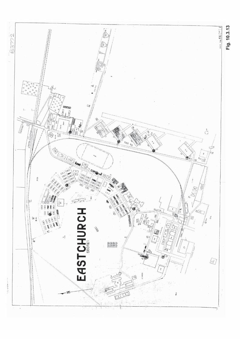
In May 1940, reconnaissance squadrons displaced by the advance of German forces in Europe were stationed at Eastchurch, followed after a few months by a squadron of light bombers, tasked with attacking the invasion build-up across the Channel. Finally two squadrons of Spitfires arrived at the height of the Battle of Britain, in early August (Brooks 1998, 93-4). The concentration of aircraft at Eastchurch naturally attracted the attention of the Luftwaffe, who attacked the airfield on 13 August, destroying many aircraft and killing 12, with a further 26 seriously injured (Fig. 10.3.13). The fighter squadrons left immediately but other operations continued, until, after further raids on 15 August, 20 August and 2 September, all operational squadrons left Eastchurch and the airfield was once again put on a care and maintenance basis (Brooks 1998, 95). The airfield resumed a training role in 1941, when it became RAF Coastal Command’s Technical Training Centre, and then from 1943 was an Armament Practice Camp, and Aircrew Reselection Centre (for conscripts initially assigned to inappropriate areas of the RAF). There was some flying from the airfield by target-towing aircraft, and in August 1943 it was the temporary base for fighter squadrons involved in the raid on Dieppe. However by 1944 flying had ceased when the Armament Practice Camp left, and with the arrival of peace Eastchurch was for the third time placed on a care and maintenance basis, in September 1946. In 1947, the airfield was declared inactive, and therefore surplus to operational requirements; in June 1950 the base was sold to the Home Office to be used as an open prison. The prison, known as HMP Standford Hill, retained and used the buildings and layout of the airbase for over thirty years; it was not substantially rebuilt until 1986 (by which time some of the buildings were over eighty years old). Thereafter, two other, secure, prisons, known as HMP Swaleside, and HMP Elmley, were built on the former landing areas of the airfield, in 1988 and 1992 respectively. Eastchurch’s moment of significance was between its creation in 1909, and the outbreak of the First World War, when it was one of the birth-places of fixed-wing aviation in Britain, and the cradle of naval flying. This pioneer role was recognised when a memorial was built in Eastchurch village to the early aviators in 1955. After 1914 RAF Eastchurch became increasingly out-dated and unsuitable for modern flying – whilst due recognition is owed to the individual military personnel who worked (and died) there, the airfield itself played no significant role in either the First or Second World Wars, and closed at the end of that second conflict. Topography General The layout of the airfield at Eastchurch is dictated by the presence of Standford Hill (a slight but, in the context of the Isle of Sheppey, distinct rise) and the location of Stonepit Farm, the original building on the site, just south of the hill. The approach road to Stonepit Farm ran due south from Eastchurch Station, and then turned due west once it had cleared the hill.

Landing Strip The original Royal Aero Club ground comprised the three fields south of Standford Hill and Stonepit Farm. It used the existing field boundaries and was thus an irregular polygon in shape (TNA AIR 2/23). By 1916, as part of the war-time expansion of the base, the landing strip had extended north along the east side of Standford Hill, the only possible direction for expansion, as there was marshland to the south and east (TNA AIR 2/23). The reversed-L shape thus produced remained the plan of the landing strip until the closure of the airfield. The landing strip was always a grass strip; there were never any concrete runways, thus restricting its use during the Second World War. Airfield Buildings Under the aegis of the Royal Aero Club, members built their own hangars at Eastchurch (Figs 10.3.3 – 4). These extended in a line along the south side of the access road to Stonepits Farm. When Short Brothers moved their aircraft building business to Eastchurch in 1910, they used land to the north of the access road, thus forming a double rank of buildings. None of these buildings survive. The Naval Flying School, built in 1912, used a rectangular site to the east of Stonepit Farm but just to the west of most of the earlier structures. It comprised two messes, for officers and other ranks, and a number of hangars (initially four) built around a square green (TNA ADM 116/1292 & Figs. 10.3.5 - 6). Of this phase, two hangars (grouped as No. 152 on Fig. 10.3.10) survive as does the accommodation for other ranks (No. 123) and, probably, what became the power station (No. 153). The Naval station rapidly expanded in size from 1916, as aviation became more important to the war effort, and the existing provisions inadequate, even though all the private hangars had been requisitioned for military use early in the war. The major building programme seems to have taken place in 1916 (Fig. 10.3.7), and the form that the station took then remained until its closure (and, indeed, well into its use as an open prison), although the married quarters seem only to have been built in the next decade (TNA AIR 2/367). Five large hangars were built along the eastern side of the north-south road from the railway station. Most of the original RAeC buildings, and Shorts’ factory (by 1917 they had moved to Rochester) were also replaced by new buildings – mostly stores and workshops. The slopes of Standford Hill were used to locate extensive living accommodation - a large new officers’ mess to the west, and rows of huts for other ranks. Administrative and welfare buildings and recreational facilities were also located there, although all these buildings were later replaced. The three 1916 air photographs from the Fleet Air Arm Museum show this process under way – the new hangars have been completed, some hutted accommodation has been put up, and the officers’ mess is under construction. A branch railway line was built south from the existing line just to the north of the airfield, running into the base area at the southeastern corner of Standford Hill (TNA AIR 2/19) in the
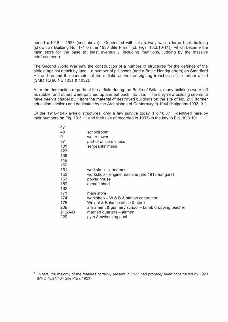
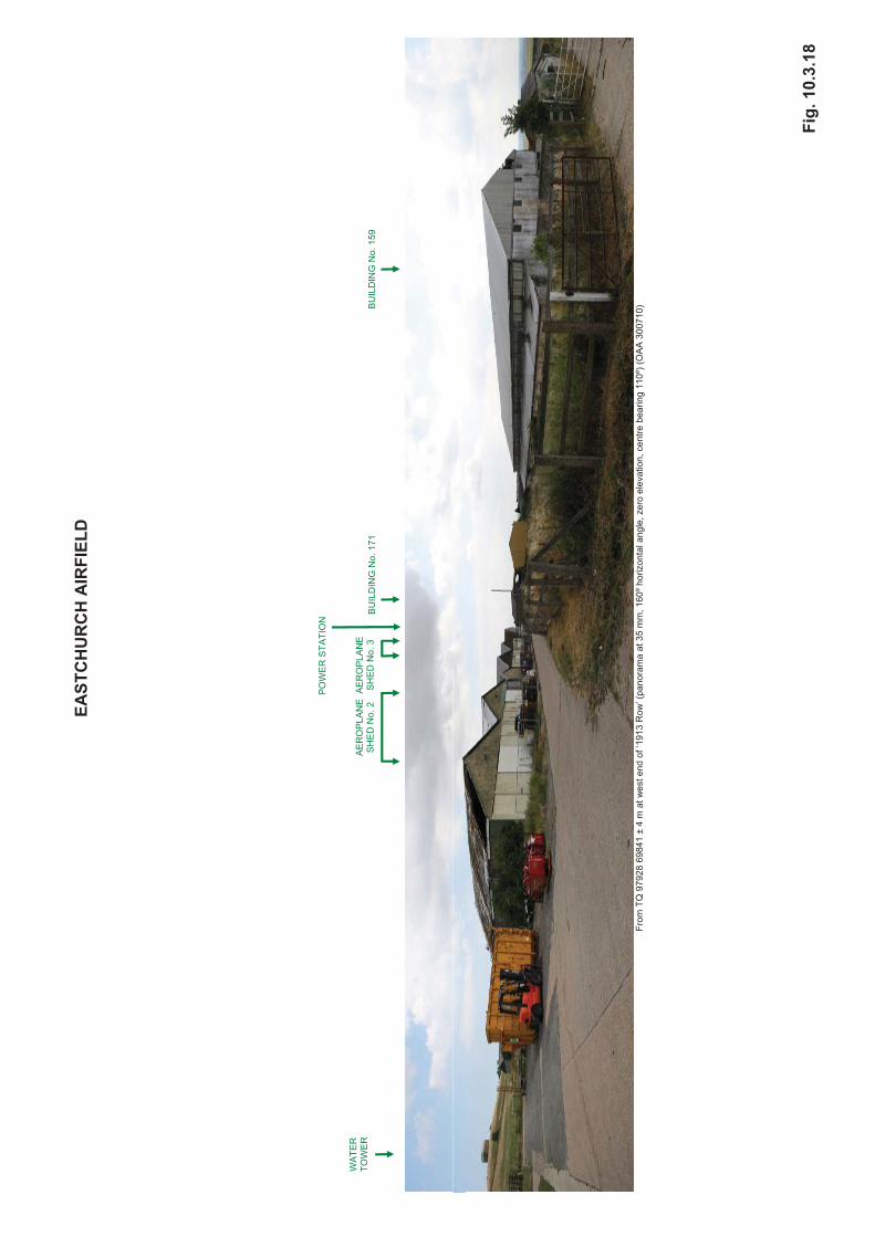
period c.1918 – 1923 (see above). Connected with this railway was a large brick building (shown as Building No. 171 on the 1933 Site Plan 3 (cf. Figs. 10.3.10-11)), which became the main store for the base (at least eventually, including munitions, judging by the massive reinforcement). The Second World War saw the construction of a number of structures for the defence of the airfield against attack by land – a number of pill boxes (and a Battle Headquarters) on Standford Hill and around the perimeter of the airfield, as well as zig-zag trenches a little further afield (SMR TQ 96 NE 1031 & 1032). After the destruction of parts of the airfield during the Battle of Britain, many buildings were left as rubble, and others were patched up and put back into use. The only new building seems to have been a chapel built from the material of destroyed buildings on the site of No. 213 (former education section) and dedicated by the Archbishop of Canterbury in 1944 (Halpenny 1993, 91). Of the 1916-1946 airfield structures, only a few survive today (Fig.10.3.1), identified here by their numbers on Fig. 10.3.11 and their use (if recorded in 1933) in the key to Fig. 10.3 10:
47 48 schoolroom 91 water tower 97 part of officers’ mess 101 sergeants’ mess 123 139 149 150 151 workshop – armament 152 workshop – engine machine (the 1913 hangars) 153 power house 159 aircraft shed 162 171 main store 174 workshop – W & B & station contractor 175 Weight & Balance office & store 209 armament & gunnery school – bomb dropping teacher 212/A/B married quarters – airmen 220 gym & swimming pool
3 In fact, the majority of the features certainly present in 1933 had probably been constructed by 1923
(MFC 78/24/404 Site Plan, 1923).

Maps and Documents Consulted The National Archives, Kew ADM 116/1292 Documents relating to water supply for Eastchurch Naval Aviation Yard,
1912-1915 AIR 1/2400/293/1 The history of Eastchurch Air Station, Sheppey, 1909-1926 (typed
manuscript, no date) AIR 2/19 Documents relating to construction of railway siding at Eastchurch, 1916 AIR 2/23 Documents relating to purchase of Eastchurch Air Station from Lt Col F.
McClean, 1918 AIR 2/367 Documents relating to married quarters, Eastchurch, 1920-1930 RAF Museum, Hendon MFC 78/24/404 Plan of RAF Eastchurch, 1923 MFC 78/24/406 Plan of RAF Eastchurch, 1933 B3772 Plan of RAF Eastchurch, showing bomb damage, 1940 MFC 78/24/415 Plan of RAF Eastchurch, 1948 P008392 Photo of RAF Eastchurch from the air c. 1930 Fleet Air Arm Museum, Yeovilton Three photographs of Eastchurch Airfield from the air, 1916 Bibliography Ashworth, C 1990 Action stations 9: military airfields of central southern and south-eastern
England (Patrick Stephens, Wellingborough) Brooks, R.J. 1998 Kent airfields in the Second World War (Countryside Books, Newbury) Croydon, B, n.d Early bird: a short history of how flight came to Sheppey (Publicity
Matters, Sheerness) Gollin, A, 1989 The impact of air power on the British people and their government 1909-
1914 (Macmillan, London) Halpenny, B.B. 1993 Action Stations 8: military airfields of Greater London (Patrick Stephens,
Yeovil) Roskill, S.W. 1969 Documents relating to the Naval Air Service Vol 1 1908-1918 (Naval
Records Society, London
Figure Captions 10.3.1 Buildings surviving in 2010 (Base Image: Google Earth 2003). 10.3.2 1909. OS 6-inch map (Sheet Kent XXI NE). 10.3.3 c.1910. McClean aerial view of Eastchurch Flying Field. 10.3.4 c.1910-11. Eastchurch Flying Field (after Croydon n.d.) 10.3.5 1913. Sheerness District. Eastchurch RN Aviation School. Site Plan. 10.3.6 1913. RN Aviation School. Distances of nearest living quarters from STW. 10.3.7 c.1916. Aerial photograph (RN Archives). 10.3.8 June 1916. Aerial photograph (RN Archives). 10.3.9 c.1918. Aerial photograph (RN Archives). 10.3.10 1933. Eastchurch Site Plan 273 MFC 78 24 406. 10.3.11 1933. Eastchurch Site Plan 273 MFC 78 24 415. 10.3.12 1934. Aerial photograph P008000 – P008999. 10.3.13 1940. Eastchurch Secret Plan. Ref. B3772. 10.3.14 1946. Aerial photograph. RAF 106 G UK 1444 4157 01 May 1946. 10.3.15 1953. Aerial photograph. RAF 82 726 0023 15 Feb 1953. 10.3.16 1996. Aerial photograph. NMR 154464 07 TQ 9869 15 05 June 1996. 10.3.17 From TQ 97883 69271 at edge of Eastern Turbine Field. (OAA 300710). 10,3.18 From TQ 97928 69841 at west end of ‘1913 Row’ (OAA 300710). 10.3.19 Inside the ‘Cow Shed’ (WWI hangar, 1933 No.159), from WSW, and from ESE
(OAA 300710). 10.3.20 Inside Aeroplane Shed No.2 from WSW and SW (OAA 200710). 10.3.21 Inside Aeroplane Shed No. 3 from W; 1913 Row from SE (OAA 300710). 10.3.22 WWII pillbox; multi-period building on the site of 1913 Shed No. IV from E (OAA
300710). 10.3.23 Men’s Quarters from the SE; WWI Water Tower, and WWII pillbox and Battle
Headquarters on Standford Hill from S (OAA 300710). 10.3.24 Mezzanine Office at west end of possible WWII Operations Room; view from
Mezzanine Office over possible WWII Operations Room (OAA 300710). 10.3.25 Upper Floor in 1923 Main Store and probable WWII Munitions Store (1933
Building No.171) looking SW; 1923 Main Store and probable WWII Munitions Store (1933 Building No.171) looking W (OAA 300710).
10.3.26 1923 Main Store and probable WWII Munitions Store (1933 Building No.171) looking W (apparent strafing damage);1933 Building No.209 from the SW (OAA 300710).
10.3.27 Southern wing of 1933 Building No.209 from W (OAA 300710). 10.3.28 Looking S from the Battle Headquarters. 30 April 2010.
(http://airfields.fotopic.net/c1872506_1.html) 10.3.29 ‘Cow Shed’ (WWI hangar, 1933 Building No. 159) c. 1950s ground level
photograph and recent aerial photograph (Trikeman, January 2009) (http://www.airfieldinformationexchange.org/community/showthread.php?1437-Eastchurch)


EAST
CH
UR
CH
AIR
FIEL
D
BU
ILD
ING
S SU
RVI
VIN
G IN
201
0
K
EY:
P
rese
nt b
y 19
13 (L
iste
d B
uild
ing)
P
rese
nt b
y 19
13
U
se in
191
3
P
ossi
bly
pres
ent b
y 19
13
W
WI f
eatu
re
P
ossi
bly
inco
rpor
atin
g W
WI f
eatu
re
P
rese
nt b
y 19
33 (p
roba
bly
by 1
923)
19
33 b
uild
ing
num
ber &
use
P
ossi
ble
WW
II us
e
W
WII
feat
ure
U
se in
199
9 (p
rison
)
(Bas
e Im
age:
Goo
gle
Ear
th 2
003)
Fig.
10.
3.1
MMAA
RRRR
II EEDD
QQUU
AARR
TT EERR
SS(( AA
II RRMM
EENN
))
22 1122 AA
22 1122
LL IIBB
RRAA
RRYY
22 1122 BB
EEDD
UUCC
AATT II
OONN
RREE
CCEE
PPTT II
OONN
22 0099
WWOO
RRKK
SSHH
OOPP
AARR
MMAA
MMEE
NNTT
&&GG
UUNN
NNEE
RRYY
SSCC
HHOO
OOLL
(( BBOO
MMBB
DDRR
OOPP
PPII NN
GGTT EE
AACC
HHEE
RR))
PPII LL
LL BBOO
XXSS
CCHH
OOOO
LL RROO
OOMM
CCLL EE
AANN
EERR
SS44 88
44 77
22 0099
AADD
MMII NN
SS
TT OORR
EESS
CCHH
AAPP
EELL
EEDD
UUCC
AATT II
OONN
SSEE
CCTT II
OONN
(( SSUU
BBSS
EEQQ
UUEE
NNTT LL
YYRR
EEBB
UUII LL
TTAA
SSCC
HHAA
PPEE
LL ??))
22 1133
WWAA
TT EERR
TT OOWW
EERR
99 11WW
AATT EE
RRTT OO
WWEE
RR
PP
II LLLL BB
OOXX
OOFF FF
II CCEE
RRSS
’’MM
EESS
SS(( PP
AARR
TT ))99 77
STO
RES
TT RRAA
II NNII NN
GGBB
AATT TT
LL EEHH
EEAA
DDQQ
UUAA
RRTT EE
RRSS
(( LLAA
RRGG
EELL YY
UUNN
DDEE
RRGG
RROO
UUNN
DD))
PP
II LLLL BB
OOXX
SSEE
RRGG
EEAA
NNTT SS
’’MM
EESS
SS11 00
11LL II
FF EERR
SSUU
NNII TT
AAEE
RROO
PPLL AA
NNEE
3SS
HHEE
DDNN
oo3
PPOO
WWEE
RRHH
OOUU
SSEE
PPII LL
LL BBOO
XX
AAEE
RROO
PPLL AA
NNEE
SSHH
EEDD
NNoo
22
11 5522
WWOO
RRKK
SSHH
OOPP
(( EENN
GGII NN
EEMM
AACC
HHII NN
EE))
??
PPII GG
HHOO
UUSS
EE
11 5511 WW
OORR
KKSS
HHOO
PP(( AA
RRMM
AAMM
EENN
TT ))
11 5522
VVEE
GGPP
RREE
PP
11 5533FF AA
RRMM
FF IITT TT
EERR
SS
EENN
GGII NN
EETT EE
SSTT II
NNGG
??
AAII RR
CCRR
AAFF TT
SSHH
EEDD
PPOO
WWEE
RRSS
TT AATT II
OONN
11 5599
CCOO
WWSS
HHEE
DD
11 4499
PPUU
LL PPSS
HHOO
PP
11 5500
SSOO
OOPP
SSRR
OOOO
MM??
WWHH
OOUU
SSEE
PPII LL
LL BBOO
XX
SSUU
BBSS
TT AATT II
OONN
22 2211
GGYY
MM&&
SSWW
II MMMM
II NNGG
PPOO
OOLL
GGYY
MM&&
PPOO
OOLL
22 2200
91
STO
RES
MMEE
NNSS
QQUU
AARR
TT EERR
SS
11 2233
WWOO
RRKK
SSDD
EEPP
TT
11 4466
CCAA
LL FFHH
OOUU
SSEE
STO
RES
FF IITT TT
EERR
SS
STO
RES
SSTT OO
RREE
11 6622
II NNDD
UUSS
TT RRII AA
LLWW
II PPEE
SS
11 7711
(( 1199 22
33 ))
MMUU
NNII TT
II OONN
SS??
MMAA
II NNSS
TT OORR
EE
MMAA
NNAA
GGEE
RRSS
OOFF FF
II CCEE
FF AARR
MMOO
FF FFII CC
EE
11 7755
11 7744
WWOO
RRKK
SSHH
OOPP
WW&&
BB&&
SSTT AA
TT IIOO
NNCC
OONN
TT RRAA
CCTT OO
RR
WWEE
II GGHH
TT&&
BBAA
LL AANN
CCEE
OOFF FF
II CCEE
&&SS
TT OORR
EE

Fig
.10.3
.2
Fig
.10.3
.3
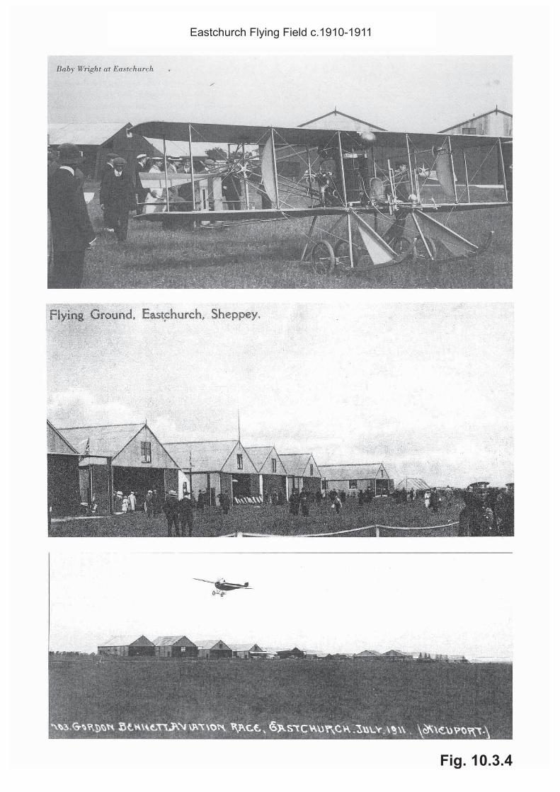
Fig. 10.3.4
Eastchurch Flying Field c.1910-1911

Fig
.10.3
.5

Fig
.10.3
.6

Fig
.10.3
.7

Fig
.10.3
.8

Fig. 10.3.9

Fig
.1
0.3
.10

Fig
.1
0.3
.11

Fig
.10.3
.12

Fig
.1
0.3
.13


Fig. 10.3.14

Fig. 10.3.15

Fig. 10.3.16


EA
STC
HU
RC
H A
IRFI
ELD
Fr
om T
Q 9
7883
692
71 ±
4 m
at e
dge
of E
aste
rn T
urbi
ne F
ield
(pan
oram
a at
35
mm
, 120
º hor
izon
tal a
ngle
, zer
o el
evat
ion,
cen
tre b
earin
g 01
0º) (
OA
A 3
0071
0)
Fig.
10.
3.17
TEM
PO
RA
RY
ME
T M
AS
T W
ATE
R
TOW
ER
B
UIL
DIN
G N
o. 1
46
BU
ILD
ING
No.
171
EAST
CH
UR
CH
AIR
FIEL
D
Fr
om T
Q 9
7928
698
41 ±
4 m
at w
est e
nd o
f ‘19
13 R
ow’ (
pano
ram
a at
35
mm
, 160
º hor
izon
tal a
ngle
, zer
o el
evat
ion,
cen
tre b
earin
g 11
0º) (
OA
A 3
0071
0)
Fig.
10.
3.18
WA
TER
TO
WE
R
AE
RO
PLA
NE
S
HE
D N
o. 2
A
ER
OP
LAN
E
SH
ED
No.
3
PO
WE
R S
TATI
ON
BU
ILD
ING
No.
171
B
UIL
DIN
G N
o. 1
59
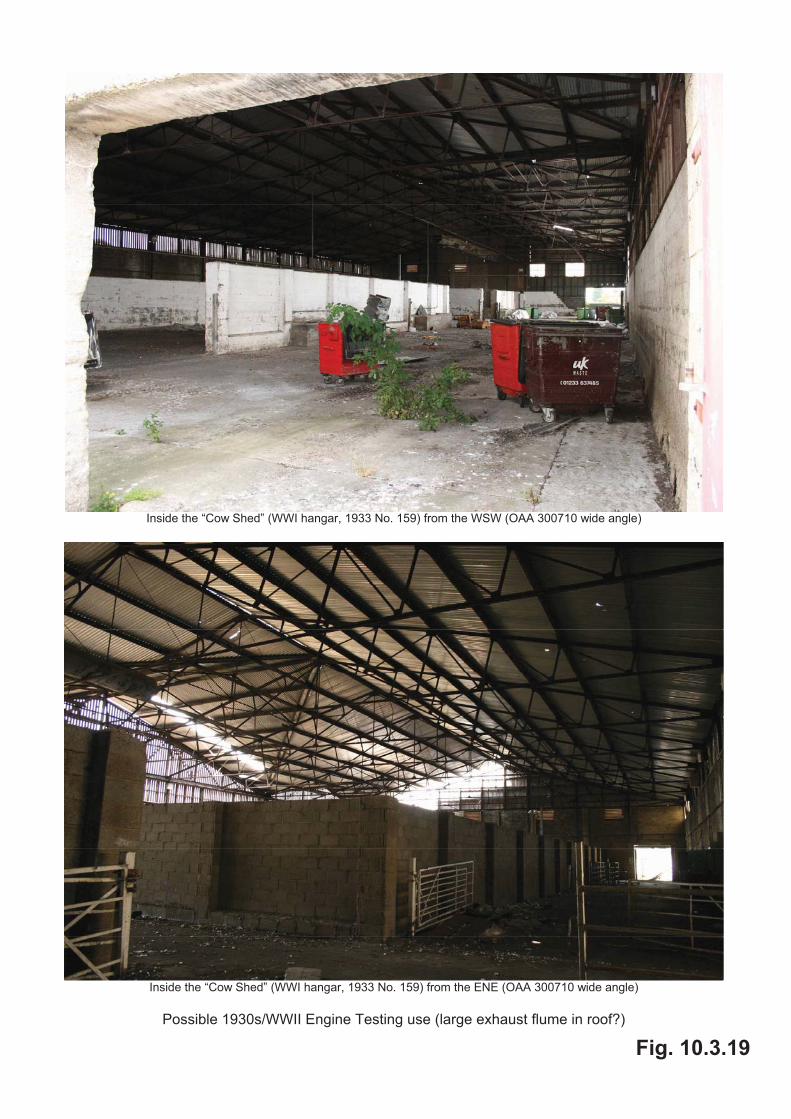
Inside the “Cow Shed” (WWI hangar, 1933 No. 159) from the WSW (OAA 300710 wide angle)
Inside the “Cow Shed” (WWI hangar, 1933 No. 159) from the ENE (OAA 300710 wide angle)
Possible 1930s/WWII Engine Testing use (large exhaust flume in roof?)
Fig. 10.3.19

Inside Aeroplane Shed No. 2 (western unit of pair) from the WSW (OAA 300710 wide angle) (Note original brickwork surviving in one panel only, replaced by breeze-blocks elsewhere)
Inside Aeroplane Shed No. 2 (eastern unit of pair) from the SW (OAA 300710 wide angle)
(Note original link between two shed pairs at least replaced by apparently modern breeze-block unit)
Fig. 10.3.20

Inside Aeroplane Shed No. 3 (northern part of unit pair) from the W (OAA 300710 wide angle)
(Unit pair refurbished as vegetable processing area, recently general store; note original brickwork on SW face of eastern unit of pair, elsewhere walls replaced by breeze-blocks)
1913 Row from the SE (OAA 300710 wide angle)
(Power Station nearest, Aeroplane Shed No. 3 (pair), modern link, Aeroplane Shed No. 2 (pair) farthest) (Note WWI shed added behind Power Station)
Fig. 10.3.21

WWII pillbox (just east of surviving 1913 buildings) (OAA 300710)
Current building, just south of 1913 Mens Quarters, from the E (OAA 300710 wide angle)
(heavily modified, with far section a modern addition, but apparently incorporating some pre-1933 elements and even, possibly, minor remnants of 1913 Shed No. IV)
Fig. 10.3.22

1913 Mens Quarters from the SE (OAA 300710 wide angle)
(Reroofing in progress; stoppage for asbestos and bat surveys)
WWI Water Tower and WWII pillbox (left) and battle headquarters (right, just ahead of and to right side of Water Tower)
on Standford Hill from the S (OAA 300710 wide angle)
Fig. 10.3.23

Mezzanine Office at west end of possible WWII Operations Room
(refit of WWI building, 1933 No. 149) (OAA 300710 wide angle)
View from Mezzanine Office over possible WWII Operations Room
(refit of WWI building, 1933 No. 149) (OAA 300710 wide angle)
Fig. 10.3.24
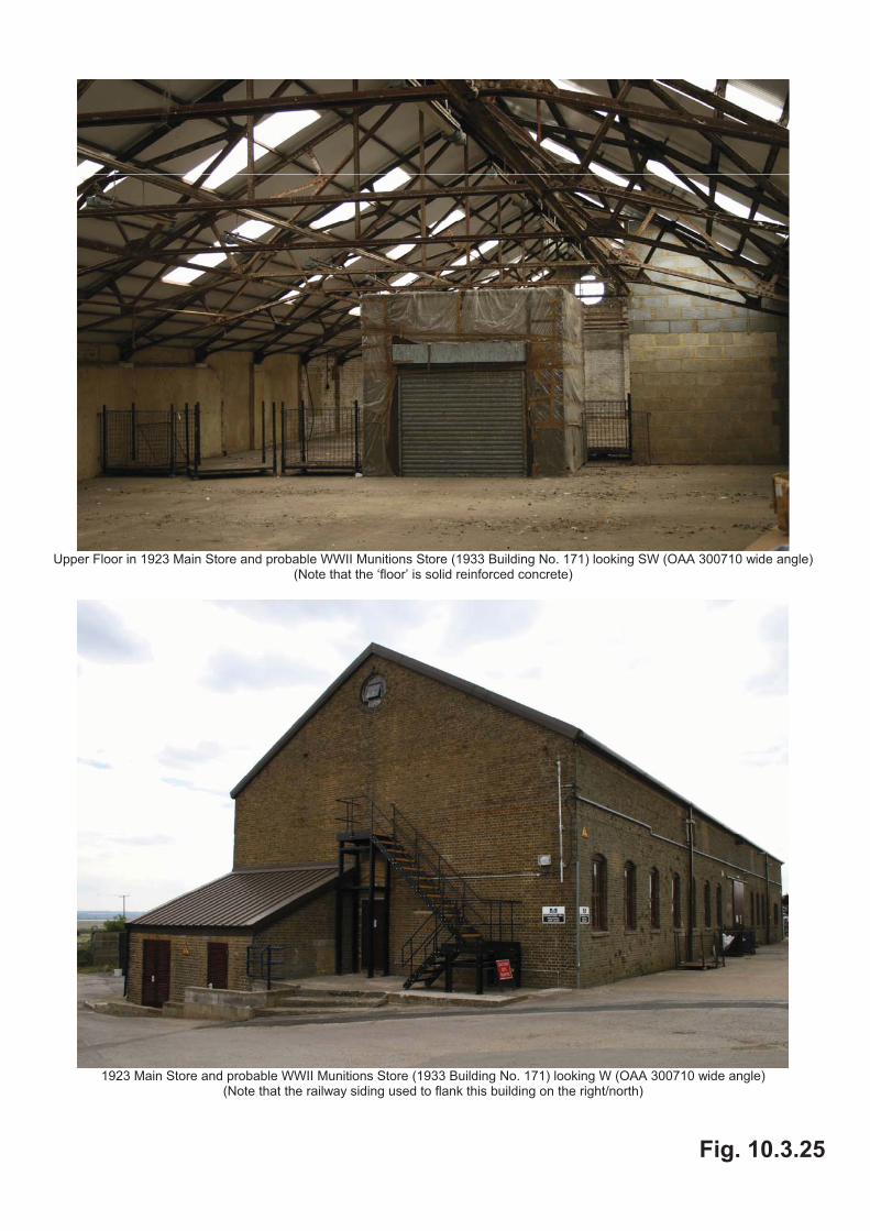
Upper Floor in 1923 Main Store and probable WWII Munitions Store (1933 Building No. 171) looking SW (OAA 300710 wide angle)
(Note that the ‘floor’ is solid reinforced concrete)
1923 Main Store and probable WWII Munitions Store (1933 Building No. 171) looking W (OAA 300710 wide angle)
(Note that the railway siding used to flank this building on the right/north)
Fig. 10.3.25
1923 Main Store and probable WWII Munitions Store (1933 Building No. 171) looking W (OAA 300710 wide angle)
(Note apparent strafing damage)
1933 Building No. 209 from the SW (OAA 300710 wide angle)
Fig. 10.3.26

Southern wing of 1933 Building No. 209 from the W (OAA 300710 wide angle)
(The original eastern link between the northern and southern wings seems to have been replaced by modern buildings)
Fig. 10.3.27

Looking south from the Battle Headquarters – 30 April 2010
http://airfields.fotopic.net/c1872506_1.html
Fig. 10.3.28
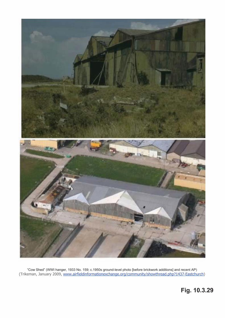
“Cow Shed” (WWI hanger, 1933 No. 159; c.1950s ground-level photo [before brickwork additions] and recent AP)
(Trikeman, January 2009, www.airfieldinformationexchange.org/community/showthread.php?1437-Eastchurch)
Fig. 10.3.29