Embed Size (px)
Citation preview

Historical and Architectural Survey Of
Newberry County, South Carolina
Newberry Opera House

HISTORICAL AND ARCHITECTURAL SURVEY OF
NEWBERRY COUNTY, SOUTH CAROLINA
FINAL REPORT
NOVEMBER 1, 2003
Submitted to:
Newberry County
Submitted by:
Jennifer Revels Palmetto Conservation Foundation
1314 Lincoln Street, Suite 213 Columbia, South Carolina 29201-3154
Newberry County Historical and Architectural Survey iii

CONTENTS I. PROJECT SUMMARY...........................................................................................................................2 II. PROJECT OBJECTIVES .....................................................................................................................3 III. SURVEY METHODOLOGY ..............................................................................................................4 IV. HISTORICAL OVERVIEW ...............................................................................................................6
Early Settlement in the South Carolina Backcountry ...........................................................................6 Conflict with the Cherokee ...................................................................................................................8 The Revolutionary War (1770–1785).................................................................................................10 County Establishment and Growth (1785–1865) ...............................................................................12 Railroad Development in the Upcountry ............................................................................................20 Civil War ............................................................................................................................................23 Community Growth and Industrial Expansion (1865–1960)..............................................................24 End of Small Town Life in Newberry County ...................................................................................31
V. ARCHITECTURE IN NEWBERRY COUNTY ...............................................................................34 Rural Architecture ..............................................................................................................................34
Dogtrots and Double Pen Houses ..............................................................................................36 The I-House ...............................................................................................................................37 Queen Anne ...............................................................................................................................40
Urban Architecture .............................................................................................................................41 Newberry....................................................................................................................................42West End & Newberry Cotton Mills..........................................................................................49 Mollohon Mill & Village ...........................................................................................................50 Oakland Mill & Village .............................................................................................................51Whitmire ....................................................................................................................................52Peak............................................................................................................................................54Kinards.......................................................................................................................................55Silverstreet .................................................................................................................................55Chappells....................................................................................................................................56Little Mountain ..........................................................................................................................57Prosperity ...................................................................................................................................61
VI. BIBLIOGRAPHY ...............................................................................................................................66VII. DATA GAPS ......................................................................................................................................71 VIII. RECOMMENDATIONS.................................................................................................................72
Rural Resources ..................................................................................................................................72 Newberry ............................................................................................................................................72 Whitmire .............................................................................................................................................73 Chappells ............................................................................................................................................73 Kinards................................................................................................................................................73 Peak ....................................................................................................................................................74 Silverstreet ..........................................................................................................................................74
IX. LOCAL PRESERVATION RECOMMENDATIONS ....................................................................75 Public Awareness................................................................................................................................75 Preservation Ordinances .....................................................................................................................75 Historic Preservation Tax Incentives..................................................................................................77 Land Use Planning..............................................................................................................................77
X. PROPERTIES AND HISTORIC DISTRICTS DETERMINED ELIGIBLE FOR LISTING IN THE NATIONAL REGISTER OF HISTORIC PLACES
XI. COMPILED PROPERTY INVENTORY
Newberry County Historical & Architectural Survey 1

I. PROJECT SUMMARY Palmetto Conservation Foundation conducted this historic resources survey of Newberry County, South Carolina. The work was undertaken on behalf of Newberry County and the City of Newberry and was funded by both the City and County administrators. The survey was conducted for the purpose of identifying properties and districts that should be considered for possible local designation and/or NRHP designation within the county. The survey will be utilized for the creation and promotion of economic incentives for rehabilitation, education, and heritage tourism, and the information will aid local governments in future planning activities and cultural tourism development. The boundaries for the survey were the Newberry County lines on the north, east, south and west. There were 1537 properties surveyed within a total area of approximately 631square miles. The results of the architectural survey indicate that there are potential historic districts within the town of Newberry. In addition, there were 650 properties surveyed in the rural areas of the county. Of these identified properties, 11 are considered individually eligible for listing in the NRHP. There were 581 residential, 122 commercial, 7 religious, 3 educational and two industrial properties identified within the municipal limits of the city of Newberry. One residential expansion district within the Newberry city limits was identified as being eligible for listing in the NRHP. There were 54 residential and 37 commercial properties identified within the municipal limits of the town of Whitmire. Of these identified properties, none are considered to be individually eligible for listing in the NRHP. There were 13 residential structures, one commercial building, one school, one entertainment venue, and one church identified within the municipal limits of the town of Silverstreet. Of these identified properties, none are considered to be individually eligible for listing in the NRHP. There were 12 residential structures, one commercial building, and one school identified within the municipal limits of the town of Chappells. Of these identified properties, none are considered to be individually eligible for listing in the NRHP. There were 17 residential structures, one commercial building, one church, one school, and two unidentified structures recorded within the municipal limits of the town of Peak. Of these identified properties, none are considered to be individually eligible for listing in the NRHP. There were five residential structures, two commercial buildings, and one church complex identified within the municipal limits of the town of Kinards. Of these identified properties, none are considered to be individually eligible for listing in the NRHP. Fieldwork for the project was conducted from May through October 2003. Ken Driggers, Director of Palmetto Conservation Foundation, supervised the survey, and Preservation Planner Jennifer Revels and contractor Ernest Shealy conducted the architectural survey and historical research.
Newberry County Historical & Architectural Survey 2

II. PROJECT OBJECTIVES The historic resource survey of Newberry County was undertaken in order to compile an up-to-date, accurate inventory of historic properties located within the County. The information was compiled in order to identify properties and districts that should be considered for possible local designation and National Register designation, as well as to aid the local governments in preservation planning and cultural tourism development. Information gathered during the survey will be used to evaluate the loss of historic properties over time and the effects of new development on the historic fabric in the county’s incorporated municipalities. The survey will also aid in future preservation-planning efforts by identifying historic properties and districts. This information can then be used when creating future zoning ordinances and local preservation ordinances. By establishing a clear picture of the history of the county and how its architecture fits into that history, residents and local government officials will be able to make informed decisions regarding the adaptive reuse or demolition of historic properties. They will also be able to utilize the history in order to create an effective heritage tourism plan.
Newberry County Historical & Architectural Survey 3

III. SURVEY METHODOLOGY
Field survey of Newberry County was undertaken in phases. The city of Newberry was surveyed initially, followed by the rural areas including the towns of Chappells, Kinards, Silverstreet, Peak and Whitmire. The intensive field survey began in May 2003 and was completed in October 2003. Before the survey began, the Survey Coordinator for the South Carolina Department of Archives and History assigned a block of survey numbers. Each surveyed property received a number that was noted in the top right hand corner of the final survey forms and alongside the property on the appropriate topographic maps. A surveyable property is defined as any property that is at least 50-years old and retains a good level of historical integrity. The National Register Criteria deals with “the quality of significance in American history, architecture, archaeology, engineering, and culture that is present in districts, sites, buildings, structures, and objects that possess integrity of location, design, setting, materials, workmanship, feeling, and association.” (National Register Bulletin 15, 1995:2). Any property eligible for listing in the NRHP must be significant under one or more of the following criteria:
Criterion A. Any property that is associated with events that have made a significant contribution to the broad patterns of our history. Criterion B. Any property that is associated with the lives of persons significant to our past. Criterion C. Any property that embodies the distinctive characteristics of a type, period, or method of construction, or that represents the work of a master, or that possesses high artistic value, or that represents a significant and distinguishable entity whose components may lack individual distinction. Criterion D. Any property that has yielded, or may be likely to yield, information important to our nation’s prehistory or history.
For a property to qualify for listing, it must meet at least one of the National Register Criteria listed above and retain historic integrity of those features necessary to convey its significance. During the course of the field survey, all roads within the proposed survey areas were walked or driven, and all existing, surveyable, and accessible aboveground structures were recorded in a Survey Database in Microsoft Access 97 format. In addition, black-and-white photographs were taken of every surveyed property and any related outbuildings. The film rolls and frames were logged, and the location of each property was noted on a USGS 7.5 Minute Quadrangle map. At the conclusion of the field survey, all properties were entered into a Geographic Information System (GIS) database to be added to the statewide information center located at the SCDAH. The GIS database
Newberry County Historical & Architectural Survey 4
includes the location of each recorded property as well as its historic name, historic use, and National Register eligibility. While the properties were being recorded, they were examined for National Register eligibility using the Criteria established by the U.S. Department of the Interior and the National Park Service as set forth in 36 CFR 60.4 (listed above). When possible, the owners of the house/business were consulted regarding any relevant history of the property in question, including old photographs and records pertaining to the structure. All information from these interviews, including photographs and documents, were recorded and included either on the final survey forms or in the final report. Once eligibility of individual properties had been determined, recommendations were made regarding possible designation of historic districts. According to the National Register Criteria, in order for a district to retain integrity as a whole, the majority of the components that make up the district’s historic character must possess integrity even if they are individually undistinguished. In addition, the relationships among the district’s components must be substantially unchanged since its period of significance. A component of a district is considered non-contributing if the structure has been significantly altered since the period of the district’s significance or the structure does not share the historic association of the district. All survey maps were clearly labeled with appropriate legends and depict the survey area boundaries, the locations of the surveyed historic properties (with survey numbers noted), and inaccessible areas. Boundaries for eligible districts are also noted and include the location of both contributing and non-contributing resources within each district. At the conclusion of the field survey, Jennifer Revels of the Palmetto Conservation Foundation accompanied Andrew Chandler and Brad Sauls from the South Carolina Department of Archives and History (SCDAH) on a field visit to the surveyed areas. At that time, all recommendations for National Register eligibility were examined and substantiated. All recommendations made by the SCDAH have been added into the final report. Potential threats to historic resources in the survey area were identified, and recommendations made for future preservation activities. These recommendations were developed in conjunction with the SCDAH.
Newberry County Historical & Architectural Survey 5

IV. HISTORICAL OVERVIEW
EARLY SETTLEMENT IN THE SOUTH CAROLINA BACKCOUNTRY South Carolina today, which consists of 31,113 square miles, is only a small portion of its original size. The state began as the province of Carolina in 1665. The original land grant given to the Lords Proprietors by King Charles II of England stretched north to south from the southern border of present-day Virginia to just above Daytona Beach, Florida and east to west from the Atlantic Ocean to the Pacific Ocean.1 As settlement increased, the boundaries of the original grant were whittled down until the 1990s when an agreement was finally reached with Georgia to draw the boundary between the two states down the Savannah River. In the mid-eighteenth century during the settlement of Newberry County, South Carolina had close to 75,000 residents as well as one of the most diverse European populations in British North America.2 Beginning in the 1740s and 1750s, Europeans of Scottish, Irish, English, and German descent moved into the South Carolina Piedmont. They were drawn to the area by Governor Robert Johnson's township program, which set aside areas beyond the low country to encourage European-American settlement, granting participants tax credits and free land. Since the overthrow of the Lords Proprietors in 1719, governmental officials had looked for ways to use the colony’s frontier as a buffer from Indian and Spanish invasion. Officials also wanted to balance the increasing slave population with free settlers. In the early eighteenth century, the majority of European settlements remained in the state’s low country. Coastal areas had developed well-organized societies that included seats of government, courts, schools, and churches and had accumulated a great deal of wealth. In contrast, the small townships throughout the midlands region were still in the frontier stages with sporadic development and little money. Beginning in the 1740s and 1750s, Europeans of Scottish, Irish, English, and German descent moved into the South Carolina Piedmont. They were drawn to the area by Governor Robert Johnson's township program, which set aside areas beyond the low country to encourage European-American settlement, granting participants tax credits and free land. Since the overthrow of the Lords Proprietors in 1719, governmental officials had looked for ways to use the colony’s frontier as a buffer from Indian and Spanish invasion. Officials also wanted to balance the increasing slave population with free settlers. Eleven settlements were established along rivers throughout the northern portion of the colony. In order to attract new settlers, the colonial government promised fifty acres of free land for each family member that settled in the backcountry, a waiver of all rent payments on the land for ten years, and additional funding for their food and
1 Walter Edgar, South Carolina: A History (Columbia: University of South Carolina Press, 1998), 1.
2 Edgar, South Carolina: A History, 52.
Newberry County Historical & Architectural Survey 6

transportation. The promise of new land and opportunities brought a large influx of immigrants to South Carolina, most arriving from England, Scotland, and Ireland.3 Pioneers in the backcountry, for the most part, came into South Carolina from the north, creating settlements that were independent of the low country. Despite occasional contact between the two groups, they remained largely separated. The land between the Broad and Saluda Rivers, including present day Newberry, Laurens, Union, and Spartanburg Counties, became an inviting location for settlement. Until the mid-1700s, the land had been the hunting grounds of the Cherokee and was largely appealing to the settlers for the richness of its landscape, which consisted of forests with little undergrowth and large hickory, oak, and pine trees.4 Many of the Scots-Irish pioneers in South Carolina were descendents of Scots Protestants who immigrated to the new world decades earlier seeking religious freedom. Originally settling in Pennsylvania, the group quickly became disillusioned with the Quaker government and traveled south to settle in the Carolinas. Unlike the Germans before
them, they did not seek to benefit from the free lands being offered by the state government. The Scots-Irish groups instead chose to settle in the northernmost portion of the state along a line that stretches from Lancaster to Abbeville.5 The first German immigrants to arrive in the upcountry settled in the Orangeburg and Amelia Townships. Some of these new settlers arrived through the port at Charleston, while others traveled
down the Great Wagon Road from Virginia and Pennsylvania. Orangeburg and Amelia were located in the center of the state, near present-day Lexington County. The German settlers took advantage of the area’s fertile soil and transformed their small settlements into the “breadbasket of South Carolina.”6 At the outbreak of the American Revolution, the area produced enough wheat for the entire colony with some left over for export. By
South Carolina Townships, as seen in Kovacik & Winberry, South Carolina.
3 Edgar, South Carolina: A History, 51-56.
4 Thomas H. Pope, The History of Newberry County, Vol. II (Columbia: University of South Carolina Press, 1992), 1.
5 Edgar, South Carolina: A History, 56.
6 Edgar, South Carolina: A History, 55.
Newberry County Historical & Architectural Survey 7

the end of the colonial period, the German inhabitants made up 5 percent of the South Carolina white population, settling for the most part in Orangeburg, Amelia, New Windsor, and Londonborough Townships. In some rural areas, German customs and language could be heard even into the early twentieth century.7 Newberry County was first settled by European Americans in the mid-eighteenth century, when people of Scots-Irish, German, and English descent began traveling south on the Great Wagon Road from Pennsylvania, Maryland, Virginia, and North Carolina into the upcountry of South Carolina. Present-day Newberry County was part of an area where German and Swiss immigrants formed the majority of the population. These settlers established farms and trading posts from the junction of the Broad and Saluda Rivers, stretching north to a line located just south of the present city of Newberry, which became known as the Dutch Fork, despite the fact that no Dutch immigrants ever settled there. It is possible that the term derived from “Deutsch volk” meaning “German folk”, a term that was used in both Pennsylvania and South Carolina to signify German-speaking people. The word “Deutsch” could have easily been heard as “Dutch” and “volk” or “folk” was most likely converted by the English-speaking inhabitants to “fork.”8
Thomas Brown, Jacob Derer, Caspar Faust, John Jacob Fridig, John Jacob Geiger, John Hamelton, and John Matthys were the earliest settlers in the Dutch Fork area in 1744. By 1748, more than 50 people were living in the area and by 1749 there had been 125 warrants for 21,150 acres of land with a population of 423 persons. In 1759, eighteen hundred German settlers and one thousand British settlers occupied the Broad River Valley.9
CONFLICT WITH THE CHEROKEE The Cherokee are an Iroquoian-speaking group who migrated from Tennessee and North Carolina into the northwestern section of South Carolina in the sixteenth century. They occupied and hunted in lands that ranged from the Blue Ridge Mountains south to Abbeville County and southeast to the Broad River, where their territory abutted that of the Catawba. Their established towns remained in the more northern sections of their territory beyond the mountains, with only a few small towns in present-day Oconee County representing the most southern or lower part of their lands. Areas of Laurens County, similar to Abbeville County, were probably used as hunting grounds and for temporary encampments. Despite their growing numbers, residents in the backcountry remained isolated from the everyday activity in South Carolina’s coastal settlements. The frontier settlements had little interaction with the state government in Charleston, only occasionally coming in contact with a justice of the peace or tax assessor as they made rounds through the area. Roads in the upcountry were few and those that had been constructed made travel 7 Edgar, South Carolina: A History, 55-56.
8 Pope, The History of Newberry County, Vol. II, 6.
9 Pope, The History of Newberry County, Vol. II, 6.
Newberry County Historical & Architectural Survey 8

difficult. Travel estimates from the frontier towns to Charleston (on horseback under good conditions) ranged anywhere from ten days to two weeks, depending on the point of origin.10 Because of their distance from the coast and its protection, men living in these frontier townships were organized into militia units by the state legislature, but were in place in the low country for the most part to quell slave revolts and were not trained for serious combat. This relatively untrained militia proved useless in the face of the Cherokee Indian attacks that began in the late 1750s.11 By the mid-eighteenth century, attacks by the Cherokee became so frequent that further settlement in the upcountry was discouraged by the state legislature. Frightened residents of the Ninety-Six district took refuge in forts that were scattered along creeks and rivers in the area. Beginning in 1759, several stockade forts including Turner’s Fort and Brooks’ Fort (on the Bush River near the present day city of Newberry) were built in Newberry County along the Broad, Enoree, and Bush Rivers as refuges for scattered inhabitants of the Dutch Fork. Cherokee attacks on towns such as Long Cane and Ninety-Six drove settlers into the forts for protection. Within the forts, disease and corruption were rampant. Those who took refuge withstood the vicious attacks, but at a high price. The commanders embezzled money provided by the state legislature for the refugees, and in turn charged high prices for essential food and supplies while militiamen outside the forts pillaged their abandoned houses.12 In May 1760, Colonel Archibald Montgomery and 1,200 regular Scots highlanders marched from Charleston with the purpose of expelling the Cherokee from the midlands. Montgomery and his men were ambushed and, after suffering only a handful of losses, retreated from the area. A mass exodus of settlers from the upcountry followed Montgomery’s defeat as residents fled to Saxe Gotha Township or further toward the coast. Colonel James Grant led a second campaign against the Cherokee in 1761. Grant raided the Cherokee lands, setting fire to Indian camps and leaving fifteen villages in ruin. The Treaty of Charleston signed later that year officially ended the Cherokee War and the Indian occupation of the midlands.13
There was a large wave of immigration to the South Carolina backcountry following the Cherokee War, which resulted in a greater influx of white settlers as compared to the township program established forty years earlier. In the post-war years between 1760 and 1770, the percentage of the colony's white population living in the backcountry rose from about 50 percent to 75 percent.14 While the treaty ended any threat that the Indians posed to the upcountry settlers, the post-war years were filled with chaos and lawlessness. Abandoned homes across the
10 Edgar South Carolina: A History, 205.
11 Edgar South Carolina: A History, 205.
12 Edgar, South Carolina: A History, 206.
13 Pope, The History of Newberry County, Vol. I, 21-29.
14 Weir, Colonial South Carolina, p. 209.
Newberry County Historical & Architectural Survey 9

upcountry invited theft and vagrants stole horses and cattle on a regular basis.15 The existing form of colonial government failed to bring the derelicts under control and local authorities were powerless to stop it. The closest courts were more than 100 miles away in Charleston, and local authorities, lacking real jurisdiction, could only issue warrants. Prosecutors and witnesses had to make the long trip to Charleston for trials, which from some points in the upstate could take up to two weeks, with no guarantee of a conviction.16 The situation improved with the passage of the Circuit Court Act of 1768, which divided the state into six districts, establishing the Courts of General Sessions and Common Pleas in each. Following closely behind was the Circuit Court Act of 1769, which was an improved version of the previous year’s act. This legislation divided the state into seven judicial districts: Ninety-Six, Orangeburg, Cheraws, and Camden Districts would serve the residents of the upstate, with Beaufort, Charleston, and Georgetown serving along the coast. Soon after the local courts were established, residents of the Ninety-Six District, which included present day Newberry, Edgefield, Abbeville, and Laurens Counties, began meeting to lobby for independence from Charleston’s control and for legislation that would aid local improvements.17
The Revolutionary War (1770–1785) Until the 1760s, the Newberry County area was part of the parish system established by the colonial government that afforded little assistance to residents of the backcountry. Although an operating judicial system was not established in the backcountry until after the Revolutionary War, districts were organized in 1769. Newberry County was part of the Ninety Six District, which comprised a large area including present-day Abbeville, Greenwood, Laurens, McCormick, and Edgefield Counties.18 Because of its proximity to Cherokee territory, Newberry County was drawn into the uncertain politics of the early Revolutionary War. Because of their distance from the heated politics of the coast, most back country residents were unaware of the grievances carried by their coastal neighbors against the mother country. Many back country residents remained loyal to England, particularly those who had received large grants of land from the King19. Upcountry residents were also concerned by the lack of fair representation given by their coastal neighbors, the latent establishment of circuit courts, and the failure of state leaders to provide schools and churches in the upstate. Rumors of the Cherokee planning to take advantage of the colony's political divisions, ally with local British sympathizers, and attack backcountry settlements were rampant. Others suggested that the Low Country government would incite the Cherokee to subdue the back settlements, which largely supported the British.
15 Pope, The History of Newberry County, Vol. I, 24.
16 Pope, The History of Newberry County, Vol. I, 24.
17 Pope, The History of Newberry County, Vol. II, 31-33.
18 Edgar, South Carolina, pp. 212-221; Theresa M. Hicks, South Carolina: A Guide to County Records (Columbia: Peppercorn Publications, Inc., 1998), p. 168.
19 Jacobs, The Scrapbook, p. 8
Newberry County Historical & Architectural Survey 10
South Carolina’s first Provincial Congress met in 1775 to discuss the importation agreement proposed by the Continental Congress in Philadelphia. The agreement sought to prevent the importation of British goods into the American colonies. Responding to the uncertainty of loyalty in the backcountry, the Provincial Congress in Charleston sent a delegation to Ninety Six in an attempt to win support from the locals. The group of representatives was led by William Henry Drayton. The first of three meetings took place in the Dutch Fork at McLaurin’s Store. Drayton later noted in his journal that the meeting went poorly and little progress was made. The remaining two meetings were equally as unproductive. Residents were not hostile toward the provincial government; they just wanted to be left alone. In the end, the two parties reached an agreement; the upcountry residents would sign an agreement stating that they would remain neutral in exchange for the promise that they would no longer be bothered with talk of revolution.20 The treaty did not hold, however, and violence continued in the area as groups fought over militia supplies and worried about Cherokee allegiances. The second Provincial Congress was held in November 1775. As South Carolina prepared for war, the state became the second colony to adopt a constitution, electing John Rutledge as president. In 1778, the Constitution was officially adopted. The new document called for the replacement of the Legislative Council with a Senate that would be elected by the people. In turn, the General Assembly became the House of Representatives and the president became the governor. The Senate and House of Representatives formed South Carolina’s bicameral legislature in which, for many years, the Lower House would have the decisive voice. Under this new system of democratic government, any free white male who believed in God, was at least 21 years of age, who had lived in South Carolina for at least one year before Election Day, and owned either fifty acres of land or a town lot was allowed to vote.21
In the years immediately preceding the war and throughout the Revolution, upcountry residents and the state legislators were in constant conflict. It was in the Ninety-Six District where the second battle of the war would be fought, resulting in the first casualty of war in South Carolina. The death of one of their own was still not enough to sway the opinions of backcountry loyalists. It was not until the capture of Charleston by the British in May 1780 that the opinions of many who had remained loyal to the British changed. Governor Rutledge was forced from the city while British soldiers and militia brutally punished the patriots that stayed behind, burning their homes and killing many. The cruelty exhibited by the British troops toward residents of Charleston and the Low Country angered South Carolinians. A group of loyalists from Ninety-Six District immediately formed a militia with six separate regiments. It has been estimated that in the Ninety-Six District alone there were over 1,400 widows and orphans by the end of the war.22
20 Edgar, South Carolina: A History, 221-224.Farley, Foster. Newberry County in the American Revolution. Newberry County Bicentennial Committee: Newberry,
South Carolina, 1975. p. 6-7.
21 Pope, The History of Newberry County, Vol. I, 36-41.
22 Pope, The History of Newberry County, Vol. I, 47.
Newberry County Historical & Architectural Survey 11

Over 250 battles were fought in South Carolina during the Revolutionary War, more than almost any other state. Ten of those battles were fought in Newberry County, more than in any other county in South Carolina with the exception of Charleston and Berkeley Counties. In March, 1781, Colonel Roebuck and Colonel Henry White along with 150 men attacked the British forces at William’s Fort on Mudlick Creek, just north of Chappells in southwestern Newberry County. After fighting for an hour, the Patriot forces left victorious. In May of that same year, the Battle of Bush River took place, pitting Colonel John Thomas against a group of Loyalists. In addition to the numerous battles that took place in the backcountry, residents were ever fearful of the horrible cruelty of the British forces. The Hayes Station massacre is one such example that took place in Laurens County, eight miles southwest of Clinton between the Belfast and Milton settlements. William Cunningham was an officer for the British armies and was notorious for his cruelty, earning him the nickname of Bloody Bill. During his rampage through Laurens and Newberry Counties, Cunningham stopped at the home of John Caldwell which is located off of present day Hwy 56 between Mudlick and Mills Creeks. Caldwell, who had Cunningham arrested and tried by court martial for attempting to leave the service several years before, was killed in an attempt by Cunningham to avenge his treatment during the trial. After killing Caldwell, Cunningham continued to Hayes Station, where he set the tavern on fire and his men killed 14 of the inhabitants, allowing only seven to survive. 23 At the war’s conclusion, South Carolina slowly began the process of reestablishing its government. At the close of the Revolution, Ninety-Six, Orangeburg, Cheraw, and Camden Districts, created in 1769, had become too large to effectively govern. In 1783, concerned that the majority of the free white population was concentrated in the four districts with the least representation, the state government decided to divide the existing districts into smaller counties of no more than 40 square miles. In 1785, the Ninety-Six District became Edgefield, Abbeville, Laurens, Spartanburg, Union, and Newberry (then spelled Newbury) Counties.24 The following year, the legislature voted to move the state’s capital from Charleston to a new town that would be constructed in a centralized location along the banks of the Congaree River. After a great deal of debate, it was decided that the new town would be named Columbia, a name that symbolized the new nation.25
COUNTY ESTABLISHMENT AND GROWTH (1785-1865) In addition to the creation of the counties and the establishment of a new capital, a county court act was also passed. The 1785 act gave county courts jurisdiction in cases of common law up to fifty pounds and in criminal cases unless the act was punishable by death or corporal punishment. The courts also had responsibility of the roads, bridges and
23 Foy, Laurens County Sketchbook, pp. 9-11; Jacobs, The Scrapbook, pp. 594-595; Edgar, South Carolina, pp. 212-221. Farley, Newberry County in the American
Revolution, pp. 27-29.
24 Pope, The History of Newberry County, Vol. I, 54.
25 Edgar, South Carolina: A History, 248.
Newberry County Historical & Architectural Survey 12

ferries, the power to levy taxes, and “license tavern owners and fix prices for whiskey.”26 Beginning in 1787 the Newberry County Courthouse began to probate wills and record deeds, eliminating a trip to Ninety-Six or Charleston to file the necessary paperwork. Each of these actions brought the backcountry residents closer to the inner workings of the state.27
In 1798, the state was divided into judicial districts with one court located in each. As of 1 January 1800, the county courts and the courts of common pleas and general sessions were abolished.28 The county court system, as it had existed, was a separate administrative body that handled all local affairs. The system functioned as a distinct and separate form of government. The establishment of judicial districts made it possible for the general assembly to control the government, allowing them to serve as election districts and a means to hold court.29 Although the creation of smaller counties and the removal of the state capital from Charleston brought the backcountry into the realm of state government, the area remained isolated from the main currents of South Carolina society. The introduction of cotton cultivation and exposure to evangelical Christianity in the late eighteenth century would change the face of the backcountry, which had long been excluded from the export-based economy that the coastal planters were dependent upon. The introduction of short-staple cotton gave the backcountry planters a cash crop with a high market value. The subsequent arrival of evangelical Christian missionaries began to solidify the budding society by helping to establish houses of worship. Church services brought together isolated rural households, establishing a community identity and code of conduct.30 Cotton and Christianity, in many cases, directly contradicted one another. Eli Whitney’s cotton gin made it possible to process cotton on a grand scale, increasing the use of slave labor. The Methodist denomination was anti-slavery and would not allow its members to be slaveholders. The Methodist General Conference convened in 1784 and decreed that holding slaves in one’s possession was an offense punishable by expulsion from the church. In addition, in 1800 they forced all of their clergy to sell any slaves that they might be holding. Ministers of the Presbyterian Church also preached on the evils of slavery but were not as stringent in their membership requirements. Opposing views of the congregations and the clergy dissuaded many upcountry farmers from joining churches during the late eighteenth century.31 Despite the initial protests from backcountry congregations to the institution of slavery, the widespread opposition had ceased by the early nineteenth century. The Quaker community, however, took a more hardened stance. Adamantly opposed to slavery, the group chose to leave Newberry County for Ohio, Indiana, and Illinois in the early 1800s.
26 Pope, The History of Newberry County, Vol. I, 61.
27 Pope, The History of Newberry County, Vol. I, 61-63.
28 Pope, The History of Newberry County, Vol. I, 65.
29 Pope, The History of Newberry County, Vol. I, 73.
30 Lacy Ford, Origins of Southern Radicalism: The South Carolina Upcountry 1800-1860 (Oxford: Oxford University Press, 1988), 1-5.
31 Edgar, South Carolina, 259. Pope, The History of Newberry County, Vol. I, 80-89.
Newberry County Historical & Architectural Survey 13

Quaker minister Zachary Dicks visited the county in 1803 preaching against slavery and pointing to slave uprisings in Santa Domingo and Haiti as a warning of what was to come. It was shortly after his visit that Newberry County’s Quaker community and many others left the state.32 The slave population continued to grow and the black community outnumbered white residents well into the early twentieth century.33
Prior to the introduction of the cotton gin, most upcountry farmers concentrated on subsistence crops. The landscape was dotted with small family farms that existed to provide the owners with food while producing little capital. Indigo cultivation brought wealth to the area, but the Revolution had introduced overseas competition and resulted in the loss of the Crown’s bounty. As the indigo industry waned tobacco became the main cash crop for the backcountry and, despite poor yields, would remain so until shortly after 1800. The introduction of the cotton gin in the late 1790s created a shift in the backcountry’s economic status. Staple crops that were not easily adaptable to the soil and climate of the upstate, such as rice and Sea Island cotton, had generated a large percentage of South Carolina’s early wealth. Short staple cotton and the cotton gin allowed upstate farmers access to the wealth and opportunities that had been previously reserved for coastal planters. The possibility of making a large profit from the sale of their cotton crop was the driving force behind the shift in interest. In 1818, cotton sold for 30.8 cents per pound and by 1826, cotton was Newberry County’s staple crop.34 Cotton production, unlike rice production, required very little capital investment. All that was required to begin production was land, tools for planting, and machines for processing the cotton after it was grown. Because one acre of planted land could yield anywhere from 150 to 250 pounds of cotton, it was possible for farmers with relatively little land to produce a cash crop that would in turn lead to larger, more sophisticated homes and larger land holdings. The only limitation to the small cotton farmer was harvesting. On an average day, a single person could pick anywhere from fifty to eighty pounds of cotton.35 The prosperity that accompanied the upstate cotton boom gave residents a feeling of optimism and brought many households into the slaveholding ranks.36 In 1800, black residents totaled 16 percent of Newberry County’s population. That figure increased to 33 percent by 1820, 49 percent by 1830, 55 percent by 1840, and 60 percent in 1850.37 After 1830, the free white population began to decrease as cotton lands became overworked and planters moved west and south to new territory in Mississippi, Alabama, and Texas. The predominantly agricultural and trade-based society of Newberry grew into one of the state’s largest cotton producing areas. With this new interest in upstate cotton production, South Carolina was continuing its economic pattern—an agricultural economy focusing on staple crops produced for the world market by black slave labor. In
32 Edgar, South Carolina, 294. Pope. The History of Newberry County, Vol. 1. 83-84.
33 Census of 1810, Newberry County
34 Ford, Origins of Southern Radicalism, 5-8.
35 Edgar, South Carolina: A History, 271.
36 Ford, Origins of Southern Radicalism, 19-21.
37 Pope, The History of Newberry County, Vol. I, 113.
Newberry County Historical & Architectural Survey 14

contrast to the rest of Newberry County, the Dutch Fork area remained largely an area with small farms and few slaves.38 Prior to 1800, South Carolina exported approximately 94,000 pounds of long staple cotton from the coastal counties. By 1800, export numbers skyrocketed to over 20 million pounds—most of which was the new short staple cotton grown in the upstate regions. Cotton brought wealth not only to those who cultivated it, but also to those who helped to process the crops. In many small towns, business savvy entrepreneurs opened public gins and warehouses where farmers from the surrounding countryside could come and have their cotton processed and stored for a percentage of their profit. Because the South Carolina community relied so heavily on cotton production during this period, its prosperity rose and fell with the fluctuating cotton market.39
The vast majority of persons who lived in Newberry County in the early to mid-nineteenth century lived on farms and plantations. Fed by the British textile market, Piedmont farmers purchased the greatest amount of land and slaves they could afford in order to grow cotton.40 The dominance of the crop spread so quickly, and to such a great extent, that as early as the 1820s, agricultural reformers began to suggest alternate crops and methods to curtail soil exhaustion. Robert Mills wrote of soil exhaustion in 1826, "The same erroneous system of cultivating our lands is pursued in this district as in others, so destructive to the soil and detrimental to the permanent advantage of the country…. We wish to see them giving back to the soil some portion of nourishment which they take from it."41 The change from small farms to larger plantations is further evidenced in the census records for Newberry County. The largest slaveholder in the district was Chancellor Johnstone, who owned 183 slaves in 1850. Other large slaveholders included John Summer, owner of Pomaria (site 1203), who owned 109; Jacob Kibler, owner of Hardy Plantation (site 1314), who had 68 slaves; James Epps, owner of Jasper Hall (site 1556), who had 53 slaves; and Francis B. Higgins (site 0897) who owned 50 slaves. By 1860, there were approximately 840 farms, 23 of which consisted of 500-1,000 acres of land and eleven farms that exceeded 1,000 acres. These farms were operated by 13,695 slaves. The average number of slaves owned continued to increase, a trend that remained constant until the Civil War.42 Newberry is positioned geographically among the lower Piedmont counties, similar in climate to Edgefield and Fairfield. In the nineteenth century Newberry County had similar soil conditions but larger cotton-growing and slave-holding areas as compared to upper Piedmont counties like Anderson, Greenville and Spartanburg, where small- to medium-size farms and a white majority remained. 38 Pope, The History of Newberry County, Vol. I, 112-113.
39 Edgar, South Carolina: A History, 270-273.
40 Kovacik and Winberry, The Making of a Landscape, pp. 88-90.
41 Mills, Statistics, p. 610.
42 Slave Schedule for 1850, Agriculture of the United States in 1860 compiled from the official returns of the Eighth Census, Washington, Government Printing
Office, 1864, pp 214, 237, 128-131. Pope, Thomas. The History of Newberry County, Vol. I. pp 113-114.
Newberry County Historical & Architectural Survey 15

For those who were enslaved, life on upcountry cotton plantations differed greatly from that on lowcountry rice plantations. Slaves were usually forced to work in a gang system, in which they worked set hours each day, usually sunrise to sunset. These schedules differed from the task system, in which slaves were assigned a task to accomplish each day, and were often able to use their free time if the task was accomplished early.43 Slave houses were two or three-room frame or log buildings with stone, brick, or stick chimneys, scattered around the plantation rather than on a street. Overseers lived with their families on the plantation in larger or more elaborate housing than that given to the slaves.44 Few examples of antebellum plantation buildings remain as many have been lost or modified at a later date to serve alternate purposes. The increasing practice of cotton monoculture and slavery acted to change the landscape of Newberry County. As more farmers began to plant cotton, wooded areas were cleared to create fields and frame slave cabins and outbuildings such as barns and cotton presses were constructed to support production. As their finances increased, farmers began to replace their small log houses with larger, two-story frame houses, often in a form known as the Carolina I-house.45 Documented examples of this building type include Hardy Plantation near Maybinton, built ca. 1824 (Site 1314); the Chalmers-Brown House (Greenfield Farm), built ca. 1840 (Site 1473); the Summer-Huggins House (Pomaria), built ca. 1825 (Site 1203); Site 1166 near Little Mountain and Sites 1157 and 1158 both constructed ca. 1850 along Kibler’s Bridge Road. Many of these early houses have some outbuildings surviving, built in various years through the mid-twentieth century and used for differing purposes. These outbuildings include well houses, smokehouses, barns and tenant houses. Several local planters gained enough wealth to build more elaborate homes. These include Jasper Hall (Site 1556), a two-story frame building just south of Whitmire, constructed in 1857 by Dr. James Epps. John Henderson built a Greek Revival cottage on Henderson Ferry Road around 1850 (Site 1302). Site 1548 near Brown’s Crossroads was constructed ca. 1860, possibly by the Brown Family, and has a two-story porch with decorative detailing, paired end chimneys, and elaborates entry. The many large I-houses and several of the more elaborate homes reflect the prosperity of the 1850s cotton boom. Newberry led the way for other lower Piedmont counties in cotton production in the first decades of the nineteenth century. The average number of improved acres per farm more than doubled in this decade, and cotton production increased while corn production and swine raising decreased as it did throughout the Piedmont. Historian Lacy K. Ford explains this trend by the increase in cotton prices and access to reasonably priced market goods via the railroad.46
43 Edgar, South Carolina, pp. 311-316.
44 George P. Rawick, ed., The American Slave: A Composite Autobiography (Westport, CT: The Greenwood Press, Inc., 1979), Supplement Series 1, Vol. 11, pp.
126-139, http://newdeal.feri.org/asn/asn09.htm. New Deal Network, http://newdeal.feri.org, accessed 6 February 2002.
45 Kovacik and Winberry, The Making of a Landscape, p. 89.
46 Ford, Origins of a Southern Radicalism, pp. 219-222.
Newberry County Historical & Architectural Survey 16

Accompanying the cotton boom during the first portion of the nineteenth century was a period of statewide nationalism and expansion. South Carolina congressional representatives were strong supporters of the War of 1812 and the Monroe Doctrine. They also greatly favored internal improvements including new roads and canals that would help to connect the upper and lower parts of the state—areas that had been separated for years both physically and economically. In 1818, the General Assembly established a Board of Internal Improvements to oversee a $1 million program of roads and canals to improve the state’s transportation network, beginning a major transportation enhancement campaign.47 The construction of locks and canals began in order to make rivers in the upstate navigable, and construction started on a state road from Charleston to North Carolina that ran along the Broad River and through the Newberry District.48 The state’s canal system was a great disappointment. The plan proposed by the Board of Internal Improvements called for eight canals. Four were to be located on the Catawba and Wateree Rivers above Camden. The Lockwood and Columbia Canals along the Broad River were intended to open up traffic 110 miles north of Columbia and the Saluda and Dreher Canals along the Saluda River were meant to open up river traffic to Laurens and Abbeville.49 All eight canals were completed and totaled 25 miles of canals and 59 locks that connected every district in the state except Greenville. The system was plagued with problems from the outset. Shoddy construction and damage from flooding resulted in the poor operation of the locks and by 1840 six of eight canals were abandoned. Public disinterest added to operational problems. Lack of use by the public resulted in a failure to generate the needed revenue to pay the lock keepers’ salaries.50
The state road fared little better than the canals. The new corridor was planned as a toll road running from Charleston through the upstate to North Carolina. The road from Charleston to Columbia was completed in 1829, but residents refused to pay what they considered exorbitant tolls and instead traveled along back roads. The road was only heavily used later when the tolls were lifted. By 1837, the South Carolina economy was experiencing a downturn and was in need of an effective means of transporting goods from the upcountry to the coastal region.51
Like so many other frontier towns at the end of the eighteenth century, there was a small village that had developed around the Newberry Court House. John and Henry Coate owned the land around the Court House and in the last decade of the eighteenth century, they began to lay out town lots. James Campbell, Frederick Nance, Dr. Jacob Robert Brown, and Colonel Robert Rutherford were some of the first men to purchase lots around the public square. Nance was the first resident of the town, having been appointed Clerk of Court in 1794 in addition to establishing his store and doing business there before 1800.52
47 Edgar, South Carolina: A History, 282.
48 Pope, The History of Newberry County, Vol. I, 71-73. Edgar, South Carolina: A History, 281-284.
49 Edgar, South Carolina: A History, 282-284.
50 Ford, Origins of Southern Radicalism, 16.
51 Derrick, Samuel. Centennial History of the South Carolina Railroad (Columbia: The State Company, 1930), 1-19.
52 Pope, Thomas, History of Newberry Co. Vol. I, pp. 91-93.
Newberry County Historical & Architectural Survey 17

Deeds for the lots sold by the Coate’s indicated that town encompassed approximately 25 acres. Each lot was placed around the public square where the Court House and jail were located. The early streets were each 33 feet wide and were marked on the plat by the destination point on that road. For example: the present day College St. was labeled “the Street to Charleston” and Boundary Street was also labeled “Road to the Black Jack Tavern”.53 By 1800, the village had the Court House, jail, a post office managed by Frederick Nance, several residences, and a few taverns and small stores.54
Several other small communities in the late eighteenth and early nineteenth century developed along major roadways, often organizing around a stagecoach stop or tavern, post office, or church. These communities or crossroads offered places to gather for mustering, political rallies or worship and many did not survived past the 1800s.55 John Henderson operated a ferry near his home along the Enoree River. Henderson settled on this land along the Enoree River in the late 1700s. Arriving in Newberry County from Virginia, Henderson secured a franchise in 1805 to erect a toll bridge and establish a ferry near his home. In 1804, Henderson was named postmaster of the Hendersonville Post Office. It is said that Theodosia Burr Alston, daughter of Aaron Burr, stayed with the Henderson’s on her way to Charleston. The home (site 1302), toll bridge, and mill can be seen on Mill's Map of Newberry County, 1825. Hendersonville, however, did not survive into the twentieth century, although Henderson’s house still stands today.56
Those communities that did survive developed into small villages and towns with the coming of the railroads. Many of the present day communities in Newberry County developed around the early Post Offices including towns such as Kinards (Kinard’s Turnout-1856), Prosperity (Stoney Battery-1827) Pomaria (Tanner’s Hill-1814 and later Pomaria-1840), and Chappells (Chappell’s Ferry-1820, Wellsville-1833, and Chappell’s Bridge-1851).57 Pomaria (site 1203) appears on Mills' Atlas of 1825 with the name "Summers." John Adam Summer, a German immigrant living in Pennsylvania, came to South Carolina in the late 1740s in search of land to establish a settlement for his family and friends. Summer found suitable land near the south fork of Crim’s Creek where he later received a grant for 250 acres to establish his settlement. Summer returned to Pennsylvania to gather his family and soon settled in South Carolina where they established Countsville.58 Summer constructed a log cabin to serve as his residence upon his return to South Carolina. His son John later constructed a two-story home on their property, but the home was destroyed by fire. Summer’s grandson John constructed the home that remains there 53 Marmaduke Coate’s Plat of Newberry Court House, 1823. South Carolina Department of Archives and History. Pope, Thomas, History of Newberry Co. Vol. I,
pp. 94-95..
54 Pope, Thomas, History of Newberry Co. Vol. I, pp. 72.
55 Edgar, South Carolina, pp. 288-289.
56 Pope, Thomas. The History of Newberry County, South Carolina Vol. 1 , pp 129, 131. Mills, Robert. Mills' Atlas of the State of South Carolina. Greenville:
Southern Historical Press, Inc., 1980. pp 24.
57 Thomas Pope, History of Newberry County, Vol. I, pp. 130-135.
58 Summer, Newberry County, South Carolina: Historical and Genealogical Annals, 88.
Newberry County Historical & Architectural Survey 18

today and is known as the Summer-Huggins House. The home was inherited by William Summer who operated a large nursery called “Pomaria” (from the Latin word “Pomus,” which means plants or trees).59 The nursery became widely known throughout South Carolina and neighboring states to which plants were shipped. Summer sold roses, fruit trees, and a variety of berries, ground cover, shrubs, bulbs, and bedding plants from his nurseries in Countsville and Columbia. In 1823 William Summer constructed a small building in the yard of his home where residents from the surrounding countryside could receive their mail. Summer was the first Postmaster under the stagecoach regime and named the postal stop Pomaria in honor of his nursery. Countsville officially became Pomaria in 1840.60
The area documented on Mills' Atlas with the name “Chapple” and “Chapple’s Ferry” is the present day town of Chappells. Thomas Chappell had established his home and a ferry operation along the Saluda River in the early nineteenth century. John Chappell was named postmaster of the Chapple’s Ferry Post Office in 1930. The Chappell family continued to run the ferry operation until 1838 when John Chappell was granted permission to construct a bridge over the river.61 Churches were also an important part of community development throughout the nineteenth century, and a religious revival movement in the early nineteenth century encouraged the organization of several congregations. These religious communities offered a forum for social interaction among isolated farms and plantations. While some denominations initially opposed the growing practice of slavery, particularly the Methodist Church, church leaders and evangelicals resigned themselves to converting slaves and masters.62 Based on the majority German and Dutch backgrounds of Newberry County settlers, early churches in Newberry County were Presbyterian, Lutheran, and Methodist. While most of these congregations are still active, many of their houses of worship have lost architectural integrity from this period. Most congregations have built new structures as their original churches were destroyed or as the congregation outgrew their original building. St. John's Evangelical Lutheran Church (site 1191) was organized in 1754 by Reverend John Gasser and is the oldest congregation in present-day Newberry County. The first two church structures were of log and were replaced with the current building in 1809. It stands as the oldest Lutheran Church building in South Carolina.63
Bush River Baptist Church (site 1626) was organized by Phillip Mulkey and Daniel Marshall in June 1771. The original meeting house stood nearby on land willed to the congregation by Samuel Newman. It was the only organized church belonging to the Congaree Association (formed in 1771 and ending in 1778). It then became a member of the Bethel Association and later the Reedy River Association. Bush River joined the
59 Summer, Newberry County, South Carolina: Historical and Genealogical Annals, 88.
60 Duffy, Sue. “Pomaria: The Summer-Huggins Plantation.” Lake Murray Magazine, September 2001, 32-36.
61 Thomas Pope, History of Newberry County, Vol. I, pp. 126-127, 131-132.
62 Lacy K. Ford, Jr., Origins of Southern Radicalism: The South Carolina Upcountry, 1800-1860 (New York: Oxford University Press, 1988), pp. 19-24.
63 Pope, Thomas. The History of Newberry County, South Carolina Vol. 2 1860-1990. pp 294.
Newberry County Historical & Architectural Survey 19

Baptist State Convention in 1834. Bush River Baptist is one of the oldest Baptist Churches in the up country the mother church of First Baptist, Cross Roads Baptist and Fairview Baptist.64
Bethlehem Lutheran Church (site 1245) was the third Lutheran church established in the county. The congregation first met at Wicker's Camp Ground in 1784 and erected a small log structure. The first sanctuary building for Bethlehem Church was constructed in 1816 under the direction of its first pastor, Reverend Godfrey Dreher. This church was the site of two meeting of the Lutheran Synod: 1855 and 1863. The present church building was constructed in 1881 and remodeled in 1942. The educational building was erected in 1936 and the new parish building in 1962.65
St. Paul's Lutheran Church (site 1139) congregation was organized in 1761 by Reverend Joachim Bulow on his personal land. St. Paul's was in a parish with St. Phillip's and Bachman Chapel, but in 1962 became independent. The present building was dedicated in 1938. Mt. Pilgrim Lutheran Church (site 1175) was organized in February 1880 by Reverend J.A. Sligh with 32 charter members. A.H. Miller donated 4 acres for a new church building, which was dedicated in 1885. The new church was erected in 1934. Mt. Tabor Lutheran Church (site 1168) was organized by Reverend J.A. Sligh in 1880. Sligh also served as pastor of St. Paul's Lutheran church. In 1892, the church joined a parish with Grace Lutheran remaining there until 1914 when it joined the parish of Mt. Pilgrim and Mt. Olivet Lutheran Churches. The present brick building was erected in 1925, dedicated in 1927. The brick parsonage was built in 1949 and the parish education building in 1962. 66
RAILROAD DEVELOPMENT IN THE UPCOUNTRY The middle of the nineteenth century saw the construction of a statewide railroad network. The push for railroad development grew out of an economic depression in Charleston. The city of Savannah, located at the mouth of the Savannah River, was surpassing Charleston as the main commercial seaport on the Atlantic Coast. In the years between 1820 and 1830, imports into Charleston saw a marked decline. Also on the decline were retail profits resulting from the establishment of stores throughout the upcountry, taking business that had normally been done in Charleston into the Piedmont. As cotton production migrated farther north, so did the wealth. The cost of trade with the interior was high and Augusta, located on the Savannah River, became the chief port through which cotton was exported. Planters in both Georgia and South Carolina began utilizing the Augusta port because of the ease of transport down the Savannah River rather than over land or down poorly constructed canals. Use of the Savannah River translated into cheaper shipping costs and higher profits.67
64 Pope, Thomas, History of Newberry County, Vol. I., pp. 231-233, South Carolina Historical Marker
65 Pope, Thomas. The History of Newberry County, South Carolina Vol. 1. pp 80.
66 Pope, Thomas. The History of Newberry County, South Carolina Vol. 2 1860-1990. pp 231-233.
67 Samuel Derrick, Centennial History of the South Carolina Railroad, 1-19.
Newberry County Historical & Architectural Survey 20
The Charleston business community attempted to bypass Savannah by petitioning for a canal and railroad system to be constructed from Augusta to Charleston. The first bill that came before the State Legislature was rejected, but in December 1827, the South Carolina Canal and Railroad Company was established. Plans for the proposed canal were ultimately abandoned and instead construction of the railroad began. By 1833, the South Carolina Railroad was completed from Charleston to Hamburg. Visionaries throughout the state wanted a rail line that would connect Charleston with the west. A convention was held in Louisville, Kentucky in 1836 to promote the Louisville, Cincinnati, and Charleston Railroad. While the westward railroad expansion never materialized, a proposed line from Greenville to Columbia was receiving a great deal of support from upstate residents.68 A group of railroad advocates led by Simeon Fair, John Belton O’Neall, and Thomas Pope met in Greenville in October 1845 to make their case for expansion into the upstate. They stated that expansion would mean an increase in land value, better prices for farm products, the linking of the coastal and mountain regions, and the creation of Greenville as a resort town for wealthy coastal planters. In December of that same year, a charter was given to begin the Greenville and Columbia Railroad Company (G&C) with the understanding that both Newberry and Laurens would be located on the line.69 Despite controversy about the route the railroad would ultimately take, July 1850 saw the line completed from Columbia to the Broad River Bridge at Alston. The bridge was completed in October of that year and the railroad reached Newberry in March 1851. The upstate rail lines eventually connected every district in the region with the commercial centers in Columbia and Charleston. In the upstate, the two main lines connected Greenville to Columbia and Columbia to Charlotte, while short feeder lines connected small villages to the main line. By 1860 there were eleven railroads operating across the state, with 400 miles of line in the upstate alone.70 Small towns across the upstate scrambled to find funding and create projects that would draw the railroad through their area, fully aware of the economic benefits that the railroad would bring. The arrival of the railroads in combination with the rise in cotton prices and bumper crops had a major impact on small communities across the upstate. Towns began forming along proposed routes as soon as word came that the railroad would be coming through. Forward thinking entrepreneurs in these small towns opened stores hoping to capitalize on the business that would come with the railroad.71 Rail development brought economic benefits to communities across the state, many doubling, or tripling in size just a few years after the railroad began operation. The establishment and construction of the G&C Railroad had an immediate, drastic effect on the value of real estate in the Newberry area as well as on the population. In the antebellum South, a town that could secure a railroad line was assured success and those who were bypassed struggled to survive. The villages of Peak, named for H.T. Peak, superintendent of the railroad;
68 Ford, Origins of Southern Radicalism, 224-227.
69 Pope, The History of Newberry County, Vol. I, 139-141.
70 Pope, The History of Newberry County, Vol. I, 140-146.
71 Ford, Origins of Southern Radicalism, 235-237.
Newberry County Historical & Architectural Survey 21

Pomaria, named for the home of William Summer; and Frog Level (later Prosperity) were stations along the G&C Railroad located between Columbia and Newberry with Silverstreet and Chappells established above Newberry.72 The railroad boom not only created new businesses, it also increased the volume of business transacted in upstate towns. In 1848, prior to railroad construction and the cotton boom, the value of merchandise held in stores throughout the upstate was just over $725,000. Four years later in 1852, after the construction of seven rail lines, the value was over $1,100,000, a 77 percent increase. In some towns the increase was more than 100 percent, triggering the increase in property value across the region. The increase was most pronounced in towns immediately adjacent to the rail lines including towns such as Newberry and Prosperity in Newberry County.73 Upstate towns began to emerge as important centers of the cotton trade. The railroad gave merchants a quick and reliable connection with the coastal cotton market. By the late 1850s, the cotton buyer had become as familiar in most upstate towns as the local grocer, blacksmith, or merchant (many of whom were cotton brokers themselves).74 A majority of the leading mercantile firms in the upstate were involved in the cotton trade and were among the most respected and successful in the region. Success in the cotton production had a direct impact on the slave trade, increasing the demand for workers as the cotton market expanded. Many slave traders during the 1850s captured run away slaves and sold them illegally while others set up “slave pens” to supply slaves for local planters. Traders shared the wealth of the cotton boom, although their illegal practices and corrupt dealings alienated them from the prestige enjoyed by cotton brokers and merchants. 75 The increase in commercial activity throughout the upstate led to the establishment of banks in several area towns. Prior to 1850, there were no banks located in the upstate and local merchants and planters had to depend on notes from Charleston as their source of currency. The creation of these small private lending houses pressured major Charleston banks to establish agencies in several upstate towns including Newberry, Laurens, Clinton, Yorkville, and Abbeville. Despite heavy emphasis on agriculture as a result of the cotton boom, the banks focused their attention on the budding commercial activity in the upstate.76 The Laurens Railroad, which opened in 1854, connected to the Greenville and Columbia Railroad in Newberry County at Helena and made self-sufficiency of farms no longer necessary. The railroad also brought building materials including bricks and planed boards that facilitated house construction and expansion in the rural areas. One Laurens District farmer wrote in 1852 that the railroad had increased land speculation, perhaps prompting farmers to move closer to the railroad or purchase additional lands. At the time, the Laurens Railroad paralleled present day Hwy 76 traveling through Jalapa,
72 Pope, The History of Newberry County, Vol. I, 143-144. Edgar, Walter. South Carolina A History. pp. 427. 73 Ford, Origins of Southern Radicalism, 236-238.
74 Ford, Origins of Southern Radicalism, 239.
75 Ford, Origins of Southern Radicalism, 241-242.
76 Pope, The History of Newberry County, Vol. I, 147-152.
Newberry County Historical & Architectural Survey 22

Gary’s Lane and Kinards from Newberry, so its conveniences benefited the western half of Newberry County more than the eastern half. Farmers and plantation owners along the spur route took advantage of the new market goods available on the new rail line.77
CIVIL WAR The arrival of the Civil War ended the prosperity brought by construction of the railroad. South Carolinians worried that Abraham Lincoln’s victory in the 1860 election would lead to freedom for the black population and the end to their newfound wealth that relied heavily on slave labor. Ministers across the state compounded the hysteria by preaching of black men marrying the daughters of white congregation members and the mixing of the two races.78 Upon hearing of Lincoln’s victory, communities across South Carolina convened to discuss what action would be taken in retaliation. On 19 November 1860, a meeting was held in the Newberry Courthouse for the purpose of discussing secession from the Union. The meeting was the largest ever held in the District, and after hearing speeches from various local leaders, the residents of Newberry voted in favor of secession. Four delegates were chosen to represent their interests at the Columbia convention. The Secession Convention was held at First Baptist Church in Columbia on 17 December 1860. Delegates from communities across the state unanimously voted to draft an Ordinance of Secession. Following an outbreak of smallpox in Columbia, the convention reconvened in Charleston where the Ordinance was signed on 20 December 1860 and Francis W. Pickens of Edgefield was elected governor.79 South Carolinians chose secession, in their view, to preserve their families, homes, and way of life that were being threatened by the Republican administration and the abolitionists. Many feared that once freed, the slaves would take up arms against their former masters as they had done years before in Haiti. Others felt that if freed, the black population would either be an ineffective labor force and a burden to society or they would create job competition for the white working class men. Because of their large numbers, freed blacks allowed to vote would easily overwhelm the white vote and blacks would gain control of the state altogether. With all these factors in mind, South Carolinians felt that they had no other choice but to secede from the Union.80
Secession was a unanimous decision for the delegates at the convention, but the drafting and acceptance of the state’s constitution became another matter entirely. Arguments over amendments and subtleties throughout the document prevented a speedy resolution. It was not until April 1861 that the South Carolina constitution was passed, nine days later the first shots of the war were fired by Citadel cadets at Fort Sumter.81 Throughout the Civil War, no major battles were fought in the Newberry District. Because there were
77 Edgar, South Carolina, pp. 273-275; Ford, Origins of Southern Radicalism, pp. 244-259; Kovacik and Winberry, The Making of a Landscape, p. 96; Foy, Laurens
County Sketchbook, p. 38; Virginia McAlester and Lee McAlester, A Field Guide to American Houses (New York: Alfred A. Knopf, 2000), p. 89.
78 Edgar, South Carolina: A History, 350-351.
79 Pope, The History of Newberry County, Vol. II, 1-2.
80 Edgar, South Carolina: A History, 352.
81 Edgar, South Carolina: A History, 356-358.
Newberry County Historical & Architectural Survey 23
no factories or military stores located there, Newberry’s participation in the war can only be measured by the number of men who fought and died from the district. In 1860, the area had a white population of 7,000 men, women, and children. Nearly 2,000 men served the Confederacy, more than 500 of whom perished in battle.82 Soldiers from Newberry fought in every branch of the Confederate army and were present at all of the major battles. Back home, all of the resources that the district had were devoted to the confederate cause. Women in Newberry District established a hospital in the courthouse; in the Newberry College buildings and they made clothes for the soldiers.83 The Civil War in South Carolina concluded with the burning of Columbia and Confederate General William T. Sherman’s march north. Newberry braced itself for Sherman’s attack, gathering volunteers to protect the town. Fortunately for the town of Newberry, the Union forces traveled in the direction of Winnsboro and they were spared. However, one western flank of Sherman’s army, headed by Colonel Judson Kilpatrick and known as Kilpatrick’s Raiders, traveled through the small towns of Little Mountain and Pomaria burning and pillaging several homes in their path.84 Soldiers returned home to Newberry District from the war to find desolation. Real estate values in the district had plummeted, worth only about 25 percent of their value only five years earlier. Farmland was barren and plantations houses stood overgrown and decaying.85 Historians Francis Simkins and Robert Woody described the five reasons behind the post-war plight of South Carolina:
“[First was the] influence of the blockade; second, the necessities of war had prompted the neglect of processes of production essential to the normal functioning of the community; third, there was a great sacrifice of man power; fourth, most of the surplus wealth was expended in the cause of the Confederacy and the defeat blasted hopes of its future redemption; fifth, the social discipline of the community was disrupted by the destruction of slavery.”86
COMMUNITY GROWTH & INDUSTRIAL EXPANSION (1865-1960) After the Civil War concluded in 1865, daily life in Newberry County changed for both the white and black populations. Former slaves left the farms and plantations where they had worked in search of family members who had been sold. Others left to find work in southern towns and cities while some stayed near their homes and negotiated contracts with their former owners for wages. Because a majority of former slaves had little education and most were illiterate, these contracts often took advantage of their situation,
82 Pope, The History of Newberry County, Vol. II, 9.
83 Pope, The History of Newberry County, Vol. II, 10.
84 Pope, The History of Newberry County, Vol. II, 18.
85 Pope, The History of Newberry County, Vol. II, 19.
86 Pope, The History of Newberry County, Vol. II, 19-20, quoted in F.B. Simkins and R.H. Woody, South Carolina During Reconstruction (Chapel Hill, North
Carolina, 1932), 8-9.
Newberry County Historical & Architectural Survey 24

sometimes offering conditions that were equally restrictive as those under which they were enslaved. 87 In the post-war years, the majority of Newberry County residents continued to farm. Cotton's post-war market price continued to fluctuate but remained low causing problems for all those involved in its growth and production. Farm owners divided their plantations into smaller tracts, which were then tended by tenants or sharecroppers. Tenants, black and white, often moved from farm to farm in an attempt to secure the best arrangement and the best land. Some had their own tools and animals and only rented the land (cash renters); others borrowed everything from the landowner (sharecroppers).88 While few tenant houses remain extant, from the late nineteenth century to the mid-twentieth century they could have been found along nearly every road. In the survey area, the majority of tenant houses were identified near larger farmhouses, preserved as outbuildings for storage or other uses. These include a tenant house associated with the Chapman House (Site 1096), home associated with the Sondley House (site 1264), Site 1082, Site 1093, Site 1094, Site 1118, Site 1346, Site 1462, and Site 1464. Occasionally these homes can be identified along the roadside, standing independent of other structures. Newberry County’s black residents responded to continued white political and social oppression by banding together to create their own communities. Churches were established to unite local citizens and provide religious and secular leadership. In these areas it was often the schools and churches that became the impetus for community development. The most popular denominations in Newberry County were both established northern congregations. The African Methodist Episcopal Church (AME) was formed in Philadelphia in 1816 and has become the most popular denomination among black communities today. Also established during this time was the African Methodist Episcopal Zion Church which had been organized in New York City in 1796. In addition, the Methodist denomination established the Colored Methodist Episcopal Church of American in 1866.89
There were three black church congregations established within the town of Newberry by the 1880s: Miller’s Chapel on Caldwell Street, Bethlehem Baptist Church on College Street (site 0521), and Calvary Presbyterian Church on Caldwell Street. Bethlehem Baptist Church, organized in 1872, was the first black Baptist church in the town of Newberry. It was that year that G.T. Scott conveyed a parcel of land on College Street to church elder Ira Lewis, Dred Rutherford, Joe Kinard, and James Baxter who were acting trustees of the Colored Bethlehem Baptist Church. The first building was constructed in 1873. In 1901, the church purchased a larger parcel of land on College Street and constructed the current building.90
87 Edgar, South Carolina, pp. 378-381 and 428-429; Kovacik and Winberry, The Making of a Landscape, pp. 105-108.
88 Kovacik and Winberry, The Making of a Landscape, pp. 107-108.
89 Pope, The History of Newberry County, Vol. I, pp. 290.
90 Pope, The History of Newberry County, Vol. I, pp. 291.
Newberry County Historical & Architectural Survey 25
African-American communities also began to establish schools. In 1869, there were four African American schools operating in Newberry County, the main facility being the Freedman’s School on Caldwell Street in Newberry run by the Reverend Simon Miller. It would not be until the first part of the twentieth century, however, that churches, with the help of the Rosenwald School Fund, would begin to construct and run their own schools. These simple frame schools were usually located on or near church property and doubled as community centers. Examples of Rosenwald School identified during the survey are: Hannah School (site 1675), Shiloh School in Prosperity (site 1423), Hope School (site 1193), Leitzsey School in St. Phillips (site 1542), Elisha School outside of Silverstreet (site 1789) as well as unidentified school sites 1309 and 1313. Post war years also saw the continuing development of the state’s railway system. Towns across the upstate began to once again grow and prosper as the railroad continued its expansion and as the cotton market continued to increase. The Columbia, Newberry & Laurens Railroad Company (CN&L) was established in 1885 and construction reached Little Mountain, Prosperity, and Newberry in 1890. As a result, both Newberry and Prosperity became hubs for both the Southern Railroad and the CN&L Railroad. Census records from 1870 show the Newberry County population as 20,775, in 1880 it was 26,497, and by 1900 the total population had increased to 30,182. Many of these towns became major cotton markets as trains running through the area allowed the easy shipment of cotton and other agricultural products. In the years following the war, the town of Newberry established a cotton mill, a steamroller mill, a bonded cotton warehouse, a cottonseed oil mill, three banks, and two newspapers.91 By 1900, the city had grown to a population of 5,000. Brick stores lined the public square on Pratt and Boyce Streets, one and two story homes surrounded the downtown, and both the CN&L Railroad and the Southern Railroad had depots and large cotton platforms in town. In addition to the commercial growth, the city had a well established industrial infrastructure that included WT Davis & Co. Planing Mill, Newberry Cotton Mills, and the Newberry Oil Mill and Fertilizer Company—each located alongside the newly laid rail lines.92 Ambitious upstate businessmen were planning further economic development in an attempt to diversify the state’s economy. Textiles became a key source of income for many upstate counties. Individuals that were a part of the coastal, pre-war elite provided much of the start-up capital for the upstate mills, beginning a shift in economic interest and investment from the lowcountry to the upstate. Many wealthy Charlestonians invested heavily in upstate mills, as did local businessmen and farmers. The rapid increase in cotton production in the post-war years led to the abandonment of food crops and eventually to a statewide agricultural crisis. Prior to the introduction of cotton, farms had been small and self-sufficient, producing their own food. Eager to make a profit, most farmers reclaimed fields that had previously been reserved for food crops to accommodate cotton production. When prices began to fall, farmers became desperate to
91 Pope, The History of Newberry County, Vol. II, 113. James D. Sheppard, "Chronology -- Railroads in General and those in Laurens County in Particular,"
typescript, 27 February 1997, “Railroads,” Laurens County history files, Laurens County Library.
92 Sanborn-Perris Map Co. Sanborn Fire Insurance Map for the City of Newberry. New York, December 1900.
Newberry County Historical & Architectural Survey 26

pay off overdue bank loans and in turn over-planted fields, used substandard land for planting, and heavily fertilized their crops in the hopes that increased production would lead to increased profits. 93 In 1860, South Carolina produced 353,412 bales of cotton and by 1890 the figure had reached 747,190 bales. Because cotton production replaced regular food crops, South Carolinians became dependent on outside sources for cornmeal, flour, and other basic foodstuffs. Eventually, the market became flooded with cotton resulting in a drop in the price per pound. Prices fell gradually, but consistently from 1881 through 1886 leaving farmers not only without money, but also without a source for food. Several ambitious Newberry County farmers began trying to introduce alternate forms of income to their communities. John Spearman of Silverstreet introduced Guernseys to South Carolina in 1880 and investments in poultry began to take hold. The Tobacco Growers Association was also formed in the later part of the nineteenth century and tobacco began to be grown on several local plantations. However, cotton would continue to be the main cash crop in the county until the end of World War II.94 Simultaneously, the coastal region’s rice-dependent economy was suffering from an increase in competition. The newly opened Suez Canal made it easier for Asian rice cultivators to ship their crops to Europe. Rice production in the small coastal fields could not compete with the large-scale production of the Far East and Burma. Eventually production in the United States shifted from the small fields of South Carolina and Georgia to the larger fields in Texas, Louisiana, and Arkansas.95
The drop in cotton prices hurt South Carolina farmers, but aided the upstate manufacturers. The South Carolina textile industry saw a dramatic increase with 61 mills either built or expanded between 1895 and 1907. Newberry Cotton Mills was opened in 1883 and was the largest mill in South Carolina when it began production. The mill expanded in 1895 and again in 1909.96 Mollohon Manufacturing was established in 1902 and Oakland Cotton Mill began operation in March 1912. Oakland Mill had a village of 75 homes and contained 20, 160 spindles and 542 looms for making cotton cloth. Both Mollohon and Oakland would be purchased by the Kendall Company in the 1920s—a trend that would begin across the south in the mid-twentieth century.97 In 1915, Greenville hosted the Southern Textile Exposition to showcase the state’s industrial growth. The exhibition was such a great success that Greenville became the permanent home of the Southern Textile Exposition event and Textile Hall was constructed solely to house the show. The success of the exposition further reinforced the fact that South Carolina had grown into the largest textile-producing state. The textile industry in the upstate became a source of jobs and revenue as well as community growth. With the increased wealth, residents had money to spend on recreation. Movie
93 Edgar, South Carolina: A History, 427-429.
94 Edgar, South Carolina: A History, 427-428. Pope, Thomas. History of Newberry County Vol. II. pp. 154-155.
95 Edgar, South Carolina: A History, 427-430.
96 Newberry County Historical Society. Bicentennial History of Newberry County. Newberry, 1989. pp. 31.
97 Newberry County Historical Society. Bicentennial History of Newberry County. Newberry, 1989.
Newberry County Historical & Architectural Survey 27

houses such as the Ritz Theater (site 0353) and the Newberry Opera House (Site 0326) entertained Newberry County’s residents. People also liked to gather together for family events and dancing.98 As Newberry County communities continued to grow and prosper, school districts in the county responded to a statewide effort to improve educational facilities, in most cases for white students only.99 Schools were added in rural areas, most being one- or two-room frame buildings, such as Site 1227 in Jollystreet, Site 1349 in Stoney Hill, Site 1769 in Peak and Site 1727 in Chappells. Larger communities built two and three-story brick schools, like the Little Mountain School constructed in 1895 and expanded in 1909, 1927, and 1939, Newberry High School constructed in 1926 (Site 0596), and Silverstreet High School constructed in Silverstreet in 1925 (Site 1741). Industrial growth in the county reflected not only the economic success and growth of the town of Newberry, but also the success of its farmers, gin and seed oil mill operators, and merchants in the rural areas. The textile mills and the demand for uniforms and fabric during World War I fueled the continuing dominance of cotton agriculture. The guano and cotton warehouses that lined the railroad tracks in Newberry and Prosperity reflected the precarious life cotton farmers led, growing and constantly fertilizing their soil, hoping to make enough to pay off debts and to secure seed and supplies for the next season.100 Many gins and cottonseed oil mills remain on the rural landscape. Gins at Prosperity, Little Mountain, and Scurry (Site 1669) represent a once thriving industry that offered a necessary service to local cotton farmers. An economic depression hit South Carolina in 1921 almost a decade before it was felt throughout the rest of the country. The collapse of cotton and tobacco prices, overseas competition, and the introduction of the boll weevil took a heavy toll on the local economy. The boll weevil arrived in South Carolina from Mexico in 1917, but the effects were not felt until the harvest of 1921, when the Sea Island cotton crop was completely eliminated. It was not until 1922 that the short staple cotton crops were affected. Williamsburg County production dropped from 37,000 bales in 1920 to 2,700 bales in 1922 and a McCormick County farmer reported that in 1921 he produced 65 bales as compared to 6 in 1922.101 Cotton, the economic lifeline of Newberry County, drew 33 cents a pound in 1920 and by 1921 the price had plummeted to a mere 13 cents. The price would rebound slightly, but remained low until World War II. An event that would change the course of Newberry County’s history came on 8 July 1927. It was on that day that the license for Project No. 516 was given by the Federal Power Commission allowing Lexington Water Power Company to construct a dam and powerhouse at Dreher Shoals on the Saluda River creating Lake Murray. The Saluda River had long been the focus of waterpower development. Dreher Shoals was the site of
98 A.V. Huff, Greenville: The History of A City and County in the South Carolina Piedmont (Columbia: University of South Carolina Press, 1995), 275-276.
99 Edgar, South Carolina, pp. 489-490.
100 Edgar, South Carolina, pp. 480-481. Sanborn-Perris Map Co. Sanborn Fire Insurance Map for the City of Newberry. New York, December 1900. Sanborn-Perris
Map Company. Fire Insurance Map for Prosperity, Newberry County, South Carolina in January 1901. New York, 1901.
101 Edgar, South Carolina: A History, 485.
Newberry County Historical & Architectural Survey 28

an 11-foot fall and it was there that a canal was constructed to aid riverboat traffic in the early nineteenth century. Mills’ Atlas of 1825 shows Dreher’s Canal and Dreher’s Mill along the river in Lexington County. John Dreher operated the water power-driven Grist Mill along the river for many years. The remnants of which were discovered during the construction of the Saluda Dam. Also discovered during construction was the “Rock House,” a stone structure believed to have housed the canal locks’ keeper in the early 1800s.102 The construction of the Saluda Dam and Lake Murray required the removal and relocation of three churches, six schools, and 193 graveyards, and resulted in the displacement of several families. A large number of the displaced property owners moved into neighboring towns including Little Mountain and Prosperity. Allen Dreher, a descendant of John Dreher, constructed his new home in Little Mountain. One advantage of the dam’s construction was the creation of much needed jobs. By 1928, the construction project employed more than 2,000 men and spurred the creation of 37 sawmills to process lumber cleared from the site.103 The arrival of the 1930s saw an agricultural system on the brink of collapse. Farmland and associated buildings stood at half of their original value and many farms across the state were mortgaged with owners surviving on borrowed money. Over-planted and over-fertilized land resulted in major erosion problems (most notably in the upstate) and by 1934, eight million of the state’s farming acreage had been declared useless.104 The agricultural crisis of the 1920s and 1930s triggered a mass exodus of residents from the state. In Newberry County alone, census figures show a steady drop in total population beginning in 1930 and continuing into the 1960s.105
World War II finally brought an end to the depression in Newberry. The war years saw an increase in agricultural production and manufactured products, as many South Carolina businesses received coveted government contracts. More than 100,000 Newberry County citizens joined the armed forces during the war, leaving a huge deficit in the labor force. Unemployed residents found opportunities for work in Charleston at the Naval Yard or in the upstate mills. Many workers traveled up to seventy miles to work each day. At the war’s close, veterans came home with renewed ambition and many quickly stepped forward as leaders of their communities. Soldiers took advantage of the GI Bill, obtaining an education and utilizing their newly developed skills throughout the community. In the years immediately following World War II, veterans opened businesses throughout Newberry County, some of which are still in operation today. These include: Carter & Holmes, Senn Trucking Company, Cannon Construction Company, Fulmer Building Supplies, Bergen’s, West Electric Company, and Eagle Construction Company. Pulp wood growth and processing became a key industry within the county during World War
102 Mills, Robert. Mills Atlas. Lexington County. SCANA, “SCE&G’s History of Lake Murray” (www.scana.com/scanacommunity/history.asp, 2001), Part 1.
103 SCANA, “SCE&G’s History of Lake Murray,” Part 4.
104 Edgar, South Carolina: A History, 485.
105 1930, 1940, 1950, 1960 United States Census, Newberry County.
Newberry County Historical & Architectural Survey 29

II and sewing companies in towns like Prosperity (Prosperity Manufacturing Company opened in 1947) employed the county’s women. 106 The late 1940s marked the end of freight-rate discrimination, a practice that favored northern manufacturers and limited opportunities for southern industrial development. Freight shipped from northern cities cost 39 percent less than that shipped from the south for the same distance. In 1947 the United States Supreme Court ruled that the discriminatory rates were illegal paving the way for a new era in southern economic development.107
Newberry County did not secure any new industries until well into the 1960s. After the war, U.S. Senator Charles Daniels was influential in attracting new businesses into South Carolina. He openly made it known that he preferred to locate these new businesses in non-union counties, and he would not locate any new plants in Newberry County until all non-union options had been exhausted. Finally, in 1960, after opening more than two hundred plants throughout the state, Daniels announced that industry would finally be coming to Newberry. Shakespeare Company, which opened in 1965, was the first to locate in the county followed by Owens-Illinois, Inc. and Louis Rich in 1966.108 Today, Newberry County continues to maintain a primarily agricultural economy despite efforts for diversification. Industrial plants throughout the area provide employment to citizens. These plants, while large scale, still concentrate on agricultural products: ISE America, Inc., processes eggs and egg products; Newberry Feed and Seed Center produces animal feed; Counts Sausage Company of Prosperity processes pork and beef products; and Ira T. Cousins, Inc. sells fertilizer and seed.109 The county’s largest employer is Louis Rich, whose plant processes turkeys brought to Newberry from several of the surrounding states. A number of other non-textile plants are located across the county employing a large percentage of county residents. Lumber production has become a key industry within the county. Logging and timber companies are located across the area in towns like Pomaria and Prosperity and timber growth is spread across the county. The Sumter National Forest covers nearly one-seventh of the northern section of the county and contains numerous timber stands for pulp production. The value of forest products in Newberry County had been slowly increasing since 1900 and by 1960 it was third among counties in South Carolina in pulp wood production. International Paper and Georgia Pacific have both constructed plants to process lumber that is readily available in that area of the state.110 Increased automobile ownership allowed residents to travel for vacations, but local spots also offered recreational opportunities. Lake Greenwood has become an increasingly
106 Pope, The History of Newberry County, Vol. II, 142. Newberry County Historical Society. Bicentennial History of Newberry County. Newberry, 1989.
107 Pope, The History of Newberry County, Vol. II, 138.
108 Pope, The History of Newberry County, Vol. II, 138. Newberry County Historical Society. Bicentennial History of Newberry County. Newberry, 1989.
109 Pope, The History of Newberry County, Vol. II, 149.
110 South Carolina Department of Commerce, 2001 Pope, The History of Newberry County, Vol. II, 168.
Newberry County Historical & Architectural Survey 30

popular location to have a second home. Cross Hill lies on one of the lake’s access roads and is experiencing an influx of businesses and traffic as a result. Although freight service continues on the railroads through the county, increased automobile ownership meant that fewer people used the railroads for travel. Passenger service generally ended in Newberry County in the early 1970s. Only the town of Prosperity has retained its depot that stood along the Southern Rail line and the tracks from the Southern Railroad that ran from Peak through Pomaria to Prosperity have been removed. Kinards, Silverstreet, Little Mountain, Pomaria and Chappells have all demolished their passenger depots. Construction of Interstates 26 and 385 also changed where and how people lived, traveled, and did their business; helping some communities grow, while cutting others off from the new main mode of transportation. By 1961, Interstate 26 was completed through the upstate and Highway 276, the "Expressway" from Clinton to Greenville, was also opened (later Interstate 385). While Interstate 385 was beneficial to travelers looking for a short-cut from Greenville to Columbia
THE END OF SMALL TOWN LIFE IN NEWBERRY COUNTY As you drive through the county today, the heyday of the railroad and Newberry’s cotton boom is still evident despite the many obstacles residents there have had to overcome. The architecture of the commercial districts and the grand Victorian and Neoclassical residences are a reminder of a once wealthy society of farmers and businessmen. While the people of Newberry County remain hardworking, the county has never fully recovered from the loss of passenger service along the railroad and the failure of the cotton industry. Passenger service along the rail lines had ceased to exist by the 1960s, but the demise of small railroad towns across the state had begun long before. The railroads were originally established to transport agricultural products from the upstate to the midland for distribution or to ports along the coast. The United States Postal Service also utilized rail lines. When railway mail service began, mostly letter mail was sorted on the cars, which were not equipped to distribute other kinds of mail. By about 1869, other mail, except packages, was sorted as well.111
In 1930, more than 10,000 trains were used to move the mail into every city, town, and village in the United States. Following passage of the Transportation Act of 1958, mail-carrying passenger trains declined rapidly. By 1965, only 190 trains carried mail; by 1970, the railroads carried virtually no First-Class Mail. On April 30, 1971, the Post Office Department terminated seven of the eight remaining routes. The lone, surviving
111 United States Postal Service, 2001.
Newberry County Historical & Architectural Survey 31

railway post office ran between New York and Washington, D.C., and made its last run on June 30, 1977.112
Passenger service along the rail lines, while never the intended use for this particular mode of transportation drastically changed the landscape of nineteenth-century South Carolina. Citizens of the state were enjoying the cotton boom and had, for the first time, expendable income. It was possible for families to travel from outlying towns into cities such as Greenville, Newberry, or Columbia to do their shopping on the weekends. Shopkeepers in small towns and larger towns alike benefited from the influx of customers who either came into town to shop or simply to pick up their mail. It was during this period that small railroad towns thrived.113 Since the time of the early settlers in South Carolina, the state road system had been less than desirable. Roads throughout the state and country during the mid-nineteenth century were crude, dirt lanes that were dusty when the weather was dry and impassible after a hard rain. The upkeep on the roads was overseen by state government officials and at times was lacking if not nonexistent. In 1908, Henry Ford introduced the Model T to America, making it possible for the average family to own personal transportation. As more and more citizens owned cars, they were becoming frustrated with the lack of suitable roadways. Pressure from motorists and organizations such as the American Automobile Association (AAA) led to the passage of the Federal Aid Road Act of 1916. The act authorized $25 million to improve rural post roads. The funds would be apportioned to the states half on the basis of population and half based on mileage of rural delivery and star mail delivery routes (a "star route" was a delivery route awarded by contract to a private carrier). All work would be under the supervision and control of the states. Beginning in 1920, any state receiving aid had to create a state highway agency. South Carolina’s county roads were paved in the 1930s.114
The creation of new highway and rural road systems in combination with the arrival of airmail and trucking began to bring about the demise of the railroad towns across the state. Both forms of transport offered a wider array of destinations, a factor that could not be ignored by forward thinking entrepreneurs. By trucking their goods rather than shipping them by train, they could deliver them in less time to a range of destinations that the train could not reach. During the depression and World War II, Americans were unable to afford personal automobiles but by the late 1940s and early 1950s the burgeoning American economy again made car ownership possible for most middle class families. Families that purchased their own personal transportation no longer relied on the train to get where they need to go. Families and businessmen could now travel at their own leisure and pace without planning around the train’s schedule and speed.115 The halt of railroad passenger service resulted in the demolition of depots in many railroad towns, and businesses began to suffer. However, despite the removal of
112 United States Postal Service, 2001.
113 Kovacik, C. and Winberry, J. South Carolina, The Making of a Landscape (Columbia: University of South Carolina Press, 1989) 105-129.
114 Pope, The History of Newberry County, Vol. II, 282.
115 Weingroff, R. “Federal Aid Road Act of 1916: Building the Foundation” (Public Roads Online, 1996).
Newberry County Historical & Architectural Survey 32
passengers from the rail, there were still people traveling through these small towns in their cars. Many early highways ran parallel to the rail routes. These small, two lane highways wound through the countryside to major cities across the country. However, as technology improved and cars became faster, the demand for larger roadways increased. Interstate Highways replaced State Highways, bypassing small towns in favor of an uninterrupted stretch of road that would save drivers time and money.116 The interstate road system was devastating to small towns across the state. Areas that were not affected by the main interstate re-routing were damaged by smaller bypasses, which pulled drivers off of slow moving Main Streets and shuttled them around the town to make travel quicker. Many small towns depended on through traffic to attract customers into their stores. Once that had been taken away, many had to close their doors. Customers began to abandon Main Street shops with little parking in favor of strip malls with amble parking spaces and the convenience of multiple resources at one stop. As jobs were lost, residents were forced to relocate—leaving the former booming railroad towns struggling to survive.117
Today, many of these small rail towns are experiencing resurgence as urban sprawl from several larger South Carolina cities is turning the ailing towns into bedroom communities. Residents living in towns such as Whitmire, Silverstreet, Pomaria, Little Mountain, and Prosperity work in Columbia and Newberry. Many of the original buildings associated with the railroad have been lost through the years but, in most cases, evidence of a once wealthy society can still be seen. It is reflected in the old storefronts along Main Street and the decorative detailing on the homes surrounding the old downtowns.
116 Kovacik. South Carolina, The Making of a Landscape. 147-149.
117 Kovacik. South Carolina, The Making of a Landscape. 147-149.
Newberry County Historical & Architectural Survey 33

V. ARCHITECTURE IN NEWBERRY COUNTY
RURAL ARCHITECTURE The homes of rural Newberry County reflect the era during which they were constructed. Before the advent of the railroad, structures built a great distance from water transport were limited to locally available building materials. Wood from the surrounding forests and local fieldstone were widely used as building materials. Development of the railroad industry made it possible to transport lumber and other materials necessary for construction. As a result, lumberyards were standard fixtures in towns all along the new rail lines and it became possible for rural homeowners to acquire brick, machine-sawn lumber, and fashionable wooden detailing for their homes at a reasonable cost. The industrial revolution that accompanied the railroad was also reflected in the architecture of the time. The vernacular forms of the pre-railroad homes were not lost; they were merely altered when constructed with different techniques. For example, the use of lighter roof framing allowed for the construction of massed-plan houses with larger roof spans. Milled lumber made it possible to build homes with balloon and brace framing and two story homes became more commonplace in the post-railroad years.118
Rail transportation not only allowed the transport of building materials, but it also allowed for the transport of ideas. Passenger service on the train exposed travelers to building styles and techniques that they otherwise would not have been privy to and designs were subsequently distributed beyond their area of traditional dominance. Traveling craftsman also introduced new ideas and building techniques. Older house design, in conjunction with new forms and ideas, created a unique housing stock that can be connected to the prosperity and innovation of the railroad era.119 Pre-milled and machine carved lumber also made it easier to construct homes with elaborate detailing. Simple one and two room homes were transformed into elaborate one and two story structures, many times only by adding decorative elements. It is not uncommon across upstate South Carolina to find a log cabin that was enveloped by a larger structure as money and materials became available making a larger house possible.120
Architectural styles and trends in Newberry County can be divided into two categories—rural and urban. The architecture in each area was developed and designed for different needs and lifestyles and represent different trends in design and construction. Michael Southern notes in his article on I-houses in the North Carolina Piedmont that there appears to be a delay in the transfer of popular styles from the urban to the rural areas and that by the time certain styles become widely popular and used in rural architecture, they
118 McAlester and McAlester, A Field Guide, pp. 89-101.
119 McAlester and McAlester , A Field Guide, pp. 89-90.
120 McAllister. A Field Guide to American Houses,89-101.
Newberry County Historical & Architectural Survey 34

are out of style in the urban centers. Because of this delay, rural styles tend to survive past traditional dates for architectural styles and trends. 121 Early vernacular housing forms in rural Newberry County, as in most southeastern, inland regions during the eighteenth and early nineteenth centuries, were simple in design and construction. During this pre-railroad era, only those families living on or around navigable waterways had access to domestic and/or imported building supplies, limiting those living in rural areas to locally available building materials.122 These early one-story homes were linear in design consisting of one or two rooms. Large fieldstones were often used as foundation piers and the structure was constructed with frames of hand-hewn timber that were occasionally covered with thin strips of wood, or weatherboard, to create a weatherproof exterior.123 As the south began to experience renewed wealth through agricultural successes, larger scale homes began being built. Families that could afford to expand into a larger home did so in one of two ways: they added on to their current dwelling, eventually encasing the original home inside a much larger structure or they built a wholly separate house on their property. Fred Kniffen states that the “basal structure was often a simple, one-story dogtrot house; with economic affluence a second story was added and the whole structure weatherboarded.”124 Homes standing today that retain an earlier structure within their interior are rare and difficult to identify without close inspection. There are five basic housing forms found in the southeast prior to the widespread construction of the railroad in the mid-nineteenth century. First is the one-room, linear plan house. These homes had a laterally placed gable roof with one exterior end chimney and one entry door on the main facade. Second is the hall-and-parlor home. These one-and-one-half story residences were linear in plan consisting of two rooms divided by an entry hall and stair. Exterior end chimneys provided heat to each room. The third style is known as the extended hall-and-parlor home. These structures are an expanded version of the hall-and-parlor with rear shed rooms and a shed porch on the main façade. The fourth housing style of the pre-railroad era is the I-house. This housing form is simply a two-story version of the hall-and-parlor home and is the only style of the five housing forms that can be seen from the early eighteenth century, through the arrival of the railroad, and into the early twentieth century. The fifth and final pre-railroad housing form is a derivation of the I-house form known as the extended I-house. This two-story version of the extended hall-and-parlor home is often constructed with a rear ell and is the most common housing form found in the rural sections of Newberry County.125
121 Michael Southern, “The I-house as a Carrier of Style in Three Counties of the Northeastern Piedmont,” in Carolina Dwelling: Toward Preservation of Place in
Celebration of North Carolina’s Vernacular Landscape (Raleigh: North Carolina State University Student Publication of the School of Design vol. 26, 1978), pp. 70-
71.
122 McAlester and McAlester, A Field Guide, pp. 75-87.
123 McAlester and McAlester, A Field Guide, p. 75.
124 Fred Kniffen, “Folk Housing: Key to Diffusion,” Annals of the Association of American Geographers: December, 1965, p. 9.
125 McAlester and McAlester, A Field Guide, p. 80.
Newberry County Historical & Architectural Survey 35

Dogtrots and Double Pen Houses Tenant housing and early worker housing is scattered throughout the rural areas of Newberry County. These homes were constructed in single pen, double pen, or dogtrot forms and housed both transient farm hands and permanent workers on large farms. The dogtrot form is rare in Upstate South Carolina and no examples were identified during the course of fieldwork for this survey. Extant homes of log construction, often referred to as “log cabins,” are rare in Newberry County. This form of vernacular housing was popular in the eastern states because of the readily available source of lumber and was often constructed as temporary shelter later to be replaced with larger, frame houses once time and money became available.126 A majority of these homes have been lost either through neglect, or torn down by families for use as firewood or scrap wood once a more substantial home was completed. Homes of log construction are also difficult to identify without close inspection of the property, which was not possible during the course of this survey. Double pen, saddlebag, and multi-room dwellings were commonly used in the early twentieth century to house tenant farmers. Chimneys that once belonged to these homes can be seen dotting the landscape, standing alone and overgrown in many agricultural fields throughout the area. These modest dwellings can often be linked with larger farmhouses and many have associated outbuildings that were used by the tenants to store tools and crops. The most common form of tenant housing found in the county is the saddlebag. Saddlebag homes consist of two rooms with separate exterior access divided by a central chimney. The central placement of the chimney stack allows for the buildings to be used for multi-dwellings—giving the tenant in each portion of the home access to a heat source. Examples of saddlebag homes within the survey area include sites 1467, 1464, and 1124. A second form of tenant house identified during this survey was the double pen, linear plan house. A double pen structure is made up of two rooms that are accessed through doors on the exterior of the home and can vary depending on chimney placement. Unlike the saddlebag homes, ordinary double pen homes have either one or two exterior end chimneys. This form of home was rarely seen during the course of the survey although it is unknown whether these were not constructed or whether a majority of them have been lost over time. These small single-family and multi-family dwellings were constructed by farmers throughout Newberry County and were continually used until the mid-twentieth century. Census data from 1920 shows that Newberry County had 154,390 acres of land in tenant farms consisting of 3,303 tenant-operated farms. By 1940, the total number of tenant-operated farms had decreased to 1,543 with only 88,473 acres invested in the farms.127 As mentioned above, intact homes from the early periods of settlement are rare and most
126 McAlester and McAlester, A Field Guide, pp. 75-87.
127 ICPSR, “Historical Census Data Browser," accessed 29 October 2003.
Newberry County Historical & Architectural Survey 36
tenant homes from the early twentieth century often stand abandoned or have been lost. The decrease in tenant farming toward the middle of the twentieth century accounts for the high number of homes that have been abandoned.
The I-House The I-house style, derived from British folk housing, is the predominant architectural form found in rural Newberry County. While the overall form remains consistent throughout the survey area; the traditional I-house form differed depending on location, and varied in material, chimney placement, and floor plan. Front and rear additions such as porches, ells and shed rooms appeared in great variety, however, the lateral gable form that was two rooms wide, one room deep, and two stories in height remained consistent.128 The trend that saw many rural farming families moving from smaller, one-room homes to these much larger homes with four or more rooms and a formal central hallway can be attributed to the growing wealth of rural farmers in the mid-nineteenth century. Pioneers that were some of the first settlers in the backcountry regions of the state soon found themselves being joined by wealthy entrepreneurs who were eager to try their hand in cotton growth and production. These new inhabitants did not settle in simple one- or two-room linear homes, but according to Southern, constructed larger dwellings that “symbolized economic achievement and social respectability in the growing agrarian society.”129 The I-house form also began to grow in popularity with the already established rural farming families who began to benefit from the growth and sale of cotton. Both groups chose the I-house form because it allows for the largest, most impressive façade to be seen from the road—giving the illusion of a much larger structure than actually existed. With the new housing form came the creation of a formal hallway, which suggests a movement by the rural farming community toward the more formal culture of the coastal aristocracy. However, many scholars dismiss this idea, believing that the centrally placed hallway merely served as a cooling device during the hot summer months.130 Early I-house forms were simple extensions of the hall-and-parlor plan. This central hallway style existed as early as 1800, but did not become common until after 1820. By the middle of the nineteenth century, the central hallway arrangement became the preferred building method for both one and two story homes. The two-story home was popular among wealthy planters prior to the Civil War, although the one-story home was
128 Kniffen, “Folk Housing,” p. 8.
129 Southern, “The I-house as a Carrier of Style,” p. 71.
130 Williams, Michael Ann, Homeplace: The Social Use and Meaning of the Folk Dwelling in Southwestern North Carolina (Athens: University of Georgia Press,
1991), pp. 93-114.
Newberry County Historical & Architectural Survey 37
more common. In the post-war era, the two-story I-house form dominated the rural environment through the turn of the century.131 The added central hallway is the area of the house that was considered a symbol of progression from simple, laid back agrarian life to a more formalized social interaction. Early homes often had several entries on the main façade that allowed visitors immediate access to the family areas or formal parlors. Sites such as 1166, 1158 and 1293 are early I-house forms that contain multiple entries on the main façade. The open plan of these early farmhouses was in stark contrast to the closed plan that accompanied the creation of central hallway homes. Williams terms this space “a ‘social lock’ that denied visitors immediate access to the hearth,” creating a very formal and socially ordered entry process.132 The hall, most often dominated by a staircase leading to the second floor bedrooms, had no heat source and was dependent on heat from the parlor and/or the family room fireplaces. Because of this, it was kept closed off from the remaining downstairs rooms during the winter months and left wide open during the summer months allowing the summer breeze to cool the home. Because the room served little other practical purpose it was considered by some to be “wasted space” and in many early homes it was simply removed, creating a hall-and-parlor style floor plan rather than a central hallway plan. The purpose of the change was to create more usable space within the home. Still others stretched the area creating an expanded central hall that could be put to use as a more informal parlor space.133 A majority of I-houses in Newberry County were either constructed with or eventually added a one or two-story ell and/or shed rooms on the rear façade. These additions came as the need for more interior space arose or as luxuries such as indoor plumbing and electricity made bathrooms and modern kitchens possible. Many I-houses in the survey area appear to have originally been constructed with rear ells, creating an entirely unique subcategory of the more common form. Homes that were constructed with rear shed rooms are known as extended I-houses after the extended hall-and-parlor style from which it is adapted. There are several antebellum examples of these homes remaining in rural Newberry County that reflect the pre-war wealth of many independent farmers in the area. Site 1166, located just east of Little Mountain on SC 39, is one such home. The house, identical in style to the Dominick-Boland House in Little Mountain, the Dominick House in Prosperity, and the Folk-Holloway House in Pomaria, is a two-story I-house with rain porch and multiple entries on the main façade. The home was likely constructed in the 1840s and is typical of the extended I-houses of this period. The detached kitchen was later attached to the rear of the home. Site 1158 is also found near Little Mountain on Kibler’s Bridge Road. This home, constructed ca. 1850, is slightly larger than site 1166, being six bays in width as opposed
131 Southern, “The I-house as a Carrier of Style,” p. 72. Southern gathered this statistical information regarding popular housing styles in rural North Carolina during
the nineteenth century from files located at the North Carolina Division of Archives and History in Raleigh, NC.
132 Williams, Homeplace, pp. 93-94.
133 Williams, Homeplace, pp. 110-114.
Newberry County Historical & Architectural Survey 38

to the usual four bay façade of local I-houses. The home is an extended I-house with two entry doors on the main façade separated by a pair of windows. Unlike its counterparts, this home has not had an ell addition placed on its rear façade and retains its original rectangular shape. Sites 1157 and 1259 are early I-house forms constructed in the mid-1800s that retain a simple, three-bay composition. Both homes were constructed in the extended I-house form; however, site 1259 has a rear ell addition. It is not known why some of these homes are larger than others, but one could hypothesize that the wealth of the family has a direct impact on the size of the home constructed. Site 1157 is an early I-house form with no window glazing—only shutters to keep out the weather. As discussed earlier, the I-house form can vary with the placement of different key elements. The movement of the chimney location can bring about one such change. The majority of I-houses with centrally placed chimneys tend to differ slightly in size and shape from those with exterior end chimneys. The most obvious change made to these homes is window placement. Central chimney homes have only two windows on the second story of the main façade rather than three, and there are single windows on the gable ends rather than paired windows flanking the exterior chimney. The homes also tend to be narrower, consisting of three small bays as opposed to four or five bays in width. Overall, the homes are simpler in design and detailing than their double-chimney counterparts. Traditional exterior end chimney I-houses are most commonly found in rural Newberry County. The central chimney plan is not common in the southeastern United States, having been preferred in the north and Midwest, the reason being that having a centrally located chimney would create heat that would in turn be trapped in the interior of the home. Families living in New England and the colder Midwestern states preferred to have the interior chimneys to create as much heat as possible during the cold winter months. Southerners, on the other hand, wanted the heat created by cooking to exit the home during the hot summer months and as a matter of function placed the chimneys on the exterior of the home. It is likely that families who migrated to the southern states from colder climates continued their building traditions less as a matter of function and more of a matter of tradition.134 The railroad’s development changed the traditional materials and style of folk dwellings across the country and many of the later I-houses, constructed in the late nineteenth and early twentieth century, are adorned with more decorative detailing than their earlier counterparts.135 As a result, I-houses made the transformation from simple, functional housing for rural farmers to the “pretentious houses of affluent local gentry.”136 In addition to the newer homes, many earlier I-houses got a new, up to date look with the application of wooden cutwork and restyled porches.
134 McAlester and McAlester , A Field Guide, pp. 75-86.
135 McAlester and McAlester, A Field Guide, pp. 75-87.
136 McAlester and McAlester , A Field Guide, p. 96.
Newberry County Historical & Architectural Survey 39

A number of I-houses found in Newberry County that were constructed in the post-railroad era have decorative, front facing gables in the center of the main façade. These gables often contained decorative wooden shingles and either shaped attic vents or stained glass windows. The overall forms of these structures is consistent with the I-house, however, the decorative gables give them a wholly unique look. A majority of the I-houses encountered throughout the rural portions of Newberry County have been altered in some way from their original forms. The most common alteration made to these homes is that of the porch detailing. Judging from the style of porch alterations, a number of them were undertaken in the middle part of the twentieth century (1925–1945). Porches that reflect the Craftsman architectural styles are common and a majority of the porches have tapered wooden posts resting on brick piers.
Queen Anne The Queen Anne style gained popularity in the last decades of the nineteenth century. Steeply pitched roofs with irregular floor plans characterize the style as does a dominant front facing gable, decorative shingles, and decorative detailing along the porch. There are several distinct types of ornamentation that can be found on Queen Anne homes including spindlework detailing and turned columns along the porch (Spindlework), classical columns grouped together in twos or threes (Free Classic), and half timbering in the gables (Half-Timbered).137 This architectural style is very distinct and is usually found in urban areas where there was a concentration of wealth and high style homes. In rural areas one can occasionally find a classic example of the Queen Anne style; however, it is more common to find vernacular adaptations of the style. Queen Anne and Vernacular Queen Anne were by far the most abundant styles found within the urban areas. Each example of vernacular Queen Anne architecture in Newberry County displays different elements of style; however, these homes begin with the same basic core shape and differ only in the type and placement of stylistic elements. Whether constructed in one or two-story forms, these vernacular homes have a consistent element that binds them all together—that of the front projecting gable wing. By adding these projecting wings, the common I-house form was given the characteristic irregular floor plan and the implied movement common to the Queen Anne style. Examples such as sites 1153 (two-story) and 1141 (one-story) both have the projecting gable wing and irregular core shape. These vernacular Queen Anne homes, unlike their high-style counterparts, were constructed to serve practical functions. The Queen Anne style was adapted to one-story, central hallway homes as well as the two-story I-house forms. Each home of this type recorded during the survey had the same overall linear core shape with differing heights, chimney locations, porch shapes, and decorative detailing. Large, front gables that are
137 McAlester and McAlester, A Field Guide, pp. 263-264.
Newberry County Historical & Architectural Survey 40

accented with shingles, vents, and/or windows break the lateral gable roofline on these vernacular homes and are hallmarks of the style. Throughout the rural areas of Newberry County building continued at a steady pace from the 1940s to the present. Today the landscape of the rural areas is dominated by the presence of new construction and trailer parks. In many cases, older farmhouses have been demolished and the open lot occupied by a trailer home. In these locations, the outbuildings remain extant and it is obvious by the landscape and the location of older trees that perhaps an I-house or a Queen Anne farmhouse once occupied the land where the trailer now stands. The demolition or neglect of many older farmhouses in the area and the preference for newer, more temporary housing begs the question: Why do families abandon these homes in favor of something newer and smaller just yards away? To most preservationists, it is frustrating to drive through these areas and see homes in extreme states of disrepair or being used for the storage of farm equipment when the family lives in a newer home less than fifty yards away. During interviews with several homeowners throughout the course of the survey the reason became clearer. Most of these older farmhouses have been kept in the same family since their construction. Parents pass on the home to their children who live there and work the farm until they pass it along to their children. In many cases, the children who inherit the home have started lives elsewhere and do not wish to return to what becomes known as the “Homeplace.” In these instances, the homes stand abandoned and eventually deteriorate beyond repair. In other cases, the home simply becomes too large and to expensive to maintain. Many families who are unable to continue to live in the house for monetary reasons often do not sell the property because of strong emotional ties, leaving the structure to deteriorate. Michael Ann Williams discovered in her interviews with the aging rural population in northern North Carolina that a special association is given to these family homes that for most family members is unbreakable.138
URBAN ARCHITECTURE Newberry County has several communities that retain a high percentage of their historic fabric, including Little Mountain, Whitmire, Prosperity and the city of Newberry. The town of Chappells has retained little of its historic resources and today consists mainly of the Post Office and a handful of early twentieth century homes. Pomaria has maintained an intact Main Street, but has lost many of the buildings associated with the railroad. Similarly, Silverstreet has lost most of the stores and a majority of the homes associated the railroad era have been either lost or altered to the point that their integrity has been compromised. The city of Newberry is the oldest of the four, beginning its organization in the late 1700s when the Courthouse was constructed. Whitmire, Little Mountain and Prosperity have shorter histories, each becoming heavily settled after railroad expansion in the mid-nineteenth century, although the areas were settled long before then. Despite the 138 Williams, Homeplace, pp. 115-136.
Newberry County Historical & Architectural Survey 41
difference of age in the three communities, the influence of railroad expansion and the wealth that accompanied the cotton boom is evident in the architecture of each. While the individual communities retain buildings from the pre-railroad era, the bulk of the housing dates from the mid-nineteenth to mid-twentieth centuries.
Newberry Newberry County was formed shortly after the Revolutionary War with the town of Newberry as the county seat. Shortly thereafter, in 1789, land was donated for the construction of a courthouse by John Coate. John and his brother Henry owned the land around the Court House where the town of Newberry was to be established and by the last decade of the eighteenth century, they began to lay out town lots. James Campbell, Frederick Nance, Dr. Jacob Robert Brown, and Colonel Robert Rutherford were some of the first men to purchase lots around the public square. Nance was the first resident of the town, having been appointed Clerk of Court in 1794 in addition to establishing his store and doing business there before 1800.139 Deeds for the lots sold by the Coate’s indicated that town encompassed approximately 25 acres. Each lot was placed around the public square where the Court House and jail were located. The early streets were each 33 feet wide and were marked on the plat by the destination point on that road. For example: the present day College St. was labeled “the Street to Charleston” and Boundary Street was labeled “Road to the Black Jack Tavern”.140 By 1800, the village had the Court House, jail, a post office managed by Frederick Nance, several residences, and a few taverns and small stores.141 Early settlers within the town of Newberry were wealthy plantation owners and entrepreneurs, many of which were connected by blood or marriage. These early residents were moving into the upstate with the intention of investing in the growth of short staple cotton. Cotton speculation meant the importation of slave labor as well as the growth of industries related to cotton production and processing. The small town also had the only post office in the district as well as a jail, school, cemetery, and library, however, there were no churches constructed in town until 1830s. Despite the influx of investment and manpower, the town of Newberry would not become well established until the middle of the nineteenth century.142 Robert Mills noted in his Statistics of South Carolina that in 1825-26 that the village of Newberry had 20-30 dwelling houses, stores and taverns. The town’s residents petitioned for its incorporation seven years later in 1832. The state legislature incorporated the village of Newberry that same year, its boundaries being established as present-day Caldwell, Boundary, McKibben, and Harrington Streets.143
139 Pope, Thomas, History of Newberry Co. Vol. I, pp. 91-93.
140 Marmaduke Coate’s Plat of Newberry Court House, 1823. South Carolina Department of Archives and History. Pope, Thomas, History of Newberry Co. Vol. I,
pp. 94-95..
141 Pope, Thomas, History of Newberry Co. Vol. I, pp. 72.
142 Pope, Thomas, History of Newberry Co. Vol. I, pp. 91-95.
143 Acts, Reports and Resolutions of South Carolina, 1832. Pope, Thomas, History of Newberry Co. Vol. I, pp. 96-97.
Newberry County Historical & Architectural Survey 42

Shortly after the town’s incorporation, several church congregations were established. The First Baptist Church (site 0902) was the first to locate there, organized in 1831; the congregation constructed their sanctuary in 1832. The Baptist congregation was followed by the Methodists in 1833 and Aveleigh Presbyterian Church (site 0370) in 1835. St. Luke’s Episcopal Church was incorporated in 1852 and the Associate Reformed Presbyterian Church (site 0785) was organized in 1854 and constructed in 1855. Each of these congregations would eventually construct new facilities as their congregations continued to grow.144
Like so many communities across the county, Newberry grew largely as a result of the railroad, becoming the hub for two separate lines by late 1800s. Both the Greenville & Columbia (G&C) and the Laurens (CN&L) Railroads stopped in Newberry and the town began to blossom. While several homes existed in the area prior to the railroad’s construction, a majority of homes in town today were built between 1890 and 1950. Many of the homes in Newberry were constructed by the father-son team of George and Phillip Schoppert. The two were considered to be master craftsmen and had several trained craftsmen on staff that helped them construct homes for Newberry’s elite. In 1841, Phillip Schoppert constructed Coateswood for Chancellor Job Johnstone (site 0895). Phillip’s father, George, constructed a majority of Newberry’s early homes including a home for Francis B. Higgins (site 0897) on Boundary Street and a home for John Caldwell (site 0910) on College Street. Unfortunately, many of the other homes constructed during this time have been lost as the town has grown.145
Other early homes in the area were reflective of the growing wealth of the town’s people. Homes constructed in Newberry during the early to mid-nineteenth century were reflective of the Classical Revival movement having very rectilinear forms with the porch dominating the main facade. Homes of this type found in the city were not, however, typical of the Classical Revival, but vernacular adaptations of the style with simple detailing. The John Pearson House (site 0769) was constructed ca. 1840 by Pearson on Crenshaw Street. This home has the typical detailing of a Classical Revival home including the two-story porch, wide cornice with cutwork modillions, symmetrically placed windows and doors and abbreviated lights around the entry door (transom only). The home does not, however, have the classical columns supporting the porch nor the fanlight above the entry door. General James H. Williams’ house (site 0815) is a slightly better example, with the dominating porch supported with large ionic columns and an entry door with transom and sidelights. The home was constructed ca. 1840 by Williams who was a prominent figure in Newberry. The General fought in the Seminole War as well as led campaigns into Mexico and during the Civil War. He also briefly served in the state senate.146 Other early homes in the area include that of John Caldwell (site 0910), Chancellor James Caldwell (demolished), the Francis Higgins House (site 0897) and Dr. Pressley B. Ruff’s House (site 0925).
144 Pope, Thomas, History of Newberry Co. Vol. I, pp. 98-99.
145 Pope, Thomas, History of Newberry Co. Vol. I, pp. 98-99.
146 Pope, Thomas, History of Newberry Co. Vol. I, pp. 194-195..
Newberry County Historical & Architectural Survey 43

Perhaps one of the earliest homes still standing within the city is the E.S. Coppock House (site 0551) on Nance Street. The home, constructed in a simple Classical Revival form resembles the I-houses of the rural farming area with its exterior end chimneys and one-story rear ell. Coppock was one of the early entrepreneurs in Newberry, operating a dry goods store in town prior to the Civil War. His home reflects the characteristics of the Classical Revival with its monumental porch (the original detailing has been lost), grand entry doors, and detailing beneath the eaves. Also beginning to appear around town prior to the Civil War were the Queen Anne homes. Queen Anne style became widely popular with the advent of the railroad system. Known for their complex design and decorative detailing, the style took advantage of pre-milled lumber being shipped by rail. Characteristic of the style is intricate cutwork detailing and decorative shingle designs on the exterior as well as complex floor plans that gave the exterior walls a sense of movement with multiple gables and turrets projecting from the previously flat facades. Many early homes constructed in simple, vernacular styles were transformed by the addition of these milled details. The Martin House (site 0374) on Main Street is one such early example. The home was constructed ca. 1840 in a simple, rectilinear style similar to that of the Coppock house. The addition of elaborate spindlework porch detailing as well as decorative shingles transformed the home into an early Queen Anne form. Newberry’s charter was renewed in 1841 at which time the town’s boundaries were increased to a one-mile radius around the courthouse. By 1848, the town had nearly 1,000 residents with six dry goods stores, an apothecary shop, cabinet makers, saddle and harness makers, a machine shop that manufactured cotton gins, threshing machines and agricultural machines, a wheelwright and a blacksmith shop.147 With the arrival of the railroad in Newberry in 1851, the town began a period of rapid growth. The G&C Railroad line meant an increase in business and industry and the commercial and business areas of town began a rapid expansion. A depot was constructed and a large cotton platform stood nearby. Within the first few months of the railroad’s operation, approximately 4,000 bales of cotton were shipped through Newberry. In 1847, the Laurens Railroad was established as a spur line from Newberry to Laurens with the switching yard and repair shops at Helena. The line became operational in 1854 and helped to connect the western portion of Newberry County as the east had been with the construction of the G&C rail line several years earlier.148 Census information gathered by the town in 1858 showed an increase in Newberry’s population from only 1,000 in 1848 to nearly 1,500 in 1858 including 653 white residents, 744 slaves, and 29 free black citizens. Just one year later, however, the white community outnumbered black labor 779 to 748, but by 1860, the black population had once again gained a slight advantage over the white citizenry. On the eave of the Civil
147 Summer, A.G. article written for The South Carolinian, October 24, 1848..
148 Pope, Thomas, History of Newberry Co. Vol. I, pp. 103-104.
Newberry County Historical & Architectural Survey 44
War, approximately 6 percent of the county’s slave population lived in the city of Newberry as compared to 4 percent of the county’s white population.149
In 1856, the town of Newberry managed to secure an institution of higher learning. Several small towns across the upstate had been established colleges, each affiliated with the different church denominations found in the area. The Lutheran Synod of South Carolina, with the vision of Reverend John Bachman established their Classical Academy and Theological Seminary of the South Carolina Synod near Pomaria in 1831. The school was then moved to Lexington where it operated until 1855 when the Synod voted to move the institution to the town of Newberry and rename it Newberry College. Newberry College was incorporated by the General Assembly in December 1855 and a new board of directors was established. Wallace Cline and Osborne Wells of Newberry won the bid to construct the new college building, which was open to male students the summer of 1858.150 Upon hearing of Lincoln’s victory, communities across South Carolina convened to discuss what action would be taken in retaliation. On 19 November 1860, a meeting was held in the Newberry Courthouse for the purpose of discussing secession from the Union. The meeting was the largest ever held in the District, and after hearing speeches from various local leaders, the residents of Newberry voted in favor of secession. Four delegates were chosen to represent their interests at the Columbia convention. Men from all parts of the county quickly gathered to join regiments to fight for what they believed was an encroachment of their rights. There were no battles of the Civil War fought in Newberry County, therefore, the contribution made by its citizens is only measurable in the number of casualties—out of 1,500 men who served, 500 were killed in action. Numerous others returned home plagued with disease and battered bodies and died once they returned home.151
Following the war, residents of Newberry worked to get back on their feet, but it would be the arrival of yet a third railroad in town that would jump start the areas economy once again. By 1890, the Columbia, Newberry & Laurens Railroad was constructed through Newberry, spurring economic development. Newberry Savings Bank was opened just one year later, followed by the Farmers Mutual Insurance Association and the Commercial Bank (site 0330) in 1896. The Commercial Bank was the town’s largest, having resources of nearly one million dollars. It was the only bank to weather the Great Depression later to merge with South Carolina National Bank in 1931. Also operating in town in the 1890s was a Western Union Telegraph Office operating two telegraph lines to Columbia, The Carolina Manufacturing Company who made coffins and sold undertaker supplies, and the Newberry County Memorial Hospital.152 149 United States Census, 1860 accessed through the Fisher Library at the University of Virginia online at : http://fisher.lib.virginia.edu/cgi-
local/censusbin/censusPope, Thomas, History of Newberry Co. Vol. I, pp. 105.
150 Pope, Thomas, History of Newberry Co. Vol. I, pp. 221-225. . Edgar, South Carolina: A History, 300.
151 Pope, Thomas, History of Newberry Co. Vol. II, pp. 1-9.
152 Pope, Thomas, History of Newberry Co. Vol. II, pp. 98-99.
Newberry County Historical & Architectural Survey 45
The turn of the twentieth century greeted a thriving railroad town. In 1883, Newberry Cotton Mills was organized by Robert McCaughrin and was soon operational with 250 employees processing 15 bales of cotton daily. By 1889, the town’s population had grown immensely and the commercial district consisted of 75 stores. By 1900, the population had grown to 4,607—twice what it had been at the close of the Civil War. Industry was also booming with the operation of a cotton mill, bonded cotton warehouse, cotton seed oil mill, three banks and two newspapers. More growth was expected in the new century including plans for two bottling plants, two more cotton mills, a fourth bank, and a second oil mill. Mollohon Manufacturing Company was incorporated in 1901 and the mill building was completed and operational by 1902. Also opening in the early years of 1900 was Summer Brothers, a large firm operated by the three sons of George & Martha Summer. George, Charles, and John operated a general merchandise store in the city of Newberry (site 0381), a cotton gin in Jalapa, and farmed nearly 2,500 acres on the outskirts of town. The firm continued operation until it was wiped out in the Great Depression. In addition to being a partner in the family business, George Summer was also the president of Mollohon Manufacturing, founder of Newberry Lumber Company, director of the Commercial Bank and owner of the Newberry Hotel (site 0393).153
The wealth accompanying the new rail line and the growing textile industry was reflected in the grand, high-style homes constructed during this period. These homes were constructed in the Queen Anne and Neoclassical styles on grand lots to the north of Newberry’s commercial district. Homes constructed in the Queen Anne style became more elaborate and more diverse as residents branched out from the traditional forms of Queen Anne to use the sub-types. The Mower House (site 0896) and the Houseal-Goggans House (site 0907) were both constructed in the high-style Queen Anne. The Mower House, ca. 1890, has the tell-tale irregular roofline with projecting gables and turret on the right side of the main façade. However, the home draws on Classical elements such as the Tuscan column supports on the porches, dentil molding beneath the eaves, swag detailing along the cornice, and railing along a portion of the roofline. This sub-type, known as Free Classic, became common in the 1890s. The Houseal-Goggans House, ca. 1895, also contains elements of Free Classic design with dentils beneath the roofline, classical Ionic columns along the porch, and Federal simple entry door surround. Also prevalent through town are simple, vernacular versions of the Queen Anne style. These simple, one-story homes draw elements from the high-style Queen Anne, but apply them in a simple, vernacular way. Rooflines are made to look irregular with the addition of shallow gables and the porch becomes the main focus of detailing. The E.S. Summer house (site 0432) is a typical example of this type of dwelling. The home has a hip roof with gable in the center of the main façade, porch supported with classical Ionic columns with a pediment over the main entry, and double entry door with transom. A second example of this style is the gable-front-and-wing style which is a one-story home with a projecting gable wing on the main façade. These homes relied on gable decoration porch 153 Pope, Thomas, History of Newberry Co. Vol. II, pp. 114-115
Newberry County Historical & Architectural Survey 46

detailing to convey the Queen Anne style with turned supports and cutwork detailing. However, a majority of these homes have been altered over the years—many to reflect newer styles. Examples of Queen Anne homes with half-timbering can also be found within the town limits. Both the C.C. Davis (site 0906) and the Scott-Henderson (site 0535) homes display this sub-type. Half-timbering is found in only 5 percent of Queen Anne examples and are mainly located in the northeastern states. Characteristics of this style include grouped windows, half-timbered gables or upper story walls, heavy porch detailing, and patterned masonry chimneys.154 Wholly different from the Queen Anne, but constructed simultaneously within the town of Newberry is the Neoclassical style. Prevalent from 1895-1950, this style is characterized by a full-height porch supported with classical columns with Ionic or Corinthian capitals, and a symmetrical façade balanced with windows and a central entry. The Neoclassical style, like that of the Queen Anne, has several variations found within the form which include: a full height entry portico in the center of the main façade, a full height portico with lower full-width porch, or a full façade porch. The Summer-Ragland House (site 0825) was constructed ca. 1910 on Main Street. The home has a dominant two-story portico supported with large Ionic columns in the center of the main façade with a lunette window in the porch gable end. Additionally, a one-story porch runs beneath the portico and wraps to both side elevations and is supported with thin Ionic columns. Other tell-tale detailing includes dentil molding beneath the eaves, entry door with fanlight and sidelights, and symmetrical elevations. The Floyd-Carpenter House (site 0420) was constructed ca. 1902 and differs in that it has a full façade porch with centrally placed curved portico supported with fluted Corinthian columns. The home lends the appearance of a flat roof with dentil detailing along the roofline and a wide cornice. The agricultural depression of 1921 hit the city of Newberry as it did most towns across the south. The boll weevil had completely destroyed the cotton crop, forcing the price of cotton from 33 cents per pound in 1920 to just 13 cents per pound in 1921. The agricultural depression, coupled with the Great Depression in 1929 dealt a devastating blow to Newberry. Numerous foreclosures on property forced many farmers and tenants to move out of state for work. In the city, the National Bank of Newberry was forced to close its doors in July 1929 and the Exchange Bank (site 0350) closed in April 1931.155 Despite the financial strains, the population of the city of Newberry continued to grow. The 1930 census counted 7,228 persons in the city, an increase of 22 percent from 1920. During that time, many farmers moved into the city in search of jobs. In addition, the Kendall Company of Boston Massachusetts had purchased the Oakland and Mollohon Cotton mills, expanding them and creating jobs. Roosevelt’s Works Progress Administration also created jobs around the city. WPA workers helped to create Lynch’s Woods Park which was donated by the Johnstone family to relieve tax debt. The Civilian 154 McAlester and McAlester , A Field Guide, pp. 264..
155 Pope, Thomas, History of Newberry Co. Vol. II, pp. 126-127.
Newberry County Historical & Architectural Survey 47

Conservation Corps also lent jobs to the area with the establishment of Camp John Belton O’Neall south of Newberry on Ebenezer Church Road.156
As the town continued to grow and expand, different styles began to appear on the quiet neighborhood streets. The 1920s saw the introduction of Craftsman style bungalows into the area. The Craftsman style was considered to be the dominant style for smaller homes constructed in the early decades of the twentieth century. Originating in Southern California, the style spread in popularity through the publication of design books and magazines. Pattern books and mail-order homes also increased the popularity of the bungalow, which quickly became the most popular and fashionable small family home in the country until the mid-1930s.157 The bulk of the housing that survives in the city today is that of the late nineteenth century. Craftsman style bungalows as well as the minimal traditional homes of the 1940s are prevalent. Also commonly found are homes originally constructed in the vernacular Queen Anne style that have been adapted to reflect the later Craftsman style. Addition of porch detailing and new windows helped home owners to create an entirely new look for their property without spending the money it would take to construct an entirely new structure. Sites 0768 and 0764 are two examples of the Craftsman style, constructed with differing materials, but containing decorative elements of the style. Site 0768 is a truer form of the style that gives the appearance of stability and weight. The home has a large front facing gable that covers the porch area with half-timber detailing in the gable end balanced by a gable dormer—both containing large attic vents designed to resemble Palladian windows. The porch is supported with heavy brick posts resting on a brick balustrade. Exposed rafter tails and knee brackets beneath the eaves are also characteristic of the style. Site 0764 is a more common, vernacular form of the Craftsman home with wood siding, gable porch that projects from the main body of the house and is supported with tapered wooden posts on brick piers, porte cochere, and multipane windows. These simple and affordable homes became popular with the working class in urban centers in the 1930s and can be easily identified by their porch detailing and windows. The Minimal Traditional homes of the 1940s and 1950s are also prevalent in urban neighborhoods. These homes are easy to identify. Most are of brick construction with a large chimney on the main façade of the home—usually accented with decoration including blind arches, stone details, colored brick details, or lettering. Porches on these homes are usually placed on the side elevations and most have been enclosed over time. The entry doors are offset on the main façade, placed beneath a small gable with arched openings. Multiple gables on the main façade are also commonplace—giving the illusion of a complex, Tudor style floor plan. Sites 0836 and 0900 are both excellent examples of this style within the city of Newberry. Both display the details mentioned above, however, site 0900 uses stone detailing around the windows, doorways, and on the chimney while site 0836 uses decorative brickwork to achieve the desired look. 156 Pope, Thomas, History of Newberry Co. Vol. II, pp. 129-132.
157 McAlester and McAlester, A Field Guide, pp. 452-463.
Newberry County Historical & Architectural Survey 48

Also commonplace throughout the city is the addition of synthetic and false siding onto older homes. Brick veneer, asbestos shingles, aluminum and vinyl siding are found on a majority of the historic homes. Today, the city of Newberry is experiencing a great deal of growth and revitalization. The preservation and reopening of the Opera House has spurred the creation of new jobs and the creation of new businesses in the commercial district. Also growing is the area on the outskirts of downtown where new restaurants and chain stores are locating to take advantage of traffic along Highway 76 and Interstate 26.
West End and Newberry Cotton Mills
West End is the name associated with the village which surrounded Newberry's first cotton mill, Newberry Cotton Mills. The mill itself is no longer standing, but it was built at the top of the hill off of Main Street on land purchased from John Carwile and William Langford. The location of the mill site made it a prominent landmark to both the village and the town. Established in 1883, Newberry Cotton Mills claimed to be the first mill in America that was solely powered by electricity. It was designed by Lockwood and Green and constructed by W.T. Davis of Greenville. Both companies had previously worked on the Piedmont Mills complex. Within several years of its inception, the mill was working at full capacity, operating 320 looms and 10,000 spindles.158
The village that developed around the mill was the most complete of the three villages that formed around Newberry. At its inception, the mill supported 250 employees. The village had provisions for schools, churches, recreation and a cemetery. Newberry Cotton Mills closed in 1984 and the mill was demolished soon after.
Houses in the 500 block of Crosson Street overlooking Willowbrook Park are two-story clapboard buildings with gable roofs and front porches. Generally, the porches are supported on wooden piers (4x4s). Exposed beams appear in the eaves. Most of the windows are six-over-six sash. The homes have two chimneys each and are supported by brick piers. Much of the brick used in West End is a yellowish orange which was similar to that of the mill.
Willowbrook Park is built around the flood plain of the north branch of Scott's Creek. In its heyday, the park contained a bandstand, skating rink, fountain and decorative flower garden. The Community House located within the park is a one-story clapboard building with a porch facing into the park and a field stone chimney. Its windows may have been altered but are twelve-over-twelve sash.
O'Neal Street contained early cottages of the village that were more varied than some of their later counterparts and often featured variations of window and porch treatment. Homes on the 600 block of Main Street are typical of the smaller homes of West End. 158 Pope, Thomas, History of Newberry Co. Vol. II, pp. 89.
Newberry County Historical & Architectural Survey 49

Each house has a center chimney, gable roof and front porch. The porches are usually supported on wooden piers (4x4s).
Houses at 508 and 502 O'Neal Street are typical of the mill dwellings built in the 1920's. They are also very similar to bungalows found in the rest of the town and in the other mill villages.
These two stores were built ca. 1910-1920 and were private businesses which catered to the needs of the mill workers. Located next to the mill on Drayton Street, these and other businesses helped to establish Drayton as a major north-south corridor for West End.
Mollohon Mill Village
Mollohon Manufacturing Company operated Newberry’s second mill from 1901 until 1926, when the mill was purchased by Kendall Company. The mill was constructed in 1901 by John F. Gandy on land previously owned by Andre McCaughrin. The operation began in July 1902 with $300,000 worth of capital operating 300 looms with 1,100 spindles. The older mill houses were built 1901-2, while a newer section was added in 1924. In its heyday, Mollohon had a school, park, pavilion, bandstand, and baseball field. Mollohon was purchased by the Kendall Company in 1926. The mill was later closed when the Kendall Company came under financial pressures in the 1980s. 159
This office building stands between the old mill site and railroad track. The design and decoration of this building is similar to that of the mill which is no longer standing. This one-story brick building has a parapet with a dentil molding, corbelled brackets at each end support string courses and windows topped by segmental arches.
Summer Memorial Lutheran Church is one of the mill-supported churches established in 1911. The present building was rebuilt in 1952. It is a brick building with buttresses along the side and a square tower in the front rising to a spire. The entry at the base of the tower is a gothic-arched portal. Also located in the village is the Epting Memorial Methodist Church. The one-story gabled church is brick and has a square tower rising from the roof. The front door is under a round arch and is flanked by Doric columns which support a gable roof.
The 1400 block of Milligan Street represents the type of buildings added to the village in 1924. These one story bungalows have gable roofs supported on brackets, each with a front porch (often featuring wooden piers on brick pedestals) and a single center chimney.
Montgomery Street contains one-story cottages with front porches and asymmetric gables typical of the earlier homes of the village and similar to the houses found at Oakland and West End. The 100 block of Glenn Street contains a two-story version of the mill houses with other homes continuing down the hill.
159 Pope, Thomas. History of Newberry County Vol. II. pp. 114.
Newberry County Historical & Architectural Survey 50
Oakland Mills
Oakland Cotton Mill was a project driven by local businessman Colonel Walter Hunt. Hunt organized the mill in 1910 and by 1912 the four-story structure became Newberry’s third cotton mill. The company began operations on March 12, 1912, operating 542 looms and 20,160 spindles which manufactured cotton cloth. Seventy-five homes were constructed in the adjacent village to accommodate the mill’s 200 employees.160
Oakland was purchased in 1925 by Kendall Company and changes immediately began being made to the mill and village. Kendall added sewer services to the mill villages and replaced the roofing material on village houses. They changed the one-shift operation into two-shifts and eventually three-shift days. As the mill expanded, fifty more homes were constructed in the village and churches of the Baptist, Methodist and Lutheran faiths were added. The 1930s saw the addition of a school building and recreational activities including a baseball team.161
The 1940s and 1950s saw the mill and village undergo a great deal of change. In 1949, the mill houses were sold to the employees, ending decades of mill oversight into the lives of its subordinates. Additionally, the plant was enlarged to 128,000 square feet—doubling the size of the mill. Completed in 1951, the building had lost its original appearance. The windows were bricked up and a new air system was installed. The plant now operated 1440 looms and 61,000 spindles run by 650 employees making tobacco cloth and surgical gauze. The mill was updated again in 1965 with the addition of air conditioning and a cloth room.162
Threatened with closure by Kendall in 1985, the mill was purchased by American Fiber & Finishing in 1986 and continues operations today. It is the only one of the three cotton mills opened in Newberry that survived the decline of the southern textile industry in the 1980s and 1990s.163
Bethany Lutheran Church (corner of Nance & Third Streets) is a ca. 1930 fieldstone-faced church was one of the churches in the mill village.
The 1300 block of First Street contains typical dwellings in mill village. The ones shown here are one-story cottages with asymmetrical gable roof-lines (lower slope to rear). The houses have front porches, brackets in the eaves supporting the gables and six over six sash windows.
The 2600 block of Fair Avenue represents the two-story version of the First Street homes. They too have the asymmetrical roof-lines and front porches. The porches are supported on simple piers or 4x4s. Windows are six over six sash. Many of the homes have asbestos siding.
160 Bicentennial History of Newberry County. American Fiber & Finishing, Oakland Cotton Mill. Newberry, 1989.
161 Bicentennial History of Newberry County. American Fiber & Finishing, Oakland Cotton Mill. Newberry, 1989.
162 Bicentennial History of Newberry County. American Fiber & Finishing, Oakland Cotton Mill. Newberry, 1989.
163 Bicentennial History of Newberry County. American Fiber & Finishing, Oakland Cotton Mill. Newberry, 1989.
Newberry County Historical & Architectural Survey 51

The 2800 block of Fair Avenue contains bungalows typically are one-story, clapboard dwellings with hipped roofs and projecting beams in the eaves. The homes have small front porches, six over six sash windows and a three-sided polygonal bay on one side.
The house at the corner of Milne and Third Streets may have been a community house originally. A section to the rear has two over two sash which may have been the original fenestration pattern (later replaced by six over six). The gabled cottage has a projecting gable in the center of the front and a front porch across the main facade. Eave brackets support the gables. Like most buildings in the village, it rests on brick piers with underpinning.
Whitmire The town of Whitmire, known by those who live there as the “Pearl of the Piedmont”, is located between the Enoree River and Duncan’s Creek at the intersection of the Old Buncombe Road and the Old Ninety-Six Road. John Duncan was the first to settle in the Whitmire area in 1752, making his home along the creek that now bears his name. Duncan was a native of Scotland who migrated to South Carolina from Pennsylvania down the Great Wagon Road.164 The Whitmire Family took up residence in what is now considered to be the town of Whitmire in the 1850s. They constructed a home that became known as the Whitmire Tavern and it was there that the first post office, named Whitmires, was established in July 1852. In 1890, the Georgia-Carolina and Northern Railroad (GC&N) (later the Seaboard Airline Railroad) was constructed through Whitmire resulting in the town’s incorporation one year later. By the time of its incorporation the town had been in existence for 40 years and had five stores and several homes already established.165 At the time of its incorporation, the town was laid out with its limits creating a one-mile circumference around the GC&N Railway depot. At that time, there were six homes within the town limits of Whitmire—four of which were occupied by members of the Duckett family who were the owners of a majority of the land within the city limits.166 At the turn of the century, the town had really begun to grow with numerous wooden store buildings constructed along Main Street and Railroad Avenue. Residents were beginning to construct grand homes in the downtown area and the post office was officially relocated from Whitmire Tavern to be housed in the Spearman and Tidewater store. Also constructed during this period of growth were the local churches. Whitmire’s United Methodist Church (site 1872) was organized in 1892 and was the first church to organize within the town limits. The first sanctuary building was located on a lot donated by E.C. Briggs. It later moved to a larger church building in the center of the mill village. Whitmire First Baptist Church was constructed in 1893 on a lot donated to the congregation from “L” Briggs. This building was demolished in 1916 and the current 164 The Whitmire Area History, Whitmire, South Carolina, pp. 4. Newberry County Historical Society. Bicentennial History. pp. 19.
165 The Whitmire Area History, Whitmire, South Carolina, pp. 6-7. Pope, Thomas. History of Newberry County Vol. II. pp. 98.
166 The Whitmire Area History, Whitmire, South Carolina, pp. 8.
Newberry County Historical & Architectural Survey 52

church building constructed in 1917. The Whitmire Presbyterian Church (site 1882) was organized in November 1905 and constructed a church building on property purchased from the Glenn-Lowry Manufacturing Company in 1908. In 1947, the church had a brick veneer added to its exterior and a foyer and fellowship hall were added to the building.167
It was at this time that William Coleman of Union County began speculating on a mill in the town of Whitmire. Coleman and his colleagues constructed the Glenn-Lowery Mill (site 1860) and established the First National Bank of Whitmire (site 1798) in 1902. A mill village was constructed with the mill to house employees. Homes were constructed along Grant, Sims, and Cole Street in an area known today as “old hill”. Each time the mill changed hands, the village and mill were enlarged to accommodate the larger work force.168
By 1905, the mill was in full operation making cotton sheeting on 900 looms and 33,000 spindles using approximately 5,000 bales of cotton per year. The same year, William Coleman had an office building constructed on the corner of Glenn and Main Streets that housed not only mill offices but also the company bank (site 1791). Production had increased to the point that in 1911, the mill expanded, nearly doubling its square footage and workforce, for which Coleman constructed additional housing.169 In 1916, a large fire swept through downtown along Main and Railroad Streets. Because the town’s early commercial buildings were of wood frame construction, a great many of them were completely destroyed. It was at this time that the town council established fire ordinances. As the town began to rebuild, they constructed the new commercial district in brick and many of the buildings constructed at that time are still standing today. Stores such as Simpson’s, Young Brothers Grocery Store, Setzler’s Store (site 1825), a Chevrolet dealership, J.W. Hipp and Son Service Station, and the Whitmire Drug Company lined Main Street and supplied the town’s residents with needed goods.170 The 1916 fire also destroyed the Glenn-Lowery Mill Company Store, resulting in its relocation to the mill property. The new store was a large structure that over the years has served as a civic and social center for the Whitmire community. When the company store was discontinued, the building housed the local YMCA with a gymnasium, skating rink, and bowling alley. Over the years, the building has also housed a theatre, lunch stand, barber shop, library, and accommodated banquets for local groups.171
The year 1924 saw a great deal of change for the town of Whitmire. Local government officials attempted to secede from Newberry County and form a county of their own. Carlisle County, as it would have been called, would have encompassed portions of not only Newberry, but also Laurens and Union Counties with Whitmire as the county seat. Their attempt was unsuccessful; however, because they could not acquire enough land to
167 The Whitmire Area History, Whitmire, South Carolina, pp. 16-19
168 The Whitmire Area History, Whitmire, South Carolina, pp. 8-9. Pope, Thomas. History of Newberry County Vol. II. pp. 115.
169 The Whitmire Area History, Whitmire, South Carolina, pp. 10-11.
170 The Whitmire Area History, Whitmire, South Carolina, pp. 10-11.
171 The Whitmire Area History, Whitmire, South Carolina, pp. 11.
Newberry County Historical & Architectural Survey 53

establish an independent county. Also in 1924, the Glenn-Lowery Mill Company was purchased by J.P. Stevens and Co., Inc. of New York and the mill merged with Aragon Cotton Mill of Rock Hill and Baldwin Mill of Chester and became known as the Aragon-Baldwin Mill. J.P. Stevens enlarged the plant in 1927 and installed updated machinery.172 By 1930, Whitmire’s population had grown to 2,763. The town began a newspaper in 1934, but the Whitmire News failed just over a year later but would later be revived at the Whitmire Courier. The local population rose again and by 1940 had reached 3,272. In 1924, the Park Street School (site 1855) had been constructed to house educational facilities for the town’s children. The school was constructed shortly after the arrival of Robert Campbell Lake of Kershaw who came to Whitmire to assume the duty of school superintendent. Four years later, following a bond referendum, a new high school building was constructed on Coleman Avenue (site 1878). Since its construction, the high school has been enlarged to include a modern cafeteria, gymnasium and more classroom space.173 The Aragon-Baldwin Mill played an important role in the wartime production of cloth during World War II, which composed 93 percent of the plant’s output. J.P. Stevens officially took over the mill in 1946. Despite the success of the mill and the success of the commercial enterprises in Whitmire, the population began a decline in the late 1940s and the area began to be bypassed as a key trading stop in northern Newberry County. The 1950 census saw a population decrease of more than 200 persons and by 1980 there were only 2,038 residents within the town limits. 174 The creation of the Sumter National Forest in the 1930s had eliminated numerous acres of land that were previously inhabited by rural residents. Also a factor was the loss of passenger service along the railroad and the reality that Whitmire was not located along a major road or highway to take advantage of the burgeoning automobile traffic. The decrease in local business coupled with the closing of the textile mill in 2001 left nearly 300 persons out of work and the town without a major source of employment and income. Several local businesses did manage to survive the economic downturn, however, including: W.E. Baker & Sons Construction Company (site 1828), Roche Pharmacy (site 1792), Miller’s Hardware (site 1804), NCNB, Whitmire Furniture and Appliance, and Young Chevrolet.175
Peak The village of Peak was named after H.T. Peak, superintendent of the Greenville & Columbia Railroad. It was established in 1853 as a “tent city” housing workers constructing the rail line. The trestle that crosses the Broad River at Peak is the only
172 The Whitmire Area History, Whitmire, South Carolina, pp. 10-12. Pope, Thomas. History of Newberry County Vol. II. pp. 128.
173 The Whitmire Area History, Whitmire, South Carolina, pp. 12-15.
174 The Whitmire Area History, Whitmire, South Carolina, pp. 11-12. Pope, Thomas. History of Newberry County Vol. II. pp. 261, 288.
175 Pope, Thomas. History of Newberry County Vol. II. pp. 288. Hogsett, Don. WestPoint to Shutter Whitmire, SC Facility. Home Textiles Today -- 3/5/2001
9:58:00 AM (http://www.hometextilestoday.com/index.asp?layout=article&webzine=htt&publication=htt&articleid=CA227661)
Newberry County Historical & Architectural Survey 54

crossing between Columbia and Skelton. Incorporated in 1880, the town was a part of Lexington County before it was annexed into Newberry County in 1920.
Kinards The town of Kinards is named for Captain Martin Kinard, Jr. who relocated to the area from Pomaria in the early nineteenth century. Captain Kinard was a wealthy plantation owner who, upon his arrival to the area, purchased a majority of the land between the present day towns of Kinards and Joanna. In the early 1850s, Kinard was instrumental in getting the Laurens Railroad to route through his property. The spur of the Greenville and Columbia rail line became operational in 1854 and the two depots on his property were named in his honor. Kinards was officially named Kinard’s Turnout and the present day town of Joanna was named Martin’s Crossroads. During the heyday of the railroad, the town of Kinards was a thriving community. There were numerous homes constructed in the Queen Anne style as well as four stores (sites 1637 & 1640) (including one clothing store), Sharon United Methodist Church (site 1638) and parsonage, a school (site 1642), post office, depot, two cotton gins, a flour mill, barbershop and dairy farm. Like so many other small railroad towns before it, Kinards suffered from the loss of passenger service along the railroad and the construction of the interstate highway system which bypassed the small rural communities. Today, the town retains its post office, which was opened in February 1856. The Kinards Post Office handles 92 miles of rural rout service in the area. The WESTVACO Corporation also located near Kinards, approximately one mile south of Kinards on Hwy 76 bringing a small amount of industry and jobs to the area. In addition, timber growth, livestock, poultry and grain are the main industries in the area. Today, the town is unincorporated.
Silverstreet The community of Silverstreet is one of the oldest in Newberry County. It is located along the old Cherokee Trail which was used by the Cherokee and later by Charleston merchants and early settlers to trade goods from the coast into the upstate areas. Located in the valley of the Saluda and Little Rivers, the area had a great deal of fertile land and was heavily settled with home sites.176 The area was ceded to England by a treaty with the Cherokee Indians in 1755 at a meeting in Saluda Old Town; however, it continued to be a dangerous area for settlement with attacks by the Cherokee continuing until the end of the Cherokee War in 1761. Violence in the area erupted again during the French and Indian war when many of the area’s settlers found refuge in forts constructed by local planters. Residents of Silverstreet
176 Bicentennial History of Newberry County Newberry, 1989 pp. 18.
Newberry County Historical & Architectural Survey 55

took shelter in Turner’s Fort along the Bush River Road in 1762 and survived to defeat the Indian invaders.177 The town of Silverstreet as it is known today did not develop until the mid-nineteenth century with the construction of the Southern Railroad in 1850. Residents in the area had been farming cotton and the railroad made transport of that cotton to market easier. A small business district grew up along the railroad with the depot at its center and by the Civil War the town boasted a bank and post office.178 Arrival of the boll weevil in 1921 decimated the area’s cotton crop and the subsequent halt of passenger service along the railroad further damaged the town’s commercial success. Today, the town has a population of approximately 156 persons (down from 221 in 1930) and pine plantations, beef cattle, dairy farms, and egg production have replaced king cotton as the area’s livelihood.179
Chappells The area documented on Mills' Atlas with the name “Chapple” and “Chapple’s Ferry” is the present day town of Chappells. Thomas Chappell established his home and a ferry operation along the Saluda River at this location in the late eighteenth century. Chappell had been granted permission to construct a bridge over the Saluda on his plantation in 1792. At some point in the following eight years, the original bridge was destroyed and he was granted a ferry operation in the location of the former bridge. The Chappell family continued to run the ferry operation until 1838 when John Chappell was granted permission to construct a second bridge over the river.180 The original Chappells Bridge carried traffic over the Saluda and through the town’s blossoming Main Street. The arrival of the Greenville & Columbia Railroad aided in the area’s development. The line reached Chappells in early 1852 and expansion quickly followed. A post office had been established in town in 1820, but was discontinued in 1821. It would reopen in 1830 and has been in continuous use since that time. The first stores were constructed by the river, but were destroyed by a tornado in 1884. Following the disaster, the town was laid out into plats and formal development began.181 A map of the town drawn by Dr. William Holloway in 1900 shows a well developed town with a depot, several stores and cotton brokerages, livery stable, butcher shop, bank, hotel, and the Chappell House. The house, located at the top of the main street, was the
177 Bicentennial History of Newberry County Newberry, 1989 pp. 18.
178 Bicentennial History of Newberry County Newberry, 1989 pp. 18.
179 Bicentennial History of Newberry County Newberry, 1989 pp. 18. Pope, Thomas. History of Newberry County Vol. II. pp. 129.
North American Gazetteer accessed on http://reference.allrefer.com/gazetteer/S/S11636-silverstreet.html November 2003.
180 Thomas Pope, History of Newberry County, Vol. I, pp. 126-127, 131-132.
181 Thomas Pope, History of Newberry County, Vol. I, pp. 126-127, 131-132.
Newberry County Historical & Architectural Survey 56

home of Dr. Holloway and it is noted that the home acted as the ferry gate where tolls were paid to cross the Saluda River.182
Traffic from the railroad and the bridge kept Chappells thriving. From 1880-1920, approximately 8,500 bales of cotton were shipped through the town on an annual basis. A massive flood in 1928 would change all of that. The flood washed away the bridge and covered much of the commercial district in nearly 10 feet of water. The community immediately began making plans to clean and rebuild. A new steel bridge was planned; however, it was constructed nearly 1/3 mile downstream from the previous bridge site. The new route took travelers off Main Street and diverted them along present-day State Highway 39. This loss of traffic coupled with the loss of passenger service on the railroad and the construction of the interstate highway system have taken their toll on Chappells.183
Today, the town is little more than a stop for gas on the road from Newberry to Greenwood. The once thriving main street stands relatively bare, with the exception of a few crumbling brick buildings that once housed dry goods and groceries. The road no longer extends to the river, but has been made into a cul-de-sac to aid the occasional traveler who takes a wrong turn.
Little Mountain The town of Little Mountain is located at the base of a small foothill known as Little Mountain. One of the first references to the area is found on a land grant to John Crebbs in 1754 for 50 acres of land “on Camp Creek one of the north branches of the Saludy River near the mountain.”184 The mountain was originally known as Ruff’s Mountain (after a settler of the same name) and is noted as such on Mills’ Atlas of 1825. Tradition holds that Ruff eventually sold the mountain for a cow, stating that “he could eat a cow, but what could he do with a mountain?”185 It is unsure when the name Ruff’s Mountain was abandoned and Little Mountain was adopted, but it was likely changed in the late 1800s. Sam Birge and Arthur Kohn owned the eastern side of Little Mountain. Ownership of the area was exchanged between the two men several times until the 1930s when the land came into the possession of the Derrick family, who own it to this day. Fred (Fed) Dominick, a descendent of the early settlers to the Dutch Fork area, owned the western portion of the mountain. At Fred Dominick’s estate sale in 1882, Abram Noah Boland purchased the western portion of the mountain, a tract of land that included 400 acres of land as well as a house and several outbuildings. In May of that same year, Boland was named postmaster of Little Mountain and operated the post office from his home on Main
182 Bicentennial History of Newberry County Newberry, 1989 pp. 10. Woody, Thomas. SC Postcards, Vol. 6, Newberry County. Charleston: Arcadia Publishing
Co., 2001. pp. 109.
183 Bicentennial History of Newberry County Newberry, 1989 pp. 10. Woody, Thomas. SC Postcards, Vol. 6, Newberry County. Charleston: Arcadia Publishing
Co., 2001. pp. 109.
184 Jayroe, Margaret. “Little Mountain Reunion Festival-Bygone Days Revisited.” Brochure printed for the 1979 Little Mountain Reunion Festival, 5.
185 Jayroe, Margaret. “Little Mountain Reunion Festival-Bygone Days Revisited.” Brochure printed for the 1979 Little Mountain Reunion Festival, 14.
Newberry County Historical & Architectural Survey 57

Street. Boland gave a small parcel of land to Major Wise of Prosperity for a store and a small home. In 1889, J.B. Lathan, Major Wise’s son-in-law, moved to Little Mountain to take charge of the store.186 The railroad boom of the late nineteenth century played an important role in the creation of the town of Little Mountain. As was the case with many small towns across the upstate, Little Mountain became an incorporated municipality on December 24, 1890, soon after the Columbia, Newberry, and Laurens Railroad (CN&LRR) began operations. The tracks ran through Noah Boland’s property, and it was there that the town was formed. The railway depot, local businesses, and a large percentage of the residences were all located on property that was purchased from Boland. He donated land for the construction of the Holy Trinity Church, for the establishment of a cemetery, and he gave one acre for the construction of a school. The original town was laid out in six blocks—three on the northern side of Main Street and three on the southern side. The rail line ran parallel with Main Street along the southern side. Boland, elected mayor in 1890, is credited with being the “father of Little Mountain.”187 A map of Little Mountain prepared by the Congaree Construction Company and Noah Boland in July 1891 shows the businesses in town just one year after its incorporation. The map illustrates the effect of the railroad, showing the rail line as well as the newly constructed depot, the section master’s house and the railroad tool house. The map also shows Noah Boland’s personal residence, the Lutheran Church, and four stores located along the town’s Main Street (now SC 76). Boland also operated a Flour and Grist Mill that was located along the railroad tracks on the southern side of Main Street across from his home. Other businesses operating at the time were two stores owned by J.B. Lathan, a shop owned by Kate Miller, and another store owned by T.N. Sheely. In addition to his businesses, J.B. Lathan also ran a boarding house in his home. These pioneering entrepreneurs helped to establish the incorporated town of Little Mountain.188 Dr. John Marion Sease opened his doctor’s office on Main Street in the building that now houses the accounting firm of Arthur Jayroe. Dr. Sease constructed a home for himself and his family on Pomaria Street, several blocks north of his office. It was Dr. Sease and J.B. Lathan who established the first Drug Store in the town of Little Mountain. The store, formerly located in the building that now houses the Masonic Hall, boasted a marble top soda fountain. William Arthur Counts and William Ballentine Shealy opened Counts and Shealy’s General Store on Main Street in the late nineteenth century. The town also supported two hotels: The Wise Hotel and the Shealy Hotel. Around the turn of the century, Sonce Matthews, who started Little Mountain’s first lumber company, founded the Little Mountain Oil and Fertilizer Company.189 From its incorporation in 1890, the Little Mountain settlement grew into a flourishing town. In 1892, the town limits were increased from one square mile to two square miles
186 Ragland, J. “Little Mountain, Its Past and Present” (Columbia: The State Magazine, January 8, 1950) 3.
187 Newberry County Historical Society. Bicentennial History of Newberry County, 13-17.
188 Congaree Construction Company, Map of Little Mountain, July 1891.
189 Ragland, J. “Little Mountain, Its Past and Present,” 3.
Newberry County Historical & Architectural Survey 58

to accommodate the growing community. Businesses began opening along Main Street and in 1907, the Farmers and Merchants Bank opened its doors. The bank was organized to meet the demand for an organized bank facility that would aid the growing town and support the farmers. The Farmers and Merchants bank operated in Little Mountain until the failure of the cotton industry forced its closure in 1927.190 Architectural styles that exist today substantiate the building boom that took place in town shortly after the town’s incorporation until around 1915. Queen Anne, Queen Anne, and Classical Revival stylistic elements are present in many of the homes immediately surrounding the Main Street business area. Residential structures within the survey area range in construction date from the mid-1800s to the mid-1900s. The bulk of the housing stock in town dates to the arrival of the railroad in 1890 to the early 1920s. The homes lining Pomaria Street and Mountain Street in Little Mountain are representative of the wealth and growth experienced with the arrival of the railroad. It was there that a majority of the early housing in town was located and the structures stand as a testament to the early years of the town’s development. The Dominick House is the oldest home in Little Mountain. The home was built by Fred Dominick in the mid-1800s and was purchased by Noah Boland, along with the land that now comprises the town of Little Mountain, at Mr. Dominick’s estate sale in 1888. The home has been the residence of the Boland Family since its acquisition. It was there that Noah Boland laid out the plans for the town. The home also served as the location for the town’s first Post Office when Dominick was named postmaster of Little Mountain in 1852. The Queen Anne style in Little Mountain is characterized by the presence of decorative detailing on simple vernacular house forms. This detailing is usually found along the porch and within the cornice line. The gable-front-and-wing version of the Queen Anne house is a common residential form throughout the South in the late eighteenth and early nineteenth centuries. The shift from this style to Colonial Revival style is seen throughout the town of Little Mountain and suggests a thriving economy after the turn of the century. This simple change in porch detailing was a preferred method of remodeling during this period because it allowed homeowners to update the look of their house at a modest cost. The Sease House and the Frick House were two of the first residences constructed along Pomaria Street. Both homes were originally Queen Anne in style and were later altered to reflect the Colonial Revival style. In the homes that survive from the railroad boom, a vernacular gable-front-and-wing style home with Queen Anne elements is repeated throughout the town. Both one and two-story examples are seen in homes along Pomaria, Church, and Mountain Streets. While the traditional form of this style has a one-room deep projecting gable, these homes have a small, one-half room projection. In the two-story forms the front projecting gable is located to the left of the main entry and in the one-story forms the front
190 Pope, The History of Newberry County, Vol. II, 124.
Newberry County Historical & Architectural Survey 59

projecting gable is located to the right of the main entry. The homes reflect the period of growth in Little Mountain that followed the expansion of the railroad into the area. An economic resurgence within the town stimulated development in the 1920s through the 1940s. This period of revitalization resulted in the construction of several Craftsman-style bungalow homes. The bungalow home was popular throughout the United States in the early twentieth century and was inspired by the English Arts and Crafts Movement.191 Homes of this type have several characteristic details including exposed rafter tails, triangular knee braces under the eaves, a low-pitched gable roof, and multi-pane window sashes over a one-pane sash. The porch detailing is perhaps the most notable characteristic of this style. A majority of Craftsman bungalows have large tapered columns that rest on brick piers. These bulky columns were a departure from the delicate and intricate detailing of the Queen Anne style. The Wise House and the Farr House are intact examples of the Craftsman style. There are seven surviving commercial buildings along Main Street (Hwy 76). Each of the structures has a brick exterior and was constructed between 1880 and 1920. The stores located along Main Street serviced the townspeople and the passengers traveling through Little Mountain by train. The buildings have been altered over time and adapted to serve various uses. According to old photographs, there were originally several wooden stores located at the western end of Main Street, however, only one of these stores remains extant. Andrew Miller’s Store is located behind the former Count’s and Shealy General Store building. The store is a small frame structure with wooden siding and a raised seam metal roof. The structure was moved to its current location in 1910 to make room for the Counts and Shealy General Store and was used by the store for storage. There are five structures along Main Street that are part of a small commercial block that includes: Wise’s Store, Farmer’s and Merchant’s Bank, John Sease, MD, Counts and Shealy General Store, and the Little Mountain Drug Company. The United States Post Office was constructed in 1960. Also located on Main Street is the old G. Russell Shealy Service Station. The station was constructed ca. 1935 in the Spanish Eclectic style and was a chain of the Sinclair Oil Company. The original portion of the station is still standing today, with several additions, and is currently being used as a Citgo Station. Little Mountain was a small commercial center along the rail line from Columbia to Laurens. Several businesses developed along the line to take advantage of rail transport. The building that now houses Caldwell Contractors was constructed in 1904 and was used as a Cotton Gin and Cotton Seed Oil Factory to process the crops from the surrounding areas and transport them to market. The Tompkins Company out of Charlotte, North Carolina, constructed the building. The Derrick Lumber Yard was started ca. 1915. Milled lumber became widely used once rail transportation became available and lumberyards were a common fixture in any town with a depot and scheduled stops. When the railroad was constructed in Little Mountain, several buildings were constructed to service the train and rail line. One such building was the Section Master’s House. The 191 McAlester. A Field Guide to American Houses, 452-463.
Newberry County Historical & Architectural Survey 60

home was built for the section master who was in charge of the maintenance of approximately 15 miles of rail right of way. The home standing in Little Mountain the last of seven such homes that stood along the line.
Prosperity The history of Prosperity is unique from many Newberry County railroad towns formed during the nineteenth century in that it reaped the benefits of not one but two rail lines. Prosperity is located approximately seven miles south of the Newberry County Courthouse. It was originally known as “Frog Level” because, according to tradition, of its low-lying land and the abundance of frogs in the surrounding ponds.192 Captain Matthew Hall first settled in the area in 1827. In 1830 he constructed a home and a small log store that was used as the post office for Frog Level from 1832 to 1848. The first known recorded naming of the area as Frog Level was in 1832, when Hall was officially appointed postmaster. The post office was the second to serve the area; the first was located at Stony Battery two miles outside of town. The second man to establish a business in Frog Level was David Kibler, who served as the town’s first mayor.193 In 1850, Frog Level became one of three route stations along the Southern Railroad and the town was officially chartered the following year. The Southern Railroad line offered service from Columbia to Greenville, running north through Frog Level. The railroad depot stood in the center of the new town and the town limits were established by measuring one mile in each direction from that point. Until the Civil War, Frog Level enjoyed strong growth as a result of the marketing opportunities supplied by the railroad in the transportation of crops and supplies from the surrounding agricultural areas. During that time, the town’s growing prosperity was reflected in its architecture, which was constructed in the prevailing Greek Revival mode favored by the southern antebellum cotton and mercantile elite.194 Settlement in the town began to develop in a linear pattern as residents constructed their homes along the rail line. On 5 July 1873, a large fire destroyed the entire business section of town—18 stores in all, with only H.S. Boozer & Company left standing. That same year, the citizens of Frog Level banded together and created a petition to change the town name. It was decided that the new name would be “Prosperity,” taken from the Prosperity Associate Reformed Presbyterian (ARP) Church. The church had been established by the Scots-Irish settlers in 1802 and is shown on the 1825 Mill’s Atlas as Prosperity Meeting House. A second fire on 26 March 1915 destroyed 35 businesses and several homes, this time south of the present town square. Sparks flying from passing trains allegedly ignited both of the fires. As a result, all new construction in the business district was done in brick.195
192 Summer, Newberry County, 89.
193 Summer, Newberry County, 89.
194 Central Midlands Regional Planning Council. “Historical Survey and Preservation Study for Prosperity, South Carolina,” 1976, 10.
195 Summer, Newberry County, 89.
Newberry County Historical & Architectural Survey 61

The year 1886 saw the construction of a second rail line through Prosperity. The Columbia, Newberry, and Laurens Railroad passed through the southern side of town and continued east toward Laurens. A separate depot was constructed to accommodate passengers along the new line. Prosperity now had two depots providing passenger service with trains passing through town twice daily. The presence of the two lines further expanded and sustained a large commercial center. The railroads brought industry and opportunity for trade that was previously unavailable, making it possible for rural farmers and working class citizens to become wealthy members of local society. Prosperity had become a thriving farming/business community that pivoted around the railroad. By 1892, the town had six churches (four white and two black), a high school, and businesses consisting of: two steam ginneries, one fruit and vegetable canning factory, one flouring and grist mill, two blacksmith and wheelwright shops, a brick manufacturing company, an investment company, and a bank.196 The new buildings constructed during that period reflected the post-Civil War Victorian era; however, lingering Greek Revival stylistic elements were a reminder of the town’s pre-war affluence. The influence of the second rail line is evidenced in the town’s population growth from 357 persons in 1880 to 582 in 1890. The town square, originally a large dirt area in the center of town, was replaced with a public green named “Myrtle Garden.” Prosperity’s first rural mail route began in 1899 and by 1900 telephone service reached the growing town. Evidence of the town’s prosperity could be seen in the homes and belongings of its residents. In 1907, J.I. Bedenbaugh became the first man in town to own an automobile.197 Prior to the Depression, there were two banks operating in town, the People’s National Bank and the Bank of Prosperity. Several General Merchandise Stores and Dry Goods Stores were in operation around the square and several hotels were located around town to accommodate those passing through by train. The Wise Hotel sat on Main Street where First Citizen’s Bank is now located, and is depicted in a mural on the Wheeler and Moseley building. The Prosperity Hotel was located on the town square where the NAPA Autoparts store now stands. The two-story hotel had porches on both the first and second floors overlooking the square, an ideal place for travelers to rest and take in the action on the street below.198 As the population continued to grow with the town’s success, the landscape began to change. Electric lights were installed in Prosperity in 1920 and a public water system was installed in the town in 1934. Census records from 1930 show the local population at 844—the largest in the town’s history. All of these advances in infrastructure and increase in personal wealth illustrate the success that Prosperity enjoyed beginning in the 1850s and continuing into the middle twentieth century.199
196 John Belton O’Neal, and John Abney Chapman, The Annals of Newberry in Two Parts (Newberry, SC, 1892), 542.
197 “The History of Prosperity” prepared for the Centennial Celebration, 1973, 29-35.
198 Photograph of Prosperity Town Square provided by Mr. Michael Bedenbaugh.
199 Pope, History of Newberry County, vol. II, 282.
Newberry County Historical & Architectural Survey 62

The agricultural depression in the South had a dramatic effect on Prosperity’s history. In 1921, when the boll weevil arrived, the town was heavily dependant on income from cotton production and processing. The Prosperity Ginning Company was located in the center of town just across the tracks from the Columbia, Newberry, and Laurens Railroad Depot. There were also several other gins scattered around the outskirts of town including Bedenbaugh’s Gin at Stony Battery. Those who did not lose their jobs when the cotton market went under lost their jobs after the collapse of the Stock Market in 1929. Few businesses that thrived before the arrival of the Depression survived the economic downturn; today the Prosperity Drug Company is the last surviving business from the town’s heyday.200
The construction of Lake Murray in 1930 was beneficial for residents of the area. It not only provided much need employment to the local citizens, but today the lake has become a major recreational destination in the state as well as a prestigious place to live. Development around the lake has resulted in an influx of population into the area, helping to revive the local economy.201 The earliest residences located within Prosperity were constructed before the arrival of the Southern Railroad. Although local tradition holds that several extant houses date from the ante-bellum period, no concrete evidence is available to substantiate the claims. A majority of the homes that remain within the municipal limits of Prosperity were constructed between 1890 and 1920 and reflect the Queen Anne style. Development of Prosperity’s residential areas followed several distinct patterns. Most of the housing is located on McNeary Street, a stretch of road that ran from the Prosperity commercial district to the Prosperity ARP Church and the town cemetery. Maps indicate that development along McNeary Street was nearing completion 1923. The second concentration of homes is along Main and Byrd Streets, to the south of the commercial district. It is along South Main Street that a majority of the two-story, high style homes were located. The third area of development followed the Southern Railroad line from the commercial district continuing east along Elm Street. The homes closest to the commercial area have been lost; however, the row of homes along Elm Street east of Y Street remains intact. Homes constructed along the McNeary Street corridor are largely one-story, Queen Anne structures with a variety of core shapes. Main Street was the location of much of the early activity in Prosperity. Along Main Street there was a church, two hotels, a grist mill, the CN&L Railroad Depot, and a variety of stores. Many of the homes along this stretch of road are high style examples from different periods of architecture ranging from Greek Revival to Craftsman style. One of the oldest homes along Main is the George Harmon House. The house is located just north of the commercial district and appears on maps as early as 1894. George Harmon was a local dentist and had his offices on the second floor of what is now the Prosperity Rescue Squad building. The home was originally one-story, but was altered sometime around 1930 when a second story was added as were Craftsman style four-over-one windows and tapered porch supports atop brick piers. 200 “The History of Prosperity.” Prosperity, SC: Centennial Celebration Committee, 1973, 29-31.
201 SCANA. “SCE&G’s History of Lake Murray,” Part 4.
Newberry County Historical & Architectural Survey 63

The Elm Street corridor was developed, for the most part, between 1900 and 1930. These American Foursquare homes are two-stories with either full façade or wrap porches. There are three homes along the Elm Street corridor that are the same in overall form, but differ in style. These homes chronicle various periods in architectural design from the late nineteenth century to the mid-twentieth century. There are 37 commercial structures within Prosperity. A large portion of these buildings were constructed upon the arrival of the Columbia & Greenville Railroad (Southern Railroad) in 1850 and the remainder was constructed after the arrival of the Columbia, Newberry & Laurens (CN&L) Railroad in 1886. Because there were two rail lines running through Prosperity, the town became a major commercial center with a large, well-developed commercial area. The main portion of Prosperity’s business district is located around a small square. It was here that the first stores were constructed and two of the oldest commercial buildings are located.202 Wheeler and Moseley Dry Goods Store was one of the first stores to open after the arrival of the Southern Railroad in 1850. The original store was a small, frame building with weatherboard siding. By 1876, the store had grown into the large, two-story brick building that exists today. The Prosperity Drug Company was constructed ca. 1906 and is the longest continually operating store in town. The building’s façade has been altered over time. The windows on the second story have been covered and the original storefront has been lost. Buildings around the square and throughout the commercial district changed gradually over time. A fire in 1873 and another in 1915 destroyed large sections of the commercial district. Hot cinders from the passing trains allegedly started the fires. As a result of these two devastating events, all buildings within the business area were constructed of brick. The Prosperity Hotel stood on the square until the 1920s when it was torn down and replaced with an automobile dealership. In the 1960s and 1970s, the Prosperity commercial area underwent a series of transformations. A large majority of the stores around the square had false facades added and had their original storefronts replaced with plate glass and modern metal doors. The alterations reflect an attempt to revitalize the struggling downtown area, but have severely compromised the historic integrity of the buildings. The Southern Railroad Passenger Depot is the only remaining railroad structure in Prosperity. The depot is similar in style to most depots constructed during the late nineteenth century. The exterior is clad in weatherboard siding and the passenger waiting area has six-over-six, double hung sash windows. The passenger platform has been lost, as has the cotton platform; however, the building retains its overall form. The Prosperity Elementary School was constructed in 1926 as the result of a gradual increase in the student body and the consolidation of Prosperity School with the Mt. Pilgrim School. The original school building was located on Main Street just north of the CN&L Passenger Depot.
202 Sanborn Fire Insurance Maps of the Town of Prosperity dated: 1884, 1901, 1911, 1923.
Newberry County Historical & Architectural Survey 64

The Prosperity Ginning and Manufacturing Company appears on the Sanborn maps of Prosperity as early as 1894. The company started with one gin building and slowly grew into a large manufacturing complex with several warehouses and a separate office building. The company was owned and operated by Ira Cousins and was located along the CN&L Rail line directly across from the passenger depot and cotton platform. The gin building is unique in that it was constructed in brick; a majority of the gins surviving from that time were frame structures clad in corrugated metal sheeting. The gin office building was also constructed in brick and retains its original counter and supply cabinet.
Newberry County Historical & Architectural Survey 65

VI. BIBLIOGRAPHY
Primary Sources Chamber of Commerce. “Facts and Figures About the City and County”. Newberry,
South Carolina, December 31, 1937. DeBow, J. D. B. Statistical View of the United States . . .Being a Compendium of the
Seventh Census. Washington: Beverly Tucker, 1854. Mills, Robert. Statistics of South Carolina, Including a View of Its Natural, Civil, and
Military History, General and Particular. Charleston, SC: Hurlbut and Lloyd, 1826.
“Railroads,” Laurens County history files, Laurens County Library. Ragland, J. “Little Mountain, Its Past and Present.” Columbia: The State Magazine,
January 8, 1950. Rawick, George P., ed. The American Slave: A Composite Autobiography. Westport, CT:
The Greenwood Press, Inc., 1979. Supplement Series 1, Vol. 11. http://newdeal.feri.org/asn/asn09.htm. New Deal Network, http://newdeal.feri.org. Accessed 6 February 2002.
Sheppard, James D. “Chronology -- Railroads in General and those in Laurens County in Particular," typescript, 27 February 1997
South Carolina State Budget and Control Board. "South Carolina Statistical Abstract 1980." South Carolina Division of Research, Columbia.
_____. "South Carolina Statistical Abstract 1990." South Carolina Division of Research and Statistical Services, Columbia.
_____. "South Carolina Statistical Abstract 2000–2001." South Carolina State Budget and Control Board Office of Research and Statistics, Columbia.
United States Bureau of the Census. "Population Schedules, Newberry County, South Carolina." 1820–1840. South Carolina Department of Archives and History, Columbia.
United States Department of Commerce, Bureau of the Census. 1970 Census of Population, Vol. 1, Characteristics of the Population. Washington: U. S. Government Printing Office, 1972.
______. Thirteenth Census of the United States Taken in the Year 1910: Volume III, Population 1910. Bureau of the Census. Washington: Government Printing Office, 1913.
______. Fourteenth Census of the United States: State Compendium, South Carolina. Bureau of the Census. Washington: Government Printing Office, 1924.
______. Fifteenth Census of the United States: 1930, Population, Volume III, Part 2. Bureau of the Census. Washington: Government Printing Office, 1932.
______. Sixteenth Census of the United States: 1940, Population, Volume II. Bureau of the Census. Washington: Government Printing Office, 1943.
______. Census of Population: 1950, Volume II. Bureau of the Census. Washington: Government Printing Office, 1950.
_____. 1990 Census of Population and Housing, Summary Population and Housing Statistics, South Carolina. Washington: U. S. Government Printing Office, 1991.
Newberry County Historical & Architectural Survey 66

_____. Census of Population: 1950. Washington: U. S. Government Printing Office, 1952.
_____. Fifteenth Census of the United States: 1930, Agriculture, Volume II, Part 2. Washington: US Government Printing Office, 1932.
_____. Fifteenth Census of the United States: 1930, Population, Vol. III, Part 2. Washington: Government Printing Office, 1932.
_____. Fourteenth Census of the United States, State Compendium, South Carolina. Washington: Government Printing Office, 1924.
_____. Fourteenth Census of the United States Taken in the Year 1920, Volume VI, Part 2: Agriculture. Washington: Government Printing Office, 1922.
United States Department of the Interior, Bureau of the Census. Report of the Productions of Agriculture, as Returned at the Tenth Census (June 1, 1880) Washington: Government Printing Office, 1883.
_____. Report on the Population of the United States at the Eleventh Census: 1890. Washington: Government Printing Office, 1897.
_____. Report on the Statistics of Agriculture in the United States at the Eleventh Census: 1890. Washington: Government Printing Office, 1895.
_____. The Statistics of the Wealth and Industry of the United States . . .Compiled from the Original Returns of the Ninth Census (June 1, 1870). Washington: Government Printing Office, 1872.
_____. Twelfth Census of the Untied States, Taken in the Year 1900: Agriculture, Part II. Washington: United States Census Office, 1902.
_____. Twelfth Census of the United States, Taken in the Year 1900: Volume 1, Population. Bureau of the Census. Washington: Government Printing Office, 1901.
_____. Report on Population of the United States at the Eleventh Census: 1890, Part I. Bureau of the Census. Washington: Government Printing Office, 1897.
_____. Statistics of the Population of the United States at the Tenth Census, June 1, 1880. Bureau of the Census. Washington: Government Printing Office, 1883.
_____. Population of the United States in 1860, Compiled from the Original Returns of the Eighth Census. Bureau of the Census. Washington: Government Printing Office, 1864.
_____. Statistical View of the United States…Being a Compendium of the Seventh Census. Bureau of the Census. Washington: Beverly Tucker, Senate Printer, 1854.
United States Department of State. Compendium of the Enumeration of the Inhabitants and Statistics of the United States. Washington, Thomas Allen, 1841.
Maps "A New Map of South Carolina with Its Canals, Roads and Distances from Place to Place
along the Stage and Steamboat Routes." Philadelphia: Charles Desilver, 1856. “An Early Map of Newberry County South Carolina” as surveyed by M. Coate, 1820. Congaree Construction Company. Map of Part of the Town of Little Mountain, July 1891.
Office of the Clerk of Court, Newberry County, Deed Book 6 Pages 4 & 5.
Mills, Robert. Atlas of the State of South Carolina. Baltimore: F. Lucas, Jr., 1825. Reprint, Greenville, SC: Southern Historical Press, Inc., 1980.
Newberry County Historical & Architectural Survey 67

Sanborn-Perris Map Company. Fire Insurance Map for Prosperity, Newberry County, South Carolina in June 1884. New York, 1884.
Sanborn-Perris Map Company. Fire Insurance Map for Prosperity, Newberry County, South Carolina in January 1901. New York, 1901.
Sanborn Map Company. Fire Insurance Map for Prosperity, Newberry County, South Carolina in March 1905. New York, 1905.
Sanborn Map Company. Fire Insurance Map for Prosperity, Newberry County, South Carolina in January 1911. New York, 1911.
Sanborn Map Company. Fire Insurance Map for Prosperity, Newberry County, South Carolina in May 1923. New York, 1923.
Sanborn Map Company. “Insurance Maps of Newberry, Newberry County, South Carolina. December 1900.” New York: Sanborn Map Company, 1900.
Secondary Sources Central Midlands Regional Planning Council. “Historical Survey and Preservation Study
for Prosperity, South Carolina.” 1976. Derrick, Samuel M. Centennial History of the South Carolina Railroad. Columbia: The
State Company, 1930. Duffy, Sue. “Pomaria: The Summer-Huggins Plantation.” Lake Murray Magazine,
September 2001. Edgar, Walter. South Carolina: A History. Columbia: University of South Carolina Press,
1998. Farley, M. Foster. Newberry County in the American Revolution. Newberry County
Bicentennial Committee: Newberry County, 1975. Ford, Lacy K. Origins of Southern Radicalism: The South Carolina Upcountry, 1800–
1860. New York: Oxford University Press, 1988. Frey, Sarah Boland. “Remembering…” article in Welcome To the Reunion: Town of
Little Mountain, 1982. Hicks, Theresa M. South Carolina: A Guide to County Records. Columbia: Peppercorn
Publications, Inc., 1998. “History of the United States Postal Service.” www.usps.gov/history/hisl.htm Accessed
21–25 November, 2001. Huff, A.V. Greenville: The History of A City and County in the South Carolina
Piedmont. Columbia: University of South Carolina Press, 1995. Jayroe, Margaret S. “Little Mountain Reunion Festival-Bygone Days Revisited.”
Program for the Little Mountain Reunion Festival, 1979. Johnston, Kitcy. Whitmire Area History. Inter-Collegiate Press: Whitmire, South
Carolina, 1980. Inscoe, John C. Mountain Masters, Slavery, and the Sectional Crisis in Western North
Carolina. Knoxville: University of Tennessee Press, 1989. Inter-University Consortium for Political and Social Research (ICPSR). "United States
Historical Census Data Browser." http://fisher.lib.virginia.edu.census. accessed October 2003.
Kibler, James Everett. A Carolina Dutch Fork Calendar. Dutch Fork Press: Atlanta, 1988.
Newberry County Historical & Architectural Survey 68

Kniffen, Fred. "Folk Housing Key to Diffusion." In Annals of the Association of American Geographers, December 1965, pp. 3–26.
Kovacik, Charles F. and John J. Winberry. South Carolina: The Making of a Landscape. Columbia: University of South Carolina Press, 1987.
Long, John H., ed. South Carolina: Atlas of Historical County Boundaries. New York: Charles Scribner's Sons, 1997.
McAlester, Virginia and Lee McAlester. A Field Guide to American Houses. New York: Alfred A. Knopf, 2000.
Moore, John Hammond. The South Carolina Highway Department, 1917–1987. Columbia: University of South Carolina Press, 1987.
______. South Carolina in the 1880s: A Gazetteer. Orangeburg: Sandlapper Publishing, Inc., 1989.
Newberry County Historical Society. Bicentennial History of Newberry County. Dallas: Taylor Publishing Co., 1989.
O’Neall, John Belton and John Abney Chapman. The Annals of Newberry in Two Parts. Newberry, SC: Aull & Houseal, 1892.
“Pomaria, South Carolina: American Revolution Bicentennial, 1776–1976.” Pomaria, SC: Publication Committee, 1976.
Pope, Thomas H. The History of Newberry County, Vol. I. Columbia: University of South Carolina Press, 1973.
_____. The History of Newberry County, Vol. II. Columbia: University of South Carolina Press, 1992.
Sheppard, James D. "Chronology -- Railroads in General and Those in Laurens County in Particular." Typescript, 27 February 1997. Laurens County history files, Laurens County Library.
SC State Gazetteer & Business Directory. Charleston: Southern Directory & Publishing Co., 1883.
Southern, Michael. “The I-house as a Carrier of Style in Three Counties of the Northeast Piedmont” as read in Carolina Dwelling: Toward Preservation of Place in Celebration of North Carolina’s Vernacular Architecture vol. 26. Raleigh: North Carolina State University Student Publication of the School of Design, 1978.
Summer, George L. Newberry County, South Carolina: Historical and Genealogical Annals. Baltimore: Genealogical Publishing, Inc., 1980.
“The History of Prosperity.” Prosperity, SC: Centennial Celebration Committee, 1973. “Town of Little Mountain,” short history provided by Mayor O.L. Johnson, Jr., Little
Mountain, 2001. United States Department of the Interior. "Boundary Street, Newberry Cotton Mills
Historic District" National Register of Historic Places Nomination, 26 November 1980. National Register Files, South Carolina Department of Archives and History, Columbia.
_____. "Caldwell Street Historic District." National Register of Historic Places Nomination, 26 November 1980. National Register Files, South Carolina Department of Archives and History, Columbia.
_____. "College Street Historic District”. National Register of Historic Places Nomination, 26 November 1980. National Register Files, South Carolina Department of Archives and History, Columbia.
Newberry County Historical & Architectural Survey 69

_____. “Folk-Holloway House.” 1992. National Register Files, South Carolina Department of Archives and History, Columbia.
_____. "Harrington Street Historic District”. National Register of Historic Places Nomination, 26 November 1980. National Register Files, South Carolina Department of Archives and History, Columbia.
_____. "Main Street Historic District”. National Register of Historic Places Nomination, 26 November 1980. National Register Files, South Carolina Department of Archives and History, Columbia.
_____. "Newberry College Historic District”. National Register of Historic Places Nomination, 23 June 1976. National Register Files, South Carolina Department of Archives and History, Columbia.
_____. "Newberry Historic District”. National Register of Historic Places Nomination, 31 December 1974. National Register Files, South Carolina Department of Archives and History, Columbia.
_____. "Newberry Historic District Boundary Increase”. National Register of Historic Places Nomination, 26 November 1980. National Register Files, South Carolina Department of Archives and History, Columbia.
_____. "Vincent Street Historic District”. National Register of Historic Places Nomination, 26 November 1980. National Register Files, South Carolina Department of Archives and History, Columbia.
_____. "West Boundary Street Historic District”. National Register of Historic Places Nomination, 26 November 1980. National Register Files, South Carolina Department of Archives and History, Columbia.
Weingroff, Richard. “Federal Aid Road Act of 1916: Building the Foundation.” Public Roads Online, Summer 1996-Vol. 60, No. 1. www.tfhrc.gov/pubrds/summer96/p96su.htm. Accessed 21–25 November, 2001.
Weir, Robert M. Colonial South Carolina: A History. Columbia: University of South Carolina Press, 1997.
Williams, Michael Ann. Homeplace: The Social Use and Meaning of the Folk Dwelling in Southwestern North Carolina. Athens: University of Georgia Press, 1991.
Woody, Thomas. SC Postcards, Vol. VI., Newberry County. Charleston: Arcadia Publishing Co., 2001.
www.teamsc.com/scproductsearch.html Accessed 21–25 November, 2001.
Newberry County Historical & Architectural Survey 70
VII. DATA GAPS
During the course of the survey, there were several properties in the rural areas that were inaccessible and therefore were not surveyed. USGS topographic quadrangle maps indicated several areas where possible historic complexes were located; however, private property restrictions prevented access to these structures. Homes located on property that was inaccessible could not be evaluated for historic integrity and, therefore, were not recorded during the survey. When possible, any and all information that could be gathered from the public right of way was recorded and photographs taken. Only those properties that were not clearly visible from the public right of way were not recorded. If possible, permission to access and examine these properties should be gained in the near future and the homes evaluated at that time. There are several post-World War II housing developments located within the city of Newberry that warrant further investigation. It was evident from fieldwork that a great deal of construction was done in the post-War years. Because there is such a large concentration of these homes scattered throughout the city limits, and because their age falls on the cut-off line for survey eligibility, these neighborhoods were not recorded during the course of this survey. It is recommended that a follow-up survey of these areas be done in the year 2010 to evaluate the history and local significance of these developments.
Newberry County Historical & Architectural Survey 71

VIII. RECOMMENDATIONS
During fieldwork, 1536 properties were identified within the survey boundaries. The majority of resources identified were residential and range in date of construction from 1840 to 1950. The towns of Chappells, Newberry, Silverstreet, Peak and Whitmire were surveyed in their entirety, and information was gathered to identify individual properties and districts for potential National Register designation. The town of Kinards was surveyed on the Newberry County side, the Laurens County side having been recorded in a separate survey (Palmetto Conservation Foundation, 2002). Information was also gathered to determine the need for local preservation planning activities and issues regarding threats to locally significant properties.
RURAL RESOURCES The survey identified 629 properties in the rural areas of Newberry County. Properties within these areas range in date from 1840 to 1940 and represent an array of architectural styles. A majority of the homes in the rural areas that date before 1915 have either been abandoned and are in need of repair, or they have had inappropriate alterations making them ineligible for consideration for the NRHP. Several of these properties are eligible for their architecture. Within the rural areas, there are 11 properties that are individually eligible for listing in the NRHP.
NEWBERRY The survey identified 745 properties within the municipal limits of the town of Newberry, including 581 residential structures and 122 commercial structures. The resources within the city limit range in date of construction from 1830 to 1955. Currently, within the city of Newberry, there are 9 historic districts listed in the National Register of Historic Places. Additionally, there are 11 structures within the city limits listed individually in the National Register of Historic Places—one of which was recently demolished. During fieldwork, two new historic district expansions were identified. The first is an expansion of the Main Street Historic District and is concentrated along Harper Street and the cross streets connection Harper and Main. The Main Street/Harper Street Boundary Increase would expand by 135 residential structures. The new section of the district includes homes constructed from 1880–1945 including homes constructed in the 1930s and 1940s that may have previously been overlooked because of their age. Located east of the town’s commercial center, these properties represent growth and development within Newberry during the railroad’s heyday continuing into the early twentieth century. Much of Newberry’s nineteenth century development occurred along Main Street east of the Court House. The larger homes along Main Street itself are the outer layer of many middle class homes which developed along a grid of streets between Main and Harrington Streets from Calhoun to Glenn Streets. This neighborhood reflects the
Newberry County Historical & Architectural Survey 72

prosperity which caused Newberry’s expansion from the 1880's to the 1920's. The neighborhood reflects loss and survival of older homes from the fire of 1907. It also reflects changing tastes from Victorian to bungalows and suburban cottages. The district as a whole possesses a high level of integrity and we recommend the Main Street/Harper Street Boundary Street as eligible for inclusion in the National Register under Criterion C for architecture. Boundaries for the district are noted in the Appendix. The second expansion is of the West Boundary Street District Boundary Increase. At the time of the district’s listing, there were eight homes excluded from the district. These eight properties fall in to the period of significance of the district and are similar in style. The properties as a whole possess a high level of integrity and we recommend Sites 0933-0940 be added to the West Boundary Street Historic District Boundary Increase as part of a district expansion under Criterion C for architecture. Boundaries for the district are noted in the Appendix.
WHITMIRE The survey identified 100 properties within the municipal limits of the town of Whitmire including 54 residential and 37 commercial structures. A majority of the resources identified were residential and range in date of construction from 1890 to 1950. Residences and commercial structures identified within the survey area may form a potential historic district. The South Carolina Department of Archives and History should be consulted regarding eligibility of a National Register district within the town limits.
CHAPPELLS The survey identified 15 properties within the municipal limits of the town of Chappells. The resources identified were a combination of residential, commercial and educational and range in date of construction from 1890 to 1940. Residences and commercial structures identified within the survey area are irregularly spaced and would not form a cohesive district. Additionally, the town has lost all of its early structures relating to the railroad and the commercial activity that accompanied the railroad’s construction. There are several remnants of these brick commercial buildings in the woods close to the old railroad bed, but none were able to be surveyed. It was our finding that there was no eligible district within the town of Chappells nor were there any homes or buildings individually eligible for listing.
KINARDS The survey identified 8 properties within the municipal limits of the town of Kinards on the Newberry County side. A majority of the resources identified were residential and range in date of construction from 1900 to 1930. Residences and commercial structures
Newberry County Historical & Architectural Survey 73

identified within the survey area are irregularly spaced, lack historic integrity and would not form a cohesive district.
PEAK The survey identified 22 properties within the municipal limits of the town of Peak. A majority of the resources identified were residential and range in date of construction from 1900 to 1930. Residences and commercial structures identified within the survey area are irregularly spaced, lack historic integrity and would not form a cohesive district.
SILVERSTREET The survey identified 17 properties within the municipal limits of the town of Silverstreet. A majority of the resources identified were residential and range in date of construction from 1890 to 1950. Residences and commercial structures identified within the survey area are irregularly spaced, lack historic integrity and would not form a cohesive district.
Newberry County Historical & Architectural Survey 74

XI. LOCAL PRESERVATION RECOMMENDATIONS
There are several developmental threats to historic properties within the city of Newberry. The area is quickly becoming a resort community for Lake Murray to the south and Lake Greenwood to the west, as well as a bedroom community for Columbia and is beginning to feel development pressures associated with expansion and road widening projects. The city has already been damaged by the loss of several key historic properties including homes of the city’s early residents, railroad depots, commercial buildings in the downtown area, and other historic housing stock. In addition, many key properties have been either lost through neglect or damaged by irresponsible additions, addition of inappropriate exterior siding, and the loss of historic detailing. The protection of the remaining historic fabric within the city should be a priority and can be accomplished by utilizing several tools including community involvement and the establishment of local preservation ordinances.
PUBLIC AWARENESS Public awareness is the first step to successful local preservation programs. Steps should be taken to educate the public on proper preservation procedures for their homes using the Secretary of Interior’s Standards for the Treatment of Historic Properties as a guideline. These standards are not strict technical guidelines, but they promote sound preservation practices by considering four factors: the building’s importance to history, the physical condition of the building, the proposed use of the building, and the local code requirements. These standards can be used to create a local preservation ordinance for individual homes or entire historic districts. A general understanding of these guidelines would aid the community and local planning officials when making decisions regarding design guidelines and approval of private rehabilitation projects. Workshops and preservation handbooks for residents living in historic homes or within historic districts would prove beneficial. These handbooks outline the styles of architecture found within each of the historic areas, explaining the history of the style and ways to identify what style of house the residents own. Additionally, the handbooks explain the dos and don’ts of caring for their historic property, lending suggestions on proper additions, paint colors for the style of home in which they live, and suggestions on who to contact for information on repairs. These handbooks are essentially a “how-to” for historic homeowners that would aid them in keeping the city’s historic districts uniform and historically accurate.
PRESERVATION ORDINANCES Local preservation ordinances are needed to ensure the protection of historic structures within the community. While workshops and handbooks encourage homeowners to “do the right thing” when it comes to caring for their historic house, ordinances establish set
Newberry County Historical & Architectural Survey 75

guidelines for the treatment of historic properties within the municipal limits by establishing criteria for their treatment. By creating these guidelines, the town can prevent the inappropriate treatment of properties as a result of new development. These ordinances would establish a Board of Architectural Review (BAR) that would help to ensure that the proper consideration is given to these properties that have been determined significant. The BAR would serve as a governing body and would review proposals to alter, relocate, or demolish any structure within National Register Historic Districts as well as properties listed individually in the National Register, properties determined eligible for the National Register and properties determined to be eligible for local designation. The BAR should be composed of seven City residents who have a demonstrated knowledge of and interest in the preservation of local historic buildings, structures, and sites. Members are appointed by the Mayor and serve for a term of three years. In addition to bringing their own professional expertise, members are required to attend annual statewide training sessions on historic architecture, design review procedures, and historic preservation issues. Members of the committee should also have a working knowledge of the town’s history, the role that key historic properties played in that history, and knowledge of the Secretary of Interior’s Standards for the Treatment of Historic Properties. Because a BAR plays such an important role in creating local preservation policy, it should remain in close contact with other state and federal preservation organizations including the South Carolina State Preservation Office and the National Park Service. Each of these organizations will provide technical support in the form of advice and/or written information that will guide the BAR when making decisions regarding the fate of local historic properties. There is a great deal of literature that can aid the review board in their policy and decision-making. Preservation Briefs and Preservation Tech Notes, both published by the National Park Service, offer advice and establish guidelines for the preservation of the built environment. Staff members from the State Historic Preservation Office are also available for consultation. Now that a survey has been done to identify historic properties within the County and City, a local register of historic sites and districts can be identified and established. This process includes establishing Historic Overlay Districts, which can be a useful tool when planning for new construction and zoning changes and is a tool that the city can use to better protect areas, sites, and buildings that meet recognized standards of architectural and historical significance. Historic Overlay Districts are established when the City Planning Commission adopts an amendment to the City’s zoning map. Any citizen or organization can propose the establishment of a district, which may consist of a single property or a group of related properties. These locally designated districts hold a high quanity of historic properties that might lack the overall integrity to be listed in the National Register of Historic Places but have played an important role in local history or are associated with influential local persons. They can also be previously listed districts or districts that have been determined to be eligible for formal listing but have not been listed.
Newberry County Historical & Architectural Survey 76

HISTORIC PRESERVATION TAX INCENTIVES The use of Federal and State funded tax incentives is another way to encourage local citizens and property owners that are interested in the preservation of local historic properties. Federal tax incentives can be used on income producing historic properties and are an excellent way to revitalize downtown commercial districts. A ten percent Federal tax credit can be taken on non-residential properties that were constructed before 1936. A 20 percent Federal tax credit can be taken on certified non-residential historic structures that are 50-years old. In addition, a State tax credit of 10 percent on income producing properties and 25 percent on historic residential properties took effect in January 2003. These state credits will be available on properties that meet the Preservation Office’s criteria and can be applied for in addition to the federal credits. Certification of these properties, based on the results of this survey, can be obtained from the State Historic Preservation Office. These incentives are an excellent resource when attempting to revitalize a commercial area.
LAND USE PLANNING Land use planning involves the analysis of trends and resources in order to create guidelines for development. There is an increased amount of development on the eastern edges of the city of Newberry confined to a stretch along Hwy 76 and State Hwy 219. After seeing a population increase to a high of 35,552 county-wide in 1920, Newberry County has steadily decreased in population until 1980, when numbers appear to be back on the rise. This population increase has led to an increase in growth and infrastructure. By 1990, the city of Newberry contained 26% of the county’s housing units and 29% of the county’s population. It was 34th in growth by 2000. Common practice in South Carolina has found that the average consumption of land in unincorporated areas to be .34 acres per person which can be allocated among four categories: public, industrial, commercial, and residential. Land use planning will help to pinpoint where future industrial growth will be concentrated, where residential areas will be located, and where commercial space will be concentrated. Each of these growth areas will be determined by the available infrastructure, transportation systems, and zoning. A growth and development impact summary is necessary to determine all of these factors to allow for responsible growth.
Newberry County Historical & Architectural Survey 77

XI. Compiled Property Inventory
Blair Site No Address/Location Historic Name Historic Use Date Eligibility
1297 SC 34, N side, approx. 1/2 mi. Residential/Domestic ca. 1920 Not Eligible E of int. w/ Broad River Rd.
1298 SC 34, S side, approx. 1/4 mi. Residential/Domestic ca. 1930 Not Eligible E of int. w/ Broad River Rd.
1299 SC 34, S side, approx. 1/4 mi. Residential/Domestic ca. 1940 Not Eligible E of int. w/ Broad River Rd.
1300 SW corner of int. of SC 34 & Commercial ca. 1930 Not Eligible Broad River Rd.
1301 Mt. Pleasant Rd., E side, Residential/Domestic ca. 1930 Not Eligible approx. 200 yds. N of int. w/ SC 34
1302 716 Henderson Ferry Rd. Henderson, John House Residential/Domestic ca. 1850 Not Eligible
1303 419 Deerfield Dr. Residential/Domestic ca. 1900 Not Eligible
1304 928 Deerfield Dr. Residential/Domestic ca. 1900 Not Eligible
1305 1146 Deerfield Dr. Residential/Domestic ca. 1930 Not Eligible
Inventory Page 1 of 142
1306 SC 34, S side, approx. 1/2 mi. Residential/Domestic ca. 1920 Not Eligible W of int. w/ Mt. Pleasant Rd.
1307 Mt. Pleasant Rd., S side, Residential/Domestic ca. 1890 Not Eligible approx 1/4 mi. W of int. w/ Deerfield Dr.
1308 2764 Mt. Pleasant Rd. Residential/Domestic ca. 1900 Not Eligible
1309 Mt. Pleasant Rd., N side, Educational ca. 1920 Not Eligible approx. 1/4 mi. E of int. w/ Maybinton Rd.
1310 621 Maybinton Rd. Residential/Domestic ca. 1900 Not Eligible
1311 NE corner of int. of Maybinton Residential/Domestic ca. 1880 Not Eligible Rd. & Tyger River Rd.
1312 Dogwalla Rd., N side, approx. Trinity AME Zion Church Religious 1936 Not Eligible 3/4 mi. E of int. w/ Tyger River Rd.
1313 6194 Tyger River Rd. Educational ca. 1920 Not Eligible
1314 211 Peter's Creek Rd. Hardy Plantation Residential/Domestic 1804, ca. Eligible 1824
1315 Ringer Rd., W side, approx. Residential/Domestic ca. 1915 Not Eligible 1/4 mi. S of int. w/ Mt. Pleasant Rd.
1316 4606 Mt. Pleasant Rd. Residential/Domestic ca. 1880 Not Eligible
Inventory Page 2 of 142

1317 Quarter Rd., N side, approx. Residential/Domestic ca. 1910 Not Eligible 1/2 mi. W of int. w/ Mt. Pleasant Rd.
1318 Mt. Pleasant Rd., S side, Reece Mercantile Company Commercial ca. 1920 Not Eligible approx. 3/4 mi. W of int. w/ Ringer Rd.
1431 10488 Bush River Rd. Suber-Dickert House Residential/Domestic ca. 1840 Eligible
Bush River Site No Address/Location Historic Name Historic Use Date Eligibility
1622 28169 Hwy 76 Residential/Domestic ca. 1900 Not Eligible
1623 28365 Hwy 76 Oakdale Residential/Domestic ca. 1855 Not Eligible
1624 Hwy 76, N side, approx. 1 mi. Residential/Domestic ca. 1930 Not Eligible E of int. w/ SC 560
1625 Hwy 76, N side, approx. 3/4 Residential/Domestic ca. 1915 Not Eligible mi. E of int. w/ SC 560
1626 8936 Bush River Rd. Bush River Baptist Church Religious ca. 1880 Not Eligible
1627 8574 Bush River Rd. Residential/Domestic ca. 1860 Not Eligible
1628 9071 Bush River Rd. Residential/Domestic ca. 1925 Not Eligible
Inventory Page 3 of 142

1629 Crowder Rd., approx. 1 mi. S Residential/Domestic ca. 1940 Not Eligible of int. w/ SC 560
1630 11795 Bush River Rd. Residential/Domestic ca. 1900 Not Eligible
1631 10586 Bush River Rd. Residential/Domestic ca. Not Eligible 1925-30
1632 2944 Crowder Rd. Residential/Domestic ca. 1925 Not Eligible
1633 2837 Crowder Rd. Residential/Domestic ca. 1900 Not Eligible
1634 4623 Crowder Rd. Residential/Domestic ca. 1930 Not Eligible
1635 Crowder Rd., E side, approx. Residential/Domestic ca. 1860 Not Eligible 3/4 mi. S of int. w/ SC 560
1645 785 Gary's Ln. Residential/Domestic ca. 1910 Not Eligible
1646 SC 56, W side, approx. 1 mi. Commercial ca. 1940 Not Eligible S of int. w/ SC 560
1647 SC 56, E side, approx. 1 1/2 Commercial ca. Not Eligible mi. S of int. w/ SC 560 1940-45
1648 1632 Bel Ivy Rd. Residential/Domestic ca. 1920 Not Eligible
Inventory Page 4 of 142

1649 8163 Belfast Rd. Floyd, Washington House Residential/Domestic ca. 1845 Not Eligible
1650 Sandy Run Creek Rd. Residential/Domestic ca. 1925 Not Eligible
1651 563 Brehmer Rd. Residential/Domestic ca. 1920 Not Eligible
1652 1268 Brehmer Rd. Residential/Domestic ca. 1915 Not Eligible
1653 88 Boozer Dairy Rd. Residential/Domestic ca. 1915 Not Eligible
1654 7216 SC 56 Commercial ca. 1925 Not Eligible
1655 2592 Island Ford Rd Residential/Domestic ca. 1890 Not Eligible
Chapin Site No Address/Location Historic Name Historic Use Date Eligibility
1097 Clark Rd., W side, approx. 500 Residential/Domestic ca. 1910 Not Eligible yds. N of int. w/ Chapman Rd.
1098 Hwy 176, E side, approx. 1/2 Residential/Domestic ca. 1900 Not Eligible mi. S of int. w/ SC 213
1099 323 Capers Chapel Rd. Residential/Domestic ca. 1920 Not Eligible
Inventory Page 5 of 142

1100 1214 Sugar Berry Rd. Residential/Domestic ca. Not Eligible 1905-10
1101 Red Knoll Rd, E side, approx. Residential/Domestic ca. 1920 Not Eligible 1/4 mi. S of int. w/ Sugar Berry Rd.
1102 913 Beagle Run Rd. Residential/Domestic ca. 1920 Not Eligible
1103 Holy Trinity Church Rd., N Residential/Domestic ca. 1880 Not Eligible side, across from intersection with Beagle Run Rd.
1104 Sam Koon Rd., W side, Residential/Domestic ca. 1915 Not Eligible approx. 1/4 mi. S of Holy Trinity Church Rd.
1105 797 Sam Koon Rd. Residential/Domestic ca. 1890 Not Eligible
1767 423 Church St. Residential/Domestic ca. 1925 Not Eligible
1768 457 Church St. Unknown ca. 1920 Not Eligible
1769 553 Church St. Educational ca. Not Eligible 1925-30
1770 577 Church St. Residential/Domestic ca. 1925 Not Eligible
1771 619 Church St. Residential/Domestic ca. 1930 Not Eligible
Inventory Page 6 of 142

1772 104 River St. Residential/Domestic ca. 1930 Not Eligible
1773 end of Nelums St. Religious ca. 1910 Not Eligible
1774 Mulberry St. Commercial ca. 1920 Not Eligible
1775 22 Mulberry St. Residential/Domestic ca. 1925 Not Eligible
1776 10 Mulberry St. Residential/Domestic ca. 1910 Not Eligible
1777 902 Church St. Residential/Domestic ca. Not Eligible 1910-15
1778 878 Church St. Residential/Domestic ca. 1925 Not Eligible
1779 803 Church St. Residential/Domestic ca. 1910 Not Eligible
1780 798 Church St. Residential/Domestic ca. 1910 Not Eligible
1781 633 Church St. Residential/Domestic ca. 1910 Not Eligible
1782 849 Church St. Residential/Domestic ca. 1920 Not Eligible
Inventory Page 7 of 142

1783 Church St. Residential/Domestic ca. 1915 Not Eligible
1784 430 Church St. Residential/Domestic ca. 1910 Not Eligible
1785 NW corner of int. of Church Residential/Domestic ca. 1910 Not Eligible St. & Peak By Pass
1786 73 Peak By Pass Residential/Domestic ca. 1910 Not Eligible
1787 River St., across from int. w/ Unknown ca. 1910 Not Eligible Nelums St.
1788 1210 Broad River Rd. Residential/Domestic ca. 1930 Not Eligible
Chappells Site No Address/Location Historic Name Historic Use Date Eligibility
1656 6941 Island Ford Rd. Residential/Domestic ca. 1850 Not Eligible
1667 2665 SC 56 Residential/Domestic ca. 1890 Not Eligible
1696 312 Bowles Rd. Residential/Domestic ca. 1905 Not Eligible
1697 83 Bowles Rd. Residential/Domestic ca. 1915 Not Eligible
Inventory Page 8 of 142

1699 27427 SC 34 Residential/Domestic ca. 1920 Not Eligible
1700 Burgess Rd., E side, approx. Residential/Domestic ca. 1900 Not Eligible 100 yds. S of int. w/ SC 34
1701 351 Burgess Rd. Residential/Domestic ca. 1920 Not Eligible
1702 Burgess Rd., E side, approx. Residential/Domestic ca. 1925 Not Eligible 3/4 mi. S of int. w/ SC 34
1703 Kunkle Rd., E side, approx. Residential/Domestic ca. 1910 Not Eligible 3/4 mi. S of int. w/ SC 34
1704 Kunkle Rd., W side, approx. Educational ca. 1915 Not Eligible 1/4 mi. S of int. w/ SC 34
1705 27657 SC 34 Residential/Domestic ca. 1870 Not Eligible
1706 21 Old Town Rd. Residential/Domestic ca. 1900 Not Eligible
1707 Green Acres Rd., E side, Residential/Domestic ca. 1935 Not Eligible approx. 100 yds. S of int. w/ SC 34
1708 1868 Cut Off Rd. Residential/Domestic ca. 1910 Not Eligible
1709 92 Lancaster Rd. Residential/Domestic ca. 1915 Not Eligible
Inventory Page 9 of 142
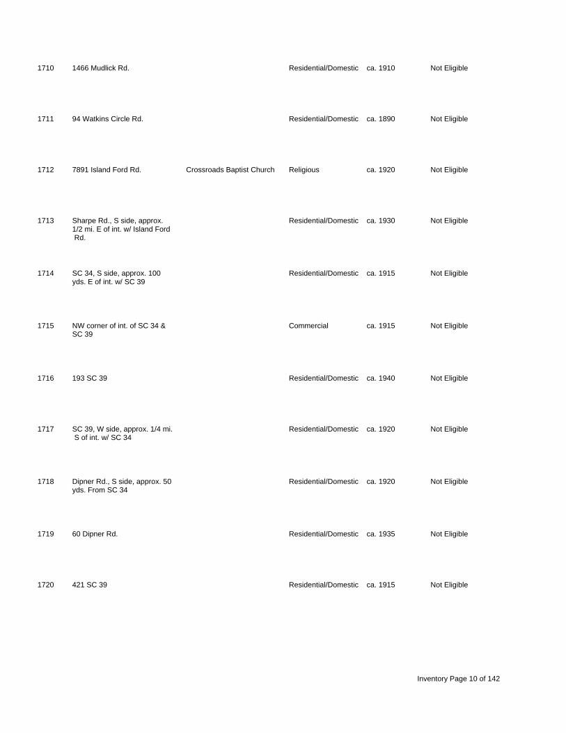
1710 1466 Mudlick Rd. Residential/Domestic ca. 1910 Not Eligible
1711 94 Watkins Circle Rd. Residential/Domestic ca. 1890 Not Eligible
1712 7891 Island Ford Rd. Crossroads Baptist Church Religious ca. 1920 Not Eligible
1713 Sharpe Rd., S side, approx. Residential/Domestic ca. 1930 Not Eligible 1/2 mi. E of int. w/ Island Ford Rd.
1714 SC 34, S side, approx. 100 Residential/Domestic ca. 1915 Not Eligible yds. E of int. w/ SC 39
1715 NW corner of int. of SC 34 & Commercial ca. 1915 Not Eligible SC 39
1716 193 SC 39 Residential/Domestic ca. 1940 Not Eligible
1717 SC 39, W side, approx. 1/4 mi. Residential/Domestic ca. 1920 Not Eligible S of int. w/ SC 34
1718 Dipner Rd., S side, approx. 50 Residential/Domestic ca. 1920 Not Eligible yds. From SC 34
1719 60 Dipner Rd. Residential/Domestic ca. 1935 Not Eligible
1720 421 SC 39 Residential/Domestic ca. 1915 Not Eligible
Inventory Page 10 of 142

1721 447 SC 39 Residential/Domestic ca. 1925 Not Eligible
1722 557 SC 39 Residential/Domestic ca. Not Eligible 1915-20
1723 621 SC 39 Residential/Domestic ca. 1925 Not Eligible
1724 200 Blackmon Rd. Unknown ca. Not Eligible 1910-20
1725 75 Blackmon Rd. Residential/Domestic ca. Not Eligible 1910-15
1726 964 SC 39 Residential/Domestic ca. 1915 Not Eligible
1727 1082 SC 39 Educational ca. 1925 Not Eligible
1728 1258 SC 39 Residential/Domestic ca. Not Eligible 1910-15
1729 1299 Long Sumpit Rd. Residential/Domestic ca. Not Eligible 1915-20
1730 SC 34, N side, approx. 100 Residential/Domestic ca. 1920 Not Eligible yds. E of int. w/ Champ Nursery Rd.
1731 SC 34, S side, approx. 1/4 mi. Residential/Domestic ca. 1925 Not Eligible E of int. w/ Cut Off Rd.
Inventory Page 11 of 142
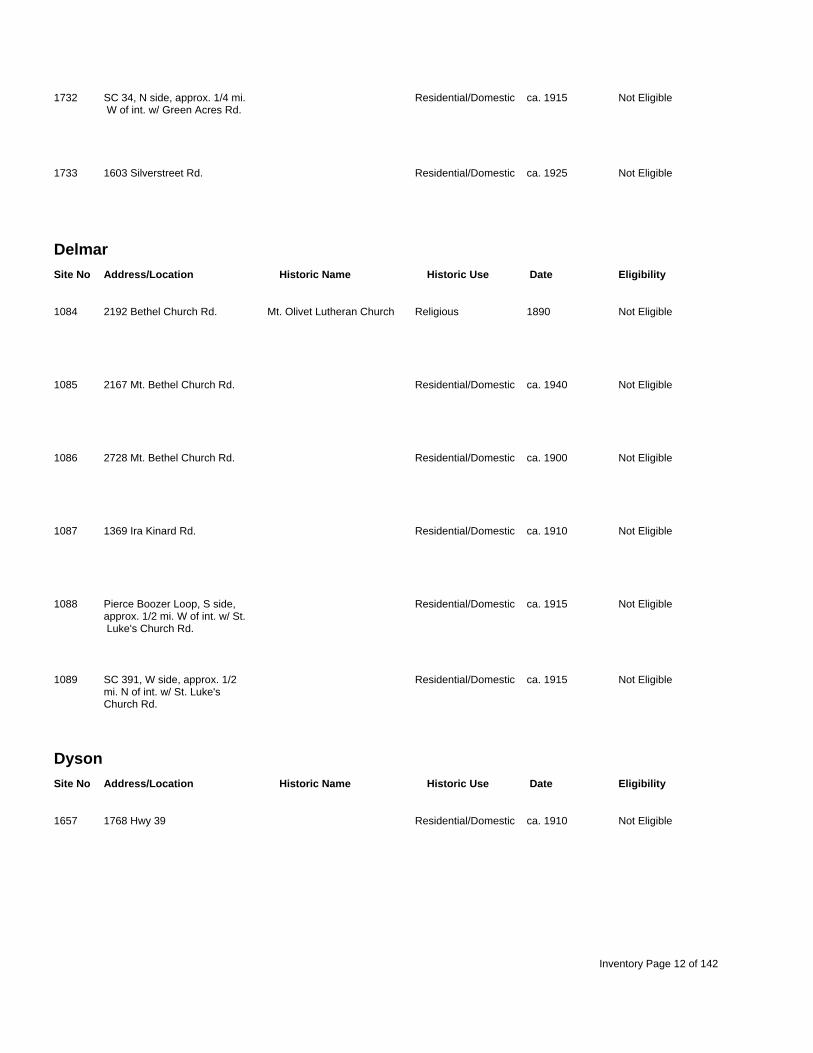
1732 SC 34, N side, approx. 1/4 mi. Residential/Domestic ca. 1915 Not Eligible W of int. w/ Green Acres Rd.
1733 1603 Silverstreet Rd. Residential/Domestic ca. 1925 Not Eligible
Delmar Site No Address/Location Historic Name Historic Use Date Eligibility
1084 2192 Bethel Church Rd. Mt. Olivet Lutheran Church Religious 1890 Not Eligible
1085 2167 Mt. Bethel Church Rd. Residential/Domestic ca. 1940 Not Eligible
1086 2728 Mt. Bethel Church Rd. Residential/Domestic ca. 1900 Not Eligible
1087 1369 Ira Kinard Rd. Residential/Domestic ca. 1910 Not Eligible
1088 Pierce Boozer Loop, S side, Residential/Domestic ca. 1915 Not Eligible approx. 1/2 mi. W of int. w/ St. Luke's Church Rd.
1089 SC 391, W side, approx. 1/2 Residential/Domestic ca. 1915 Not Eligible mi. N of int. w/ St. Luke's Church Rd.
Dyson Site No Address/Location Historic Name Historic Use Date Eligibility
1657 1768 Hwy 39 Residential/Domestic ca. 1910 Not Eligible
Inventory Page 12 of 142

1658 2183 Hwy 39 Residential/Domestic ca. 1910 Not Eligible
1659 SC 39, W side, across from Commercial ca. 1930 Not Eligible int. w/ SC 56
1660 2463 SC 39 Residential/Domestic ca. 1930 Not Eligible
1661 SC 39, E side, approx. 1/4 mi. Residential/Domestic ca. Not Eligible N of int. w/ SC 56 1890-1900
1662 SC 39, W side, approx. 1/4 mi. Residential/Domestic ca. 1915 Not Eligible S of int. w/ Poplar Springs Rd.
1663 514 Poplar Springs Rd. Residential/Domestic ca. 1900 Not Eligible
1664 Poplar Springs Rd., E side, Residential/Domestic ca. 1910 Not Eligible approx. 3/4 mi. N of int. w/ SC 39
1665 Old Cravon Place Rd., W side, Residential/Domestic ca. 1915 Not Eligible approx. 200 yds. S of int. w/ Vaughnville Church Rd.
1666 1942 SC 39 Residential/Domestic ca. 1915 Not Eligible
1668 Salters Rd., S side, appro . Educational ca. Not Eligible x 1/2 mi. W of int. w/ SC 56 1925-30
1669 SC 39, N side, approx. 100 Industrial/Engineering ca. 1910 Not Eligible yds. W of int. w/ SC 56
Inventory Page 13 of 142

Jenkinsville Site No Address/Location Historic Name Historic Use Date Eligibility
1190 605 Hope Station Rd. Unknown ca. Not Eligible 1910-20
1191 607 Hope Station Rd. St. John's Evangelical Religious 1809 Listed Lutheran Church
1192 1129 Hope Station Rd. Residential/Domestic ca. 1930 Not Eligible
1193 Hope Station Rd., W side, Hope School Educational ca. 1920 Not Eligible approx. 1/4 mi. S of int. w/ Peak Rd.
1194 243 Peak Rd. Commerical ca. Not Eligible 1920-25
1195 267 Peak Rd. Residential/Domestic ca. 1930 Not Eligible
1196 Peak Rd., S side, approx. 1/4 Residential/Domestic ca. 1910 Not Eligible mi. W of int. w/ Broad River Rd.
1197 2953 Broad River Rd. Residential/Domestic ca. 1930 Not Eligible
1198 4494 Broad River Rd. Residential/Domestic ca. Not Eligible 1925-30
1199 145 Magnolia Ln. Residential/Domestic ca. 1915 Not Eligible
Inventory Page 14 of 142

1200 1766 Broad River Rd. Residential/Domestic ca. 1900 Not Eligible
1201 1405 Broad River Rd. Residential/Domestic ca. 1940 Not Eligible
Joanna Site No Address/Location Historic Name Historic Use Date Eligibility
1636 28855 Hwy 76 Commercial ca. 1940 Not Eligible
1637 SE corner of Carlisle Oxner Commercial ca. 1910 Not Eligible Rd. & SC 560
1638 100 Carlisle Oxner Rd. Sharon Methodist Church Religious ca. 1905 Not Eligible
1639 306 Carlisle Oxner Rd. Residential/Domestic ca. 1920 Not Eligible
1640 29485 Hwy 76 Commercial ca. 1920 Not Eligible
1641 County Line Rd., E side, Residential/Domestic ca. Not Eligible approx. 1/4 mi. N of int. w/ 1915-20 Hwy 76
1642 Hwy 76, N side, approx. 1/4 Educational cal. 1920 Not Eligible mi. E of int. w/ SC 560
1643 Hwy 76, N side, approx. 1/4 Residential/Domestic ca. 1925 Not Eligible mi. E of int. w/ SC 560
Inventory Page 15 of 142

1644 Hwy 76, N side, appro . 1/2 Unknown ca. Not Eligible x mi. E of int. w/ SC 560 1910-15
Lake Murray West Site No Address/Location Historic Name Historic Use Date Eligibility
1076 1560 Holland's Lodge Rd. Residential/Domestic ca. 1930 Not Eligible
1077 100 yds. W of 489 Holland's Residential/Domestic ca. 1910 Not Eligible Lodge Rd.
1078 2484 Macedonia Church Rd. Residential/Domestic ca. 1910 Not Eligible
1079 2270 Macedonia Church Rd. Residential/Domestic ca. 1880 Not Eligible
1080 SE corner of int. of Macedonia Educational ca. 1920 Not Eligible Church Rd. and Bob Fulmer Rd.
1081 49 Macedonia Church Rd. Macedonia Lutheran Church Religious 1914 Not Eligible
1082 Granny Hill Rd., N side, Residential/Domestic ca. 1890 Not Eligible approx. 1/2 mi. E of int. w/ Holland's Lodge Rd.
1083 610 Holly Pt. Rd. Residential/Domestic ca. 1890 Not Eligible
Little Mountain Site No Address/Location Historic Name Historic Use Date Eligibility
Inventory Page 16 of 142

1090 567 Four Oaks Rd. Residential/Domestic ca. 1850 Not Eligible
1091 Parr Rd., W side, approx. 1/4 Residential/Domestic ca. 1910 Not Eligible mi. N of int. w/ Four Oaks Rd.
1092 1719 Parr Rd. Residential/Domestic ca. 1910 Not Eligible
1093 1847 Parr Rd. Residential/Domestic ca. 1880 Not Eligible
1094 2117 Parr Rd. Residential/Domestic ca. Not Eligible 1890-1900
1095 Chapman Rd., E side, approx. Residential/Domestic ca. 1915 Not Eligible 1/4 mi. S of int. w/ Parr Rd.
1096 831Chapman Rd. Chapman House Residential/Domestic ca. 1900 Not Eligible
1106 256 Windsong Tr. Residential/Domestic ca. 1915 Not Eligible
1107 1093 Nursery Rd. Residential/Domestic ca. 1930 Not Eligible
1108 1061 Nursery Rd. Residential/Domestic ca. 1930 Not Eligible
1109 Mill Rd., E side, approx. 100 Residential/Domestic ca. 1910 Not Eligible yds. S of int. w/ Ponderosa Ln.
Inventory Page 17 of 142

1110 Wheeland Rd., E side, approx. Residential/Domestic ca. 1870 Not Eligible 1/4 mi. S of int. w/ Mill Rd.
1111 261 Wheeland School Rd. Residential/Domestic ca. 1920 Not Eligible
1112 2601 Wheeland Rd. Fike-Sease-Fulmer House Residential/Domestic ca. 1900 Eligible
1113 171A Mill Rd. Residential/Domestic ca. 1880 Not Eligible
1114 1128 Wheeland School Rd. Religious ca. 1880 Not Eligible
1115 20 Loop Rd. Residential/Domestic ca. Not Eligible 1910-15
1116 137 Wheeland Rd. Residential/Domestic ca. 1920 Not Eligible
1117 Seibert Rd., N side, approx. 1 Residential/Domestic ca. 1910 Not Eligible mi. W of int. w/ Macedonia Church Rd.
1118 Wheeland Rd., S side, approx. Residential/Domestic ca. 1920 Not Eligible 1 mi. E of int. w/ Macedonia Church Rd.
1119 1455 Wheeland Rd. Residential/Domestic ca. 1890 Not Eligible
1120 Macedonia Church Rd., E side, Educational ca. 1920 Not Eligible approx. 100 yds. S of int. w/ Stockman Rd.
Inventory Page 18 of 142

1121 1622 Wheeland School Rd. Residential/Domestic ca. 1920 Not Eligible
1122 1189 Wheeland School Rd. Residential/Domestic ca. 1900 Not Eligible
1123 4301 Wheeland Rd. Residential/Domestic ca. 1915 Not Eligible
1124 5303 Wheeland Rd. Residential/Domestic ca. 1920 Not Eligible
1125 5597 Wheeland Rd. Residential/Domestic ca. 1910 Not Eligible
1126 2092 Hwy 76 Residential/Domestic ca. 1920 Not Eligible
1127 2240 Hwy 76 Residential/Domestic ca. 1925 Not Eligible
1128 1974 Hwy 76 Residential/Domestic ca. Not Eligible 1915-20
1129 Holy Trinity Church Rd., S Residential/Domestic ca. 1920 Not Eligible side, across from int. w/ Parr Rd.
1130 249 Parr Rd. Residential/Domestic ca. 1910 Not Eligible
1131 Parr Rd., E side, approx, 3/4 Residential/Domestic ca. 1910 Not Eligible mi. N of int. w/ Holy Trinity Church Rd.
Inventory Page 19 of 142

1132 2009 Holy Trinity Church Rd. Residential/Domestic ca. 1915 Not Eligible
1133 1703 Holy Trinity Church Rd. Residential/Domestic ca. 1915 Not Eligible
1134 263 Harris Rd. Residential/Domestic ca. 1920 Not Eligible
1135 55 Sam's Circle Residential/Domestic ca. 1880 Not Eligible
1136 Central School Rd., W side, Residential/Domestic ca. 1915 Not Eligible approx. 100 yds. S of int. w/ Koon's Trestle Rd.
1137 347 Central School Rd. Residential/Domestic ca. 1925 Not Eligible
1138 917 Koon's Trestle Rd. Residential/Domestic ca. 1910 Not Eligible
1139 2491 SC 773 St. Paul's Lutheran Church Religious 1936 Eligible
1140 2745 SC 773 Residential/Domestic ca. 1915 Not Eligible
1141 3064 SC 773 Residential/Domestic ca. 1915 Not Eligible
1142 Wicker Rd., S side, approx. Residential/Domestic ca. 1925 Not Eligible 1/8 mi. W of int. w/ SC 773
Inventory Page 20 of 142

1143 Wicker Rd., N side, approx. Residential/Domestic ca. 1910 Not Eligible 1/2 mi. W of int. w/ SC 773
1144 1098 Wicker Rd. Residential/Domestic ca. 1920 Not Eligible
1145 931 Wicker Rd. Residential/Domestic ca. 1925 Not Eligible
1149 1865 Old Jollystreet Rd. Residential/Domestic ca. 1920 Not Eligible
1150 1743 Old Jollystreet Rd. Residential/Domestic ca. 1925 Not Eligible
1151 1619 Old Jollystreet Rd. Residential/Domestic ca. 1900 Not Eligible
1152 Old Jollystreet Rd., W side, Residential/Domestic ca. 1880 Not Eligible approx. 1 mi. N of int. w/ Hwy 76
1153 998 Old Jollystreet Rd. Residential/Domestic ca. 1905 Not Eligible
1154 530 Old Jollystreet Rd. Residential/Domestic ca. 1910 Not Eligible
1155 SC 773, W side, approx. 3/4 Residential/Domestic ca. 1890 Not Eligible mi. S of int. w/ I-26
1156 Kibler's Bridge Rd., N side, Residential/Domestic ca. 1870 Not Eligible approx. 1/2 mi. E of int. w/ SC 773
Inventory Page 21 of 142

1157 3120 Kibler's Bridge Rd. Residential/Domestic ca. 1850 Not Eligible
1158 2734 Kibler's Bridge Rd. Residential/Domestic ca. 1850 Not Eligible
1159 357 Dr. Bowers Rd. Residential/Domestic ca. 1920 Not Eligible
1160 193 Caldwell Dr. Residential/Domestic ca. 1920 Not Eligible
1161 447 Caldwell Dr. Residential/Domestic ca. 1900 Not Eligible
1162 1637 Kibler's Bridge Rd. Residential/Domestic ca. 1920 Not Eligible
1163 520 Kibler's Bridge Rd. Residential/Domestic ca. 1915 Not Eligible
1164 646 Burley Boland Rd. Residential/Domestic ca. 1920 Not Eligible
1165 752 SC 202 Residential/Domestic ca. 1915 Not Eligible
1166 1097 SC 202 Residential/Domestic ca. 1840 Not Eligible
1167 522 Mt. Tabor Rd. Residential/Domestic ca. 1925 Not Eligible
Inventory Page 22 of 142

1168 SE corner of int. of Mt. Tabor Mt. Tabor Lutheran Church Religious 1925 Not Eligible Rd. and Dr. Bowers Rd.
1169 2528 Old Dutch Rd. Residential/Domestic ca. Not Eligible 1920-25
1170 1828 Old Dutch Rd. Residential/Domestic ca. 1930 Not Eligible
1171 580 Coley Todd Rd. Residential/Domestic ca. 1930 Not Eligible
1172 Pa Metts Rd., S side, approx. Residential/Domestic ca. 1920 Not Eligible 1/4 mi. W of int. w/ Old Dutch Rd.
1173 1450 Pugh Rd. Residential/Domestic ca. 1915 Not Eligible
1174 973 Long Rd. Residential/Domestic ca. 1900 Not Eligible
1175 2336 Mt. Pilgrim Church Rd. Mt. Pilgrim Lutheran Church Religious 1934 Not Eligible
1176 Mt. Pilgrim Church Rd., E side, Educational ca. Not Eligible approx. 1/4 mi. S of int. w/ 1920-25 Hwy 76
1177 1563 Whippoorwill Rd. Residential/Domestic ca. 1880 Not Eligible
1178 Whippoorwill Rd., N side, Residential/Domestic ca. 1870, Eligible approx. 300 yds. W of int. w/ 1910 Hwy 76
Inventory Page 23 of 142

1179 5138 Hwy 76 Residential/Domestic ca. 1915 Not Eligible
1180 Dowd Rd., E side, approx. 200 Residential/Domestic ca. 1910 Not Eligible yds. S of int. w/ Hwy 76
1181 5320 Hwy 76 Residential/Domestic ca. 1915 Not Eligible
1182 SE corner of int. of Hwy 76 & Residential/Domestic ca. 1930 Not Eligible Mt. Pilgrim Church Rd.
1183 Hwy 76, N side, approx. 3/4 Residential/Domestic ca. 1900 Not Eligible mi. E of int. w/ SC 773
1184 Hwy 76, S side, approx. 1/4 Residential/Domestic ca. 1925 Not Eligible mi. E of int. w/ Cy Shumpert Rd.
1185 1918 Cy Shumpert Rd. Residential/Domestic ca. 1920 Not Eligible
1186 Cy Shumpert Rd., W side, Residential/Domestic ca. 1925 Not Eligible approx. 1/2 mi. S of int. w/ Hwy 76
1187 Lovelace Cir., E side, approx. Residential/Domestic ca. 1890 Not Eligible 1/4 mi. S of int. w/ Cy Shumpert Rd.
1188 518 Lovelace Circle Residential/Domestic ca. 1900 Not Eligible
1189 Lovelace Circle, S side, Residential/Domestic ca. 1910 Not Eligible approx. 100 yds. E of int. w/ Cy Shumpert Rd.
Inventory Page 24 of 142

Newberry East Site No Address/Location Historic Name Historic Use Date Eligibility
0325 1209 Caldwell St. Old Court House Government/Public 1853 Listed
0326 1201 McKibben St. City Hall/Opera House Government/Public 1881 Listed
0327 1227 McKibben St. Newberry Fire Department Other ca. 1936 Contributes to Listed District
0328 1200 Nance St. Memorial Park recreation 1789 Contributes to Listed , 1928 District
0329 1200 McKibben St. The Square ( of Old Civic/Social 1853 Contributes to Listed rear Court House) District
0330 1119 Boyce St. The Commercial Bank Commercial ca. 1923 Contributes to Listed District
0331 1117 Boyce St. The State Building Commercial 1853 Contributes to Listed District
0332 1107 Boyce St. Commercial ca. 1855 Contributes to Listed District
0333 1101 Boyce St. Nat Gist Building Commercial Contributes to Listed District
0334 1108-1110 Harrington St. Commercial Contributes to Listed District
Inventory Page 25 of 142

0335 1215 Main St. Commercial Contributes to Listed District
0336 1213 Main St. Commercial ca. 1880 Contributes to Listed District
0337 1211 Main St. Commercial ca. 1880 Contributes to Listed District
0338 1209 Main St. Garner's Shoes Commercial ca. 1880 Contributes to Listed District
0339 1207 Main St. Old Central Drug Company Commercial ca. 1879 Contributes to Listed District
0340 1202 Caldwell St. Mollohon Row Commercial 1879 Contributes to Listed District
0341 1204 Caldwell St. Mollohon Row (Clary's) Commercial 1879 Contributes to Listed District
0342 1206 Caldwell St. Mollohon Row Commercial 1879 Contributes to Listed District
0343 1201 Boyce St. McCaughrin Block Commercial ca. 1890 Contributes to Listed District
0344 1219 Boyce St. Commercial ca. 1886 Contributes to Listed District
0345 1215 Boyce St. Commercial ca. 1890 Contributes to Listed District
Inventory Page 26 of 142

0346 1207 Boyce St. C.T. Summer Hardware Commercial Contributes to Listed District
0347 1311 Main St. Commercial Contributes to Listed District
0348 1309 Main St. Commercial 1907 Contributes to Listed District
0349 1307 Main St. Commercial 1907 Contributes to Listed District
0350 1303 Main St. Exchange Bank Building Commercial 1918 Contributes to Listed District
0351 1226 College St. County Court House Commercial 1907-8 Contributes to Listed District
0352 1516 Martin St. Residential/Domestic ca. 1935 Contributes to Listed District
0353 1511 Main St. Ritz Theatre Entertainment/Recre 1936 Contributes to Eligible District
0354 1507 Main St. Wimpy's Hamburger Stand Commercial ca. 1940 Contributes to Eligible District
0355 1505 Main St. Commercial ca. 1925 Contributes to Eligible District
0356 1501 Main St. Lominack Drugs Commercial ca. 1925 Contributes to Eligible District
Inventory Page 27 of 142

0357 1413 Main St. Commercial ca. 1925 Contributes to Eligible District
0358 1411 Main St. Commercial ca. 1925 Contributes to Eligible District
0359 1409 Main St. Commercial ca. 1925 Contributes to Eligible District
0360 1407 Main St. Commercial ca. 1925 Contributes to Eligible District
0361 1405 Main St. Commercial ca. 1920 Contributes to Eligible District
0362 1403 Main St. Commercial ca. 1920 Contributes to Eligible District
0363 1401 Main St. Commercial ca. 1907 Contributes to Eligible District
0364 1214 Lindsay St. Commercial ca. 1940 Not Eligible
0365 1320 Lindsay St. Mule Barn Commercial ca. 1910 Not Eligible
0366 1512 Martin St. Newberry Agricultural Agricultural ca. 1950 Not Eligible Building
0367 1529 Main St. Goodyear, Little Star Food Commercial ca. 1940 Not Eligible Store, Colonial Grocery
Inventory Page 28 of 142

0368 1524 Martin St. Residential/Domestic ca. 1940 Not Eligible
0369 1546 Martin St. Residential/Domestic ca. 1940 Not Eligible
0370 1211 Calhoun St. Aveleigh Presbyterian Religious ca. 1930 Contributes to Listed Church District
0371 1207 Calhoun St. Residential/Domestic ca. 1940 Not Eligible
0372 1607 Main St. St. Luke's Episcopal Religious ca. 1855, Contributes to Listed Church 1985 District
0373 1605 Main St. St. Luke's Parish House Residential/Domestic ca. 1905 Contributes to Listed District
0374 1531 Main St. Martin House Residential/Domestic ca. 1835, Contributes to Listed 1890 District
0375 1018 Main St. Commercial ca. 1850 Contributes to Listed District
0376 1016 Main St. Commercial ca. 1850 Contributes to Listed District
0377 1014 Main St. Commercial ca. 1910 Contributes to Listed District
0378 1010-1012 Main St. Commercial ca. 1910 Contributes to Listed District
Inventory Page 29 of 142

0379 1008 Main St. Commercial ca. 1910 Contributes to Listed District
0380 1006 Main St. Commercial ca. Contributes to Listed District
0381 1116-1118 Main St. Summer Brothers / Commercial ca. 1880 Listed McCrory's / Lane Building
0382 1110-1114 Main St. Old Roses Store/Lane Commercial ca. 1880, Contributes to Listed Building 1936 District
0383 1100 Main St. Southland Suit Co. Commercial ca. 1910 Contributes to Listed District
0384 1104 McKibben St. Commercial ca. 1950 Not Eligible
0385 1105 Friend St. Commercial ca. 1910 Not Eligible
0386 1107 Friend St. Commercial ca. 1910 Not Eligible
0387 1109 Friend St. Commercial ca. 1910 Not Eligible
0388 1101-1103 Caldwell St. Newberry Post Office Commercial ca. 1880 Contributes to Listed District
0389 1109 Caldwell St. Commercial ca. 1930 Contributes to Listed District
Inventory Page 30 of 142

0390 1216 Main St. Carpente 's (Mower Commercial ca. 1870 Contributes to Listed r Building) District
0391 1214 Main St. Clary's, Proctor Todd's Commercial ca. 1870 Contributes to Listed Store District
0392 1212 Main St. Pelham Pharmacy, Main Commercial ca. 1870 Contributes to Listed St. Pharmacy District
0393 1200 Main St. Newberry Hotel Commercial 1879-1880 Contributes to Listed District
0394 1104 Caldwell St. Commercial ca. 1908 Contributes to Listed District
0395 1100 Caldwell St. Tom Cromer's Shoe Repair Commercial ca. 1950 Not Eligible
0396 Friend St. Commercial ca. 1890 Not Eligible
0397 Friend St. Addition to Old Hotel Commercial ca. 1930 Contributes to Listed District
0398 1318 Main St. Belk Commercial ca. 1912 non-contributing in listed district
0399 1312 Main St. The Fashion Commercial ca. Contributes to Eligible 1927-1935 District
0400 1310 Main St. Southern Auto Commercial ca. 1915 Contributes to Eligible District
Inventory Page 31 of 142

0401 1308 Main St. Wig Villa, Diana Commercial ca. 1908 noncontributing in listed district
0402 1304 Main St. Commercial ca. 1908 Contributes to Eligible District
0403 1300 Main St. Commercial ca. 1908 noncontributing in listed district
0404 1400 Main St. Commercial ca. 1915 Contributes to Eligible District
0405 1402 Main Street Commercial ca. 1915 Contributes to Eligible District
0406 1406-1410 Main St. B.C. Moore's/Smith Motor Commercial ca. 1920 Contributes to Eligible Company District
0408 1412 Main St. Commercial ca. 1925 Contributes to Eligible District
0409 1414 Main St. Commercial ca. 1925 Contributes to Eligible District
0410 1418 Main St. Commercial ca. 1920 Contributes to Eligible District
0411 1109 Wilson St. Dr. Anderson's Office Commercial ca. 1940 Contributes to Eligible District
0412 1500 Main St. Friday Motor Company Commercial ca. 1915 Contributes to Eligible District
Inventory Page 32 of 142

0413 1504 Main St. Jones Florist, Hayes Motor Commercial ca. Contributes to Eligible Company 1915-20 District
0414 1506 Main St. Altman Building (Hill Bros. Commercial ca. 1925 Contributes to Eligible Storage, Altman Appliance) District
0415 1512 Main St. Johnny's News Stand Commercial ca. 1925 Contributes to Eligible District
0416 1530 Main St. Smith Motor Company Commercial ca. 1920 Contributes to Eligible District
0417 1600 Main Street O.L. Schumpert House Residential/Domestic ca. 1908 Contributes to Listed District
0418 1604 Main St Buzhardt-Rook House Residential/Domestic ca. 1935 Contributes to Listed District
0419 1608 Main St. Residential/Domestic ca. 1910 Contributes to Listed District
0420 1103 Calhoun St. Floyd-Carpenter House Residential/Domestic ca. 1902 Contributes to Listed District
0421 1604 Friend St. Floyd-Carpenter House Residential/Domestic ca. 1930 Contributes to Listed servant's quarters District
0422 1603 Johnstone St. Residential/Domestic ca. 1910 Not Eligible
0423 1016 Friend St. Commercial ca. 1940 Not Eligible
Inventory Page 33 of 142

0424 McKibben St. Commercial ca. 1950 Not Eligible
0425 1005 College St. Central Methodist Church Religious 1900-1901 Contributes to Listed District
0426 1000 College St. Residential/Domestic ca. 1850 Not Eligible
0427 1300 Friend St. Old Post Office Government/Public 1911 Contributes to Listed District
0428 1304 Friend St. City Filling Station Commercial ca. 1935 Not Eligible
0429 1410 Friend St. Leslie House Residential/Domestic ca. 1908 Not Eligible
0430 1004 Wilson St. Leslie House Residential/Domestic ca. 1920 Not Eligible
0431 1523 Johnstone St. Anderson House Residential/Domestic ca. 1880 Not Eligible
0432 1517 Johnstone St. E.S. Summer House Residential/Domestic ca. 1900 Not Eligible
0433 1505 Johnstone St. Residential/Domestic ca. Not Eligible 1925-30
0434 1003 Wilson St. Stewart, Thomas House Residential/Domestic ca. 1910 Not Eligible
Inventory Page 34 of 142

0435 1005 Wilson St. Residential/Domestic ca. 1910 Not Eligible
0436 1518 Friend St. Residential/Domestic ca. 1908 Not Eligible
0437 1520 Friend St. Residential/Domestic ca. 1925 Not Eligible
0438 1524 Friend St. Residential/Domestic ca. 1950 Not Eligible
0439 1530 Friend St. Residential/Domestic ca. 1910 Not Eligible
0440 1015 Boundary St. Residential/Domestic Not Eligible
0441 909 College St. Newberry Female Educational/residenti ca. 1855 Not Eligible Academy/Houseal Clinic
0442 904 Caldwell St. Residential/Domestic ca. 1910 Not Eligible
0443 902 Caldwell St. Residential/Domestic ca. 1910 Not Eligible
0444 1407 Boundary St. Cannon House Residential/Domestic ca. 1920 Not Eligible
0445 909 Wilson St. Residential/Domestic ca. 1920 Not Eligible
Inventory Page 35 of 142

0446 1400 Johnstone St. Residential/Domestic ca. 1950 Not Eligible
0447 1401 Boundary St. Residential/Domestic ca. 1910 Not Eligible
0448 1527 Boundary St. Residential/Domestic ca. 1945 Not Eligible
0449 1523 Boundary St. Residential/Domestic ca. 1910 Not Eligible
0450 corner of Boundary, Wilson & Religious ca. 1955, Not Eligible Johnstone Sts. 1964
0451 1524 Johnstone St. Paysinger House Residential/Domestic ca. 1940 Not Eligible
0452 1604 Johnstone St. Halfacre House Residential/Domestic ca. 1945 Not Eligible
0453 1606 Johnstone St. Residential/Domestic ca. 1945 Not Eligible
0454 2007 College St. Dr. Kinard House Residential/Domestic ca. 1948 Not Eligible
0455 2005 College St. Residential/Domestic ca. 1930 Not Eligible
0456 1211 Chapman St. Residential/Domestic ca. 1945 Not Eligible
Inventory Page 36 of 142

0457 1207 Chapman St. Residential/Domestic ca. 1940 Not Eligible
0458 1201 Chapman St. Residential/Domestic ca. 1930 Not Eligible
0459 1199 Chapman St. Residential/Domestic ca. 1930 Not Eligible
0460 1197 Chapman St. Residential/Domestic ca. 1930 Not Eligible
0461 1193 Chapman St. Residential/Domestic ca. 1930 Not Eligible
0465 1910 Nance St. Cannon House Residential/Domestic ca. 1946 Not Eligible
0466 1609-1613 Pope Terrace, 1109 Youth Center, Girl Scouts, Civic/Social ca. 1935 Not Eligible Speers St. Boy Scouts
0467 1700 Nance St. Residential/Domestic ca. 1900 Not Eligible
0468 1704 Nance St. Residential/Domestic ca. 1910 Not Eligible
0469 1708 Nance St. Residential/Domestic ca. 1930 Not Eligible
0470 1806 Nance St. Long House Residential/Domestic ca. 1920 Not Eligible
Inventory Page 37 of 142

0473 1124 Chapman St. Margaret Hunter Park Landscape ca. 1940 Contributes to Listed District
0474 1817 College St. Ernest Martin House Residential/Domestic ca. 1905 Contributes to Listed District
0476 1807 College St. Residential/Domestic ca. 1910 Contributes to Listed District
0477 1801 College St. Spearman House Residential/Domestic ca. 1906 Contributes to Listed District
0478 1220 Chapman St. Residential/Domestic ca. 1950 Not Eligible
0479 1703 College St. Rutherford Residential/Domestic 1904 Contributes to Listed House/Johnstone-Rutherfor District d House
0480 1707-1709 College St. Residential/Domestic ca. 1935 Contributes to Listed District
0481 1717 College St. Residential/Domestic ca. 1935 Contributes to Listed District
0482 1719 College St. Residential/Domestic ca. 1935 Contributes to Listed District
0483 1710 Kibler St. Residential/Domestic ca. 1935 Contributes to Listed District
0484 1112 Speers St. Residential/Domestic ca. 1950 Not Eligible
Inventory Page 38 of 142

0485 1531 Caldwell St. Residential/Domestic ca. 1910 Not Eligible
0486 1527 Caldwell St. Residential/Domestic ca. 1925 Not Eligible
0487 1525 Caldwell St. Residential/Domestic ca. 1925 Not Eligible
0488 1523 Caldwell St. Residential/Domestic ca. 1910 Not Eligible
0489 1519 Caldwell St. Residential/Domestic ca. 1920 Not Eligible
0490 1515 Caldwell St. Residential/Domestic ca. 1910 Not Eligible
0491 1509 Caldwell St. Residential/Domestic ca. 1920 Not Eligible
0492 1505 Caldwell St. Residential/Domestic ca. 1920 Not Eligible
0493 1501 Caldwell St. Residential/Domestic ca. 1920 Not Eligible
0494 1113 Purcell St. Residential/Domestic ca. 1920 Not Eligible
0495 1109 Purcell St. Residential/Domestic ca. 1915 Not Eligible
Inventory Page 39 of 142

0496 1103 Purcell St. Residential/Domestic ca. 1920 Not Eligible
0497 1502 Nance St. Residential/Domestic ca. 1930 Not Eligible
0498 1504 Nance St. Residential/Domestic ca. 1925 Not Eligible
0499 1506 Nance St. Residential/Domestic ca. 1930 Not Eligible
0500 1508 Nance St. Residential/Domestic ca. 1930 Not Eligible
0501 1600 Nance St. Residential/Domestic ca. 1940 Not Eligible
0502 1114 Purcell St. Residential/Domestic ca. 1900 Not Eligible
0503 1608 Nance St. Residential/Domestic ca. 1945 Not Eligible
0504 1110 Speers St. Residential/Domestic ca. 1950 Not Eligible
0505 1110 Purcell St. Residential/Domestic ca. 1930 Not Eligible
0506 1106 Purcell St. Residential/Domestic ca. 1920 Not Eligible
Inventory Page 40 of 142

0507 1102 Purcell St. Residential/Domestic ca. 1900 Not Eligible
0508 1405 Caldwell St. Old Cotton Warehouse Agricultural ca. 1900 Not Eligible
0509 1109 Harrington St. The Market Basket Commercial ca. 1955 Not Eligible
0510 1119 Harrington St. Old Animal Hospital Health Care ca. 1925 Not Eligible
0511 1315 Caldwell St. Commercial ca. 1955 Not Eligible
0512 1327 Caldwell St P.D. Johnson & Co./ Ruff Commercial ca. 1950 Not Eligible Tractor Co.
0513 1530 Caldwell St. Blalock House Residential/Domestic ca. 1900 Not Eligible
0514 1526 Caldwell St. Residential/Domestic ca. 1935 Not Eligible
0515 1524 Caldwell St. Residential/Domestic ca. 1930 Not Eligible
0516 1510 Caldwell St. Residential/Domestic ca. 1920 Not Eligible
0517 1508 Caldwell St. Residential/Domestic ca. 1930 Not Eligible
Inventory Page 41 of 142

0518 1506 Caldwell St. Residential/Domestic ca. 1930 Not Eligible
0519 1502 Caldwell St. Residential/Domestic ca. 1930 Not Eligible
0520 1201 Tench St. Commercial ca. 1950 Not Eligible
0521 College St. Bethlehem Baptist Church Religious ca. 1901 Contributes to Listed District
0522 1507 College St. Cromer House Residential/Domestic ca. 1950 Contributes to Listed District
0523 1509 College St. Setzler House Residential/Domestic ca. 1930 Contributes to Listed District
0524 1609 College St. Hentz House Residential/Domestic ca. 1930 Contributes to Listed District
0525 1611 College St. Eargle House Residential/Domestic ca. 1910 Contributes to Listed District
0526 1615 College St. Smith House Residential/Domestic ca. 1920 Contributes to Listed District
0527 1621 College St. Davis House Residential/Domestic ca. 1905 Contributes to Listed District
0528 1208 Spears St. Residential/Domestic ca. 1950 Not Eligible
Inventory Page 42 of 142
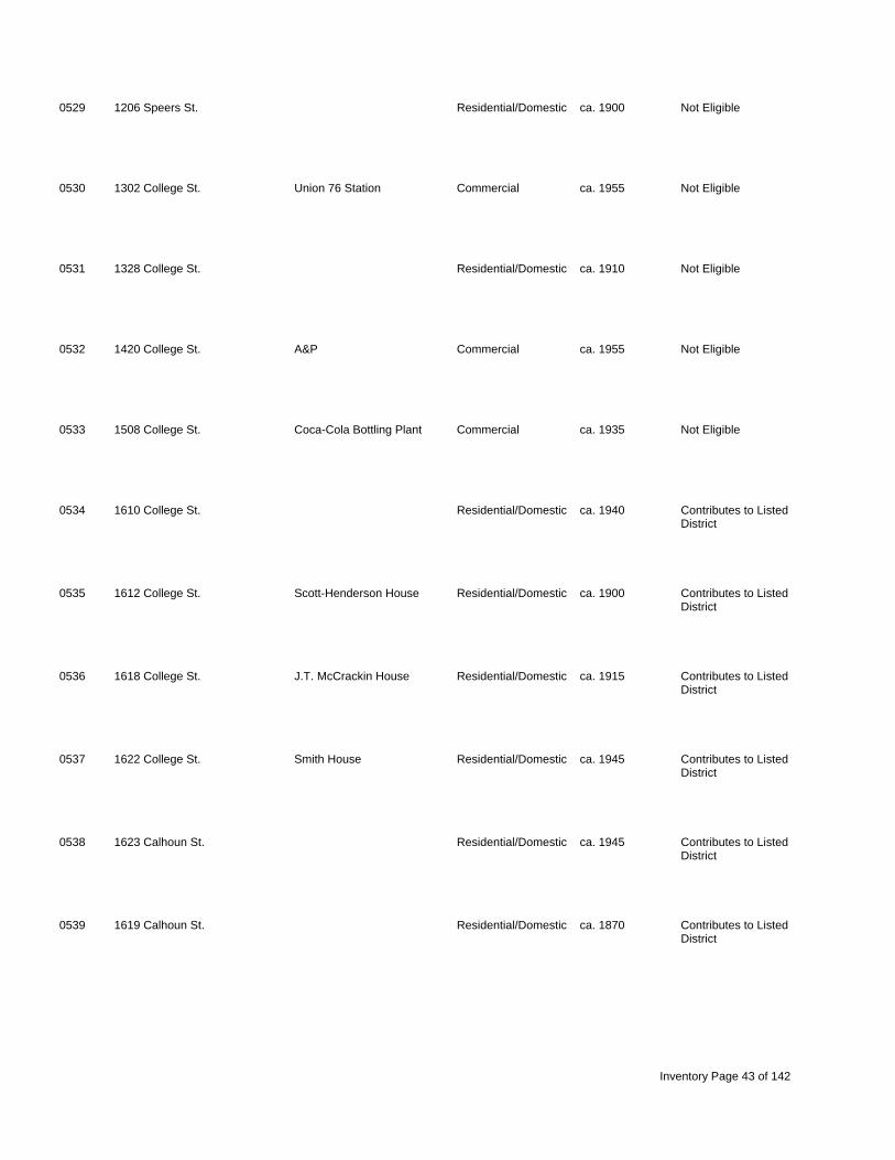
0529 1206 Speers St. Residential/Domestic ca. 1900 Not Eligible
0530 1302 College St. Union 76 Station Commercial ca. 1955 Not Eligible
0531 1328 College St. Residential/Domestic ca. 1910 Not Eligible
0532 1420 College St. A&P Commercial ca. 1955 Not Eligible
0533 1508 College St. Coca-Cola Bottling Plant Commercial ca. 1935 Not Eligible
0534 1610 College St. Residential/Domestic ca. 1940 Contributes to Listed District
0535 1612 College St. Scott-Henderson House Residential/Domestic ca. 1900 Contributes to Listed District
0536 1618 College St. J.T. McCrackin House Residential/Domestic ca. 1915 Contributes to Listed District
0537 1622 College St. Smith House Residential/Domestic ca. 1945 Contributes to Listed District
0538 1623 Calhoun St. Residential/Domestic ca. 1945 Contributes to Listed District
0539 1619 Calhoun St. Residential/Domestic ca. 1870 Contributes to Listed District
Inventory Page 43 of 142

0540 1611 Calhoun St. Residential/Domestic ca. 1930 Not Eligible
0541 1603 Calhoun St. Residential/Domestic ca. 1905 Not Eligible
0548 936 Cornelia St. Residential/Domestic ca. 1910 Not Eligible
0549 940 Cornelia St. Residential/Domestic ca. 1935 Not Eligible
0550 1503 Nance St. Water & Lights Garage Industrial/Engineering ca. 1930 Not Eligible
0551 1503 Nance St. E.S. Coppock House Residential/Domestic ca. 1825, Eligible 1855
0552 1503 Nance St. Gauntt-Dominick House Residential/Domestic ca. 1808 Not Eligible
0553 corner of Na ce and Power Industrial/Engineering ca. 1915, Not Eligible n House Rds. 1932
0554 1402 Harris St. Residential/Domestic ca. 1920 Not Eligible
0555 1404 Harris St. Residential/Domestic ca. 1920 Not Eligible
0562 917 Harrington St. Commercial ca. 1945 Not Eligible
Inventory Page 44 of 142

0563 903 Harrington St. Commercial ca. 1950 Not Eligible
0564 1321 McKibben St. Residential/Domestic ca. 1935 Not Eligible
0565 College St. Government/Public ca. 1950 Not Eligible
0566 Lindsay St. Wells Japanese Gardens Entertainment/Recre ca. 1930 Listed
0567 1519 Harrington St. Residential/Domestic ca. 1900 Not Eligible
0568 1525 Harrington St. Residential/Domestic ca. 1910 Not Eligible
0569 1529 Harrington St. Residential/Domestic ca. 1915 Not Eligible
0570 1537 Harrington St. Wells House Residential/Domestic ca. 1920 Not Eligible
0571 1603 Harrington St. Martin House Residential/Domestic ca. 1870 Not Eligible
0572 1617 Harrington St. Residential/Domestic ca. 1890 Not Eligible
0573 1621 Harrington St. Residential/Domestic ca. 1900 Not Eligible
Inventory Page 45 of 142

0574 1623 Harrington St. Residential/Domestic ca. 1900 Not Eligible
0575 1531 Calhoun St. Residential/Domestic ca. 1940 Not Eligible
0576 1508 Lindsay St. Residential/Domestic ca. 1930 Not Eligible
0577 1401 Martin St. Bubba's Commercial ca. 1950 Not Eligible
0578 1510 Harrington St. Residential/Domestic ca. 1900 Not Eligible
0579 1514 Harrington St. Residential/Domestic ca. 1900 Not Eligible
0580 1518 Harrington St. Residential/Domestic ca. 1920 Not Eligible
0581 1577 Martin St. Commercial ca. 1950 Not Eligible
0582 1601 Martin St. Residential/Domestic ca. 1940 Not Eligible
0583 1225 Calhoun St. Hunt, Isaac House Residential/Domestic ca. 1908 Contributes to Listed District
0584 1229 Calhoun St. Boozer, Samuel P. House Residential/Domestic ca. 1860 Contributes to Listed District
Inventory Page 46 of 142

0585 1233 Calhoun St. Smith, William House Residential/Domestic ca. 1880 Contributes to Listed District
0586 1235 Calhoun St. Residential/Domestic ca. 1950 Not Eligible
0587 1606 Harrington St. Residential/Domestic ca. 1900 Not Eligible
0588 1600 Harrington St. Rodelsperger House/Brown, Residential/Domestic ca. 1910 Not Eligible Alex House
0634 1711 Nance St. Residential/Domestic ca. 1870 Not Eligible
0635 1703 Nance St. Swittenburg House Residential/Domestic ca. 1940 Not Eligible
0636 949 Speers St. Chero-Cola Bottling Plant Industrial/Engineering ca. 1935 Not Eligible
0637 939 Speers St. Residential/Domestic ca. 1870 Not Eligible
0638 950 Speers St. Residential/Domestic ca. 1940 Not Eligible
0639 1613 Nance St. Residential/Domestic ca. 1950 Not Eligible
0640 1607 Nance St. Residential/Domestic ca. 1935 Not Eligible
Inventory Page 47 of 142

0641 1601 Nance St. Residential/Domestic ca. 1925 Not Eligible
0642 945 Cornelia St. Residential/Domestic ca. 1925 Not Eligible
0643 941 Cornelia St. Residential/Domestic ca. 1910 Not Eligible
0645 1809 Harper St. Residential/Domestic ca. 1935 Contributes to Eligible District
0646 1807 Harper St. Residential/Domestic ca. 1940 Contributes to Eligible District
0647 1803 Harper St. Residential/Domestic ca. 1940 Contributes to Eligible District
0648 1801 Harper St Residential/Domestic ca. 1925 Contributes to Eligible District
0649 1725 Harper St. Residential/Domestic ca. 1935 Contributes to Eligible District
0650 1721 Harper St. Residential/Domestic ca. 1920 Contributes to Eligible District
0651 1715-1717 Harper St. Residential/Domestic ca. 1940 Contributes to Eligible District
0652 1711 Harper St. (1300 Calhoun Residential/Domestic ca. 1930 Contributes to Eligible St.) District
Inventory Page 48 of 142

0653 1308 Calhoun St. Residential/Domestic ca. 1910 Not Eligible
0654 1312 Calhoun St. Residential/Domestic ca. 1940 Not Eligible
0655 1710 Harrington St. Residential/Domestic ca. 1930 Not Eligible
0656 1802 Harrington St. Residential/Domestic ca. 1870 Contributes to Listed District
0657 1808 Harrington St. Residential/Domestic ca. 1870 Contributes to Listed District
0658 1828 Harrington St. Residential/Domestic ca. 1905 Contributes to Listed District
0659 1309 Crenshaw St. Residential/Domestic ca. 1950 Not Eligible
0660 1904 Harrington St Residential/Domestic ca. 1910 Contributes to Listed District
0661 1912 Harrington St Old Male Academy Educational ca. 1872 Contributes to Listed District
0662 1916 Harrington St. Residential/Domestic ca. 1940 Not Eligible
0663 1315 Glenn St. Houseal House Residential/Domestic ca. 1857 Contributes to Eligible District
Inventory Page 49 of 142

0664 1307 Glenn St. Residential/Domestic ca. 1940 Contributes to Eligible District
0665 1921 Harper St. Residential/Domestic ca. 1925 Contributes to Eligible District
0666 1917 Harper St. Residential/Domestic ca. 1920 Contributes to Eligible District
0667 1915 Harper St. Residential/Domestic ca. 1935 Contributes to Eligible District
0668 1911 Harper St. Residential/Domestic ca. 1920 Contributes to Eligible District
0669 1907 Harper St. Residential/Domestic ca. 1935 Contributes to Eligible District
0670 1901 Harper St. Residential/Domestic ca. 1855 Contributes to Eligible District
0671 1310 Crenshaw St. Residential/Domestic ca. 1930 Not Eligible
0672 1308 Crenshaw St. Residential/Domestic ca. 1925 Not Eligible
0673 1311 Glenn St. Residential/Domestic ca. 1910 Contributes to Eligible District
0674 2003 Harper St. Residential/Domestic ca. 1935 Contributes to Eligible District
Inventory Page 50 of 142

0675 1312 Glenn St. Residential/Domestic ca. 1910 Contributes to Eligible District
0676 1314 Glenn St. Residential/Domestic ca. 1930 Contributes to Eligible District
0677 1322 Glenn St. Residential/Domestic ca. 1930 Contributes to Eligible District
0678 1324 Glenn St. Residential/Domestic ca. 1930 Contributes to Eligible District
0679 1328 Glenn St. Residential/Domestic ca. 1935 Contributes to Eligible District
0680 2002 Harrington St. Residential/Domestic ca. 1940 Not Eligible
0681 2020 Harrington St. Residential/Domestic ca. 1940 Not Eligible
0682 1329 Summer St. Residential/Domestic ca. 1930 Not Eligible
0683 1325 Summer St. Residential/Domestic ca. 1940 Not Eligible
0684 2017 Harper St. Residential/Domestic ca. 1920 Contributes to Eligible District
0685 2015 Harper St. Residential/Domestic ca. 1920 Contributes to Eligible District
Inventory Page 51 of 142

0686 2009 Harper St. Residential/Domestic ca. 1910 Contributes to Eligible District
0687 2101 Harper St. Residential/Domestic ca. 1935 Contributes to Eligible District
0688 2107 Harper St. Residential/Domestic ca. 1920 Contributes to Eligible District
0689 2121 Harper St. Residential/Domestic ca. 1930 Contributes to Eligible District
0690 2123 Harper St. Residential/Domestic ca. 1910 Contributes to Eligible District
0691 2125 Harper St. Residential/Domestic ca. 1910 Contributes to Eligible District
0692 2201-2203 Harper St. Felker House Residential/Domestic ca. 1910 Contributes to Eligible District
0693 2221 Harper St. Residential/Domestic ca. 1905 Contributes to Eligible District
0694 1307-1309 Hunt St. Residential/Domestic ca. 1930 Not Eligible
0695 1311 Hunt St. Residential/Domestic ca. 1930 Not Eligible
0696 1321 Hunt St. Residential/Domestic ca. 1930 Not Eligible
Inventory Page 52 of 142

0697 1325 Hunt St. Residential/Domestic ca. 1925 Not Eligible
0698 1327 Hunt St. Residential/Domestic ca. 1935 Not Eligible
0699 1329 Hunt St. Residential/Domestic ca. 1935 Not Eligible
0700 1330 Summer St. Residential/Domestic ca. 1935 Not Eligible
0701 1320 Summer St. Summer, G.B. House Residential/Domestic ca. 1901 Not Eligible
0702 1310 Summer St. Residential/Domestic ca. 1935 Contributes to Eligible District
0703 2006 Harper St. Residential/Domestic ca. 1935 Contributes to Eligible District
0704 2010 Harper St. Residential/Domestic ca. 1940 Contributes to Eligible District
0705 2012 Harper St. Residential/Domestic ca. 1935 Contributes to Eligible District
0706 2014 Harper St. Residential/Domestic ca. 1940 Contributes to Eligible District
0707 1231 Summer St. Residential/Domestic ca. 1905 Contributes to Listed District
Inventory Page 53 of 142

0708 1225 Summer St. Residential/Domestic ca. 1905 Contributes to Listed District
0709 2029 Main St. Residential/Domestic ca. 1905 Contributes to Listed District
0710 2023 Main St. Residential/Domestic ca. 1905 Contributes to Listed District
0711 2015 Main St. Residential/Domestic ca. 1910 Contributes to Listed District
0712 2003 Main St. Residential/Domestic ca. 1910 Contributes to Listed District
0713 1218 Glenn St. Residential/Domestic ca. 1910 Contributes to Eligible District
0714 1221 Glenn St. Residential/Domestic ca. 1900 Contributes to Eligible District
0715 1222 Glenn St. Residential/Domestic ca. 1930 Contributes to Eligible District
0716 1224 Glenn St. Residential/Domestic ca. 1920 Contributes to Eligible District
0717 1226 Glenn St. Residential/Domestic ca. 1920 Contributes to Eligible District
0718 2122 Harper St. Residential/Domestic ca. 1930 Contributes to Eligible District
Inventory Page 54 of 142

0719 2126 Harper St. Residential/Domestic ca. 1930 Contributes to Eligible District
0720 2128 Harper St. Residential/Domestic ca. 1930 Contributes to Eligible District
0721 1229 Jones St. Residential/Domestic ca. 1930 Contributes to Eligible District
0722 1225 Jones St. Residential/Domestic ca. 1930 Contributes to Eligible District
0723 1223 Jones St. Residential/Domestic ca. 1930 Contributes to Eligible District
0724 2115 Main St Residential/Domestic ca. 1925 Contributes to Eligible District
0725 2107 Main St. Residential/Domestic ca. 1925 Contributes to Eligible District
0726 2103 Main St. Residential/Domestic ca. 1905 Contributes to Eligible District
0727 1218 Summer St. Residential/Domestic ca. 1940 Contributes to Eligible District
0728 1220 Summer St. Residential/Domestic ca. 1925 Contributes to Eligible District
0729 1226 Summer St. Residential/Domestic ca. 1930 Contributes to Eligible District
Inventory Page 55 of 142

0730 1228 Summer St. Residential/Domestic ca. 1930 Contributes to Eligible District
0731 1230 Summer St. Residential/Domestic ca. 1930 Contributes to Eligible District
0732 1236 Summer St. Residential/Domestic ca. 1930 Contributes to Eligible District
0733 1253 Hunt St. Residential/Domestic ca. 1910 Contributes to Eligible District
0734 2218 Harper St. Residential/Domestic ca. 1930 Contributes to Eligible District
0735 2212 Harper St. Residential/Domestic ca. 1930 Contributes to Eligible District
0736 1250 Jones St. Residential/Domestic ca. 1910 Contributes to Eligible District
0737 1224 Jones St. Residential/Domestic ca. 1930 Contributes to Eligible District
0738 1222 Jones St. Residential/Domestic ca. 1910 Contributes to Eligible District
0739 1218 Jones St. Residential/Domestic ca. 1910 Contributes to Eligible District
0740 1219 Hunt St. Residential/Domestic ca. 1925 Not Eligible
Inventory Page 56 of 142
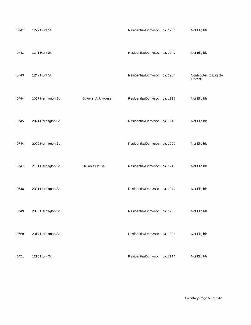
0741 1229 Hunt St. Residential/Domestic ca. 1930 Not Eligible
0742 1241 Hunt St. Residential/Domestic ca. 1940 Not Eligible
0743 1247 Hunt St. Residential/Domestic ca. 1930 Contributes to Eligible District
0744 2007 Harrington St. Bowers, A.J. House Residential/Domestic ca. 1925 Not Eligible
0745 2021 Harrington St. Residential/Domestic ca. 1940 Not Eligible
0746 2029 Harrington St. Residential/Domestic ca. 1920 Not Eligible
0747 2101 Harrington St Dr. Able House Residential/Domestic ca. 1915 Not Eligible
0748 2301 Harrington St. Residential/Domestic ca. 1940 Not Eligible
0749 2305 Harrington St. Residential/Domestic ca. 1905 Not Eligible
0750 2317 Harrington St. Residential/Domestic ca. 1905 Not Eligible
0751 1210 Hunt St. Residential/Domestic ca. 1910 Not Eligible
Inventory Page 57 of 142

0752 1218 Hunt St. Residential/Domestic ca. 1910 Not Eligible
0753 1224 Hunt St. Residential/Domestic ca. 1945 Not Eligible
0754 1240 Hunt St. Residential/Domestic ca. 1930 Not Eligible
0755 1248 Hunt St. Residential/Domestic ca. 1930 Contributes to Eligible District
0756 1254 Hunt St. Residential/Domestic ca. 1905 Contributes to Eligible District
0757 1310 Hunt St. Newberry County Hospital Health Care ca. 1925 Eligible
0758 2306 Harrington St Doctor's Building Residential/Domestic ca. 1950 Not Eligible
0759 1915 Harrington St. Residential/Domestic ca. 1910 Contributes to Listed District
0760 1935 Harrington St. Residential/Domestic ca. 1910 Not Eligible
0761 1941 Harrington St. Residential/Domestic ca. 1945 Not Eligible
0762 1241 Crenshaw St. Yeomans House Residential/Domestic ca. 1940 Contributes to Eligible District
Inventory Page 58 of 142

0763 1236 Crenshaw St. Residential/Domestic ca. 1940 Contributes to Eligible District
0764 1230 Crenshaw St. Residential/Domestic ca. 1935 Contributes to Eligible District
0765 1227 Crenshaw St. Residential/Domestic ca. 1940 Contributes to Eligible District
0766 1228 Crenshaw St. Residential/Domestic ca. 1940 Contributes to Eligible District
0768 1219 Crenshaw St. Residential/Domestic ca. 1925 Contributes to Eligible District
0769 1213 Crenshaw St. Pearson House Residential/Domestic ca. 1850 Contributes to Listed District
0770 1806 Harper St. Residential/Domestic ca. 1930 Contributes to Eligible District
0771 1808 Harper St. Residential/Domestic ca. 1930 Contributes to Eligible District
0772 1810 Harper St. Residential/Domestic ca. 1940 Contributes to Eligible District
0773 1907 Harrington St. Residential/Domestic ca. 1910 Contributes to Listed District
0774 1905 Harrington St. Residential/Domestic ca. 1930 Contributes to Listed District
Inventory Page 59 of 142

0775 1901 Harrington St. Residential/Domestic ca. 1920 Contributes to Listed District
0776 1827 Harrington St. Residential/Domestic ca. 1910 Contributes to Listed District
0777 1817 Harrington St. Residential/Domestic ca. 1950 Contributes to Listed District
0778 1809 Harrington St. Residential/Domestic ca. 1935 Contributes to Listed District
0779 1721 Harrington St. Residential/Domestic ca. 1930 Not Eligible
0780 1934 Harper St. Residential/Domestic ca. 1905 Contributes to Eligible District
0781 1922 Harper St. Residential/Domestic ca. 1945 Contributes to Eligible District
0782 1906 Harper St. Residential/Domestic ca. 1910 Contributes to Eligible District
0783 1912 Harper St. Residential/Domestic ca. 1910 Contributes to Eligible District
0784 1920 Harper St. Residential/Domestic ca. 1930 Contributes to Eligible District
0785 corner of Main & Calhoun Sts. Newberry Associated Religious 1907 Contributes to Listed Reformed Presbyterian District Church
Inventory Page 60 of 142

0786 1206 Calhoun St. Newberry ARP Parsonage Residential/Domestic ca. 1910 Contributes to Listed District
0787 1208 Calhoun St. McCaughrin House Residential/Domestic ca. 1908 Contributes to Listed District
0788 1212 Calhoun St. Parr House Residential/Domestic ca. 1910 Contributes to Listed District
0789 1220 Calhoun St. Residential/Domestic ca. 1895 Contributes to Listed District
0790 1226 Calhoun St. Residential/Domestic ca. 1870 Contributes to Listed District
0791 1234 Calhoun St. Wiseman House Residential/Domestic ca. 1870 Contributes to Listed District
0792 1240 Calhoun St. Residential/Domestic ca. 1900 Contributes to Listed District
0793 1714 Harper St. Residential/Domestic ca. 1950 Not Eligible
0794 1718 Harper St. Residential/Domestic ca. 1945 Not Eligible
0795 1720 Harper St. Residential/Domestic ca. 1950 Contributes to Eligible District
0796 1724 Harper St. Green's Boarding House Residential/Domestic ca. 1910 Contributes to Eligible District
Inventory Page 61 of 142

0797 1231 Walnut St. Residential/Domestic ca. 1925 Contributes to Eligible District
0798 DeWalt House/Mayer Reed Residential/Domestic ca. 1830, Contributes to Listed House 1905 District
0799 1214 Walnut St. Residential/Domestic ca. 1930 Contributes to Eligible District
0800 1218 Walnut St. Residential/Domestic ca. 1930 Contributes to Eligible District
0801 1224 Walnut St. Residential/Domestic ca. 1935 Contributes to Eligible District
0802 1228 Walnut St. Holmes House Residential/Domestic ca. 1880 Contributes to Eligible District
0803 1234 Walnut St. Residential/Domestic ca. 1925 Contributes to Eligible District
0804 1724 Main St. Ramage House Residential/Domestic ca. 1855 Contributes to Listed District
0805 1108 Amelia St. Residential/Domestic ca. 1950 Not Eligible
0806 1804 Main St. Hipp House Residential/Domestic ca. 1903 Contributes to Listed District
0807 1805 Main St. Yeoman House Residential/Domestic ca. 1920 Contributes to Listed District
Inventory Page 62 of 142

0808 1810-1812 Main St Residential/Domestic ca. 1946 Contributes to Listed District
0809 1817 Main St. Residential/Domestic ca. 1910 Contributes to Listed District
0810 1818 Main St. Residential/Domestic ca. 1920 Contributes to Listed District
0811 1822 Main St. Residential/Domestic ca. 1875 Contributes to Listed District
0812 1110 Cheatham St. Residential/Domestic ca. 1950 Not Eligible
0813 1902 Main St. Residential/Domestic ca. 1935 Contributes to Listed District
0814 1903 Main St. Residential/Domestic ca. 1925 Contributes to Listed District
0815 1905 Main St. Williams-Farr House Residential/Domestic ca. 1848 Contributes to Listed District
0816 1908 Main St. Residential/Domestic ca. 1905 Contributes to Listed District
0817 1912 Main St. Residential/Domestic ca. 1910 Contributes to Listed District
0818 1921 Main St. Residential/Domestic ca. 1905 Contributes to Listed District
Inventory Page 63 of 142

0819 1927 Main St. Residential/Domestic ca. 1910 Contributes to Listed District
0820 1933 Main St. Residential/Domestic ca. 1910 Contributes to Listed District
0821 2000 Main St. Residential/Domestic ca. 1910 Contributes to Listed District
0822 2004 Main St. Residential/Domestic ca. 1925 Contributes to Listed District
0823 2012 Main St. Residential/Domestic ca. 1910 Contributes to Listed District
0824 2016 Main St. Old Summer House Residential/Domestic ca. 1890 Contributes to Listed District
0825 2026 Main St. Summer-Ragland House Residential/Domestic ca. 1910 Contributes to Listed District
0826 2102 Main St. Summer House Residential/Domestic ca. 1950 Contributes to Listed District
0827 2112 Main St. Hanna House Residential/Domestic ca. 1895 Contributes to Listed District
0828 2200 Main St. Residential/Domestic ca. 1940 Contributes to Eligible District
0829 2206 Main St. Residential/Domestic ca. 1935 Contributes to Eligible District
Inventory Page 64 of 142

0830 2214 Main St. Residential/Domestic ca. 1935 Contributes to Eligible District
0831 2230 Main St. Residential/Domestic ca. 1940 Contributes to Eligible District
0832 2305 Main St. Residential/Domestic ca. 1910 Contributes to Eligible District
0833 2304 Main St. Residential/Domestic ca. 1900 Contributes to Eligible District
0834 2307 Main St. Residential/Domestic ca. 1930 Contributes to Eligible District
0835 2308 Main St. Residential/Domestic ca. 1910 Contributes to Eligible District
0836 2309 Main St. Residential/Domestic ca. 1940 Contributes to Eligible District
0837 2319 Main St. Residential/Domestic ca. 1910 Contributes to Eligible District
0838 2400 Main St. Residential/Domestic ca. 1935 Contributes to Eligible District
0839 2401 Main St. Residential/Domestic ca. 1905 Contributes to Eligible District
0840 2404 Main St. Residential/Domestic ca. 1905 Contributes to Eligible District
Inventory Page 65 of 142

0841 2405 Main St Residential/Domestic ca. 1910 Contributes to Eligible District
0842 2417 Main St. Commercial ca. 1950 Contributes to Eligible District
0843 2430 Main St. Norris House Residential/Domestic ca. 1875 Contributes to Eligible District
0844 2505 Main St. Commercial ca. 1950 Not Eligible
0845 2507 Main St. Commercial ca. 1930 Not Eligible
0846 2517 Main St. Residential/Domestic ca. 1930 Not Eligible
0847 2518 Main St. Residential/Domestic ca. 1930 Not Eligible
0848 2522 Main St. Heller's Grocery Commercial ca. 1925 Not Eligible
0849 2635 Main St. Dehines House Residential/Domestic ca. 1925 Not Eligible
0850 1831 Johnstone St. Residential/Domestic ca. 1890 Not Eligible
0851 1903 Johnstone St. Residential/Domestic ca. 1940 Not Eligible
Inventory Page 66 of 142

0852 1933 Johnstone St. Residential/Domestic ca. 1940 Not Eligible
0853 2003 Johnstone St. Residential/Domestic ca. 1910 Not Eligible
0854 2014 Johnstone St. Residential/Domestic ca. 1940 Not Eligible
0855 2023 Johnstone St. Residential/Domestic ca. 1900 Not Eligible
0856 2024 Johnstone St. Residential/Domestic ca. 1935 Not Eligible
0857 2026 Johnstone St. Residential/Domestic ca. 1910 Not Eligible
0858 2108 Johnstone St. Residential/Domestic ca. 1910 Not Eligible
0859 2106 Johnstone St. Residential/Domestic ca., 1930 Not Eligible
0860 2107 Johnstone St. Bynum House Residential/Domestic ca. 1900 Not Eligible
0861 1102 Hunt St. Residential/Domestic ca. 1910 Not Eligible
0862 2203 Johnstone St. Residential/Domestic ca. 1930 Not Eligible
Inventory Page 67 of 142

0863 2230 Johnstone St. Residential/Domestic ca. 1940 Not Eligible
0864 2305 Johnstone St. Residential/Domestic ca. 1935 Not Eligible
0865 2308 Johnstone St. Commercial ca. 1950 Not Eligible
0866 2309 Johnstone St. Residential/Domestic ca. 1935 Not Eligible
0867 2313 Johnstone St. Lipscomb Jewelry Commercial ca. 1950 Not Eligible
0868 2330 Johnstone St. Residential/Domestic ca. 1920 Not Eligible
0869 2331 Johnstone St. Residential/Domestic ca. 1935 Not Eligible
0870 2401 Johnstone St. Residential/Domestic c. 1930 Not Eligible
0871 2403 Johnstone St. Residential/Domestic ca. 1950 Not Eligible
0872 2404 Johnstone St. Residential/Domestic ca. 1930 Not Eligible
0873 2405 Johnstone St. Residential/Domestic ca. 1930 Not Eligible
Inventory Page 68 of 142
0874 2408 Johnstone St. Residential/Domestic ca. 1955 Not Eligible
0875 Johnstone St. Commercial ca. 1950 Not Eligible
0876 2415 Johnstone St. Residential/Domestic ca. 1880 Not Eligible
0877 2416 Johnstone St. Residential/Domestic ca. 1900 Not Eligible
0878 2501 Johnstone St. Residential/Domestic ca. 1930 Not Eligible
0879 2503 Johnstone St. Residential/Domestic ca. 1920 Not Eligible
0880 2505 Johnstone St. Residential/Domestic ca. 1940 Not Eligible
0881 2506 Johnstone St. Residential/Domestic ca. 1930 Not Eligible
0882 2507 Johnstone St. Residential/Domestic ca. 1930 Not Eligible
0883 2509 Johnstone St. Residential/Domestic ca. 1920 Not Eligible
0884 behind 2511 Johnstone St. Residential/Domestic ca. 1900 Not Eligible
Inventory Page 69 of 142

0885 2513 Johnstone St. Residential/Domestic ca. 1930 Not Eligible
0886 2534 Johnstone St. Residential/Domestic ca. 1950 Not Eligible
0887 2540 Johnstone St. Residential/Domestic ca. 1900 Not Eligible
0888 1217 Glenn St. Residential/Domestic ca. 1940 Contributes to Eligible District
0889 1227 Glenn St. Residential/Domestic ca. 1920 Contributes to Eligible District
0890 1231 Glenn St. Residential/Domestic ca. 1935 Contributes to Eligible District
0891 1109 Glenn St. Residential/Domestic ca. 1940 Not Eligible
0892 1113 Glenn St. Residential/Domestic ca. 1935 Not Eligible
0893 1114 Glenn St. Residential/Domestic ca. 1920 Not Eligible
0894 915-917 Glenn St. Residential/Domestic ca. 1945 Not Eligible
0895 1700 Boundary St. Coateswood / Johnstone, Residential/Domestic ca. 1842 Listed Job House
Inventory Page 70 of 142

0896 1526 Boundary St. Mower-Keitt House Residential/Domestic ca. 1890 Listed
0897 1520 Boundary St. Higgens, Francis Residential/Domestic ca. 1820 Listed House/Caldwell-Higgins House
0898 1516 Boundary St. McCrackin House Residential/Domestic ca. 1915 Not Eligible
0899 808 College St. Caldwell-Wright House Residential/Domestic ca. 1825 Contributes to Listed District
0900 811 College St. Jackson House Residential/Domestic ca. 1940 Not Eligible
0901 810 Caldwell St. Residential/Domestic ca. 1940 Not Eligible
0902 corner of Bou dary and First Baptist Church Religious ca. 1908 Contributes to Listed n Caldwell Sts. District
0903 800 Caldwell St. Hutchinson House Residential/Domestic ca. 1905 Not Eligible
0904 736 Caldwell St. Wright, Zach House Residential/Domestic ca. 1908 Contributes to Listed District
0905 737 Caldwell St. Summer House Residential/Domestic ca. 1925 Contributes to Listed District
0906 725 Caldwell St. Davis, C.C. House Residential/Domestic ca. 1892 Contributes to Listed District
Inventory Page 71 of 142

0907 722 Caldwell St. Houseal-Goggans House Residential/Domestic ca. 1895 Contributes to Listed District
0908 721 Caldwell St. Residential/Domestic ca. 1945 Contributes to Listed District
0909 719 Caldwell St. Residential/Domestic ca. 1945 Contributes to Listed District
0910 7123 Caldwell St. Cannon, Wright House Residential/Domestic ca. 1900 Contributes to Listed District
0911 709 Caldwell St. Boozer House Residential/Domestic ca. 1895 Contributes to Listed District
0912 707 Caldwell St. Residential/Domestic ca. 1905 Contributes to Listed District
0913 703 Caldwell St. Residential/Domestic ca. 1910 Contributes to Listed District
0914 636 Caldwell St. Residential/Domestic ca. 1910 Contributes to Listed District
0915 631 Caldwell St. Residential/Domestic ca. 1900 Not Eligible
0916 2003 Harrington St. Hipp House Residential/Domestic ca. 1930 Not Eligible
0917 931 Boundary St. Residential/Domestic ca. 1910 Not Eligible
Inventory Page 72 of 142
0918 Boundary St. Bridge Transportation 1925 Not Eligible
0919 901 Boundary St. Residential/Domestic ca. 1870 Contributes to Listed District
0920 900 Boundary St. Residential/Domestic ca. 1900 Contributes to Listed District
0921 824 Boundary St. Residential/Domestic ca. 1925 Contributes to Listed District
0922 820 Boundary St. Residential/Domestic ca. 1855 Contributes to Listed District
0923 819 Boundary St. Residential/Domestic ca. 1870 Contributes to Listed District
0924 817 Boundary St. Residential/Domestic ca. 1910 Contributes to Listed District
0925 808 Boundary St. Ruff, Pressley ouse, Residential/Domestic ca. 1856 Contributes to Listed H Wicker House District
0926 807 Boundary St. Residential/Domestic ca. 1870 Contributes to Listed District
0927 800 Boundary St. Residential/Domestic ca. 1940 Contributes to Listed District
0928 734 Boundary St. Pratt House Residential/Domestic c. 1840 Contributes to Listed District
Inventory Page 73 of 142

0929 733 Boundary St. Gilder House Residential/Domestic c. 1895 Contributes to Listed District
0930 726 Boundary St. Residential/Domestic ca. 1905 Contributes to Listed District
0931 723 Boundary St. Residential/Domestic ca. 1890 Contributes to Listed District
0932 722 Boundary St. Merchant House Residential/Domestic ca. 1900 Contributes to Listed District
0933 713 Boundary St. Residential/Domestic ca. 1930 Contributes to Eligible District
0934 709 Boundary St. Residential/Domestic ca. 1900 Contributes to Eligible District
0935 708 Boundary St. Residential/Domestic ca. 1925 Contributes to Eligible District
0936 706 Boundary St. Residential/Domestic ca. 1920 Contributes to Eligible District
0937 603 Boundary St. Langford House Residential/Domestic ca. 1920 Contributes to Eligible District
0938 540 Boundary St. Residential/Domestic ca. 1950 Contributes to Eligible District
0939 533 Boundary St. Residential/Domestic ca. 1920 Contributes to Eligible District
Inventory Page 74 of 142

0940 532 Boundary St. Residential/Domestic ca. 1920 Contributes to Eligible District
0941 519 Boundary St. Blease, Eugene House Residential/Domestic ca. 1925 Not Eligible
0942 515 Boundary St. Leavell House Residential/Domestic ca. 1875 Not Eligible
0943 516 Boundary St. Nance, Erasmus House / Residential/Domestic ca. 1850 Not Eligible Havird House
0944 1938 Harrington St. Residential/Domestic ca. 1935 Not Eligible
0945 826 Drayton Street Residential/Domestic circa 1935 Not Eligible
0946 827 Drayton Street Residential/Domestic circa 1940 Not Eligible
0947 824 Drayton Street Residential/Domestic circa 1920 Not Eligible
0948 823 Drayton Street Residential/Domestic circa 1910 Not Eligible
0949 726 Drayton Street Residential/Domestic circa 1900 Not Eligible
0950 723 Drayton Street Residential/Domestic circa 1910 Not Eligible
Inventory Page 75 of 142

0951 715 Drayton Street Residential/Domestic circa 1870 Not Eligible
0952 713 Drayton Street Residential/Domestic circa 1930 Not Eligible
0953 Drayton Street Commercial circa 1900 Not Eligible
0954 621 Drayton Street Residential/Domestic circa 1910 Not Eligible
0955 Drayton Street Drayton Street School Educational circa 1925 Not Eligible
0956 704 McSwain Street Residential/Domestic circa 1900 Not Eligible
0957 711 McSwain Street Residential/Domestic circa 1920 Not Eligible
0958 619 South Street Residential/Domestic circa 1905 Not Eligible
0959 808 Langford Street Residential/Domestic circa 1900 Not Eligible
0960 813 Langford Street Residential/Domestic circa 1930 Not Eligible
0961 820 Langford Street Residential/Domestic circa 1920 Not Eligible
Inventory Page 76 of 142

0962 818 James Street Residential/Domestic circa 1910 Not Eligible
0963 921 Jessica Avenue Oak Grove, Gildercrest, Residential/Domestic circa 1822 Contributes to Listed Frederick Nance House District
0964 901 Nance Street Residential/Domestic circa 1900 Not Eligible
0965 907 Nance Street Residential/Domestic circa 1940 Not Eligible
0966 909 Nance Street Residential/Domestic circa 1910 Not Eligible
0967 1009 Nance Street Commercial circa 1925 Not Eligible
0968 938 Friend Street Commercial circa 1930 Not Eligible
0969 935 Friend Street Commercial circa 1890 Not Eligible
0970 911 Friend Street Commercial crca 1950 Not Eligible
0971 901 Friend Street Thomas & Howard Commercial circa 1925 Not Eligible
0972 1101 Nance Street Commercial circa 1890 Not Eligible
Inventory Page 77 of 142

0973 944 Main Street Newberry Drug Company Commercial circa 1890 Not Eligible
0974 942 Main Street Newberry Feed & Seed Commercial circa 1890 Not Eligible
0975 934 Main Street Newberry Steam Laundry Commercial circa 1895 Not Eligible
0976 932 Main Street Werts Music Commercial circa 1940 Not Eligible
0977 904, 906, 908, 910, 912 Main Commercial circa 1890 Not Eligible Street
0978 905 Main Street Newberry Creamery Commercial circa 1900 Not Eligible
0979 Railroad over Scott's Creek Transportation Not Eligible
0980 910 Harrington Street Commercial circa 1950 Not Eligible
0981 Victory Street Commercial circa 1950 Not Eligible
0982 1229 Nance Street Commercial circa 1950 Not Eligible
0983 1223 Nance Street Commercial circa 1930 Not Eligible
Inventory Page 78 of 142

0984 1215 Nance Street Commercial circa 1950 Not Eligible
0985 Bachman Street ( ewberry MacLean Gymnasium Educational circa 1925 Contributes to Listed N College Campus) District
0986 Newberry College Campus Holland Hall Educational circa 1900 Contributes to Listed District
0987 Newberry College Campus Derrick Hall Educational circa 1910 Contributes to Listed (Evans Street side) District
0988 Newberry College Campus Wiles Chapel Educational circa 1965 Not Eligible
0989 2000 College Street Smeltzer Hall Educational circa 1878 Contributes to Listed District
0990 Newberry College Campus Keller Hall Educational 1895 Contributes to Listed District
0991 1330 Evans Street Residential/Domestic circa 1900 Not Eligible
0992 1910 College Street Residential/Domestic circa 1950 Not Eligible
0993 1900 College Street Evans-Dufford Residential/Domestic circa 1910 Contributes to Listed District
0994 1814 College Street Residential/Domestic circa 1870 Contributes to Listed District
Inventory Page 79 of 142

0995 1806 College Street Residential/Domestic circa 1890 Contributes to Listed District
0996 1800 College Street Residential/Domestic circa 1875 Contributes to Listed District
0997 1720 College Street Moore House Residential/Domestic circa 1890 Contributes to Listed District
0998 1710 College Street Welch House Residential/Domestic circa 1897 Contributes to Listed District
0999 1704 College Street Leavell House Residential/Domestic circa 1880 Contributes to Listed District
1000 1602 Calhoun Street Residential/Domestic circa 1925 Not Eligible
1001 1530 Calhoun Street Lindsay House Residential/Domestic circa 1900 Not Eligible
1002 1808 Lindsay Street Residential/Domestic circa 1900 Not Eligible
1003 1810 Lindsay Street Residential/Domestic circa 1910 Not Eligible
1004 1811 Lindsay Street Residential/Domestic circa 1920 Not Eligible
1005 1909 Luther Street Residential/Domestic circa 1910 Not Eligible
Inventory Page 80 of 142

1006 1603 Evans Street Residential/Domestic circa 1910 Not Eligible
1043 College Street Rosemont Cemetery Funerary founded Not Eligible 1863
1044 1130 Douglas Street Residential/Domestic circa 1910 Not Eligible
1045 1121 Summer Street Residential/Domestic circa 1910 Not Eligible
1047 1130 Summer Street Residential/Domestic circa 1875 Not Eligible
1048 1138 Summer Street Residential/Domestic circa 1930 Not Eligible
1049 1219 Kinard Street Residential/Domestic circa 1905 Not Eligible
1050 1220 Kinard Street Residential/Domestic circa 1930 Not Eligible
1051 1223 Kinard Street Residential/Domestic circa 1930 Not Eligible
1052 2516 Kinard Street Residential/Domestic circa 1910 Not Eligible
1053 914 Glenn Street Residential/Domestic circa 1920 Not Eligible
Inventory Page 81 of 142
1054 900 Glenn Street Residential/Domestic circa 1910 Not Eligible
1055 822 Glenn Street Residential/Domestic circa 1900 Not Eligible
1056 818 Glenn Street Residential/Domestic circa 1915 Not Eligible
1057 806 Glenn Street Residential/Domestic circa 1910 Not Eligible
1058 1934 Johnstone Street Margarette Apartments Residential/Domestic circa 1948 Not Eligible
1059 1427 Ebennezer Road Timberhouse, Jacob Kibler Residential/Domestic circa 1855 Listed House
1060 84 Nance Street Cousins House Residential/Domestic circa 1880 Listed
1061 1800 Johnstone Street Regnery House Residential/Domestic circa 1948 Not Eligible
1062 1100 Calhoun Street Kinard House Residential/Domestic circa 1875 Not Eligible
1063 1735 Johnstone Street Gray-Ellesor House Residential/Domestic circa 1890 Not Eligible
1065 630 Caldwell Street Ruff's Feed & Seed Commercial circa 1900 Not Eligible
Inventory Page 82 of 142

1066 Coate's Street behind Village Cemetery Funerary begun Contributes to Listed Boundary Street School 1822 District
1067 1727 Harrington Street Maybin-Poole House Residential/Domestic 1871 Contributes to Listed District
1068 Residential/Domestic ca. 1920 Not Eligible
1069 1223 Summer Street Residential/Domestic circa 1920 Contributes to Eligible District
1070 1719 Harrington Street Residential/Domestic circa 1930 Not Eligible
1442 2397 Oxner Rd. Residential/Domestic ca. 1920 Not Eligible
1443 1415 Halfacre Rd. Gallman House Residential/Domestic 1860 Not Eligible
1444 334 Clayton Memorial Church Halfacre Church Religious ca. 1907 Not Eligible Rd.
1445 1299 Halfacre Rd. Residential/Domestic ca. 1910 Not Eligible
1446 3530 SC 219 Residential/Domestic ca. 1920 Not Eligible
1447 Mud Creek Rd., W side, Residential/Domestic ca. 1915 Not Eligible approx. 200 yds N of int. w/ SC 219
Inventory Page 83 of 142

1448 3945 Hwy 219 Residential/Domestic ca. 1920 Not Eligible
1449 NE corner of int. of SC 219 Commercial ca. 1920 Not Eligible and Sease Rd.
1450 SC 219, S side, across from Commercial ca. 1920 Not Eligible int. w/ Sease Rd.
1451 SC 219, N side, approx. 100 Residential/Domestic ca. Not Eligible yds. W of int. w/ Sease Rd. 1910-15
1452 SC 219, N side, approx. 300 Residential/Domestic ca. 1920 Not Eligible yds. W of int. w/ Sease Rd.
1453 SC 219, S side, approx. 1/4 Residential/Domestic ca. Not Eligible mi. W of int. w/ Sease Rd. 1925-30
1454 3926 SC 219 Residential/Domestic ca. Not Eligible 1915-20
1455 4023 SC 219 Residential/Domestic ca. 1915 Not Eligible
1456 SW corner of int. of Hillbrook Residential/Domestic ca. 1920 Not Eligible Ln. & Hwy 34
1457 Hwy 34, E side, approx. 200 Residential/Domestic ca. 1930 Not Eligible yds. N of int. w/ I-26
1458 Hwy 34, E side, approx. 200 Unknown ca. Not Eligible yds. N of int. w/ I-26 1925-30
Inventory Page 84 of 142

1459 11592 Hwy 34 Unknown ca. 1920 Not Eligible
1460 SE corner of int. of General Residential/Domestic ca. 1920 Not Eligible Henderson Rd. & Mt. Bethel Garmany Rd.
1461 2408 Mt. Bethel Garmany Rd. Residential/Domestic ca. 1880 Not Eligible
1462 2344 Mt. Bethel Garmany Rd. Residential/Domestic ca. 1900 Not Eligible
1463 3253 Mt. Bethel Garmany Rd. Residential/Domestic ca. 1890 Not Eligible
1464 Kingscreek Rd. Residential/Domestic ca. Not Eligible 1925-30
1465 Beth Eden Rd., N side, Beth Eden Lutheran Church Religious 1945 Not Eligible approx. 1/4 mi. W of int. w/ Old Whitmire Hwy
1466 Kings Creek Rd., N side, Residential/Domestic ca. 1920 Not Eligible approx. 1 mi. E of int. w/ Old Whitmire Hwy.
1467 SC 121, E side, approx. 3/4 Residential/Domestic ca. 1920 Not Eligible mi. N of int. w/ Kings Creek Rd.
1468 Mt. Bethel Garmany Rd., W Educational 1924-25 Not Eligible side, approx. 1/2 mi. N of int. w/ Kings Creek Rd.
1469 3607 Mt. Bethel Garmany Rd. Residential/Domestic ca. Not Eligible 1920-25
Inventory Page 85 of 142

1470 Mt. Bethel Garmany Rd., E Residential/Domestic ca. 1900 Not Eligible side, approx. 1/2 mi. N of int. w/ Kings Creek Rd.
1471 397 Mt. Bethel Garmany Rd. Lebanon United Methodist Religious ca. 1930 Not Eligible Church
1472 Mt. Bethel Garmany Rd., W Residential/Domestic ca. 1900 Not Eligible side, approx. 1 mi. N of int. w/ Kings Creek Rd.
1473 4306 Mt. Bethel Garmany Rd. Chalmers-Brown House Residential/Domestic ca. 1840 Not Eligible
1474 4545 Mt. Bethel Garmany Rd. Residential/Domestic ca. 1920 Not Eligible
1475 4767 Mt. Bethel Garmany Rd. Residential/Domestic ca. Not Eligible 1910-15
1476 3288 Bachman Chapel Rd. Residential/Domestic ca. 1910 Not Eligible
1477 Bachman Chapel Rd., E side, Residential/Domestic ca. 1930 Not Eligible approx. 1/2 mi. N of int. w/ Union School Rd.
1478 Jollystreet Rd., S side, Residential/Domestic ca. 1900 Not Eligible approx. 1/4 mi. E of int. w/ Strauss Rd.
1479 SE corner of int. of Jollystreet Residential/Domestic ca. 1930 Not Eligible Rd. & Claude Counts Rd.
1480 5129 Jollystreet Rd. Residential/Domestic ca. 1910 Not Eligible
Inventory Page 86 of 142

1481 Jollystreet Rd., S side, Residential/Domestic ca. Not Eligible approx. 1/2 mi. W of int. w/ 1925-30 Claude Counts Rd.
1482 7573 Jollystreet Rd. Residential/Domestic ca. 1930 Not Eligible
1483 1175 Morningside Dr. Residential/Domestic ca. 1930 Not Eligible
1484 Hwy 76, W side, approx. 1/4 Residential/Domestic ca. 1940 Not Eligible mi. S of int. w/ Adelaide St.
1485 2450 Adelaide St. Residential/Domestic ca. 1925 Not Eligible
1486 2331 Adelaide St Residential/Domestic ca. 1940 Not Eligible
1487 Adelaide St., S side, approx. Unknown ca. 1930 Not Eligible 3/4 mi. W of int. w/ Hwy 76
1488 2220 Adelaide St. Residential/Domestic ca. 1925 Not Eligible
1489 2216 Adelaide St. Residential/Domestic ca. Not Eligible 1940-50
1490 2212 Adelaide St. Residential/Domestic ca. 1920 Not Eligible
1491 Adelaide St., S side, approx. Residential/Domestic ca. 1930 Not Eligible 200 yds. E of int. w/
Inventory Page 87 of 142

1492 2204 Adelaide St. Residential/Domestic ca. 1930 Not Eligible
1493 2162 Residential/Domestic ca. 1930 Not Eligible
1494 2158 Residential/Domestic ca. 1930 Not Eligible
1495 2154 Residential/Domestic ca. 1920 Not Eligible
1496 2146 Adelaide St. Residential/Domestic ca. 1920 Not Eligible
1497 2144 Adelaide St. Residential/Domestic ca. 1930 Not Eligible
1498 2142 Adelaide St. Residential/Domestic ca.1930 Not Eligible
1499 2140 Adelaide St. Residential/Domestic ca. 1930 Not Eligible
1500 Hwy 76, W side, approx. 200 Residential/Domestic ca. 1925 Not Eligible yds. S of int. w/ Jollystreet Rd.
1501 14820 Hwy 76 Residential/Domestic ca. 1915 Not Eligible
1502 Hwy 76, W side, approx. 1/4 Residential/Domestic ca. 1915 Not Eligible mi. S of int. w/ Jollystreet Rd.
Inventory Page 88 of 142

1503 Mt. Bethel Garmany Rd., E Residential/Domestic ca. 1910 Not Eligible side, approx. 100 yds. N of int. w/ SC 34
1504 323 Mt. Bethel Garmany Rd. Residential/Domestic ca. 1925 Not Eligible
1505 206 Pender Ridge Residential/Domestic ca. 1915 Not Eligible
1506 Whitener Rd., S side, approx. Residential/Domestic ca. Not Eligible 1/4 mi. W of int. w/ Mt. Bethel 1925-30 Garmany Rd.
1507 568 Pender Ridge Rd. Residential/Domestic ca. 1930 Not Eligible
1508 2118 Wilson Rd. (Hwy 76) Residential/Domestic ca. 1945 Not Eligible
1509 N corner of int. of Wilson Rd. Residential/Domestic ca. 1945 Not Eligible (Hwy 76) and Pine Lane Rd.
1510 2202 Wilson Rd. (Hwy 76) Residential/Domestic ca. 1940 Not Eligible
1511 2209 Wilson Rd. (Hwy 76) Residential/Domestic ca. 1930 Not Eligible
1512 2215 Wilson Rd. (Hwy 76) Residential/Domestic ca. 1945 Not Eligible
1513 2217 Wilson Rd. (Hwy 76) Residential/Domestic ca. 1925 Not Eligible
Inventory Page 89 of 142

1514 2221Wilson Rd. Residential/Domestic ca. 1925 Not Eligible
1515 2230 Wilson Rd. (Hwy 76) Residential/Domestic ca. Not Eligible 1945-50
1516 2222 Wilson Rd. (Hwy 76) Residential/Domestic ca. 1940 Not Eligible
1517 2230 Wilson Rd. Residential/Domestic ca. 1925 Not Eligible
1518 1602 Whitener Rd. Residential/Domestic ca. 1925 Not Eligible
1519 11665 SC 121 Residential/Domestic ca. 1915 Not Eligible
1520 12355 SC 121 Residential/Domestic ca. 1925 Not Eligible
1521 598 Folk Rd. Residential/Domestic ca. 1920 Not Eligible
1522 NE corner of int. of Hwy 76 & Commercial ca. 1935 Not Eligible SC 121
1523 296 Old Whitmire Hwy Residential/Domestic ca. 1925 Not Eligible
1524 228 Old Whitmire Hwy Residential/Domestic ca. 1930 Not Eligible
Inventory Page 90 of 142
1525 166 Old Whitmire Hwy Residential/Domestic ca. 1940 Not Eligible
1526 SC 121, E side, approx. 50 Residential/Domestic ca. 1925 Not Eligible yds. S of int. w/ Hwy 76
1527 SC 121, E side, approx. 1/4 Commercial ca. 1930 Not Eligible mi. S of int. w/ Hwy 76
1528 SC 121, E side, approx. 1/2 Residential/Domestic ca. 1945 Not Eligible mi. S of int. w/ Hwy 76
1529 sc 121, W side, approx. 3/4 Residential/Domestic ca. 1910 Not Eligible mi. S of int. w/ Hwy 76
1530 SC 121, W side, approx. 3/4 Residential/Domestic ca. 1925 Not Eligible mi. S of int. w/ Hwy 76
1531 3271 SC 121 Residential/Domestic ca. 1925 Not Eligible
1532 3273 SC 121 Residential/Domestic ca. 1925 Not Eligible
1533 3293 SC 121 Residential/Domestic ca. 1920 Not Eligible
1534 4011 SC 121 Residential/Domestic ca. 1925 Not Eligible
1535 4015 SC 121 Residential/Domestic ca. 1925 Not Eligible
Inventory Page 91 of 142

1536 915 Oxner Rd. Residential/Domestic ca. 1920 Not Eligible
1537 469 Oxner Rd. Residential/Domestic ca. 1910 Not Eligible
1538 202 Oxner Rd. Residential/Domestic ca. 1930 Not Eligible
1539 824 Piester Rd. Residential/Domestic ca. 1910 Not Eligible
1540 35 Piester Rd. Residential/Domestic ca. 1925 Not Eligible
1541 4176 St. Phillips Church Rd. Residential/Domestic ca. 1910 Not Eligible
1542 St. Phillips Church Rd., W Leitzsey School Educational 1928 Not Eligible side, approx. 1/2 mi. N of int. w/ SC 219
1543 SC 34, N side, approx. 100 Residential/Domestic ca. 1915 Not Eligible yds. E of int. w/ General Henderson Rd.
1544 10465 SC 34 Residential/Domestic ca. 1925 Not Eligible
1545 SC 34, S side, approx. 3/4 mi. Residential/Domestic ca. 1910 Not Eligible W of int. w/ Hwy 176
1546 337 Rutherford Rd. Gist House Residential/Domestic ca. 1855 Eligible
Inventory Page 92 of 142

1547 end of Dove Dr. New Enoree Baptist Church Religious ca. 1880 Not Eligible
1548 15968 Hwy 176 Caldwell, Thomas Wilson Residential/Domestic ca. 1840 Eligible House
1549 5935 Mt. Bethel Garmany Rd. Residential/Domestic ca. 1910 Not Eligible
1550 5607 Mount Bethel Garmany Residential/Domestic ca. 1880 Not Eligible Rd.
1551 SW corner of int. of Hwy 76 & Residential/Domestic ca. 1930 Not Eligible Whitener Rd.
1765 14461 Hwy 76 Residential/Domestic ca. 1930 Not Eligible
1766 Hwy 76, E side, approx. 1/2 Commercial ca. 1930 Not Eligible mi. S of int. w/ Jollystreet Rd.
Newberry NW Site No Address/Location Historic Name Historic Use Date Eligibility
1562 Old Newberry Hwy, S side, Residential/Domestic ca. 1935 Not Eligible approx. 1/2 mi. E of int. w/ SC 66
1563 8857 Jalapa Rd. Residential/Domestic ca Not Eligible 1860-70
1564 6841 Jalapa Rd. Residential/Domestic ca. 1920 Not Eligible
Inventory Page 93 of 142

1565 Beth Eden Rd., W side, Residential/Domestic ca. 1860 Not Eligible approx. 1 1/2 mi. E of int. w/ Jalapa Rd.
1566 3051 Indian Creek Rd. Residential/Domestic ca. 1925 Not Eligible
1567 Indian Creek Rd, W side, Residential/Domestic ca. Not Eligible approx. 1 mi. N of int. w/ Riser 1925-30 Rd.
1568 3295 SC 66 Residential/Domestic ca. 1930 Not Eligible
1569 2340 SC 66 Residential/Domestic ca. 1870 Not Eligible
1570 Hwy 66, N side, approx. 1/2 Residential/Domestic ca. 1915 Not Eligible mi. E of Brickhouse Crossroads
1571 5000 SC 66 Residential/Domestic ca. 1900 Not Eligible
Newberry W Site No Address/Location Historic Name Historic Use Date Eligibility
1572 1203 Jalapa Rd. Residential/Domestic ca. 1930 Not Eligible
1573 888 Jalapa Rd. Residential/Domestic ca. 1910 Not Eligible
1574 262 Jalapa Rd. Residential/Domestic ca. 1925 Not Eligible
Inventory Page 94 of 142

1575 23722 Hwy 76 Residential/Domestic ca. 1915 Not Eligible
1576 24352 Hwy 76 Residential/Domestic ca. 1925 Not Eligible
1577 24567 Hwy 76 Residential/Domestic ca. 1900 Not Eligible
1578 24919 Hwy 76 Residential/Domestic ca. 1920 Not Eligible
1579 26042 Hwy 76 Commercial ca. 1920 Not Eligible
1580 2076 Hwy 76 Residential/Domestic ca. 1900 Not Eligible
1581 2455 Reeder Rd. Residential/Domestic ca. 1925 Not Eligible
1582 6546 Bush River Rd. Residential/Domestic ca. 1915 Not Eligible
1583 6256 Bush River Rd. Residential/Domestic ca. 1925 Not Eligible
1584 6197 Bush River Rd. Residential/Domestic ca. 1925 Not Eligible
1585 5756 Bush River Rd. Residential/Domestic ca. 1910 Not Eligible
Inventory Page 95 of 142
1586 Beaverdam Church Rd., E Residential/Domestic ca. 1925 Not Eligible side, approx. 3/4 mi. N of int. w/ Rocky Creek Rd.
1587 Sterling Rd., S side, approx. Residential/Domestic ca. 1900 Not Eligible 1/4 mi. W of int. w/ Rocky Creek Rd.
1588 NW corner of int. of Island Commercial ca. 1930 Not Eligible Ford Rd. & Belfast Rd.
1589 2969 Trinity Church Rd. Residential/Domestic ca. 1940 Not Eligible
1590 580 Greentree Rd. Residential/Domestic ca. 1920 Not Eligible
1591 Spearman Rd., N side, approx. Residential/Domestic ca. 1925 Not Eligible 1 mi. W of int. w/ Belfast Rd.
1592 745 Field View Rd. Residential/Domestic ca. 1920 Not Eligible
1593 592 Field View Rd. Residential/Domestic ca. 1910 Not Eligible
1594 418 Field View Rd. Residential/Domestic ca. 1925 Not Eligible
1595 Stoney Battery Rd., E side, Residential/Domestic ca. 1915 Not Eligible approx. 1/2 mi. S of int. w/ Belfast Rd.
1596 1017 Rocky Creek Rd. Residential/Domestic ca. 1870 Not Eligible
Inventory Page 96 of 142

1597 5099 Belfast Rd. Residential/Domestic ca. 1930 Not Eligible
1598 1203 Belfast Rd. Residential/Domestic ca. 1945 Not Eligible
1599 Bush River Rd., S side, Residential/Domestic ca. 1880 Not Eligible approx. 3/4 mi. W of int. w/ Herman Wise Rd.
1600 Bush River Rd., S side, Commercial ca. 1925 Not Eligible approx. 1 mi. W of int. w/ Herman Wise Rd.
1601 4093 Bush River Rd. Residential/Domestic ca. 1925 Not Eligible
1602 4139 Bush River Rd. Residential/Domestic ca. 1940 Not Eligible
1603 Bush River Rd., S side, Residential/Domestic ca. 1910 Not Eligible approx. 1 mi. E of int. w/ Beaverdam Church Rd.
1604 Bush River Rd., N side, Residential/Domestic ca. 1920 Not Eligible approx. 3/4 mi. E of int. w/ Beaverdam Church Rd.
1605 5262 Bush River Rd. Residential/Domestic ca. 1930 Not Eligible
1606 4350 Beaverdam Church Rd. Residential/Domestic ca. 1920 Not Eligible
1607 Beaverdam Church Rd., E Residential/Domestic ca. 1890 Not Eligible side, approx. 100 yds. S of int. w/ Hwy 76
Inventory Page 97 of 142

1608 Hwy 76, S side, approx. 1/2 Residential/Domestic ca. 1920 Not Eligible mi. E of int. w/ Beaverdam Church Rd.
1609 1975 Herman Wise Rd. Residential/Domestic ca. 1925 Not Eligible
1610 1506 Herman Wise Rd. Residential/Domestic ca. 1910 Not Eligible
1611 1127 Herman Wise Rd. Residential/Domestic ca. 1915 Not Eligible
1612 757 Herman Wise Rd. Residential/Domestic ca. 1920 Not Eligible
1613 24 Airport Rd. Residential/Domestic ca. 1930 Not Eligible
1614 5105 Nance St. Residential/Domestic ca. 1930 Not Eligible
1615 Lumberyard Rd., W side, Residential/Domestic ca. 1925 Not Eligible approx. 30 yds. N of int. w/ Hwy 76
1616 20030 Hwy 76 Residential/Domestic ca. 1935 Not Eligible
1617 20286 Hwy 76 Residential/Domestic ca. 1925 Not Eligible
1618 20606 Hwy 76 Residential/Domestic ca. 1920 Not Eligible
Inventory Page 98 of 142
1619 Hwy 76, S side, approx. 100 Residential/Domestic ca. 1945 Not Eligible yds. W of int. w/ Herman Wise Rd.
1620 21866 Hwy 76 Residential/Domestic ca. 1880 Not Eligible
1621 Hwy 76, S side, approx. 1 mi. Residential/Domestic ca. Not Eligible W of int. w/ Herman Wise Rd. 1890-1900
1681 4184 Dennis Dairy Rd. Residential/Domestic ca. 1920 Not Eligible
Newberry West Site No Address/Location Historic Name Historic Use Date Eligibility
0462 1918 Nance St. Graham House Residential/Domestic ca. 1950 Not Eligible
0463 1924 Nance St. Residential/Domestic ca. 1940 Not Eligible
0464 1934 Nance St. Thompson-Whitaker House Residential/Domestic ca. 1910 Not Eligible
0471 1814 Nance St. Residential/Domestic ca. 1910 Not Eligible
0472 1830 Nance St. Park Service Station Commercial ca. 1930 Not Eligible
0475 1811 College St. John Scurry House Residential/Domestic ca. 1915 Contributes to Listed District
Inventory Page 99 of 142

0542 1500 Harris St. Residential/Domestic ca. 1935 Not Eligible
0543 1608 Harris St. Residential/Domestic ca. 1925 Not Eligible
0544 912 Cornelia St. Residential/Domestic ca. 1900 Not Eligible
0545 916 Cornelia St. Residential/Domestic ca. 1900 Not Eligible
0546 922 Cornelia St. Residential/Domestic ca. 1900 Not Eligible
0547 932 Cornelia St. Residential/Domestic ca. 1930 Not Eligible
0556 1412 Harris St. Residential/Domestic ca. 1900 Not Eligible
0557 1418 Harris St. Residential/Domestic ca. 1920 Not Eligible
0558 911 Horseshoe Circle Residential/Domestic ca. 1920 Not Eligible
0559 1502 Horseshoe Circle Residential/Domestic ca. 1930 Not Eligible
0560 1504 Horseshoe Circle Residential/Domestic ca. 1920 Not Eligible
Inventory Page 100 of 142

0561 1508 Horseshoe Circle Residential/Domestic ca. 1920 Not Eligible
0589 918 Fair St. Residential/Domestic ca. 1935 Not Eligible
0590 1909 Miller St. Residential/Domestic ca. 1935 Not Eligible
0591 1905 Miller St. Residential/Domestic ca. 1935 Not Eligible
0592 920 Fair St. Residential/Domestic ca. 1940 Not Eligible
0593 924 Fair St. Residential/Domestic ca. 1935 Not Eligible
0594 1935 Nance St. Residential/Domestic ca. 1925 Not Eligible
0595 1933 Nance St. Residential/Domestic ca. 1935 Not Eligible
0596 Nance St. Old Newberry High Educational ca. 1926 Not Eligible School/Old Newberry Middle School
0597 1809 Nance St. Hill, Juanita House Residential/Domestic ca. 1880 Not Eligible
0598 1803 Nance St Residential/Domestic ca. 1930 Not Eligible
Inventory Page 101 of 142

0599 949 Cline St. Residential/Domestic ca. 1940 Not Eligible
0600 945 Cline St. Residential/Domestic ca. 1940 Not Eligible
0601 943 Cline St. Residential/Domestic ca. 1930 Not Eligible
0602 941 Cline St. Residential/Domestic ca. 1925 Not Eligible
0603 937 Cline St. Residential/Domestic ca. 1920 Not Eligible
0604 933 Cline St. Riebe House Residential/Domestic ca. 1890 Not Eligible
0605 927 Cline St. Residential/Domestic ca. 1930 Not Eligible
0606 923 Cline St. Residential/Domestic ca. 1925 Not Eligible
0607 921 Cline St. Residential/Domestic ca. 1930 Not Eligible
0608 913 Cline St. Commercial ca. Not Eligible
0609 608 Pope St. Residential/Domestic ca. 1930 Not Eligible
Inventory Page 102 of 142

0610 2024 Vincent St. Residential/Domestic ca. 1925 Not Eligible
0611 1908 Vincent St. Residential/Domestic ca. 1900 Not Eligible
0612 1906 Vincent St. Residential/Domestic ca. 1930 Not Eligible
0613 1700 Vincent St. Livingston Cottage Residential/Domestic ca. 1875 Contributes to Listed District
0614 1706 Vincent St. Stevens Cottage Residential/Domestic ca. 1875 Contributes to Listed District
0615 1708 Vincent St. Commercial ca. 1930 Not Eligible
0616 1718 Vincent St. Residential/Domestic ca. 1935 Not Eligible
0617 behind 901 Cline St. Residential/Domestic ca. 1935 Not Eligible
0618 901 Cline St. Residential/Domestic ca. 1935 Not Eligible
0619 920 Cline St. Residential/Domestic ca. 1925 Not Eligible
0620 916 Cline St. Residential/Domestic ca. 1930 Not Eligible
Inventory Page 103 of 142

0621 1742 Harris St. Residential/Domestic ca. 1920 Not Eligible
0622 1738 Harris St. Residential/Domestic ca. 1920 Not Eligible
0623 1728 Harris St. Residential/Domestic ca. 1870 Not Eligible
0624 1722 Harris St. Residential/Domestic ca. 1900 Not Eligible
0625 1609 Moon St. Residential/Domestic ca. 1950 Not Eligible
0626 926 Cline St. Residential/Domestic ca. 1870 Not Eligible
0627 930 Cline St. Residential/Domestic ca. 1870 Not Eligible
0628 934 Cline St. Residential/Domestic ca. 1870 Not Eligible
0629 938 Cline St. Residential/Domestic ca. 1900 Not Eligible
0630 940 Cline St. Residential/Domestic ca. 1935 Not Eligible
0631 942 Cline St. Residential/Domestic ca. 1930 Not Eligible
Inventory Page 104 of 142

0632 944 Cline St. Residential/Domestic ca. 1935 Not Eligible
0633 946 Cline St. Residential/Domestic ca. 1930 Not Eligible
0644 931 Cornelia House Houseal, William Preston Residential/Domestic ca. 1890 Not Eligible House
1007 2515 Digby Avenue Residential/Domestic circa 1925 Not Eligible
1008 2100 Nance Street Newbery Dairy Commercial circa 1940 Not Eligible Cooperative, Kirkland Pontiac
1009 904 Pope Street Residential/Domestic circa 1935 Not Eligible
1010 900 Pope Street (south of L. A. Wilson & Son Building Commercial circa 1920 Not Eligible Pope Street along railroad Materials tracks)
1011 2106 Brown Street Residential/Domestic circa 1935 Not Eligible
1012 2114 Brown Street Residential/Domestic circa 1920 Not Eligible
1013 2110 Brown Street Residential/Domestic circa 1930 Not Eligible
1014 2109 Brown Street Residential/Domestic circa 1930 Not Eligible
Inventory Page 105 of 142

1015 2118 Brown Street Residential/Domestic circa 1925 Not Eligible
1016 2113 Brown Street Residential/Domestic circa 1910 Not Eligible
1017 2119 Brown Street Residential/Domestic circa 1905 Not Eligible
1018 2122 Brown Street Residential/Domestic circa 1920 Not Eligible
1019 2123 Brown Street Wilson House Residential/Domestic circa 1935 Not Eligible
1020 903 Reid Street Residential/Domestic circa 1945 Not Eligible
1021 908 Reid Street Residential/Domestic circa 1930 Not Eligible
1022 2207 Nance Street Residential/Domestic circa 1935 Not Eligible
1023 2125 Nance Street Residential/Domestic circa 1910 Not Eligible
1024 2127 Nance Street Residential/Domestic circa 1910 Not Eligible
1025 2307 Nance Street Residential/Domestic circa 1935 Not Eligible
Inventory Page 106 of 142

1026 821 Pope Street Residential/Domestic circa 1920 Not Eligible
1027 811 Pope Street Residential/Domestic circa 1905 Not Eligible
1028 808 Pope Street Residential/Domestic circa 1905 Not Eligible
1029 803 Pope Street Residential/Domestic circa 1910 Not Eligible
1030 800 Pope Street Mayer House Residential/Domestic circa 1910 Not Eligible
1031 773 Pope Street Residential/Domestic circa 1900 Not Eligible
1032 746 Pope Street Residential/Domestic circa 1905 Not Eligible
1033 721 Pope Street Residential/Domestic circa 1905 Not Eligible
1034 923 Fair Street Residential/Domestic circa 1905 Not Eligible
1035 929 Fair Street Residential/Domestic circa 1905 Not Eligible
1036 935 Fair Street Residential/Domestic circa 1900 Not Eligible
Inventory Page 107 of 142

1037 2001 Nance Street Residential/Domestic circa 1925 Not Eligible
1038 2007 Nance Street Residential/Domestic circa 1940 Not Eligible
1039 2019 Nance Street Residential/Domestic circa 1905 Not Eligible
1040 2021 Nance Street Residential/Domestic circa 1930 Not Eligible
1041 2025 Nance Street High Point Service Station Commercial circa 1930 Not Eligible
1042 1101 Fair Street Wells, Osborne House Residential/Domestic circa 1855 Listed
1064 1304 Airport Road Shealy House Residential/Domestic 1949 Not Eligible
NewberryNewberry Site No Address/Location Historic Name Historic Use Date Eligibility
1046 1129 Summer Street Residential/Domestic circa 1905 Not Eligible
Pomaria Site No Address/Location Historic Name Historic Use Date Eligibility
1146 1568 Jollystreet Rd. Residential/Domestic ca. 1910 Not Eligible
Inventory Page 108 of 142

1147 SW corner of int. of Wicker Residential/Domestic ca. 1910 Not Eligible Rd. and Jollystreet Rd.
1148 1632 Jollystreet Rd. Residential/Domestic ca. 1900 Not Eligible
1202 Hwy 176, E side, approx. 1/2 Residential/Domestic ca. 1925 Not Eligible mi. S of int. w/ SC 202
1203 4177 Hwy 176 Pomaria Residential/Domestic ca. 1825 Listed
1204 3922 Hwy 176 Residential/Domestic ca. 1925 Not Eligible
1205 295 Confederate Rd. Residential/Domestic ca. 1900 Not Eligible
1206 4500 Hwy 176 Residential/Domestic ca. 1910 Not Eligible
1207 4958 Hwy 176 Residential/Domestic ca. 1910 Not Eligible
1208 2833 Peak Rd. Residential/Domestic ca. 1910 Not Eligible
1209 Peak Rd., N side, approx. 1 Residential/Domestic ca. 1920 Not Eligible mi. E of int. w/ Holloway St.
1210 1733 Peak Rd. Residential/Domestic ca. 1940 Not Eligible
Inventory Page 109 of 142
1211 1031 Peak Rd. Residential/Domestic ca. 1915 Not Eligible
1212 Peak Rd., S side, approx. 2 Residential/Domestic ca. Not Eligible mi. E of int. w/ Holloway St. 1915-20
1213 Peak Rd., S side, approx. 1 Residential/Domestic ca. 1910 Not Eligible 1/2 mi. E of int. w/ Holloway St.
1214 10234 Hwy 176 Residential/Domestic ca. 1915 Not Eligible
1215 10266 Hwy 176 Residential/Domestic ca. Not Eligible 1915-20
1216 10894 Hwy 176 Residential/Domestic ca. 1910 Not Eligible
1217 11148 Hwy 176 Residential/Domestic ca. 1915 Not Eligible
1218 1973 Mud Creek Rd. Residential/Domestic ca. 1910 Not Eligible
1219 Mud Creek Rd., S side, Residential/Domestic ca. 1915 Not Eligible approx. 3/4 mi. W of int. w/ Hwy 176
1220 Mud Creek Rd., S side, Residential/Domestic ca. 1920 Not Eligible approx. 1 mi. W of int. w/ Hwy 176
1221 Mud Creek Rd., N side, Residential/Domestic ca. 1930 Not Eligible approx. 1 mi. W of int. w/ Hwy 176
Inventory Page 110 of 142

1222 Mud Creek Rd., S side, Residential/Domestic ca. 1910 Not Eligible approx. 1 mi. W of int. w/ Hwy 176
1223 2850 Hwy 219 Residential/Domestic ca. 1920 Not Eligible
1224 2384 SC 219 Residential/Domestic ca. 1900 Not Eligible
1225 2220 SC 219 Residential/Domestic ca. 1915 Not Eligible
1226 SC 219, N side, approx. 1 1/4 Residential/Domestic ca. 1920 Not Eligible mi. W of int. w/ Hwy 176
1227 NW corner of int. of Old Hunter-Dewalt School Educational ca. 1920 Not Eligible Jollystreet Rd. & Jollystreet Rd.
1228 Old Jollystreet Rd., W side, Residential/Domestic ca. 1915 Not Eligible approx. 1/4 mi. N of int. w/ Jollystreet Rd.
1229 SE corner of int. of Old Residential/Domestic ca. Not Eligible Jollystreet Rd. & Jollystreet 1925-30 Rd.
1230 4149 Bachman Chapel Rd. Residential/Domestic ca. 1910 Not Eligible
1231 821 Boinest Rd. Residential/Domestic ca. 1900 Not Eligible
1232 436 Boinest Rd. Residential/Domestic ca. 1915 Not Eligible
Inventory Page 111 of 142

1233 157 Boinest Rd. Residential/Domestic ca. 1910 Not Eligible
1234 Jollystreet Rd., S side, Residential/Domestic ca. 1915 Not Eligible approx. 100 yds. W of int. w/ Boinest Rd.
1235 1122 Jollystreet Rd. Residential/Domestic ca. 1915 Not Eligible
1236 Jollystreet Rd., N side, Residential/Domestic ca. Not Eligible approx. 1/4 mi W of int. w/ 1925-30 Boinest Rd.
1237 NE corner of int. of Boinest Richardson's Grocery Commerical ca. 1920 Not Eligible Rd. & Jollystreet Rd.
1238 SC 773, N side, approx. 3/4 Residential/Domestic ca. 1925 Not Eligible mi. W of int. w/ Hwy 176
1239 4922 SC 773 Residential/Domestic ca. 1915 Not Eligible
1240 4684 SC 773 Residential/Domestic ca. 1915 Not Eligible
1241 Jollystreet Rd., S side, Residential/Domestic ca. 1900 Not Eligible approx. 1/4 mi. W of int. w/ SC 773
1242 SC 773, N side, approx. 100 Residential/Domestic ca. 1925 Not Eligible yds. S of int. w/ Wedaman Rd.
1243 SC 773, S side, approx. 1 mi. Residential/Domestic ca. 1940 Not Eligible W of int. w/ Hwy 176
Inventory Page 112 of 142
1244 3776 SC 773 Residential/Domestic ca. 1945 Not Eligible
1245 New Hope Rd., W side, Bethlehem Lutheran Church Religious 1881 Not Eligible approx. 1/4 mi. N of int. w/ Hwy 176
1246 2033 Hughey Ferry Rd. Residential/Domestic ca. 1915 Not Eligible
1247 1771 Hughey Ferry Rd. Residential/Domestic ca. 1910 Not Eligible
1248 Hughey Ferry Rd., S side, Residential/Domestic ca. 1915 Not Eligible approx. 1 1/2 mi. E of int. w/ New Hope Rd.
1249 Hughey Ferry Rd., NE corner Residential/Domestic ca. 1920 Not Eligible of int. w/ Leitzsey Rd.
1250 1870 Leitzsey Rd. Residential/Domestic ca. 1900 Not Eligible
1251 1245 Leitzsey Rd. Residential/Domestic ca. 1900 Not Eligible
1252 Hughey Ferry Rd., S side, Residential/Domestic ca. 1920 Not Eligible approx. 1 mi. E of int. w/ New Hope Rd.
1253 Hughey Ferry Rd., S side, Residential/Domestic ca. 1900 Not Eligible approx. 1 mi. E of int. w/ New Hope Rd.
1254 400 Bundrick Rd. Residential/Domestic ca. 1915 Not Eligible
Inventory Page 113 of 142

1255 New Hope Rd., E side, approx. Residential/Domestic ca. 1915 Not Eligible 200 yds. S of int. w/ Bundrick Rd.
1256 1005 New Hope Rd. Residential/Domestic ca. 1870 Not Eligible
1257 end of Henry Livingston Rd. Residential/Domestic ca. 1915 Not Eligible
1258 1624 Griffin Rd. Residential/Domestic ca. 1935 Not Eligible
1259 SW corner of int. of Graham Residential/Domestic ca. 1850 Not Eligible Rd. & Graham Cemetery Rd.
1260 208 Graham Cemetery Rd. Residential/Domestic ca. 1900 Not Eligible
1261 407 Graham Cemetery Rd. Residential/Domestic ca. Not Eligible 1915-20
1262 Livingston Rd., E side, approx. Residential/Domestic ca. 1920 Not Eligible 1/2 mi. S of int. w/ SC 34
1263 140 Livingston Rd. Residential/Domestic ca. 1930 Not Eligible
1264 12270 Hwy 176 Sondley House Residential/Domestic ca. 1850 Not Eligible
1265 12220 Hwy 176 Residential/Domestic ca. 1915 Not Eligible
Inventory Page 114 of 142

1266 SE corner of int. of St. Phillips Residential/Domestic ca. 1910 Not Eligible Church Rd. & Hwy 176
1267 990 Big Pine Rd. Residential/Domestic ca. 1915 Not Eligible
1268 6229 SC 34 Residential/Domestic ca. 1910 Not Eligible
1269 447 Rutherford Rd. Residential/Domestic ca. 1930 Not Eligible
1270 5655 SC 34 Residential/Domestic ca. 1890 Not Eligible
1271 5398 SC 34 Residential/Domestic ca. 1890 Not Eligible
1272 NE corner of int. of SC 34 & Residential/Domestic ca. 1920 Not Eligible Ringer Rd.
1273 3692 SC 34 Residential/Domestic ca. 1920 Not Eligible
1274 4080 SC 34 Residential/Domestic ca. 1890 Not Eligible
1275 Blount Rd., W side, approx. Residential/Domestic ca. 1920 Not Eligible 1/4 mi. S of int. w/ SC 34
1276 415 St. Matthews Rd. St. Matthew's Lutheran Religious ca. 1910 Not Eligible Church
Inventory Page 115 of 142

1277 2401 Suber Rd. Residential/Domestic ca. 1915 Not Eligible
1278 1446 Suber Rd. Residential/Domestic ca. 1890 Not Eligible
1279 59 Frances Rd. Residential/Domestic ca. 1915 Not Eligible
1280 Graham Rd., E side, approx. Residential/Domestic ca. 1930 Not Eligible 1/2 mi. S of int. w/ Graham Cemetery Rd.
1281 1311 Graham Rd. Residential/Domestic ca. 1930 Not Eligible
1282 146 John David Ln Residential/Domestic ca. 1900 Not Eligible
1283 87 Kinard Loop Residential/Domestic ca. 1915 Not Eligible
1284 76 Kinard Loop Residential/Domestic ca. 1915 Not Eligible
1285 3777 New Hope Rd. New Hope United Methodist Religious ca. 1910 Not Eligible Church
1286 811 Rawl Rd. Residential/Domestic ca. 1900 Not Eligible
1287 4239 New Hope Rd. Residential/Domestic ca. 1915 Not Eligible
Inventory Page 116 of 142

1288 5527 New Hope Rd. Residential/Domestic ca. 1920 Not Eligible
1289 9383 Broad River Rd. Residential/Domestic ca. 1900 Not Eligible
1290 8708 Broad River Rd. Residential/Domestic ca. 1900 Not Eligible
1291 Broad River Rd., W side, just Commercial ca. 1920 Not Eligible south of int. w/ New Hope Rd.
1292 Broad River Rd., E side, Residential/Domestic ca. 1900 Not Eligible across from int. w/ New Hope Rd.
1293 7443 Broad River Rd. Residential/Domestic ca. 1880 Eligible
1294 Broad River Rd., W side, Residential/Domestic ca. 1925 Not Eligible approx. 1/2 mi. S of int. w/ New Hope Rd.
1295 8269 Broad River Rd. Residential/Domestic ca. 1930 Not Eligible
1296 8157 Broad River Rd. Residential/Domestic ca. 1920 Not Eligible
Prosperity Site No Address/Location Historic Name Historic Use Date Eligibility
1319 Candy Kitchen Rd., W side, Residential/Domestic ca. 1890 Not Eligible approx. 1 1/2 mi. N of int. w/ Hwy 76
Inventory Page 117 of 142

1320 Bachman Chapel Rd., W side, Residential/Domestic ca. Not Eligible approx. 3/4 mi. E of int. w/ 1925-30 Hwy 76
1321 Bachman Chapel Rd., W side, Residential/Domestic ca. 1920 Not Eligible approx. 3/4 mi. E of int. w/ Hwy 76
1322 Bachman Chapel Rd., E side, Residential/Domestic ca. 1915 Not Eligible approx. 200 yds. N of int. w/ Hwy 76
1323 Hwy 76, W side, approx. 1/4 Residential/Domestic ca. 1915 Not Eligible mi. N of int. w/ Bachman Chapel Rd.
1324 12168 Hwy 76 Fair, William Home Residential/Domestic ca. 1800 Not Eligible
1325 Hwy 76, W side, approx. 1/4 Residential/Domestic ca. 1910 Not Eligible mi. S of int. w/ Colony Church Rd.
1326 1339 Clara Brown Rd. Residential/Domestic ca. 1890 Eligible
1327 Clara Brown Rd., S side, Residential/Domestic ca. 1890 Not Eligible approx. 1 1/4 mi. W of int. w/ SC 391
1328 600 Schumpert Mill Rd. Residential/Domestic ca. 1905 Eligible
1329 5955 SC 395 Residential/Domestic ca. 1860 Not Eligible
1330 NE corner of int. of St. Luke's Residential/Domestic ca. 1915 Not Eligible Church Rd. & SC 395
Inventory Page 118 of 142

1331 8380 St. Luke's Church Rd. Residential/Domestic ca. 1920 Not Eligible
1332 1254 Glenn St. Extension Ebenezer United Methodist Religious ca. 1900 Not Eligible Church
1333 Glenn St. Ext., W side, across Residential/Domestic ca. 1915 Not Eligible from int. w/ Shrine Club Rd.
1334 832 Glenn St. Ext. Residential/Domestic ca. 1920 Not Eligible
1335 1471 SC 395 Residential/Domestic ca. 1920 Not Eligible
1336 7208 SC 398 Residential/Domestic ca. 1915 Not Eligible
1337 Dennis Dairy Rd., E side, Residential/Domestic ca. 1925 Not Eligible approx. 100 yds. S of int. w/ Hawkins Rd.
1339 6899 SC 395 Residential/Domestic ca. 1900 Not Eligible
1340 6771 SC 395 Educational ca. 1920 Not Eligible
1341 1845 Cannon Swamp Rd. Residential/Domestic ca. 1910 Not Eligible
1342 3170 Counts Sausage Rd. Residential/Domestic ca. 1915 Not Eligible
Inventory Page 119 of 142

1343 4753 SC 395 Residential/Domestic ca. 1915 Not Eligible
1344 2011 Harmon Quarters Rd. Residential/Domestic ca. 1900 Not Eligible
1345 Harmon Quarters Rd, W side, Residential/Domestic ca. 1900 Not Eligible approx. 1 mi. S of int. w/ Fred Kunkle Rd.
1346 SC 395, N side, approx. 100 Residential/Domestic ca. 1920 Not Eligible yds. E of int. w/ Fred Kunkle Rd.
1347 SC 395, S side, on the SW Residential/Domestic ca. 1910 Not Eligible corner of int. w/ Harmon Quarters Rd.
1348 3365 SC 395 Residential/Domestic ca. 1920 Not Eligible
1349 SC 395, S side, approx. 1/2 Educational ca. 1920 Not Eligible mi. W of int. w/ St. Luke's Church Rd.
1350 474 Candy Kitchen Rd. Residential/Domestic ca. 1910 Not Eligible
1351 3530 Mt. Pilgrim Church Rd. Residential/Domestic ca. 1910 Not Eligible
1352 4202 Mt. Pilgrim Church Rd. Residential/Domestic ca. 1920 Not Eligible
1353 4584 Mt. Pilgrim Church Rd. Residential/Domestic ca. 1910 Not Eligible
Inventory Page 120 of 142

1354 4382 Mount Pilgrim Church Rd. Residential/Domestic ca. 1930 Not Eligible
1355 Mt. Pilgrim Church Rd., S side, Residential/Domestic ca. 1910 Not Eligible approx. 3/4 mi. E of int. w/ SC 391
1356 4697 Mt. Pilgrim Church Rd. Residential/Domestic ca. 1930 Not Eligible
1357 4960 Mt. Pilgrim Church Rd. Residential/Domestic ca. 1925 Not Eligible
1358 2491 Counts Rd. Residential/Domestic ca. 1920 Not Eligible
1359 2236 Counts Rd. Residential/Domestic ca. 1910 Not Eligible
1360 1904 Counts Rd. Residential/Domestic ca. 1910 Not Eligible
1361 Counts Rd., W side, approx. 1 Residential/Domestic ca. 1910 Not Eligible 1/4 mi. S of int. w/ Mt. Pilgrim Church Rd.
1362 Counts Rd., E side, approx. 1 Residential/Domestic ca. 1930 Not Eligible 1/2 mi. S of int. w/ Mt. Pilgrim Church Rd.
1363 1160 Counts Rd. Residential/Domestic ca. 1900 Not Eligible
1364 849 Counts Rd. Residential/Domestic ca. 1910 Not Eligible
Inventory Page 121 of 142

1365 477 Counts Rd. Residential/Domestic ca. 1910 Not Eligible
1366 SC 391, W side, approx. 2 mi. Residential/Domestic ca. 1915 Not Eligible S of int. w/ SC 395
1367 SC 391, W side, approx. 1 1/2 Commercial ca. 1930 Not Eligible mi. S of int. w/ SC 395
1368 SC 391, E side, approx. 1 1/2 Residential/Domestic ca. 1915 Not Eligible mi. S of int. w/ SC 395
1369 5303 SC 391 Residential/Domestic ca. 1905 Not Eligible
1370 5433 SC 391 Residential/Domestic ca. 1915 Not Eligible
1371 1249 Conolly Rd. Residential/Domestic ca. 1915 Not Eligible
1372 6655 SC 391 Residential/Domestic ca. 1920 Not Eligible
1373 6914 SC 391 Residential/Domestic ca. 1920 Not Eligible
1374 SC 391, W side, approx. 1/4 Residential/Domestic ca. 1920 Not Eligible mi. N of int. w/ SC 395
1375 7287 SC 391 Residential/Domestic ca. 1915 Not Eligible
Inventory Page 122 of 142

1376 Counts Sausage Rd., S side, Residential/Domestic ca. 1910 Not Eligible approx. 1/2 mi. E of int. w/ St. Luke's Church Rd.
1377 820 Fire Tower Rd. Residential/Domestic ca. Not Eligible 1915-20
1378 Fire Tower Rd., W side, Residential/Domestic ca. 1915 Not Eligible approx. 3/4 mi. N of int. w/ SC 395
1379 290 Fire Tower Rd. Residential/Domestic ca. 1920 Not Eligible
1380 270 Stoney Hill Rd. Residential/Domestic ca. 1940 Not Eligible
1381 101 Stoney Hill Rd. Residential/Domestic ca. 1920 Not Eligible
1382 2581 Morris Rd. Residential/Domestic ca. 1925 Not Eligible
1383 1286 Morris Rd Residential/Domestic ca. 1915 Not Eligible
1384 Big Creek Rd, N side, approx. Residential/Domestic ca. 1920 Not Eligible 3/4 mi. W of int. w/ SC 391
1385 48 Zion Circle Zion Methodist Church Religious 1938 Not Eligible
1386 Seibert Rd., N side, approx. Residential/Domestic ca. 1925 Not Eligible 1/2 mi. E of int. w/ Bethel Church Rd.
Inventory Page 123 of 142
1387 Bethel Church Rd., W side, Residential/Domestic ca. 1890 Not Eligible approx. 1/2 mi. S of int. w/ Seibert Rd.
1388 3282 SC 391 Residential/Domestic ca. 1920 Not Eligible
1389 214 Ira Kinard Rd. Residential/Domestic ca. 1905 Eligible
1390 2407 SC 391 Residential/Domestic ca. 1890 Not Eligible
1391 349 Morris Rd. Residential/Domestic ca. 1910 Not Eligible
1392 3105 St. Luke's Church Rd. Residential/Domestic ca. 1920 Not Eligible
1393 2458 St. Luke's Church Rd. Residential/Domestic ca. 1920 Not Eligible
1394 558 St. Luke's Church Rd. Residential/Domestic ca. 1915 Not Eligible
1395 Jeff Boozer Rd., N side, Residential/Domestic ca. 1900 Not Eligible approx. 1/2 mi. W of int. w/ St. Luke's Church Rd.
1396 2037 St. Luke's Church Rd. Residential/Domestic ca. 1920 Not Eligible
1397 197 Stoney Hill Rd. Residential/Domestic ca. 1900 Not Eligible
Inventory Page 124 of 142

1398 1417 Stoney Hill Rd. Residential/Domestic ca. 1915 Not Eligible
1399 1531 Stoney Hill Rd. Residential/Domestic ca. 1900 Not Eligible
1400 1849 Stoney Hill Rd. Residential/Domestic ca. 1910 Not Eligible
1401 2036 Stoney Hill Rd. Residential/Domestic ca. 1925 Not Eligible
1402 2411 Stoney Hill Rd. Commercial ca. 1940 Not Eligible
1403 2475 Stoney Hill Rd. Residential/Domestic ca. 1920 Not Eligible
1404 St. Luke's Church Rd., W Residential/Domestic ca. 1920 Not Eligible side, approx. 1/4 mi. N of int. w/ Stoney Hill Rd.
1405 561 Turner Rd. Residential/Domestic ca. 1930 Not Eligible
1406 4098 Counts Sausage Rd. Residential/Domestic ca. 1890 Not Eligible
1407 269 Minnicky Ln. Residential/Domestic ca. 1920 Not Eligible
1408 4758 Counts Sausage Rd. Residential/Domestic ca. 1910 Not Eligible
Inventory Page 125 of 142

1409 4929 Counts Sausage Rd. Residential/Domestic ca. 1925 Not Eligible
1410 5228 Counts Sausage Rd. Taylor, Noah E. & Ellen N. Residential/Domestic ca. 1885 Not Eligible House
1411 2937 Stoney Hill Rd. Residential/Domestic ca. 1915 Not Eligible
1412 2750 Stoney Hill Rd. Residential/Domestic ca. 1920 Not Eligible
1413 Stoney Hill Rd., N side, Residential/Domestic ca. Not Eligible approx. 100 yds. W of int. w/ 1915-20 Fred Cook Rd.
1414 Fred Cook Rd., W side, Residential/Domestic ca. 1910 Not Eligible approx. 1/4 mi. S of int. w/ Stoney Hill Rd.
1415 1613 Toad Hawkins Rd. Residential/Domestic ca. 1890 Not Eligible
1416 Harmon Quarters Rd., E side, Residential/Domestic ca. 1900 Not Eligible approx. 1/2 mi. S of int. w/ Stoney Hill Rd.
1417 Jeff Boozer Rd., N side, Residential/Domestic ca. 1920 Not Eligible approx. 1/ 2 mi. E of int. w/ Harmon Quarters Rd.
1418 664 Jeff Boozer Rd. Residential/Domestic ca. 1920 Not Eligible
1419 St. Luke's Church Rd., E side, Residential/Domestic ca. 1915 Not Eligible approx. 3/4 mi. S of int. w/ Stoney Hill Rd.
Inventory Page 126 of 142

1420 St. Luke's Church Rd., W Residential/Domestic ca. 1915 Not Eligible side, approx. 1/2 mi. S of int. w/ Stoney Hill Rd.
1421 3920 St. Luke's Church Rd. Residential/Domestic ca. 1910 Not Eligible
1422 11472 Hwy 76 Residential/Domestic ca. 1910 Not Eligible
1423 Shiloh Rd., W side, approx. Shiloh School Educational ca. 1920 Eligible 3/4 mi. N of int. w/ Brown St.
1424 Hwy 76, N side, approx. 1 mi. Residential/Domestic ca. Not Eligible W of int. w/ Candy Kitchen 1910-15 Rd.
1425 9373 Hwy 76 Residential/Domestic ca. 1880 Not Eligible
1426 9095 Hwy 76 Residential/Domestic ca. 1925 Not Eligible
1427 9079 Hwy 76 Residential/Domestic ca. Not Eligible 1915-20
1428 9048 Hwy 76 Residential/Domestic ca. 1925 Not Eligible
1429 NW corner of int. of Kiblers Commercial ca. 1940 Not Eligible Rd. & Hwy 76
1430 8779 Hwy 76 Residential/Domestic ca. 1915 Not Eligible
Inventory Page 127 of 142

1441 NW corner of int. of Hwy 76 & Commercial ca. 1930 Not Eligible Candy Kitchen Rd.
1558 1164 Fred Kunkle Rd. Residential/Domestic ca. 1915 Not Eligible
Silverstreet Site No Address/Location Historic Name Historic Use Date Eligibility
1338 Dennis Dairy Rd., W side, Residential/Domestic ca. Not Eligible approx 100 yds. S of int. w/ 1915-20 Hawkins Rd.
1670 2414 Dennis Dairy Rd. Residential/Domestic ca. 1920 Not Eligible
1671 1547 Dennis Dairy Rd. Residential/Domestic ca. 1920 Not Eligible
1672 133 Deadfall Rd. New Chapel Methodist Religious 1877 Not Eligible Church
1673 Deadfall Rd., E side, approx. Residential/Domestic ca. 1870 Not Eligible 200 yds. N of int. w/ Davenport Rd.
1674 14 George Loop Residential/Domestic ca. 1910 Not Eligible
1675 Deadfall Rd, N side, approx. Hannah School Educational ca. Not Eligible 100 yds. W of int. w/ SC 395 1925-30
1676 SC 395, W side, at int. w/ Commercial ca. Not Eligible Deadfall Rd. 1930-35
Inventory Page 128 of 142

1677 SC 395, E side, approx. 1 1/3 Residential/Domestic ca. 1930 Not Eligible mi. S of int. w/ Deadfall Rd.
1678 2643 SC 395 Residential/Domestic ca. Not Eligible 1850-60
1679 Boulware Rd., S side, approx. Residential/Domestic ca. 1880 Not Eligible 1/4 mi. W of int. w/ SC 395
1680 4469 SC 395 Residential/Domestic ca. 1870 Not Eligible
1682 459 Stoney Battery Rd. Residential/Domestic ca. 1900 Not Eligible
1683 4595 SC 34/121 Residential/Domestic ca. 1915 Not Eligible
1684 3738 SC 34/121 Residential/Domestic ca. 1880 Not Eligible
1685 3441 SC 34/121 Residential/Domestic ca. 1925 Not Eligible
1686 402 Pine Meadow Rd. Residential/Domestic ca. 1915 Not Eligible
1687 5010 Deadfall Rd. Residential/Domestic ca. 1880 Not Eligible
1688 NE corner of int. of SC 121 Commercial ca. 1930 Not Eligible and Deadfall Rd.
Inventory Page 129 of 142

1689 2136 SC 121 Residential/Domestic ca. Not Eligible 1925-30
1690 SC 34/121, S side, across Residential/Domestic ca. 1910 Not Eligible from int. w/ SC 34
1691 off of Silverstreet Rd. Religious ca. 1880 Not Eligible
1692 207 Silverstreet Rd. Residential/Domestic ca. 1880 Not Eligible
1693 Silverstreet Rd., S side, Residential/Domestic ca. 1930 Not Eligible approx. 1/4 mi. E of int. w/ Trinity Church Rd.
1694 John Waldrop Rd., E side, Residential/Domestic ca. 1930 Not Eligible approx. 1/4 mi. S of int. w/ Trinity Springs Rd.
1695 end of John Waldrop Rd. Residential/Domestic ca. 1880 Not Eligible
1698 5345 SC 34 Residential/Domestic ca. 1880 Not Eligible
1734 18 Abrams St. Residential/Domestic ca. Not Eligible 1915-20
1735 Abrams St., S side, approx Commercial ca. Not Eligible . 200 yds. W of int. w/ SC 34 1925-30
1736 182 Abrams St. Residential/Domestic ca. 1925 Not Eligible
Inventory Page 130 of 142

1737 216 Abrams St. Residential/Domestic ca. 1930 Not Eligible
1738 end of Abrams St. Residential/Domestic ca. 1890 Not Eligible
1739 444 Lester St. Residential/Domestic ca. 1915 Not Eligible
1740 153 Abrams St. Residential/Domestic ca. 1910 Not Eligible
1741 NW corner of int. of Lake St. Silverstreet High School Educational ca. 1925 Not Eligible & School St.
1742 84 School St. Silverstreet High School Entertainment/Recre 1926 Not Eligible Auditorium
1743 end of Church St. Silverstreet Lutheran Religious 1951 Not Eligible Church
1744 70 Church St. Residential/Domestic ca. 1915 Not Eligible
1745 42 Church St. Residential/Domestic ca. 1920 Not Eligible
1746 SE corner of int. of SC 34 & Residential/Domestic ca. 1915 Not Eligible
1747 NW corner of int. of SC 34 & Residential/Domestic ca. Not Eligible Church St. 1915-20
Inventory Page 131 of 142

1748 1089 SC 34 Residential/Domestic ca. 1915 Not Eligible
1749 1061 SC 34 Residential/Domestic ca. Not Eligible 1910-15
1750 Mayer St., S side, approx. 200 Residential/Domestic ca. 1910 Not Eligible yds. S of int. w/ SC 34
1751 Hwy 121, E side, approx Residential/Domestic ca. Not Eligible . 1/2 mi. S of int. w/ Deadfall 1910-15 Crossroads
1752 1324 SC 121 Residential/Domestic ca. Not Eligible 1910-15
1753 323 Long Farm Rd. Residential/Domestic ca. 1925 Not Eligible
1754 745 Long Farm Rd. Residential/Domestic ca. 1925 Not Eligible
1789 SC 34/121, behind Senn Elisha School Educational ca. Not Eligible Trucking 1925-30
v North Site No Address/Location Historic Name Historic Use Date Eligibility
1800 113 (A-B) Main Street Commercial circa 1925 Not Eligible
Whitmire North Site No Address/Location Historic Name Historic Use Date Eligibility
Inventory Page 132 of 142

1790 Glenn Street at the foot of First Baptist Church Religious 1917 Not Eligible Main Street
1791 314 Main Street Mill Office, Post Office, Commercial circa 1905 Not Eligible Medical Services …
1792 303 Main Street Commercial circa 1945 Not Eligible
1793 300 Main Street Commercial circa 1930 Not Eligible
1794 205 Main Street Commercial circa 1945 Not Eligible
1795 203 Main Street Commercial circa 1928 Not Eligible
1796 203 Main Street Commercial circa 1928 Not Eligible
1797 201 Main Street Old Post Office Commercial circa 1950 Not Eligible
1798 117 Main Street Bank of Whitmire Commercial circa 1915 Not Eligible
1799 115 Main Street Commercial circa 1925 Not Eligible
1801 111 Main Street Commercial circa 1920 Not Eligible
Inventory Page 133 of 142

1802 101-103 Main Street Commercial circa 1903 Not Eligible
1803 100 Main Street Commercial circa 1916 Not Eligible
1804 102 Main Street Commercial circa 1916 Not Eligible
1805 106 Main Street Old Post Office Commercial circa 1916 Not Eligible
1806 108 Main Street Commercial circa 1916 Not Eligible
1807 110-112 Main Street Commercial circa 1916 Not Eligible
1808 200 Main Street Commercial circa 1925 Not Eligible
1809 Main Street Town Hall Government/Public circa 1923 Not Eligible
1810 Gilliam Street Old Gin House Agricultural circa 1903 Not Eligible
1811 corner of Gilliam Street and Commercial circa 1925 Not Eligible Setzler Alley
1812 Market Street (between Main Commercial circa 1925 Not Eligible and Setzler Alley)
Inventory Page 134 of 142

1813 Market Street (immediately Abrams Store Commercial circa 1925 Not Eligible behind 112 Main St.)
1814 206 Market Street Commercial circa 1925 Not Eligible
1815 116 Market Street Commercial circa 1925 Not Eligible
1816 118 Market Street Commercial circa 1930 Not Eligible
1817 114 Market Street Commercial circa 1930 Not Eligible
1818 Market Street (first building in Commercial circa 1925 Not Eligible from the vacant lot at the corner of Setzler Alley)
1819 Market Street Commercial circa 1925 Not Eligible
1820 109 Market Street Commercial circa 1925 Not Eligible
1821 Market Street (next to 114 Commercial circa 1945 Not Eligible Market)
1822 Market Street Commercial circa 1940 Not Eligible
1823 corner of Church and Market Old Blacksmith Shop Commercial circa 1900 Not Eligible Streets
Inventory Page 135 of 142

1824 111 Railroad Avenue Commercial circa 1945 Not Eligible
1825 Railroad Avenue Setzler's Store Commercial circa 1916 Not Eligible
1826 Railroad Avenue (next to Commercial circa 1950 Not Eligible vacant lot at the corner of Setzler Alley)
1827 Railroad Avenue (main Commercial circa 1916 Not Eligible entrance on Main Street)
1828 207 Railroad Avenue Commercial circa 1925 Not Eligible
1829 209 Railroad Avenue Commercial circa 1925 Not Eligible
1830 116 Railroad Avenue Residential/Domestic circa 1900 Not Eligible
1831 112 Railroad Avenue Residential/Domestic circa 1935 Not Eligible
1832 corner of N. Church Street and Residential/Domestic circa 1900 Not Eligible Railroad Avenue
1833 114 N. Church Street Residential/Domestic circa 1915 Not Eligible
1834 116 N. Church Street Residential/Domestic circa 1940 Not Eligible
Inventory Page 136 of 142

1835 210 N. Main Street Residential/Domestic circa 1910 Not Eligible
1836 214 N. Main Street Residential/Domestic circa 1910 Not Eligible
1837 220 N. Main Street Residential/Domestic circa 1940 Not Eligible
1838 217 N. Main Street Residential/Domestic circa 1910 Not Eligible
1839 300 N. Main Street Residential/Domestic circa 1925 Not Eligible
1840 301 N. Main Street Residential/Domestic circa 1925 Not Eligible
1841 308 N. Main Street Residential/Domestic circa 1910 Not Eligible
1842 313 N. Main Street Residential/Domestic circa 1900 Not Eligible
1843 312 N. Main Street Residential/Domestic circa 1930 Not Eligible
1844 315 N. Main Street Residential/Domestic circa 1900 Not Eligible
1845 318 N. Main Street Residential/Domestic circa 1935 Not Eligible
Inventory Page 137 of 142

1846 320 N. Main Street Residential/Domestic circa 1935 Not Eligible
1847 322 N. Main Street Residential/Domestic circa 1920 Not Eligible
1848 114 N. Main Street Residential/Domestic circa 1920 Not Eligible
1849 113 N. Main Street Residential/Domestic circa 1910 Not Eligible
1850 110 N. Main Street Residential/Domestic circa 1920 Not Eligible
1851 106 N. Main Street Residential/Domestic circa 1900 Not Eligible
1852 105 N. Main Street Residential/Domestic circa 1935 Not Eligible
1853 107 N. Main Street (town side Residential/Domestic circa 1935 Not Eligible of 105)
1854 301 Glenn Street Residential/Domestic circa 1900 Not Eligible
1855 Park Street (foot of Glenn) Park Street School Educational circa 1924 Not Eligible
1856 306 Park Street Residential/Domestic circa 1900 Not Eligible
Inventory Page 138 of 142

1857 305 Park Street Residential/Domestic circa 1900 Not Eligible
1858 307 Park Street Residential/Domestic circa 1900 Not Eligible
1859 308 Park Street Residential/Domestic circa 1900 Not Eligible
1861 110 Glenn Street Residential/Domestic circa 1903 Not Eligible
1862 300 Glenn Street Residential/Domestic circa 1903 Not Eligible
1863 201 Glenn Street Residential/Domestic circa 1935 Not Eligible
1864 68 S. Church Street Residential/Domestic circa 1890 Not Eligible
1865 302 S. Church Street Residential/Domestic circa 1910 Not Eligible
1866 63 S. Church Street Residential/Domestic circa 1900 Not Eligible
1867 305 S. Church Street Residential/Domestic circa 1945 Not Eligible
1868 307 S. Church Street Residential/Domestic circa 1940 Not Eligible
Inventory Page 139 of 142
1869 310 S. Church Street Residential/Domestic circa 1905 Not Eligible
1870 318 S. Church Street Abrams House Residential/Domestic circa 1905 Not Eligible
1871 400 S. Church Street Residential/Domestic circa 1940 Not Eligible
1872 corner of Union Street and S. Whitmire Methodist Church Religious 1920 Not Eligible Church Street
1873 102 Union Street Residential/Domestic circa 1910 Not Eligible
1874 106 Union Street Residential/Domestic circa 1910 Not Eligible
1875 108 Union Street Residential/Domestic circa 1910 Not Eligible
1876 112 Union Street Residential/Domestic circa 1925 Not Eligible
1877 114 Union Street Residential/Domestic circa 1925 Not Eligible
1878 1400 Coleman Avenue Whitmire High School Educational 1920 Not Eligible
1879 1700 Watson Street (end of S. Coleman House Residential/Domestic circa 1905 Not Eligible Church Street)
Inventory Page 140 of 142

1880 1545 S. Church Street Residential/Domestic circa 1905 Not Eligible
1881 S. Church Street (between Coleman House Residential/Domestic circa 1900 Not Eligible 1524 and 1526)
1882 1509 S. Church Street Presbyterian Church Religious circa 1925 Not Eligible
1883 1512 S. Church Street Residential/Domestic circa 1905 Not Eligible
1884 1507 S. Church Street Residential/Domestic circa 1930 Not Eligible
1885 1505 S. Church Street Residential/Domestic circa 1940 Not Eligible
1886 Gilliam Street Bruce Tabernacle AME Religious circa 1900 Not Eligible Church
1887 121 Gilliam Street Residential/Domestic circa 1925 Not Eligible
1889 1500 Block of S. Church Residential/Domestic circa 1925 Not Eligible Street
Whitmire South Site No Address/Location Historic Name Historic Use Date Eligibility
1552 Old Whitmire Hwy, N side, Residential/Domestic ca. 1925 Not Eligible approx. 2 mi. W of int. w/ SC 121
Inventory Page 141 of 142

1553 Old Whitmire Hwy, N side, Residential/Domestic ca. Not Eligible approx. 1 3/4 mi. W of int. w/ 1910-15 SC 121
1554 7307 Old Whitmire Hwy Residential/Domestic ca. 1920 Not Eligible
1555 7998 Old Whitmire Hwy Residential/Domestic ca. 1890 Not Eligible
1556 125 Colonial Drive Jasper Hall Residential/Domestic ca. 1857 Eligible
1557 23264 Hwy 176 Residential/Domestic ca. 1920 Not Eligible
1559 Hwy 176, E side, approx. 1 1/2 Residential/Domestic ca. Not Eligible mi. N of int. w/ Old Newberry 1925-30 Hwy
1560 Hwy 176, E side, approx. 1 mi. Educational ca. 1930 Not Eligible N of int. w/ Old Newberry Hwy
1561 21809 Hwy 176 Residential/Domestic ca. 1925 Not Eligible
1860 Central Avenue (foot of Park Glenn-Lowry Mill Industrial/Engineering circa 1900 Not Eligible Street)
1888 943 Central Avenue Residential/Domestic circa 1915 Not Eligible
Inventory Page 142 of 142