Embed Size (px)
Citation preview

A Project Of:The Hopkinton Conservation Commission and Hopkinton
Open Space Committee
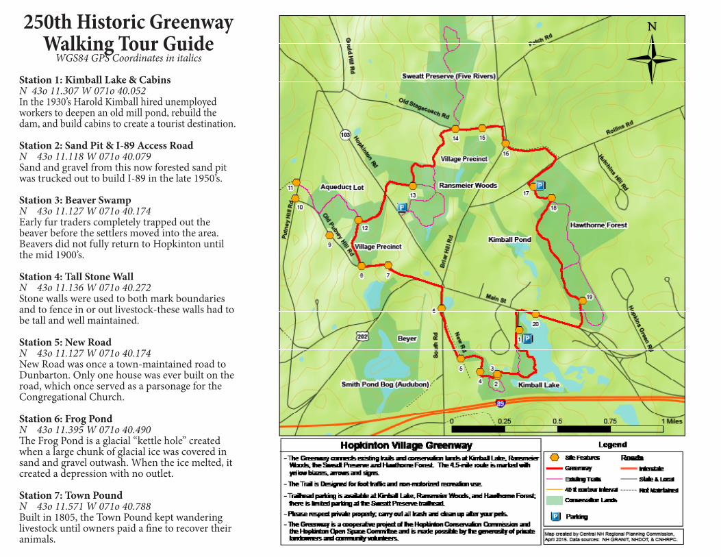
Station 8: Hopkinton AqueductN 43o 11.570 W 071o 40.940The Hopkinton Aqueduct Association, formed in 1840, supplied water to Hopkinton Village from hand dug wells and wooden pipes.
Station 9: Indian RaidN 43o 11.696 W 071o 41.117In 1753, Abraham Kimball and Samuel Putney were captured here by Indians. They laterescaped from their captors in Boscawen.
Station 10: Site of Putney GarrisonN 43o 11.846 W 071o 41.311Built in 1744 in the geographical center of Hopkinton, this was one of three garrison houses built to protect residents from Indian raids during the French and Indian War.
Station 11: Site of First ParsonageN 43o 11.913 W 071o 41.304This geographic center of town was expected to become the Town Center. The Town’s first minister, Reverend James Scales, purchased this land in 1757 for a parsonage. After much debate the churches were all built in other parts of Town.
Station 12: Short Stone WallN 43o 11.759 W 071o 40.958Short walls like this were made from rocks removed from crop land and were not intended to contain livestock.
Station 13: Derek’s BrookN 43o 11.899 W 071o 40.648In 2013 this brook was named after Derek Owens, a local farmer, stone mason, and long-time Chair of the Hopkinton Conservation Commission.
Station 14: Sweatt PreserveN 43o 12.133 W 071o 40.410In 2003, the heirs of Geraldine and Robert Sweatt generously donated 73 acres of forest-land to Five Rivers Conservation Trust.
Station 15: Meadow Hearth Art ColonyN 43o 12.136 W 071o 40.259This colonial home was a renowned artists’ colony in the late 1940’s and 1950’s. A 300-seat theater was located behind the house.
Station 16: Graves RoadN 43o 12.071 W 071o 40.126This was the original route to Beech Hill from before the lower end of Rollins Road was built.
Station 17: Hopkinton Village DumpN 43o 11.895 W 071o 39.974This site was used as the Hopkinton Village dump from the late 1800’s to the mid 1900’s.
Station 18: Rachael’s BrookN 43o 11.848 W 071o 39.871Named in honor of Rachael Johnson whose do-nation allowed the Town to acquire her ancestral property, now called Hawthorne Forest.
Station 19: Ancient Pine TreeN 43o 11.426 W 071o 39.695In the 1930’s, most of the white pines that grew in abandoned pastures were clear-cut by Rachel Johnson’s father, but this white pine was left un-cut due to its poor shape and quality.
Station 20: Grist Mill SiteN 43o 11.372 W 071o 39.958The Town’s first corn grist mill was built at this site in 1765. Local water-powered mills helped colonial Hopkinton remain almost totally self-sufficient for its food and industrial needs.
For more info, visit:www.hopkintonconservationland.org
Hopkinton Village Greenway250th Anniversary
Historic Walking Guide
Photos courtesy of the Hopkinton Historical Society
250th Historic Greenway Walking Tour Guide
WGS84 GPS Coordinates in italics
Station 1: Kimball Lake & CabinsN 43o 11.307 W 071o 40.052In the 1930’s Harold Kimball hired unemployed workers to deepen an old mill pond, rebuild the dam, and build cabins to create a tourist destination.
Station 2: Sand Pit & I-89 Access RoadN 43o 11.118 W 071o 40.079Sand and gravel from this now forested sand pit was trucked out to build I-89 in the late 1950’s.
Station 3: Beaver SwampN 43o 11.127 W 071o 40.174Early fur traders completely trapped out the beaver before the settlers moved into the area. Beavers did not fully return to Hopkinton until the mid 1900’s.
Station 4: Tall Stone WallN 43o 11.136 W 071o 40.272Stone walls were used to both mark boundaries and to fence in or out livestock-these walls had to be tall and well maintained.
Station 5: New RoadN 43o 11.127 W 071o 40.174New Road was once a town-maintained road to Dunbarton. Only one house was ever built on the road, which once served as a parsonage for the Congregational Church.
Station 6: Frog PondN 43o 11.395 W 071o 40.490The Frog Pond is a glacial “kettle hole” created when a large chunk of glacial ice was covered in sand and gravel outwash. When the ice melted, it created a depression with no outlet.
Station 7: Town PoundN 43o 11.571 W 071o 40.788Built in 1805, the Town Pound kept wandering livestock until owners paid a fine to recover their animals.