Embed Size (px)
Citation preview
Poster Presentations 586 ICOET 2005 Proceedings On the Road to Stewardship 587 Poster Presentations
HIGHWAY CROSSING STRUCTURES FOR METROPOLITAN PORTLAND’S WILDLIFE
Linda K. Anderson (Phone: 503-725-4800, Email: [email protected]), Department of Geography, Portland State University, P.O. Box 751, Portland, OR 97207, Fax: 503-725-5585
Abstract
The protection and restoration of the Portland, Oregon metropolitan region’s wildlife biodiversity is an overarching objective of Metro Parks and Greenspaces. Metro, Portland’s elected regional government, currently manages 8,000 acres of open space containing 50 mammal species. Included are roughly 50 miles of stream and river frontage as well as wetlands, riparian areas, meadows, forests, and other valuable habitat. Metro, the U.S. Fish and Wildlife Agency, and Portland State University have embarked on a jointly funded project to promote biodiversity by encouraging the use of wildlife-crossing structures to reestablish wildlife-movement corridors within areas currently fragmented by roads.
This team project has three sequential stages. Stages 1 and 2 have been completed. Stage 3 is currently underway:
Stage 1. Examination of the extent of the deer-vehicle conflict problem in the Portland metropolitan region and identification of deer-vehicle accident (DVA) hotspots for potential crossing-structure construction. The black-tailed deer (Odocoileus hemionus Columbianus) is the resident subspecies.1
Stage 2. Production of a user-friendly manual that can be employed by transportation planners to incorporate wildlife-crossing structures into the region’s transportation-planning process.2
Stage 3. Development of a model that predicts DVA hotspots to facilitate the intelligent siting and design of future roads in the region. While the literature contains accounts of model development for predicting DVA hotspots for the white-tailed deer (Odocoileus hemionus), there appear to be no studies (to date) for predicting DVA hotspots for the black-tailed deer.3
In stage 1, we collected a total of 2,200 DVA incidents in Clackamas, Multnomah, and Washington Counties for the period 1987-2002 from road-maintenance department carcass pickup reports, Oregon Department of Transportation (ODOT) wildlife-vehicle accident reports, and wildlife-rehabilitator intake records. Because ODOT does not maintain deer carcass pickup records for state and federal highways, the most complete data available were for county-maintained roads. Incidents were geocoded and mapped. A GIS analysis, using grid cells of 1.00mi2 and 0.25 mi2, regressed total DVAs/cell against a suite of landscape characteristics/cell: 1) total new building permits, 2) total miles of streams and rivers, 3) total miles of roads and highways, 4) total forest vegetation, 5) total other vegetation, and 6) total wetland area. DVA hotspots were identified visually.
We determined that DVAs were nonrandomly located along roads and that they began to increase in June and peak in November. No significant correlation was established between DVA density and any of the landscape variables.
Metro is currently pursuing development of crossing structures at several of the sites identified by the data as hot-spots. Students in Portland State University’s Master of Urban and Regional Planning program used the results of stage 1 to produce the Metro publication “Wildlife Crossings: Rethinking Road Design to Improve Safety and Reconnect Habitat.” This is a comprehensive manual for siting, designing, and funding wildlife-crossing structures in the urban/suburban/rural mix of metropolitan Portland. It is designed for transportation planners and resource agencies and is available to the general public.
In stage 3, a temporal and spatial DVA hotspot model for the black-tailed deer is under development for northwest Clackamas County using additional years of wildlife-vehicle accident reports and carcass-pickup data.
As a result of this study, we recommend that all road-maintenance agencies maintain carcass-pickup records, includ-ing carcass-pickup locations identified by GPS, date of retrieval, species, gender, and age class. This information should be consolidated in a regional database to identify wildlife-movement corridors and substantiate the need for wildlife-crossing structures at selected locations.1Team: Jennifer Budhabhatti, Metro Parks and Green Spaces; Jo Price, Metro Data Resource Center; Luis Ruedas and Linda Anderson, Portland State University. 2Team: Masters in Urban and Regional Planning students Theresa Carr, Radcliffe Dacanay, Kevin Drake, Charl Everson, Arianne Sperry, and Kerri Sullivan, supervised by professors Connie Ozawa, Deborah Howe, and Steve Johnson of Portland State University; Jennifer Budhabhatti, Metro parks and Green Spaces; and Ted Leybold, Metro Transportation Department. 3Team: Linda Anderson, M.S. candidate, and committee members Keith Hadley, Joseph Poracsky, Heejun Chang, Geography Department; Alan Yeakley, Environmental Sciences and Resources, Portland State University.
Biographical Sketch: Linda Anderson is a M.S. candidate in geography at Portland State University, Portland, Oregon. Her master’s thesis, “An Examination of Black-tailed Deer (Odocoileus hemionus columbianus) Deer-Vehicle Accident Hotspots in Northwest Clackamas County, Oregon,” will be completed in December 2005. Fields of interest include wildlife ecology, biogeography, landscape ecology, and conserva-tion biology. She strongly believes that the conservation of wildlife-movement corridors and habitat should be standard practice in the design of transportation networks.

Poster Presentations 588 ICOET 2005 Proceedings On the Road to Stewardship 589 Poster Presentations
HOW TO TEACH A MULE DEER TO SAFELY CROSS AN INTERSTATE? PRELIMINARY RESULTS OF A WILDLIFE MORTALITY MITIGATION STRATEGY ON INTERSTATE 15 IN UTAH, USA
Silvia Rosa (Phone: 435-770-8216, Email: [email protected]) and John A. Bissonette (Phone: 435-797-2511, Email: [email protected]), USGS Utah Coop. Fish and Wildlife Research Unit, College of Natural Resources, Utah State University, Logan, UT 84322-5290
Abstract
This poster presents the preliminary results of an on-going study in Utah. Previously, high wildlife mortality registered in a 20-mile stretch of Interstate15 south of its confluence with Interstate 70 led to the establishment of a mitigation strategy focused on mule deer. The strategy focused on two major objectives: 1) decrease wildlife-vehicle crashes and 2) maintain and improve landscape permeability that facilitates wildlife movement across the highway. The mitigation put in place involved the construction of exclusion fencing, right-of-way escape ramps, and two underpasses designed primarily for large-mammal passage.
In this study, we assessed the effectiveness of the mitigation measures in reducing mule deer mortality and evalu-ated the success of the new underpasses in allowing wildlife to cross the road safely. In this poster, we compare the pre- and post-construction levels of road mortality. We also report observed problems with the mitigation structures as well as the solutions we used to solve them. We used remotely sensed cameras to record deer passage through the new underpasses during the Fall 2004 and Spring 2005 migrations and compare results with a 20-year old ‘control’ structure.
Early results showed a sporadic and lower use of the new underpasses. We suspect that the novel presence of the new crossing structures, coupled with historic learned-behavioral migration patterns, may be responsible for these early results. The number of animals that used the new structures, however, leaves optimistic expectations for increased use in the future. We will test the prediction of increased use during the Fall 2005 and Spring 2006 migrations.
In this poster, we also address the use of bait to encourage passage, and report on the occurrence of startle behavior in response to heavy traffic, suggesting that it may be fruitful to explore the effects of noise and the visual barriers to encourage underpass passage by wildlife.
Biographical Sketches: Silvia Rosa is currently a graduate student at Utah State University working with John Bissonette. Her work aims to assess the effectiveness of a mitigation strategy planned to reduce wildlife mortality in roads and to look at road effects on small-mammal communities in sagebrush habitats.John Bissonette is leader of the USGS Utah Cooperative Fish and Wildlife Research Unit and professor in the Department of Forest, Range, and Wildlife Sciences at Utah State University. He is currently leading a team of scientists on an NCHRP project funded by the National Academy of Sciences that is investigating the current status of wildlife crossings in North America. Bissonette is the author of four books and is currently working on a fifth book that is exploring the temporal effects of resource timing on animal response. His web sites are: http://www.cnr.usu/faculty/jbissonette/index.htm and http://www.wildlifeandroads.org.
Poster Presentations 588 ICOET 2005 Proceedings On the Road to Stewardship 589 Poster Presentations
INFERRING WHITE-TAILED DEER (ODOCOILEUS VIRGINIANUS) POPULATION DYNAMICS FROM WILDLIFE COLLISIONS IN THE CITY OF OTTAWA
Kerri Widenmaier (Phone: 613-355-1254, Email: [email protected]), Geomatics and Landscape Ecology Laboratory, Carleton University, 84A Fulton Ave., Ottawa, ON K1S 4Y8, Canada
Lenore Fahrig (Phone: 613-520-2600, ext. 3856, Email: [email protected]), Professor of Biology, Department of Biology, Carleton University, 1125 Colonel By Drive, Ottawa, ON K1S 5B6, Canada, Fax: 613-520-3569
Abstract: Concerns associated with growing white-tailed deer (Odocoileus virginianus) numbers in Ottawa, Ontario have motivated several studies related to the distribution and ecology of deer in the Ottawa-Carleton region. This project infers deer-population trends from deer-vehicle collisions in Ottawa, Ontario, and considers the influence of traffic volume on estimates of population dynamics from deer-vehicle collision data. Traffic volume and collision data for various road segments across suburban Ottawa were analyzed to answer questions related to the characteristics and spatial distribution of deer collisions and traffic volume in the city.Deer-vehicle collisions are increasing at a faster rate than traffic volume, suggesting that the deer population is increasing. The distribution of collisions supports the boundaries previously suggested for the location of one deer-herd summer range, but not the other. Deer-collision numbers east and west of the Rideau River, a likely barrier to deer movement, were very similar, even though research and concern related to deer numbers has been concentrated west of the Rideau. More collisions occurred on 400-series highways than on other roads, suggesting that highways are a higher risk for deer collisions than other roads. The number of deer-vehicle collisions is much higher on recently constructed 400-series highways than on older 400-series highways, indicating that new highways represent high-risk areas for collisions.This research suggests that deer-vehicle collisions could be a very useful data source for inferring deer population dynamics of suburban deer, but it is imperative that significant factors affecting the number and distribution of collisions, such as category of road and traffic volume, are considered during any analyses.
Introduction
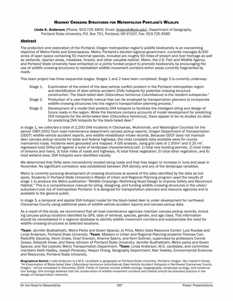
White-tailed deer (Odocoileus virginianus) in the City of Ottawa have become a substantial source of complaints in recent years (Broadfoot and Voigt 2000). Concern for human and deer safety has escalated in consideration of recent increases in deer-vehicle collisions (NCC draft; Broadfoot and Voigt 2000). Deer browsing has caused much damage to cash crops (Broadfoot and Voigt 2000) and damage to natural vegetation in the Ottawa area may be causing structural changes to ecosystems (Carr and Koh 2002). In response to mounting complaints, the National Capital Commission has established a Deer Management Committee for the purpose of developing a management strategy to address concerns associated with increasing deer abundance (NCC draft). This committee is comprised of staff members from the City of Ottawa, National Capital Commission, Department of National Defense, Ontario Ministry of Natural Resources, Ontario Ministry of Agriculture, and the Ministry of Transportation of Ontario (NCC draft). The strategy is being developed to maintain sustainable deer populations in Ottawa’s rural landscape (NCC draft). A large portion of this strategy concerns the Ottawa Greenbelt, which is a large area of public land originally established to control urban sprawl, protect local agriculture, and ensure long-term supply of land for future needs (figure 1) (Palermo 1993).
Figure 1. The Rideau River and the Ottawa Greenbelt within the City of Ottawa.

Poster Presentations 590 ICOET 2005 Proceedings On the Road to Stewardship 591 Poster Presentations
Since it is time consuming and costly to determine exact deer numbers directly, deer-vehicle collision data have been used to estimate population trends in Ottawa over the last decade (Broadfoot and Voigt 2000). Although collision data are not the only indicator available for deer population changes, their accessibility and spatial specificity give them important potential for use in deer monitoring and management. This project infers deer-population trends from deer-vehicle collisions in Ottawa, Ontario, and considers the influence of traffic volume on estimates of population dynamics from deer-vehicle collision data.
An increasing trend in deer-vehicle collision numbers does not necessarily indicate an increasing deer population. Previous studies have shown traffic volume to be an important contributing factor to deer-collision numbers (McCaffey 1973; Allen and McCullough 1976). Therefore, the first question asked in this study is: Is the increasing trend in deer-vehicle collisions in The City of Ottawa due to an increase in the size of the deer population or could it be simply a reflection of an increasing trend in traffic volume? If the deer population in Ottawa is increasing, I expect to see a greater rate of increase of deer-vehicle collisions than traffic volume.
Broadfoot and Voigt (2000) identified three major areas of high deer density in the Ottawa area and delineated the summer- and winter-range boundaries associated with these proposed herds. While winter-range size and extent was determined according to deer-browsing studies, the shapes of summer ranges were inferred from the general movement behavior of Ontario deer and the location of likely barriers to deer movement (Broadfoot and Voigt 2000). Knowledge of deer-herd locations is important in any deer management plan (Porter et al. 2004; Van Deleen et al. 1998; Grund et al. 2002). The second question addressed in this research is: Does the spatial distribution of deer-vehicle collisions corroborate the deer-herd locations proposed by Broadfoot and Voigt (2000)?
The City of Ottawa is bisected by the Rideau River (figure 1), with a typical width of 150 to 200 m, and likely presents a barrier to deer movement. A large portion of the research related to white-tailed deer in the City of Ottawa has been focused to the west of the Rideau River (NCC draft; Broadfoot and Voigt 2000; Campbell 2002; Carr and Koh 2002), while little research has been conducted east of the Rideau River (Carr and Koh 2002). This may be because areas of high deer densities west of the river are located in close proximity to suburban areas, which results in a higher rate of deer-human conflict west of the Rideau. The impression that the deer population is increasing west of the Rideau River has recently led to an extension of the deer-hunting season in this part of the region (OMNR 2003). The third question is: Do deer-vehicle collision trends reflect a larger deer population west of the Rideau River than east of the Rideau?
My two final questions relate to deer behavior with respect to roads. Allen and McCullough (1976) found deer-collision numbers to increase with increasing traffic speed to a maximum of 95 km/h and then to decline dramatically, suggest-ing that deer may avoid roads with high-speed traffic. To test this I asked: Do 400-series highways experience a lower deer-vehicle collision rate, indicating that deer avoid high-speed traffic?
It is possible that white-tailed deer become accustomed to the location and perceived risk associated with the loca-tion, of roads over time. Avoidance of roads by deer has been observed previously (Rost and Bailey 1979); therefore the number of collisions on a road should decrease over time as deer learn to avoid a particular road. The last question asked will be: Do recently constructed 400-series highway segments experience more deer-vehicle collisions than older 400-series highway segments? The results of this question could indicate that deer learn to avoid roads over time.
Materials and Methods
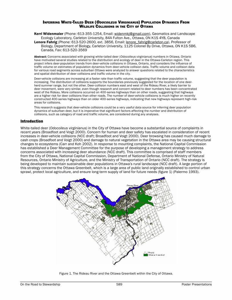
Traffic-volume dataTraffic-volume data for municipal and regional intersections within Ottawa were obtained from the City of Ottawa for the years 1995 to 2004. Traffic counts are conducted by the City of Ottawa between May and August for an unfixed number of hours within a day for various intersections throughout the city. All traffic counts available for segments about the city’s perimeter were collected. Traffic counts for a specific intersection were only used in an analysis if they were available in the form of an 8-hour total taken on a weekday and at least five years data were present within the time period considered in each question (table 1). Traffic-volume data were not always available for consecutive years for a road segment, necessitating the interpolation of traffic volume numbers for some years for some segments. This meant that the five years of volume data had to include both the first and last years considered in the specific question in order for traffic-volume values to be interpolated.
Traffic-volume data from the City of Ottawa were converted from a per-intersection basis to a per-segment basis. This was done in one of two ways: a) by combining the values of traffic counts of adjacent intersections for vehicles directed towards a common road segment (figure 2) or b) by combining the subtotals from the same intersection for traffic coming from and heading towards a common road segment (figure 3). Traffic-volume data for provincial and 400-series highways of interest within the City of Ottawa were purchased from Ronen Publishing House, Inc. These included Highway 7, Highway 417 (Queensway), and Highway 416 (Veteran’s Memorial Highway). These traffic counts were available per segment ,and covered varying time periods depending on the completion of construction of the highway/highway segment. The values were provided as 24-hour totals and were divided by three so that they could be analyzed with the 8-hour totals provided by the City of Ottawa. Since traffic volume is greatest during the day, these 8-hour totals likely underestimate the 8-hour total daily traffic volume on the highways.
Poster Presentations 590 ICOET 2005 Proceedings On the Road to Stewardship 591 Poster Presentations
Figure 2. Determining traffic volume of a segment using two adjacent intersections. The total traffic volume for this segment was determined by combining the number of cars in positions 1A, 1B, and 1C with positions 2A,
2B, and 2C.
Figure 3. Determining traffic volume of a segment using one intersection. The total traffic volume for this segment was determined by combining the number of cars in position 1A with positions 2A, 2B, and 2C.
Table 1. Response variables and time periods considered in each question

Poster Presentations 592 ICOET 2005 Proceedings On the Road to Stewardship 593 Poster Presentations
Deer-vehicle collision dataDeer-collision data were collected from the City of Ottawa for the years 1995 to 2003. These data included all deer-vehicle collisions reported to the Ottawa Police during this time period. In my analysis, I only included deer-vehicle collisions that took place between intersections on road segments for which I had traffic-volume data (see previous section). Collisions that took place in an intersection were not included in analyses, as it was impossible to assign them to a specific road segment.
GIS databaseAll traffic volume and deer-collision data were compiled into a Geographic Information System using ArcView 3.2. Deer-vehicle collision data and traffic-volume data were assigned to the location of the road segment and the year of interest. The length of each provincial, municipal, and regional segment used in the analyses was determined using the ReturnLength function available in ArcView 3.2.
Data Comparison and Statistical Analysis
The set of road segments used in this study were the segments for which traffic-volume data were available. Collision and traffic-volume data were compared in various ways to answer the questions addressed in this study. When deer-vehicle collisions were used as an indicator of relative deer-population size (relative-population index), the response variable was the number of deer-vehicle collisions per car per meter to correct for both traffic volume and segment length. This was also the response variable used to compare collision frequencies of different categories of roads. Rates of increase of traffic volume and deer-vehicle collisions were determined using standardized collision and traffic-volume index values. The collision frequency for a particular area was the number of collisions that year divided by the number of collisions in the first year in the time period, while the traffic-volume index was the traffic volume per meter divided by the traffic volume/m in the first year in the time period.
1. Is the increasing trend in deer-vehicle collisions in the City of Ottawa due to an increase in the size of the deer population or could it be simply a reflection of an increasing trend in traffic volume?To determine whether collision trends are simply a reflection of traffic-volume trends, rates of change in deer traffic casualties and traffic volume in suburban and rural Ottawa were compared for 1995 to 2002. The traffic-volume index value for each year was determined using the following equation:
Σ (v/l1…v/li)
Where v/l1 is the 8-hour total traffic volume of a segment divided by its length in meters and i represents the total number of segments in the focus area. The deer-vehicle collision index value for each year was defined as the total number of reported deer collisions during that year within the focus area. The deer-vehicle collision values were standardized to the 1995 index value. The traffic-volume values were standardized to the 1995 traffic-volume value. The standardized collision and traffic-volume values were then plotted against time to compare their trends. If the rate of increase of deer-vehicle collisions is noticeably greater than that of the traffic volume, then the deer population in Ottawa is likely increasing. If not, then the deer-vehicle collision trends could simply be a reflection of growing traffic volume. Some highway segments were excluded from this comparison, as traffic-volume data were not available for Highway 416 and two segments of Highway 417 for the years 1995 and 1996.
2. Does the spatial distribution of deer-vehicle collisions corroborate the deer-herd locations proposed by Broadfoot and Voigt (2000)?The deer-vehicle collisions within two proposed summer ranges were compared against each other and against segments outside both ranges for the years 1997 to 2002. The South March and Stony Swamp summer ranges were considered in the analysis, but the Hardwood Plains summer range was not included because traffic-volume data were not available for segments in this area. A segment was deemed to be within a summer range if its center was contained within the boundaries proposed by Broadfoot and Voigt (2000). The relative-population indices (collisions/car/m) for the South March and Stony Swamp summer ranges and the relative-population index of segments outside of both summer ranges were plotted against year (1997-2002). For the distribution of collisions to support the summer-range locations, I would expect to see greater population indices within the ranges than without.
Furthermore, the relative-population index of the Stony Swamp summer range should be greater than that of the South March summer range, since Stony Swamp was estimated to contain a higher deer density (Broadfoot and Voigt 2000). T-tests were used to determine if the summer-range population indices were significantly different from each other and from segments outside both ranges. Traffic volume per meter within and outside the summer ranges was also plotted, as was the standardized traffic volume in these areas, for comparison.
3. Do deer-vehicle collision trends reflect a larger deer population west of the Rideau River than east of the river?To determine if the distribution of deer collisions reflects a greater deer abundance west of the Rideau River, the relative-population index west of the Rideau River and the relative-population index east of the river were plotted against year (1997 to 2002). A t-test was used to determine if the difference in collisions per car per meter oneither side of the river was significant. Traffic volume per meter east and west of the Rideau was also plotted for comparison purposes.

Poster Presentations 592 ICOET 2005 Proceedings On the Road to Stewardship 593 Poster Presentations
Deer-harvest data was available from the Ontario Ministry of Natural Resources for the years 1999 to 2002 for Wildlife Management Units (WMUs) in Ontario. In order to compare deer-harvest trends with deer-vehicle collision trends east and west of the Rideau River, the number of deer harvested in WMU 65 and 64B, located east and west of the river respectively (figure 4), were plotted against year.
Figure 4. Wildlife Management Units 64B and 65 (OMNR 2003).
4. Do 400-series highways experience fewer deer-vehicle collisions than other segments, indicating that deer avoid high-speed traffic?The collision frequency (collisions/car/m) on highway segments and the collision frequency for other segment types were plotted against year (1997 to 2002). All segments included were located west of the Rideau River to avoid any discrepancies due to the small sample size east of the river. Recently constructed 400-series highway segments were not included in the comparison so as to avoid their possible influence on the number of collisions/car/m (see question 5). A t-test was used to determine whether the difference in collision frequency for highways and other roads was significant. Traffic volume per meter on highways and other category roads was also plotted for comparison.
5. Do recently constructed 400-series highway segments experience more deer-vehicle collisions than older 400-series highway segments?The collision frequency for recently constructed 400-series highway segments (since 1995) and for older 400-series highway segments were plotted against year (1997 to 2002). New segments included Highway 416 and the Panmure and March sections of Highway 417. All segments included were located west of the Rideau River. Only highway segments were considered in this analysis to eliminate any differences in collisions due to the speed of traffic or the category of road. A t-test was used to determine whether the collision-frequency index of newer highways was significantly different from that of older highways. Traffic volume per meter on recently constructed highways and older highways was also plotted for comparison.
Results
1. Is the increasing trend in deer-vehicle collisions in the City of Ottawa due to an increase in the size of the deer population or could it be simply a reflection of an increasing trend in traffic volume?Figure 5 shows the distribution of segments used to compare rates of increase of traffic volume and deer-vehicle colli-sions in Ottawa. Deer-vehicle collisions are increasing at a greater rate than the traffic volume (figure 6). Therefore, the increasing trend in deer-vehicle collisions is not simply a reflection of an increasing trend in traffic volume.

Poster Presentations 594 ICOET 2005 Proceedings On the Road to Stewardship 595 Poster Presentations
Figure 5. Spatial distribution of road segments included in question 1.
Figure 6. Traffic volume and deer-vehicle collisions from 1995 to 2002, standardized to their 1995 values.
2. Does the spatial distribution of deer-vehicle collisions corroborate the deer-herd locations proposed by Broadfoot and Voigt (2000)?Figure 7 shows the boundaries of the Stony Swamp and South March summer ranges as identified by Broadfoot and Voigt (2000), as well as the road segments considered to be within and outside of these ranges. Segments within South March returned the largest relative-population index for the entire time period (figure 8), although traffic volume in this area was similar to the Stony Swamp area (figure 9). The relative-population index for the South March range was significantly greater than the relative-population index for segments outside both ranges (T = 4.84, p = 0.01, df = 5) and for the Stony Swamp range (T = 11.1, p < 0.00, df = 5). Collisions/car/m w/car within the Stony Swamp summer range were not significantly different from those outside both ranges (T = 2.44, p = 0.06, df = 5).
The distribution of deer-vehicle collisions supports the boundaries proposed by Broadfoot and Voigt (2000) for the South March summer range, but not the Stony Swamp summer range. The relative-population index for segments outside both ranges is increasing, while the populations within the ranges appear to be stable (figure 10).

Poster Presentations 594 ICOET 2005 Proceedings On the Road to Stewardship 595 Poster Presentations
Figure 7. Spatial distribution of road segments included in question 2 and locations of the Stony Swamp and South March Deer Herd summer ranges.
Figure 8. Deer collisions/car/m within the proposed summer ranges of the Stony Swamp and South March deer herds and collisions outside of these ranges.
Figure 9. Traffic volume/m (8-hour total) within and outside of the Stony Swamp and South March summer ranges.
Poster Presentations 596 ICOET 2005 Proceedings On the Road to Stewardship 597 Poster Presentations
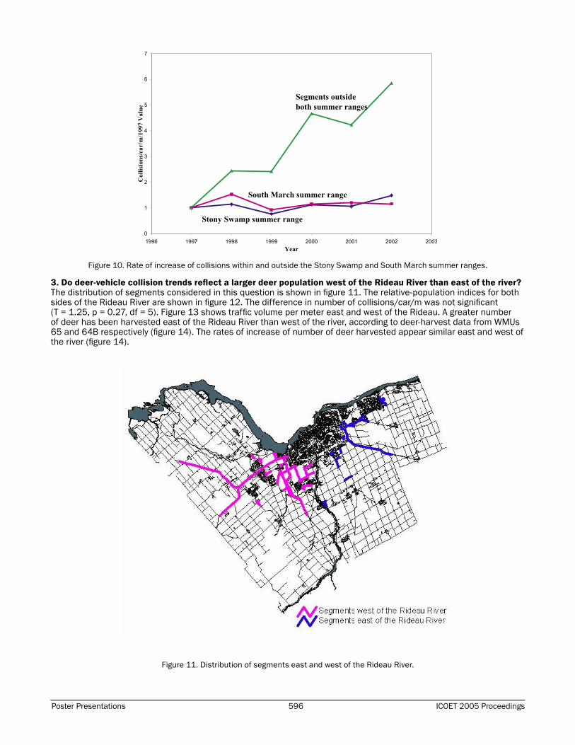
Figure 10. Rate of increase of collisions within and outside the Stony Swamp and South March summer ranges.
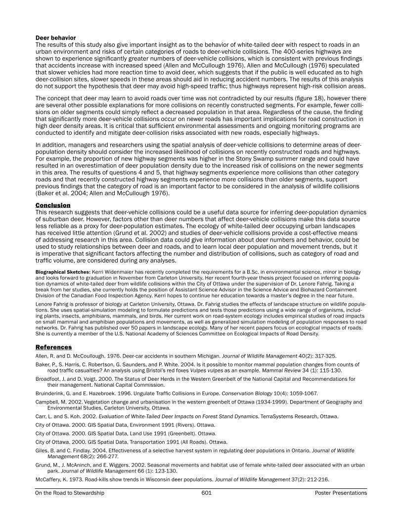
3. Do deer-vehicle collision trends reflect a larger deer population west of the Rideau River than east of the river?The distribution of segments considered in this question is shown in figure 11. The relative-population indices for both sides of the Rideau River are shown in figure 12. The difference in number of collisions/car/m was not significant (T = 1.25, p = 0.27, df = 5). Figure 13 shows traffic volume per meter east and west of the Rideau. A greater number of deer has been harvested east of the Rideau River than west of the river, according to deer-harvest data from WMUs 65 and 64B respectively (figure 14). The rates of increase of number of deer harvested appear similar east and west of the river (figure 14).
Figure 11. Distribution of segments east and west of the Rideau River.

Poster Presentations 596 ICOET 2005 Proceedings On the Road to Stewardship 597 Poster Presentations
Figure 12. Deer collisions/car/m west and east of the Rideau River.
Figure 13. Traffic volume/m (8-hour total) west and east of the Rideau River.
Figure 14. Deer-harvest data from Wildlife Management Units 64A and 65, respectively.

Poster Presentations 598 ICOET 2005 Proceedings On the Road to Stewardship 599 Poster Presentations
4. Do 400-series highway segments experience fewer deer collisions than other segments, indicating that deer may avoid high-speed segments?The collision frequencies for 400-series segments and other segments are shown in figure 15. The 400-series highway segments do not experience fewer deer-vehicle collisions/car/m than other segments. Significantly more collisions actually take place on highway segments (T = 10.3, p < 0.00, df = 5). Average traffic volume for highway and other segments is shown in figure 16.
Figure 15. Collisions/car/m on highway and other segments.
Figure 16. Traffic volume/m (8-hour total) on highway and other segments.
5. Do recently constructed 400-series highway segments experience greater numbers of deer-vehicle collisions than older 400-series highway segments?Significantly more deer-vehicle collisions/car/m occurred on newer highway segments than older highway segments (T = 5.31, p < 0.00, df = 5) (figure 17). Average traffic volume on newer segments was much lower than on older segments (figure 18).

Poster Presentations 598 ICOET 2005 Proceedings On the Road to Stewardship 599 Poster Presentations
Figure 17. Collisions/car/m on recently constructed (since 1995) and older highway segments.
Figure 18. Traffic volume/m (8-hour total) on recently constructed (since 1995) and older highway segments.
Discussion
Deer in the City of OttawaThe results of this study suggest that the deer population in and around the City of Ottawa is increasing. The rate of increase of deer-vehicle collisions is greater than the rate of increase of traffic volume on the same road segments. In theory, the two most significant factors contributing to numbers of deer-vehicle collisions should be the number of cars and the number of deer on a road segment. If traffic volume was the controlling factor in observed long-term changes of deer collisions in Ottawa, then the rate of increase of collisions should be similar to the rate of increase of cars per meter. Since this was not observed (figure 6), the deer population is likely increasing. A correlation between wildlife collisions and the corresponding species population has not been universally accepted, however. McCaffery (1973) found road kills adjusted for changes in traffic volume provided an acceptable relative-population index for white-tailed deer. Baker et al. (2004) found a significant relationship between fox density and road traffic casualties.
In contrast, in a review of ungulate traffic collisions in Europe, Groot Bruinderink and Hazebroek (1996) concluded that the effects of traffic volume or ungulate population trends on road-casualty numbers are often ambiguous.
A number of factors could have contributed to a rise in numbers of deer in the Ottawa area. Vegetation changes resulting from farmland abandonment and reforestation have led to increased areas of young forests and shrubs, which provide ideal deer habitat (Broadfoot and Voigt 2000). A steady loss of light vegetation (farmland, grasses) to dense vegetation (coniferous and deciduous forest, swampy forest) has taken place from 1955 to 1999 throughout

Poster Presentations 600 ICOET 2005 Proceedings On the Road to Stewardship 601 Poster Presentations
western Ottawa (Campbell 2002), and was likely mirrored east of the Rideau River. Recent mild winters with little snow accumulation may have allowed more deer to survive to the spring (Broadfoot and Voigt 2000). Rural properties do not allow hunting provide reserves for deer, as does the Ottawa Greenbelt (figure 1) (Broadfoot and Voigt 2000).
In the late 1970’s, deer numbers were perceived to be low and, consequently, the selective-harvest system imple-mented by the Ontario Ministry of Natural Resources was initially restricted to allow deer populations to increase (Giles and Findlay 2004). Furthermore, the loss of natural predators in suburban Ottawa (NCC draft) could have contributed to deer-population growth within and around the City of Ottawa.
Figure 12 suggests that the deer population density west and east of the Rideau River is relatively similar. Considering the similar number of collisions/car/m on both sides of the river, it is possible that the Rideau River does not represent a significant population barrier to white-tailed deer in Ottawa. Deer movement across the Rideau River would have important management implications, as deer movement patterns are important to the successful management of white-tailed deer (Van Deelen et al. 1998; Porter et al. 2004; Oyer and Porter 2004; Grund et al. 2002).
The situation surrounding deer in the Ottawa area has been researched in much greater detail west of the Rideau River than east of the river (Broadfoot and Voigt 2000; NCC, draft; Campbell 2002; Carr and Koh 2002). This is likely because deer are in closer proximity to areas of suburban development on the west side of the river and because escalating complaints related to deer have necessitated intervention by the National Capital Commission and the City of Ottawa. Equivalent numbers of adverse deer-human interactions have not occurred on the east side of the river and, consequently, less research has been conducted in this area, even though deer density appears similar.
In addition, the rate of increase in the number of deer harvested on either side of the river appears similar (figure 14). Figure 14 shows a greater number of deer to be harvested in WMU 65 than 64B; this is likely because WMU 65 encom-passes a larger area (figure 4). The relationship between proximity to suburban areas and perceived deer-human conflict indicates that human-population density is also an important contributor to problems associated with deer abundance.
Deer herds west of the Rideau RiverThe spatial distribution of collisions supported the summer-range boundaries of the South March deer herd delineated by Broadfoot and Voigt (2000), but not the Stony Swamp herd (figure 8). The summer-range boundaries were based on general movement trends of Ontario deer, and the location of potential barriers to deer movement within and around Ottawa (Broadfoot and Voigt 2000). The high relative-population index for the South March area is consistent with a greater estimated post-reproduction deer population in the South March summer range (190 deer) compared with the Stony Swamp summer range (100 deer) (Broadfoot and Voigt 2000).
However, Braodfoot and Voigt (2000) estimated that the South March summer range contains 2.7 deer/m2, while 4 deer/m2 reside in Stony Swamp, which is not consistent with our results. The relative-population index for Stony Swamp was not significantly greater than that outside both ranges, suggesting that the deer population density of this area may have been estimated incorrectly or that the summer-range boundaries were incorrect. The rapid increase in collisions/car/m in areas outside both summer ranges could indicate a growing deer population outside of the summer ranges or the expansion of current summer ranges. South March and Stony Swamp areas could have reached carrying capacity, while areas outside these ranges may support additional deer.
The carrying capacities of the South March and Stony Swamp summer ranges were determined according to deer-browsing studies and were then correlated with the Ontario Deer Model to estimate actual deer population and density (Broadfoot and Voigt 2000). The disagreement between our estimates and the estimates of Broadfoot and Voigt (2000) suggests that perhaps an actual deer census should be conducted prior to the commencement of any manage-ment plans in Western Ottawa that draw on deer abundance and density estimates. It is also possible that deer-vehicle collisions are a poor indicator of the spatial distribution of deer density. The spatial distribution of wildlife collision abundance has been linked previously with wildlife density across a city (Baker et al. 2004) and along a highway (Puglisi et al. 1974), but is not unanimously accepted (Groot Bruinderink and Hazebroek 1996).
Should the boundaries for the summer ranges be incorrect, this could have important management implications for Western Ottawa deer herds. As mentioned previously, knowledge of seasonal movement and migration patterns has been shown to be an important component of the successful management of urban white-tailed deer (Van Deelen et al. 1998; Porter et al. 2004; Oyer and Porter 2004; Grund et al. 2002). Immigration and emigration of deer should not be assumed to be equal in an area considered for localized management, especially when management goals are set to achieve low population densities (Porter et al. 2004). Broadfoot and Voigt (2000) acknowledged in their study of the Western Greenbelt that migration between the Hardwood Plains, Stony Swamp, and South March deer herds is highly likely.
It is important that the extent and seasonality of these migration patterns are well understood before a localized-management plan is implemented, as management programs focused during times of little movement would allow more effective control of population numbers (Grund et al. 2002).
Poster Presentations 600 ICOET 2005 Proceedings On the Road to Stewardship 601 Poster Presentations
Deer behaviorThe results of this study also give important insight as to the behavior of white-tailed deer with respect to roads in an urban environment and risks of certain categories of roads to deer-vehicle collisions. The 400-series highways are shown to experience significantly greater numbers of deer-vehicle collisions, which is consistent with previous findings that accidents increase with increased speed (Allen and McCullough 1976). Allen and McCullough (1976) speculated that slower vehicles had more reaction time to avoid deer, which suggests that if the public is well educated as to high deer-collision sites, slower speeds in these areas should aid in reducing accident numbers. The results of this analysis do not support the hypothesis that deer may avoid high-speed traffic; thus highways represent high-risk collision areas.
The concept that deer may learn to avoid roads over time was not contradicted by our results (figure 18), however there are several other possible explanations for more collisions on recently constructed segments. For example, fewer colli-sions on older segments could simply reflect a decreased population in that area. Regardless of the cause, the finding that significantly more deer-vehicle collisions occur on newer roads has important implications for road construction in high deer density areas. It is critical that sufficient environmental assessments and ongoing monitoring programs are conducted to identify and mitigate deer-collision risks associated with new roads, especially highways.
In addition, managers and researchers using the spatial analysis of deer-vehicle collisions to determine areas of deer-population density should consider the increased likelihood of collisions on recently constructed roads and highways. For example, the proportion of new highway segments was higher in the Stony Swamp summer range and could have resulted in an overestimation of deer population density due to the increased risk of collisions on the newer segments in this area. The results of questions 4 and 5, that highway segments experience more collisions than other category roads and that recently constructed highway segments experience more collisions than older segments, support previous findings that the category of road is an important factor to be considered in the analysis of wildlife collisions (Baker et al. 2004; Allen and McCullough 1976).
ConclusionThis research suggests that deer-vehicle collisions could be a useful data source for inferring deer-population dynamics of suburban deer. However, factors other than deer numbers that affect deer-vehicle collisions make this data source less reliable as a proxy for deer-population estimates. The ecology of white-tailed deer occupying urban landscapes has received little attention (Grund et al. 2002) and studies of deer-vehicle collisions provide a cost-effective means of addressing research in this area. Collision data could give information about deer numbers and behavior, could be used to study relationships between deer and roads, and to learn local deer population and movement trends, but it is imperative that significant factors affecting the number and distribution of collisions, such as category of road and traffic volume, are considered during any analyses.
Biographical Sketches: Kerri Widenmaier has recently completed the requirements for a B.Sc. in environmental science, minor in biology and looks forward to graduation in November from Carleton University. Her recent fourth-year thesis project focused on inferring popula-tion dynamics of white-tailed deer from wildlife collisions within the City of Ottawa under the supervision of Dr. Lenore Fahrig. Taking a break from her studies, she currently holds the position of Assistant Science Advisor in the Science Advice and Biohazard Containment Division of the Canadian Food Inspection Agency. Kerri hopes to continue her education towards a master’s degree in the near future.Lenore Fahrig is professor of biology at Carleton University, Ottawa. Dr. Fahrig studies the effects of landscape structure on wildlife popula-tions. She uses spatial-simulation modeling to formulate predictions and tests those predictions using a wide range of organisms, includ-ing plants, insects, amphibians, mammals, and birds. Her current work on road-system ecology includes empirical studies of road impacts on small mammal and amphibian populations and movements, as well as generalized simulation modeling of population responses to road networks. Dr. Fahrig has published over 50 papers in landscape ecology. Many of her recent papers focus on ecological impacts of roads. She is currently a member of the U.S. National Academy of Sciences Committee on Ecological Impacts of Road Density.
ReferencesAllen, R. and D. McCoullough. 1976. Deer-car accidents in southern Michigan. Journal of Wildlife Management 40(2): 317-325. Baker, P., S. Harris, C. Robertson, G. Saunders, and P. White. 2004. Is it possible to monitor mammal population changes from counts of
road traffic casualties? An analysis using Bristol’s red foxes Vulpes vulpes as an example. Mammal Review 34 (1): 115-130. Broadfoot, J. and D. Voigt. 2000. The Status of Deer Herds in the Western Greenbelt of the National Capital and Recommendations for
their management. National Capital Commission. Bruinderink, G. and E. Hazebroek. 1996. Ungulate Traffic Collisions in Europe. Conservation Biology 10(4): 1059-1067. Campbell, M. 2002. Vegetation change and urbanisation in the western greenbelt of Ottawa (1934-1999). Department of Geography and
Environmental Studies, Carleton University, Ottawa. Carr, L. and S. Koh. 2002. Evaluation of White-Tailed Deer Impacts on Forest Stand Dynamics. TerraSystems Research, Ottawa. City of Ottawa. 2000. GIS Spatial Data, Environment 1991 (Rivers). Ottawa. City of Ottawa. 2000. GIS Spatial Data, Land Use 1991 (Greenbelt). Ottawa. City of Ottawa. 2000. GIS Spatial Data, Transportation 1991 (All Roads). Ottawa. Giles, B. and C. Findlay. 2004. Effectiveness of a selective harvest system in regulating deer populations in Ontario. Journal of Wildlife
Management 68(2): 266-277. Grund, M., J. McAninch, and E. Wiggers. 2002. Seasonal movements and habitat use of female white-tailed deer associated with an urban
park. Journal of Wildlife Management 66 (1): 123-130. McCaffery, K. 1973. Road-kills show trends in Wisconsin deer populations. Journal of Wildlife Management 37(2): 212-216.

Poster Presentations 602 ICOET 2005 Proceedings On the Road to Stewardship 603 Poster Presentations
National Capital Commission (NCC). 2002. Deer and the Ecosystem. National Capital Commission. (Draft.) Ontario Ministry of Natural Resources. 2003. Ontario Deer Management Sourcebook: Companion document to Ontario Deer Management
Workbook. Kemptville, Ontario. Oyer, A. and W. Porter. 2004. Localized management of white-tailed deer in the central Adirondack Mountains, New York. Journal of Wildlife
Management 68(2): 257-265. Palmero, F. 1992. The Ottawa Greenbelt. TUNS Architecture, Halifax. Porter, W., H. Underwood, and J. Woodard. 2004. Movement behavior, dispersal, and the potential for localized management of deer in a
suburban environment. Journal of Wildlife Management 68(2): 247-256. Puglisi, M., J. Lindzey, and E. Bellis. 1974. Factors associated with highway mortality of white-tailed deer. Journal of Wildlife Management
38(4): 799-807. Rost, G. and J. Bailey. 1979. Distribution of mule deer and elk in relation to roads. Journal of Wildlife Management. 43(3): 634 – 641. Van Deelen, T., H. Campa, M. Hamaday and J. Haufler. 1998. Migration and seasonal range dynamics of deer using adjacent deeryards in
northern Michigan. Journal of Wildlife Management 62(1): 205-213.

Poster Presentations 602 ICOET 2005 Proceedings On the Road to Stewardship 603 Poster Presentations
INTEGRATED TRAINING COURSE FOR ENGINEERS AND WILDLIFE BIOLOGISTS
Sandra L. Jacobson (Phone: 707-825-2900, Email: [email protected]), Wildlife Biologist, USDA Forest Service, Pacific Southwest Research Station, Redwood Sciences Laboratory, 1700 Bayview Dr., Arcata, CA 95521, Fax: 707-825-2901
Terry Brennan (Phone: 602-225-5375, Email: [email protected]), Transportation Development Engineer, Tonto National Forest, 2324 E. McDowell Rd., Phoenix, AZ 85006
Abstract
The need for a comprehensive (yet concise) training course on the basics of highway and wildlife interactions has become more apparent as more transportation engineers and wildlife biologists are faced with demands to consider wildlife mortality and connectivity issues and to incorporate wildlife crossing structures in highway projects.
The USDA Forest Service has developed an interagency, interdisciplinary two-day training session that walks engineers and biologists through the basics of habitat connectivity, impacts to wildlife from highways, effective mitigation mea-sures, funding sources, and law and policy related to highway projects. This course, Innovative Approaches to Wildlife and Highway Interactions, has been designed to be taught by a wildlife biologist and a transportation engineer, with a target audience of mixed, mid-level professionals who are planning highway projects of various types.
The course was designed to integrate disciplines so that the challenging situations we face in highway projects can be innovatively solved and networking between agencies and disciplines is facilitated. The course is modular and based on the Wildlife Crossings Toolkit (http://www.wildlifecrossings.info), also developed by the USDA Forest Service, and current scientific works.
Eight sessions across the country have been completed since course development, with participants from eight state DOT’s, FHWA, NGO’s, state fish and wildlife agencies, FWS, and three federal resource agencies. Departments of transportation and resource agencies are welcome to host training sessions across the country with these training materials and instructors.
Funding for the course development was provided by the Coordinated Transportation Improvement Project fund, an interagency pooled fund.
Biographical Sketch: Sandra L. Jacobson, wildlife biologist/research and management liaison, Pacific Southwest Research Station, Redwood Sciences Laboratory, Arcata, California. Education: B.A. in zoology (1983), Humboldt State University, Arcata, California, and M.S. in natural resources/wildlife (1986), Humboldt State University. Jacobson has served as a wildlife biologist for the USDA Forest Service since 1980, working on three national forests at the district and forest levels in California and Idaho. She has worked for the USDI Fish and Wildlife Service, California Department of Fish and Game, and the USDA Soil Conservation Service. As the district wildlife biologist for the Bonners Ferry Ranger District on the Idaho Panhandle National Forests for 13 years, she managed grizzly bears, woodland caribou, and other threatened or endangered wildlife in an interagency and international setting. Ms. Jacobson is the lead biologist for the Wildlife Crossings Toolkit website. She is a charter member of the Transportation Research Board’s Task Force on Ecology and Transportation and a team member for NCHRP 25-27’s Evaluating the Effectiveness of Wildlife Crossing Structures. She is a member of the University of California-Davis Road Ecology Center’s Scientific Advisory Committee. Currently, Ms. Jacobson is providing project-level technical expertise and training on wildlife and highway issues for several agencies around the country while acting as a research/management liaison at the Pacific Southwest Research Station.
Poster Presentations 604 ICOET 2005 Proceedings On the Road to Stewardship 605 Poster Presentations
INTEGRATING TRANSPORTATION AND RESOURCE CONSERVATION PLANNING
Stephen Eastwood (Phone: 858-674-2969, Email: [email protected]) and Kirsten Winter (Phone: 858-674-2956, Email: [email protected]), Cleveland National Forest, San Diego, CA 92127
Abstract
The arroyo toad was federally listed as an endangered species in 1994. For the last 10 years, the Cleveland National Forest in southern California has been evaluating and mitigating the effects of roads and road crossings on this spe-cies. To date, we have closed five miles of roads within toad habitat and have constructed seven crossings to reduce or eliminate the effect of the crossings on toads.
Prior to this effort, most of the stream crossings in toad habitat were unimproved and vehicles drove directly through the stream. This caused several problems for toads:
1. While crossing the stream, vehicles would often proceed to drive up and down the stream, causing consider-able disturbance of the stream bed and increasing turbidity in the stream.
2. Vehicles would often become stuck in the stream or hit a rock while attempting to cross the stream, which could result in spillage of oil or other toxic substances into the stream.
3. Tadpoles present in the stream could be crushed by vehicles driving through the crossing.
Two different types of stream crossings were constructed to separate vehicle traffic from contact with the streams. The first type was an “Arizona” crossing, which is a raised concrete ford with culverts. This type of crossing was constructed with adjacent partially buried k-rail or fencing to ensure that vehicles stayed on the road surface. The second type of crossing was a precast concrete 93 feet span designed to accommodate a 50-year flood and to eliminate vehicles from driving 400 feet up of the stream. Our poster will illustrate these two types of crossings. Since 1999, the Cleveland National Forest has been monitoring Forest roads/road crossings after rainfall events and we have not observed any arroyo toads killed or injured by vehicle traffic.

Poster Presentations 604 ICOET 2005 Proceedings On the Road to Stewardship 605 Poster Presentations
THE INVASIVE COMMON REED (PHRAGMITES AUSTRALIS) ALONG ROADS IN QUEBEC (CANADA): A GENETIC AND BIOGEOGRAPHICAL ANALYSIS
Benjamin Lelong (Phone: 418-656-7558, Email: [email protected]), Yvon Jodoin and Claude Lavoie, Centre de recherche en aménagement et développement, and François Belzile, Département de phytologie, Université Laval, Québec, Canada, G1S 7P4
Abstract
During the last century, common reed (Phragmites australis) colonies expanded in marshes of north-eastern North America. This species is highly problematical because it has a strong impact on plant and animal diversity. In the prov-ince of Québec (Canada), the spread of common reed coincided with the expansion of the highway network from 1963 to 1984. We hypothesized that highways contributed to the spread of the common reed by creating dispersal corridors and favorable habitats for the growth of the species. To test this hypothesis, in 2003 we mapped the spatial distribu-tion of common reed colonies along all Québec’s highways (2800 km). We also sampled 260 populations to determine whether common reed found along highways is native or exotic. Furthermore, in 2004 we mapped the spatial distribu-tion of colonies along secondary roads in three large areas (485-810 km²), more specifically in regions where common reed colonies were particularly abundant. Globally, 24% of roadsides were invaded by common reed. Highest common reed densities were registered near the city of Montréal, in the south-western part of the province. In this region, the common reed formed hedges several kilometres long. The roadsides of secondary roads where also highly invaded, which suggests that the entire road network contributed to the spread of common reed. Genetic analyses indicated that 99% of common reed colonies found along highways were exotic (haplotype M from Eurasia). Only three out of 260 colonies were dominated by a North American genotype. The spread of common reed in Québec probably resulted from the introduction of an exotic genotype in the first part of the 20th century. This genotype likely benefited from the expansion of the highway network to establish new colonies in most regions of southern Québec. The maintenance of the highway network (ditch digging, roadside mowing) also probably contributed to the spread of common reed and to the improvement of growth conditions for the species.
Biographical Sketch: Benjamin Lelong is a biologist and received his masters of environmental biosciences degree at Université Aix-Marseille 3 (France), where he studied the allelopathic potential of Pinus halepensis in secondary succession on abandoned agricultural land. He is presently a Ph.D. student and his major research interest is biological invasions.

Poster Presentations 606 ICOET 2005 Proceedings On the Road to Stewardship 607 Poster Presentations
LANDSCAPE ECOLOGY IN TRANSPORTATION PLANNING
Patricia L. McQueary (Phone: 360-570-6645, Email: [email protected]), Biology Program Coordinator, Washington State Department of Transportation, South Central Region, Point Plaza, P.O. Box 47332, 6639 Capital Blvd., Tumwater, WA 98501, Fax: 360-570-6633
Abstract
There has been a recent emergence of “road ecology” as a science that looks at the overall impacts of roadway systems on ecological communities in general. The evidence indicates that roadway impacts may extend beyond the operating right of way. To date, few projects have incorporated the idea of landscape ecology in the planning process.
The I-90 Snoqualmie Pass East project is breaking new ground in integrating landscape ecology and ecosystem processes into the design of a proposed expansion of the existing highway from four to six lanes for a 15-mile stretch. The project crosses/bisects an area that has been identified as the narrowest band of publicly owned land in the Washington Cascades. To better accommodate the project’s identified ecological connectivity need, the project team has focused on sites called “Connectivity Restoration Areas.” These areas have the highest likelihood of linking aquatic, riparian, and terrestrial habitat of relatively high quality north and south of the highway.
Although high-visibility wildlife (such as elk and deer) have been the major focus of most connectivity structures, there is a greater need to restore and enhance ecological processes (such as the regulation of hydrologic flows and soil retention) that often drive the ecosystem in general. This is most evident along the I-90 corridor during periods of snow-melt when water is a dominant feature on the landscape. The I-90 corridor contains numerous high-quality wetlands, some of which have been separated hydrologically by the existing highway. In some cases, the highway has created wetland areas by acting as a dike, interfering with natural-surface and subsurface flow paths. Many stream crossings have constriction points that impact the floodplain connectivity and do not allow for channel meander.
Via a collaborative, interdisciplinary process, the Washington State Department of Transportation (WSDOT), South Central Region has developed guidance for recommending a preferred alternative that will integrate the needs of aquatic, riparian, wetland, and terrestrial ecosystems and the needs of the associated organisms into the design of the new highway expansion. This incorporates not only the area adjacent to the highway and within the operating right-of-way, but expands to look at proper functioning of hydrologic processes at a broader scale. WSDOT also incorporated the work of Singleton and Lehmkuhl (2000) that identified areas of animal movement and landscape permeability within the I-90 corridor. The placement of the structures should provide opportunities for movement of organisms between populations and reduce the risks associated with demographic isolation. Increasing the permeability of the highway should also reduce direct mortality of individuals and increase the likelihood of persistence of local and regional populations that may be genetically distinct.
The desired, long-term conditions associated with the highway expansion are a functioning ecosystem with late-successional reserve forests, properly functioning streams, and wetlands that provide additional opportunities for species diversity.
Biographical Sketch: For the past seven years, I have worked as the biology program coordinator at the Washington State Department of Transportation, South Central Region. This position is responsible for compliance with the Endangered Species and Clean Water acts and includes the writing of biological assessments, wetland inventories, and wetland mitigation plans. In addition, I have been a core member of the Mitigation Development Team for the I-90 Snoqualmie Pass East Project, which has been developing strategies for wildlife and hydrological connectivity from a landscape perspective.

Poster Presentations 606 ICOET 2005 Proceedings On the Road to Stewardship 607 Poster Presentations
LEDGES TO NOWHERE—STRUCTURE TO HABITAT TRANSITIONS
Stephen D. Tonjes (Phone: 386-943-5394, Email: [email protected]), Florida Department of Transportation, Environmental Management Office, 719 S. Woodland Blvd., DeLand, FL 32720, Fax 386-736-5456
Abstract
The purpose of this poster is to call attention to problems that are being encountered in the design and construction of wildlife crossing structures that significantly undermine their usefulness to wildlife.
The problemThree roadway projects nearing completion in Florida Department of Transportation (FDOT) District 5 (east central Florida) include modifications to existing bridges and culverts that add ledges for the passage of small wildlife. In all three projects, the ledges ended abruptly at the ends of the structures, with no transition and even significant ob-stacles between the ledges and the surrounding habitat. Each of the roadway projects was designed independently by a different engineering firm, so the lack of awareness was not limited to one individual designer or firm.
(Expensive) solutionsThe design engineers for each project have produced corrected drawings. Modifications are completed or underway, except at one structure, for which the roadway contractor declined to bid on the changes. A second project to correct the problem will be needed.
RecommendationsSmall oversights during design and construction can virtually eliminate the usefulness of wildlife passages included in structures. Engineers and biologists should collaborate throughout the design process. Biologists should monitor these accommodations during and after construction.
Biographical Sketch: Stephen Tonjes has a B.S. in zoology from the University of Michigan and a M.S. in oceanography from Oregon State University. He served three years in the U.S. Coast Guard, then taught for a year at Seacamp in the Florida Keys. He worked two years managing the Coast Guard bridge permit program in Juneau, Alaska, and worked a year in the Office of Endangered Species of the U.S. Fish and Wildlife Service in Washington, D.C. Since 1986, he has worked with the Florida DOT District 5 Environmental Management Office writing and reviewing NEPA documents, applying for permits, managing mitigation contracts, coordinating commitment compliance, moving or mitigating for gopher tortoises, assessing trees, moving bats, and doing a few other things.

Poster Presentations 608 ICOET 2005 Proceedings On the Road to Stewardship 609 Poster Presentations
MONITORING OF WILDLIFE CROSSING STRUCTURES ON IRISH NATIONAL ROAD SCHEMES
Lisa Dolan (Phone: 00 353 87 95783, Email: [email protected]), Department of Zoology, Ecology and Plant Science, University College, Cork, Ireland
Abstract
Ireland is currently undergoing the largest extension to the National road network in recent years. For this reason, the number of crossing structures for wildlife on the Irish National road network has increased markedly within the last few years.
In Ireland, the structures are targeted at protected species whose habitat is directly disturbed by road construction. In general, the target species are otters (Lutra lutra) and badgers (Meles meles). However, structures have been put in place for red squirrels (Sciurus vulgaris); i.e., rope ladders linking trees on opposite sides of a motorway and the first structures for pine martens (Martes martes) and bats will be put in place in the coming year. Bat boxes and bird boxes have also been fitted on the tunnel ceilings of oversized arched culverts with mammal ledges.
Underpasses and overpasses (potential green bridges) have been constructed where farms have been bisected by new road schemes. These structures allow for the safe passage of domestic cattle over the road carriageway, but may also be utilized by wildlife, for example, red deer (Cervus elaphus) and other smaller wildlife species.
Non-target native species which can utilise these structures are: red deer (Cervus elaphus), the indigenous Irish hare (Lepus timidus hibernicus), stoat (Mustela erminea hibernica), fox (Vulpes vulpes), pygmy shrew (Sorex minutus) and field or wood mouse (Apodemus sylvaticus).
Non-native species which could potentially utilize such structures include: Sika deer (Cervus nippon), fallow deer (Cervus dama), brown hare (Lepus europaeus), rabbit (Oryctolagus cuniculus), grey squirrel (Sciurus carolinensis), hedgehog (Erinaceus europaeus), brown rat (Rattus norvegicus), house mouse (Mus (musculus) domesticus), bank vole (Clethrionomys Glareolus), feral ferret (Mustela furo), American mink (Mustela vison), and domestic cats and dogs, amongst other introduced species.
This is the first study to examine the effectiveness of crossing structures in Ireland. An initial pilot study monitoring the use of crossing structures on the Watergrasshill By-Pass, County Cork, Ireland, revealed encouraging results as the following species were found to utilize oversized arched culverts with mammal ledges: otter, fox, rabbit, pygmy shrew and wood mouse. Tracking tools utilized include: ink pads, sand beds, and infrared cameras.
The initial pilot study was expanded to monitor crossing structures on a national scale in order to examine: (A) how effective are the culverts at providing passage for the target species? and (B) to what extent are cow under- and overpasses being utilised by wildlife?
More specifically, the study is also currently examining: (1) with what frequency are the various passages being uti-lized?; (2) what non-target species utilize these passages?; (3) does the design of the fauna pipe (dimensions) affect utilization of the passage? e.g., are shorter pipes or longer pipes or small diameter (600 mm) or large diameter pipes (900 mm) more frequently used?; (4) does the presence of hedgerow planting enhance use of passage structures? (5) what kind of pipes do smaller species have a preference for?
It is intended that the results of the study will provide valuable information which could improve the layout, design, and maintenance of future crossing structures to be put in place on national road schemes in Ireland, and indeed, in other countries.