Embed Size (px)
Citation preview

ASX Announcement 30 April, 2018
Highly successful EM survey identifies multiple conductors at Mt Venn copper-
nickel-cobalt project In light of the number and strength of these conductors, Great Boulder will
immediately undertake a ground-based EM survey to identify drilling targets
Great Boulder Resources (ASX: GBR) is pleased to announce the outstanding results of the highly successful airborne EM survey conducted over the Eastern Mafic complex at its Mt Venn copper-nickel-cobalt project in WA.
The survey has identified multiple, conductors over a 6km strike length. Importantly, these conductors are considered highly prospective because of their ‘late-time’ EM response, which is indicative of a bedrock source.
The Eastern Mafic complex sits next to the Mt Venn discovery, where copper, nickel and cobalt mineralisation has been identified over several kilometres of strike.
Mineralisation at Mt Venn, which remains open in every direction, is copper dominant and indicative of late-stage formation within the intrusion. The Eastern Mafic complex was targeted because its geochemical signature suggested an earlier stage of formation, meaning it is potentially closer to the source of the intrusion and therefore prospective for massive sulphide mineralisation.
Great Boulder confirmed by a gravity survey the Eastern Mafic is part of a large intrusive body and the latest EM survey shows this body contains several large, strong conductors.
In addition, preliminary XRF analysis of aircore drilling over the Eastern Mafic complex has demonstrated anomalous copper and nickel coincident with the airborne EM conductors. These results support Great Boulder’s view that the Eastern Mafic complex has the potential to host significant massive sulphide mineralisation.
A ground-based moving loop EM (“MLEM”) survey will now be undertaken to better define drilling targets. MLEM was used successfully at Mt Venn to define conductor plates which led to the discovery of the copper, nickel and cobalt mineralisation.
The MLEM crew is currently mobilising to site and will initially focus on the strongest late-time conductors identified in the airborne EM survey.
The MLEM survey will enable the conductor plates to be ranked on strength and final geochemistry from the aircore drilling, with a maiden RC drill program planned to target copper-nickel-cobalt sulphide mineralisation at the Eastern Mafic complex.

ASX Announcement
30 April, 2018
2
Great Boulder Managing Director Stefan Murphy said the results of the airborne EM survey
are highly promising.
“These results reveal an exceptionally large number of strong late-time conductors which show the Eastern Mafic complex has the potential to host significant massive sulphide mineralisation,” Mr Murphy said.
“We have now identified over 25 discrete, late-time conductors located in a part of the intrusion previously identified as having elevated copper, nickel and cobalt. This geochemical anomalism has been confirmed with preliminary XRF field assays, extending the copper-nickel-cobalt footprint to over 4km in the core of the intrusion and even further along the eastern shear zone.”
Airborne EM late-time (Channel 30) response. Core of the intrusion has the greatest concentration of strong
conductors over 4km strike with more conductors located along the eastern shear zone

ASX Announcement
30 April, 2018
3
Airborne EM Survey Details
The airborne EM survey covered 55sqkm and targeted massive sulphide mineralisation associated with mafic intrusions in the Eastern Mafic complex. Over 400 line kilometres were flown by helicopter on 150m spaced east-west lines at an approximate height of 30m. An additional five lines were flown north-south to ensure key features with an east-west orientation were not missed.
The airborne EM survey has been highly successful in identifying late-time conductors, indicative of a bedrock source. The conductors are concentrated within the core of the intrusive complex, in an area of dense rock identified in the gravity survey and interpreted to represent discrete mafic intrusions. This same area is associated with elevated copper, nickel and cobalt mineralisation (see ASX Announcement 14 March 2018).
The EM conductors are much more extensive than initially anticipated, with the core of the intrusion hosting a 4km long x 1.5km wide trend of conductors. Within this trend subtle differences are seen, with some conductors on the edge of the intrusion also highly magnetic (conductors 1-4), while other conductors in the centre of the intrusion showing little or no magnetic response (conductors 5-10). All priority conductors will be tested with MLEM.
A separate trend of conductors has been identified along a major northwest orientated structure that marks the eastern boundary of the intrusive complex. These conductors also exhibit a late-time response and are associated with a gravity high that runs along the structure.
The west survey area has encountered paleochannels that cut the prospective intrusive units and mask potential bedrock conductors.
Aircore geochemistry drilling over this area has also identified distinct copper-nickel anomalies in the bedrock that indicate potential bedrock sources of the mineralisation that cannot be detected through the conductive cover. Powerful ground MLEM will be used to test for bedrock conductors beneath this cover.
AEM survey being flown over the Eastern Mafic complex

ASX Announcement
30 April, 2018
4
Preliminary Aircore Geochemistry
Great Boulder completed a 226 hole aircore drilling program over the Eastern Mafic complex to map bedrock geochemistry and determine areas of elevated copper, nickel and cobalt. End of hole samples have been submitted for multi-element laboratory analysis, however Great Boulder routinely checked end of hole and 4m downhole composites with a portable XRF to provide live geochemical data.
Where aircore drilling crosses or is in close proximity to a conductor, there is a strong correlation between elevated copper-nickel values and the conductor. Great Boulder considers the portable XRF results provide a valuable geochemical guide but given the lack of adequate sample preparation are not considered definitive. Laboratory assay results for the aircore program are expected in the next three weeks and will be used to help plan priority RC drill targets.
Aircore geochemistry used in conjunction with airborne and ground EM has worked
exceptionally well at Mt Venn in discovering copper-nickel sulphide mineralisation. The
preliminary XRF results from the Eastern Mafic complex shows a strong correlation (as
highlighted at Conductor 6) and will be used for prioritising conductors for drilling
Aircore holes drilled near Conductors 1 and 3 encountered very hard ground conditions from
surface and only penetrated between 2-7m before blade refusal, potentially not reaching the
target mafic intrusion.
Aircore maximum downhole copper (left) and nickel (right) over late-time (channel 30) airborne EM image

ASX Announcement
30 April, 2018
5
MLEM Plan
A detailed ground MLEM survey will now commence on the strongest conductors within the Eastern Mafic complex.
The majority of late-time conductors are located within a 4km long x 1.5km wide trend associated with the dense core of the Eastern Mafic complex and coincident copper-nickel anomalism. These conductors will be surveyed on a 100m x 50m station spacing with infill to 25m stations. The data will be used to generate conductor plates for drill hole targeting.
Three conductors associated with the eastern shear zone will initially be tested with single
MLEM lines at 50m station spacing. Depending on results, additional lines may be
planned to better define conductor plates for drill testing.
A paleochannel that cuts the western side of the eastern mafic complex has resulted in a
wide paleo “valley” with significantly deeper weathering that would mask potential bedrock
conductors. A wide spaced 200m line x 100m station MLEM survey will be completed
over this area in order to detect anomalies beneath the conductive cover.
Bouguer gravity image (left) and late-time (channel 30) airborne EM image (right) with MLEM station plan. Core of the
intrusion with priority conductors is outlined in red, eastern shear zone conductors outlined in purple

ASX Announcement
30 April, 2018
6
Competent Person’s Statement
Exploration information in this Announcement is based upon work undertaken by Mr Stefan Murphy whom is a Member of the Australasian Institute of Geoscientists (AIG). Mr Stefan Murphy has sufficient experience that is relevant to the style of mineralisation and type of deposit under consideration and to the activity which he is undertaking to qualify as a ‘Competent Person’ as defined in the 2012 Edition of the ‘Australasian Code for Reporting of Exploration Results, Mineral Resources and Ore Reserves’ (JORC Code). Mr Stefan Murphy is an employee of Great Boulder and consents to the inclusion in the report of the matters based on their information in the form and context in which it appears.
Forward Looking Statements
This Announcement is provided on the basis that neither the Company nor its representatives make any warranty (express or implied) as to the accuracy, reliability, relevance or completeness of the material contained in the Announcement and nothing contained in the Announcement is, or may be relied upon as a promise, representation or warranty, whether as to the past or the future. The Company hereby excludes all warranties that can be excluded by law. The Announcement contains material which is predictive in nature and may be affected by inaccurate assumptions or by known and unknown risks and uncertainties and may differ materially from results ultimately achieved.
The Announcement contains “forward-looking statements”. All statements other than those of historical facts included in the Announcement are forward-looking statements including estimates of Mineral Resources. However, forward-looking statements are subject to risks, uncertainties and other factors, which could cause actual results to differ materially from future results expressed, projected or implied by such forward-looking statements. Such risks include, but are not limited to, copper, gold and other metals price volatility, currency fluctuations, increased production costs and variances in ore grade recovery rates from those assumed in mining plans, as well as political and operational risks and governmental regulation and judicial outcomes. The Company does not undertake any obligation to release publicly any revisions to any “forward-looking statement” to reflect events or circumstances after the date of the Announcement, or to reflect the occurrence of unanticipated events, except as may be required under applicable securities laws. All persons should consider seeking appropriate professional advice in reviewing the Announcement and all other information with respect to the Company and evaluating the business, financial performance and operations of the Company. Neither the provision of the Announcement nor any information contained in the Announcement or subsequently communicated to any person in connection with the Announcement is, or should be taken as, constituting the giving of investment advice to any person.

ASX Announcement
30 April, 2018
7
Appendix 1 – Aircore drill hole location and handheld XRF copper and nickel geochemical analysis
End of Hole Max. Downhole
Hole ID Easting Northing Depth Cu (ppm) Ni (ppm) Cu (ppm) Ni (ppm)
18MVAC001 554540 6884619 57 44 114 75 368
18MVAC002 554697 6884618 45 16 29 37 76
18MVAC003 554860 6884623 28 53 408 72 617
18MVAC004 555013 6884613 22 47 34 72 63
18MVAC005 555147 6884612 7 19 37 38 95
18MVAC006 555232 6884616 21 692 393 692 991
18MVAC007 555339 6884618 10 170 93 175 204
18MVAC008 555429 6884619 14 104 36 224 223
18MVAC009 555539 6884618 36 12 41 53 67
18MVAC010 555633 6884623 25 21 25 44 71
18MVAC011 555740 6884622 6 615 412 615 452
18MVAC012 555834 6884614 7 25 160 66 206
18MVAC013 555947 6884617 8 42 30 109 31
18MVAC014 556037 6884615 4 89 29 89 30
18MVAC015 556139 6884610 16 27 26 39 30
18MVAC016 556244 6884618 12 35 28 54 30
18MVAC017 556329 6884609 5 30 0 30 34
18MVAC018 556403 6884624 2 91 0 91 35
18MVAC019 556467 6884618 7 18 17 23 38
18MVAC020 556537 6884613 8 0 19 35 34
18MVAC021 556636 6884621 4 59 35 59 35
18MVAC022 556737 6884620 5 30 27 30 29
18MVAC023 556825 6884618 13 51 25 52 34
18MVAC024 556919 6884612 16 32 22 40 32
18MVAC025 557021 6884612 25 255 114 255 160
18MVAC026 557179 6884621 15 53 587 100 726
18MVAC027 557340 6884614 26 47 78 52 150
18MVAC028 557497 6884616 63 103 116 248 116
18MVAC029 557658 6884613 54 0 366 79 366
18MVAC030 557738 6884619 42 51 72 81 72
18MVAC031 557819 6884624 39 52 75 106 470
18MVAC032 557894 6884619 38 61 88 1547 327
18MVAC033 557978 6884619 20 1373 246 2065 417
18MVAC034 558059 6884617 51 70 121 1561 469
18MVAC035 558135 6884621 39 30 46 803 155
18MVAC036 558223 6884626 42 202 163 207 512
18MVAC037 558295 6884617 57 282 640 287 640
18MVAC038 558379 6884612 31 1630 327 1630 700
18MVAC039 554303 6885266 33 88 451 126 493
18MVAC040 554419 6885261 26 90 481 114 519
18MVAC041 554504 6885261 28 31 1466 69 1651
18MVAC042 554619 6885264 9 70 217 88 217
18MVAC043 554779 6885260 19 0 27 26 40

ASX Announcement
30 April, 2018
8
End of Hole Max. Downhole
Hole ID Easting Northing Depth Cu (ppm) Ni (ppm) Cu (ppm) Ni (ppm)
18MVAC044 554937 6885259 6 0 0 35 99
18MVAC045 555100 6885256 5 31 49 31 49
18MVAC046 555259 6885259 17 45 1006 78 1006
18MVAC047 555420 6885261 28 52 117 91 117
18MVAC048 555599 6885259 13 13 22 37 44
18MVAC049 555736 6885258 13 24 35 28 81
18MVAC050 555901 6885258 17 33 101 33 101
18MVAC051 556075 6885253 6 9 26 9 33
18MVAC052 556218 6885259 4 18 41 18 41
18MVAC053 556380 6885265 6 39 23 39 33
18MVAC054 556540 6885262 19 27 0 53 48
18MVAC055 556698 6885263 13 0 20 27 48
18MVAC056 556778 6885255 6 7 17 28 19
18MVAC057 556940 6885262 5 42 23 42 34
18MVAC058 557030 6885256 7 16 50 25 54
18MVAC059 557161 6885257 7 45 49 45 51
18MVAC060 557318 6885258 16 1894 73 2689 140
18MVAC061 557495 6885260 37 36 67 272 145
18MVAC062 557658 6885256 58 61 45 216 82
18MVAC063 557819 6885264 35 31 28 212 80
18MVAC064 557981 6885255 28 171 175 171 260
18MVAC065 558141 6885256 9 102 100 1449 100
18MVAC066 558301 6885259 9 145 131 145 131
18MVAC067 558461 6885260 10 31 40 31 40
18MVAC068 558605 6885260 18 89 488 100 551
18MVAC069 558782 6885257 4 116 379 116 379
18MVAC070 556558 6885901 8 35 1674 46 1674
18MVAC071 556722 6885898 3 27 56 27 56
18MVAC072 556818 6885898 11 233 79 243 79
18MVAC073 556933 6885900 4 45 27 45 27
18MVAC074 557018 6885899 8 16 23 21 25
18MVAC075 557122 6885902 5 139 47 139 47
18MVAC076 557201 6885898 4 16 0 16 17
18MVAC077 557358 6885899 14 1895 103 1895 103
18MVAC078 557497 6885903 8 44 42 113 42
18MVAC079 557772 6885901 4 56 40 56 40
18MVAC080 557858 6885904 4 22 32 22 32
18MVAC081 558161 6885899 3 109 44 109 44
18MVAC082 558318 6885898 2 62 49 62 49
18MVAC083 558458 6885900 5 20 17 20 17
18MVAC084 558638 6885896 5 48 53 48 53
18MVAC085 558804 6885897 6 23 25 23 26
18MVAC086 557279 6883817 51 79 58 760 417
18MVAC087 557275 6883977 52 40 29 107 74

ASX Announcement
30 April, 2018
9
End of Hole Max. Downhole
Hole ID Easting Northing Depth Cu (ppm) Ni (ppm) Cu (ppm) Ni (ppm)
18MVAC088 557276 6884137 42 64 39 590 235
18MVAC089 557279 6884297 47 0 0 94 78
18MVAC090 557283 6884455 77 195 272 360 272
18MVAC091 557284 6884697 47 82 61 144 157
18MVAC092 557281 6884858 39 28 49 237 169
18MVAC093 557279 6885178 22 119 45 180 89
18MVAC094 557280 6885333 8 23 18 39 24
18MVAC095 557284 6885501 5 39 55 39 55
18MVAC096 557284 6885660 4 24 23 24 25
18MVAC097 557280 6885825 8 31 28 31 32
18MVAC098 557279 6885968 4 191 101 191 101
18MVAC099 557276 6886112 3 29 38 29 42
18MVAC100 557277 6886286 3 33 26 33 36
18MVAC101 557277 6886463 11 51 38 51 38
18MVAC102 558849 6885252 7 114 404 130 432
18MVAC103 558698 6885261 6 103 550 116 550
18MVAC104 558538 6885259 6 88 69 88 69
18MVAC105 558378 6885260 15 923 65 923 152
18MVAC106 558221 6885258 5 120 157 140 157
18MVAC107 554574 6885265 9 46 180 54 180
18MVAC108 554473 6885262 12 21 451 62 984
18MVAC109 554365 6885262 6 37 77 37 77
18MVAC110 554260 6885262 31 82 654 92 654
18MVAC111 558340 6884618 41 27 241 310 580
18MVAC112 558264 6884617 33 25 90 194 231
18MVAC113 558023 6884616 16 138 30 1545 463
18MVAC114 557939 6884620 23 782 138 3339 266
18MVAC115 557860 6884620 33 92 70 651 403
18MVAC116 557780 6884622 20 41 64 63 64
18MVAC117 557696 6884616 44 45 69 45 69
18MVAC118 557623 6884611 16 256 38 256 54
18MVAC119 559163 6884077 6 17 36 29 48
18MVAC120 559081 6884076 11 44 32 44 33
18MVAC121 559002 6884074 18 69 50 69 105
18MVAC122 558921 6884076 51 73 0 184 41
18MVAC123 558843 6884078 13 11 0 13 19
18MVAC124 558762 6884078 3 10 21 12 21
18MVAC125 558683 6884078 3 33 23 33 30
18MVAC126 558601 6884079 2 17 29 21 29
18MVAC127 558523 6884076 3 36 30 36 30
18MVAC128 558441 6884075 5 10 28 13 33
18MVAC129 558362 6884076 9 34 39 38 39
18MVAC130 558280 6884077 7 31 103 31 103
18MVAC131 558202 6884078 9 0 35 30 44

ASX Announcement
30 April, 2018
10
End of Hole Max. Downhole
Hole ID Easting Northing Depth Cu (ppm) Ni (ppm) Cu (ppm) Ni (ppm)
18MVAC132 558121 6884077 11 37 36 53 47
18MVAC133 558041 6884076 7 10 13 15 29
18MVAC134 557963 6884077 21 33 34 33 42
18MVAC135 557883 6884077 3 74 90 74 90
18MVAC136 557803 6884078 26 52 107 216 263
18MVAC137 557720 6884077 8 177 63 147 71
18MVAC138 557641 6884078 24 14 27 366 147
18MVAC139 557561 6884078 18 126 39 126 39
18MVAC140 557481 6884080 45 40 51 62 56
18MVAC141 557319 6884080 39 95 205 306 205
18MVAC142 557159 6884080 61 69 100 316 115
18MVAC143 557001 6884080 81 45 52 135 236
18MVAC144 556839 6884080 60 32 30 53 53
18MVAC145 556759 6884080 54 49 73 49 73
18MVAC146 556680 6884078 66 10 47 53 47
18MVAC147 556598 6884079 53 33 29 55 36
18MVAC148 556518 6884077 59 30 32 268 52
18MVAC149 556442 6884078 54 12 0 96 54
18MVAC150 556360 6884079 50 70 0 70 50
18MVAC151 556280 6884080 45 29 17 98 47
18MVAC152 556203 6884080 54 381 69 381 219
18MVAC153 556125 6884079 60 18 27 197 186
18MVAC154 555962 6884079 57 17 29 49 45
18MVAC155 555800 6884074 50 50 72 68 131
18MVAC156 556697 6886535 8 33 22 33 23
18MVAC157 556861 6886539 3 18 54 23 54
18MVAC158 557020 6886538 6 24 29 24 29
18MVAC159 557182 6886537 2 37 32 37 32
18MVAC160 557341 6886541 4 0 0 18 37
18MVAC161 557502 6886539 3 42 49 42 49
18MVAC162 557660 6886541 33 213 23 213 41
18MVAC163 557816 6886541 11 17 23 33 28
18MVAC164 557977 6886538 20 119 27 119 31
18MVAC165 558139 6886540 19 23 29 30 29
18MVAC166 557270 6885017 19 166 86 170 90
18MVAC167 554000 6882619 123 40 125 40 125
18MVAC168 554317 6882619 93 36 134 36 134
18MVAC169 554474 6882620 69 32 32 33 32
18MVAC170 554555 6882619 71 509 542 509 542
18MVAC171 554637 6882617 59 272 84 452 617
18MVAC172 554719 6882619 60 37 114 39 114
18MVAC173 554797 6882619 72 47 99 117 149
18MVAC174 558578 6883396 54 7 68 60 91
18MVAC175 558402 6883398 59 8 84 65 152

ASX Announcement
30 April, 2018
11
End of Hole Max. Downhole
Hole ID Easting Northing Depth Cu (ppm) Ni (ppm) Cu (ppm) Ni (ppm)
18MVAC176 558253 6883395 66 50 50 50 66
18MVAC177 558081 6883396 59 14 30 32 38
18MVAC178 557920 6883396 19 20 0 21 23
18MVAC179 557759 6883397 63 61 99 731 149
18MVAC180 557599 6883395 61 38 45 360 75
18MVAC181 557438 6883392 48 125 36 653 116
18MVAC182 557293 6883398 51 219 66 493 134
18MVAC183 557112 6883400 24 32 41 240 53
18MVAC184 556958 6883400 50 59 38 151 96
18MVAC185 556800 6883403 50 121 62 226 131
18MVAC186 556716 6883401 54 48 37 786 394
18MVAC187 556612 6883401 56 38 26 446 232
18MVAC188 556474 6883400 36 97 51 136 53
18MVAC189 556379 6883400 28 37 60 67 60
18MVAC190 556163 6883404 4 65 36 65 36
18MVAC191 555997 6883402 27 1362 242 1655 383
18MVAC192 557279 6882932 6 57 40 57 40
18MVAC193 557281 6883103 23 99 37 382 87
18MVAC194 557281 6883244 26 15 57 78 59
18MVAC195 557289 6883503 68 182 71 182 71
18MVAC196 559601 6882126 32 56 49 56 58
18MVAC197 559520 6882123 25 705 389 705 389
18MVAC198 559444 6882111 15 86 61 99 61
18MVAC199 559353 6882100 39 452 88 452 119
18MVAC200 559200 6882102 30 40 53 45 63
18MVAC201 559039 6882110 7 15 35 15 44
18MVAC202 558879 6882111 8 13 39 14 39
18MVAC203 558720 6882103 7 10 64 33 64
18MVAC204 558559 6882090 13 43 42 190 42
18MVAC205 558397 6882099 34 26 30 51 87
18MVAC206 558238 6882109 3 42 61 42 61
18MVAC207 558077 6882099 6 36 39 36 39
18MVAC208 557918 6882111 4 29 43 30 43
18MVAC209 557784 6882117 5 13 50 16 50
18MVAC210 557678 6882100 7 213 85 213 85
18MVAC211 557619 6882111 3 18 32 18 32
18MVAC212 557574 6882106 4 17 28 20 28
18MVAC213 557440 6882106 3 14 41 14 42
18MVAC214 557350 6882111 10 12 79 18 84
18MVAC215 557283 6882135 5 34 46 34 46
18MVAC216 557280 6881822 2 15 30 15 30
18MVAC217 557281 6881662 5 18 37 33 41
18MVAC218 557283 6881501 5 29 30 29 30
18MVAC219 557285 6882812 13 456 1485 456 1485

ASX Announcement
30 April, 2018
12
End of Hole Max. Downhole
Hole ID Easting Northing Depth Cu (ppm) Ni (ppm) Cu (ppm) Ni (ppm)
18MVAC220 557283 6883596 54 No Result – Did not reach bedrock
18MVAC221 557285 6883584 73 71 46 566 139
18MVAC222 559180 6883400 14 0 24 27 40
18MVAC223 556270 6883400 29 165 31 173 141
18MVAC224 556154 6883399 37 794 31 794 53
18MVAC225 557650 6885900 6 32 22 64 28
18MVAC226 558020 6885900 4 40 23 40 31
ASX Announcement
30 April, 2018
13
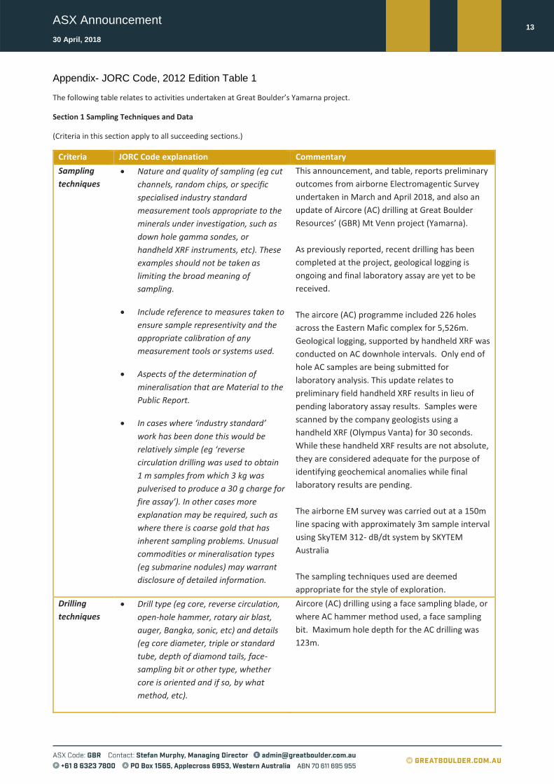
Appendix- JORC Code, 2012 Edition Table 1
The following table relates to activities undertaken at Great Boulder’s Yamarna project.
Section 1 Sampling Techniques and Data
(Criteria in this section apply to all succeeding sections.)
Criteria JORC Code explanation Commentary
Sampling
techniques
• Nature and quality of sampling (eg cut
channels, random chips, or specific
specialised industry standard
measurement tools appropriate to the
minerals under investigation, such as
down hole gamma sondes, or
handheld XRF instruments, etc). These
examples should not be taken as
limiting the broad meaning of
sampling.
• Include reference to measures taken to
ensure sample representivity and the
appropriate calibration of any
measurement tools or systems used.
• Aspects of the determination of
mineralisation that are Material to the
Public Report.
• In cases where ‘industry standard’
work has been done this would be
relatively simple (eg ‘reverse
circulation drilling was used to obtain
1 m samples from which 3 kg was
pulverised to produce a 30 g charge for
fire assay’). In other cases more
explanation may be required, such as
where there is coarse gold that has
inherent sampling problems. Unusual
commodities or mineralisation types
(eg submarine nodules) may warrant
disclosure of detailed information.
This announcement, and table, reports preliminary
outcomes from airborne Electromagentic Survey
undertaken in March and April 2018, and also an
update of Aircore (AC) drilling at Great Boulder
Resources’ (GBR) Mt Venn project (Yamarna).
As previously reported, recent drilling has been
completed at the project, geological logging is
ongoing and final laboratory assay are yet to be
received.
The aircore (AC) programme included 226 holes
across the Eastern Mafic complex for 5,526m.
Geological logging, supported by handheld XRF was
conducted on AC downhole intervals. Only end of
hole AC samples are being submitted for
laboratory analysis. This update relates to
preliminary field handheld XRF results in lieu of
pending laboratory assay results. Samples were
scanned by the company geologists using a
handheld XRF (Olympus Vanta) for 30 seconds.
While these handheld XRF results are not absolute,
they are considered adequate for the purpose of
identifying geochemical anomalies while final
laboratory results are pending.
The airborne EM survey was carried out at a 150m
line spacing with approximately 3m sample interval
using SkyTEM 312- dB/dt system by SKYTEM
Australia
The sampling techniques used are deemed
appropriate for the style of exploration.
Drilling
techniques
• Drill type (eg core, reverse circulation,
open-hole hammer, rotary air blast,
auger, Bangka, sonic, etc) and details
(eg core diameter, triple or standard
tube, depth of diamond tails, face-
sampling bit or other type, whether
core is oriented and if so, by what
method, etc).
Aircore (AC) drilling using a face sampling blade, or
where AC hammer method used, a face sampling
bit. Maximum hole depth for the AC drilling was
123m.

ASX Announcement
30 April, 2018
14
Drill sample
recovery
• Method of recording and assessing
core and chip sample recoveries and
results assessed.
• Measures taken to maximise sample
recovery and ensure representative
nature of the samples.
• Whether a relationship exists between
sample recovery and grade and
whether sample bias may have
occurred due to preferential loss/gain
of fine/coarse material.
Logging of all samples followed established
company procedures which included recording of
qualitative fields to allow discernment of sample
reliability. This included (but was not limited to)
recording: sample condition, sample recovery,
sample method.
While no issues relating to sample recovery have
been note, final recovery assessment has not been
completed.
No quantitative analysis of samples weights,
sample condition or recovery has been
undertaken.
No quantitative twinned drilling analysis has been
undertaken at the project.
Logging • Whether core and chip samples have
been geologically and geotechnically
logged to a level of detail to support
appropriate Mineral Resource
estimation, mining studies and
metallurgical studies.
• Whether logging is qualitative or
quantitative in nature. Core (or
costean, channel, etc) photography.
• The total length and percentage of the
relevant intersections logged.
Geological logging of samples followed established
company and industry common procedures.
Qualitative logging of samples included (but was
not limited to) lithology, mineralogy, alteration and
weathering. Logging was supported by the use of
a handheld XRF.
Sub-
sampling
techniques
and sample
preparation
• If core, whether cut or sawn and
whether quarter, half or all core taken.
• If non-core, whether riffled, tube
sampled, rotary split, etc and whether
sampled wet or dry.
• For all sample types, the nature,
quality and appropriateness of the
sample preparation technique.
• Quality control procedures adopted for
all sub-sampling stages to maximise
representivity of samples.
• Measures taken to ensure that the
sampling is representative of the in
situ material collected, including for
instance results for field
duplicate/second-half sampling.
Aircore (AC) drill chips were collected as 4m
composite samples from bulk piles laid out next to
the drillhole collar using a handheld scoop. Only
end of hole samples are submitted for laboratory
analysis. Entire samples were pulverised. No field
duplicates were taken.
Samples were scanned by the company geologists
using a handheld XRF (Olympus Vanta) for 30
seconds. While these handheld XRF results are not
absolute, they are considered adequate for the
purpose of identifying geochemical anomalies
while final results laboratory results are pending.
All samples were submitted to ALS Minerals
(Kalgoorlie) for analyses. The sample preparation
included:
Samples were weighed, crushed (such
that a minimum of 70% pass 2mm) and

ASX Announcement
30 April, 2018
15
• Whether sample sizes are appropriate
to the grain size of the material being
sampled.
pulverised (such that a minimum of 85%
pass 75um) as per ALS standards.
A 4 acid digest (HNO3-HBr-HF-HCl) and
ICP-AES (ALS method; MS-ICP61g) was
used for 33 multi-elements. This also
included Co, Cu, Ni, Zn. Note: ME-MS61g
uses HBr in lieu of HClO3 (used in ME-
MS61 4 acid digest). This change relates to
improving resolution of sulphur values in
Mt Venn mineralsation.
For elements that reported over range,
ALS used ore grade 4 acid digest and ICP-
AES methods; (nickel) Ni-OG62, (copper)
Cu-OG62.
Sulphur over range used ALS method S-
IR08 (Leco Sulphur analyzer).
Iron over range used ALS method Fe-ICP81 (Sodium Peroxide Fusion).
Sample collection, size and analytical methods are
deemed appropriate for the style of exploration.
Quality of
assay data
and
laboratory
tests
• The nature, quality and
appropriateness of the assaying and
laboratory procedures used and
whether the technique is considered
partial or total.
• For geophysical tools, spectrometers,
handheld XRF instruments, etc, the
parameters used in determining the
analysis including instrument make
and model, reading times, calibrations
factors applied and their derivation,
etc.
• Nature of quality control procedures
adopted (eg standards, blanks,
duplicates, external laboratory checks)
and whether acceptable levels of
accuracy (ie lack of bias) and precision
have been established.
• Final laboratory assay results are pending.
Samples were scanned by the company geologists
using a handheld XRF (Olympus Vanta) for 30
seconds (15 sec. Beam 1, 15 sec. Beam 2). No
blanks or standards were used to calibrate the
handheld XRF. While these handheld XRF results
are not absolute, they are considered adequate for
the purpose of identifying geochemical anomalies
while final results laboratory results are pending.
Drilling has been completed and geological logging
is still being finalized. No final assay results have
yet been received.
Verification
of sampling
and
assaying
• The verification of significant
intersections by either independent or
alternative company personnel.
• The use of twinned holes.
• Documentation of primary data, data
entry procedures, data verification,
No verification of sampling and assaying has been
undertaken in this exploration programme.
No final assay results have yet been received.
Great Boulder has strict procedures for data
capture, flow and data storage, and validation.

ASX Announcement
30 April, 2018
16
data storage (physical and electronic)
protocols.
• Discuss any adjustment to assay data.
Location of
data points
• Accuracy and quality of surveys used
to locate drill holes (collar and down-
hole surveys), trenches, mine workings
and other locations used in Mineral
Resource estimation.
• Specification of the grid system used.
• Quality and adequacy of topographic
control.
• Drill collars were set out using a hand held GPS and
final collar were collected using a handheld GPS.
• Downhole surveys were completed by survey
contractors using a north-seeking gyroscope.
Holes without downhole survey use planned or
compass bearing/dip measurements for survey
control.
• The MGA94 UTM zone 51 coordinate system was
used for all undertakings.
Data
spacing and
distribution
• Data spacing for reporting of
Exploration Results.
• Whether the data spacing and
distribution is sufficient to establish
the degree of geological and grade
continuity appropriate for the Mineral
Resource and Ore Reserve estimation
procedure(s) and classifications
applied.
• Whether sample compositing has been
applied.
The spacing and location of the majority of the
drilling in the projects is, by the nature of early
exploration, variable.
The spacing and location of data is currently only
being considered for exploration purposes.
Orientation
of data in
relation to
geological
structure
• Whether the orientation of sampling
achieves unbiased sampling of possible
structures and the extent to which this
is known, considering the deposit type.
• If the relationship between the drilling
orientation and the orientation of key
mineralised structures is considered to
have introduced a sampling bias, this
should be assessed and reported if
material.
Drilling was nominally perpendicular to regional
mineralisation trends where interpreted and
practical. True width and orientation of
intersected mineralisation is currently unknown.
A list of the drillholes and orientations are
reported with significant intercepts is provided as
an appended table.
The spacing and location of the data is currently
only being considered for exploration purposes.
Sample
security
• The measures taken to ensure sample
security.
Great Boulder has strict chain of custody
procedures that are adhered to for drill samples.
All sample bags are pre-printed and pre-numbered.
Sample bags are placed in a polyweave bags (up to
5 samples) and closed with a zip tie such that no
sample material can spill out and no one can
tamper with the sample once it leaves the
company’s custody.

ASX Announcement
30 April, 2018
17
Audits or
reviews
• The results of any audits or reviews of
sampling techniques and data.
None completed.
Section 2 Reporting of Exploration Results
(Criteria listed in the preceding section also apply to this section.)
Criteria JORC Code explanation Commentary
Mineral
tenement and
land tenure
status
• Type, reference name/number,
location and ownership including
agreements or material issues with
third parties such as joint ventures,
partnerships, overriding royalties,
native title interests, historical sites,
wilderness or national park and
environmental settings.
• The security of the tenure held at
the time of reporting along with any
known impediments to obtaining a
license to operate in the area.
Great Boulder Resource Ltd (GBR) is comprised
of several projects with associated tenements;
Yamarna tenements and details;
Exploration licences E38/2685, E38/2952,
E38/2953, E38/5957, E38/2958, E38/2320 and
prospecting licence P38/4178 where,
GBR has executed a JV agreement to earn 75%
interest through exploration expenditure of
$2,000,000 AUD over five years. Following
satisfaction of the minimum expenditure
commitment by GBR, EGMC (current tenement
owner) will have the right to contribute to
expenditure in the project at its 25% interest
level or choose to convert to a 2% Net Smelter
Royalty (NSR). Should EGMC choose to convert
its remaining interest into a 2% NSR, then GBR
will have a 100% interest in the project.
Exploration
done by other
parties
• Acknowledgment and appraisal of
exploration by other parties.
Previous explorers included:
1990’s. Kilkenny Gold NL completed
wide-spaced, shallow, RAB drilling
over a limited area. Gold assay only.
2008. Elecktra Mines Ltd (now Gold
Road Resources Ltd) completed two
shallow RC holes targeting extension
to Mt Venn igneous complex. XRF
analysis only, no geochemical analysis
completed.
2011. Crusader Resources Ltd
completed broad-spaced aircore
drilling targeting extensions to
Thatcher’s Soak uranium
mineralisation. XRF anlaysis only, no
geochemical analysis completed.
In late 2015 Gold Road drilled and
assayed an RC drill hole on the edge of
an EM anomaly identified from an
airborne XTEM survey, identifying
copper-nickel-cobalt mineralisation.

ASX Announcement
30 April, 2018
18
Geology • Deposit type, geological setting and
style of mineralisation.
Great Boulder’s Yamarna Project hosts the
southern extension of the Mt Venn igneous
complex. This complex is immediately west of
the Yamarna greenstone belt.
The mineralisation encountered in the Mt Venn
drilling suggests that sulphide mineralisation is
prominent along a EM conductor trend, and
shows a highly sulphur-saturated system within
metamorphosed dolerite and gabbro sequence.
Visual logging of sulphide mineralogy shows
pyrrhotite dominant with chalcopyrite.
Drill hole
Information
• A summary of all information
material to the understanding of the
exploration results including a
tabulation of the following
information for all Material drill
holes:
o easting and northing of the drill hole
collar
o elevation or RL (Reduced Level –
elevation above sea level in metres)
of the drill hole collar
o dip and azimuth of the hole
o down hole length and interception
depth
o hole length.
• If the exclusion of this information is
justified on the basis that the
information is not Material and this
exclusion does not detract from the
understanding of the report, the
Competent Person should clearly
explain why this is the case.
A complete list of the reported significant
results from Great Boulder’s drilling is provided
in the body of the report.
A list of the drillhole coordinates and metrics
are provided as an appended table.
Data
aggregation
methods
• In reporting Exploration Results,
weighting averaging techniques,
maximum and/or minimum grade
truncations (eg cutting of high
grades) and cut-off grades are
usually Material and should be
stated.
• Where aggregate intercepts
incorporate short lengths of high
grade results and longer lengths of
low grade results, the procedure
used for such aggregation should be
stated and some typical examples of
No weight averaging techniques, aggregation
methods or grade truncations were applied to
these exploration results.
No metal equivalents are used.

ASX Announcement
30 April, 2018
19
such aggregations should be shown
in detail.
• The assumptions used for any
reporting of metal equivalent values
should be clearly stated.
Relationship
between
mineralisatio
n widths and
intercept
lengths
• These relationships are particularly
important in the reporting of
Exploration Results.
• If the geometry of the mineralisation
with respect to the drill hole angle is
known, its nature should be
reported.
• If it is not known and only the down
hole lengths are reported, there
should be a clear statement to this
effect (eg ‘down hole length, true
width not known’).
The orientation of structures and
mineralisation is not known with certainty but
drilling was conducted using appropriate
orientations for interpreted mineralisation.
True width and orientation of intersected
mineralisation is currently unknown.
A list of the drillholes and orientations are
reported with significant intercepts is provided
as an appended table.
Diagrams • Appropriate maps and sections (with
scales) and tabulations of intercepts
should be included for any significant
discovery being reported These
should include, but not be limited to
a plan view of drill hole collar
locations and appropriate sectional
views.
Refer to figures in announcement.
Balanced
reporting
• Where comprehensive reporting of
all Exploration Results is not
practicable, representative reporting
of both low and high grades and/or
widths should be practiced to avoid
misleading reporting of Exploration
Results.
It is not practical to report all exploration
results. Low or non-material grades have not
been reported.
All drill hole locations are reported and a table
of significant intervals is provided in the
announcement.
Other
substantive
exploration
data
• Other exploration data, if
meaningful and material, should be
reported including (but not limited
to): geological observations;
geophysical survey results;
geochemical survey results; bulk
samples – size and method of
treatment; metallurgical test results;
bulk density, groundwater,
geotechnical and rock
characteristics; potential deleterious
or contaminating substances.
In late 2015 Gold Road drilled and assayed an
RC drill hole on the edge of an EM anomaly
identified from an airborne XTEM survey,
identifying copper-nickel-cobalt mineralisation.
Great Boulder subsequently re-assayed the
hole and confirmed primary bedrock sulphide
mineralisation, with peak assay results of 1.7%
Cu, 0.2% Ni, 528ppm Co (over 1m intervals)
over two distinct lenses.
Great Boulder completed a ground based
moving loop EM survey in September 2017 and
reported extensive strong EM conductors and
co-incident copper-nickel mineralisation from

ASX Announcement
30 April, 2018
20
aircore geochemistry (refer to announcement
dated 5 October 2017).
Great Boulder has also recently undertaken RC
and DD exploratory drilling with down hole EM
surveys.
Further work • The nature and scale of planned
further work (eg tests for lateral
extensions or depth extensions or
large-scale step-out drilling).
• Diagrams clearly highlighting the
areas of possible extensions,
including the main geological
interpretations and future drilling
areas, provided this information is
not commercially sensitive.
Potential work across the project may include
detailed additional geological mapping and
surface sampling, additional geophysical
surveys (either surface or downhole), and
potentially additional confirmatory or
exploratory drilling.