Embed Size (px)
Citation preview

High Latitude Eruptions – Climatic Effects By Joseph D’Aleo
In the last three years, several high latitude volcanoes have erupted – Kasatochi in Alaska in 2008, Mt. Redoubt in Alaska and Sarychev in Russia in 2009 and now Eyjafjallajökull in Iceland in 2010.
Climatologists may disagree on how much the recent global warming is natural or manmade but there is general agreement that volcanism constitutes a wildcard in climate, producing significant global scale cooling for at least a few years following a major eruption. However, there are some interesting seasonal and regional variations of the effects.
Oman et al (2005) and others have shown that though major volcanic eruptions seem to have their greatest cooling effect in the summer months, the location of the volcano determines whether the winters are colder or warmer over large parts of North America and Eurasia. According to their modeling, tropical region volcanoes like El Chichon and Pinatubo actually produce a warming in winter due to a tendency for a more positive North Atlantic Oscillation (NAO) and Arctic Oscillation (AO). In the positive phase of these large scale pressure oscillations, low pressure and cold air is trapped in high latitudes and the resulting more westerly jet stream winds drives milder maritime air into the continents.

Oman found high latitude volcanoes like Katmai (Alaska in 1912) instead favored the negative phase of the Arctic and North Atlantic Oscillations and cold winters. In the negative phase, the jet stream winds buckled and forced cold air south from Canada into the eastern United States and west from Siberia into Europe. They also favored a cooling of middle and higher latitudes the year round of that atmosphere and a weakening of the summer monsoon in India and Africa.
Here is the abstract of that paper: “Strong volcanic eruptions can inject large amounts of SO2 into the lower stratosphere, which over time, are converted into sulfate aerosols and have the potential to impact climate. Aerosols from tropical volcanic eruptions like the 1991 Mount Pinatubo eruption spread over the entire globe, whereas high-latitude eruptions typically have aerosols which remain in the hemisphere in which they where injected. This causes their largest radiative forcing to be extratropical, and the climate response should be different from that of tropical eruptions. We conducted a 20-member ensemble simulation of the climate response to the Katmai eruption (58N) of 6 June 1912 using the NASA Goddard Institute for Space Studies ModelE climate model. We also produced an additional 20-member ensemble for a 3 times Katmai (3x Katmai) eruption to see the impact the strength of the eruption has on the radiative as well as the dynamical responses. The results of these simulations do not show a positive Arctic Oscillation response like past simulations of tropical volcanic eruptions, but we did find significant cooling over southern Asia during the boreal winter. The first winter following Katmai and the second winter following 3x Katmai showed strong similarities in lower stratospheric geopotential height anomalies and sea level pressure anomalies, which occurred when the two cases had similar optical depth perturbations. These simulations show that the radiative impact of a high-latitude volcanic eruption was much larger than the dynamical impact at high latitudes. In the boreal summer, however, strong cooling over the Northern Hemisphere landmasses caused a decrease in the Asian monsoon circulation with significant decreases of up to 10% in cloud cover and warming over northern India. Thus the main dynamical impact of high latitude eruptions is in the summer over Asia.” Lets look at volcanic activity in Alaska, Iceland and Kamchatka in eastern Russia.

ALASKA AND KAMCHATKA VOLCANO MAP
Intreractive map here. Red over Alaska is Redoubt, yellow on Aleutians is Mt Cleveland. MT. REDOUBT
Starting on March 22, 2010 a series of major eruptions have taken place from Mt. Redoubt in Alaska. The biggest exceeded 65,000 feet in height. More than a dozen eruptions as high as 60,000 have followed the first week alone. Activity may continue for weeks or months based on the volcano’s history.
Mt. Redoubt March 26, 2009

Mount Redoubt has erupted five times since 1900: in 1902, 1922, 1966, 1989 and 2009. The eruption in 1989 spewed volcanic ash to a height of 14,000 m (45,000 ft) and managed to catch KLM Royal Dutch Airlines flight 867, a Boeing 747 aircraft, in its plume (the flight landed safely at Anchorage). The 1989 eruption is also notable for being the first ever volcanic eruption to be successfully predicted by the method of long-period seismic events developed by Swiss/American volcanologist Bernard Chouet.

An aerial view of Redoubt Volcano looking north on December 18, 1989 showing a low-level eruption of steam and ash. Photograph by W. White, U.S. Geological Survey
Mt. Redoubt April 21, 1990. Photograph by R. Clucas.

MT. CLEVELAND On Monday, February 19, 2001, Cleveland volcano in the east central Aleutians erupted explosively sending ash to 35,000 feet. The explosive event lasted less than one day.
Historical eruptions at Mt. Cleveland have been characterized by short-lived explosive bursts of ash, at times accompanied by lava fountaining, lava flows, and debris flows down the flanks. On May 25, 1994 sent a short-lived ash plume to about 10.5 km (35,000 ft) altitude (photo above and below).

MT. SPURR
Crater Peak, the active vent of Mount Spurr, Alaska, on 26 September 1992 erupted in June, August, and September 1992. Ash from the August eruption closed Anchorage International Airport. Photo is from June 27, 1992.
Mt. Spurr is a stratovolcano in Alaska. It is composed mostly of andesite. The Spurr volcanic complex was built on the remains of an older volcano. The present Mt. Spurr grew in the center of the old caldera. The original volcano was an andesitic stratovolcano. It is about 12 miles (19 km) around. Snow and ice cover the north side. The caldera is breached to the south. It contains an ice field which feeds glaciers in all directions.
A dome grew in the center of the old volcano's caldera to form the present Spurr. This volcano is mostly covered with ice. The exposed ground around the volcano has fumaroles which are near the boiling point. A small summit crater sometimes melts some of the ice on the volcano. Fumarole activity from this crater was the only activity before 1953. A second cone called Crater Peak grew in the breach of the older volcano. This was the sight of a major ash eruption on July 9, 1953. The most recent eruption of Spurr was in 1992.

MT AUGUSTINE
Historic eruptions were recorded in 1812, 1883, 1935, 1963-64, 1976, and 1986. Augustine's eruptions tend to be highly explosive and tend to spread ash across the Cook Inlet region.
KASATOCHI Kasatochi Volcano, a small, 3 km diameter, 300 m high, island volcano in the central Aleutian Islands of Alaska (52.1693 degrees N latitude, 175.5113 degrees W longitude) erupted violently on August 7, 2008 after an intense period of precursory seismic activity. The eruption was characterized by three distinct explosions that were detected by the seismic network on Great Sitkin Volcano, at approximately 2:01 PM, 5:50 PM, and 8:35 PM AKDT. The first two events produced relatively ash-poor, but gas-charged, eruption

clouds that reached 45,000 - 50,000 feet above sea level and apparently no or very little local ash fall. The third event generated an ash- and gas-rich plume that also rose to 45,000 - 50,000 feet and produced several inches of ash and lapilli fall over the ocean and on islands southwest of Kasatochi, including minor amounts on Adak Island, the closest island with a year-round population, about 50 miles from the volcano. Boats in the vicinity of the volcano reported 4-5 inches of coarse grained ash fall, darkening skies, and lightning, likely caused by static electricity in the ash plume. The third event was followed by about 17 hours of continuous ash emission as determined from satellite data. The cumulative volcanic cloud from Kasatochi contained a large amount of sulfur dioxide gas that was detected by the Ozone Monitoring Instrument on NASA's EOS-Aura satellite for more than a week after the eruption as the cloud circled the globe.
Kasatochi may have played a role in the cool summer in the north central US in 2008. KATMAI/NOVARUPTA
The largest eruption in the world last century (VEI=6) occurred in 1912 at Novarupta on the Alaska Peninsula. An estimated 15 to 30 cubic kilometers of magma was explosively erupted during 60 hours beginning on June 6 -- about 30 to 60 times the volume erupted by Mount St. Helens in 1980! The expulsion of such a large volume of magma excavated a funnel-shaped vent 2 kilometers wide and triggered the collapse of Mount Katmai volcano. Katmai was once a cluster of 3 or 4 small volcanoes. Pyroclastic flows traveled

as far as 15 miles (23 km) and filled a valley adjacent to the volcano to produce the Valley of Ten Thousand Smokes. The withdrawal of magma from beneath the cluster of small volcanoes at Katmai caused the area to collapse and produce a caldera. A lake has filled part of the caldera.
"The magnitude of the eruption can perhaps be best realized if one could imagine a similar outburst centered in New York City. All of Greater New York would be buried under from ten to fifteen feet of ash; Philadelphia would be covered by a foot of gray ash and would be in total darkness for sixty hours; Washington and Buffalo would receive a quarter of an inch of ash, with a shorter period of darkness. The sound of the explosion would be heard in Atlanta and St. Louis, and the fumes noticed as far away as Denver, San Antonio, and Jamaica." (Robert F. Griggs, National Geographic Magazine, 1917, v. 81 no. 1, p. 50)
Katmai from the summit of Griggs. Katmai is in the middle and to the right. Photo by Jay Robinson, National Park Service.
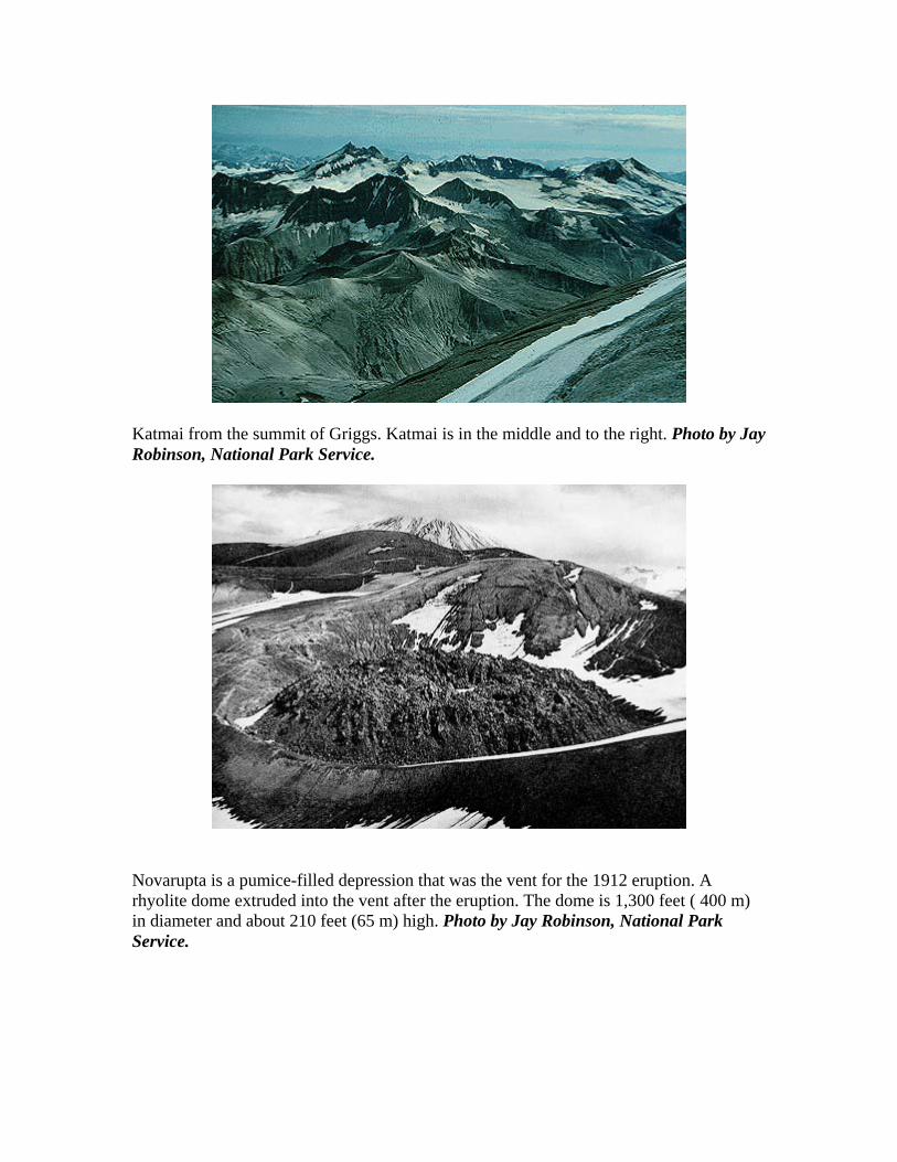
Novarupta is a pumice-filled depression that was the vent for the 1912 eruption. A rhyolite dome extruded into the vent after the eruption. The dome is 1,300 feet ( 400 m) in diameter and about 210 feet (65 m) high. Photo by Jay Robinson, National Park Service.

MT. VENIAMINOF
Veniaminof is a large stratovolcano that suffered a huge caldera-forming eruption about 3,700 years ago. The caldera is almost 6 miles (10 km) across and filled with ice and snow. All the recent eruptions have taken place from a cinder cone that pokes up through the ice in the caldera. Both the 1983-84 and June 1993 eruption have consisted of fountaining at this cinder cone. Additionally, lava flows flow down the sides of the cone and onto the ice surface where they then melt their way down through to the bottom of the caldera and then a lake forms. This photo shows active lava flows on January 23, 1984. Flows from November 1983 are covered with snow. Photo courtesy of U.S. Geological Survey.
There are very few people who live nearby so the danger to humans is pretty small. One of the things they worry about is called a jokulhlaup. This is an unpronounceable Icelandic word. A jokulhlaup happens when an eruption occurs under a thick ice sheet. The eruption will often melt the bottom of the glacier. If the eruption keeps on long enough pretty soon the glacier will float up on its own melted water (ice floats). As soon as this happens all that melted water can escape out from under the glacier and you get a big flood. This happens pretty often in Iceland, and it is a possibility at Veniaminof.

Eruption of Veniaminof on January 23, 1984. From front cover of USGS in Alaska:
ICELAND VOLCANOS LAKI

Laki, volcano, 2,684 ft (818 m) high, S Iceland, at SW edge of the Vatnajökull glacier. Its eruption in 1783 was one of the more devastating on record, leading to the deaths of a quarter of Iceland's inhabitants (mainly due to a famine that resulted from the eruption's effects). Haze from the eruption spread over parts of Europe, where some experts believe it affected the inhabitants' health. Surrounding the crater are the Lakagígar series of 100 volcanic rifts.
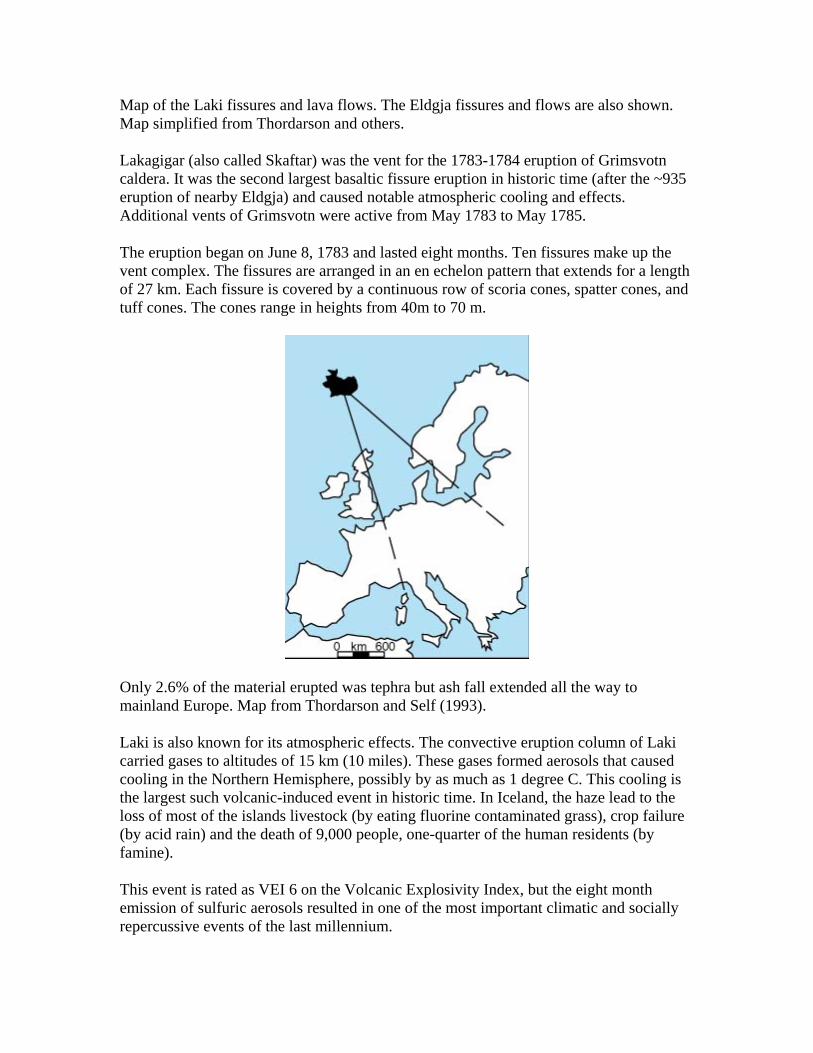
Map of the Laki fissures and lava flows. The Eldgja fissures and flows are also shown. Map simplified from Thordarson and others.
Lakagigar (also called Skaftar) was the vent for the 1783-1784 eruption of Grimsvotn caldera. It was the second largest basaltic fissure eruption in historic time (after the ~935 eruption of nearby Eldgja) and caused notable atmospheric cooling and effects. Additional vents of Grimsvotn were active from May 1783 to May 1785.
The eruption began on June 8, 1783 and lasted eight months. Ten fissures make up the vent complex. The fissures are arranged in an en echelon pattern that extends for a length of 27 km. Each fissure is covered by a continuous row of scoria cones, spatter cones, and tuff cones. The cones range in heights from 40m to 70 m.
Only 2.6% of the material erupted was tephra but ash fall extended all the way to mainland Europe. Map from Thordarson and Self (1993).
Laki is also known for its atmospheric effects. The convective eruption column of Laki carried gases to altitudes of 15 km (10 miles). These gases formed aerosols that caused cooling in the Northern Hemisphere, possibly by as much as 1 degree C. This cooling is the largest such volcanic-induced event in historic time. In Iceland, the haze lead to the loss of most of the islands livestock (by eating fluorine contaminated grass), crop failure (by acid rain) and the death of 9,000 people, one-quarter of the human residents (by famine).
This event is rated as VEI 6 on the Volcanic Explosivity Index, but the eight month emission of sulfuric aerosols resulted in one of the most important climatic and socially repercussive events of the last millennium.

In Great Britain, the summer of 1783 was known as the "sand-summer" due to ash fallout. The eruption continued until 7 February 1784. Grímsvötn volcano, from which the Laki fissure extends, was also erupting at the time from 1783 until 1785. The outpouring of gases, including an estimated 8 million tons of fluorine and estimated 120 million tons of sulfur dioxide gave rise to what has since become known as the "Laki haze" across Europe. This was the equivalent of three times the total annual European industrial output in 2006, and also equivalent to a Mount Pinatubo-1991 eruption every three days. This outpouring of sulfur dioxide during unusual weather conditions caused a thick haze to spread across western Europe, resulting in many thousands of deaths throughout 1783 and the winter of 1784.
The poisonous cloud drifted to Bergen in Norway, then spread to Prague in the Province of Bohemia by 17 June, Berlin by 18 June, Paris by 20 June, Le Havre by 22 June, and to Great Britain by 23 June. The fog was so thick that boats stayed in port, unable to navigate, and the sun was described as "blood coloured"
This disruption then led to a most severe winter in 1784, where an estimated to have caused 8,000 additional deaths in the UK. In the spring thaw, Germany and Central Europe then reported severe flood damage.
In North America, the winter of 1784 was the longest and one of the coldest on record. It was the longest period of below-zero temperatures in New England, the largest accumulation of snow in New Jersey, and the longest freezing over of Chesapeake Bay. There was ice skating in Charleston Harbor, a huge snowstorm hit the south, the Mississippi River froze at New Orleans, and there was ice in the Gulf of Mexico.
GRÍMSVÖTN
Grímsvötn is a central volcano in the Grímsvötn volcanic system of Iceland. This system is about 62 miles (100 km) long and ~9 miles (15 km) wide. It is mostly covered with ice named Vatnajokull. The total volume of lava erupted from the Grimsvotn system is about 50-55 cubic km. Only about 19 cubic km of this lava is not covered by the ice. The system rises to the northeast from about 1000 ft (300 m) above sea level in the southwest. It reaches its tallest point at Grímsvötn volcano. This volcano has a 35 sq km caldera. A high temperature hydrothermal area is located in this caldera. Grímsvötn has erupted 45 times. The last major eruption of the volcano was in 1996 (shown in photo below).

HEKLA
Hekla is the most active volcano in Iceland with eruption events numbering from as low as 15 major eruptions to the huge number of 167 since 1104, the most recent being in 1991.

On 26 February, 2000 Iceland's most famous volcano, Mt. Hekla, began erupting at 1819 GMT. A 6-7 km long fissure appeared and a steam column rose nearly 15 km (45,000 feet) into the sky. A discontinuous curtain of fire emanated from the entire fissure. The lava flowed down the slopes of Hekla and covered a large part of the Hekla ridge. Most of the ash fell in uninhabited areas in the interior of Iceland. The eruption reached its peak intensity in the first hour of the activity. Icelanders in the Middle Ages called the volcano the "Gateway to Hell."
EYJAFJALLAJÖKULL
(Icelandic for "island-mountain glacier) is one of the smaller ice caps of Iceland, situated to the north of Skógar and to the west of Mýrdalsjökull. The ice cap covers the caldera of the volcano with a summit elevation of 1,666 metres (5,466 ft). The volcano has erupted relatively frequently since the last glacial period, most recently from 1821 to 1823 and again in 2010.
The ice cap covers an area of about 100 square kilometres (39 sq mi), feeding many outlet glaciers. The south end of the mountain was once part of the island's Atlantic coastline, but over thousands of years the sea retreated some 5 kilometres (3.1 mi), with the former coastline now consisting of sheer cliffs with many waterfalls, of which the best known is Skógafoss. In strong winds, the water of the smaller falls can even be blown up the mountain.
The volcano, which has a crater 3–4 kilometres (1.9–2.5 mi) in diameter, erupted in 920, 1612 and again from 1821 to 1823 when it caused a glacial lake outburst flood or jökulhlaup. It has erupted twice in 2010—on 20 March and in April/May. The March event forced a brief evacuation of around 500 local people but the 14 April eruption was ten to twenty times more powerful and caused substantial disruption to air traffic across Europe, and is ongoing.

KATLA
Katla is one of the most active volcanoes in Iceland, with two eruptions each century on average. The volcanic centre is located on the east margin of the eastern volcanic zone in Iceland, above a junction of linear rift tectonics and a steep increase in crustal thickness, compared to the rift zone north of the volcano. The volcano massif rises to an elevation of 1512 m and is partly covered by the 200-700 m thick Mýrdalsjökull glacier which fills up a caldera of about 70 km3, and covers its eruptive vents.
The volcanic centre of 300 km3 is mainly formed in the time interval from 220 thousands years ago to Holocene.
The present composite caldera is formed stepwise during the last glaciation. The beginning of Holocene activity of the volcano is marked by the major explosive eruption named Sólheimar eruption, dated 12.000 BP by the Skógar (Vedde) tephra layer. The volume of eruptives from this eruption is estimated 6-7 km3, contributing significantly to the caldera subsidence.

Katla 1918
Results of a 2-D, seismic undershooting experiment on the Katla volcano indicate a shallow magma reservoir with bottom at depth of 3 km below the surface of the ice cap (Gudmundsson et al., 1994). Thickness of the magma reservoir was estimated 1 km, and roughly assumed volume could be 10-12 km3 . According to these measurements the magma reservoir can only be defined as a volume where the relative melt content is high enough to create a significant S-wave shadow.
The volcanic activity in historical times is characterized by high eruption frequency, and production of Fe-Ti basalts and minor amount of silicic tephra. In spite of the dominating basaltic composition of magma, all eruptions are highly explosive due to the subglacial mode of extrusion. The most recent major eruption of Katla occurred in 1918, but possibly a small eruption that did not break the ice cover occurred in 1955. Similar smaller events may also have occurred in historical time.
Katla has been showing signs of unrest since 1999 and geologists have concerns that it might erupt in the near future. Particularly, monitoring has been intensified following the March 2010 eruptions of a smaller neighbouring volcano - Guðnasteinn - beneath the Eyjafjallajökull glacier. The eruption of this nearby long-dormant volcano in March and April 2010 prompted fears among some geophysicists that it might trigger an eruption at the larger and more dangerous Katla. In the past 1,000 years, all three known eruptions of Eyjafjallajökull have triggered subsequent Katla eruption.

KAMCHATKA VOLCANOS BEZYMIANNY
A steaming lava dome fills much of the large horseshoe-shaped crater cutting the ESE side of Bezymianny volcano in this late-1980's view from the SE. The crater was formed during a dramatic eruption in 1955-56, which was similar to that of Mount St. Helens in 1980. Prior to this eruption, Bezymianny volcano had been considered extinct. Subsequent episodic but ongoing lava-dome growth, accompanied by intermittent explosive activity and pyroclastic flows, has largely filled the 1956 crater. SUMMER AND WINTER Taking all the years of high latitude eruptions listed and composting them leads to a slightly cooler than normal summer in much of the lower 48 and a winter with cold in Canada and western United States with more variability and net warmth in the east. The winter pattern has the look of another La Nina.

References: Oman, L., A. Robock, G. Stenchikov, G. A. Schmidt, and R. Ruedy (2005), Climatic response to high-latitude volcanic eruptions, J. Geophys. Res., 110, D13103, doi:10.1029/2004JD005487

Smithsonian Institution USGS Global Volcanism Program: http://www.volcano.si.edu/reports/usgs/ Volcano World Oregon State University http://volcano.oregonstate.edu/ NASA GISS AOT: http://data.giss.nasa.gov/modelforce/strataer/


![Climatic response to high-latitude volcanic eruptions · 2009-09-24 · eruption of El Chicho´n.Graf and Timmreck [2001] simu-lated the aerosol radiative effects of the Laacher See](https://img.dokumen.tips/doc/110x75/5f590768d30229245175dbd6/climatic-response-to-high-latitude-volcanic-eruptions-2009-09-24-eruption-of-el.jpg)