Embed Size (px)
Citation preview
Hexagon: Shaping the Future of Smart
Cities
Claudio Mingrino Geospatial World Forum 2015Executive Director EMEA Lisbon, 26 May2015
Hexagon Geospatial

2
An introduction to Hexagon − a global leader in information technologies

MISSIONHexagon is dedicated to delivering actionable information through information technologies that enable customers to shape smart change across diverse business and industry landscapes.
VISIONVISIONHexagon aspires to play a leading role in the effort to solve the challenges our world is facing by providing groundbreaking information technologies that make a positive and lasting impact.
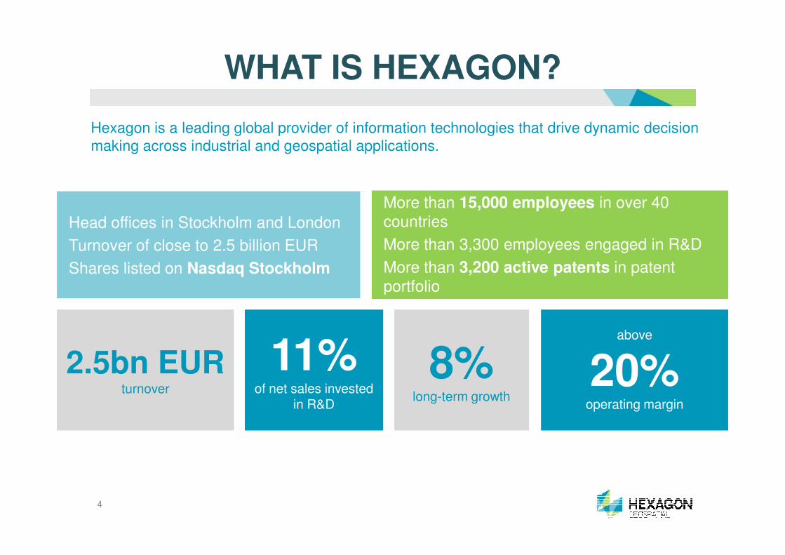
Head offices in Stockholm and London
Turnover of close to 2.5 billion EUR
Shares listed on Nasdaq Stockholm
More than 15,000 employees in over 40 countries
More than 3,300 employees engaged in R&D
More than 3,200 active patents in patent portfolio
Hexagon is a leading global provider of information technologies that drive dynamic decision
making across industrial and geospatial applications.
WHAT IS HEXAGON?
2.5bn EURturnover
8%long-term growth
above
20%operating margin
11%of net sales invested
in R&D
portfolio
4

The Hexagon Advantage
Shaping smart change with
information technologies
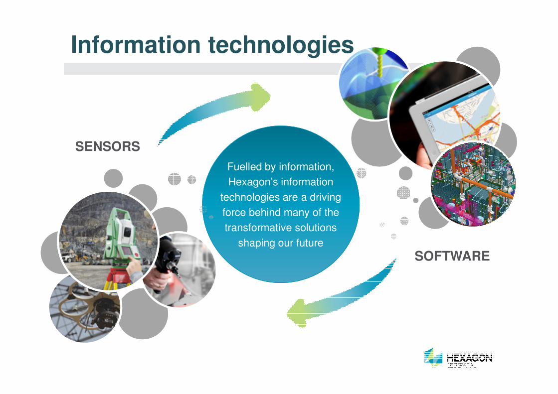
Fuelled by information,
Hexagon’s information
technologies are a driving
Information technologies
SENSORS
technologies are a driving
force behind many of the
transformative solutions
shaping our future
SOFTWARE

REAL DIGITAL
(as-is/as-built)
CAPTURE
Fusing the real and digital worlds
Fusing the real and digital REALWorld
DIGITALWorld
Fusing the real and digital
worlds delivers dynamic data
and actionable information
(as-planned/as-designed)
ACTION
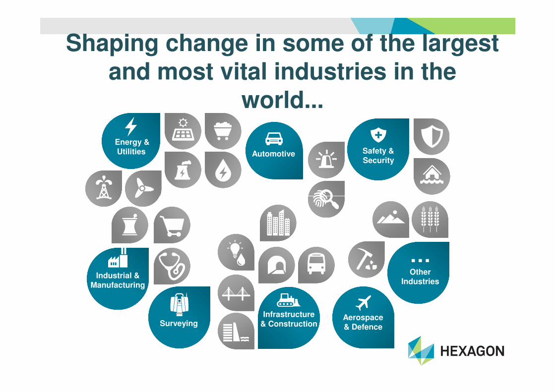
Shaping change in some of the largest and most vital industries in the
world...
Energy &Utilities Automotive Safety &
Security
…Other
Industries
Aerospace& Defence
Infrastructure& ConstructionSurveying
Industrial & Manufacturing
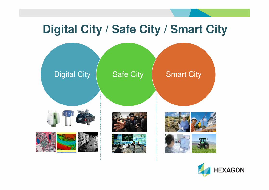
Digital City / Safe City / Smart City
Digital City Safe City Smart City

Core Competency
Sensor Integration
Mobile Workforce
ManagementStandard Operating
Procedures
Integration to other
Enterprise GIS
Procedures
Real-Time Data
ManagementAutomation of Manual
Work Processes
Image Capture,
Processing & Analysis
Enterprise Systems
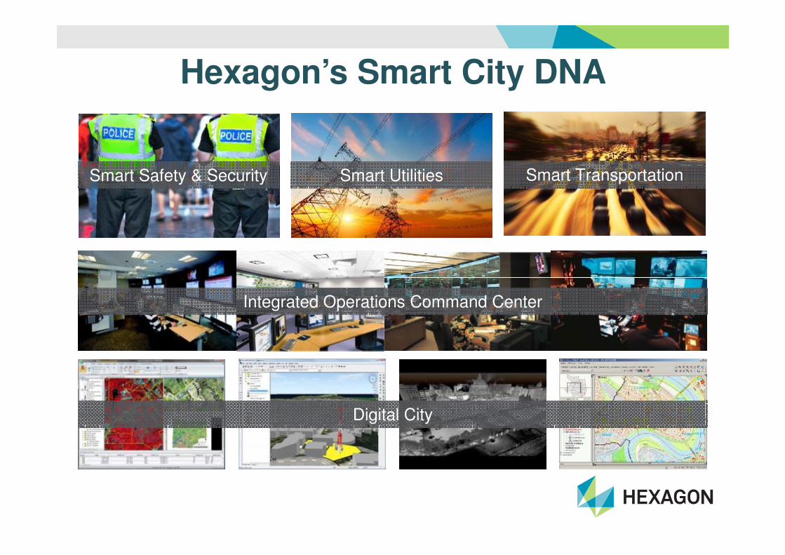
Hexagon’s Smart City DNA
Smart Safety & Security Smart Transportation Smart Utilities
Integrated Operations Command Center
Digital City

As in the Renaissance (“Rinascimento” in
Italian) it was conceived the ideal city,
Renaissance 2.0 is proposed as the
methodology for the “ideal” Smart City.
Renaissance 2.0 presents itself as essentially
Socratic method, which was developed to help
identify a shared vision of the “New” Town. This
vision - in which the innovative paradigms ofvision - in which the innovative paradigms of
Smart City are applied in accordance with the
traditions and vocations of the territory - is
expressed by administrators and citizens and
implemented in the project.To set a good Smart City project, it is
necessary to identify a shared SmartEngine, which is a factor that let an
investment to be sustainable and
compatible with the Genius Loci of the
city.The credibility and reliability of the
financial plan of the project will be a major
factor in the awarding of the public funds
(i.e. HORIZON 2020 funds).
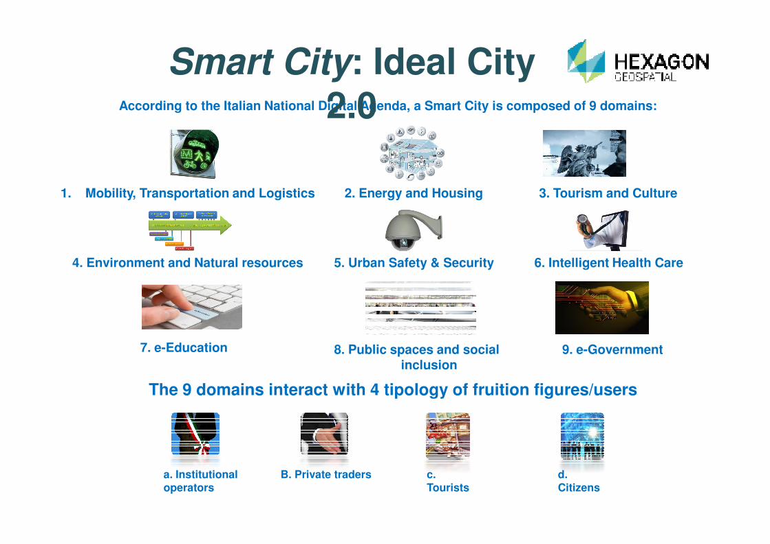
According to the Italian National Digital Agenda, a Smart City is composed of 9 domains:
Smart City: Ideal City 2.0
1. Mobility, Transportation and Logistics 2. Energy and Housing 3. Tourism and Culture
4. Environment and Natural resources 5. Urban Safety & Security 6. Intelligent Health Care
7. e-Education 8. Public spaces and social inclusion
9. e-Government
The 9 domains interact with 4 tipology of fruition figures/users
a. Institutionaloperators
B. Private traders c. Tourists
d. Citizens
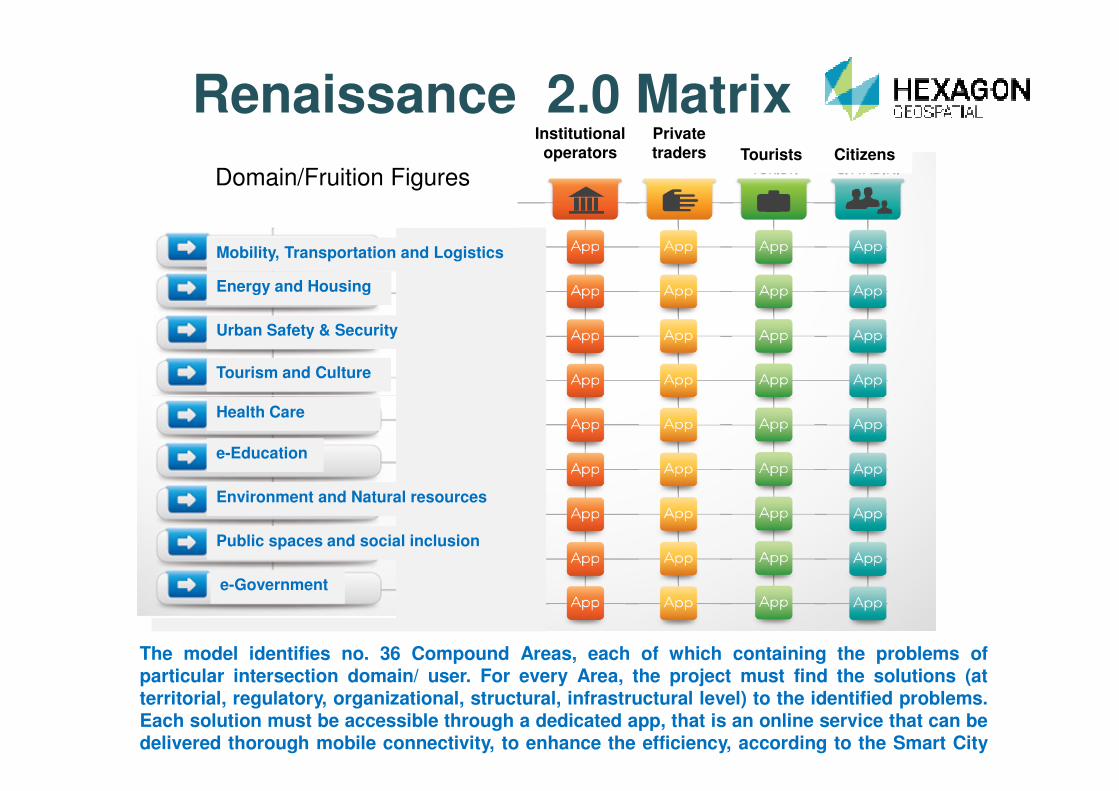
Renaissance 2.0 Matrix
Tourism and Culture
Urban Safety & Security
Energy and Housing
Mobility, Transportation and Logistics
Institutional operators
Private traders Tourists Citizens
Domain/Fruition Figures
The model identifies no. 36 Compound Areas, each of which containing the problems ofparticular intersection domain/ user. For every Area, the project must find the solutions (atterritorial, regulatory, organizational, structural, infrastructural level) to the identified problems.Each solution must be accessible through a dedicated app, that is an online service that can bedelivered thorough mobile connectivity, to enhance the efficiency, according to the Smart Cityparadigm .
e-Government
Public spaces and social inclusion
Environment and Natural resources
e-Education
Health Care
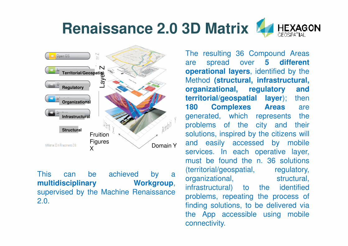
Renaissance 2.0 3D Matrix
La
ye
r Z
Infrastructural
Organizational
Regulatory
Territorial/Geospatial
The resulting 36 Compound Areas
are spread over 5 differentoperational layers, identified by the
Method (structural, infrastructural,organizational, regulatory andterritorial/geospatial layer); then
180 Complexes Areas are
generated, which represents the
problems of the city and their
This can be achieved by a
multidisciplinary Workgroup,
supervised by the Machine Renaissance
2.0.
Domain Y
Fruition Figures X
Structuralproblems of the city and their
solutions, inspired by the citizens will
and easily accessed by mobile
services. In each operative layer,
must be found the n. 36 solutions
(territorial/geospatial, regulatory,
organizational, structural,
infrastructural) to the identified
problems, repeating the process of
finding solutions, to be delivered via
the App accessible using mobile
connectivity.

The WorkGroup and the procedureThe WorkGroup is the working group
that interprets the Smart City vision of
the citizens and the administration
and transforms it into the final design
to be proposed for funding.
• Project Management is made upProject Management• Project Management is made up
of experts in the application of the
method and the use of the machine
Renaissance 2.0
• Quality Assurance and Advisoryshould be an expression of the
private enterprises involved in the
project.
• The domain specialists should be
representatives of the professions
and local businesses.
QualityAssuranc
e
Advisory
WorkGroup
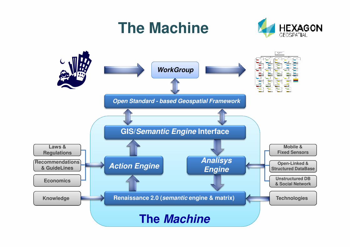
Open Standard - based Geospatial Framework
The Machine
GIS/Semantic Engine Interface
Action EngineAnalisysEngine
Renaissance 2.0 (semantic engine & matrix)
The Machine
Mobile & Fixed Sensors
Open-Linked & Structured DataBase
Unstructured DB & Social Network
Technologies
Economics
Laws & Regulations
Recommendations& GuideLines
Knowledge

The Machine will be composed by data mining tools, business intelligence and
meaning computing, semantic inference engines, integrated into the same platform with
a powerful GIS framework, based on already established standards for interoperability.
The Machine processing starts from an open data baseline and real-time data provided by
Spatial Data Infrastructure (SDI), in compliance with the INSPIRE Directive (2007/2/EC),open returned and according to the standards of interoperability of SDI.
The Machine operates according to the following basic requirements:
• Geospatial framework which processes the acquired data and, using the standard
Web Services of the Open Geospatial Consortium, returns solutions in a standard and
The Machine
Web Services of the Open Geospatial Consortium, returns solutions in a standard and
open format;
• Interoperability of GIS with business intelligence and sentiment analisysengines;
• Cloud Operativity and interfacing to any database: • Linked Open Data (LOD)
• Structured and unstructured Database
• Social Network
• Sensors network, with particular reference to the position of the users;• Smart City project support in all its phases:
• preliminary study, with built-in assistance for the preparation of SEAP
• sentiment analisys & business intelligence
• finding solutions
• implementation dashboard
• managing of network services
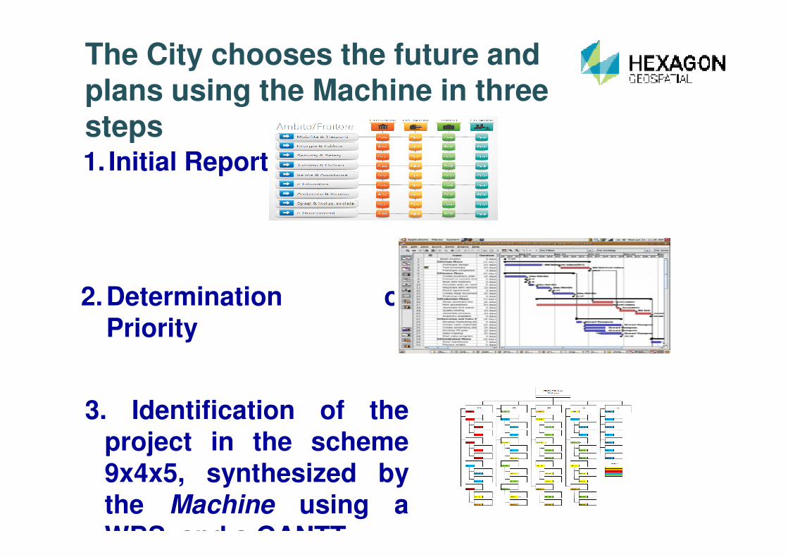
1. Initial Report
The City chooses the future and plans using the Machine in three steps
2.Determination ofPriority
3. Identification of theproject in the scheme9x4x5, synthesized bythe Machine using aWBS and a GANTT

The City monitors the implementation of the project
Using the Analysis Engine of theMachine, the Workgroup canevaluate and make available datarelated to the services provided,which can be represented on adashboard that represents theactions related to n. 9 Areas and n.
SelfAssessment
actions related to n. 9 Areas and n.4 Figures of fruition.
The dissemination of these data should be wide and on regular basis,through every form of media and can also be seen as a tool for localmarketing.
The ratings must be objective,provided by measurementinstruments, by predeterminedcriteria of status or by analysis ofthe sentiment of users
Institutional operators
Private traders Tourists Citizens

Smart Cities Are…
Intelligent Connected VisibleEfficient & Effective
ControllableSafe & Secure

Smart Cities are…complex!!Technology is not enough:
A smart approach to Smart Cities is needed

Thank You!

Points of Contact:
Claudio Mingrino, Hexagon Geospatial EMEA, Paris ([email protected])
Massimo Pagani, Intergraph SG&I Italy, Milan ([email protected])
Franco Gugliermetti, DIAEE Dept. Sapienza University, Rome ([email protected])
Valerio Lombardi, CALIPSO Srl, Rome ([email protected])