Embed Size (px)
Citation preview
2011
Herriman City Bicycle Master Plan
1
Herriman City Bicycle Master Plan 2011
TABLE OF CONTENTS
Acknowledgements.……………………………………………………………………………………………………….............2
Executive Summary.…………………………………………………………………………………………………………………..3
Purpose.…………………………………………………………………………………………………………………………………….5
Bikeway Considerations.…………………………………………………………………………………………………………….6
Bikeway Classifications.……………………………………………………………………………………………………………..7
Bikeway Highlights…………………………………………………………………………………………………………………..10
Goals and Objectives ……………………………………………………………………………………………………………….13
Conclusion……………………………………………………………………………………………………………………………….15
Table 1 – Existing Bike Segments……………………………………………………………………………………………..16
Table 2 – Proposed Bike Segments…………………………………………………………………………………………..18
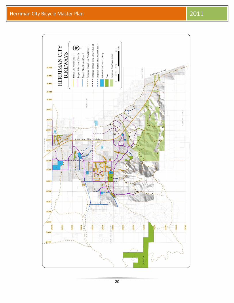
Bikeways Map………………………………………………………………………………………………………………………….20
2
Herriman City Bicycle Master Plan 2011
ACKNOWLEDGEMENTS
Herriman City Council
Mayor Joshua Mills Commissioner Mike Day Commissioner Raquel DeLuca Commissioner Matt Robinson Commissioner Craig Tischner
Herriman Planning Commission Wayne Hill – Chairman Dave Burrows Blayde Hamilton Trevor Hull Sky King Grant Mines Jessica Morton Robyn Shakespear Clint Smith
Project Team Gordon Haight, Community Development Director Bryn McCarty, Planning Supervisor Mark Jensen, Assistant City Engineer Eric Blackett, ITS Technician II Colton Christensen, Planner
3
Herriman City Bicycle Master Plan 2011
EXECUTIVE SUMMARY
The need for alternative modes of transportation is a growing movement and a desired option
for residents across the country. Bicycling is one of those modes as well as a form of exercise
and recreation. Herriman City realizes this and shows its commitment by adopting a Bicycle
Master Plan. The City’s attractiveness for new growth and economic development is based in
large measure to its reputation for recreational facilities. To provide an efficient, safe, and
multi-rider citywide bike system, Herriman City has created and adopted a Bicycle Master Plan.
The bicycle master plan considers the following:
Diversity of skills and abilities
Connections and nodes
Connections to other modes of transportation
Support facilities
Recreational and commuter cycling
Avoidance of barriers
New development opportunities
Street maintenance
Enhancement opportunities
Public education and innovation
Herriman City divides its bike system into three different classes. Class 1 is designated as
“Shared Use Path”, class 2 is designated as “Striped Bike Lane”, and class 3 is designated as
“Signed Bike Route”. In this plan, existing and proposed segments are identified throughout the
City.
Existing mileage of each class:
Class 1 – 26.30 miles, Shared Use Path
o 34.07 miles proposed
Class 2 – 19.53 miles, Striped Bike Lane
o 6.37 miles proposed
Class 3 – 7.13 miles, Signed Bike Route
o 4.92 miles proposed
With a total of 52.96 miles of existing bikeways and the plan identifying an additional 45.36
miles of bikeways within the City, connections to neighboring communities and regional bike
paths can increase.
4
Herriman City Bicycle Master Plan 2011
Adoption of this bicycle master plan will provide Herriman City with the framework to
responsibly develop and continue the expansion of its bike system as well as allow City
resources to be used to develop the plan. A well constructed bicycle master plan will enhance
the quality of life of residents and increase the desirability of the City for generations to come.
5
Herriman City Bicycle Master Plan 2011
PURPOSE
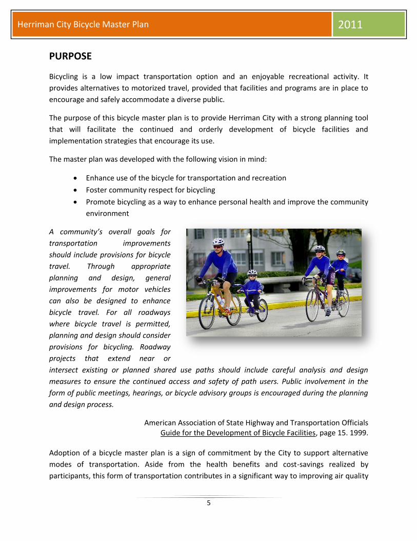
Bicycling is a low impact transportation option and an enjoyable recreational activity. It
provides alternatives to motorized travel, provided that facilities and programs are in place to
encourage and safely accommodate a diverse public.
The purpose of this bicycle master plan is to provide Herriman City with a strong planning tool
that will facilitate the continued and orderly development of bicycle facilities and
implementation strategies that encourage its use.
The master plan was developed with the following vision in mind:
Enhance use of the bicycle for transportation and recreation
Foster community respect for bicycling
Promote bicycling as a way to enhance personal health and improve the community
environment
A community’s overall goals for
transportation improvements
should include provisions for bicycle
travel. Through appropriate
planning and design, general
improvements for motor vehicles
can also be designed to enhance
bicycle travel. For all roadways
where bicycle travel is permitted,
planning and design should consider
provisions for bicycling. Roadway
projects that extend near or
intersect existing or planned shared use paths should include careful analysis and design
measures to ensure the continued access and safety of path users. Public involvement in the
form of public meetings, hearings, or bicycle advisory groups is encouraged during the planning
and design process.
American Association of State Highway and Transportation Officials Guide for the Development of Bicycle Facilities, page 15. 1999.
Adoption of a bicycle master plan is a sign of commitment by the City to support alternative
modes of transportation. Aside from the health benefits and cost-savings realized by
participants, this form of transportation contributes in a significant way to improving air quality
6
Herriman City Bicycle Master Plan 2011
and reducing congestion on city streets. Additionally, the Utah Transit Authority’s current bus
stops generate pedestrian activity. With the proposed future extension of TRAX into Herriman,
pedestrian activity near stations will greatly increase. Since buses and TRAX transport bicycles,
the convenience of transit for bicyclists is enhanced. The bicycle master plan should reflect the
needs of current bicyclists as well as the needs of future users.
BIKEWAY CONSIDERATIONS
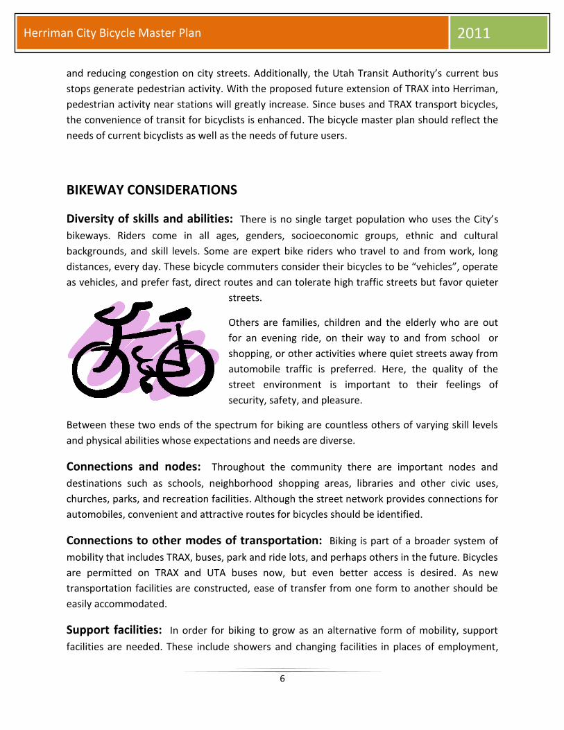
Diversity of skills and abilities: There is no single target population who uses the City’s
bikeways. Riders come in all ages, genders, socioeconomic groups, ethnic and cultural
backgrounds, and skill levels. Some are expert bike riders who travel to and from work, long
distances, every day. These bicycle commuters consider their bicycles to be “vehicles”, operate
as vehicles, and prefer fast, direct routes and can tolerate high traffic streets but favor quieter
streets.
Others are families, children and the elderly who are out
for an evening ride, on their way to and from school or
shopping, or other activities where quiet streets away from
automobile traffic is preferred. Here, the quality of the
street environment is important to their feelings of
security, safety, and pleasure.
Between these two ends of the spectrum for biking are countless others of varying skill levels
and physical abilities whose expectations and needs are diverse.
Connections and nodes: Throughout the community there are important nodes and
destinations such as schools, neighborhood shopping areas, libraries and other civic uses,
churches, parks, and recreation facilities. Although the street network provides connections for
automobiles, convenient and attractive routes for bicycles should be identified.
Connections to other modes of transportation: Biking is part of a broader system of
mobility that includes TRAX, buses, park and ride lots, and perhaps others in the future. Bicycles
are permitted on TRAX and UTA buses now, but even better access is desired. As new
transportation facilities are constructed, ease of transfer from one form to another should be
easily accommodated.
Support facilities: In order for biking to grow as an alternative form of mobility, support
facilities are needed. These include showers and changing facilities in places of employment,
7
Herriman City Bicycle Master Plan 2011
bike racks throughout the City, permanent and secure parking and storage facilities for bicycles,
temporary parking facilities during special events and festivals, service areas, and other similar
uses for bicycles. Additionally, new developers should be educated about the importance of
providing these amenities.
Recreational and commuter cycling: A Bicycle Master Plan should accommodate both
recreational and commuter bicyclists needs. Quieter residential streets that are aesthetically
appealing should be inviting for recreational users. Fast, direct routes on busier roadways
should be provided with continuous bike lanes for commuter users.
Avoidance of barriers: Major arterials, highways, railways, and other manmade structures
are barriers to bicycle use. As new infrastructure is being planned, safe bicycle amenities need
to be integrated into the design.
New development opportunities: As new development and redevelopment projects
occur, facilities for bicyclists should be included in the planning, design, and approval process.
Street maintenance: Bikeways need regular maintenance. Potholes, recessed manholes,
inadequately and poorly repaired roads, drain covers, curb and gutter damage, and other
hazards affect the safety of bicyclists.
Enhancement opportunities: Canal rights-of-way, highway rights-of-way, alleys, stream
corridors, and others are opportunities for off-street biking corridors that should be optimized.
Public education and innovation: Public education is a continuing need, both to educate
motorists about the presence and rights of bicyclists, and to educate bicyclists about the rules
that apply to them involving the safe use of streets. Additionally, other communities, states and
out-of-country locations are trying and succeeding with innovative means of blending multiple
modes of transportation, encouraging bicycle use, and creating an atmosphere and
environment that supports multi-modalism.
BIKEWAY CLASSIFICATIONS
Over the years, the transportation industry has given individual names to differing types of
bicycle facilities. The names provide a simple method to assist in identifying target users and for
generalizing design guidelines. In the United States, the most widely referred to names for
bicycle facilities are those found in The American Association of State Highway and
Transportation Officials (AASHTO) Guide for the Development of Bicycle Facilities (1999), which
8
Herriman City Bicycle Master Plan 2011
Herriman City has adopted for bike designs. AASHTO defines four basic types of bicycle facilities
as follows:
Shared Roadways
Signed Shared Roadways
Bike Lanes
Shared Use Paths
To better suit local needs and based on the AASHTO classifications listed above, Herriman City
has classified bicycle facilities into three general classes:
Shared Use Path (Class 1)
Striped Bike Lane (Class 2)
Signed Bike Route (Class 3)
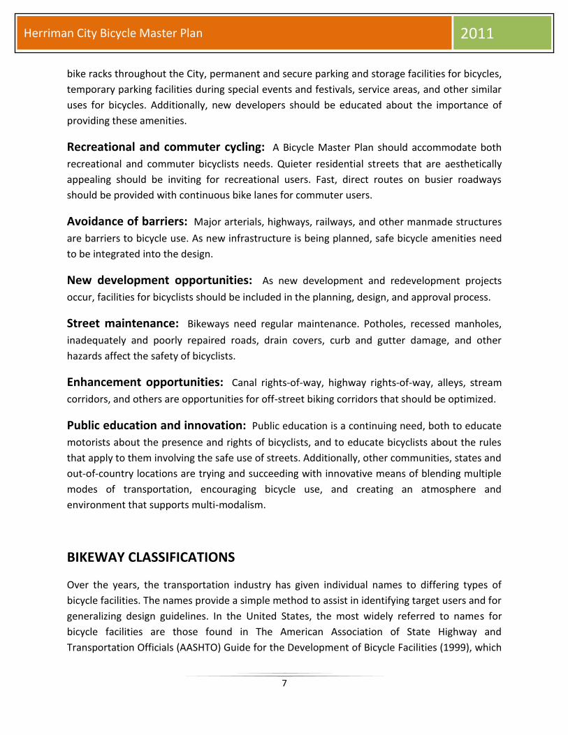
Shared Use Path (Class 1)
Shared use paths are defined as separate trail systems that accommodate a wide variety of
non-motorized users. These are typically found in parks and various open space locations.
Trailheads should be easily accessible and neighborhood connections are encouraged.
Bicyclists, joggers, walkers, and other recreational
users frequent these trails. The paths are generally 8-
12 feet wide, asphalt paved, and signed to minimize
conflicts between different types of users. Where
sufficient right-of-way is available, separate pathways
for bicyclists and pedestrians could be developed.
Existing shared use paths in Herriman total 26.30
miles.
9
Herriman City Bicycle Master Plan 2011
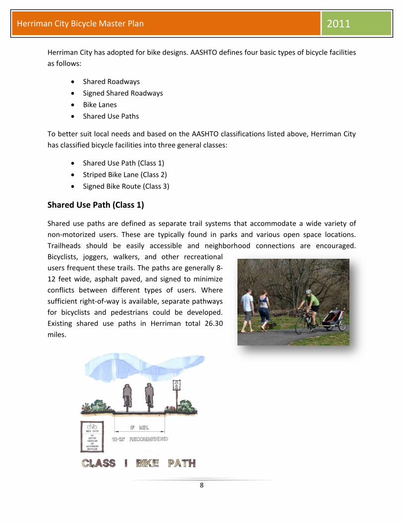
Striped Bike Lane (Class 2)
Two bike lane stripes are utilized to designate
bike lanes adjacent to parking and one stripe
is used on roadways without parking. Bicycle
pavement markings and signs are used to
designate the lanes for exclusive bicycle use.
The bike lanes are generally 4-5 feet wide.
Existing striped bike lanes in Herriman total
19.53 miles.
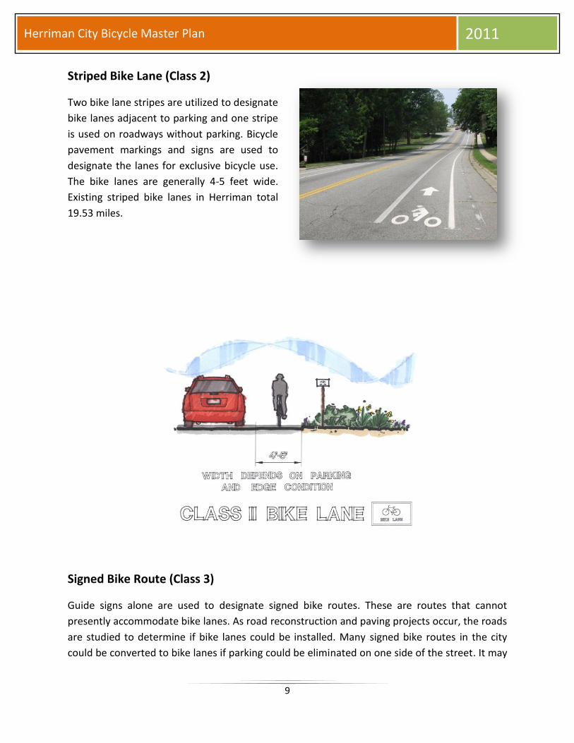
Signed Bike Route (Class 3)
Guide signs alone are used to designate signed bike routes. These are routes that cannot
presently accommodate bike lanes. As road reconstruction and paving projects occur, the roads
are studied to determine if bike lanes could be installed. Many signed bike routes in the city
could be converted to bike lanes if parking could be eliminated on one side of the street. It may
10
Herriman City Bicycle Master Plan 2011
also be possible to reduce the width of travel lanes, eliminate center turn lanes, or eliminate a
motorized vehicle lane. Existing signed bike routes in Herriman total 7.13 miles.
BIKEWAY HIGHLIGHTS
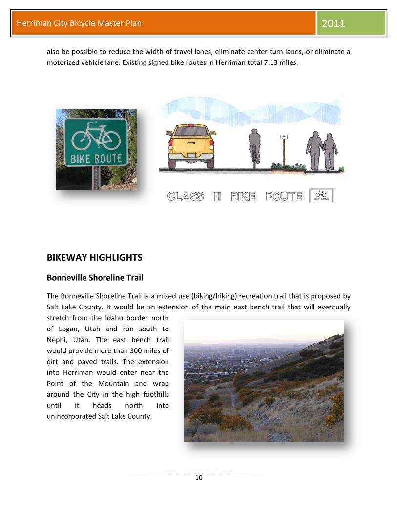
Bonneville Shoreline Trail
The Bonneville Shoreline Trail is a mixed use (biking/hiking) recreation trail that is proposed by
Salt Lake County. It would be an extension of the main east bench trail that will eventually
stretch from the Idaho border north
of Logan, Utah and run south to
Nephi, Utah. The east bench trail
would provide more than 300 miles of
dirt and paved trails. The extension
into Herriman would enter near the
Point of the Mountain and wrap
around the City in the high foothills
until it heads north into
unincorporated Salt Lake County.
11
Herriman City Bicycle Master Plan 2011
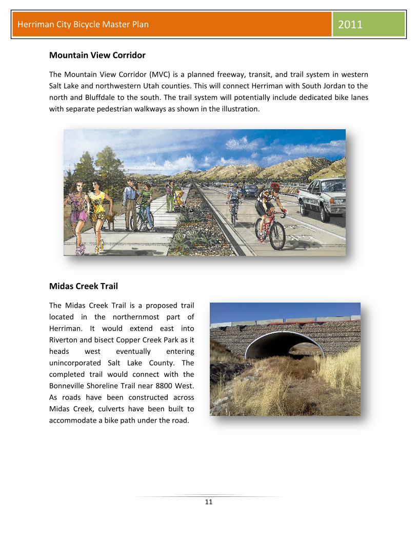
Mountain View Corridor
The Mountain View Corridor (MVC) is a planned freeway, transit, and trail system in western
Salt Lake and northwestern Utah counties. This will connect Herriman with South Jordan to the
north and Bluffdale to the south. The trail system will potentially include dedicated bike lanes
with separate pedestrian walkways as shown in the illustration.
Midas Creek Trail
The Midas Creek Trail is a proposed trail
located in the northernmost part of
Herriman. It would extend east into
Riverton and bisect Copper Creek Park as it
heads west eventually entering
unincorporated Salt Lake County. The
completed trail would connect with the
Bonneville Shoreline Trail near 8800 West.
As roads have been constructed across
Midas Creek, culverts have been built to
accommodate a bike path under the road.

12
Herriman City Bicycle Master Plan 2011
Rose Creek Trail
The Rose Creek Trail is an existing trail located
roughly in the center of Herriman. It runs
through Rosecrest Park and connects east into
Riverton. A proposed extension west into
unincorporated Salt Lake County would connect
the trail with the Bonneville Shoreline Trail.
12600 South
This major arterial connecting Herriman
with Riverton is a vital route for bicyclists,
specifically, bike commuters. In Riverton,
bike lanes currently exist along 12600
South but only extend westward to
Bangerter Highway. This leaves a gap
between the Herriman City boundary and
Bangerter Highway, roughly six blocks.
Collaboration between the two cities on
completing the bike lane should be a
priority.
Welby-Jacob Canal
The Welby-Jacob Canal is a proposed paved path that
would parallel the irrigation canal that runs from the far
southeast corner of Herriman north along the border of
Bluffdale through Riverton and eventually into South
Jordan. Currently, there are “No Trespassing” signs along
the canal so those would have to be removed and
replaced with proper signage. The trail would
accommodate walkers/joggers and bicyclists.
13
Herriman City Bicycle Master Plan 2011
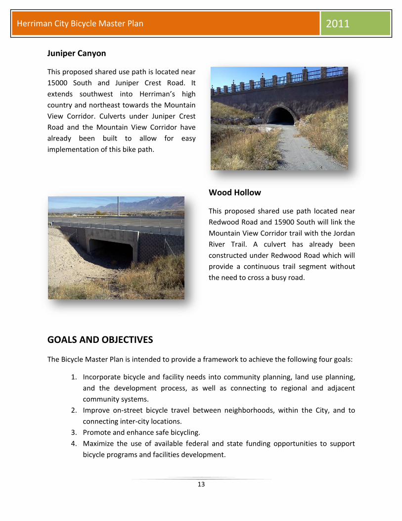
Juniper Canyon
This proposed shared use path is located near
15000 South and Juniper Crest Road. It
extends southwest into Herriman’s high
country and northeast towards the Mountain
View Corridor. Culverts under Juniper Crest
Road and the Mountain View Corridor have
already been built to allow for easy
implementation of this bike path.
Wood Hollow
This proposed shared use path located near
Redwood Road and 15900 South will link the
Mountain View Corridor trail with the Jordan
River Trail. A culvert has already been
constructed under Redwood Road which will
provide a continuous trail segment without
the need to cross a busy road.
GOALS AND OBJECTIVES
The Bicycle Master Plan is intended to provide a framework to achieve the following four goals:
1. Incorporate bicycle and facility needs into community planning, land use planning,
and the development process, as well as connecting to regional and adjacent
community systems.
2. Improve on-street bicycle travel between neighborhoods, within the City, and to
connecting inter-city locations.
3. Promote and enhance safe bicycling.
4. Maximize the use of available federal and state funding opportunities to support
bicycle programs and facilities development.
14
Herriman City Bicycle Master Plan 2011
Goal 1: Incorporate bicycle mobility and facility needs into community planning, land use
planning, and the development process, as well as connecting to regional and
adjacent community systems.
Include a bicycle system element into each small area, neighborhood,
and citywide planning document.
Include bicycle considerations into new development and redevelopment
projects.
Encourage and facilitate bicycle use so that it becomes a viable and
attractive choice for travel within the City.
Goal 2: Improve on-street bicycle travel between neighborhoods, within the City, and to
connecting inter-city locations.
Identify, eliminate, or provide alternatives to physical barriers to bicycles.
Investigate other feasible off-street trail corridors on other publicly and
privately held regional corridors.
Accommodate bicycles on public transportation systems.
Provide support facilities and services to encourage and facilitate bicycle
use.
Coordinate with other state and neighboring local jurisdictions and
potential partner organizations to manage and enhance bicycle
circulation and support facilities at jurisdictional boundaries.
Maintain bicycle facilities in a safe and operational condition.
Goal 3: Promote and enhance safe bicycling.
Provide clear signing and pavement markings targeted to bicyclists,
pedestrians, and motorists.
Educate bicyclists, pedestrians, and motorists concerning bicyclist’s rights
and obligations, as well as about the City’s network of bicycle systems
and classifications.
Goal 4: Maximize the use of available federal and state funding opportunities to support
bicycle programs and facilities development.

15
Herriman City Bicycle Master Plan 2011
CONCLUSION
The Herriman City Bicycle Master Plan is an important tool to successfully implement a bike
system that is inviting for residents as well as a beneficial asset for communities and the entire
City. Additionally, new developments should be designed to accommodate bicycles and
necessary safety features.
As Herriman’s bikeways continue to expand, future consideration for regional and national
bicycle events could be an attractive option. The City’s overall image as a recreationally minded
community would increase and further the desirability of potential residents. A Bicycle Master
Plan provides the proper framework for current needs and future desires all while enhancing
the quality of life of residents.
16
Herriman City Bicycle Master Plan 2011
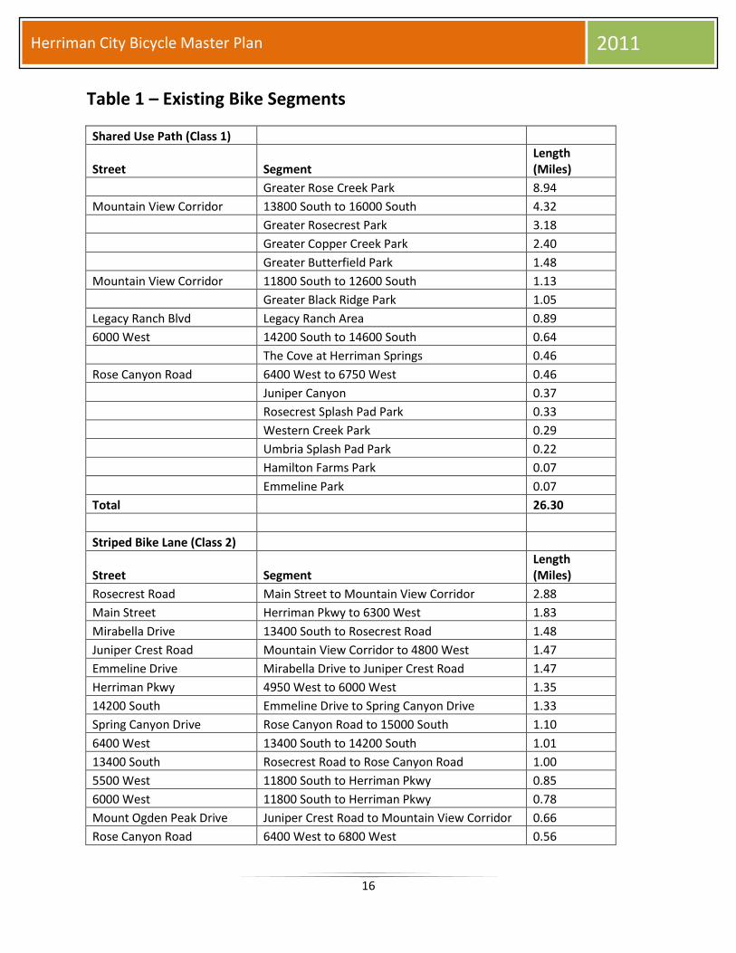
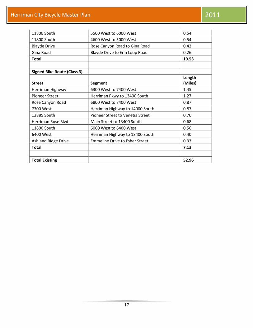
Table 1 – Existing Bike Segments
Shared Use Path (Class 1)
Street Segment Length (Miles)
Greater Rose Creek Park 8.94
Mountain View Corridor 13800 South to 16000 South 4.32
Greater Rosecrest Park 3.18
Greater Copper Creek Park 2.40
Greater Butterfield Park 1.48
Mountain View Corridor 11800 South to 12600 South 1.13
Greater Black Ridge Park 1.05
Legacy Ranch Blvd Legacy Ranch Area 0.89
6000 West 14200 South to 14600 South 0.64
The Cove at Herriman Springs 0.46
Rose Canyon Road 6400 West to 6750 West 0.46
Juniper Canyon 0.37
Rosecrest Splash Pad Park 0.33
Western Creek Park 0.29
Umbria Splash Pad Park 0.22
Hamilton Farms Park 0.07
Emmeline Park 0.07
Total 26.30
Striped Bike Lane (Class 2)
Street Segment Length (Miles)
Rosecrest Road Main Street to Mountain View Corridor 2.88
Main Street Herriman Pkwy to 6300 West 1.83
Mirabella Drive 13400 South to Rosecrest Road 1.48
Juniper Crest Road Mountain View Corridor to 4800 West 1.47
Emmeline Drive Mirabella Drive to Juniper Crest Road 1.47
Herriman Pkwy 4950 West to 6000 West 1.35
14200 South Emmeline Drive to Spring Canyon Drive 1.33
Spring Canyon Drive Rose Canyon Road to 15000 South 1.10
6400 West 13400 South to 14200 South 1.01
13400 South Rosecrest Road to Rose Canyon Road 1.00
5500 West 11800 South to Herriman Pkwy 0.85
6000 West 11800 South to Herriman Pkwy 0.78
Mount Ogden Peak Drive Juniper Crest Road to Mountain View Corridor 0.66
Rose Canyon Road 6400 West to 6800 West 0.56
17
Herriman City Bicycle Master Plan 2011
11800 South 5500 West to 6000 West 0.54
11800 South 4600 West to 5000 West 0.54
Blayde Drive Rose Canyon Road to Gina Road 0.42
Gina Road Blayde Drive to Erin Loop Road 0.26
Total 19.53
Signed Bike Route (Class 3)
Street Segment Length (Miles)
Herriman Highway 6300 West to 7400 West 1.45
Pioneer Street Herriman Pkwy to 13400 South 1.27
Rose Canyon Road 6800 West to 7400 West 0.87
7300 West Herriman Highway to 14000 South 0.87
12885 South Pioneer Street to Venetia Street 0.70
Herriman Rose Blvd Main Street to 13400 South 0.68
11800 South 6000 West to 6400 West 0.56
6400 West Herriman Highway to 13400 South 0.40
Ashland Ridge Drive Emmeline Drive to Esher Street 0.33
Total 7.13
Total Existing 52.96
18
Herriman City Bicycle Master Plan 2011
Table 2 – Proposed Bike Segments
Proposed Shared Use Path (Class 1)
Street/Path Segment Length (Miles)
Bonneville Shoreline Trail 2000 West to 6400 West 6.04
C 4.65
Welby-Jacob Canal 13800 South to Bonneville Shoreline Trail 3.64
F 3.32
D 2.80
E 2.19
Midas Creek Trail 4950 West to 6400 West 2.07
Juniper Canyon 3800 West to 4800 West 1.50
Mountain View Corridor 16000 South to 17000 South 1.39
Butterfield Creek 5600 West to 6600 West 1.37
A 1.06
H 0.96
G 0.85
B 0.64
Rose Creek 6500 West to 7000 West 0.59
I 0.57
J 0.29
7300 West 13200 South to 13300 South 0.14
Total 34.07
Proposed Striped Bike Lane (Class 2)
Street Segment Length (Miles)
Juniper Crest Road 3750 West to 4800 West 1.68
4600 West 13800 South to 14700 South 1.39
13400 South 4800 West to 5600 West 1.00
Rosecrest Road 4000 West to Mountain View Corridor 0.85
5600 West Herriman Pkwy to Main Street 0.77
11800 South 5000 West to 5500 West 0.68
Total 6.37
Proposed Signed Bike Route (Class 3)
Street Segment Length (Miles)
Herriman Towne Center 12700 South to 13400 South 1.55
3600 West Welby-Jacob Canal to Mountain View Corridor 0.80
13600 South 6900 West to 7300 West 0.47
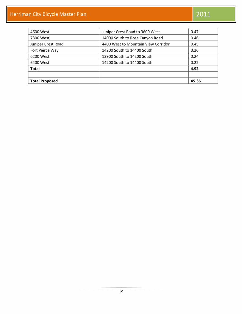
19
Herriman City Bicycle Master Plan 2011
4600 West Juniper Crest Road to 3600 West 0.47
7300 West 14000 South to Rose Canyon Road 0.46
Juniper Crest Road 4400 West to Mountain View Corridor 0.45
Fort Pierce Way 14200 South to 14400 South 0.26
6200 West 13900 South to 14200 South 0.24
6400 West 14200 South to 14400 South 0.22
Total 4.92
Total Proposed 45.36
20
Herriman City Bicycle Master Plan 2011


![HERRIMAN, George - Krazy Kat 1916 [sample pages].pdf](https://img.dokumen.tips/doc/110x75/55cf9b3f550346d033a54c37/herriman-george-krazy-kat-1916-sample-pagespdf.jpg)