Embed Size (px)
Citation preview

THE RELATIONSHIP BETWEEN LAND USE, URBAN FORM AND VEHICLE MILES OF TRAVEL: THE STATE OF KNOWLEDGE AND IMPLICATIONS FOR TRANSPORTATION PLANNING
A White Paper
Prepared for the Florida Department of Transportation BC 353: RPWO: 46
Prepared by Steven E. Polzin, PhD. Center for Urban Transportation Research University of South Florida March 2004
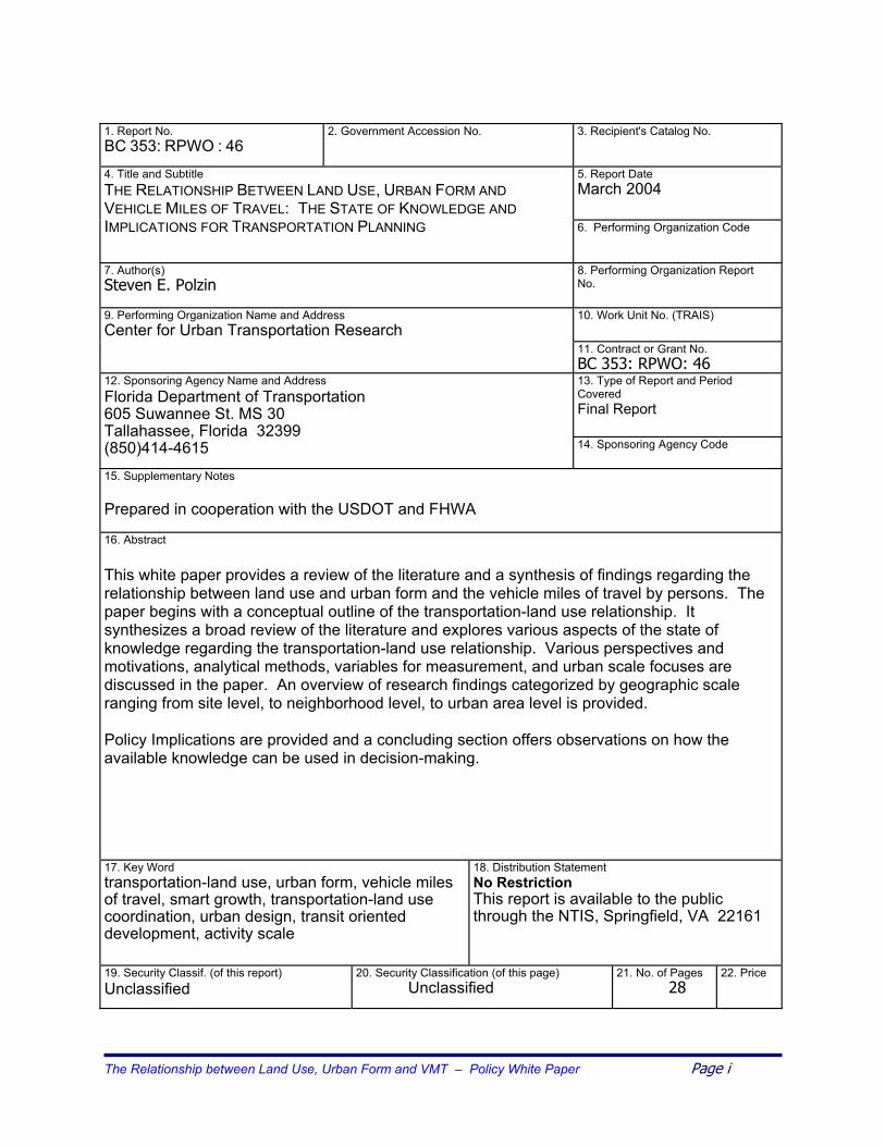
1. Report No. BC 353: RPWO : 46
2. Government Accession No.
3. Recipient's Catalog No. 5. Report Date March 2004
4. Title and Subtitle THE RELATIONSHIP BETWEEN LAND USE, URBAN FORM AND VEHICLE MILES OF TRAVEL: THE STATE OF KNOWLEDGE AND IMPLICATIONS FOR TRANSPORTATION PLANNING
6. Performing Organization Code
7. Author(s) Steven E. Polzin
8. Performing Organization Report No. 10. Work Unit No. (TRAIS)
9. Performing Organization Name and Address Center for Urban Transportation Research
11. Contract or Grant No. BC 353: RPWO: 46 13. Type of Report and Period Covered Final Report
12. Sponsoring Agency Name and Address Florida Department of Transportation 605 Suwannee St. MS 30 Tallahassee, Florida 32399 (850)414-4615 14. Sponsoring Agency Code
15. Supplementary Notes Prepared in cooperation with the USDOT and FHWA
16. Abstract This white paper provides a review of the literature and a synthesis of findings regarding the relationship between land use and urban form and the vehicle miles of travel by persons. The paper begins with a conceptual outline of the transportation-land use relationship. It synthesizes a broad review of the literature and explores various aspects of the state of knowledge regarding the transportation-land use relationship. Various perspectives and motivations, analytical methods, variables for measurement, and urban scale focuses are discussed in the paper. An overview of research findings categorized by geographic scale ranging from site level, to neighborhood level, to urban area level is provided. Policy Implications are provided and a concluding section offers observations on how the available knowledge can be used in decision-making.
17. Key Word transportation-land use, urban form, vehicle miles of travel, smart growth, transportation-land use coordination, urban design, transit oriented development, activity scale
18. Distribution Statement No Restriction This report is available to the public through the NTIS, Springfield, VA 22161
19. Security Classif. (of this report) Unclassified
20. Security Classification (of this page) Unclassified
21. No. of Pages 28
22. Price
The Relationship between Land Use, Urban Form and VMT – Policy White Paper Page i

DISCLAMIMER
The opinions, findings and conclusions expressed in this publication are those of the authors who are responsible for the facts and accuracy of the data presented herein. The contents do not necessarily reflect the views or policies of the Florida Department of Transportation or the U.S. Department of Transportation. This report does not constitute a standard, specification or regulation. The report is prepared in cooperation with the State of Florida Department of Transportation and the U. S. Department of Transportation.
The Relationship between Land Use, Urban Form and VMT – Policy White Paper Page ii

Table of Contents 1 INTRODUCTION..................................................................................................................... 1
Motivations for Understanding the Transportation/Land Use Relationship ...................... 2 Strategies for Understanding VMT ................................................................................... 3
2 PERSPECTIVES ON VMT GROWTH AND CONTRIBUTING FACTORS.......................................... 3
Land Use Definitions ........................................................................................................ 3 Drivers of VMT Growth...................................................................................................... 4 Trip Rates.......................................................................................................................... 6 Trip Length........................................................................................................................ 6 Mode Selection ................................................................................................................. 6
3 Summary of Knowledge about Land Use, Urban Form and VMT ............................... 7
Consensus Conclusions Regarding Transportation–Land Use Relationships.................. 7 Findings from the Literature ............................................................................................. 8 Transportation and Land Use: Site Level.................................................................. 10 Transportation and Land Use: Neighborhood Level ................................................. 10 Transportation and Land Use: Urban Area Level...................................................... 12 Summary of the Literature Review Findings ................................................................... 13
4 POLICY IMPLICATIONS AND OBSERVATIONS ........................................................................ 14
The Motivations of Researchers and Research Sponsors ................................................ 15 Urban Form and Intercity Travel Relationships............................................................... 15 Business Economics and the Transportation-Land Use Relationship ............................ 16 The Future of the Transportation-Land Use Relationship ............................................... 16
5 CONCLUSIONS ................................................................................................................... 17 The Dilemma of Uncertainty ........................................................................................... 17 Which Decisions are Appropriate, Given What We Know? ............................................ 18 Which Decisions Might Not be Prudent, Given the State of Knowledge? ..................... 19
References .......................................................................................................................... 21
List of Tables and Figures Figure 1 Conceptual Model of VMT Growth Drivers ............................................................ 5 Table 1 Outcomes, Questions and Methods in Studies of Urban Form and Travel ............ 9 Figure 2 The Role of Land Use in Mobility Strategies…………………………… ................. 14 Figure 3 Continuum of Land Use Regulation Proactiveness……………………………....... 19 Figure 4 Decision Risk Continuum ..................................................................................... 20
The Relationship between Land Use, Urban Form and VMT – Policy White Paper Page iii
THE IMPACT OF LAND USE AND URBAN FORM ON VEHICLE MILES OF TRAVEL: THE STATE OF KNOWLEDGE AND IMPLICATIONS ON TRANSPORTATION PLANNING
1 INTRODUCTION
Many transportation and land use planners believe that strategies to reduce transportation demand via coordination of land use and transportation planning can contribute to meeting future mobility needs. This premise envisions the land use characteristics of density, mix of uses, urban form, urban design, activity scale, and contiguousness of development, playing a meaningful role in reducing the demand for vehicle travel by reducing vehicle trip frequency, reducing trip lengths, and altering mode choices for travel. Greater success in transportation-land use coordination offers the opportunity to slow the growth of vehicle miles of travel (VMT) and improve livability characteristics of the urban environment. This paper, targeted to professionals and policy makers with an interest in transportation and land use, seeks to explore the impact of land use and urban form on VMT and synthesize the state of knowledge and implications on transportation planning. This is accomplished by reviewing the theories and literature on the transportation-land use relationship and presenting findings and observations about what is known and what remains to be fully explored. There is a growing interest in leveraging the transportation-land use relationship both as a result of the growing deficit in transportation capacity and in response to a growing body of data on growth management and urban design strategies and their impacts. Recent reports such as the 2002 Status of the Nation's Highways, Bridges, and Transit: Conditions & Performance Report to Congress, portray declining performance for transportation infrastructure and indicate an inability for capacity expansion to keep pace with growing demand (1). These and similar studies such as The 2003 Annual Urban Mobility Report, as well as local transportation studies, anecdotal evidence, and personal observation confirm the supply and demand imbalance (2, 3). The consequences of various urban development and design strategies have been of interest for several decades. In the 1970’s there were initiatives to understand this relationship from the perspective of energy use implications of urban development and transportation network patterns. “Gasoline Consumption and Cities,” in the Journal of the American Planning Association (1989), provided empirical data on energy use for urban areas across the globe (4). The original Cost of Sprawl study by the Real Estate Research Corporation initiated the ongoing discussions of the cost of sprawl (5). The 1990’s saw a heightened interest in the relationship between urban form and transportation needs. The growing investment in transit systems, increasing levels of congestion, concerns about global warming and the environment, and an inability to identify acceptable transportation investments and adequate resources to keep pace with growing travel demand spurred interest in longer-term development and design solutions for moderating the growth of travel demand. Travel by Design: The Influence of Urban Form on Travel reports on the state of knowledge (6). The Relationship between Land Use, Urban Form and VMT – Policy White Paper Page 1

Land Use and Site Design, Traveler Response to Transportation System Changes (TRCP Report 95, Chapter 15) provides a comprehensive overview of research results regarding the effects of land use on transportation with particular attention to discerning quantitative measures of the relationships (7). The major variables describing land use around which the report was organized were density, diversity (mix of uses) and design. This report provides a powerful perspective on both the complexity of the subject and research challenges associated with defining, quantifying, and disaggregating the numerous factors that collectively influence travel behavior. The complex social, technical, and political nature of the transportation-land use relationship, combined with evolving culture, values, and technologies, results in a complex and dynamic set of interrelationships that are not yet fully understood. Motivations for Understanding the Transportation-Land Use Relationship There are two basic premises that underlie the interest in developing a richer understanding of how land use influences transportation and VMT. First, the transportation planning profession has an interest in understanding the relationship in order to respond to the technical needs of the planning process. This includes a need to forecast future travel demand where land use is a fundamental influencing factor. Similarly, the transportation planner has to be able to estimate the impacts of various transportation investments on land use. In these contexts, the motivation is one of desiring to support efforts to enhance predictive capabilities. Second, a significant consideration in land use planning and transportation investment and policy decisions deals with understanding how changes in either transportation or land use can be used as a tool to influence the other. How can land use be changed to influence performance of the transportation system, and how can the transportation system be developed to encourage a desired land use? In one case, transportation is envisioned as a tool used to influence land use; in the other, land use is a tool to influence transportation. In both instances, the interest is in being prescriptive. Understanding the transportation-land use relationship has implications to a host of both short-and long-range transportation and land use investment and policy decisions. For example, transportation impact fee assessments are often sensitive to the nature and location of the development, and everything from parking standards to external trip production rates used to reflect land use mix in developments are influenced by the transportation-land use relationship (8). Perhaps more significant, major investment and policy decisions with long-term implications are regularly being made premised on varying levels of information or perceptions of how land use and transportation relate. Many aspects of land use regulation, smart growth initiatives, and urban and site design are premised on leveraging the transportation-land use relationship to influence travel demand and quality of life. As noted by Robert Skinner, “The timeless debate about the interaction between transportation and land use continues today but increasingly that debate is less about transportation or land use per se and more about how the combination of the two affects environmental quality, economic growth, and social equity. When viewed in this context, the interaction becomes more important and considerably more complex.” (8) The Relationship between Land Use, Urban Form and VMT – Policy White Paper Page 2

Strategies for Understanding VMT This paper provides a synthesis and insight into the state of knowledge about the transportation-land use relationship. The specific focus is on the linkage between land use, urban form, and VMT. VMT is the measure of interest because it is the principal indicator of transportation demand, as vehicle travel is the vastly dominant means of travel for both persons and commodities. Section two provides a brief overview of the full range of factors that contribute to VMT and VMT growth. The focus then shifts to a conceptual model of the transportation-land use relationship. Subsequent sections report what the literature says about land use and VMT. The final sections of this paper address policy implications and conclusions regarding this body of knowledge.
2 PERSPECTIVES ON VMT GROWTH AND CONTRIBUTING FACTORS
Land Use Definitions The following land use characteristics are linked to trip making and VMT.
• Development density or intensiveness: Development density is measured with various parameters such as population or employment density, square footage of development or intensiveness of economic activity. Measures of density can be applied at various geographic scales. Independent of other factors, higher density and/or intensity creates higher total travel demand from a given geographic zone but enables and encourages shorter auto trips and higher walk, bike, and transit use due to the concentration of activities.
• Mix of uses: Within a given area of land, the mix of uses influences the extent to which
personal activity needs such as work, school, shopping, etc., can be served by development in the area. Mixing of compatible land uses enables shorter trips where bike and walk may be viable options and enables shorter auto trips and supports efficient transit operations.
The Relationship between Land Use, Urban Form and VMT – Policy White Paper Page 3
• Urban form: The broad overall physical geographic arrangement of land-use and transportation facilities determines the urban form. Urban form embraces a host of characteristics that impact the comfort, speed, cost, convenience, attractiveness, and safety of movement between activities. Urban form encompasses the nature of the transportation networks, whether grid, radial, or other, as well as the configuration of land use such as monocentric versus polycentric. Urban form can favor one mode over others and may influence overall VMT by changing the impedance or cost of travel. For example, pedestrian-friendly employment and activity centers connected by moderate to higher density corridors can encourage walking, bicycling, and transit use relative to auto oriented centers isolated from low density residential areas.

• Urban Design: The more detailed physical aspects and relationships of the urban form
are usually referred to as the urban design or site design. The orientation of the building on a site relative to transportation infrastructure (parking sidewalks, bus stops, etc.) can impact the choice of modes. Other design features such as covered walkways, seating, or other amenities can be part of site design. Collectively, these design features can increase the safety, attractiveness, and convenience of various modes. When urban design is targeted to favor walk, bike, and transit services, it can help reduce VMT.
• Activity scale: This factor refers to the scale of the activity at a given location and
determines the size of the market area served by the facility. Larger-scale facilities also require larger land parcels and tend to result in locations on the edge of the built area. Activity scale is determined by the business model for economic functioning of a given land use. Larger facilities tend to result in longer access trips and reduced probability of using walk and bike modes, thus producing greater VMT.
• Contiguousness of development: As areas grow, the edge of the developed area is
very irregular as various landowners choose different times to convert their vacant or agricultural land to developed purposes. It is common, particularly at the outer edges of developed areas, to see a significant mix of undeveloped land interspersed with pockets of development. The skipped-over undeveloped land usually makes alternative transportation unworkable and requires all external trips to or from the new development to be in motor vehicles, thus producing longer auto trips that increase VMT.
Collectively, these features characterize the relationship between land use and travel demand. Most research addresses a subset of these features and density and mix of activities appear to be the most frequently referenced in the literature. Activity scale is perhaps the least frequently considered. Drivers of VMT Growth Between 1977 and 2001, total domestic person travel VMT has grown by 151 percent, according to travel survey data and 110 percent according to field measures (9, 10). During this same time period, national population grew by 30 percent. Thus, only approximately 30 percent of VMT growth is attributable to population growth. The remaining growth is attributable to a host of other factors that contribute to VMT rates per capita. In addition to land use characteristics, these factors include population age profile, auto availability, licensure rates, household size, shared ride propensity, transit use propensity, walk propensity, male and female labor force participation, real income per capita, auto availability and others. An awareness of the contributions of each of these factors to the growth in VMT provides perspective and a greater opportunity to understand the impact of land use changes relative to other changes that also influence VMT levels and growth.
The Relationship between Land Use, Urban Form and VMT – Policy White Paper Page 4

Over the past few decades, urban areas experienced significant changes in land use, including changes in development patterns. The continuing growth in the suburbs is the predominant characterization of urban growth, with Commuting in America II reporting that suburban population grew from 23 percent of total population in 1950 to 47 percent in 1990, with non-metro and central city shares declining (11). Similarly, dispersion to the suburbs has not been limited to population, as in 1990; approximately 41 percent of jobs had also located in areas classified as the suburbs, with 65 percent of job growth in the 1980 to 1990 period being in the suburbs (12). Average VMT growth rates for total person travel have slowed significantly to where the annual VMT growth rates are below 2 percent (13). However, VMT growth rates remain approximately twice the rate of population growth. Figure 1 portrays factors that are known to contribute to VMT (13). This conceptual model categorizes underlying factors into three major areas: social economic factors, land use factors, and transportation system factors. These areas interact with each other and each influences travel behavior in different ways. Land use is one among many factors that are influencing the overall demand for vehicle travel.
Figure 1 Conceptual Model of VMT Growth Drivers
Indirect Drivers of Travel Behavior Changes and VMT Growth
• • Culture/Values
• Cost • •
o Vehicle Miles
f Travel
Transportation System Modal Availability Modal Performance
Speed/Congestion Safety, Reliability, Convenience, etc.
Land Use Density Mix Urban Form Urban Design Activity Scale Contiguousness
Socio-Economic Conditions Household/Person Characteristics
Economic Conditions
Business Conditions Direct Drivers of
VMT Growth Travel Demand
Population 1. Trip Rates 2. Trip Length
Trip Distribution Route/Path
3. Mode Selection
Focusing more closely on the direct drivers of VMT, total population is independent of land use or urban design considerations, but each of the remaining factors -- trip making, trip distribution, mode selection, and travel route or path -- could be influenced by land use considerations as
The Relationship between Land Use, Urban Form and VMT – Policy White Paper Page 5
well as by other factors. For example, the presence of accessible retail opportunities may generate additional shopping trips. Immediately adjacent or nearby retail opportunities may result in shorter shopping trip lengths. Very nearby destinations may result in the decision to walk versus making a vehicle trip, and the presence of sidewalks or other environmental characteristics may influence the choice of the travel path.
VMT is a product of the number of persons, number of trips, trip length including the impact of trip path, and mode choice. Trips, trip length, mode choice, and trip path have a relationship to land use, as land use characteristics have long been known to be factors in decision-making with respect to each of these aspects of travel. However, each is also affected by a variety of other factors such as household and socio-economic conditions that are arguably independent of land use and urban form.
Trip Rates – Between 1977 and 2001, U.S. per capita trip rates increased by 49 percent. This factor is the largest single contributor to increased VMT. Greater participation of women in the workforce, rising real incomes, increased opportunities for travel associated with larger urban areas, and auto availability have played a major role in per capita trip rate growth. Trip Length -- Person miles of travel per person trip is the usual measure of trip length. Average trip length has increased, from slightly less than 9 miles to slightly less than 10 miles in the 1977 - 2001 time period. This 10 percent increase partially explains increases in VMT. This increase in trip lengths is consistent with the expectations that suburbanization is resulting in longer trip lengths. Growth in urban area size, irrespective of other factors would be expected to increase trip length. Low densities and segregation of uses - conditions commonly associated with suburbanization - would exacerbate that tendency. Trip length is influenced by the choice of travel path, which is a function of the connectivity of the network and the attractiveness of the route. Less dense transportation networks, circuitous network designs as might be typical in a suburban area, and unappealing conditions such as unsafe pedestrian environments or congested links influence the respective modes’ trip paths. Mode Selection -- The transportation and land use relationships affect the mode choice of travelers. Mode shift to single-occupant auto accounts for approximately 17 percent of VMT growth between 1977 and 2001. Thus, changes in land use, urban form, and urban design over the last half century might be expected to explain a significant part of the changes in mode choice. One of the sources for growth in VMT has been the shift to drive alone -- the leading trip type. While changes in land use, urban form, and urban design are inevitably contributing factors to the changing mode share during this time period and before, a host of other factors, from increased auto availability to personal safety concerns to a greater sensitivity to the speed of travel, have also influenced mode choice. In addition to land use and urban form changes influencing VMT levels, a host of socio-demographic, economic, business, and cultural trends also played a role in the changes.
The Relationship between Land Use, Urban Form and VMT – Policy White Paper Page 6

Dramatic increases in female labor force participation, rapid increases in vehicle availability, growing real incomes, the aging of the baby boom generation into their peak travel years, increased health, wealth, and auto availability for older Americans, and the supersizing of schools, churches, and retail establishments are among the factors that have also contributed to growing VMT.
3 Summary of Knowledge about Land Use, Urban Form and VMT
Consensus Conclusions Regarding Transportation-Land Use Relationships While exploration and quantification of the transportation-land use relationship continues, there are some conclusions about the six aspects of land use covered in this paper about which there is a relatively strong consensus. All other things held constant, higher development density or intensiveness is more supportive of a viable transit alternative and enables more activities to be served with shorter auto trips or walk and bike modes of travel. Density is correlated with a host of other travel behavior influencing factors such as transit availability, income, auto availability and operating/parking cost, centrality of location, and urban design features including pedestrian amenities. The quantification of density’s impact on VMT is thus highly variable depending upon which factors are controlled for in the analysis. The savings in VMT may not translate into a saving in travel time as non-auto modes are often slower and higher congestion levels can confront auto travelers. Elasticity of travel with respect to density alone appears to be modest; suggesting a multi-element strategy for influencing VMT would be most effective. Both residential density and activity or employment density are important to travel behavior. A mix of uses can enable more activities to be served by shorter trips. The nature of the activity and the nature of the “mixing” of uses may influence the travel response. The scale of geography and socio-demographic match between the residential population and the activities provided in the mix of land uses is relevant to the magnitude of the travel benefit of mixing uses. Mixing of uses can facilitate trip chaining, further impacting travel demand. Job-housing balance is most beneficial if there is balance in income distribution and in the temporal development of the housing and employment opportunities. Urban form characteristics are clearly factors in travel behavior and VMT. The nature of the transportation network can influence travel circuity and the pattern of development can influence the viability of transit and other modes and the length of trips. Urban form influences accessibility, which is unquestionably a factor in travel behavior. Optimality regarding the pattern of the network and development is less well understood, dynamic as an area changes its size, and subject to changes as a function of travel cost, technology, social values and other factors. Transportation sensitive urban design offers an opportunity to make property more
The Relationship between Land Use, Urban Form and VMT – Policy White Paper Page 7

accessible for alternative modes while providing aesthetic, safety and other benefits. These benefits on overall travel behavior are difficult to evaluate in isolation and are not always without potential tradeoffs in cost, convenience, perceived safety and other factors. The influence on VMT of activity scale has been under-appreciated. If the size of the economically viable operation for a school, store, hospital, or other function continues to increase, it can offset the benefits of other land use strategies in minimizing the need for travel. More contiguousness of development can reduce VMT but only applies within the boundary of the developed area. Caution is required as regulating contiguousness of development can cause jurisdictional and legal challenges and has been known to have unintended consequences such as leapfrogging of development to more distant unregulated areas. Absent those unintended consequences, contiguousness will increase density in the study area and reduce travel. Strategies to support more contiguous development can also have benefits with regard to other infrastructure costs, habitat preservation, and efficiencies in service delivery. Findings from the Literature
The body of literature on the transportation-land use relationship has evolved from a variety of disciplines and been motivated by a host of considerations. In addition to the prescriptive and predictive perspectives mentioned earlier, motivations for investigating the relationship between land use and travel range from traditional research motivations to seek greater understanding, to initiatives associated with energy consumption, air quality, environment and habitat, agricultural land preservation, infrastructure cost, social equity and quality of life, and business development. The diversity of interests has attracted a diverse set of disciplines including planners, engineers, economists, statisticians, geographers, anthropologists, public administrators, political scientists, and others with an interest in the science and politics of urban development and transportation. The nature of investigations has ranged from anecdotal commentary, to multi-year comprehensive data mining with statistical analysis tools, to simulation studies. Various authors have classified studies as exemplified in Table 1. The “travel outcomes measures” column identifies possible measures of travel demand. The second column references the characteristics or features of land use about which the authors organized information. This contrasts with the list in Figure 1 that includes development density, mix of uses, urban form, urban design, activity scale, and contiguousness of development referenced as relevant features of land use that have transportation consequences. As one reviews these sets of measures, it is readily apparent that definition and measurement issues are a challenging consideration in quantitative research to explore this relationship. Column three notes different types of research methodologies that have been used. They vary from the rigorous comprehensive statistical analyses and complex simulations to simple case studies and collections of anecdotal data and perceptions. Each has its place and all are well represented in the literature. Examples of the three major types of studies include descriptive
The Relationship between Land Use, Urban Form and VMT – Policy White Paper Page 8
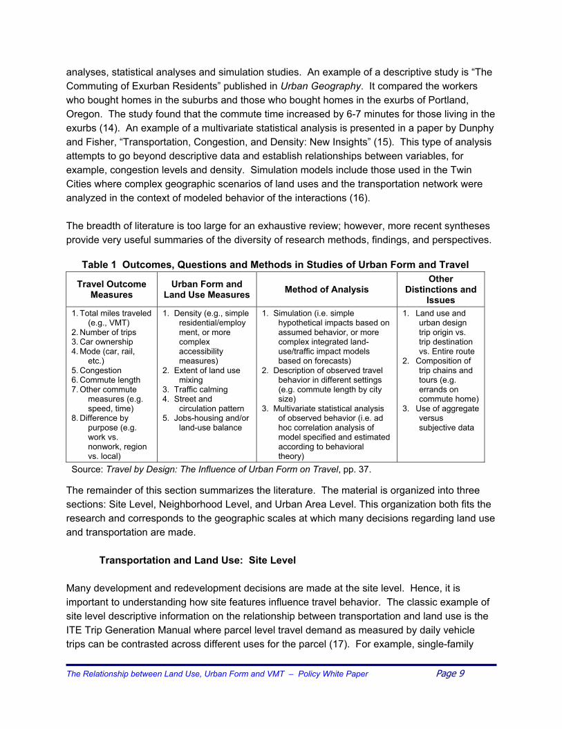
analyses, statistical analyses and simulation studies. An example of a descriptive study is “The Commuting of Exurban Residents” published in Urban Geography. It compared the workers who bought homes in the suburbs and those who bought homes in the exurbs of Portland, Oregon. The study found that the commute time increased by 6-7 minutes for those living in the exurbs (14). An example of a multivariate statistical analysis is presented in a paper by Dunphy and Fisher, “Transportation, Congestion, and Density: New Insights” (15). This type of analysis attempts to go beyond descriptive data and establish relationships between variables, for example, congestion levels and density. Simulation models include those used in the Twin Cities where complex geographic scenarios of land uses and the transportation network were analyzed in the context of modeled behavior of the interactions (16). The breadth of literature is too large for an exhaustive review; however, more recent syntheses provide very useful summaries of the diversity of research methods, findings, and perspectives.
Table 1 Outcomes, Questions and Methods in Studies of Urban Form and Travel
Travel Outcome Measures
Urban Form and Land Use Measures Method of Analysis
Other Distinctions and
Issues 1. Total miles traveled
(e.g., VMT) 2. Number of trips 3. Car ownership 4. Mode (car, rail,
etc.) 5. Congestion 6. Commute length 7. Other commute
measures (e.g. speed, time)
8. Difference by purpose (e.g. work vs. nonwork, region vs. local)
1. Density (e.g., simple residential/employment, or more complex accessibility measures)
2. Extent of land use mixing
3. Traffic calming 4. Street and
circulation pattern 5. Jobs-housing and/or
land-use balance
1. Simulation (i.e. simple hypothetical impacts based on assumed behavior, or more complex integrated land-use/traffic impact models based on forecasts)
2. Description of observed travel behavior in different settings (e.g. commute length by city size)
3. Multivariate statistical analysis of observed behavior (i.e. ad hoc correlation analysis of model specified and estimated according to behavioral theory)
1. Land use and urban design trip origin vs. trip destination vs. Entire route
2. Composition of trip chains and tours (e.g. errands on commute home)
3. Use of aggregate versus subjective data
Source: Travel by Design: The Influence of Urban Form on Travel, pp. 37. The remainder of this section summarizes the literature. The material is organized into three sections: Site Level, Neighborhood Level, and Urban Area Level. This organization both fits the research and corresponds to the geographic scales at which many decisions regarding land use and transportation are made.
Transportation and Land Use: Site Level Many development and redevelopment decisions are made at the site level. Hence, it is important to understanding how site features influence travel behavior. The classic example of site level descriptive information on the relationship between transportation and land use is the ITE Trip Generation Manual where parcel level travel demand as measured by daily vehicle trips can be contrasted across different uses for the parcel (17). For example, single-family
The Relationship between Land Use, Urban Form and VMT – Policy White Paper Page 9

development generates 10 vehicle trips per day per dwelling unit versus approximately 4 vehicle trips per dwelling unit per day for high-density apartment dwellings. Other research looks at how for a given site, other aspects of design can influence travel behavior. For example, work by Reid Ewing has attempted to discern if there are measurable differences in mode choice at the site level based on the presence of attractive pedestrian scale features on the site (18). This research was unable to prove that site level features were significant due to an inability to control for all of the other factors that affect mode choice. Yet, passenger feedback regularly verifies the importance of shelter and amenities for pedestrian and transit travel. Other site level transportation parameters that are known to affect travel demand include parking supply/cost and access design. Parking, in particular, is acknowledged to be a critical factor in mode choice and a substantial body of literature exists on the influence of parking on travel behavior (19). A growing body of material provides urban design guidance that includes elements that apply at the site level. These design principles, often classified as transit or pedestrian friendly designs, are intended to influence the treatment of access by various modes with specific attention to increasing the attractiveness of walk, bike and transit access. These design principles, while contributing to conditions that may reduce VMT, are motivated by a variety of factors including safety, aesthetics, and mobility for the disadvantaged; thus, their relevance is not tied exclusively to their ability to alter overall travel demand or VMT. Examples of design guidance include documents issued by various governmental agencies and professional organizations (20-23). While current research suggests that it is difficult to quantitatively isolate the impacts of site level design features on travel behavior, our knowledge of mode choice behavior, stated preference data, and market responses support continued developments in this area (24).
Transportation and Land Use: Neighborhood Level The neighborhood, station area or planned development scale of geography has received a great deal of attention. At this scale, the land use features of density, urban design, site design, and land use mix all become relevant to the planner. This scale is of particular interest as it is coincident with many planned unit developments and many urban redevelopment initiatives or station area land use planning initiatives. This scale of development also is important because it typically requires land planning integration with transportation network planning and involves collaboration between the private sector that often controls the site level decisions, with the public sector that has a role in comprehensive land use planning and zoning and infrastructure provision. Most often, studies at this level of geography focus on the relative travel demands generated by different development designs. Samples of research at this scale include numerous studies that relate to the mix of land uses, the nature of the roadway network and the extent to which design focuses on leveraging the availability of transit services. Toole-Holt summarizes the work of various researchers (25), including Robert Cervero, Reid Ewing, Lawrence Frank, Gary Pivo and Susan Handy, who have
The Relationship between Land Use, Urban Form and VMT – Policy White Paper Page 10

studied how various spatial designs affect various measures of travel demand (26-28). Many of these studies have considered smart growth or neo-traditional neighborhoods. Susan Handy’s work in this area suggests that research regarding the impact of these neighborhoods can be divided into three groups: traditional transportation models that compare typical suburban designs with hypothetical neo-traditional neighborhood designs; aggregate level data used to compare cities with different designs or densities; and disaggregate level data used to test differences in an individual’s travel choices in different neighborhoods (29). According to Handy, results from the first two methods generally confirm claims that neo-traditional neighborhoods generate fewer automobile trips and shorter trip distances. Nevertheless, by using the third type of analysis, the results may depend on factors that are not accounted for in the first two types. These factors include individual or household characteristics, such as income, age, household type, auto availability, etc. Results show that fewer automobile trips in neo-traditional neighborhoods imply lower total daily travel times by automobile, but, when transit, walk, and other non-motorized modes are included, total travel time may be greater than traditional suburban neighborhoods. One study that exhibited such results concentrated on Seattle (30). This study used travel diaries from persons living in neo-traditional neighborhoods and compared the data with other individuals in the region. According to the results, residents of mixed land use or neo-traditional neighborhoods in Seattle traveled 28 percent fewer miles than residents in adjacent areas and well below the miles of residents in suburban areas (30). This trend occurred regardless of socioeconomic characteristics. When total travel time expenditures were considered, differences between various area types were not apparent. According to this study, daily travel time was about 90 minutes per person regardless of location or socioeconomic characteristics. “Travel and the Built Environment” by Reid Ewing and Robert Cervero is a synthesis of existing literature on land use-travel relationships (31). Studies focus on a variety of measures, including trip frequencies, trip lengths, mode choice or modal split, person miles traveled (PMT), vehicle miles traveled (VMT), and vehicle hours traveled (VHT). Each study included in the synthesis varied in methodology, survey area and results. Some of the results indicated that transit trip rates increased with densities. VMT is lower in households in higher densities. Higher densities induce more walk and bike trips, and VHT is lower in areas with high household density and high employment density (31). Land Use and Site Design, Traveler Response to Transportation System Changes, Chapter 15, TCRP Report 95 includes sections on density, diversity (mix) and design (7). This comprehensive report classified findings into three major categories, density, diversity (mix) and design and provides a comprehensive summary of the range of empirical findings. Another rapidly growing area of interest relating to neighborhood level development and travel is referred to as transit oriented development. Transit Oriented Development (TOD) is a systematic way of thinking about how land development in proximity to transit can be designed in a manner that leverages the presence of transit while providing other quality of life benefits to The Relationship between Land Use, Urban Form and VMT – Policy White Paper Page 11

the community and residents. The burgeoning body of literature on this subject is documented in texts such as The New Transit Town: Best Practices in Transit-Oriented Development and on various web sites (32-36). The Florida Department of Transportation recently completed a report providing guidance on design of Multimodal Transportation Districts, titled, “Multimodal Transportation Districts and Areawide Quality of Service Handbook” (37). Another recent example is Creating Great Neighborhoods: Density in Your Community, U.S. EPA, sponsored by the National Association of Realtors (38). These and other studies of neighborhood-level relationships between transportation and land use offer a wealth of information, provide a variety of perspectives, and offer various measures of transportation consequences of neighborhood level land use and urban form characteristics. There is growing interest in smart growth characteristics at the neighborhood level and evolving research linkages between health and obesity, security, and personal safety as a function of neighborhood level development characteristics. The single largest risk to transferability of findings from neighborhood level studies relates to the self-selection aspect of residents in areas with specific design features. There may be a systematic self selection preference or predilection of those who choose to live in these environments resulting in a willingness to behave differently with respect to travel behavior than might be the case if the specific land use features or elements were applied in more applications, thus, potentially overstating the possible VMT minimizing influence of the specific urban form characteristics. Nonetheless, theory, research, and personal experiences confirm both the opportunity to minimize travel via transportation-land use coordination at the neighborhood level and the reality that such neighborhoods are producing less VMT.
Transportation and Land Use: Urban Area Level The third general category of urban scale is the urban area level. Urban areas embrace the full range of land use characteristics including size, development density, mix of uses, urban form, urban design, activity scale and contiguousness of development. Between urban areas, variations in the range of socio-demographic conditions are narrower and one would expect the variation in transportation output measures to be more moderate reflecting the narrowing of differences across contexts. The relevance of results at this scale of analysis is also different. The time frame for influencing urban area land use characteristics is far longer and a jurisdiction’s governance, topographic features and other intangibles begin to influence the abilities of plans and policies to have impact at the aggregate scale. Nonetheless, these types of comparisons give a relevant perspective of the relative magnitude of influence that can be expected at the urban or regional scale. Historically, descriptive cross-urban area comparisons include the classic work by Kenilworth and Newman that looked at aggregate transportation consumption in contrast to gross urban area land use measures such as population density (39). Other, older urban area scale work includes the work of Gordon and Richardson, who used aggregate measures to predict transit The Relationship between Land Use, Urban Form and VMT – Policy White Paper Page 12

mode share as a function of eight variables inducing some measures of land use (40). Newer work includes Miller and Ibrahim’s analysis of urban form and vehicular travel (41) and Holtzclaw’s review of using residential patterns and transit to decrease auto dependence and costs (42). Some of the most exciting work on land use is the evolving field of urban land use simulation where far more complex models of land use and infrastructure are being developed to explore alternative futures in terms of how various development patterns impact transportation demands and infrastructure requirements. The first high profile study of this type was the Oregon LUTRAQ study. More recently, the Twin Cities in Minnesota have developed a comprehensive model to help them explore the consequences of alternative land use patterns (16). Such methods are dependent on both how well actual travel behaviors have been captured by the models as well as how stable these relationships and behaviors will be over time. They, nonetheless, provide an appealing ability to aggregate impacts at the regional scale where they can support policy decisions. The Twin Cities study of alternative future development scenarios produced a range of VMT levels for the whole urban area that differed by 17 percent in the design year. Another example of investigation at the metropolitan area level is the study of the connection between a jobs-housing balance and reduced travel (43). Researchers have employed several techniques including gravity models, discrete choice models, entropy indexes, and the Lorenz Curve. Cervero found that a severe jobs-housing imbalance tends to correlate with high levels of congestion on connecting freeways and is a significant explanatory factor in residential location choice (44). Wachs et al. found little evidence to support the argument that jobs-housing imbalance increases commuting distance and time (45). Giuliano et al. found that jobs-housing balance has a statistically significance, but not a very large influence on actual commuting times (46). This contrasts with studies at the micro level (census block or self contained small township) that indicate a strong relationship of VMT reductions and job-housing balance (47). Other analyses carried out at the urban area level have focused on transit mode share, urban density, CBD concentration, and roadway network intensiveness among others. Urban area comparisons are supported by more standardized databases and enable studies to include comparisons with international cities (48). Summary of the Literature Review Findings The breadth of research provides a huge range of perspectives on the transportation-land use relationship and offers the reader a wealth of knowledge but often raises as many questions as it answers. In general, the newer research offers more sophisticated methods and more careful specification of research designs. Various strategies for classifying the literature or comparing numerical results offer insight, however, adequate specification of context and qualifications The Relationship between Land Use, Urban Form and VMT – Policy White Paper Page 13
makes it difficult to generalize and summarize findings. The collective body of evidence does provide the user with a sense of both the factors of relevance and the range of the magnitude of the changes that might be affected.
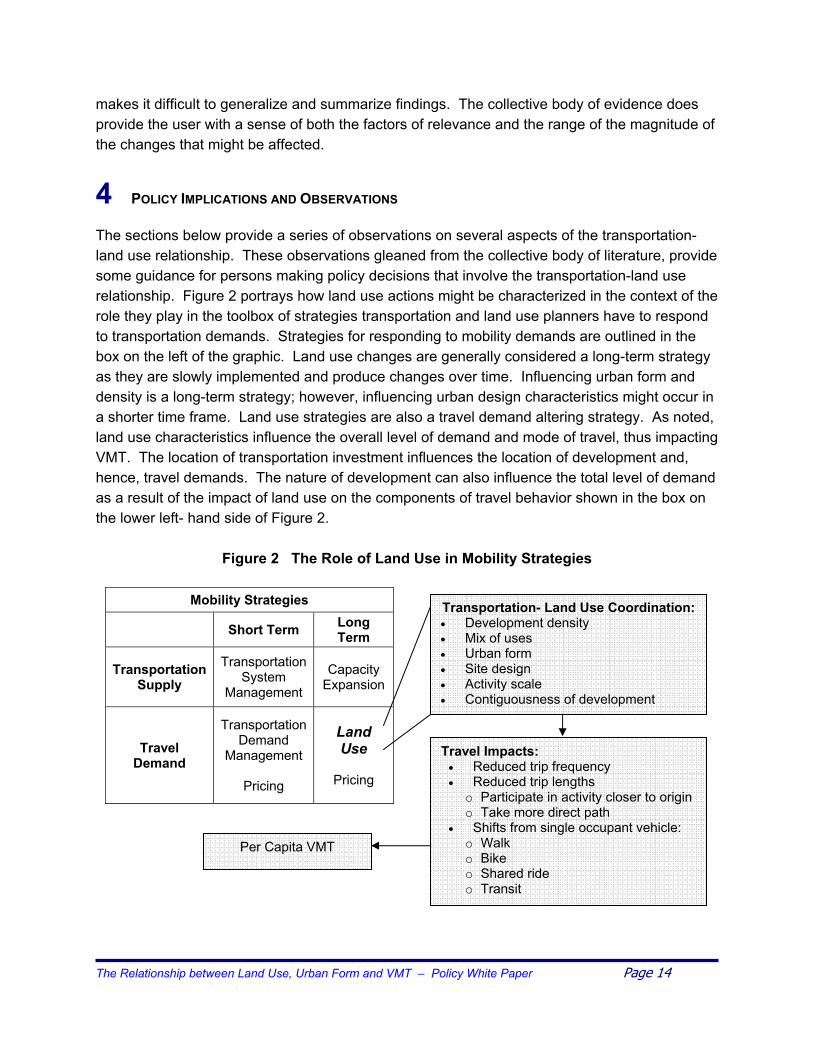
4 POLICY IMPLICATIONS AND OBSERVATIONS The sections below provide a series of observations on several aspects of the transportation-land use relationship. These observations gleaned from the collective body of literature, provide some guidance for persons making policy decisions that involve the transportation-land use relationship. Figure 2 portrays how land use actions might be characterized in the context of the role they play in the toolbox of strategies transportation and land use planners have to respond to transportation demands. Strategies for responding to mobility demands are outlined in the box on the left of the graphic. Land use changes are generally considered a long-term strategy as they are slowly implemented and produce changes over time. Influencing urban form and density is a long-term strategy; however, influencing urban design characteristics might occur in a shorter time frame. Land use strategies are also a travel demand altering strategy. As noted, land use characteristics influence the overall level of demand and mode of travel, thus impacting VMT. The location of transportation investment influences the location of development and, hence, travel demands. The nature of development can also influence the total level of demand as a result of the impact of land use on the components of travel behavior shown in the box on the lower left- hand side of Figure 2.
Figure 2 The Role of Land Use in Mobility Strategies
Per Capita VMT
Mobility Strategies
Short Term Long Term
Transportation Supply
Transportation System
Management
Capacity Expansion
Travel Demand
Transportation Demand
Management
Pricing
Land Use
Pricing
Transportation- Land Use Coordination: • Development density • Mix of uses • Urban form • Site design • Activity scale • Contiguousness of development
Travel Impacts: • Reduced trip frequency • Reduced trip lengths o Participate in activity closer to origin o Take more direct path
• Shifts from single occupant vehicle: o Walk o Bike o Shared ride o Transit
The Relationship between Land Use, Urban Form and VMT – Policy White Paper Page 14

As conceptualized, the respective attributes of land use influence each of the traditional components of travel decision-making. Using land use strategies to influence travel demand is most often envisioned as a strategy to be used in conjunction with other transportation supply and demand strategies. Similarly, the motivations to influence land use should go well beyond a desire to influence transportation demand. The Motivations of Researchers and Research Sponsors The transportation-land use relationship has become a sensitive topic, with environmental, development, agricultural, and infrastructure interests among those that have strong feelings and financial risks associated with policies that might be influenced by the extent of knowledge and findings regarding the transportation-land use relationship. Thus, readers and decision- makers should use caution when reviewing various research reports and publications regarding the transportation-land use relationship. Growth management regulations and transportation funding referendums are among the public decisions that are often influenced by writings on the nature of this relationship. While all researchers have values that influence their research methodology and the interpretation of their findings, in the case of the transportation-land use relationship, research is often sponsored by specific interests and targeted to produce findings that support specific views. Powerful emotional arguments and symbolism are often used to leverage the influence of the theoretical and technical information about the transportation-land use relationship. The term “sprawl,” for example, has developed specific non-descriptive connotations. “Balanced transportation” implies an unbalanced and implicitly unattractive alternative. “Smart growth” suggests the alternative is “dumb growth,” and the term “property rights” can imply privileges beyond what the law actually ensures. While not a unique context, the highly emotional nature of the subject should encourage readers to exercise caution and consider multiple perspectives when considering decisions whose impacts are premised on an assumed transportation-land use relationship. Urban Form and Intercity Travel Relationships The nature of urban travel impacts intercity travel. Specifically, urban form and land use characteristics that support public modes of travel within the urban area are likely to result in conditions that make intercity public modes of travel more viable. When exploring the viability of intercity rail, the presence of urban transit systems as feeder and distributor systems are regularly considered as important factors. The nature of the concentration of activities in urban areas can complement the intercity connections if activities are concentrated in patterns that support a station or stations for intercity travel modes. To the extent that higher densities support better public transportation in urban areas, and better urban public transportation supports better intercity public travel options, then there is an indirect affect that is not necessarily captured in much of the research. This is another relationship that, while not specifically explored in this effort, appears to be under represented in the literature.
The Relationship between Land Use, Urban Form and VMT – Policy White Paper Page 15

Business Economics and the Transportation-Land Use Relationship Transportation-land use discussions often assume that one is trying to minimize the sum of transportation and development costs by looking at the costs of transportation and the costs of land development. Often ignored in this equation are the business and or other public costs associated with operating activities at a given scale. Regardless of the urban form, modal options, transportation network configuration, and density, many individual land uses are now choosing to develop at a larger scale. The “big box” store is an obvious example and grocery stores are also becoming dramatically larger. For any given population density, a larger facility requires a larger market area to provide a client base sufficient to support the activity. A larger market area results in longer average trips to access the facility. One of the tradeoffs that the customer may be making for the benefit of having larger selections, extended hours, and lower product costs, is higher transportation costs due to the need to travel farther to the facility. Similarly, high schools are getting much larger to accommodate the diversity of activities and features to enable a cost-effective facility. Functions such as gymnasiums, pools, media centers, etc., and specialty services such as professionals working with disabled individuals cannot be delivered as economically in smaller facilities. Thus, the business model (the economically viable size) for many land uses has changed over time resulting in longer average trip lengths to access these activities. While land use patterns and regulatory control can influence the size of facilities, the competitive economics of various land use functions is favoring larger facilities for purposes such as shopping and schools and producing longer travel distances that are less likely to be within the range of walk or bike travel. The magnitude of the impact of this phenomenon on VMT is not well understood. Urban areas and planning professionals are beginning to recognize this issue and a variety of responses from rethinking the merits of supersized facilities to efforts to integrate their design within the overall scale of the community are underway. Complex relationships, such as the prospect that superstores minimize the number of trips but produce longer trips, need to be considered as the issue of activity scale is explored. The Future of the Transportation-Land Use Relationship The desirability or optimality of some aspects of urban form and transportation network configuration are dependent on the overall urban size and configuration. The optimal urban form and land use pattern can change as an urban area grows. Analysis might suggest that at some urban area size, a polycentric urban form may be more efficient than a monocentric urban form. However, the transition between these two forms may take many years and during this time the overall urban configuration may not be optimal in terms of minimizing VMT. Given the long time frames for land development and change in transportation networks, planners may be aiming at a moving target in terms of desired land use pattern. As more is learned about land use patterns that maximize accessibility and minimize VMT, more research may be required to explore how these principles might be applied to growing and evolving urban areas. As edge
The Relationship between Land Use, Urban Form and VMT – Policy White Paper Page 16

cities develop and adjacent metropolitan areas grow together, areas may go through stages where the optimal development pattern and transportation network configuration changes. The responsiveness of transportation demand to land use characteristics may also change over time if peoples’ motivations change. The demand for travel is influenced by factors including the time and money costs of travel. If travelers are not sensitive to time and money costs of travel, they will be less inclined to take advantage of urban design characteristics that enable them to minimize their travel. Certain land use characteristics such as pedestrian accessible mixed use areas may enable travelers to adapt to different conditions (such as fuel shortages) far more readily than other patterns; however, this benefit may not be captured under current conditions. Thus, a benefit of land use patterns that enhance multimodal accessibility may be in the contingency value they offer should travel costs, fuel availability, environmental considerations or other conditions be different. If current costs and values change, VMT may be more responsive to land use characteristics.
5 CONCLUSIONS
The Dilemma of Uncertainty
The results described in this chapter are mixed and messy. …. The data are often poorly suited to the purpose, the research designs are faulty or ad hoc and thus difficult to generalize, and the statistical methods applied to the data are typically primitive. This does not mean that the results are incorrect, only that they may lack sufficient robustness to be the basis for policy.
Boarnet and Crane, Travel by Design, p. 58 Even a modest familiarity with the literature on transportation and land use can lead one to suffer the frustrations expressed by the above authors. Two factors contribute to that frustration. First, the nature of the topic is enormously complex and dynamic, and thus difficult to analyze. Such analysis requires extraordinary amounts of data and resources to discern the complex relationships. Second, the risk of error is significant. The time frames, costs, and socio-political consequences of attempting policy interventions to influence transportation or land use are potentially huge. Be it altering transportation investment programs and priorities or attempting to influence land use decisions, the consequences are enormous. Property rights are strongly held and travel freedoms highly valued. Initiatives to meaningfully alter property rights or travel behavior are highly scrutinized. Few topics engender greater public interest and emotion than significant initiatives to influence travel and location decisions. Accordingly, the challenge is attempting to make prudent policy and investment decisions in the context of a highly uncertain, complex and controversial environment. Likewise, advocates for leveraging the transportation-land use relationship to influence policy and investment make a compelling case. The quality of life, safety, energy independence, The Relationship between Land Use, Urban Form and VMT – Policy White Paper Page 17
mobility for certain segments of the population, air quality, and the performance of our transportation systems are impacted by the transportation-land use relationship. The increases in VMT and changes in land use patterns paint a compelling picture of cause and effect. The long time frame for land use and transportation decisions tempt one to start now and not wait for definitive research as it “may be too late.” The prudent decision-maker is left with a vexing challenge of determining whether what is known is sufficiently accurate and robust to support the policy decisions at hand. Two specific questions merit comment. What decisions are appropriate given what we know, and, what decisions might not be prudent given the state of knowledge? There remains a host of impediments to greater knowledge about the relationship between land use and VMT. The magnitude of costs and time frame for experimentation or observational studies is very long with the risks of intervening context changes confounding the interpretation of the results. Greater knowledge and enhanced methods offer promise, yet the inherent complexity of the relationships and challenges in measurement and attribution of causality are likely to remain until human behaviors can be more definitively understood. The search for objective research perspectives may continue to be a problem, and disparate interpretations and conflicting findings, particularly if they are associated with identifiable biases in perspective, will impact the pace at which a consensus on findings can be developed. Which Decisions are Appropriate, Given What We Know? Given what is known about transportation and land use, a number of actions can be identified that, if taken, appear prudent even in light of the uncertainty regarding the relationship between transportation and land use. Decisions are most difficult if there is a negative tradeoff required to realize a potential benefit. But, in some cases, decisions can be characterized as win-win, that is, there are not necessarily any negative consequences or tradeoffs associated with the decisions. A good example of such a decision might be using transportation-sensitive urban design characteristics. At no or little cost, something as simple as a well-designed site plan may produce positive travel behavior reactions. It may facilitate walk and transit access, increase travel safety, and provide attractive aesthetics, all simply by orienting development elements on a site more sensitively without increasing the development cost. Other decisions that can be supported with the current level of knowledge are those that enable land use changes that are known to be more supportive of economy in vehicle travel. As portrayed in Figure 3, land use regulation might be thought of as ranging across a continuum that extends from precluding a given type of land use characteristic, to enabling, then encouraging, and finally prescribing that characteristic. In many instances, land use policies that are felt to be supportive of efficient land use characteristics (lower VMT) can simply be enabled or encouraged and not necessarily prescribed. This strategy of shifting toward transportation sensitive land use characteristics need not override market forces but rather enable accommodation, thus limiting the costs and risks from the consequences not being those The Relationship between Land Use, Urban Form and VMT – Policy White Paper Page 18

that were hoped for. For example, parking space requirements could be reduced in locations where the availability of options results in adequate alternatives.
Figure 3 Continuum of Land Use Regulation Proactiveness
Preclude Enable Encourage Prescribe
Finally, it is often noted that reward is often born out of risk. Thus, there may be some policy and investment decisions in transportation or land use that are premised at least partially on the transportation-land use relationship producing a specific set of impacts that are the basis for the decision. In these situations, the decision-makers are left with the task of assessing the risk and determining a resultant decision. While the discussion in the following section might be of assistance in thinking through these decisions, the decision-making party is ultimately entrusted with having to pass judgment subject to the reliability of the current state of knowledge. Which Decisions Might Not be Prudent, Given the State of Knowledge? A cynic might wonder why it is important to provide an enhanced level of understanding of the transportation-land use relationship when it appears many decisions are governed by emotional and political considerations. Why, for example, might one be willing to more aggressively regulate land use when there is a reluctance to increase fuel fees or assess development impact fees in spite of overwhelming evidence that transportation is under funded? While research data and theory may never be the sole decision criteria, providing objective information to support policy deliberations remains a critical responsibility of planners and researchers. The level of interest in policy actions that leverage the transportation-land use relationship remains particularly high. Land use is something of a “last frontier” in initiatives to address transportation problems. Part of the appeal of leveraging the transportation-land use relationship is that it offers promise. At a time when both human and political nature is to pursue visions that offer hope and appear to provide a rational solution with a tolerable set of consequences, the prospect of leveraging the transportation-land use relationship to craft new policy and investment programs has appeal. For a problem that has been relatively intractable like responding to growing travel demand, transportation-land use coordination seems to offer the prospect of meaningful progress – or at least creates that impression. Not without some trial and error, a growing sense of the magnitude and robustness of the relationship between transportation and land use is evolving and may increasingly influence policy and investment decisions. It is probable that a more refined sense of how each of the elements of land use, including urban form and design, influence travel behavior will develop over time. Ideally, the combined impact of various elements of land use can be understood in the context of how each relevant aspect of travel behavior would be expected to be impacted, what mitigating or qualifying contextual conditions would apply, and how stable the relationships
The Relationship between Land Use, Urban Form and VMT – Policy White Paper Page 19

are. Most important will be having the ability to trace transportation-land use interrelationships with sufficient quantitative precision so that policy makers are in a position to weigh the impacts of various actions against the financial, political, and other quality of life changes. In practical and tactical terms, this may mean that certain decision types may be preferred, and, as the level of certainty in our knowledge of the transportation-land use relationship grows, we can feel greater comfort making higher risk decisions. Figure 4 characterizes some parameters of various investment or policy decisions. If a given decision has more traits that fall further to the right in the diagram, then one would want a higher degree of confidence that the assumed relationship between transportation and land use was as presumed in the decision analysis or a very high potential benefit to justify the risks.
Figure 4 Decision Risk Continuum
Lower Risk Higher Risk
Low Cost High Cost Reversible Irreversible Near Term Impact Long Term Impact Supported by Contextually Similar Experience Original/Untried Application
If there is an overwhelming message in the body of literature that addresses the relationship between transportation and land use, it is that the relationship is important, complex and currently only moderately well understood. More recent studies with richer databases and more methodological rigor as well as the growing body of cumulative evidence provide greater comfort in reaching conclusions such as those noted in the beginning of Sections 3. Nonetheless, it is important to recognize that many human behaviors, such as purchasing decisions, leadership selection (voting), and investment decision-making, have been extensively researched with massive investments of time and methodological rigor but have produced only modestly successful ways of forecasting human behavior. Few have been successfully able to predict what toys will sell for Christmas, who will win next year’s election, or which stock will increase in value next year. Yet, planners set high expectations for being able to understand the human travel behavior and location decision-making embodied in the transportation-land use relationship with a precision that will support making multi-decade, high-cost, high-consequence decisions. While the motivations and behaviors that underlie travel and location decision-making may be more predictable than those that underlie the other referenced choice processes, the planning and transportation communities will be well served to continue to recognize that the state of knowledge is still evolving. Perhaps even more relevant, the fundamental personal values and the socio-political relationships that underlie personal activity patterns, travel demand and mode choice decisions, and location decisions may be changing. Witness the growing interest in relating obesity and physical health to physical environments and travel behavior (49). Thus, both refining our knowledge and monitoring change in the transportation-land use relationship is required; while we strive to make today’s decisions based on the best available information.
The Relationship between Land Use, Urban Form and VMT – Policy White Paper Page 20

The Relationship between Land Use, Urban Form and VMT – Policy White Paper Page 21
References 1) U.S. Department of Transportation, Federal Highway Administration and Federal Transit
Administration, 2002 Status of the Nation's Highways, Bridges, and Transit: Conditions & Performance Report to Congress, http://www.fhwa.dot.gov/policy/2002cpr/cp02_pdf.htm, Executive Summary, page ii.
2) Schrank D., and Lomax T., The 2003 Annual Urban Mobility Report, College Station,
Texas Transportation Institute & The Texas A&M University System, September 2003. 3) American Society of Civil Engineers, “2003 Progress Report, Report Card for America’s
Infrastructure,” March 2003. http://www.asce.org/reportcard/index.cfm?reaction=full&page=6
4) Kenworthy and Newman, “Gasoline Consumption and Cities,” Journal of the American
Planning Association, 1989. 5) Real Estate Research Corporation, Cost of Sprawl. 1974. 6) Boarnet and Crane, Travel by Design, The Influence of Urban Form on Travel, Oxford
University Press, 2001. 7) Land Use and Site Design, Traveler Response to Transportation Sys em Changes,
Chapter 15, TCRP Report 95, Transportation Research Board, Washington, D.C., 2003 t
8) Skinner, Robert, Jr. “The Transportation-Land Use Interaction, Introduction”, TR News
187, November-December 1996, p. 6. 9) Hu, Patricia, and Tim Reuscher, “Summary of Travel Trends 2001 National Household
Travel Survey,” U.S., Department of Transportation, Federal Highway Administration, July 2003, p. 1.
10) U.S. Department of Transportation, Federal Highway Administration. Highway Statistics
2001. Table VM-2 (Functional System Travel: Annual Vehicle-Miles) and Table HM-44 (National Highway System Travel: Annual Vehicle-Miles by Functional System) http://www.fhwa.dot.gov/policy/ohpi/hss/hsspubs.htm
11) Pisarski, Alan, Commuting in America II, Eno Transportation Foundation, 1996, p.19. 12) Pisarski, Alan, Commuting in America II, Eno Transportation Foundation, 1996, p. 25. 13) Polzin, Steve, Xuehao Chu and Lavenia Toole-Holt, “The Case for Moderate Growth in
Vehicle Miles of Travel: A Critical Juncture in U.S. Travel Behavior Trends,” White Paper, Center for Urban Transportation Research, September 2003.
14) Davis, J., “The Commuting of Exurban Residents.” Urban Geography 14, Vol.1, p. 7-29.
1993. 15) Dunphy, R. and K. Fisher, K., “Transportation, Congestion, and Density: New Insights.”
Paper presented at the 73rd annual meeting of the TRB, Washington DC. January, 1994.

The Relationship between Land Use, Urban Form and VMT – Policy White Paper Page 22
16) Calthorpe Associates, “Take Charge Twin Cities: The Smart Growth Twin Cities
Development Scenarios Indicator Modeling Summary” May 2002. 17) Institute of Transportation Engineers, Trip Generation Handbook, Sixth Edition, March
2001. 18) Ewing, R. and R. Cervero, “Travel and the Built Environment, A Synthesis.”
Transportation Research Record 1780; p. 87-114. 2001. 19) “Parking Management and Supply”, Chapter 18, TCRP Report 95, Transportation
Research Board, Washington, D.C. 2003. 20) Lynx, 2003-2007 Transit Development Plan – Appendix F. Available online at
http://www.golynx.com/articles/tdp/AppendixF.pdf. 21) “Statewide Urban Design and Specifications,” Iowa Statewide Urban Design Standards
Manual, 1998. Available online at http://www.iowasudas.org/design.cfm#fm. 22) The City of Las Vegas, Planning and Development, “Urban Design Guidelines and
Standards,” March 1997. Available online at http://www.ci.las-vegas.nv.us/Files/DesignStds.pdf
23) Robert Cowan, Urban Design Guidance: Urban Design Frameworks, Development
Briefs and Master Plans. American Society of Civil Engineers; Thomas Telford, Ltd., 2002.
24) A Nelessen Associates, Inc., “Hillsborough County MPO Visual Preference Survey, Final
Report,” Princeton, New Jersey, July 30, 2001. 25) Toole-Holt, Lavenia, “Do Spatial Structures and Attributes Impact Average Commuting
Time?” Term Paper, University of South Florida, December 2003. 26) Cevero, Robert. “Mixed Land Uses and Commuting: Evidence from the American
Housing Survey.” Transportation Research A 30(5), p. 361-377, 1996. 27) Ewing, Reid; Haliyur, Padma and William Page, “Getting Around the Traditional City, a
Suburban Planned Unit Development, and Everything Between.” Transportation Research Record 1466, p. 53-62, 1994.
28) Frank, Lawrence and Gary Pivo, “Impacts of Mixed Use and Density on Utilization of
Three Modes of Travel: Single-Occupant Vehicle, Transit and Walking.” Transportation Research Record 1466, p. 44-52. 1994.
29) Handy, Susan, “Methodologies for Exploring the Link between Urban Form and Travel
Behavior.” Transportation Research D 1(2). p. 151-165, 1996. 30) Crane, Randall. “Travel by Design?” Produced by Access Journal. June 2002.

The Relationship between Land Use, Urban Form and VMT – Policy White Paper Page 23
31) Ewing, R. and R. Cervero, “Travel and the Built Environment, A Synthesis.” Transportation Research Record 1780; p. 87-114, 2001.
32) McCormack, E; Rutherford, GS and MG Wilkinson. “Travel Impacts of Mixed Land Use
Neighborhoods in Seattle, Washington” Transportation Research Record 1780. p. 25-32, 2001.
33) Ewing, R., E. Dumbaugh, and M. Brown. “Internalizing Travel by Mixing Land Uses:
Study of Master-Planned Communities in South Florida.” Transportation Research Record 1780: paper number 01-3524, 2001.
34) The New Transit Town: Best Practices in Transit-Oriented Development, Island Press,
December 2003. 35) The Center for Transit Oriented Development,
http://www.reconnectingamerica.org/html/TOD/index.htm 36) The Center for Transportation Excellence, http://www.cfte.org/ 37) Multimodal Transportation Districts and Areawide Quality of Service Handbook, Systems
Planning Office, Florida Department of Transportation, November 2003. http://www.dot.state.fl.us/planning/systems/sm/los/pdfs/MMAreawideQOS1211.pdf
38) Creating Great Neighborhoods: Density in Your Community, Local Government
Commission in cooperation with U.S. EPA., September 2003. http://www.epa.gov/livability/pdf/density.pdf
39) Kenworthy and Newman, “Gasoline Consumption and Cities,” Journal of the American
Planning Association, 1974. 40) Gordon and Richardson, A Comparison of International Cities, Journal of the American
Planning Association, 1977. 41) Miller, E. and A. Ibrahim. “Urban Form and Vehicular Travel: Some Empirical Findings.”
TRR Paper no. 98-1067, 1998. 42) Holtzclaw, J. “Using Residential Patterns and Transit to Decrease Auto Dependence and
Costs.” San Francisco, CA: Natural Resources Defense Council, 1994. 43) Pederson-Stahl, Susan, “Smart Growth and the Jobs-Housing Balance” Term paper,
University of south Florida, December 2003. 44) Cervero, Robert, “Jobs-Housing Balance and Regional Mobility, Journal of the American
Planning Association, No. 55:136-150, 1997. 45) Wachs, et. al., “The Changing Commute: A Case Study of the Jobs-Housing
Relationship Over Time,” Urban Studies, Vol. 30, pp.1711-1729, 1993. 46) Giuliano et. al., “Is the Journey to Work Explained by Urban Spatial Structure,” Urban
Studies, Vol. 30, pp.1485-1500, 1993.
The Relationship between Land Use, Urban Form and VMT – Policy White Paper Page 24
47) Frank et. al., “The Relationship Between Land Use and Travel Behavior in the Puget
Sound Region,” Washington Department of Transportation, 1994. 48) Holtzclaw, J. “Explaining Urban Density and Transit Impacts on Auto Use” Paper
presented to the State of California Energy Recourses Conservation and Development Commission by Natural Resources Defense Council and the Sierra Club. 1990.
49) American Journal of Public Health, Vol. 93, No.9. Numerous articles. September 2003.