Embed Size (px)
Citation preview

3.11H
azardous Materials

GOLD LINE DRAFT ENVIRONMENTAL IMPACT STATEMENT
3.11-1 JULY 2008
3.11 Hazardous Materials
3.11.1 Introduction to Analysis
3.11.1.1 Summary of Results Hazardous materials sites may be encountered during the construction of the stations and the alignment associated with the Preferred Alternative. There are an estimated 4 sites within the trackway and up to 14 sites are found at the stations sites, depending on the design option selected. In general, there is a greater potential to encounter hazardous material sites in the Denver and Adams Sections as compared to the Arvada and Wheat Ridge Sections. The greatest potential for conflicts with hazardous materials would be during construction of the section of alignment from DUS to Pecos Street that is constructed for the Northwest Rail project under the No Action Alternative, and shared with the Gold Line project (Preferred Alternative).
When contaminated soils or groundwater are encountered, they would be characterized and properly disposed under the guidance of RTD's Materials Management Plan, which would be prepared prior to construction.
3.11.1.2 Purpose The presence or release of hazardous materials on construction sites can expose workers, residents, and other ecosystems to contaminants that may compromise their health. As a result, evaluation of the potential for rail projects to impact or be impacted by hazardous material sites is required by regulation.1 Encountering hazardous waste during construction is costly and can affect the cost-effectiveness of the project.
3.11.2 Affected Environment A Modified Phase I Environmental Site Assessment (MESA) was prepared for the Gold Line study area and evaluated known spills of hazardous substances or petroleum products along the proposed alignment (Walsh, 2006). Walsh completed an additional review of hazardous material sites for the East Direct Design Option in April 2008 (Robinson, 2008). The MESA was compared to a similar document produced for the Northwest Rail project for the section of the alignment from DUS to Utah Junction (Goodbee, 2005).
More than 900 individual listings were identified along the proposed 11.2 mile alignment2. Of these, 128 listings were ranked as having a high potential for environmental contamination and 139 listings were ranked as having a moderate level of potential concern. The facilities are counted as listings at this stage because there was no reconciliation of sites with multiple listings, and the same facility might have been counted several times. The remaining listings were ranked as low or negligible.
The Walsh MESA included a summary of the number of ranked sites by municipal area. Using the available information, numbers of sites within 1,000 feet of the proposed alignment are shown by section in Table 3.11-1.
1 Comprehensive Environmental Response, Compensation and Liability Act 2 This includes 3.5 miles of shared alignment for the Northwest Rail and Gold Line projects and the remaining 7.7 miles west of Pecos Street used only by the Gold Line project.

GOLD LINE DRAFT ENVIRONMENTAL IMPACT STATEMENT
3.11-2 JULY 2008
TABLE 3.11-1 Site Ranking Summary (Sites within 1,000 feet of the Proposed Alignment)1
Section High Sites
Moderate Sites
Low Sites
Total Sites
Denver 31 51 378 460 Adams 36 46 83 165 Arvada 43 36 130 209 Wheat Ridge 18 6 46 70 Total 128 139 637 904 Source: Walsh, 2006 1 Some listings did not have a city reported or were located in an “unincorporated” area. There was not
sufficient information to determine if the listing was in unincorporated Jefferson or Adams County.
3.11.3 Impact Evaluation
3.11.3.1 Methodology The sites that were ranked as high and moderate were mapped onto the proposed footprint of the Preferred Alternative, as well as the section of track shared with Northwest Rail. The footprint included areas of construction along the proposed alignment, as well as properties needed for proposed stations. This information was used to identify potential areas of concern for either construction or land acquisition. The use of the anticipated construction footprint eliminated many of the original sites identified in the Walsh MESA because they would not have an impact on construction activities and would not be part of a parcel purchased for ROW.
3.11.3.2 Results The potential for encountering hazardous materials in the Gold Line study area is closely correlated with land use. Commercial and industrial land uses generally present the greatest risk for encountering hazardous materials. The presence and character of hazardous materials are expected to be typical of most urban and urbanizing areas, including groundwater contamination from Leaking Underground Storage Tanks (LUST), asbestos and lead paint from older buildings and bridges, contaminated soils along the railroad ROW, and residual pesticides from agricultural activities.
No Action Alternative The No Action Alternative assumes that existing and committed improvements, as defined in Chapter 2, Alternatives Considered, would be implemented by others as planned.
Direct Impacts Roadway Projects Implementation of the Sheridan Boulevard project would be through a heavily commercial section. Although there are no design details available for this project, it appears that the construction may affect hazardous waste sources or underground storage tanks (USTs) because of the commercial nature of both sides of the roadway. Potential contaminants include petroleum-based fuels, other hydrocarbon compounds, and solvents.
Implementation of the I-70 and Kipling Interchange project would be within an existing commercial area. It is probable that construction would not directly affect hazardous materials because the interchange is somewhat isolated from the commercial properties and is therefore not likely to sit on any abandoned USTs.

GOLD LINE DRAFT ENVIRONMENTAL IMPACT STATEMENT
3.11-3 JULY 2008
Implementation of the Wadsworth Boulevard project is also located within an existing commercial area. Although there are no design details available for this project, it appears that the construction may affect hazardous waste sources or USTs because of the commercial nature of both sides of the roadway. Potential contaminants include petroleum-based fuels, other hydrocarbon compounds, and solvents.
Northwest Rail Project The risk of encountering hazardous materials from DUS to Pecos Street is about the same for the Railroad Alignment and the East Direct Design Option. Using the Railroad Alignment, construction of the Northwest Rail project in this section would involve the risk of encountering approximately 500 hazardous waste sites as the alignment passes through the freight rail corridor. Figure 3.11-1 presents the sites within the construction footprint of the project that are ranked moderate or high risk. Construction-related activities that may encounter hazardous materials include the removal or replacement of contaminated track ballast or railroad ties, excavation and drilling during construction of bridge abutments and piers, and excavation during construction of stations. The removal or replacement of existing, contaminated track ballast or railroad ties would be an issue throughout the freight railroad ROW.
Potential hazardous waste sites associated with the East Direct Design Option are generally associated with private commercial or industrial businesses (Table 3.11-2). In addition, the East Direct Design Option would require the demolition of more buildings, as compared to the Railroad Alignment; therefore, there is a greater potential to encounter asbestos or lead based paint.
The risks of hazardous materials north of Pecos Street to near Lowell Boulevard, where the Northwest Rail alignment exits the Gold Line study area are unknown.
Contaminated soils or groundwater would be characterized and properly disposed of in conformance with RTD’s Materials Management Plan, which would be prepared prior to construction of the Northwest Rail project.
Indirect Impacts Construction of the above-referenced projects would not likely involve indirect impacts to hazardous materials. Future design refinements would provide additional information on the potential indirect impacts to hazardous materials.
Temporary Construction Impacts All direct impacts would occur during the construction phase and are not repeated here.
Cumulative Impacts The construction of the No Action Alternative would encounter hazardous materials. These materials would be removed from the site and properly disposed. The construction of all other infrastructure required to accommodate the 2030 population, including all the remaining FasTracks projects, would result in the exposure and remediation of unknown quantities of hazardous waste. Therefore, these materials would no longer represent a potential threat to human health and the environment. The operational effects of future projects on hazardous waste generation are well controlled by state and federal regulation, thereby avoiding the impacts of the past.

3.11-4
GOLD LINE DRAFT ENVIRONMENTAL IMPACT STATEMENT
JULY 2008
All Sites Ranked as Moderate or High within the Proposed Project Construction Footprint FIGURE 3.11-1
GOLD LINE DRAFT ENVIRONMENTAL IMPACT STATEMENT
3.11-5 JULY 2008
TABLE 3.11-2 Private Commercial and Industrial Sites Ranked as Moderate or High: East Direct Design Option
ID # Name of Site Address Ranking1 Comments East Direct Design Option (Northwest Rail)
2 Power Rental Equipment 725 West 39th Avenue High UST within footprint and
current site activity
10 Brannan Sand and Gravel 730 West 42nd Avenue/ 4100 Fox Street
High UST within footprint, LUST within footprint and source activity
11 Westric Battery Company West of Galago Street/ South of 43rd Avenue
High Acid plant noted on historical documents in the 1920s
12 AAA Waterproofing 750 West 48th Avenue High UST within footprint and
current source activity
13 Rocla Concrete Tie Inc. 701 West 48th Avenue Moderate Source in the footprint
14 Qwest Communications 5151 Fox Street High UST within footprint and current source activity
15 Owens-Corning Fiberglass Roofing Products 5201 Fox Street High
UST within footprint, current source activity, and possible spill of hazardous materials
16 B&B Blending 5285 Fox Street Moderate Former source activity
17 Bioenergy of Colorado 801 West 56th Avenue High Landfill and source activity
18 Intersection Parking Lot 53rd Place/Fox Street Moderate
Spill of hazardous materials on property adjacent to footprint
Source: Gold Line Team, 2007 1 Rankings are based on professional judgment and the distance from the centerline of the alignment or
station boundary, for each information source (for example, Federal National Priority List or UST)
Preferred Alternative Direct Impacts As with the No Action Alternative, the majority of direct impacts to hazardous materials associated with the Preferred Alternative would occur during construction.
Denver Section The only property acquisitions in this section are related to the construction of the Denver Section station options and the electric substation. Table 3.11-3 and Figure 3.11-1 show the sites that are potentially within the station footprint and would affect construction. The 38th Avenue, 39th Avenue East, and the 41st Avenue East stations are estimated to affect seven, five and three moderate to high risk hazardous waste sites, respectively.

GOLD LINE DRAFT ENVIRONMENTAL IMPACT STATEMENT
3.11-6 JULY 2008
TABLE 3.11-3 Sites Ranked as Moderate or High within the Proposed Station Construction Footprints in the Denver Section
ID # Name of Site Address Ranking1 Comments 38th Avenue Station
1 The Texas Company Oil Distribution Station
North of 38th Avenue between Galapago Street and the railroad tracks
High
Lubricating oil in tanks observed on historical documentation of property use.
2 Power Rental Equipment 725 West 39th Avenue High UST within footprint and
current source activity.
4 Vasquez Boulevard and I-70 Vasquez Boulevard and I-70 High
Contamination of surficial soils from historic metal smelters in area.
5 Fox Street Service 3901 Fox Street High
UST operated at facility; LUST reported; operations could include use of hazardous substances and petroleum products.
6 Stained soil
West of tracks between 39th Avenue and 43rd Avenue
Moderate Discolored soil observed during aerial photograph review.
7 Zens Tire Inc. 3901 Fox Street Moderate LUST reported.
8 RTD 3997 Fox Street Moderate Operations could include use of hazardous materials or petroleum products.
39th Avenue East Station
1 The Texas Company Oil Distribution Station
North of 38th Avenue between Galapago Street and the railroad tracks
High
Lubricating oil in tanks observed on historical documentation of property use.
2 Power Rental Equipment 725 West 39th Avenue High UST within footprint and
current source activity.
3 Wagner Rents Downtown Branch
805 West 39th Avenue High UST operated at facility.
4 Vasquez Boulevard and I-70 Vasquez Boulevard and I-70 High
Contamination of surficial soils from historic metal smelters in area.
8 RTD 3997 Fox Street Moderate Operations could include use of hazardous materials or petroleum products.
41st Avenue East Station 9 L Northhaft & Son Inc. 4101 Fox Street High UST within footprint.
4 Vasquez Boulevard and I-70 Vasquez Boulevard and I-70 High
Contamination of surficial soils from historic metal smelters in area.
8 RTD 3997 Fox Street Moderate Operations could include use of hazardous materials or petroleum products.
Source: Gold Line Team, 2007 1 Rankings are based on professional judgment and the distance from the centerline of the alignment or
station boundary, for each information source (for example, Federal National Priority List or UST)

GOLD LINE DRAFT ENVIRONMENTAL IMPACT STATEMENT
3.11-7 JULY 2008
Adams Section Property acquisitions in this section would be related to the construction of the stations at Pecos Street and Federal Boulevard. The proposed footprint for the station was compared with the identified sites of concern at both station locations (Table 3.11-4 and Figure 3.11-1). One site would be encountered with the Pecos East Station option as compared with five sites at the Pecos West Station option. Two sites would be encountered with the Federal Station option.
TABLE 3.11-4 Sites Ranked as Moderate or High within the Proposed Station Construction Footprint in the Adams Section
ID # Name of Site Address Ranking1 Comments Pecos East Station
19 Adams County Landfill
East of Pecos Street and South of 62nd Avenue High Landfill within the footprint of the
Pecos East Station, Phases 1 and 2. Pecos West Station
20 Adams County Dump South of 60th Avenue at Wyandot High Landfill within the footprint of the
Pecos West Station, Phase 2.
21 City and County Of Denver
60th Avenue and Shoshone Street High Landfill within the footprint of the
Pecos West Station, Phase 2.
22 No Name Reported 2080-2200 West 60th Avenue High Landfill within the footprint of the
Pecos West Station, Phases 1 and 2.
23 Western Paving 5959 Pecos Street High Landfill within the footprint of the Pecos West Station, Phases 1 and 2.
24 No Name Reported West of Pecos at 60th Avenue High Landfill within the footprint of the
Pecos West Station, Phase 1. Federal Station
25 No Name Reported 2700 West 60th Avenue High Landfill within the footprint of the Federal Station, Phase 2.
26 No Name Reported 60th Avenue and Federal Boulevard (West Side) High Landfill within the footprint of the
Federal Station, Phase 2.
Source: Gold Line Team, 2007 1 Rankings are based on professional judgment and the distance from the centerline of the alignment or station
boundary, for each information source (for example, Federal National Priority List or UST)
In addition to these impacts, landfills in the vicinity of 60th Avenue and Pecos Street are shown as extending to the trackway footprint. Two non-landfill properties are mapped within or immediately adjacent to the trackway footprint in this section (Table 3.11-5).
TABLE 3.11-5 Sites Ranked as Moderate or High within the Proposed Trackway Footprint in the Adams Section
ID # Name of Site Address Ranking 1 Comments
27 Lloyd Cunningham 5901 North Federal Boulevard High Registered UST.
28 Cunningham Property 5900 North Federal Boulevard Moderate
Operations could include use of hazardous materials or petroleum products.
Source: Gold Line Team, 2007 1 Rankings are based on professional judgment and the distance from the centerline of the alignment or station
boundary, for each information source (for example, Federal National Priority List or UST)

GOLD LINE DRAFT ENVIRONMENTAL IMPACT STATEMENT
3.11-8 JULY 2008
Arvada Section No sites are located within the station footprints in the Arvada Section. Two sites are mapped within the trackway footprint or are listed as businesses that would have to be relocated (Table 3.11-6).
TABLE 3.11-6 Sites Ranked as Moderate or High within the Proposed Trackway Footprint in the Arvada Section
ID # Name of Site Address Ranking 1 Comments
29 Lamar Automotive 5690 Lamar Street High Tank leak and operations could include use of hazardous materials or petroleum products. Mapped within the track footprint.
30 Wheat Ridge Regional Center 10285 Ridge Road High
Tank leak and operations could include use of hazardous materials or petroleum products. Property identified for relocation of operations.
Source: Gold Line Team, 2007 1 Rankings are based on professional judgment and the distance from the centerline of the alignment or station
boundary, for each information source (for example, Federal National Priority List or UST)
In addition to these sites, there is an area of excavation proposed for construction of a retaining wall to the west of Wadsworth Boulevard. A LUST immediately adjacent to this area (Lucky Mart at 7201 Grandview Avenue) has not received a required No Further Action letter from the State of Colorado. Prior to construction activities, information regarding the extent of contamination should be reviewed and considered during development of a Materials Management Plan. It is possible that remediation will be completed before construction begins.
Wheat Ridge Section No sites of concern were identified within the project footprint in the Wheat Ridge Section.
Indirect Impacts The Preferred Alternative is not anticipated to have indirect impacts on hazardous materials. Future design refinements would provide additional information on the potential indirect impacts to hazardous materials.
Temporary Construction Impacts All direct impacts would occur during the construction phase and are not repeated here.
Cumulative Impacts The cumulative impacts discussed above for the No Action Alternative are analogous to those anticipated for the Preferred Alternative.
3.11.4 Mitigation Measures Mitigation techniques to reduce identified impacts to hazardous materials are described in Table 3.11-7.

GOLD LINE DRAFT ENVIRONMENTAL IMPACT STATEMENT
3.11-9 JULY 2008
TABLE 3.11-7 Mitigation Measures for Hazardous Materials under the Preferred Alternative
Impact Impact Type Mitigation Measure for the Preferred Alternative
Existing hazardous material sites within or adjacent to areas of proposed excavation and acquisition of property
Construction • Evaluate ballast and railroad ties to be removed and disposed of with the proper waste classification. Disposal must be appropriate for the resulting classification.
• Complete site–specific Phase II Environmental Site Assessments (ESA) with subsurface investigation (soil and groundwater) for sites that may have been contaminated or affect final design, as documented by the Phase I ESA, where appropriate.
• Prepare a Health and Safety Plan and a Materials Handling Plan to address contaminated soil and groundwater.
• Determine engineering controls to minimize quantity of contaminated materials.
• Determine cost recovery of hazardous material sites where removal actions and long-term maintenance is required.
• Conduct an individual site-specific Phase I ESA of properties before acquisition.
• Prepare an asbestos survey for any building acquisition or demolition.
Water quality protection
Construction • Implement construction BMPs in accordance with a Stormwater Pollution Prevention Plan. BMPs may include secondary containment areas for refueling construction equipment, berms or ponds to control runoff, and a monitoring program to test stormwater for contaminants prior to discharge from the construction site.
Protection of construction workers
Construction • Compliance with Occupational Safety and Health Administration requirements for construction workers who may be exposed to hazardous materials, including preparation of Health and Safety and Emergency Response Plans, air monitoring (if necessary), and provision of personal protective equipment.
Source: Gold Line Team, 2007
3.12S
afety and Security

GOLD LINE DRAFT ENVIRONMENTAL IMPACT STATEMENT
3.12-1 JULY 2008
3.12 Safety and Security
3.12.1 Introduction to Analysis
3.12.1.1 Summary of Results Since the implementation of RTD’s LRT system, crime on board vehicles and at stations has been statistically insignificant. The majority of offenses are non-violent crimes, such as trespassing and disorderly conduct on vehicles and theft and vandalism of automobiles at stations.
Based on historic experience, the Preferred Alternative would have no affect on crime in the study area. Crime at the transit stations or on the EMU vehicles is expected to reflect the crime activity of the surrounding communities, which would be similar to the No Action Alternative. The proposed stations of the Preferred Alternative would not increase the local rate of crime but would be representative of the surrounding neighborhood crime rates. Therefore, neighborhoods with high crime rates would continue to experience higher-than-average crime rates with or without the proposed stations. As a result, crime rates higher than average are predicted at any of the 38th Avenue Station options in Denver and the Ward Road Station in Wheat Ridge. These stations would be monitored upon implementation and more aggressive security measures may be needed at these locations.
3.12.1.2 Purpose Increased criminal activity and impeded emergency vehicle access are concerns of communities within the Gold Line study area. Because of these concerns, existing and future safety and security issues in the Gold Line study area have been analyzed as they relate to passengers and the surrounding community. In particular, the likelihood of change to crime rates and the effects of the project on emergency response times in the Gold Line study area have been evaluated.
3.12.2 Affected Environment The RTD Safety and Security Manual defines measures the agency takes to ensure the safety and security of its rail transit patrons and those indirectly impacted by their operations. The measures include a Safety and Security department that provides vehicle on-board security staff during hours of rail operation and station area security staff. Emergency telephones are located in station areas and closed circuit television coverage is provided at designated stations, parking structures and lots, and in vehicles. The RTD security force works with the local police to control crime on-board vehicles, along the corridor, at station areas, and in parking facilities.
For implementation of the Gold Line project, RTD would convene a Fire and Life Safety Committee comprised of representatives from local law enforcement and emergency services. This committee would assist in the development of an emergency plan for the Gold Line study area and coordinate responses to various emergency situations. Design criteria contain guidelines for station areas to reduce crime at stations and parking facilities. These guidelines are to be followed unless a waiver is obtained from the RTD Safety and Security Committee. The Gold Line project would include security cameras and emergency telephones that would be connected with the RTD security command center and monitored by security personnel.

GOLD LINE DRAFT ENVIRONMENTAL IMPACT STATEMENT
3.12-2 JULY 2008
3.12.2.1 Station Area and On-board Crime To determine the existing station area and on-board crime rates, crime statistics were gathered for each of the communities in the Gold Line study area for 2005 as listed in Table 3.12-1.
TABLE 3.12-1 Existing Annual Crime Statistics by Section – 2005
Section Agency Homicide Rape Robbery Burglary Auto Theft Denver City and County of Denver
Police Department 61 322 1,424 7,318 7,769
Adams Adams County Sheriff’s Department
0 0 85 1,438 0
Arvada City of Arvada Police Department
2 23 52 524 581
Wheat Ridge City of Wheat Ridge Police Department
1 22 31 350 362
Source: US Department of Justice, 2005
The figures shown in these tables are categorized according to standards used by the Federal Bureau of Investigation’s Uniform Crime Reporting Program, a program that is used to standardize and track the reporting of crime. In general, areas of more intense urban uses experience higher crime rates. Table 3.12-2 shows crime rates relative to population.
TABLE 3.12-2 Summary of Crime Rates Relative to Population
Section Agency Total Serious Crimes1 2000 Population Crimes Per 1,000 People Denver City and County of
Denver Police Department
16,894 568,913 30
Adams Adams County Sheriff’s Department
1,523 394,257 4
Arvada City of Arvada Police Department
1,182 103,004 11
Wheat Ridge City of Wheat Ridge Police Department
766 31,869 24
Source: Colorado Department of Local Affairs, 2005 1Serious crimes consist of murder, rape, robbery, burglary, and auto theft.
Evaluating the change in crime is important because the crime occurring in and around transit stations is similar to the crime of the surrounding area, and more intense security measures may need to be implemented if necessary. Armed and uniformed officers patrol transit vehicles, pnRs, and stations. This service increases proportionately with increased transit service.
Crime records for existing pnR locations in the Gold Line study area and current transit stations system-wide were examined to assess the safety and security of patrons under current conditions. The existing Olde Town Station in Arvada and the Ward Road Station in Wheat Ridge are the only pnRs near the proposed alignment. The facilities have a total of 711 parking spaces. In general, theft and vandalism are negligible and difficult to isolate to these locations. System-wide, there was only one vandalism incident and 51 theft incidents in 2005, according to RTD statistics (RTD, 2007).
According to RTD statistics, crimes for bus operations in 2005 were negligible. Crime potential for the proposed new stations is anticipated to be similar. Crime on-board RTD’s existing light rail vehicles for 2004 and 2005 is displayed in Table 3.12-3. Disorderly conduct
GOLD LINE DRAFT ENVIRONMENTAL IMPACT STATEMENT
3.12-3 JULY 2008
was the most common offense on vehicles. Threats were the second most recorded offense in these 2 years.
TABLE 3.12-3 Crime On-Board RTD Light Rail Vehicles
Incidents On-board Light Rail Vehicles 2004 2005 Alcohol offense 2 0 Arson 0 1 Assault 2 5 Disorderly conduct 11 5 Drug offense 3 0 Forgery/Counterfeit 0 0 Fraud 0 0 Sex offense 0 1 Theft 0 2 Transit-specific crime 2 1 Trespassing 1 0 Threats 7 5 Weapons offense 2 0 Vandalism 0 1 Total Crime Incidents 30 21 Source: RTD, 2006b
3.12.2.2 Public Services – Police, Fire, and Emergency Police, fire, and emergency services information was provided from various agencies and companies throughout the Gold Line study area. A summary of the existing public safety services by location is presented in Table 3.12-4.
TABLE 3.12-4 Police, Fire, and Emergency Service Locations by Section
Section Police Location Fire Location Emergency Location Denver 1311 West 46th Avenue
1566 North Washington Street 1331 Cherokee Street
745 West Colfax Avenue 2575 North Federal Boulevard 2500 North Washington Street 1890 Lawrence Street 1300 Blake Street 2195 West 38th Avenue 1616 Park Avenue West
Denver Health Medical Center Saint Joseph’s Hospital Saint Luke’s Medical Center
Adams 332 North 19th Avenue 5291 East 60th Avenue
No fire stations were identified in this section
No hospitals were identified in this section
Arvada 8101 Ralston Road 7900 West 57th Avenue 12205 West 52nd Avenue 7300 Kipling Street 6845 West 68th Avenue 8100 Vance Drive 6503 Simms Street 6651 Indiana Street
No hospitals were identified in this section
Wheat Ridge 7500 West 29th Avenue 7300 Kipling Street (Fire Stations in Arvada also respond in Wheat Ridge, depending on location)
Exempla Healthcare Family Institute of Colorado
Source: Gold Line Team, 2007

GOLD LINE DRAFT ENVIRONMENTAL IMPACT STATEMENT
3.12-4 JULY 2008
3.12.3 Impact Evaluation Impacts to public safety and security are discussed below.
3.12.3.1 Methodology Security and safety concerns can be grouped into station area and on-board safety and police, fire, and emergency response.
Station Area and On-Board Safety Studies in areas before and after the introduction of a transit system suggest that stations are as safe as the surrounding commercial activity centers or places that people congregate. The observed frequency of crime at stations tends to mirror the crime of the surrounding area. The majority of these crimes are non-violent acts, such as vandalism and theft. Statistics for RTD’s existing LRT transit system identify similar patterns of crime on-board vehicles, with crime on-board reflecting crime rates in the surrounding area (RTD, 2007).
For purposes of this analysis, the station area and on-board safety category was evaluated by comparing the weighted average of crimes based on the total number of proposed parking spaces at each station. This was accomplished by calculating a crime index for each of the stations based on the number of parking spaces and crime rates of the surrounding areas. A station with a crime index above 1 would be considered higher than the Gold Line study area average, and a crime index less than 1 would indicate a station below the Gold Line study area average.
A composite crime index was then developed by adding the individual crime indices for each station. Because similar types of crime at stations and on-board vehicles can be anticipated with new transit service, evaluating crime by using parking spaces as a surrogate for the potential exposure to crime allowed comparison of the different stations. For example, a station with fewer spaces but in a higher crime area would reflect a higher potential exposure to crime (composite crime index) than a station with more spaces in a lower crime area. By identifying those proposed stations in higher crime areas, the stations can be compared and more aggressive crime prevention measures can be considered.
Police, Fire, and Emergency Response Impacts to police, fire, and emergency services can result during construction of a rail transit system if major roadways are closed due to bridge or other facility construction or if extensive detours require significant out-of-direction travel and increased response times. Increased train frequency at at-grade crossings may affect both short- and long-term response times.
3.12.3.2 Results
No Action Alternative The No Action Alternative assumes that existing and committed improvements, as defined in Chapter 2, Alternatives Considered, would be implemented by others as planned.
Direct Impacts Station and On-Board Safety Impacts Increases in station area crime and on-board crime are not anticipated for the No Action Alternative because no additional stations would be added in the Gold Line study area.
Police, Fire, and Emergency Response Time Impacts Police, fire, and emergency services may be slightly affected by increased response times during peak hours due to increased congestion and at-grade crossings at West 48th Avenue
GOLD LINE DRAFT ENVIRONMENTAL IMPACT STATEMENT
3.12-5 JULY 2008
and Pecos Street1 in the Gold Line study area, as well as increased demands for emergency services due to additional traffic accidents associated with the planned 2030 growth.
Indirect Impacts Implementation of the No Action Alternative would have no indirect impacts to safety and security.
Temporary Construction Impacts The construction of the three No Action Alternative roadway projects may represent an element of driver risk during construction as lane closures and detours present an added challenge to drivers. This would be due to possible lane closures and the movement of construction-related vehicular traffic. Police, fire, and emergency services may be adversely affected in the immediate project areas by increased response times due to these construction activities. Traffic control plans would be developed by the construction contractors selected to perform the work.
Construction of the Northwest Rail project would involve construction at the following at-grade crossings: West 48th Avenue, Pecos Street, West 64th Avenue, Lowell Boulevard, and West 72nd Avenue where the alignment leaves the Gold Line study area. Similar elements of driver risk, as described above for the No Action roadway projects, would also be experienced at these locations during construction.
Cumulative Impacts Future safety and security statistics by neighborhood would remain comparable to existing trends with the implementation of the No Action Alternative.
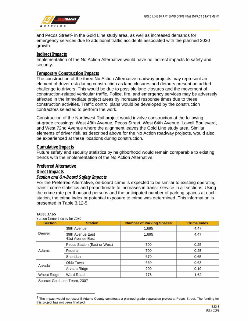
Preferred Alternative Direct Impacts Station and On-Board Safety Impacts For the Preferred Alternative, on-board crime is expected to be similar to existing operating transit crime statistics and proportionate to increases in transit service in all sections. Using the crime rate per thousand persons and the anticipated number of parking spaces at each station, the crime index or potential exposure to crime was determined. This information is presented in Table 3.12-5.
TABLE 3.12-5 Station Crime Indices for 2030
Section Station Number of Parking Spaces Crime Index 38th Avenue 1,695 4.47
Denver 39th Avenue East 41st Avenue East
1,695 4.47
Pecos Station (East or West) 700 0.25 Federal 700 0.25 Adams
Sheridan 670 0.65 Olde Town 650 0.63
Arvada Arvada Ridge 200 0.19
Wheat Ridge Ward Road 775 1.62 Source: Gold Line Team, 2007
1 The impact would not occur if Adams County constructs a planned grade separation project at Pecos Street. The funding for this project has not been finalized.

GOLD LINE DRAFT ENVIRONMENTAL IMPACT STATEMENT
3.12-6 JULY 2008
Table 3.12-5 shows that the two areas with the highest potential exposure to crime are the Denver Section stations and the Ward Road Station. The stations with the lowest potential exposure to crime are those in Arvada and Adams County. The crime conditions at any of the Denver Section stations options would be the same since the station locations are within two blocks of one another.
Police, Fire, and Emergency Response Time Impacts Police, fire, and emergency services may be slightly affected by increased response times during peak hours due to increased congestion at the 172 at-grade crossings required for the Preferred Alternative. Because RTD would provide a high degree of safety improvements at each grade crossing, including gates and signal improvements, the potential for collisions with emergency vehicles is small. However, it is possible that some additional congestion at these locations would be experienced by emergency vehicles.
Indirect Impacts Implementation of the Preferred Alternative is not anticipated to indirectly affect crime rates any differently than the No Action Alternative. Future neighborhood crime would be representative of the surrounding area, with or without the implementation of the Preferred Alternative.
Temporary Construction Impacts The impact on emergency response times during construction of the 172 required at-grade crossings is a potential concern with the Preferred Alternative. It is possible that there would be some reduction in traffic capacity at some point during construction. Flaggers would be available to direct traffic during the construction across traveled roadways.
Cumulative Impacts Future safety and security statistics by neighborhood would remain comparable to existing trends with the implementation of the Preferred Alternative.
3.12.4 Avoidance and Minimization
The RTD design, construction, and operations standards for new transit systems, including the Preferred Alternative, incorporate several components and actions to make the systems safe and secure for transit patrons and the general public. A hazard identification, analysis, and resolution process is required for all transit engineering projects. Hazards are identified through a Preliminary Hazard Analysis to define hazards and their effects. In addition, a safety certification process is required to verify that system elements comply with a formal list of safety requirements for the transit mode.
RTD would work with police, fire, and transportation agencies during project design to ensure reliable emergency access is maintained. To minimize the impact on emergency response times, RTD would commit to maintain at least one open lane of traffic on affected north-south arterials during construction. Alternative plans or routes would be developed if needed to avoid delays in emergency response times.
Fencing or barriers would be provided along the proposed alignment and surrounding station areas. These would be designed to be a safety barrier to prevent trespassers, vehicles, trucks, and other roadway users from entering the trackway. These would also be designed to prevent road debris or plowed snow, slush, and ice from entering the trackway or station areas. Safety measures would be incorporated on elevated sections to provide fall protection as well as adequate space for maintenance workers.
2 There are 19 at-grade crossings in the Gold Line study area; two are part of the Northwest Rail project under the No Action Alternative.
GOLD LINE DRAFT ENVIRONMENTAL IMPACT STATEMENT
3.12-7 JULY 2008
All stations would be designed with a minimum of two access and egress points. These points would facilitate safe and efficient evacuation of a station in 4 minutes or less.
Surveillance would include both personal and video surveillance. Video surveillance systems would be capable of transmitting real-time video to RTD via a fiber optic transmission backbone or other suitable transmission network. Personal surveillance would include uniformed officers who inspect transit stations on a recurring basis.
Emergency telephones would be installed onsite. Emergency telephones would be consistent with existing RTD units and would meet performance requirements of RTD’s existing emergency telephone network. Emergency telephones would cover station platforms, elevator waiting areas, stairwell entries, parking structures, pedestrian tunnels, and pedestrian bridges.
Crime Prevention through Environmental Design (CPTED) would be incorporated in the entire design. The purpose of CPTED is to minimize potential threats and vulnerabilities to the transit system, facilities, and patrons and maximize safety and security through engineering and design. Some CPTED strategies would include:
• Maximizing the visibility of people, parking areas, patron flow areas, and building/ structure areas.
• Providing adequate lighting to minimize shadows.
• Installing graffiti guards and removing graffiti when discovered.
• Installing Mylar shatter guard protection for glass windows.
• Installing landscaping that maximizes visibility.
• Providing gateway treatments, decorative fencing, perimeter control, and a minimum number of parking structure access points.
• Coordinating and cooperating with municipalities to promote transit-friendly land uses (avoiding land uses that have links to crime).
• Establishing maintenance programs that repair broken windows, pick-up litter, and manage streetscapes and public spaces.
Design elements and electronic technology would be used to ensure the transit platform area is safe and free of hazards. Representative measures include:
• Active and passive warning devices that alert persons of risks and hazards.
• Light Emitting Diode flashing pedestrian warning signs that warn of an approaching train.
• Pavement coloring and texturing to notify pedestrians of hazards and/or risk areas.
• Pedestrian bafflers such as swing gates, automatic pedestrian gates, or Z-crossings on platforms with poor sight distance to prevent pedestrians from entering the railway.
An internet-based local information network would be created to serve a variety of needs. It would provide promotional opportunities; real-time transit information; updates on construction, route closures, and alternative route information; and other transportation information and services. The network would be coordinated with state and regional Intelligent Transportation Systems projects.
GOLD LINE DRAFT ENVIRONMENTAL IMPACT STATEMENT
3.12-8 JULY 2008
RTD would work with local police and sheriff’s departments to plan for appropriate security forces and would increase the number of private security guards on patrol within the corridor proportionate to the increase in service.
Additional safety and security measures would be undertaken during construction to reduce the impact on the public, including:
• Producing Traffic Management Safety Reports and Traffic Control Plans for each phase of construction.
• Accounting for the poor air quality season (November 1 to March 1).
• Keeping transit operating at existing stops where possible.
• Keeping bike and pedestrian facilities continuous.
• Ensuring the contractor obtains permits and approvals by local governments for all detours.
• Providing signing plans (sign continuity must be maintained and advance warning of any closure provided at least 7 days in advance).
• Providing pavement marking plans to maintain access and circulation in construction areas.
• Providing temporary signalization plans in coordination with RTD, local agencies, and utility providers.
3.12.5 Mitigation Measures No mitigation is required beyond adherence to RTD Safety and Security design standards. RTD will convene a Fire and Life Safety Committee that will assist in preparing an emergency plan and coordinate response to emergency situations.

3.13U
tilities

GOLD LINE DRAFT ENVIRONMENTAL IMPACT STATEMENT
3.13-1 JULY 2008
3.13 0BUtilities
3.13.1 1BIntroduction to Analysis
3.13.1.1 5BSummary of Results The analysis shows that implementation of the Preferred Alternative would require as many as 26 major utility relocations for the construction of the trackway and up to an additional 52 major utility relocations for construction of the stations.
By comparison, the extent of utility relocations for the three roadway projects under the No Action Alternative cannot be estimated at this time because no engineering has been done for these projects. The construction of the Northwest Rail project under the No Action Alternative would require as many as 18 major utility relocations.
3.13.1.2 6BPurpose Utility relocation analysis is important for three reasons:
• The construction of a project across utilities could result in the release of sewage, natural gas, or other contaminants to the environment, as well as loss of service to local customers.
• Preliminary design has been based on this analysis to identify potential conflicts and recommend areas for further investigation and coordination with utility companies during later stages of the project.
• Utility relocation can be a significant cost to the proposed project, so it is important to identify opportunities to avoid these relocations.
3.13.2 2BAffected Environment The major utilities identified in the Gold Line study area include fiber, telephone, low voltage electric lines, high voltage electric transmission (ELT) lines, buried water and gas lines, sanitary and storm sewers, and irrigation ditches. The following provides general information for each type of major utility.
9BDenver Section The Denver Section contains the Railroad Alignment and East Direct Design Option. These two alignments are within about 300 feet of each other in a north-south direction. This area has a long history of industrial and commercial development, and as a result, has many old utility crossings as well as more recent utilities. These utilities include storm sewers ranging from 66 inches to 72 inches in diameter, two Metro Wastewater sanitary sewers from 70 to 78 inches in diameter, a 20-inch raw water line, the Farmers and Gardeners Ditch, several buried fiber optic lines, a high-pressure gas line, the Xcel Argo substation, Xcel overhead and underground electric lines, overhead and underground communication lines, and underground low- and intermediate-pressure gas lines.
There are three station options in the Denver Section depending on the alignment selected. There are more utilities at the 38th Avenue Station and 39th Avenue East Station locations than found at the 41st Avenue East Station location. These include: Denver Wastewater 42-inch and 66-inch storm sewers, an 18-inch sanitary sewer, Level 3 fiber optic line, Xcel low- and intermediate-pressure lines, Qwest overhead and underground communication lines, and Xcel overhead and underground electric lines. At the 41st Avenue East Station there

GOLD LINE DRAFT ENVIRONMENTAL IMPACT STATEMENT
3.13-2 JULY 2008
are two Denver Wastewater 8-inch sewers, Level 3 fiber optic line, Qwest overhead and underground communication lines, and Xcel overhead and underground electric lines.
10BAdams Section In the Adams Section, the Railroad Alignment and East Direct Design Option have similar utility issues. The Railroad Alignment runs through the Utah Junction rail yard and the East Direct Design Option is located adjacent to the rail yard through commercial and industrial land uses. The Suncor high pressure gas line, Denver Water 66-inch water line and the Fisher Ditch are located in this area.
Just east of Sheridan Boulevard, the BNSF/UP alignment separates and the Preferred Alternative follows the BNSF Railway Company ROW to the west. The major utilities that cross or run parallel to the proposed alignment in the Adams Section include numerous storm sewers ranging from 36 inches to 68 inches in diameter, two drainage culverts, raw water lines, Manhart Ditch, Jim Baker Outlet Ditch, Fisher Ditch, Kershaw Ditch, a communications fiber trench, overhead and underground communications lines, Qwest overhead and buried fiber optic lines, Xcel overhead and underground electric lines, and Xcel underground low-and intermediate-pressure gas lines.
Two stations would be located in the Adams Section at Pecos Street and Federal Boulevard. The Pecos Station has two options: Pecos East and Pecos West. While both stations include utilities, neither offers an advantage over the other. Utilities at the Federal Station are limited to on Xcel overhead electric line and one Qwest overhead communication line.
11BArvada Section In the Arvada Section, the Preferred Alternative continues to follow the BNSF Railway Company ROW through many residential and commercial developments. The major utilities in the Arvada Section include numerous storm sewers ranging from 30 to 60 inches in diameter, many sanitary sewers ranging from 8 to 10 inches in diameter, Pachello Lateral Ditch, Wadsworth Ditch, Wadsworth Lateral Ditch, Swadley Ditch, Allen Rend Ditch, fiber optic lines, overhead and underground low-voltage electric lines, overhead and underground communication lines, and underground low- and intermediate-pressure gas lines.
Three stations are proposed in the Arvada Section: Sheridan, Olde Town, and Arvada Ridge. Utilities in the Olde Town Station footprint include 10-inch vitreous clay pipe (VCP) sanitary sewers, a 36-inch storm sewer, Swadley Ditch, buried and overhead communication lines, low-pressure gas lines, overhead and buried electric lines, and Manhart Ditch.
12BWheat Ridge Section In the Wheat Ridge Section, residential neighborhoods and commercial developments border the BNSF Railway Company ROW. The major utilities in the Wheat Ridge Section include numerous 8- to 10-inch sanitary sewers, Juchem/Reno Ditch, a high-pressure gas line, fiber optic lines, Ridge substation ELT lines, overhead and underground low-voltage electric lines, overhead and underground communication, and underground low- and intermediate-pressure gas lines.
The Ward Road Station is the only station within the Wheat Ridge Section of the Gold Line study area. Utilities in the Ward Road Station footprint include an 8-inch sanitary sewer and a storm sewer.

GOLD LINE DRAFT ENVIRONMENTAL IMPACT STATEMENT
3.13-3 JULY 2008
3.13.3 3BImpact Evaluation
3.13.3.1 7BMethodology The utility impact evaluation included:
• Contacting the Utility Notification Center of Colorado for initial identification of private utility companies and municipalities with facilities in the Gold Line study area.
• Contacting the identified companies and departments to obtain maps or verbal descriptions of the facilities. Follow-up field reconnaissance and review of US Geological Survey topographic maps confirmed the findings and provided additional information that was compiled into a contact list, utility tables organized by section and ownership, impact and mitigation tables organized by section and ownership, and utility maps.
• Identifying major utilities based on their critical nature or potential high cost and complexity of relocation.
• Utilities identified included: telecommunications networks (buried telephone and fiber optic lines), overhead electric and telephone, cell phone towers, irrigation ditches, water lines 24 inches or larger in diameter, sanitary sewer lines 18 inches or larger in diameter or any size if constructed of brick/clay, storm sewers or culverts 36 inches or larger in diameter, gas transmission lines, natural gas pipelines, petroleum lines, pump or meter stations, electric substations, and high-voltage lines (ELT lines).
• Identifying potential utility conflicts and comparing them to the Gold Line footprint with the locations of utilities as plotted on the utility map. The maximum excavation depth required to construct tracks at grade was assumed to be 4 feet. Utilities were assumed to be impacted if they crossed the proposed alignment footprint; ran parallel to and inside of the proposed alignment footprint; were located within a station footprint; were unable to function normally; were inaccessible; were not able to maintain sufficient clearance; or could have ruptured or disrupted service.
• Evaluating both relocations and adjustments in terms of possible disruptions in service or endangerment to human health and the environment from rupture that could result during either action. It is expected that all utility impacts would be short term, these would be addressed prior to or during construction by relocation or adjustment, and there would be no rupturing of gas, sanitary, sewer, or water lines.
3.13.3.2 8BResults
13BNo Action Alternative The No Action Alternative assumes that existing and committed improvements, as defined in Chapter 2, Alternatives Considered, would be implemented by others as planned.
15BUDirect Impacts Roadway Projects Implementation of the two roadway projects and the reconstruction of the I-70/Kipling interchange would require the proportionate expansion of existing storm sewer systems to accommodate increased storm flows. Other than construction effects discussed below, utilities such as water and wastewater, communications systems, and electric power would be unaffected.

GOLD LINE DRAFT ENVIRONMENTAL IMPACT STATEMENT
3.13-4 JULY 2008
Northwest Rail Project Since the Northwest Rail project would be constructed prior to the Gold Line, the impacts resulting from the shared trackway from DUS to Pecos Street are attributed to the former project.
With either the Railroad Alignment Option or the East Direct Design Option, the impacts to utilities are greatest in areas that are cut or filled, and where bridge structures and bridge abutments would be constructed. Adjustments to ditch crossings, manholes, valves, and vaults may be required throughout the proposed alignment ROW. As shown in Table 3.13-1, there are 18 potential utility relocations associated with constructing the alignment between DUS and Pecos Street. These potential conflicts are depicted in Figure 3.13-1. These impacts are comparable between the Railroad Alignment Option and the East Direct Design Option because the majority of conflicts are perpendicular (cross at 90 degrees, rather than parallel) to the alignments. It is anticipated that some portion of these relocations can be avoided with additional engineering design.
There are no station-related utilities impacts associated with the Northwest Rail project in the Gold Line study area.
16BUIndirect Impacts There are no indirect impacts on utilities associated with the No Action Alternative.
17BUTemporary Construction Impacts The impacts of the No Action Alternative roadway projects are unknown. As discussed above, construction of the Northwest Rail project could require 18 utility relocations.
18BUCumulative Impacts Utility needs are directly correlated to increases in population; changes in density can also require the expansion of infrastructure facilities. The demand for new utilities in both the study area and the region would be driven by the increase in population predicted in DRCOG’s 2030 population forecast. If future land use patterns repeat past land use patterns then the majority of this new population would occur in comparatively low-density, single-family residential land uses where new utility infrastructure is more costly per dwelling unit basis.
14BPreferred Alternative 19BUDirect Impacts DUS to Pecos Street As discussed above, the Preferred Alternative for the Gold Line shares the alignment from DUS to Pecos Street with the Northwest Rail project. The impacts on utilities in this section of the alignment are discussed above. The impacts of the system electrification and stations associated with the Preferred Alternative are discussed later in this section.
The catenary system required for the Gold Line would most likely affect both overhead and underground utilities along the entire 11.2 mile alignment. Depending on the required depth of the pile foundations used in the construction of the catenary system, utilities buried directly beneath the footings may need to be relocated or the footing locations may need to be adjusted to avoid utilities. The catenary wire height is typically 19.5 feet tall, but can reach a maximum height of 23.5 feet at station locations. Additionally, the catenary pole heights are typically 4 feet higher than the contact wire. As a result, the catenary system may impact overhead utilities running along or crossing the proposed alignment.

GOLD LINE DRAFT ENVIRONMENTAL IMPACT STATEMENT
3.13-5 JULY 2008
FIGURE 3.13-1 Possible Utility Relocations in the Gold Line Study Area
Location Impact 1 Fiber optic paralleling 2 Fiber optic paralleling 3 Fiber optic paralleling
4 72-inch storm sewer crossing and paralleling
5 Fiber optic crossing and paralleling 6 >20-inch raw water crossing 7 38-inch storm sewer crossing 8 Fiber optic paralleling 9 66-inch storm sewer crossing
10 Fiber optic paralleling 11 24-inch water paralleling 12 42-inch storm sewer crossing 13 36-inch water crossing 14 48- to 54-inch storm sewer crossing 15 HP gas crossing and paralleling 16 66-inch water crossing 17 Fisher Ditch crossing 18 Fiber optic paralleling
19 Proposed drainage structure crossing
20 OH fiber optic crossing and paralleling
21 10-inch VCP water crossing 22 48-inch storm sewer crossing 23 Fiber optic crossing 24 Drainage channel paralleling 25 OH fiber optic crossing 26 OH fiber optic crossing 27 OH fiber optic crossing 28 Jim Baker Outlet Ditch paralleling 29 Kershaw Ditch crossing 30 43- to 68-inch storm sewer crossing 31 36- to 60-inch storm sewer crossing 32 36- to 60-inch storm sewer crossing 33 36-inch storm sewer crossing 34 36-inch storm sewer crossing
35 8-inch VCP sanitary sewer paralleling
36 Fiber optic crossing 37 Wadsworth Ditch paralleling 38 Fiber optic crossing 39 Allen Rend Ditch paralleling 40 36-inch storm sewer paralleling 41 48-inch storm sewer crossing 42 HP gas paralleling 43 Juchem/Reno Ditch paralleling
44 8-inch VCP sanitary sewer paralleling

GOLD LINE DRAFT ENVIRONMENTAL IMPACT STATEMENT
3.13-6 JULY 2008
TABLE 3.13-1 Summary of Potential Major Utility Conflicts for the No Action Alternative: Northwest Rail and Gold Line Alignment
Location Utility ID Number Possible Relocations No Action Alternative: Northwest Rail
Denver Section 1 Fiber optic paralleling 2 Fiber optic paralleling 3 Fiber optic paralleling 4 72-inch storm sewer crossing and paralleling 5 Fiber optic crossing and paralleling 6 >20-inch raw water crossing 7 38-inch storm sewer crossing 8 Fiber optic paralleling 9 66-inch storm sewer crossing 10 Fiber optic paralleling 11 24-inch water paralleling 12 42-inch storm sewer crossing 13 36-inch water crossing 14 48- to 54-inch storm sewer crossing Adams Section 15 HP gas crossing and paralleling 16 66-inch water crossing 17 Fisher Ditch crossing 18 Fiber optic paralleling Total: 18 Relocations
Preferred Alternative: Alignment West of Pecos Street to Ward Road 19 Proposed drainage structure crossing 20 OH fiber optic crossing and paralleling 21 10-inch VCP water crossing 22 48-inch storm sewer crossing 23 Fiber optic crossing 24 Drainage channel paralleling 25 OH fiber optic crossing 26 OH fiber optic crossing 27 OH fiber optic crossing 28 Jim Baker Outlet Ditch paralleling 29 Kershaw Ditch crossing 30 43- to 68-inch storm sewer crossing 31 36- to 60-inch storm sewer crossing 32 36- to 60-inch storm sewer crossing 33 36-inch storm sewer crossing 34 36-inch storm sewer crossing 35 8-inch VCP sanitary sewer paralleling 36 Fiber optic crossing 37 Wadsworth Ditch paralleling 38 Fiber optic crossing 39 Allen Rend Ditch paralleling 40 36-inch storm sewer paralleling 41 48-inch storm sewer crossing 42 HP gas paralleling 43 Juchem/Reno Ditch paralleling 44 8-inch VCP sanitary sewer paralleling Total: 26 Relocations
Preferred Alternative: Stations 38th Avenue NA One 66-inch storm sewer
One 18-inch sanitary sewer One fiber optic line One low-pressure gas line Three overhead electric lines Three overhead communication lines Four underground communication lines Total: 14 relocations

GOLD LINE DRAFT ENVIRONMENTAL IMPACT STATEMENT
3.13-7 JULY 2008
Location Utility ID Number Possible Relocations 39th Avenue East NA One 66-inch storm sewer
One 18-inch sanitary sewer One fiber optic line One low-pressure gas line Three overhead electric lines Three overhead communication lines Four underground communication lines Total: 14 relocations
41st Avenue East NA One fiber optic line Two overhead electric lines Two underground communication lines Three overhead communication lines Total: 8 relocations
Pecos East NA One ELT tower One underground electric line One low-pressure gas line One intermediate-pressure gas line One VCP sanitary sewer Total: 5 relocations
Pecos West NA One overhead ELT Fisher Ditch Four overhead electric lines Six overhead communication lines One low-pressure gas line Total: 13 relocations
Federal NA One overhead electric line Two overhead communication lines One low-pressure gas line Total: 4 relocations
Sheridan NA Manhart Ditch Two overhead electric lines Three underground electric lines One underground communication line One low-pressure gas line Total: 8 relocations
Olde Town NA One 10-inch VCP sanitary sewer One 36-inch storm sewer One underground electric line One underground communication line One low-pressure gas line Total: 5 relocations
Arvada Ridge NA Swadley Ditch One underground electric line Two overhead electric lines One underground communication line One low-pressure gas line Total: 6 relocations
Ward Road NA One 8-inch VCP sanitary sewer One storm sewer Total: 2 relocations
GOLD LINE DRAFT ENVIRONMENTAL IMPACT STATEMENT
3.13-8 JULY 2008
An electric substation (north of the 38th Avenue Station) would be constructed outside of the proposed alignment footprint to provide the power needed to operate the EMU system. In addition, one small paralleling station would be installed along the proposed alignment to boost the power in the contact wire of the catenary system (most likely near or at the Sheridan Station). Impacts to existing utilities would be evaluated when the location of the paralleling station is determined. As a result of the substations and the paralleling station, the Preferred Alternative would not cause additional demand on nearby power sources.
Regarding stations, the 41st Avenue East Station is anticipated to require eight utility relocations, as shown on Table 3.13-1. The 38th Avenue and the 39th Avenue East Station options would each require relocations of 14 utilities. The Pecos East and the Pecos West stations would require 5 and 13 utility relocations, respectively.
Pecos Street to Ward Road The Preferred Alternative is anticipated to require utility relocations along its entire alignment. These include storm and sanitary sewers, fiber optic lines, irrigation ditches, and electric power lines. The most challenging, from a construction standpoint, is where the alignment crosses major sanitary or storm sewers due to the large amount of excavation required to relocate these facilities. As shown on Figure 3.13-1, there are several large storm sewers in the Adams and Arvada Sections that may need to be relocated. Relocation of the Jim Baker and the Kershaw ditches in the Adams Section and the Allen Rend and Wadsworth ditches in the Arvada Section would also require careful construction.
Station construction is anticipated to involve the following utility relocations:
• Federal: 4 relocations • Sheridan: 8 relocations • Olde Town: 5 relocations • Arvada Ridge: 6 relocations • Ward Road: 2 relocations
20BUIndirect Impacts There would be an increase in the amount of impervious surfaces throughout the Gold Line study area as a result of the parking lots and parking structures that would be constructed at each station location. The volume of storm runoff would increase because water would be unable to saturate into the ground, causing more runoff and drainage issues. Therefore, additional storm sewers may need to be installed. In addition, increases in population related to TOD would probably require more utilities near stations.
21BUTemporary Construction Impacts All of the direct utility impacts discussed above are temporary construction impacts. Because the engineering for the Preferred Alternative is not complete, the effects on utilities can only be generally described. Some utilities would be relocated during construction, while others may be relocated prior to construction, assuming good coordination with utility owners. Although utility relocations and adjustments are typically a cost issue, temporary disruptions to service may affect local residents and businesses.
22BUCumulative Impacts The construction of the Preferred Alternative or the other FasTracks project elements would have a slight positive impact on utility investment due to increased population density around the proposed transit stations, resulting on a lower per capita cost for utilities.
GOLD LINE DRAFT ENVIRONMENTAL IMPACT STATEMENT
3.13-9 JULY 2008
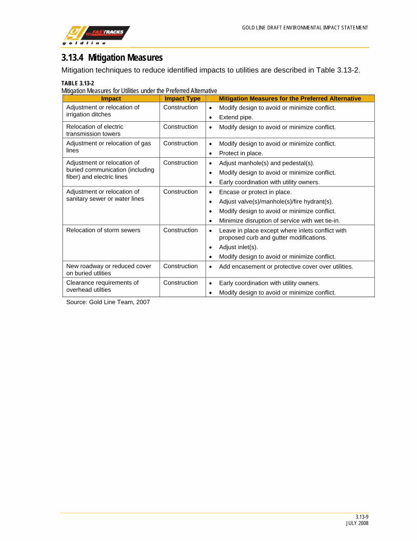
3.13.4 Mitigation Measures Mitigation techniques to reduce identified impacts to utilities are described in Table 3.13-2.
TABLE 3.13-2 Mitigation Measures for Utilities under the Preferred Alternative
Impact Impact Type Mitigation Measures for the Preferred Alternative Adjustment or relocation of irrigation ditches
Construction • Modify design to avoid or minimize conflict. • Extend pipe.
Relocation of electric transmission towers
Construction • Modify design to avoid or minimize conflict.
Adjustment or relocation of gas lines
Construction • Modify design to avoid or minimize conflict. • Protect in place.
Adjustment or relocation of buried communication (including fiber) and electric lines
Construction • Adjust manhole(s) and pedestal(s). • Modify design to avoid or minimize conflict. • Early coordination with utility owners.
Adjustment or relocation of sanitary sewer or water lines
Construction • Encase or protect in place. • Adjust valve(s)/manhole(s)/fire hydrant(s). • Modify design to avoid or minimize conflict. • Minimize disruption of service with wet tie-in.
Relocation of storm sewers Construction • Leave in place except where inlets conflict with proposed curb and gutter modifications.
• Adjust inlet(s). • Modify design to avoid or minimize conflict.
New roadway or reduced cover on buried utlities
Construction • Add encasement or protective cover over utilities.
Clearance requirements of overhead utilties
Construction • Early coordination with utility owners. • Modify design to avoid or minimize conflict.
Source: Gold Line Team, 2007