Embed Size (px)
Citation preview

County of HawaiiWater Use & Development Plan UpdateKeauhou & Waimea Aquifer Systems
County of HawaiiDepartment of Water Supply
Jon Nishimura, P.E.Fukunaga & Associates, Inc.
August 2015
3rd Annual Joint Government Water Conference“Implementing Hawaii Water Plans”

Presentation Outline
Background – 2010 Hawaii County WUDP
Plan Update - Objective & Goals
Technical Approach – Refinements
Issues

Background
Hawaii County Water Use & Development Plan
Updated original WUDP prepared in 1990
Initiated in 2004
Final Draft Plan 2010
Adopted by County Ordinance – February 2011
Accepted by CWRM – November 2011

Key Issues Identified
Assessment of Land Use Plans and Policies
Development of planning projections of water use
Projected water use by Agriculture
Background

Background
Findings and Recommendations
Conducted the initial island-wide assessment
Identification of “more sensitive” and “less sensitive” areas
Priority focus on more “sensitive” areas
Hualalai Aquifer Sector – Keauhou Aquifer System
West Mauna Kea Aquifer Sector – Waimea Aquifer System

County WUDP Objective
. . . to set forth the allocation of water to
land use through the development of policies
& strategies to guide the County in its
planning, management and development of
water resources to meet projected demands.

Key Goals
Provide guidance for the management of the island’s water resources to ensure that future water needs of the County are met, while preserving the integrity of the island’s water resources.
Ensure that sustainable water resources are integrated into the formulation and development of land use policies by the County.

Public Trust Doctrine – …waters of the State are held for the benefit of the citizens of the State.
Water is a most precious resource & shall be used wisely – to be conserved; not wasted
Highest quality water shall be used for the community’s highest beneficial uses
Lower quality water (reuse water, surface water, brackish water) should be used whenever feasible
Technical ApproachGuiding Principles

Assessment of Land Use Policies
Initial Assessment(Uniform Island-wide Comparison) Preliminary evaluation of sustainability of land use
policies
Identification of “more sensitive” and “less sensitive” areas
Concept of “Full Build-out” scenarios
Application of standard water planning methods to existing land use plans and policies
Focus on domestic demands and groundwater sources
Full Build-out Scenario – ALL land area to be developed to its theoretical maximum extent

Land Use Policies
State Land Use Classifications Generalized Land Use Policies
County General Plan – LUPAG Land Use Pattern Allocation Guide
Ultimate Development “County Vision”
Community Development Plans – “Local Area Vision”
County Zoning Allowable Development “authorized” by Ordinance
Need permits and regulatory approvals

GENERAL PLAN FULL BUILD-OUT SCENARIO
EXISTING ZONING BUILD-OUT SCENARIO
SUSTAINABILITY OF LAND USE POLICIES
SUSTAINABLE YIELD (WRPP)
DEM
AN
D/S
UST
AIN
AB
LE Y
IELD
(M
GD
)

SUSTAINABLE YIELD (WRPP)
EXISTING ZONING BUILD-OUT SCENARIO
SUSTAINABILITY OF LAND USE POLICIES
GENERAL PLAN FULL BUILD-OUT SCENARIO
DEM
AN
D/S
UST
AIN
AB
LE Y
IELD
(M
GD
)

SUSTAINABLE YIELD (WRPP)
EXISTING ZONING BUILD-OUT SCENARIO
SUSTAINABILITY OF LAND USE POLICIES
GENERAL PLAN FULL BUILD-OUT SCENARIO
DEM
AN
D/S
UST
AIN
AB
LE Y
IELD
(M
GD
)

Initial Assessment Considerations It is understood that the assessments are highly conservative – objective
is to identify the more sensitive and less sensitive areas on the island.
Sustainable yield values from WRPP are conservative estimates that establish safe limits to avoid degradation of the ground water resources.
Full build scenarios are inherently conservative, based on gross areas, irrespective of development limitations.
Typically, if an area is deemed less sensitive, the water resources in the area are well within sustainable limits to accommodate the potential development.
If areas are found to be more sensitive, more refined analyses of existing development is conducted, and adjustments to future development can be implemented if necessary.
Full Build-out Scenario – ALL land area to be developed to its theoretical maximum extent

CWRM Aquifer Sectors & Systems
801 – KOHALA
806 – SW MAUNA LOA
803 – W MAUNA KEA
807 – NW MAUNA LOA
809 – HUALALAI 804 – NE MAUNA LOA
808 - KILAUEA
802 – E MAUNA KEA
805 – SE MAUNA LOA

Kohala
E Mauna Kea
NE Mauna Loa
Hualalai
SWMauna
Loa
SE Mauna Loa Kilauea
NW Mauna Loa
W Mauna Kea(Waimea)
Island of HawaiiCWRM Aquifer Sectors801
805 808
803
804
802
807
806
809
Abundant Sustainable Yield
Additional Study Warranted
(Keauhou)

Refinements - KeauhouIncorporation of New Planning Information
LUPAG Updates – County Planning Department
Kona Community Development Plan
Proposed and Recent Masterplan Developments

Refinements - KeauhouAssessment of Recent Developments Identification of existing users / developed parcels
Identify lands with “Anticipated Water Demand”
Water Entitlements Vacant parcels with service laterals Approved building permits DWS water committments/credits Developer agreements
Department of Hawaiian Home Lands needs (not already included in above) Public Facility needs (State Water Projects Plan) Kona Community Development Plan projects (not already included in
above)
Evaluation of water use trends – “unit rates” (typically based on metered data)
Conduct reality check of original water use projections


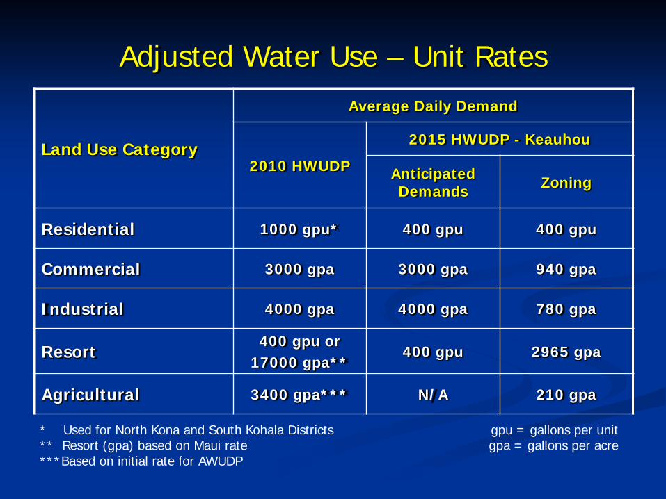
Adjusted Water Use – Unit Rates
Land Use Category
Average Daily Demand
2010 HWUDP
2015 HWUDP - Keauhou
Anticipated Demands
Residential 1000 gpu* 400 gpu
Commercial 3000 gpa 3000 gpa
Industrial 4000 gpa 4000 gpa
Resort400 gpu or
17000 gpa**400 gpu
Agricultural 3400 gpa*** N/A
* Used for North Kona and South Kohala Districts** Resort (gpa) based on Maui rate***Based on initial rate for AWUDP
gpu = gallons per unitgpa = gallons per acre

Anticipated Water Demand – Keauhou
Component CWRM CategoryWater Demand
(MGD)
Existing Developed Parcels Domestic/Irrigation/Municipal 14.68 *
Water Entitlements
Vacant service laterals Municipal 1.10
Developer agreements Municipal 3.39
Water credit commitments Municipal 2.66
Approved building permits Municipal 0.09
Other Developments Irrigation/Municipal 0.45
Department of Hawaiian Homes Irrigation/Municipal 3.40
State Projects Irrigation/Municipal 0.06
Kona Community Development Plan Municipal 1.85
TOTAL 27.86
* Pumpage records - highest 12 month – MAV – AUG 2012- JUL 2014

Refinements - KeauhouAssessment of Zoning Water Demand
Identification of existing users / developed parcels
Identify undeveloped zoned parcels
Residential, Commercial, Industrial, Resort, Agriculture
Identify lands not included in County Zoning and/or Water Service Area Department of Hawaiian Home Lands needs (not already included in
above)
Apply realistic regional – “unit rates” (typically based on metered data)
Conduct reality check of original water use projections


Adjusted Water Use – Unit Rates
Land Use Category
Average Daily Demand
2010 HWUDP
2015 HWUDP - Keauhou
Zoning
Residential 1000 gpu* 400 gpu
Commercial 3000 gpa 940 gpa
Industrial 4000 gpa 780 gpa
Resort400 gpu or
17000 gpa**2965 gpa
Agricultural 3400 gpa*** 210 gpa
* Used for North Kona and South Kohala Districts** Resort (gpa) based on Maui rate***Based on initial rate for AWUDP
gpu = gallons per unitgpa = gallons per acre

County Zoning Water Demand – Keauhou
Zoning District/ Component CWRM CategoryWater Demand
(MGD)
Existing Developed Parcels Domestic/Irrigation/Municipal 14.68 *
Residential Domestic/Irrigation/Municipal 4.31
Resort Irrigation/Municipal 0.57
Commercial Municipal 0.38
Industrial Industrial 0.91
Agricultural Agricultural 3.45
Other Developments Irrigation/Municipal 0.45
Department of Hawaiian Homes Irrigation/Municipal 3.40
TOTAL 28.33
* Pumpage records - highest 12 month – MAV – AUG 2012- JUL 2014
Adjusted Water Use – Unit Rates
Land Use Category
Average Daily Demand
2010 HWUDP
2015 HWUDP - Keauhou
Anticipated Demands Zoning
Residential 1000 gpu* 400 gpu 400 gpu
Commercial 3000 gpa 3000 gpa 940 gpa
Industrial 4000 gpa 4000 gpa 780 gpa
Resort400 gpu or
17000 gpa**400 gpu 2965 gpa
Agricultural 3400 gpa*** N/A 210 gpa
* Used for North Kona and South Kohala Districts** Resort (gpa) based on Maui rate***Based on initial rate for AWUDP
gpu = gallons per unitgpa = gallons per acre

Projected Water Demands
Establish baseline of existing water use (e.g. water meter records; monitoring; pumpage)
Project “infill” of undeveloped or under-developed lands (growth based on socio-economic activity)
Based on Population Growth Scenarios (low, medium & high – consistent with methods of County Planning Department)
Assume that types of future development in a given region will be similar in character with existing conditions.

Historical Groundwater Pumpage and Population Growth


GENERAL PLAN FULL BUILD-OUT SCENARIO
ZONING FULL BUILD-OUT SCENARIO
MEETING PROJECTED DEMANDS
SUSTAINABLE YIELD (WRPP)
DEM
AN
D/S
UST
AIN
AB
LE Y
IELD
(M
GD
)
PROJECTED WATER DEMAND
DEVELOPED SYSTEM CAPACITY
TIME
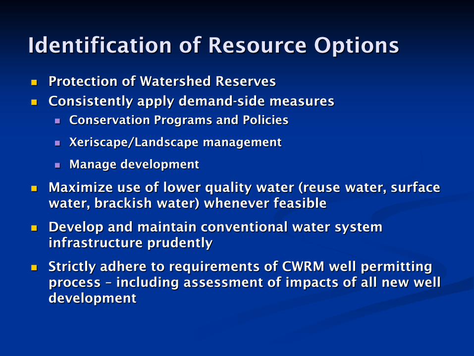
Identification of Resource Options
Protection of Watershed Reserves
Consistently apply demand-side measures Conservation Programs and Policies
Xeriscape/Landscape management
Manage development
Maximize use of lower quality water (reuse water, surface water, brackish water) whenever feasible
Develop and maintain conventional water system infrastructure prudently
Strictly adhere to requirements of CWRM well permitting process – including assessment of impacts of all new well development

Identification of data needs
Promote efforts to better understand the hydrogeological conditions
Awareness of Traditional and Cultural needs –identify sources of regional knowledge
Linking of land planning policies with infrastructure & resource availability
Public needs – State Water Projects Plan, County Public Facilities requirements
Private developer land plans – Kona Community Development Plan
Opportunity to Focus Future Efforts

Project Description
CWRM Conditional Approval – February 18, 2015
Updated Phase 1 PD submitted – March 4, 2015
Draft Phase 1 for Keauhou
Draft submitted to staff for review – May 15, 2015
Discussion/coordination between staff & County
Presentation to CWRM – August 2015
Draft Phase 2 for Keauhou
Draft PD submitted to staff for review – May 30, 2015
Discussion/coordination between staff & County
Tentative Schedule
![0f ljefu fli6«o b} lgs $ ljBfnosf $ hgfsf] egf{€¦ · Soni Magar 3.20 GPA Tilak Gurung 3.20 GPA Namuna Marasina 3.20 GPA Ashish Poudel 3.15 GPA Sahara Sarki 3.15 GPA Suman Thapa](https://img.dokumen.tips/doc/110x75/5f838171f6d5af02780c3f84/0f-ljefu-fli6o-b-lgs-ljbfnosf-hgfsf-egf-soni-magar-320-gpa-tilak-gurung.jpg)

![news fli6 «o b } lgs lje] · Rahul Gurung 3.05 GPA Sajan Rana 3.05 GPA Sunayana Thapa 3.05 GPA Monika Nepali 3.00 GPA Deepti Karki 2.75 GPA Rishabh Pokhrel Lil Bahadur Gurung Anshumala](https://img.dokumen.tips/doc/110x75/5e19d8602f66ec7047421094/news-fli6-o-b-lgs-lje-rahul-gurung-305-gpa-sajan-rana-305-gpa-sunayana-thapa.jpg)


![Barahipath, jif{ @@ c° ^$ @)&$ c;f/ g] 19 k[ ^±^≠!@ dNo ...apeksha thapa gpa: 3.70 kajal rai gpa: 3.70 rohan dahal gpa: 3.70 deewakar dahal gpa: 3.70 ishwor poudel gpa: 3.65 sonam](https://img.dokumen.tips/doc/110x75/5e9ce50a88852d7f7d5df312/barahipath-jif-c-cf-g-19-k-a-dno-apeksha-thapa.jpg)