Embed Size (px)
Citation preview

HARRIS COUNTY FLOOD CONTROL DISTRICT
GIS DATA FORMAT STANDARDS FOR DELIVERABLES
FEMA CLOMR / LOMR SUBMITTALS
5/5/2015
This document is to be followed by outside Agencies in formatting their Geographic Information System (GIS) data supporting their Federal Emergency Management Agency (FEMA) Conditional Letter of Map Revision (CLOMR) and Letter of Map Revision (LOMR) submittals to the specifications and requirements of the Harris County Flood Control District. Document Authored by: Richard Rogers (Sr GIS Technician IS-GIS Group)
Harris County Flood Control District 9900 Northwest Freeway Houston, TX 77092 phone: 713-684-4000
ENGINEERING AND CONSTRUCTION DIVISION DEVELOPMENT SERVICES

Harris County Flood Control District: FEMA CLOMR / LOMR GIS Submittals Page 1
Table of Contents
1.0 FEMA Submittal Geospatial Data Requirements
1.1 Overview ....................................................................................... 2 1.2 Purpose ......................................................................................... 2 1.3 Application …………………………………………………………….. 2 1.4 Projection ………………………………………………….....……….. 3 1.5 Topography ……………………………………………………..…….. 3 1.6 Topology ………………………………………………………..….….. 4 Figure1: Common Area Digitizing or Topology Errors……...…. 5
1.7 Coincident Features ………………………………………….………. 5 1.8 GIS Data Structure …………………………………………..…….…. 6
2.0 Format for Supporting GIS Data
2.1 S_BFE ........................................................................................... 7 2.2 S_FLD_HAZ_AR ........................................................................... 8-10 2.3 S_FLD_HAZ_LN .......................................................................... 11-12
Figure2: S_FLD_HAZ_LN line types …..…………………..…. 12 2.4 S_LOMR ....................................................................................... 13 2.5 S_WTR_LN ................................................................................... 14 2.6 S_XS ............................................................................................. 15-16 2.7 S_GEN_STRUCT ......................................................................... 17-18 2.8 S_TRNSPORT_LN ....................................................................... 19-20
3.0 Document Revisions ............................................................................... 21-22
4.0 Contact Information ................................................................................ 23

Harris County Flood Control District: FEMA CLOMR / LOMR GIS Submittals Page 2
1.0 FEMA Submittal Geospatial Data Requirements 1.1 Overview
Modifications to hydrologic or hydraulic models that necessitate the submission of a CLOMR or LOMR must be supported with appropriate geospatial information.
1.2 Purpose
The purpose of this subsection is to describe the requirements for geospatial information that must be submitted in support of studies that require preparation of a CLOMR or LOMR (revision or proposed revision to the effective Flood Insurance Rate Map [FIRM]), in addition to that required in direct support of hydrologic and hydraulic modeling.
1.3 Application
Update all relevant GIS data layers, including revisions to the 1% and 0.2% FEMA effective floodplains and FEMA floodway limits, for all submittals when proposed activities modify any or all of the following:
• Watershed drainage area boundaries • Subbasin drainage area boundaries • FEMA Effective Floodplain limits • FEMA Effective Floodway limits • Cross section location map
Update all relevant GIS data layers and modify the geospatial files distributed with the models checked-out for the study. In addition to the geospatial data requirements described in the previous section, submit geospatial data associated with the update of the floodplain mapping for a study.
The required layers include the following:
• 1% annual chance (100-year) floodplain (if applicable) • 0.2% annual chance (500-year) floodplain (if applicable) • Floodway (if applicable) • Revised base flood elevations (if applicable) • Added cross sections (if applicable) • Revised or added area water features (if applicable) • Revised or added linear water features (if applicable) • CLOMR / LOMR boundary feature (if applicable)

Harris County Flood Control District: FEMA CLOMR / LOMR GIS Submittals Page 3
1.4 Projection All GIS data supporting CLOMR / LOMR submittal are to be in projected grid coordinates. Data Type: ESRI Shapefile Geometry Type: Polygon, Line or Point Projected Coordinate System: NAD_1983_StatePlane_Texas_South_Central_FIPS_4204_Feet Projection: Lambert_Conformal_Conic False_Easting: 1968500.00000000 False_Northing: 13123333.33333333 Central_Meridian: -99.00000000 Standard_Parallel_1: 28.38333333 Standard_Parallel_2: 30.28333333 Latitude_Of_Origin: 27.83333333 Linear Unit: Foot_US Geographic Coordinate System: GCS_North_American_1983 Horizontal Datum North American Datum of 1983 Vertical Datum North American Vertical Datum (NAVD) 88 with 2001 adjustment Prime Meridian: Greenwich Angular Unit: Degree 1.5 Topography
Use the HCFCD LIDAR dataset (2001) with 2-foot contours as the base topographic data set for modeling purposes. This data is available from the HCFCD Planning department and is organized in tiles by USGS quarter quad. The 2001 LIDAR dataset meets the minimum accuracy requirements for use in FEMA studies. However, the data must be supplemented with survey data for use in hydraulic analysis. Use the 2001 LIDAR dataset provided by HCFCD for CLOMR and LOMR submissions. Other LIDAR datasets are not allowed except in the Addicks watershed. A study has been submitted to FEMA which will replace the effective information in the Addicks watershed. CLOMR and LOMR requests in Addicks watershed must currently analyze the effect of their request on the current effective condition and the submitted study condition. Analyses based on the submitted study must utilize the 2001 LiDAR flown in 2008 NUSA provided by H-GAC.
Note: Mapping proposed sites developed since 2001 may not be able to use the 2001 LIDAR dataset because the 2001 LIDAR does not reflect the change. In these cases, for a CLOMR use the conceptual plan or proposed design plans for the project, and for a LOMR use field surveyed topography or as-built survey data.

Harris County Flood Control District: FEMA CLOMR / LOMR GIS Submittals Page 4
1.6 Topology
The submitting Agency shall ensure that vector data files created meet the following data structure requirements:
• Digitized linework must be collected at a reasonably fine line weight. • Digitized Line features must be continuous (no dashes, dots, patterns, or hatching). • Area spatial features for a given theme must cover the entire study area without overlaps, under
laps or sliver polygons between adjacent polygons. • Files must be free of discontinuities such as overlapping lines, gaps, "turn backs," dangling lines
and duplicate elements. • Spatial files must not contain any linear or area patterns. • Gaps or overshoots between features that should close must be eliminated.
Logical consistency describes certain node-line-area relationships internal to the digital data. The Node-line-area relationship requirements that the submitting Agency must meet include the following:
• Areas will be represented by closed polygons, without overshoots or undershoots. • Unattributed polygons are not permitted, including “sliver” polygons that result from poor digitizing
methods. • Unnecessary nodes and vertices must be avoided. • Vertices should be placed conservatively when designing features so that only the minimal
number of vertices or nodes is used to create the desired shape with appropriate smoothness (e.g., a straight line should be defined with two nodes only).
• Lines must begin and end at nodes. • Lines must connect to each other at nodes. • Lines must not extend through nodes.
Topology Properties to Check in ArcGIS Feature Class Rule Feature Class
S_FLD_HAZ_LN Must Not Self-Overlap S_FLD_HAZ_LN Must Not Self-Intersect S_FLD_HAZ_LN Must Not Intersect Or Touch Interior S_FLD_HAZ_AR Must Not Overlap S_FLD_HAZ_AR Must Not Gaps S_FLD_HAZ_AR Boundary Must Be Covered By S_FLD_HAZ_LN S_FLD_HAZ_AR Must Be Covered By Feature Class Of S_LOMR
Topology Continued on next page

Harris County Flood Control District: FEMA CLOMR / LOMR GIS Submittals Page 5
Figure 1: Common Area Digitizing or Topology Errors
1.7 Coincident Features
Coincident features are those that share the same location or boundary, such as flood zone boundaries. These coincident features must superimpose, vertex (shape point) for vertex, within the files. The following pair of shape files have both area features and line features: S_FLD_HAZ_LN (line) and S_FLD_HAZ_AR (polygon). All spatial elements in the S_FLD_HAZ_LN must match exactly with the boundaries of the elements in the S_FLD_HAZ_AR.

Harris County Flood Control District: FEMA CLOMR / LOMR GIS Submittals Page 6
1.8 GIS Data Structure
Only newly created or modified Shapefile features, supporting the CLOMR / LOMR submittal, are to be submitted. Shapefiles submitted should only cover the geographical extent of CLOMR / LOMR area. All Shapefile names and Attribute Fields are to be in upper case and named as described in this manual. All Attribute Values for populated Text Fields should be upper case. For a Attribute Field that is required when applicable, but does not apply, the value should be Null (i.e. the field must be left empty, not set to zero). The submitting Agency shall use the value zero only when an attribute has the specific value of zero. Create the Attribute Fields as required for each GIS Shapefile required for CLOMR / LOMR submission and populate fields as completely and accurately as possible. Design plans in a CAD data format, such as AutoCAD or MicroStation, will need to be converted to the GIS data format required unless special circumstances do not permit. If unable to submit data in GIS format required or for any questions concerning formatting of GIS data, please contact the Harris County Flood Control District (at 3.0 Contact Information) before submittal.

Harris County Flood Control District: FEMA CLOMR / LOMR GIS Submittals Page 7
2.0 Format for Supporting GIS Data 2.1 S_BFE Required if CLOMR/LOMR involves the modification of the existing regulatory floodway, the effective Base Flood Elevations (BFEs), or the Special Flood Hazard Area (SFHA). Spatial file of location and attributes for base flood elevation lines. Data Type: ESRI Shapefile Geometry Type: Line The Base Flood Elevation (BFE) Shapefile is required for any newly added digital data where BFE lines will be shown on the corresponding Flood Insurance Rate Map (FIRM). The S_BFE Shapefile contains information about the BFEs within a study area. BFE lines indicate the rounded whole-foot water-surface elevation of the 1-percent-annual-chance flood. The spatial elements representing BFE features are lines extending from Special Flood Hazard Area (SFHA) boundary to SFHA boundary. The BFE lines will have no visible gaps or overshoots between the SFHA boundary and the end of the BFE line at the publication scale of the DFIRM. However, the ends of the BFE lines are not necessarily snapped precisely to the SFHA boundary. Each BFE is represented by a single line. While BFE lines are depicted as wavy lines on the hardcopy FIRM, they should be primarily straight lines in the spatial data.
S_BFE layer properties with required Field Names, Type, Length, Precision and Scale
Populated Fields DFIRM_ID: 48201C VERSION_ID: (Leave field empty) BFE_LN_ID: Use unique identifier to your data if applicable; otherwise (Leave field empty) ELEV: Base Flood Elevation. The rounded, whole foot elevation of the 1-percent- annual-chance flood LEN_UNIT: FEET V_DATUM: NAVD88 SOURCE_CIT: (Leave field empty)

Harris County Flood Control District: FEMA CLOMR / LOMR GIS Submittals Page 8
2.2 S_FLD_HAZ_AR Required if CLOMR/LOMR involves the modification of the existing regulatory floodway, the effective Base Flood Elevations (BFEs), or the Special Flood Hazard Area (SFHA). Spatial file of location and attributes for flood insurance risk zones. Data Type: ESRI Shapefile Geometry Type: Polygon The S_FLD_HAZ_AR Shapefile contains information about the flood hazards within the study area. These zones are used by the federal Emergency Management Agency (FEMA) to designate the Special Flood Hazard Area (SFHA) and for insurance rating purposes. These data are the flood hazard areas that are or will be depicted on the Flood Insurance Rate Map (FIRM). The spatial elements representing the flood zones are polygons. The entire area of the jurisdiction(s) mapped by the FIRM should have a corresponding flood zone polygon. There is one polygon for each contiguous flood zone designated. S_FLD_HAZ_AR layer properties with required Field Names, Type, Length, Precision and Scale
S_FLD_HAZ_AR Continued on next page

Harris County Flood Control District: FEMA CLOMR / LOMR GIS Submittals Page 9
Populated Fields DFIRM_ID: 48201C VERSION_ID: (Leave field empty) FLD_AR_ID: (Leave field empty) STUDY_TYP: SFHAs WITH HIGH FLOOD RISK FLD_ZONE: Flood zone designation value.
Value
ZONE DESCRIPTION
A Areas with at least a 1% annual chance of flooding and a 26% chance of flooding over the life of a 30-year mortgage. Because detailed analyses are not performed for such areas; no depths or base flood elevations are shown within these zones.
AE Areas with at least a 1% annual chance of flooding and a 26% chance of flooding over the life of a 30-year mortgage. The base floodplain where base flood elevations are provided.
AH Areas with at least a 1% chance of shallow flooding each year, usually in the form of ponding, with an average depth ranging from 1 to 3 feet. These areas have at least a 26% chance of flooding over the life of a 30-year mortgage. Average flood depths derived from detailed analyses are shown within these zones.
AO
River or stream flood hazard areas, and areas with at least a 1% chance of shallow flooding each year, usually in the form of sheet flow, with an average depth ranging from 1 to 3 feet. These areas have at least a 26% chance of flooding over the life of a 30-year mortgage. Average flood depths derived from detailed analyses are shown within these zones.
VE Coastal areas with at least a 1% chance of flooding and an additional hazard associated with storm waves. These areas have at least a 26% chance of flooding over the life of a 30-year mortgage. Base flood elevations derived from detailed analyses are shown at selected intervals within these zones.
X Area which has been determined to be outside the 1% annual chance flood.
ZONE_SUBTY: Flood Zone Subtype. This field captures additional information about the flood zones
not related to insurance rating purposes. For example, Zone X could have “AREA WITH REDUCED FLOOD RISK DUE TO LEVEE”, “AREA OF MINIMAL FLOOD HAZARD” or “0.2 PCT ANNUAL CHANCE FLOOD HAZARD” as a subtype. Types of floodways are also stored in this field.
S_FLD_HAZ_AR Continued on next page

Harris County Flood Control District: FEMA CLOMR / LOMR GIS Submittals Page 10
Value
SFHA_TF: Special Flood Hazard Area. If the area is within SFHA this field would be true. This
field will be true for any area that is coded for any A or V zone flood areas. It should be false for any X or D zone flood areas.
Value T – True F – False STATIC_BFE: Populate for areas that have been determined to have a constant Base Flood
elevation over a flood zone; Otherwise, -9999 (no value) V_DATUM: NAVD88 DEPTH: Populate Depth for Zone AO areas; Otherwise, -9999 (no value) LEN_UNIT: FEET VELOCITY: -9999 VEL_UNIT: (Leave field empty) AR_REVERT: (Leave field empty) AR_SUBTRV: (Leave field empty) BFE_REVERT: -9999 DEP_REVERT: -9999 DUAL_ZONE: (Leave field empty) SOURCE_CIT: (Leave field empty)
ZONE DESCRIPTION
0.2 PCT ANNUAL CHANCE FLOOD
HAZARD
The area of land that has a 0.2% annual chance of being inundated by flood waters from a bayou, stream or creek, or areas of 1% annual chance flood with average depths of less than 1 foot or with drainage areas less than 1 square mile. It is commonly referred to as the 500-year floodplain.
AREA OF MINIMAL FLOOD HAZARD
Area of minimal flood hazard, which has been determined to be outside the 500-year flood zone.
AREA WITH REDUCED FLOOD
RISK DUE TO LEVEE
Areas protected by levees from the 1% annual chance flood.
FLOODWAY Areas which are in the regulatory floodway.

Harris County Flood Control District: FEMA CLOMR / LOMR GIS Submittals Page 11
2.3 S_FLD_HAZ_LN Required if CLOMR/LOMR involves the modification of the existing regulatory floodway, the effective Base Flood Elevations (BFEs), or the Special Flood Hazard Area (SFHA). Spatial file of location and attributes for boundaries of flood insurance risk zones. Data Type: ESRI Shapefile Geometry Type: Line S_FLD_HAZ_LN layer properties with required Field Names, Type, Length, Precision and Scale
Populated Fields DFIRM_ID: 48201C VERSION_ID: (Leave field empty) FLD_LN_ID: (Leave field empty) LN_TYP: Line Type. These lines indicate the location of the flood boundary, limit of detailed
study, or the county boundary. Value SFHA / Flood Zone Boundary – Flood boundary Limit Lines – Limit of Detailed Study Other Boundary – Harris Co. boundary if in spatial extent of CLOMR/LOMR SOURCE_CIT: (Leave field empty)

Harris County Flood Control District: FEMA CLOMR / LOMR GIS Submittals Page 12
Figure 2: S_FLD_HAZ_LN line types

Harris County Flood Control District: FEMA CLOMR / LOMR GIS Submittals Page 13
2.4 S_LOMR Single bounding polygon to indicate LOMR areas that are to be incorporated into the Flood Insurance Rate Map (FIRM) or communicate areas of DFIRM data that were updated to reflect the results of LOMR’s. Spatial extent should encompass the area where any of the following conditions have occured: modification of the existing regulatory floodway, modification of the Special Flood Hazard Area (SFHA), modification of the 0.2% annual chance flood hazard area, added or revised base flood elevations, added or revised lettered cross sections, added or revised hydraulic structures, added or revised channel alignments or detention/retention features. Spatial file of location and attributes for boundary of CLOMR/LOMR. Data Type: ESRI Shapefile Geometry Type: Polygon S_LOMR layer properties with required Field Names, Type, Length, Precision and Scale
Populated Fields DFIRM_ID: 48201C VERSION_ID: (Leave field empty) LOMR_ID: (Leave field empty) EFF_DATE: (Leave field empty) CASE_NO: (Leave field empty) SCALE: This is the denominator of the effective LOMR scale as a ratio. 24000/1” = 2000’ map, 12000/1”=1000’, 6000/1”=500’ Value - 6000, 12000, 24000 STATUS: (Leave field empty) SOURCE_CIT: (Leave field empty)

Harris County Flood Control District: FEMA CLOMR / LOMR GIS Submittals Page 14
2.5 S_WTR_LN Required if new water features are created or pre-existing water features are realigned or modified due to CLOMR / LOMR. Spatial file of location and attributes for water features in CLOMR / LOMR area. Data Type: ESRI Shapefile Geometry Type: Polyline S_WTR_LN layer properties with required Field Names, Type, Length, Precision and Scale
S_WTR_LN Continued on next page
Populated Fields DFIRM_ID: 48201C VERSION_ID: (Leave field empty) WATER_LN_ID: (Leave field empty) WTR_NM: Surface Water Feature Name Value Use formal name if pre-exisiting. ex: D100-00-00 (Brays Bayou) For newly created features use (ex: Unnamed Channel, Unnamed Pond) SHOWN_FIRM: Shown on FIRM. If the water feature is shown on the FIRM, this field would be True. Value T – True F – False SHOWN_INDX: Shown on Index Map. If the water feature is shown on the Index Map, this field would
be True. Value T – True F – False SOURCE_CIT: (Leave field empty)

Harris County Flood Control District: FEMA CLOMR / LOMR GIS Submittals Page 15
2.6 S_XS Required if CLOMR / LOMR involves the modification of the existing regulatory floodway, the effective Base Flood Elevations (BFEs), the Special Flood Hazard Area (SFHA) and other hydraulic modeling of structures. These lines represent the locations of channel surveys performed for input into the hydraulic model used to calculate flood elevations. The spatial elements representing cross sections are lines generally extending from outside the floodplain, across the entire floodplain and out the other side. The location and shape of the lines should depict as accurately as possible the position of the cross section used. Data Type: ESRI Shapefile Geometry Type: Line S_XS layer properties with required Field Names, Type, Length, Precision and Scale
Populated Fields DFIRM_ID: 48201C VERSION_ID: (Leave field empty) XS_LN_ID: (Leave field empty) WTR_NM: Surface Water Feature Name Value Use formal name if pre-existing. [ex: D100-00-00 (Brays Bayou)] UNNAMED - newly created feature [ex: UNNAMED CHANNEL]

Harris County Flood Control District: FEMA CLOMR / LOMR GIS Submittals Page 16
STREAM_STN: Stream Station. This is the measurement along the stream to the cross-section location. Value Derived from hydraulic modeling (should correspond spatially with any existing upstream or downstream adjacent cross sections) START_ID: Start Identification. The station start describes the origin for the measurements in the STREAM_STN field. Value Found in START_ID field of pre-existing adjacent cross sections (Leave field empty) – for unstudied areas or if unable to locate adjacent Start Id XS_LTR: Value
Same lettered values as pre-existing/Effective FEMA XS if LOMR/CLOMR XS is located at same spatial (STREAM_STN) location
(Leave field empty) – for new or added XS or same non-lettered existing FEMA (STREAM_STN) location XS_LN_TYP: Cross-Section Line Type. Value LETTERED, MAPPED – if XS_LTR field has any value other than Null
NOT LETTERED, MAPPED – if XS_LTR field value is Null but the XS is being mapped on the FIRM or annotated FIRM NOT LETTERED, NOT MAPPED - if XS_LTR field value is Null and the XS is not being mapped on the FIRM or annotated FIRM
WSEL_REG: Regulatory Water-Surface Elevation for the 1-Percent-Annual-Chance Flood Event.
This is the precise water surface elevation of the base flood calculated at this cross section. This elevation exactly matches the elevation of the base flood in the Flood Profiles and the Floodway Data table. This number is determined during the engineering analysis for the study. This value should match the regulatory column in the Floodway Data table in the FIS report or the elevation from the corresponding flood profile if no Floodway Data table is published.
Value derived from hydraulic modeling analysis number value should be rounded to 2 digits right of decimal point (tenths) STRMBED_EL: -8888 LEN_UNIT: FEET V_DATUM: NAVD88 PROFSXS_TXT: (Leave field empty) MODEL_ID: (Leave field empty) SEQ: -9999 SOURCE_CIT: (Leave field empty)
Harris County Flood Control District: FEMA CLOMR / LOMR GIS Submittals Page 17
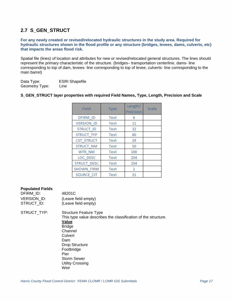
2.7 S_GEN_STRUCT For any newly created or revised/relocated hydraulic structures in the study area. Required for hydraulic structures shown in the flood profile or any structure (bridges, levees, dams, culverts, etc) that impacts the areas flood risk. Spatial file (lines) of location and attributes for new or revised/relocated general structures. The lines should represent the primary characteristic of the structure. (bridges– transportation centerline, dams- line corresponding to top of dam, levees- line corresponding to top of levee, culverts- line corresponding to the main barrel) Data Type: ESRI Shapefile Geometry Type: Line S_GEN_STRUCT layer properties with required Field Names, Type, Length, Precision and Scale
Populated Fields DFIRM_ID: 48201C VERSION_ID: (Leave field empty) STRUCT_ID: (Leave field empty) STRUCT_TYP: Structure Feature Type This type value describes the classification of the structure. Value
Bridge Channel
Culvert Dam Drop Structure
Footbridge Pier Storm Sewer Utility Crossing Weir
Harris County Flood Control District: FEMA CLOMR / LOMR GIS Submittals Page 18
CST_STRUCT: (Leave field empty) STRUCT_NM: This is the name of the feature (if known); otherwise (Leave field empty). WTR_NM: Surface Water Feature Name Value Use formal name if pre-existing. [ex: D100-00-00 (Brays Bayou)] UNNAMED - newly created feature [ex: UNNAMED CHANNEL] LOC_DESC: (Leave field empty) STRUC_DESC: (Leave field empty) SHOWN_FIRM: Shown on FIRM. If the structure is shown on the FIRM, this field would be True. Value T – True F – False SOURCE_CIT: (Leave field empty)

Harris County Flood Control District: FEMA CLOMR / LOMR GIS Submittals Page 19
2.8 S_TRNSPORT_LN For any newly created or revised/relocated transportation structures in the study area. Spatial file (lines) of location and attributes for newly created or revised/relocated transportation structures. The lines should represent the primary characteristic of the structure. (road– transportation centerline, railroad-transportation centerline, airport-property boundary, runways, buildings [edge of pavement] ). Data Type: ESRI Shapefile Geometry Type: Line S_TRNSPORT_LN layer properties with required Field Names, Type, Length, Precision and Scale
Populated Fields DFIRM_ID: 48201C VERSION_ID: (Leave field empty) TRANS_ID: (Leave field empty) MTFCC: MAF/TIGER feature class code. Defines of the primary feature type for the
transportation feature. Value
Railroad Feature Carline, Streetcar Track, Monorail, Other Mass Transit Rail Cog rail Line, Incline Rail Line, Tram Primary Road Secondary Road Local Neighborhood Road, Rural Road, City Street Vehicular Trail (4WD) Ramp Service Drive usually Along a Limityed Access Highway Walkway/Pedestrial Trail Stairway Alley Private Road for Service Vehicles (Logging, Oil Fields, Ranches, Etc.
S_TRNSPORT_LN Continued on next page

Harris County Flood Control District: FEMA CLOMR / LOMR GIS Submittals Page 20
Internal U.S. Census Bureau Use Parking Lot Road Bike Path or Trail Bridle Path Road Median NP FULLNAME: Full name of feature. For areas with more than one name, this would be the primary
name with subsequent names shown in fields below. ALTNAME1: First alternative name of feature. This is the secondary name of the feature. ALTNAME2: Second alternative name of feature. This is the tertiary name of the feature. ROUTENUM: Route Number. This is where route numbers are stored for placing route shields on the FIRMs. ROUTE_TYP: Route Type. This is the route type used for placing route shields on the FIRM panel. Value Interstates US Highways State Highways County Roads Railroads Airports SOURCE_CIT: (Leave field empty)

Harris County Flood Control District: FEMA CLOMR / LOMR GIS Submittals Page 21
3.0 Document Revisions 2/01/2011 Attribute Table Field Change S_BFE BFE_LN_ID SOURCE_CIT S_FLD_HAZ_AR FLD_AR_ID SOURCE_CIT HYDRO_ID CST_MDL_ID S_FLD_HAZ_LN FLD_LN_ID S_LOMR LOMR_ID SOURCE_CIT S_WTR_AR WTR_AR_ID SOURCE_CIT S_WTR_LN WTR_LN_ID SOURCE_CIT S_XS XS_LN_ID START_ID SOURCE_CIT 5/05/2011 New HCFCD logo added to cover sheet 5/25/2011 S_XS - XS_LTR and XS_LN_TYP attribute field value wording change (pages 17-18) WSEL_REG attribute field value wording change (page 20) 5/04/2012 S_LOMR - description revised (page13) 2.7 S_GEN_STRUCT – new shapefile with description added (pages 19- 20) 10/04/2012 Old 2.5 S_WTR_AR – shapefile description removed from manual New 2.5 S_WTR_LN – modified values stored (page 15) New Figure 2: S_FLD_HAZ_LN line types (page 12) Added Topology Rules to Check in ArcGIS (page 4) 3.0 Document Revisions Continued on next page
field length from 21 to 11
“ “ “ “ “ “ “ “ “ “ “
field length from 21 to 11

Harris County Flood Control District: FEMA CLOMR / LOMR GIS Submittals Page 22
5/13/2013 Modified STATIC_BFE & DEPTH fields for S_FLD_HAZ_AR (Page 10) 9/04/2013 Modified Topology Properties to Check in ArcGIS (Page 4) New Figure 2: Common Area Digitizing or Topology Errors (Page 5) 2.8 S_TRNSPORT_LN – new shapefile with description added (pages 21- 23) 11/24/2014
Modified field names, formatting, values and figure 1 and figure 2 to reflect new GIS standards consistent with FEMA’s FIRM Database Technical Reference Preparing Flood Insurance Rate Map Databases – May 2014 Modified Topology to reflect use of 2008 NUSA LiDAR in Addicks Watershed.
05/05/2015
Modified required scale for Double type fields to 8.

Harris County Flood Control District: FEMA CLOMR / LOMR GIS Submittals Page 23
4.0 Contact Information
Todd Ward Project Manager Harris County Flood Control District office (direct) 713-316-4858
email [email protected]