Embed Size (px)
Citation preview

Hamilton precinct urban design study
Hamilton Precinct Urban Design Study
November 2011
!"

Hamilton precinct urban design study
Contents
INTRODUCTION
PART 1 Context and site analysis District context analysis District context analysis conclusions Site observations Site analysis mapping Site analysis conclusions
PART 2 A vision Learning form other places Development framework plan and principles Development framework plan Development framework principles
PART 3 Built form scenarios and analysis introduction
Scenario 1 - Minimal development scenario Scenario 2 - High development scenario Scenario 3 - Medium development scenario
RECOMMENDATION AND RATIONALE
REFERENCES
#"
Page
3
4 5 10 11 35 36
37 38 43 44 45
47 49 52 55
58
59

Hamilton precinct urban design study
Introduction The purpose of this report is to investigate an appropriate vision, scale and form of development for future redevelopment within the Hamilton Precinct in the City of Perth.
This report builds on the principles of the City’s Urban Design Framework (An Urban Design Framework – A Vision for Perth 2029) and the findings of an economic analysis report prepared by the AEC Group and dated 20 August 2010.
Background The City’s portion of the Hamilton Precinct comprises an area of approximately 7.4 hectares and is bounded by the Mitchell Freeway to the north and east, Railway Street to the south and Loftus Street to the west. It is bordered by the City of Vincent to the north and the Town of Cambridge and the City of Subiaco to the west.
The Hamilton Precinct is currently utilised primarily for commercial and retail uses, and also accommodates several service industrial businesses. The majority of the precinct is taken up by the City West development, which functions as the major bulky goods centre for the Perth region and also accommodates SciTech, a specialist knowledge centre and planetarium. There are also a couple of relatively new commercial developments, as well as some vacant land. There is currently no residential or tourism provision located within the precinct.
Under the provisions of the Metropolitan Region Scheme (MRS), the majority of the Hamilton Precinct (excluding road reserves) is within the ‘Urban’ zone, whilst under the provisions of the City of Perth City Planning Scheme No.2 (CPS2) the precinct is currently classified as ‘Commercial’.
The City has been aware of the redevelopment potential of the Hamilton Precinct for some time. In 2010, the City commissioned an economic analysis report and an urban design study for the precinct to establish suitable development parameters for future redevelopment. This decision was precipitated by the City’s development of general guiding principles for city growth in its 2010 document; An Urban Design Framework – A Vision for Perth 2029, which acknowledges the opportunity to intensify mixed use development in the Hamilton Precinct based on Transit Orientated Development principles.
Additionally, at that time, the Plot Ratio and Built Form Study (Part A), undertaken by Town Planning and Urban Design on behalf of the City, identified a lack of development intensity around several transport nodes within the city, including City West.
The City engaged the AEC Group in March 2010 to undertake an economic analysis of the Hamilton Precinct. The study provided a broad strategic economic analysis of the role and function, and included the evaluation of a number of development scenarios to test the development potential of the Hamilton Precinct. The economic analysis report also highlighted the potential for the Hamilton Precinct to be developed as a vibrant medium density, mixed-use precinct close to two railway stations and within close proximity to the CBD.
$"
INTRODUCTION
Hamilton precinct urban design study
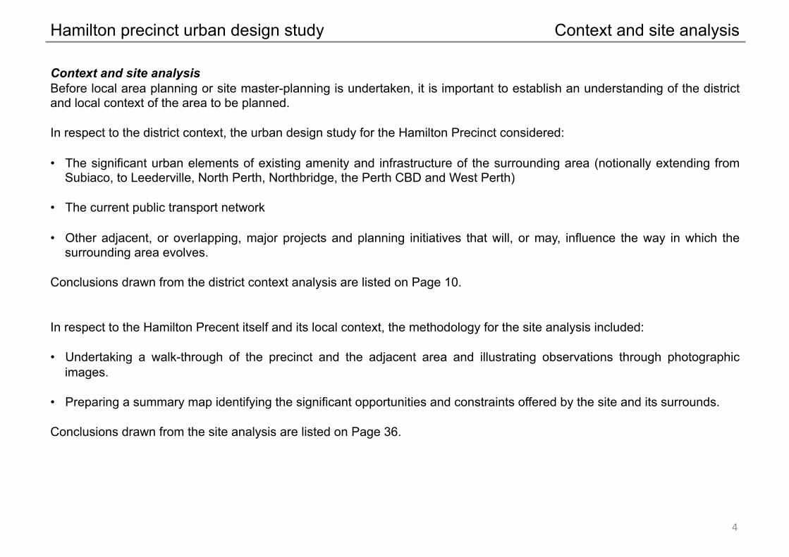
Context and site analysis Before local area planning or site master-planning is undertaken, it is important to establish an understanding of the district and local context of the area to be planned.
In respect to the district context, the urban design study for the Hamilton Precinct considered:
• The significant urban elements of existing amenity and infrastructure of the surrounding area (notionally extending from Subiaco, to Leederville, North Perth, Northbridge, the Perth CBD and West Perth)
• The current public transport network
• Other adjacent, or overlapping, major projects and planning initiatives that will, or may, influence the way in which the surrounding area evolves.
Conclusions drawn from the district context analysis are listed on Page 10.
In respect to the Hamilton Precent itself and its local context, the methodology for the site analysis included:
• Undertaking a walk-through of the precinct and the adjacent area and illustrating observations through photographic images.
• Preparing a summary map identifying the significant opportunities and constraints offered by the site and its surrounds.
Conclusions drawn from the site analysis are listed on Page 36.
%"
Context and site analysis
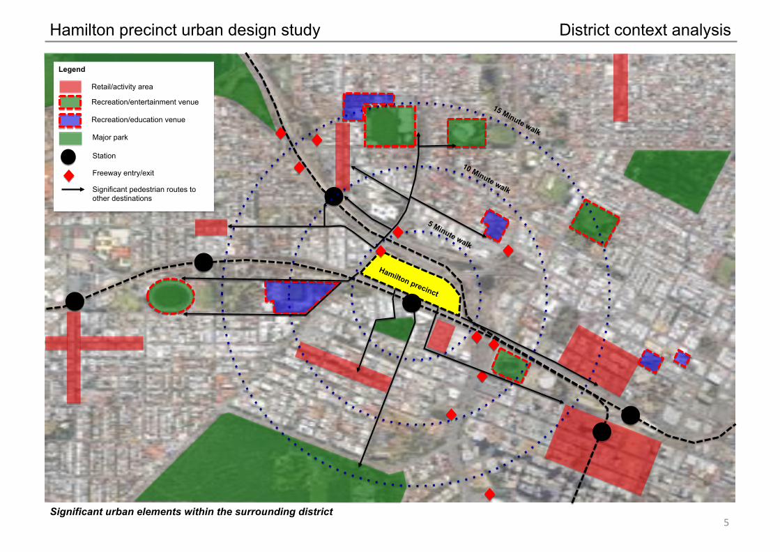
Hamilton precinct urban design study District context analysis
&"
Hamilton precinct
Legend
Significant urban elements within the surrounding district
Retail/activity area
Recreation/entertainment venue
Recreation/education venue
Major park
Station
Freeway entry/exit
Significant pedestrian routes to other destinations

Hamilton precinct urban design study District context analysis
Bus routes in the surrounding district '"

Hamilton precinct urban design study District context analysis
Other adjacent, or overlapping, major projects and planning studies ("
West Leederville planning and urban design study
Leederville master plan and built form guidelines study
WaterCorp master plan study
West Perth regeneration master plan
Hamilton precinct
Area considered by the City of Subiaco’s major stadium report
Area covered by the City of Perth Urban Design Framework
Northbridge Link project
Future PMH redevelopment

Hamilton precinct urban design study District context analysis
Other adjacent, or overlapping, major projects and planning studies )"
Leederville master plan and built form guidelines (including WaterCorp site)
• Significant increase in residential densities and allowable commercial floor space • Mixed use development encouraged • Retention and enhancement of the Oxford Street commercial area • Streetscape improvements • Mid-rise, with some high rise on podium development envisaged
City of Perth urban design framework
• Identifies a notional built form for the city • Identifies the Hamilton precinct as a potential TOD node • Provides a suite of objectives and guiding principles for appropriate urban design
responses to a city context

Hamilton precinct urban design study District context analysis
Other adjacent, or overlapping, major projects and planning studies *"
City of Subiaco planning report on the major stadium location
• Illustrates why Subiaco is the logical place for a new major stadium • Identifies the potential to see Subiaco and all of the above as the most
significant single urban regeneration project in Australia • Identifies the potential to sink the Fremantle railway between Subiaco and
West Perth station
West Leederville planning and urban design study
• Significant increase in residential densities and allowable commercial floor space • Mixed use development encouraged • New West Leederville town centre focused on Cambridge Street • Streetscape improvements • Mid-rise development envisaged
West Perth regeneration master plan
• Significant increase in residential densities and allowable commercial floor space • Mixed use development encouraged • Development of ‘main street’ commercial along Newcastle Street • Streetscape improvements • Two scenarios – one with mid-rise ‘European-scaled’ development, and one with high rise
on podium development • Suggestion of Cleaver Street railway station (not PTA endorsed).

Hamilton precinct urban design study
!+"
District context analysis conclusions
Conclusions of the district context analysis
• The precinct is within a 15-minute walk of 3 railway stations that together provide direct access to the entire metropolitan railway network.
• The precinct is within a 7.5-minute walk of two stations that provide direct access to all other stations on the Clarkson, Mandurah, Fremantle and Armadale railway lines.
• The precinct is within a short reach of multiple entry and exit points to the metropolitan freeway system.
• The precinct is within a 15-minute walk of the Perth CBD retail core, the Northridge entertainment precinct, and three local/district scale activity centres.
• The precinct is within a 15-minute walk of 5 significant sporting/entertainment facilities, 4 educational facilities and 2 parks of regional significance.
• Of the above, the access to the regional movement network and access to local/district activity provides a good context for commercial location, but, altogether, the above provides an even better context for residential location.
• The precinct is surrounded on three sides by future major redevelopment projects. As such, with an integrated approach to planning and implementation, the precinct could form the heart of one of the largest and most significant urban regeneration projects in the country.
• Whilst the precinct is within a 15-minute walk of other centres, it is sufficiently remote from the other centres to support its own retail and food and beverage outlets, subject to a sufficiently large resident and worker population.
• The most significant pedestrian connections to the precinct, which need reinforcing, are to the northwest (towards Leederville and Leederville station), and to the south and southwest (towards West Perth and the Perth central area).

Hamilton precinct urban design study
Site observations
Only so much information can be gleaned from looking at aerial photographs and reading reports. The best way to understand a place, it’s attractions and failings, is to walk around and observe …
Site observations
!!"
Troode Street
Plaistowe M
ews
Colin Place
Railway Street
Suth
erla
nd S
treet
Hamilton precinct urban design study
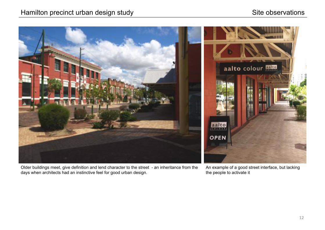
Older buildings meet, give definition and lend character to the street - an inheritance from the days when architects had an instinctive feel for good urban design.
An example of a good street interface, but lacking the people to activate it
Site observations
!#"

Hamilton precinct urban design study
The rest of West Perth is visible from Plaistowe Mews, but the environment offers no clear indication of how to get there.
The station infrastructure is minimal and needs to be upgraded if it is to be considered as the focus of a TOD
Site observations
!$"

Hamilton precinct urban design study
The rail is sufficiently elevated at Plaistowe Mews to warrant a pedestrian underpass to West Perth (but not high enough for a road underpass).
The Perth CBD is visible and there is a path leading there, but the environment is hostile and unattractive to pedestrians.
Site observations
!%"

Hamilton precinct urban design study
A loading dock interface with a street is an unacceptable urban design outcome.
There is a little sense from the station that Delhi Street goes anywhere – pedestrians need to be drawn sufficiently far along the street to see around the bend.
Site observations
!&"

Hamilton precinct urban design study
Even when buildings meet the street, the pedestrian amenity is limited because of the lack of shade and shelter.
Blank walls and an under-croft car park interface with a street are unacceptable urban design outcomes.
Site observations
!'"

Hamilton precinct urban design study
An at-grade car park interface with a street is an unacceptable urban design outcome.
Bushes planted against a footpath are not a good idea as they offer ambush opportunities on unsuspecting pedestrians.
Site observations
!("

Hamilton precinct urban design study
Car parking in the setback area is an unacceptable urban design outcome, regardless of whether it’s done like this …
…or this.
Site observations
!)"

Hamilton precinct urban design study
The rail at Campbell Street allows a simple at-grade pedestrian crossing and a sight line across to Boas Gardens.
The vacant corner site on Railway Street / Colin Place is a good design outcome waiting to happen.
Site observations
!*"
Hamilton precinct urban design study
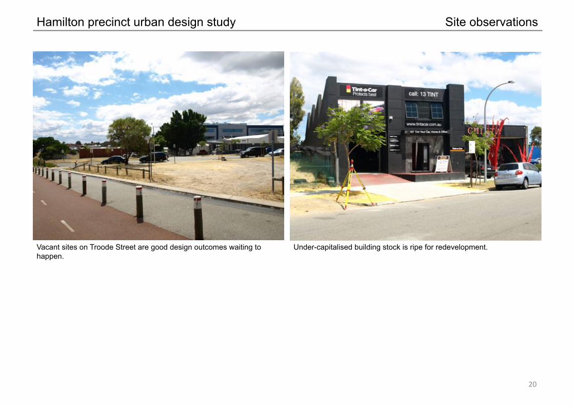
Vacant sites on Troode Street are good design outcomes waiting to happen.
Under-capitalised building stock is ripe for redevelopment.
Site observations
#+"

Hamilton precinct urban design study
It’s such a hostile road environment that the path has been located as far away as possible and trees planted to hide it.
Loftus Street – transformed over time because designing for cars has taken precedence over designing for people.
Site observations
#!"

Hamilton precinct urban design study
A small patch of vacant, fence-off land on an important street corner provides the first impression of the precinct on arrival from Loftus Street.
An intimidating pedestrian environment, that illustrates why underpasses are considered by urban designers as the very last resort for road crossings.
Site observations
##"

Hamilton precinct urban design study
More vacant land, and on a prime corner site with a pre-made hollow for basement parking.
Site observations
#$"

Hamilton precinct urban design study
A new building meets the street, but still lacks pedestrian amenity. Note the shade structures over all the windows apart from the ground floor ones where the shade is needed most.
The front door faces the car park around the side rather than facing the street.
Site observations
#%"

Hamilton precinct urban design study
Substantial street trees; the last remaining vestige of a good street. A redundant length of valuable road reserve has been left abandoned and unused.
Site observations
#&"
Hamilton precinct urban design study
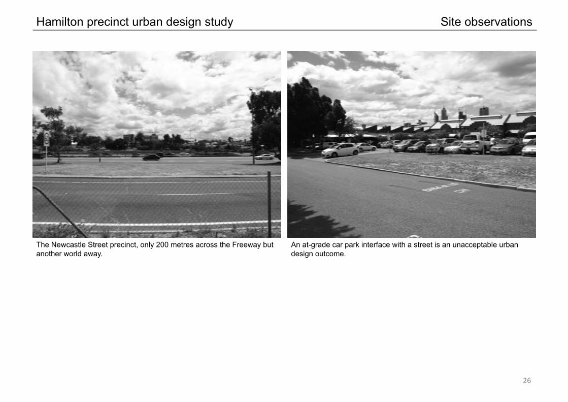
The Newcastle Street precinct, only 200 metres across the Freeway but another world away.
An at-grade car park interface with a street is an unacceptable urban design outcome.
Site observations
#'"

Hamilton precinct urban design study
Perhaps the most attractive and intimate spaces in the whole precinct, but, again, lacking the people to activate it.
Site observations
#("

Hamilton precinct urban design study
The closest thing in the precinct to a public space. A building separated from the street by large setbacks and a level change is an unacceptable urban design outcome.
Site observations
#)"

Hamilton precinct urban design study
Whilst the dome is a landmark, it lacks architectural significance and is a landmark only by virtue of the fact that it isn’t obscured by anything else.
An at-grade car park interface with a street is an unacceptable urban design outcome.
Site observations
#*"

Hamilton precinct urban design study
An opportunity for a landscape treatment to mitigate the visual hostility of a concrete wall.
An even bigger opportunity for a landscape treatment to mitigate the visual hostility of a Freeway interchange.
Site observations
$+"

Hamilton precinct urban design study
Another valuable but vacant corner site waiting to happen. A ready-made ‘gateway’ to the city, waiting for some special treatment to turn it from a utilitarian railway bridge into an arrival statement.
Site observations
$!"

Hamilton precinct urban design study
The route to Northbridge is a hostile environment that offers no attraction to pedestrians to go there.
Retail as a land use does not guarantee good street. Note, this is an important pedestrian link back to the city centre.
Site observations
$#"

Hamilton precinct urban design study
An important and under-capitalised site, even though it’s on the ‘wrong side of the tracks’ to the precinct.
The most important pedestrian connection from the precinct and station back to the rest of West Perth. Whist there is passive surveillance and lighting, there is little in the way of shade and shelter and the pathway is ‘utilitarian’.
Site observations
$$"
Hamilton precinct urban design study
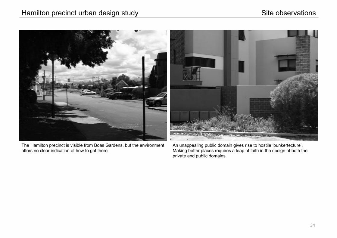
The Hamilton precinct is visible from Boas Gardens, but the environment offers no clear indication of how to get there.
An unappealing public domain gives rise to hostile ‘bunkertecture’. Making better places requires a leap of faith in the design of both the private and public domains.
Site observations
$%"

Hamilton precinct urban design study Site analysis mapping
$&"
Site analysis map
Major barrier – no crossings
Major barrier – some crossings
Vist
a to
par
k
Vista to park
Heritage/streetscape value
Streetscape value
Recent buildings
To H
arbo
urto
wn To Northbridge, Link and
entertainment centre
To West Perth
To West Perth
To West Leederville
,-./01"2-3-405"067896:"
;5<53=>-8:">6?=53"=6"3?>>6?:<-:."8>58"
@53=";5>=/">8-0A81"3=896:"
;>-B8>1"25/-705"5:=>1"=6"C>57-:7="
D576:<8>1"25/-705"5:=>1"=6"C>57-:7="
E?3">6?=53"

Hamilton precinct urban design study Site analysis conclusions
$'"
Conclusions of the site analysis
• The quality of the building stock is generally low, more suburban than urban in its form, non-existent, or is old enough to have paid for itself (except for two notable exceptions), and lends itself to redevelopment.
• Much of the existing building to street interface is poor – consisting of blank walls, service areas, and excessive setbacks filled with car parks.
• The quality of the public domain is poor, with very low levels of pedestrian amenity, which could be improved by intervention within the street reserves and at the building interface.
• The interface with Loftus Street is hostile to pedestrian movement and in need of improvement. • There is limited vehicle access to the precinct (and, thus, district permeability), with access available only from three
points along Railway Street (at Colin Place, Plaistowe Street, and Sutherland Street). • Key pedestrian linkages to West Perth (via Boas Gardens, Sutherland Street), and via Railway Street to Northbridge are
poor and in need of improvement. • Whilst the freeway, Loftus Street and railway lines are sources of noise, mitigation through built form (rather than
architectural detail) may compromise the delivery of a high quality public realm in the precinct’s streets. • The current aspect to the freeway is unattractive. • The change in level across the precinct offers good potential to incorporate undercroft parking and access without
excessive use of ramping. • The rising topography assists in equitable access to views to the city centre and across the inner suburbs from upper
levels. • The West Perth station is an asset, but offers a poor user experience and is in need of upgrading if it is to be considered
as an important urban station. • The remnant street trees in Troode Street are an asset worth retaining, as are some of the older ex-industrial building
frontages to the west of Plaistowe Mews. • The site has excellent visual exposure to passing traffic, but that does not necessarily translate into accessibility. • The street network in West Perth offers the opportunity for street vistas to and from the precinct to add value and aid
legibility.

Hamilton precinct urban design study A vision
$("
It’s important in any planning initiative to state up-front a vision of what is desired. For the Hamilton Precinct, the City of Perth offers the following vision:
In planning jargon: A vibrant and sustainable, residential-rich, mixed-use precinct that compliments the Perth CBD with a diversity of uses; has a high level of pedestrian amenity; provides a strong residential hinterland to the CBD; and has good access to the regional public transport network.
In plain English: A cool place in the middle of everywhere to live, work and hang out.
Currently, the area is a utilitarian and uninspiring fringe area of the city centre - a motley collection of former industrial buildings, vacant sites and a suburban shopping complex with a sea of car parking, all crammed in between a tangle of road and rail infrastructure.
The vision is for this area to be reinvented as a piece of real city; an oasis of urbanity, that provides a stepping stone between the city and the increasingly important hot-spots of Leederville, West Leederville, West Perth and Subiaco.
The vision is of a place where people live, play, and work; composed of recognisably urban buildings of a comfortable urban scale that define streets and other public spaces. The edges of the streets provide commercial opportunities to engage people as they walk through the precinct.
In short, the vision is for the type of place envisaged by the Perth Urban Design Framework.
To better understand how the vision may be achieved, the following developments, from around Australia and around the world have been identified as having attributes of the City’s vision.

Hamilton precinct urban design study Learning from other places
$)"
QV2, Melbourne
• Major CBD edge mixed-use development • Good balance of retail, entertainment, residential, and commercial • Incorporates large-format retailing (supermarket and discount department store) • Good street edges, with high-rise contemporary architecture • Incorporates a public piazza • Very popular Melbourne destination

Hamilton precinct urban design study Learning from other places
$*"
Rouse Hill, NSW
• Regional suburban activity centre presented as a town centre • Predominantly retail but with significant residential, entertainment, and other commercial uses • Incorporates large format retailing (supermarkets and discount department stores) • Combination of pedestrian-friendly streets and open and closed malls • Incorporates a public piazza • Considered to be Australia’s ‘state of the art’ suburban centre

Hamilton precinct urban design study Learning from other places
%+"
Claremont, WA
• Major mixed use development integrated into a regional town centre • Predominantly retail but with significant residential and other commercial uses • Incorporates large format retailing (supermarket, department store and mini-majors) • Combination of pedestrian-friendly street and closed malls • Incorporates a public piazza • Considered to be Western Australia’s ‘state of the art’ suburban centre

Hamilton precinct urban design study Learning from other places
%!"
The Grove, California
• Major retail development presented as town • Predominantly retail and entertainment • Poor interface with surrounding area, with the external face dominated by at-grade car-parking • Some significant residential and commercial development in the overall precinct but kept separate from the activity. • Incorporates a public piazza • Very popular LA destination and features on the to-do tourist list

Hamilton precinct urban design study Learning from other places
%#"
The Chancery, Auckland, NZ
• Major CBD edge mixed-use development • Predominantly retail and residential, with some commercial • Good street edges • Incorporates a high-rise residential tower, within a predominantly pedestrian scaled network of streets and spaces • Incorporates a mixture of open and enclosed mall spaces

Hamilton precinct urban design study Development framework plan and principles
%$"
Development framework plan A development framework plan (illustrated on page 44) has been developed to provide spatial guidance as to how redevelopment should occur within the Hamilton Precinct.
The development framework plan identifies a range of urban design considerations such as pedestrian routes, the locations of open spaces and vehicle access points, and the location of pedestrian building envelopes that are defined by height and relationship to the street. It should be noted that the building envelopes are not envisaged as the maximum extent of potential buildings but are simply envelopes that provide a reasonable degree of flexibility within which buildings are to be contained.
Development principles In addition to the Development Framework Plan, a suite of principles has been developed to provide more detailed guidance as to how redevelopment should occur within the Hamilton Precinct. The development principles are listed on pages 45-46.

Hamilton precinct urban design study Development framework plan
%%"
3 storey max/ 2 storey ,min urban wall 5 storey max/3 storey min urban wall 8 storey max overall height Tower opportunity Open space location Future ‘blue sky’ opportunity Potential ‘northern gateway’ park Main pedestrian routes Main cycle routes Retained heritage facades
0 100 200 300m
1 Upgraded station 2 Pedestrian underpass integrated with new station entrance 3 New pedestrian footbridge/land bridge 4 Central piazza space with visual link to the station 5 Urban park with active edges and a new narrow vehicular lane and E-W
pedestrian link 6 New street 7 Extension of Cambridge Street to Sutherland Street 8 Relocated Freeway exit to activate precinct and reduce pressure on
Loftus Street 9 Open space to improve sightlines into pedestrian underpass 10 Better management of pedestrian/cycle/traffic relationship on Loftus
Street 11 Possible future alignment of West Leederville railway tunnel 12 Future redevelopment of railway reserve (subject to tunnel) 13 Future ‘building bridges’ to create an urban connection to Leederville 14 People’s market wall connection back to Northbridge 15 Existing new ‘McMahon” building assumed to be retained
TO
TO
TO
TO
TO
TO
TO
TO
1
2
3
4 5
6
7
8
11
10
9
12
13
13
14
12 TO
15
Troode Street
Plaistowe M
ews
Colin Place
Railway Street
Suth
erla
nd S
treet
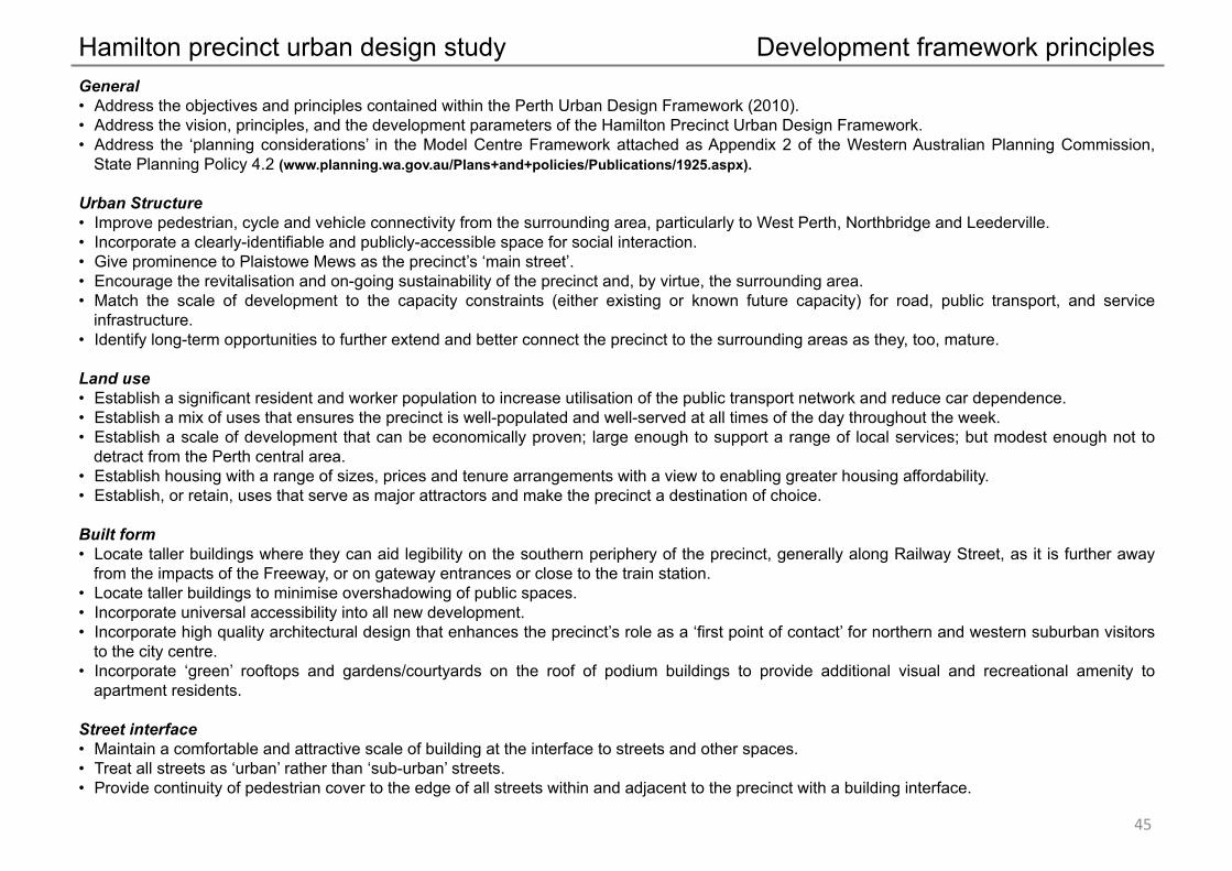
Hamilton precinct urban design study Development framework principles
%&"
General • Address the objectives and principles contained within the Perth Urban Design Framework (2010). • Address the vision, principles, and the development parameters of the Hamilton Precinct Urban Design Framework. • Address the ‘planning considerations’ in the Model Centre Framework attached as Appendix 2 of the Western Australian Planning Commission,
State Planning Policy 4.2 (www.planning.wa.gov.au/Plans+and+policies/Publications/1925.aspx).
Urban Structure • Improve pedestrian, cycle and vehicle connectivity from the surrounding area, particularly to West Perth, Northbridge and Leederville. • Incorporate a clearly-identifiable and publicly-accessible space for social interaction. • Give prominence to Plaistowe Mews as the precinct’s ‘main street’. • Encourage the revitalisation and on-going sustainability of the precinct and, by virtue, the surrounding area. • Match the scale of development to the capacity constraints (either existing or known future capacity) for road, public transport, and service
infrastructure. • Identify long-term opportunities to further extend and better connect the precinct to the surrounding areas as they, too, mature.
Land use • Establish a significant resident and worker population to increase utilisation of the public transport network and reduce car dependence. • Establish a mix of uses that ensures the precinct is well-populated and well-served at all times of the day throughout the week. • Establish a scale of development that can be economically proven; large enough to support a range of local services; but modest enough not to
detract from the Perth central area. • Establish housing with a range of sizes, prices and tenure arrangements with a view to enabling greater housing affordability. • Establish, or retain, uses that serve as major attractors and make the precinct a destination of choice.
Built form • Locate taller buildings where they can aid legibility on the southern periphery of the precinct, generally along Railway Street, as it is further away
from the impacts of the Freeway, or on gateway entrances or close to the train station. • Locate taller buildings to minimise overshadowing of public spaces. • Incorporate universal accessibility into all new development. • Incorporate high quality architectural design that enhances the precinct’s role as a ‘first point of contact’ for northern and western suburban visitors
to the city centre. • Incorporate ‘green’ rooftops and gardens/courtyards on the roof of podium buildings to provide additional visual and recreational amenity to
apartment residents.
Street interface • Maintain a comfortable and attractive scale of building at the interface to streets and other spaces. • Treat all streets as ‘urban’ rather than ‘sub-urban’ streets. • Provide continuity of pedestrian cover to the edge of all streets within and adjacent to the precinct with a building interface.

Hamilton precinct urban design study Development framework principles
%'"
• Avoid excessive areas of blank walls and provide opportunities for passive surveillance of all publicly-accessible areas. • Encourage pedestrian movement at street level (where possible) rather than via the use of bridges or underpasses, utilising controlled crossings at
major crossing points.
Vehicle access and parking • Locate car-parking areas under, behind, on, or within buildings, and screen from publically accessible areas. • Demonstrate the impact of development on the surrounding street network and identify any necessary improvements to maintain an acceptable
level of service. • Minimise the number of vehicle crossovers to service and parking areas.
Landscape • Retain existing mature street trees. • Establish a simple but high quality landscape treatment to all of the streets within and surrounding the precinct. • Establish street trees wherever possible. • Potential for a ‘northern gateway’ park to compliment the John Oldham Park to the south of the city. Hundreds of thousands of people pass through
it each day on car, train or bike.
Resilience • Incorporate best practice energy and water efficient design. • Design internal spaces with the flexibility to accommodate different uses over a building’s life.
Heritage • Retain the heritage listed buildings fronting the western edge of Plaistowe Mews.
It is envisaged that the above principles, in conjunction with the objectives and the principles of the City of Perth UDF and the planning considerations of the Model Centre Framework would inform any future planning controls for the area.

Hamilton precinct urban design study
Introduction to the built form scenarios and analysis Three scenarios were modelled and analysed to test the Development Framework Plan and the associated principles, and to help determine an appropriate scale of building for the Hamilton Precinct.
The scenarios identified three potential built forms ranging from a conservative three-storey approach to redevelopment (scenario 1), to a far more intense redevelopment strategy (scenario 2) that capitalised on WA’s growing economic good fortune. The third scenario was an in-between scenario that more closely matched the economic analysis and findings undertaken by the AEC Group.
For each scenario, a conceptual 3D massing model was developed, based on the attributes of the Development Framework Plan and the associated principles. Whilst not fully-resolved architectural solutions, the 3D models were sufficient to enable indicative floorspace figures to be derived from a built-form outcome rather than the traditional approach of deriving floorspace figures from plot ratio figures alone. It should be noted that the 3D models are not representations of the building envelopes described in the Development Framework Plan, but represent an indicative built form that may arise within those envelopes.
Each 3D scenario model was measured at each floor level and a gross-to-net percentage of 66% was applied to determine an indicative net floor area. The 66% figure represents a conservative gross-to-net ratio in the knowledge that, typically, gross-to-net ratios range from around 60% to 80% depending on the type, form, and scale of building. In addition, gross-to-net ratios are dependant dependant on constraints such as the need to achieve a reasonably regular structural grid and adequate depths of floor plates and, as such, the higher percentage, often seen as a target by developers, is often difficult to achieve in reality.
Indicative building floorspace figures were grouped together on a sub-area basis, with the plan on page 48 indicating the various sub areas. Based on the net floorspace of each scenario, a resulting indicative plot ratio for each sub-area could then be derived for the relevant built form.
%("
Built form scenarios and analysis
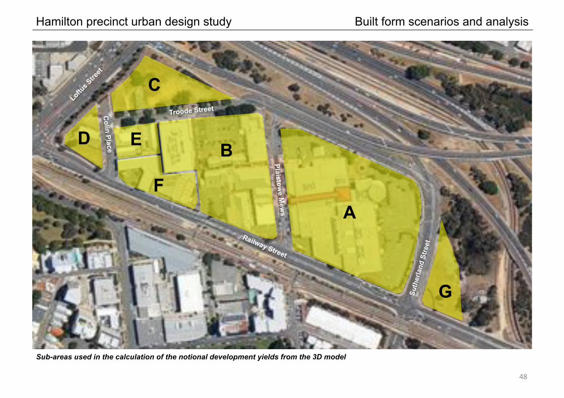
Hamilton precinct urban design study Built form scenarios and analysis
%)"
A
B
C
D E
F
G
Sub-areas used in the calculation of the notional development yields from the 3D model
Troode Street
Plaistowe M
ews
Colin Place
Railway Street
Suth
erla
nd S
treet

Hamilton precinct urban design study Built form scenario 1 – concept model
%*"
Scenario 1 (3-storey minimum development) viewed from the south west
Troo
de S
tree
t
Plaistowe Mews
Colin Place
Sutherland Street

Hamilton precinct urban design study Built form scenario 1 – concept model
&+"
Scenario 1 (3-storey minimum development) viewed from the north east
Plaistowe Mews
Colin Place
Sutherland Street
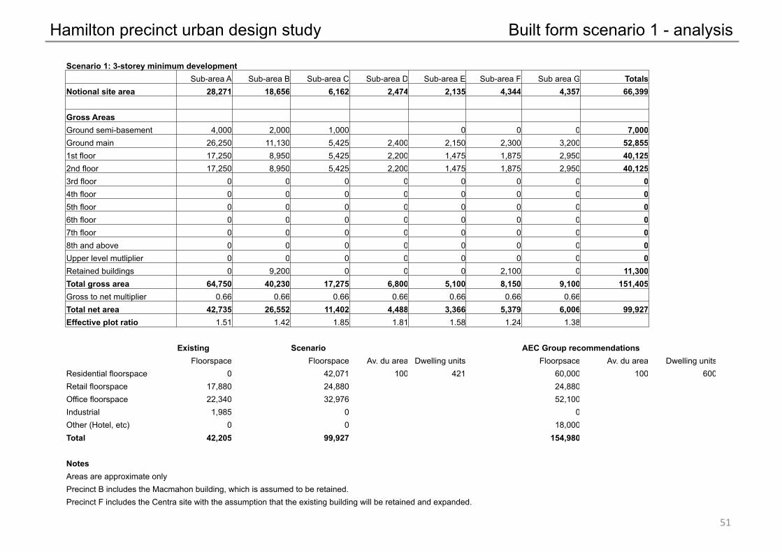
Hamilton precinct urban design study Built form scenario 1 - analysis
&!"
Scenario 1: 3-storey minimum development Sub-area A Sub-area B Sub-area C Sub-area D Sub-area E Sub-area F Sub area G Totals
Notional site area 28,271 18,656 6,162 2,474 2,135 4,344 4,357 66,399
Gross Areas Ground semi-basement 4,000 2,000 1,000 0 0 0 7,000 Ground main 26,250 11,130 5,425 2,400 2,150 2,300 3,200 52,855 1st floor 17,250 8,950 5,425 2,200 1,475 1,875 2,950 40,125 2nd floor 17,250 8,950 5,425 2,200 1,475 1,875 2,950 40,125 3rd floor 0 0 0 0 0 0 0 0 4th floor 0 0 0 0 0 0 0 0 5th floor 0 0 0 0 0 0 0 0 6th floor 0 0 0 0 0 0 0 0 7th floor 0 0 0 0 0 0 0 0 8th and above 0 0 0 0 0 0 0 0 Upper level mutliplier 0 0 0 0 0 0 0 0 Retained buildings 0 9,200 0 0 0 2,100 0 11,300 Total gross area 64,750 40,230 17,275 6,800 5,100 8,150 9,100 151,405 Gross to net multiplier 0.66 0.66 0.66 0.66 0.66 0.66 0.66 Total net area 42,735 26,552 11,402 4,488 3,366 5,379 6,006 99,927 Effective plot ratio 1.51 1.42 1.85 1.81 1.58 1.24 1.38
Existing Scenario AEC Group recommendations Floorspace Floorspace Av. du area Dwelling units Floorpsace Av. du area Dwelling units
Residential floorspace 0 42,071 100 421 60,000 100 600 Retail floorspace 17,880 24,880 24,880 Office floorspace 22,340 32,976 52,100 Industrial 1,985 0 0 Other (Hotel, etc) 0 0 18,000 Total 42,205 99,927 154,980
Notes Areas are approximate only Precinct B includes the Macmahon building, which is assumed to be retained. Precinct F includes the Centra site with the assumption that the existing building will be retained and expanded.

Hamilton precinct urban design study Built form scenario 2 – concept model
&#"
Scenario 2 (high development scenario) viewed from the south west
Troo
de S
tree
t
Plaistowe Mews
Colin Place
Sutherland St

Hamilton precinct urban design study Built form scenario 2 – concept model
&$"
Scenario 2 (high development scenario) viewed from the north east
Plaistowe Mews
Colin Place
Sutherland Street

Hamilton precinct urban design study Built form scenario 2 - analysis
&%"
Scenario 2: High development scenario Sub-area A Sub-area B Sub-area C Sub-area D Sub-area E Sub-area F Sub area G Totals
Notional site area 28,271 18,656 6,162 2,474 2,135 4,344 4,357 66,399
Gross Areas Ground semi-basement 4,000 2,000 1,000 0 0 0 0 7,000 Ground main 26,250 11,225 5,425 2,400 2,150 3,500 3,800 54,750 1st floor 23,500 10,300 5,425 2,400 1,725 3,500 3,500 50,350 2nd floor 14,475 10,300 5,425 2,400 1,725 3,500 3,500 41,325 3rd floor 11,350 4,600 4,450 2,100 1,200 2,500 3,250 29,450 4th floor 11,350 4,600 4,450 2,100 1,200 2,500 2,775 28,975 5th floor 5,000 2,550 1,275 975 1,200 1,600 1,125 13,725 6th floor 5,000 2,550 1,275 975 1,200 1,600 1,125 13,725 7th floor 3,275 1,525 1,275 975 1,200 1,600 1,125 10,975 8th and above 26,200 6,100 10,200 3,900 1,200 6,400 4,500 58,500 Upper level mutliplier 8 4 8 4 1 4 4 Retained buildings 0 9,200 0 0 0 0 0 9,200 Total gross area 130,400 55,750 40,200 18,225 12,800 26,700 24,700 308,775 Gross to net multiplier 0.66 0.66 0.66 0.66 0.66 0.66 0.66 Total net area 86,064 36,795 26,532 12,029 8,448 17,622 16,302 203,792 Effective plot ratio 3.04 1.97 4.31 4.86 3.96 4.06 3.74
Existing Scenario AEC Group recommendations Floorspace Floorspace Av. du area Dwelling units Floorpsace Av. du area Dwelling units
Residential floorspace 0 93,660 100 937 60,000 100 600 Retail floorspace 17,880 24,880 24,880 Office floorspace 22,340 67,251 52,100 Industrial 1,985 0 0 Other (Hotel, etc) 0 18,000 18,000 Total 42,205 203,792 154,980
Notes Areas are approximate only Precinct B includes the Macmahon building, which is assumed to be retained. Precinct F includes the Centra site with the assumption that the existing building will ultimately be redeveloped.

Hamilton precinct urban design study Built form scenario 3 – concept model
&&"
Scenario 3 (medium development scenario) viewed from the south west
Troo
de S
tree
t
Plaistowe Mews
Colin Place
Sutherland St

Hamilton precinct urban design study Built form scenario 3 – concept model
&'"
Scenario 3 (medium development scenario) viewed from the north east
Plaistowe Mews
Colin Place
Sutherland Street

Hamilton precinct urban design study Built form scenario 3 - analysis
&("
Scenario 3: Moderate development scenario Sub-area A Sub-area B Sub-area C Sub-area D Sub-area E Sub-area F Sub area G Totals
Notional site area 28,271 18,656 6,162 2,474 2,135 4,344 4,357 66,399
Gross Areas Ground semi-basement 4,000 2,000 1,000 0 0 0 0 7,000 Ground main 26,250 11,225 5,425 2,400 2,150 3,700 3,800 54,950 1st floor 14,475 10,300 5,425 2,400 1,725 3,700 3,500 41,525 2nd floor 14,475 10,300 5,425 2,400 1,725 3,700 3,500 41,525 3rd floor 6,775 4,600 3,775 1,825 1,200 3,325 3,250 24,750 4th floor 6,775 4,600 3,775 1,825 1,200 3,325 2,775 24,275 5th floor 3,275 2,550 1,275 0 0 0 1,125 8,225 6th floor 3,275 2,550 1,275 0 0 0 0 7,100 7th floor 3,275 1,525 1,275 0 0 0 0 6,075 8th and above 19,650 6,100 - - - - - 25,750 Upper level mutliplier 6 4 0 0 0 0 0 Retained buildings 0 9,200 0 0 0 0 0 9,200 Total gross area 102,225 55,750 28,650 10,850 8,000 17,750 17,950 241,175 Gross to net multiplier 0.66 0.66 0.66 0.66 0.66 0.66 0.66 Total net area 67,469 36,795 18,909 7,161 5,280 11,715 11,847 159,176 Effective plot ratio 2.39 1.97 3.07 2.89 2.47 2.70 2.72
Existing Scenario AEC Group recommendations Floorspace Floorspace Av. du area Dwelling units Floorpsace Av. du area Dwelling units
Residential floorspace 0 63,768 100 638 60,000 100 600 Retail floorspace 17,880 24,880 24,880 Office floorspace 22,340 52,528 52,100 Industrial 1,985 0 0 Other (Hotel, etc) 0 18,000 18,000 Total 42,205 159,176 154,980
Notes Areas are approximate only Precinct B includes the Macmahon building, which is assumed to be retained. Precinct F includes the Centra site with the assumption that the existing building will ultimately be redeveloped.

Hamilton precinct urban design study
Recommendation and Rationale Based on a consideration of the three scenarios, and a range of broader citywide issues, the recommendation of this study is for the City of Perth to encourage redevelopment within the Hamilton Precinct based on Scenario 2; the most ambitious of the three scenarios.
The 3D modelling for Scenario 2 suggested that the built form derived form the Urban Design Framework and associated principles could reasonably deliver development with a plot ratio that is typically in the range of 3.0 to 4.0:1, given the need to respond to constraints such as the need to achieve a reasonably regular structural grid and adequate depths of floor plates.
In the case of the precinct's core (sub-areas A and B), it is recommended that the maximum plot ratio be raised where there is provision of specific public facilities to the satisfaction of the City of Perth. In all cases, an appropriate minimum plot ratio should apply to residential use, and an appropriate maximum plot ratio should apply to non-residential uses. This split approach to plot ratio is consistent with the City’s approach in West Perth, and is intended to provide an incentive to include residential development and avoid the precinct developing into a monoculture of nine-to-five commercial uses.
The recommendation to pursue Scenario 2 is based on the following rationale:
• The Hamilton Precinct is strategically located between two railway stations (West Perth and Leederville) and, as such, is an ideal location for relatively intense Transit-Orientated Development, as identified in the City’s Urban Design Framework (An Urban Design Framework – A Vision for Perth 2029).
• Whilst the AEC Group economic analysis recommended residential and non-residential floorspace targets for the precinct, there is no guarantee that all of the land will be redeveloped in the short-to-medium term, so the overall development capacity of the precinct needs to be high enough to factor in the undeveloped sites if the AEC Group‘s target floorspace is to be achieved.
• The resultant built form derived form the Urban Design Framework and associated principles is appropriate to the precinct’s relationship to the CBD area and West Perth.
• Through the consultation process, there was widespread support from landowners in the precinct for the more ambitious scenario.
• The taller built form provides a strong visual cue in the broader city landscape that the Hamilton Precinct is a strategic TOD location.
Finally, it is recommended that the City amend its planning scheme, CPS2, to incorporate development controls consistent with the Urban Design Framework Plan.
&)"
RECOMMENDATION AND RATIONALE
Hamilton precinct urban design study
Statutory documents • Metropolitan Region Scheme: WAPC • City of Perth City Planning Scheme No. 2: City of Perth
Policies and reports • An Urban Design Framework – A Vision for Perth 2029: City of Perth; 2010 • Plot Ratio and Built Form Study (Part A): City of Perth/The Planning Group; 2010 • Capital City Planning Framework: WAPC; 2011 • Directions 2031 and Beyond; WAPC; 2010 • Leederville Master Plan and Built Form Guidelines: Town of Vincent; 2009 (rev 2010) • West Perth Regeneration Master Plan: Town of Vincent; 2008 • West Leederville Planning and Urban Design Study: Town of Cambridge; 2010 • Subiaco – The Home of Football in WA; City of Subiaco; 2010 • Hamilton Precinct Economic Analysis: AEC Group; 2010 • Hamilton Master Plan Report: GRA; 2009
&*"
REFERENCES