Embed Size (px)
Citation preview
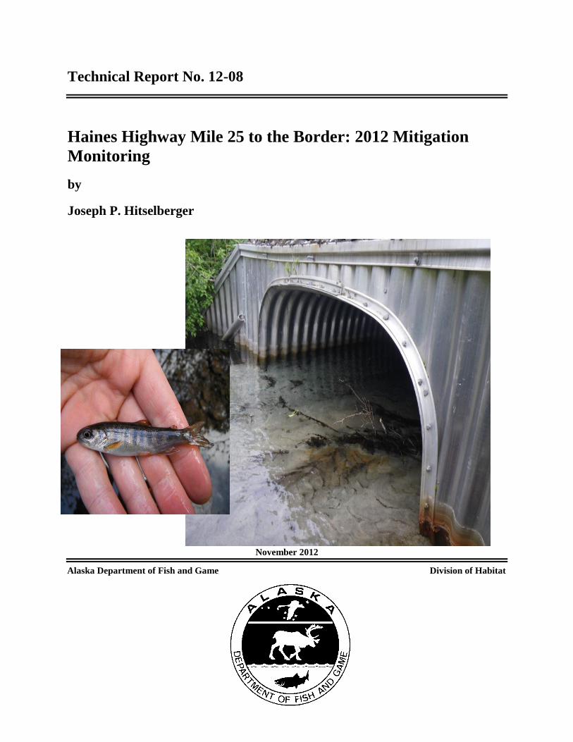
Technical Report No. 12-08
Haines Highway Mile 25 to the Border: 2012 Mitigation
Monitoring
by
Joseph P. Hitselberger
November 2012
Alaska Department of Fish and Game Division of Habitat
Symbols and Abbreviations
The following symbols and abbreviations, and others approved for the Système International d'Unités (SI), are used
without definition in the following reports by the Divisions of Sport Fish and of Commercial Fisheries: Fishery
Manuscripts, Fishery Data Series Reports, Fishery Management Reports, and Special Publications. All others,
including deviations from definitions listed below, are noted in the text at first mention, as well as in the titles or
footnotes of tables, and in figure or figure captions.
Weights and measures (metric)
centimeter cm
deciliter dL
gram g
hectare ha
kilogram kg
kilometer km
liter L
meter m
milliliter mL
millimeter mm
Weights and measures (English)
cubic feet per second ft3/s
foot ft
gallon gal
inch in
mile mi
nautical mile nmi
ounce oz
pound lb
quart qt
yard yd
Time and temperature
day d
degrees Celsius °C
degrees Fahrenheit °F
degrees kelvin K
hour h
minute min
second s
Physics and chemistry
all atomic symbols
alternating current AC
ampere A
calorie cal
direct current DC
hertz Hz
horsepower hp
hydrogen ion activity pH
(negative log of)
parts per million ppm
parts per thousand ppt,
‰
volts V
watts W
General
Alaska Administrative
Code AAC
all commonly accepted
abbreviations e.g., Mr., Mrs., AM, PM, etc.
all commonly accepted
professional titles e.g., Dr., Ph.D.,
R.N., etc.
at @
compass directions:
east E
north N
south S
west W
copyright
corporate suffixes:
Company Co.
Corporation Corp.
Incorporated Inc.
Limited Ltd.
District of Columbia D.C.
et alii (and others) et al.
et cetera (and so forth) etc.
exempli gratia
(for example) e.g.
Federal Information
Code FIC
id est (that is) i.e.
latitude or longitude lat. or long.
monetary symbols
(U.S.) $, ¢
months (tables and
figures): first three
letters Jan,...,Dec
registered trademark
trademark
United States
(adjective) U.S.
United States of
America (noun) USA
U.S.C. United States Code
U.S. state use two-letter abbreviations (e.g., AK, WA)
Mathematics, statistics
all standard mathematical
signs, symbols and
abbreviations
alternate hypothesis HA
base of natural logarithm e
catch per unit effort CPUE
coefficient of variation CV
common test statistics (F, t, 2, etc.)
confidence interval CI
correlation coefficient
(multiple) R
correlation coefficient
(simple) r
covariance cov
degree (angular ) °
degrees of freedom df
expected value E
greater than >
greater than or equal to
harvest per unit effort HPUE
less than <
less than or equal to
logarithm (natural) ln
logarithm (base 10) log
logarithm (specify base) log2, etc.
minute (angular) '
not significant NS
null hypothesis HO
percent %
probability P
probability of a type I error
(rejection of the null
hypothesis when true)
probability of a type II error
(acceptance of the null
hypothesis when false)
second (angular) "
standard deviation SD
standard error SE
variance
population Var
sample var

TECHNICAL REPORT NO. 12-08
HAINES HIGHWAY MILE 25 TO THE BORDER: 2012 MITIGATION
MONITORING
By
Joseph P. Hitselberger
Alaska Department of Fish and Game,
Division of Habitat
Douglas, Alaska
This investigation was funded by the Alaska Department of Transportation and Public Facilities.
Alaska Department of Fish and Game
Division of Habitat, Southeast Region
802 W. 3rd
Street, Douglas, Alaska, 99824-0024
November 2012
Cover Photos: (1) Culvert CV-12 outlet. (2) Coho salmon (Oncorhynchus kisutch) captured from
stream channel CH-18. Copyright Alaska Department of Fish and Game. Photos by Joseph
Hitselberger.
Technical Reports are available through the Alaska State Library, Alaska Resources Library and
Information Services (ARLIS) and on the Internet:
http://www.adfg.alaska.gov/index.cfm?adfg=habitat_publications.main. This publication has
undergone editorial and peer review.
Note: Product names used in this publication are included for completeness but do not constitute product
endorsement. The Alaska Department of Fish and Game does not endorse or recommend any specific company or
their products.
Joseph P. Hitselberger,
Alaska Department of Fish and Game, Division of Habitat,
802 W. 3rd
Street, Douglas, Alaska, 99824-0024, USA
This document should be cited as:
Hitselberger, J.P. 2012. Haines Highway Mile 25 to the border: 2012 mitigation monitoring. Alaska Department of
Fish and Game, Technical Report No.12-08, Douglas, Alaska.
The Alaska Department of Fish and Game (ADF&G) administers all programs and activities free from discrimination
based on race, color, national origin, age, sex, religion, marital status, pregnancy, parenthood, or disability. The
department administers all programs and activities in compliance with Title VI of the Civil Rights Act of 1964, Section
504 of the Rehabilitation Act of 1973, Title II of the Americans with Disabilities Act (ADA) of 1990, the Age
Discrimination Act of 1975, and Title IX of the Education Amendments of 1972.
If you believe you have been discriminated against in any program, activity, or facility please write:
ADF&G ADA Coordinator, P.O. Box 115526, Juneau, AK 99811-5526
U.S. Fish and Wildlife Service, 4401 N. Fairfax Drive, MS 2042, Arlington, VA 22203
Office of Equal Opportunity, U.S. Department of the Interior, 1849 C Street NW MS 5230, Washington DC 20240
The department’s ADA Coordinator can be reached via phone at the following numbers:
(VOICE) 907-465-6077, (Statewide Telecommunication Device for the Deaf) 1-800-478-3648,
(Juneau TDD) 907-465-3646, or (FAX) 907-465-6078
For information on alternative formats and questions on this publication, please contact:
ADF&G Division of Sport Fish, Research and Technical Services, 333 Raspberry Road, Anchorage AK 99518 (907) 267-2375
i
TABLE OF CONTENTS Page
LIST OF TABLES......................................................................................................................................................... ii
LIST OF FIGURES ....................................................................................................................................................... ii
ACKNOWLEDGEMENTS ........................................................................................................................................... 1
EXECUTIVE SUMMARY ........................................................................................................................................... 2
INTRODUCTION ......................................................................................................................................................... 3
Purpose .......................................................................................................................................................................... 3
Location ......................................................................................................................................................................... 3
Methods ......................................................................................................................................................................... 3
MITIGATION SITES .................................................................................................................................................... 4
Project Permit Summary ................................................................................................................................................ 6
Stream Channels ............................................................................................................................................................ 7
Culverts.......................................................................................................................................................................... 9
CONCLUSION ........................................................................................................................................................... 18
REFERENCES CITED ............................................................................................................................................... 19
ii
LIST OF TABLES
Table Page
1. Mitigation Sites Monitored in this study. ........................................................................................................ 4 2. Anadromous Fish Block, 11 AAC 95.265(g) Table A. ................................................................................. 13
LIST OF FIGURES
Figure Page 1. Location of mitigation sites. ............................................................................................................................ 5 2. Lower section of CH-16 10/10/2011. .............................................................................................................. 8 3. Lower section of CH-16 5/10/2012. ................................................................................................................ 8 4. Stream Channel CH-18 10/10/11. ................................................................................................................... 9 5. Stream Channel CH-18 5/10/12. ..................................................................................................................... 9 6. Culvert CV-9 inlet 5/10/12. ........................................................................................................................... 10 7. Culvert CV-9 outlet 5/10/12. ......................................................................................................................... 10 8. Coho salmon captured above CV-10. ............................................................................................................ 11 9. CV-9 inlet 5/10/12. ........................................................................................................................................ 12 10. Pond below CV-11 8/5/12. ............................................................................................................................ 12 11. Beaver dam downstream of culvert CV-11 and CV-12. ................................................................................ 14 12. CV-12 outlet 6/13/12. .................................................................................................................................... 15 13. Upstream of CV-12 6/13/12. ......................................................................................................................... 15 14. Location of beaver dam, and Culvert CV-11 and CV-12. ............................................................................. 16 15. Culvert CV-13 outlet with baffles. ................................................................................................................ 17
1
ACKNOWLEDGEMENTS
I would like to thank the Alaska Department of Transportation and Public Facilities
(ADOT&PF) for funding this project. ADOT&PF staff Carolyn Morehouse, Janet Schempf and
Jane Gendron provided background information. ADF&G Habitat Southeast Regional
Supervisor Jackie Timothy collaborated on study design and edited the technical report. Habitat
Biologists Matt Kern, Gordon Willson-Naranjo, Ben Brewster, and College Intern Rick Hoffman
assisted with fieldwork. Amy Carroll prepared the technical report for publication. Eric
Prestegard and Rich Focht of Douglas Island Pink and Chum Inc. provided salmon eggs.
2
EXECUTIVE SUMMARY
The Alaska Department of Transportation and Public Facilities (ADOT&PF) reconstructed
portions of the Haines Highway between Mileposts 25 and 40 (the U.S./Canada border) to
improve public safety. Within the project area, the Klehini River and its tributaries support a
number of salmonid species, including: Chinook (Oncorhynchus tshawytscha), chum (O. keta),
pink (O. gorbuscha) and coho (O. kisutch) salmon; Dolly Varden char (Salvelinus malma); and
cutthroat trout (O. clarkia; Johnson and Blanche 2011).
ADOT&PF created 22.6 acres of wetlands, 3945 lineal feet of relocated stream, and 10,000
lineal feet of new stream to mitigate the impacts of the reconstruction project on fish and wildlife
resources and habitats. The highway reconstruction and mitigation projects were completed in
2001. The Alaska Department of Fish and Game (ADF&G) completed a 10-year monitoring
evaluation in 2011 (Hitselberger and Kern 2011) to determine if ADOT&PF had achieved their
mitigation objectives. Most wetlands, stream channels and culverts were built to specification
and were stable, achieving the mitigation objectives that were outlined in the original mitigation
plan (Inter-Fluve Inc. 2000).
In 2012, ADF&G resurveyed the sites where compliance with the mitigation objectives was
unknown; stream channels CH-16 and CH-18, and culverts CV-9, CV-10, CV-11, CV-12 and
CV-13. The 2012 survey documents these mitigation sites all meet or exceed the mitigation
objectives. Anadromous fish presence is not documented above culverts CV-11 or CV-12, but
there is no evidence this is due to culvert design or installation. Instead, natural barriers
downstream of the two culverts restrict upstream passage and anadromous fish have not been
documented beyond the barrier for the last three years.
Key words: Haines Highway, mitigation monitoring, mitigation objectives, stream relocation,
highway reconstruction, wetlands, stream channels, culvert, natural barrier, stream channels

3
INTRODUCTION
ADOT&PF committed to monitoring the mitigation sites described in the Executive Summary
for the reconstructed portions of the Haines Highway between Mileposts 25 and 40 for up to 10
years after construction, beginning in 2000. An analysis of the data will allow ADOT&PF to
determine if the mitigation objectives outlined in the original mitigation plan (Inter-Fluve Inc.
2000) are met, and to document the long-term effectiveness of the mitigation techniques for use
in future mitigation designs.
The ADF&G Division of Habitat agreed to conduct the fieldwork for the mitigation monitoring.
The 2011 monitoring report (Hitselberger and Kern 2011) identifies seven mitigation sites that
required additional monitoring in 2012. This report provides monitoring information for those
seven mitigation sites.
PURPOSE
Determine if the mitigation objectives for the Haines Highway reconstruction are met. Document
the long-term effectiveness of the mitigation program for use in future mitigation design.
LOCATION
Mitigation sites are located between milepost 25 and the U.S./Canada border at milepost 40
along the Haines Highway, near Haines, Alaska (Figure 1).
METHODS
The major indicator of project success is salmonid use of all 7 mitigation sites. We conducted
fieldwork in May, June, and August, when rising water levels allow juvenile salmonid access to
the mitigation sites. We trapped juvenile salmonids using the methods described in Magnus et al.
(2006) using two-piece galvanized steel minnow traps (42×23 cm, 22 mm openings, 6.4 mm
mesh; Aquatic Eco-Systems; Apopka, FL) baited with cured salmon eggs contained in a
punctured or opened plastic bag (118 ml Whirl-Pak; Nasco, Fort Atkinson, WI). We also used a
LR-24 Electrofisher (Smith-Root; Vancouver, Wa) to immobilize and capture juvenile fish. We
identified juveniles according to Pollard et al. (2006) and then released them back into the water
body from which they were captured. Fish captured by electrofishing were allowed to recover
before being released back in to the water body.

4
MITIGATION SITES
Table 1–Mitigation Sites Monitored in this study.
Site ID Type Year Completed Year Monitored
WT-5 Wetland 2000 & 2001 2004, 2005, 2006, 2011
WT-6 Wetland 2001 2004, 2005, 2006, 2011
CH-12 Stream Channel 2000 2004, 2005, 2006, 2011
CH-13 Stream Channel 2000 2004, 2005, 2006, 2011
CH-14 Stream Channel 2001 2004, 2005, 2006, 2011
CH-15 Stream Channel 2000 2004, 2005, 2006, 2011
CH-16 Stream Channel 2001 2004, 2005, 2006, 2011, 2012
CH-17 Stream Channel 2001 2004, 2005, 2006, 2011
CH-18 Stream Channel 2000 2004, 2005, 2006, 2011, 2012
CV-6 Culvert 2000 2004, 2005, 2006, 2011
CV-7 Culvert 2006 2004, 2005, 2006, 2011
CV-8 Culvert 2000 2004, 2005, 2006, 2011
CV-9 Culvert 2000 2004, 2005, 2006, 2011, 2012
CV-10 Culvert 2000 & 2001 2004, 2005, 2006, 2011, 2012
CV-11 Culvert 2000 & 2001 2004, 2005, 2006, 2011, 2012
CV-12 Culvert 2000 2004, 2005, 2006, 2011, 2012
CV-13 Culvert 2000 2004, 2005, 2006, 2011, 2012

5
Figure 1.– Location of mitigation sites.

6
PROJECT PERMIT SUMMARY
US Army Corps of Engineers
Permit No. 2-920515 10/1995 (modified 6/10/98, 6/11/99 and 7/7/00)
Authorization D-920515 for Nationwide Permit 3- slope repair 6/21/00
Permit No. 2-920515 10/26/99 (modified 1/26/00)
Alaska Department of Environmental Conservation
Certificate of Reasonable Assurance 10/23/95
Approval to Open Burn 11/2/98
NPDES Storm Water General Permit # AKRI OA 704
Letter of No Objection- Storm Water Management Plan No. 2021-WW-266-017 10/11/99
Alaska Department of Fish and Game
Fish Habitat Permit FG-98-I(J)-35 4/20/98
Fish Habitat Permit FG-98-I(J)-36 4/20/98 (amended 6/7/99, 9/21/99 and 7/7/00)
Fish Habitat Permit FG-98-I(J)-52 6/26/98 (amended 11/18/98, 9/21/99 and 5/5/00)
Fish Habitat Permit FG-99-I(J)-13 4/16/99
Fish Habitat Permit FG-99-I(J)-54 10/25/99 (amended 11/15/99, 1/11/00 and 1/12/00)
Fish Habitat Permit FG-99-I(J)-55 10/25/99 (amended 11/15/99, 2/15/00 and 3/13/00)
Fish Habitat Permit FG-99-I(J)-56 10/25/99 (amended 11/15/99)
Fish Habitat Permit FG-99-I(J)-57 10/25/99 (amended 11/15/99)
Fish Habitat Permit FG-00-I(J)-03 1/5/00 (amended 1/7/00 and 1/28/00)
Fish Habitat Permit FG-00-I(J)-08 3/13/00
Fish Habitat Permit FG-01-I(J)-20 5/25/01
Alaska Department of Natural Resources
Park Use Permit SEP 95-5-7
Temporary Water Use Permit #SE95-16
Temporary Water Use Permit #TWUP-J99-10 10/6/99
Material Sale contract ADL#106605 9/30/99
Final Consistency Determination ID No. AK9505-06JJ 10/2/95
Final Consistency Determination 9/30/99
7
STREAM CHANNELS
Mitigation Site CH-16
Location: 59.4392, -136.2663
Date Surveyed: 5/10/12
Description
A 24 in diameter culvert was removed from the abandoned highway. Spring Pond Creek (Stream
No. 115-32-10250-2077-3136-4002) originally flowed through the culvert from an uphill pond to
a smaller pond near the old highway embankment. Spring Pond Creek is cataloged for coho
salmon and cutthroat trout rearing. Originally, flows from the lower pond discharged into 37
Mile Creek (Stream No. 115-32-10250-2077-3136) as undefined seeps through the streambank,
and fish passage was undocumented. Stream channel CH-16 is two sections; one upstream
section connecting the two ponds, and one downstream section conveying flow into 37 Mile
Creek.
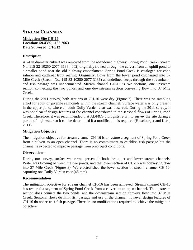
During the 2011 survey, both sections of CH-16 were dry (Figure 2). There was no sampling
effort for adult or juvenile salmonids within the stream channel. Surface water was only present
in the upper pond, where an adult Dolly Varden char was observed. During the 2011 survey, it
was not clear if design features of the channel contributed to the seasonal flows of Spring Pond
Creek. Therefore, it was recommended that ADF&G biologists return to survey the site during a
period of high water so it can be determined if a modification is required (Hitselberger and Kern,
2011).
Mitigation Objective
The mitigation objective for stream channel CH-16 is to restore a segment of Spring Pond Creek
from a culvert to an open channel. There is no commitment to establish fish passage but the
channel is expected to improve passage from preproject conditions.
Observations
During our survey, surface water was present in both the upper and lower stream channels.
Water was flowing between the two ponds, and the lower section of CH-16 was conveying flow
into 37 Mile Creek (Figure 3). We electrofished the lower section of stream channel CH-16,
capturing one Dolly Varden char (45 mm).
Recommendation
The mitigation objective for stream channel CH-16 has been achieved. Stream channel CH-16
has restored a segment of Spring Pond Creek from a culvert to an open channel. The upstream
section does connect the two ponds, and the downstream section conveys flow into 37 Mile
Creek. Seasonal flows do limit fish passage and use of the channel, however design features of
CH-16 do not restrict fish passage. There are no modifications required to achieve the mitigation
objective.

8
Figure 2.–Lower section of CH-16 10/10/2011. Figure 3.–Lower section of CH-16 5/10/2012.
Mitigation Site CH-18
Location: 59.4404, -136.2923
Date Surveyed: 5/10/12, 6/13/12, 6/14/12
Description
Stream channel CH-18 is a 150 ft long channel that was created to replace a section of 37½ Mile
Creek (Stream No. 115-32-10250-2077-3136-4018) that was filled in to construct the new
highway embankment. The channel is directly upstream of culvert CV-10, and drains 37½ Mile
Pond (Stream No. 115-32-10250-2077-3136-4018-0010).
During the 2011 survey the water level in CH-18 was very low (Figure 4), and salmonids were
not observed or captured in the stream channel. It was recommended that habitat biologists
return to survey the channel when water levels are expected to be higher and a more thorough
fish survey can be done (Hitselberger and Kern 2011).
Mitigation Objective
The mitigation objective for stream channel CH-18 is to replace the habitat covered by fill.
Observations
The water level in stream channel CH-18 was higher during our 5/10/12 survey (Figure 5). We
electrofished the stream channel and 37½ Mile Pond, however no fish were observed or captured
while electrofishing. Baited minnow traps were placed in the upper section of stream channel
CH-18 on 6/13/12, and were set for 24 hours. Four juvenile coho salmon (40–60 mm) were
captured when the traps were retrieved on 6/14/12.
9
Recommendation
Stream channel CH-18 does provide anadromous fish habitat and passage from culvert CV-10 to
37 ½ Mile Pond. Based on our observations, the mitigation objective for stream channel CH-18
has been achieved. Without knowing what type of habitat was covered by fill during the
reconstruction project, there are no modifications recommended for stream channel CH-18.
Figure 4.–Stream Channel CH-18 10/10/11. Figure 5.–Stream Channel CH-18 5/10/12.
CULVERTS
Mitigation Site CV-9
Location: 59.4392, -136.2819
Dates Surveyed: 5/10/12
Description
Culvert CV-9 is a 126 ft long, 14 ft 3 in × 9 ft 7 in aluminum structural plate pipe arch culvert.
The culvert is located on 37 Mile Creek, connecting stream channels CH-14 and CH-15.
Approximately 1.5 ft of class I riprap topped with 0.5 ft of gravel was placed in the culvert. A
bypass channel located near the inlet to CV-9 (stream channel CH-15) limits flood flows through
the culvert.
Observations from the 2011 survey indicate that water velocity appears to slightly increase
through the culvert, but there is no evidence of streambed scouring within the culvert. The
increased water velocity through culvert CV-9 may create a juvenile fish passage barrier. The
2011 report recommended that culvert CV-9 be surveyed again during higher water (Hitselberger
and Kern 2011).
10
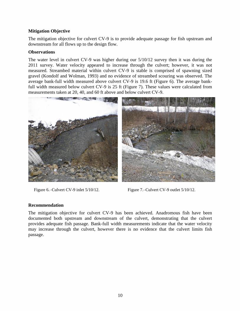
Mitigation Objective
The mitigation objective for culvert CV-9 is to provide adequate passage for fish upstream and
downstream for all flows up to the design flow.
Observations
The water level in culvert CV-9 was higher during our 5/10/12 survey then it was during the
2011 survey. Water velocity appeared to increase through the culvert; however, it was not
measured. Streambed material within culvert CV-9 is stable is comprised of spawning sized
gravel (Kondolf and Wolman, 1993) and no evidence of streambed scouring was observed. The
average bank-full width measured above culvert CV-9 is 19.6 ft (Figure 6). The average bank-
full width measured below culvert CV-9 is 25 ft (Figure 7). These values were calculated from
measurements taken at 20, 40, and 60 ft above and below culvert CV-9.
Figure 6.–Culvert CV-9 inlet 5/10/12. Figure 7.–Culvert CV-9 outlet 5/10/12.
Recommendation
The mitigation objective for culvert CV-9 has been achieved. Anadromous fish have been
documented both upstream and downstream of the culvert, demonstrating that the culvert
provides adequate fish passage. Bank-full width measurements indicate that the water velocity
may increase through the culvert, however there is no evidence that the culvert limits fish
passage.

11
Mitigation Site CV-10
Location: 59.4373, -136.2908
Date Surveyed: 5/10/12, 6/13/12, 6/14/12
Description
Culvert CV-10 is a 100 ft long, 54 in wide corrugated metal pipe (CMP). The culvert is located
on 37½ Mile Creek, directly downstream of stream channel CH-18. Approximately 1.0 ft of class
I riprap topped with 0.5 ft of gravel was placed in the culvert.
During the 2011 survey, the water level was too low to determine if culvert CV-10 was
providing adequate fish passage. Anadromous fish presence was documented directly below the
culvert during the 2011 survey (Hitselberger and Kern 2011).
Mitigation Objective
The mitigation objective for culvert CV-10 is to provide adequate passage for fish upstream and
downstream for all flows up to the design flow.
Observations
The culvert appears to be installed to the design specifications, and water is flowing from stream
channel CH-18 through the culvert. Streambed material within the culvert is stable, and the water
velocity remains unchanged through the CMP. We electrofished upstream of the culvert in
stream channel CH-18 and 37½ Mile Pond, however no fish were observed or captured while
electrofishing. Baited minnow traps were placed in the upper section of stream channel CH-18
on 6/13/12, and were set for 24 hours. Four juvenile coho salmon (40–60 mm) were captured
when we retrieved the traps on 6/14/12 (Figure 8).
Figure 8.–Coho salmon captured above CV-10.
Recommendation
The mitigation objective for culvert CV-10 has been achieved. The culvert provides adequate
passage for fish upstream and downstream.
12
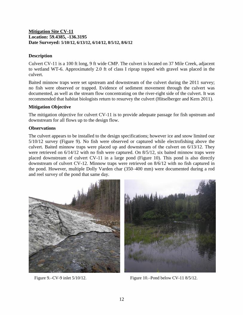
Mitigation Site CV-11
Location: 59.4385, -136.3195
Date Surveyed: 5/10/12, 6/13/12, 6/14/12, 8/5/12, 8/6/12
Description
Culvert CV-11 is a 100 ft long, 9 ft wide CMP. The culvert is located on 37 Mile Creek, adjacent
to wetland WT-6. Approximately 2.0 ft of class I riprap topped with gravel was placed in the
culvert.
Baited minnow traps were set upstream and downstream of the culvert during the 2011 survey;
no fish were observed or trapped. Evidence of sediment movement through the culvert was
documented, as well as the stream flow concentrating on the river-right side of the culvert. It was
recommended that habitat biologists return to resurvey the culvert (Hitselberger and Kern 2011).
Mitigation Objective
The mitigation objective for culvert CV-11 is to provide adequate passage for fish upstream and
downstream for all flows up to the design flow.
Observations
The culvert appears to be installed to the design specifications; however ice and snow limited our
5/10/12 survey (Figure 9). No fish were observed or captured while electrofishing above the
culvert. Baited minnow traps were placed up and downstream of the culvert on 6/13/12. They
were retrieved on 6/14/12 with no fish were captured. On 8/5/12, six baited minnow traps were
placed downstream of culvert CV-11 in a large pond (Figure 10). This pond is also directly
downstream of culvert CV-12. Minnow traps were retrieved on 8/6/12 with no fish captured in
the pond. However, multiple Dolly Varden char (350–400 mm) were documented during a rod
and reel survey of the pond that same day.
Figure 9.–CV-9 inlet 5/10/12. Figure 10.–Pond below CV-11 8/5/12.
13
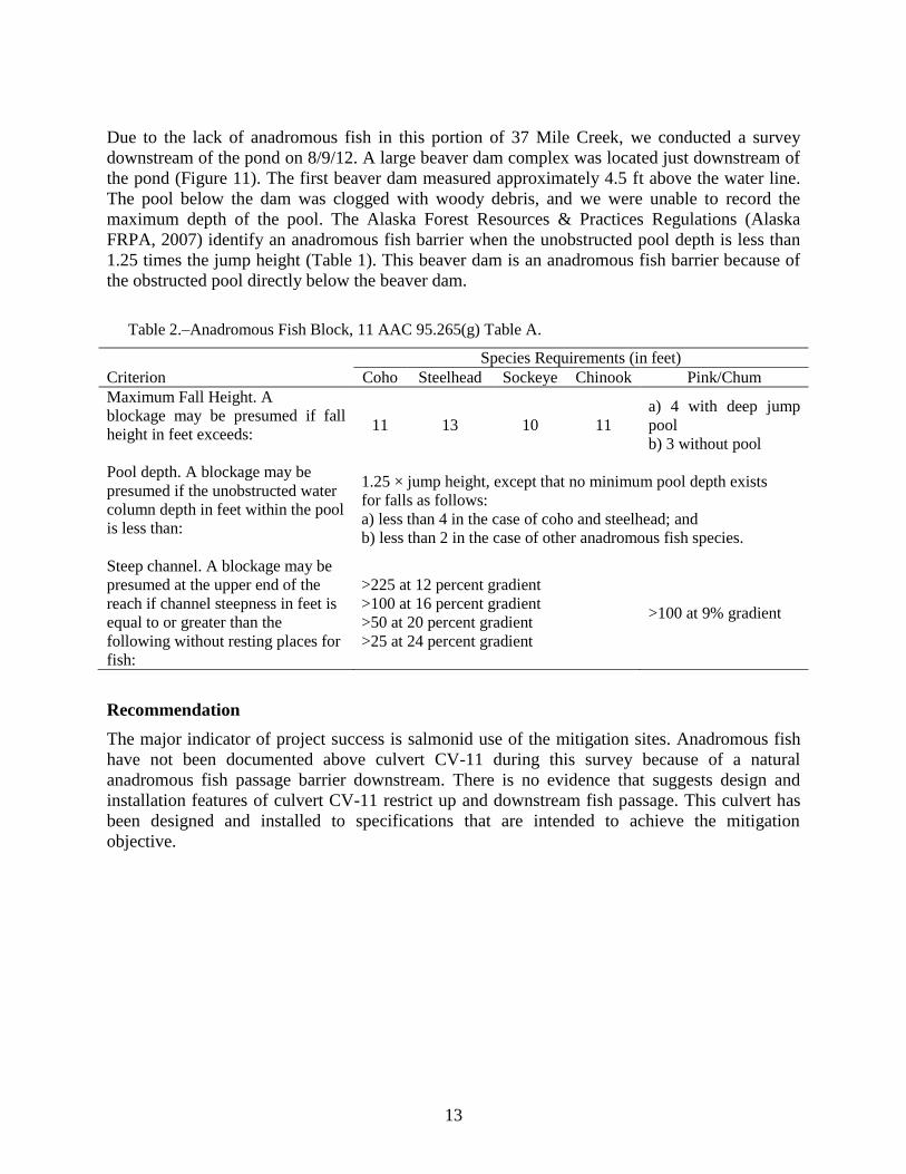
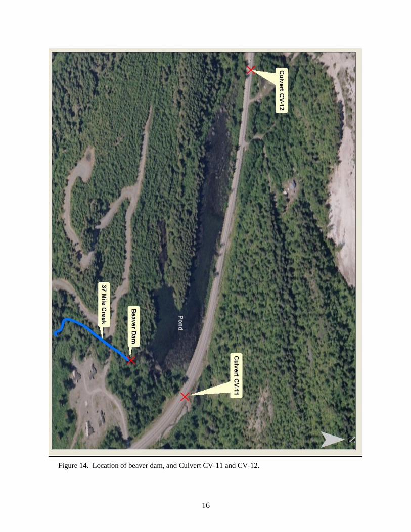
Due to the lack of anadromous fish in this portion of 37 Mile Creek, we conducted a survey
downstream of the pond on 8/9/12. A large beaver dam complex was located just downstream of
the pond (Figure 11). The first beaver dam measured approximately 4.5 ft above the water line.
The pool below the dam was clogged with woody debris, and we were unable to record the
maximum depth of the pool. The Alaska Forest Resources & Practices Regulations (Alaska
FRPA, 2007) identify an anadromous fish barrier when the unobstructed pool depth is less than
1.25 times the jump height (Table 1). This beaver dam is an anadromous fish barrier because of
the obstructed pool directly below the beaver dam.
Table 2.–Anadromous Fish Block, 11 AAC 95.265(g) Table A.
Species Requirements (in feet)
Criterion Coho Steelhead Sockeye Chinook Pink/Chum
Maximum Fall Height. A
blockage may be presumed if fall
height in feet exceeds:
11 13 10 11
a) 4 with deep jump
pool
b) 3 without pool
Pool depth. A blockage may be
presumed if the unobstructed water
column depth in feet within the pool
is less than:
1.25 × jump height, except that no minimum pool depth exists
for falls as follows:
a) less than 4 in the case of coho and steelhead; and
b) less than 2 in the case of other anadromous fish species.
Steep channel. A blockage may be
presumed at the upper end of the
reach if channel steepness in feet is
equal to or greater than the
following without resting places for
fish:
>225 at 12 percent gradient
>100 at 16 percent gradient
>50 at 20 percent gradient
>25 at 24 percent gradient
>100 at 9% gradient
Recommendation
The major indicator of project success is salmonid use of the mitigation sites. Anadromous fish
have not been documented above culvert CV-11 during this survey because of a natural
anadromous fish passage barrier downstream. There is no evidence that suggests design and
installation features of culvert CV-11 restrict up and downstream fish passage. This culvert has
been designed and installed to specifications that are intended to achieve the mitigation
objective.

14
Figure 11.–Beaver dam downstream of culvert CV-11 and CV-12.
Mitigation Site CV-12
Location: 59.4408, -136.3284
Date Surveyed: 5/10/12, 6/13/12, 6/14/12
Description
Culvert CV-12 is a 58 ft 6 in long by 13 ft 3 in by 6 ft 9 in aluminum box culvert (Figure 12 and
13). The culvert is located on Stream No. 115-32-10250-2077-3136-4053. Approximately 1.0 ft
of streambed material was placed in the culvert.
During the 2011 survey baited minnow traps were set near the culvert inlet and outlet. No fish
were observed or trapped during the survey. It was recommended that habitat biologists return to
resurvey the culvert (Hitselberger and Kern 2011).
Mitigation Objective
The mitigation objective for culvert CV-12 is to provide adequate passage for fish upstream and
downstream for all flows up to the design flow.
Observations
The culvert is installed to the design specifications, and streambed material (sand) within the
culvert is stable. Water velocity through the culvert does not change and there is no indication
that the culvert represents a fish passage barrier. No fish were observed or captured while
electrofishing above the culvert on 5/10/12. Baited minnow traps were placed up and
downstream of the culvert on 6/13/12. They were retrieved on 6/14/12 and no fish were captured.
15
Recommendation
During this survey, anadromous fish were not documented above culvert CV-12 because of a
downstream anadromous fish barrier (Figure 14). The culvert is designed and installed to
specifications and there are no modifications needed to provide adequate passage for fish
upstream and downstream.
Figure 12.–CV-12 outlet 6/13/12. Figure 13.–Upstream of CV-12 6/13/12.
16
Figure 14.–Location of beaver dam, and Culvert CV-11 and CV-12.
17
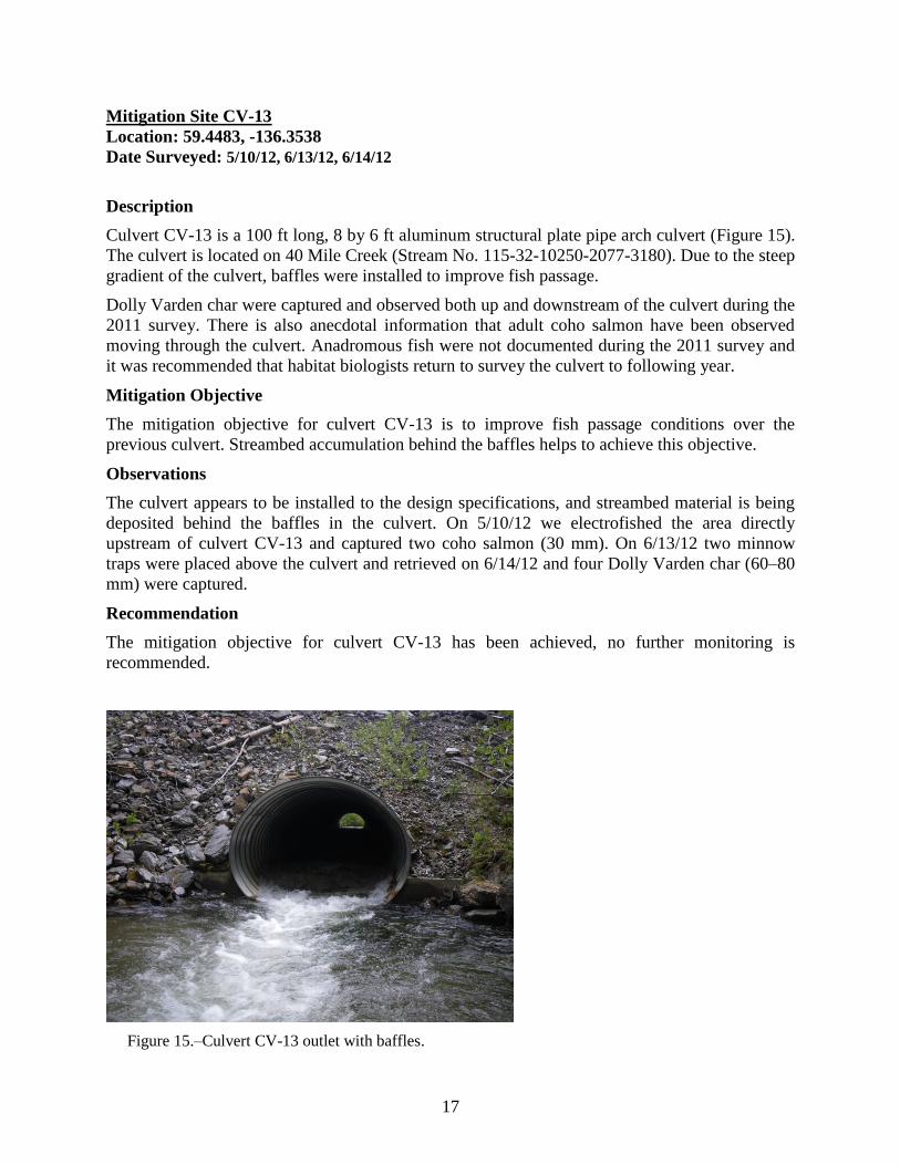
Mitigation Site CV-13
Location: 59.4483, -136.3538
Date Surveyed: 5/10/12, 6/13/12, 6/14/12
Description
Culvert CV-13 is a 100 ft long, 8 by 6 ft aluminum structural plate pipe arch culvert (Figure 15).
The culvert is located on 40 Mile Creek (Stream No. 115-32-10250-2077-3180). Due to the steep
gradient of the culvert, baffles were installed to improve fish passage.
Dolly Varden char were captured and observed both up and downstream of the culvert during the
2011 survey. There is also anecdotal information that adult coho salmon have been observed
moving through the culvert. Anadromous fish were not documented during the 2011 survey and
it was recommended that habitat biologists return to survey the culvert to following year.
Mitigation Objective
The mitigation objective for culvert CV-13 is to improve fish passage conditions over the
previous culvert. Streambed accumulation behind the baffles helps to achieve this objective.
Observations
The culvert appears to be installed to the design specifications, and streambed material is being
deposited behind the baffles in the culvert. On 5/10/12 we electrofished the area directly
upstream of culvert CV-13 and captured two coho salmon (30 mm). On 6/13/12 two minnow
traps were placed above the culvert and retrieved on 6/14/12 and four Dolly Varden char (60–80
mm) were captured.
Recommendation
The mitigation objective for culvert CV-13 has been achieved, no further monitoring is
recommended.
Figure 15.–Culvert CV-13 outlet with baffles.
18
CONCLUSION
Stream channels are reliant on seasonal water flows to function properly. In 2011, monitoring
occurred during a period of low flow and seven sites did not appear to meet their mitigation
objectives. In 2012, monitoring occurred during periods of higher water and biologists
documented these sites conveying flow and providing anadromous fish habitat when water is
available. Our notable findings follow:
Both of the stream channels achieve the mitigation objectives;
All five of the culverts achieve the mitigation objectives;
Coho salmon above CV-10 and CV13 are now documented where anadromous fish were
not documented during the previous survey;
Culvert CV-9 does not create a velocity barrier; and,
A natural barrier currently blocks anadromous fish from accessing culverts CV-11 and
CV-12. These two culverts are built to the design specification and are stable, so should
not present a fish passage barrier.
19
REFERENCES CITED
Alaska FRPA ( Forest and Resources Practices Act) Regulations, 2007, 11 AAC 95.265(g)(7) Table A: Anadromous
Fish Blockage.
Hitselberger, J. P. and M. J. Kern. 2011. Haines Highway Mile 25 to the border: 10-year mitigation monitoring.
Alaska Department of Fish and Game, Technical Report No.11-10, Douglas, Alaska.
Inter-Fluve Inc. 2000. Haines Highway Mile 25 to the border mitigation monitoring plan.
Johnson, J. and P. Blanche. 2011. Catalog of waters important for spawning, rearing, or migration of anadromous
fishes - Interior region, effective June 1, 2011. Alaska Department of Fish and Game, Special Publication No.
11-05, Anchorage.
Kondolf, G. M., and M. G. Wolman. 1993. The sizes of salmonid spawning gravels. Water Resources Research. Vol
29(7):2275–2285.
Magnus, D. L., A. D. Brandenburger, K. F. Crabtree, K. A. Palke, and S. A. MacPherson. 2006. Juvenile salmon
capture and coded wire tagging manual. Alaska Department of Fish and Game, Special Publication No. 06-31,
Anchorage, Alaska.
Pollard, W. R., G. F. Hartman, C. Groot and P. Edgell. 1997. Field identification of coastal juvenile salmonids.
Harbour Publishing.