Embed Size (px)
DESCRIPTION
Texts: Savas Paragamian and Kaloust Paragamian. Text on the flora of the gorge: by Manolis Avramakis Photographs: Manolis Avramakis, Antonis Chalkiadakis, Τolis Kaparounakis, Stavros Lazaridis, Andreas Meladakis, Ioannis Nikoloudakis, Kaloust Paragamian, Savas Paragamian, Fondas Spinthakis Cover photo: Andreas Meladakis Mapping: Savas Paragamian Mapping graphics: Eleni Sfakianaki Published by: Hellenic Institute of Speleological Research Publication funded by: Local Programme of Axis 4 “Implementation of LEADER Approach” of the Rural Development Programme 2007-2013, implemented by the Local Action Group of the Lassithi Local Development Agency S.A. Graphic design: Aris Totomis English translation: Rosemary Tzanaki Editing of English text: Afroditi Kardamaki, Anastasia Vassiliou Recommended reference: Paragamian, S. and K. Paragamian. 2015. Ha Gorge: Exploring a spectacular Hidden Landscape. Hellenic Institute of Speleological Research. Heraklion, 64pp. ISBN: 978-618-82232-1-9
Citation preview


HELLENICINSTITUTE OF
SPELEOLOGICAL RESEARCH

Texts: Savas Paragamian and Kaloust Paragamian. Text on the flora of the gorge: by Manolis AvramakisPhotographs: Manolis Avramakis, Antonis Chalkiadakis, Τolis Kaparounakis, Stavros Lazaridis, Andreas Meladakis, Ioannis Nikoloudakis, Kaloust Paragamian, Savas Paragamian, Fondas SpinthakisCover photo: Andreas MeladakisMapping: Savas ParagamianMapping graphics: Eleni SfakianakiPublished by: Hellenic Institute of Speleological ResearchPublication funded by: Local Programme of Axis 4 “Implementation of LEADER Approach” of the Rural Development Programme 2007-2013, implemented by the Local Action Group of the Lassithi Local Development Agency S.A.Graphic design: Aris TotomisEnglish translation: Rosemary TzanakiEditing of English text: Afroditi Kardamaki, Anastasia VassiliouRecommended reference: Paragamian, S. and K. Paragamian. 2015. Ha Gorge: Explor-ing a Spectacular Hidden Landscape. Hellenic Institute of Speleological Research. Her-aklion, 64pp.ISBN: 978-618-82232-1-9
Hellenic Institute of Speleological Research82 Ethnikis Antistaseos Avenue, Heraklion 71306, Crete, Greece.Τ: 2810 327459, F: 2810 327459, E: [email protected] www.inspee.gr
The Hellenic Institute of Speleological Research holds the publication’s copyright. The pho-tographers hold the photographs copyrights. Reproduction, use or republication in whole or in parts without the prior written consent of the Hellenic Institute of Speleological Research is prohibited.
HELLENIC INSTITUTE OF SPELEOLOGICAL RESEARCH
EUROPEAN AGRICULTURAL GUIDANCE & GUARANTEE FUND: EUROPE INVESTS IN RURAL AREAS
RURAL DEVELOPMENT PROGRAMME OF
GREECE 2007-2013
LASSITHI LOCAL DEVELOPMENT AGENCY S.A.
MINISTRY OF RURAL DEVELOPMENT & FOOD
LEADER

Preface 05 Introduction 09 Creation of the Gorge 13 Flora 17 Fauna 21 Ancient Settlements 25 The Sanctity of The Site 29 History of The Exploration & Bolting of Ha Gorge 30 Modern Bolting & Mapping of Ha & Mastoras Gorges 33 Climbing Fields in Ha Gorge 37 Crossing The Gorge of Ha 39 Descent: Following The Path of The Water 45 Mastoras Gorge & Waterfall 53 State of Preservation, Protection & Threats 59 Βibliography 63 Technical Information of Gorges (Τables) 64
CONTENTS
04
PREFACE HA GORGE
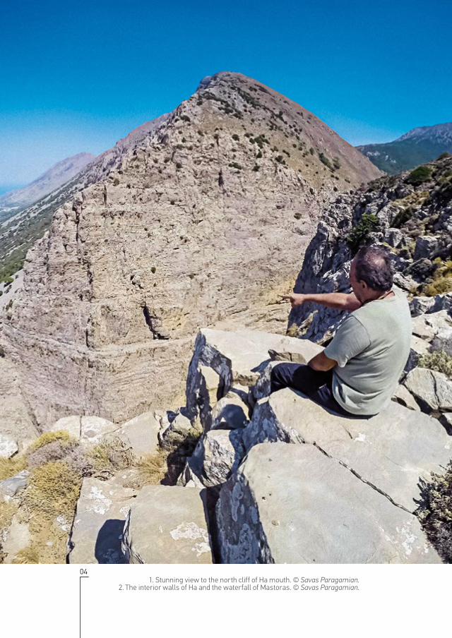
1. Stunning view to the north cliff of Ha mouth. © Savas Paragamian.2. The interior walls of Ha and the waterfall of Mastoras. © Savas Paragamian.

05
This publication is one of the actions implemented by the Hellenic In-stitute of Speleological Research as part of the project: “Ha: The most magnificent gorge in Crete”; promoting public environmental aware-
ness regarding the value and importance of the gorge. The project forms part of the Local Programme of Axis 4 “Implementation of LEADER Ap-proach” of the Rural Development Programme 2007-2013, implemented by the Local Action Group of the Lassithi Local Development Agency S.A. in the interior of Lassithi Prefecture.
Seven expeditions were carried out by 14 canyoners and scientists (six descends in total) in order to collect primary material and data. The gorge was mapped, photographed and videoed in detail, and observations were made regarding its geology, flora and fauna. Furthermore, all the anchor bolts were replaced with high-quality stainless steel bolts glued to the rock with epoxy resin in order to meet the requirements of safety and safe passage for hundreds of canyoners each year.
PREFACE
2.
1.

06
PREFACE HA GORGE
We would like to seize this opportunity to express our warmest thanks to our colleagues from the Hellenic Speleological Society, department of Crete, Nikos Aggelakis, Nikos Axiotis, Stefanos Apostolidis, Antonis Chalkiadakis, Antonis Dettorakis, Savvas Eftychis, Tolis Kaparounakis, Christos Lazaridis, Andreas Meladakis, Gina Panopoulou, Dimitris Pa-pagiannidis and Manos Petrakis, and to Stelios Papoutsakis from the Greek Mountaineering Club of Chania for their vital contribution in bolt-ing, photographing and video recording of Ha and Mastoras gorges. We would also like to thank the Greek Mountaineering Club of Chania and the Speleological Association of Crete for lending us the extra equipment necessary to carry out the expeditions, and Mr. Giorgos Rapanakis and the Pachia Ammos Cultural Association for their warm hospitality. Fi-nally, we thank the botanist Manolis Avramakis from the Natural History Museum of Crete, who provided us with observations on the flora of the gorge, the climber Fondas Spinthakis and the speleologist Kostas Adam-opoulos for their informations about the exploration of Ha gorge and Ar-chimandrite Kyrillos Diamantakis from the Holy Metropolis of Hierapytna and Sitia for the provided information on the churches of Agio Pneuma and Agia Anna.
1. A view of Ierapetra fault and Ha gorge from Pachia Ammos village. © Ioannis Nikoloudakis.
2. The interior of the gorge seen from Katalymata archeological site. © Ioannis Nikoloudakis.
2.1.

07
PREFACEHA GORGE

08
INTRODUCTION HA GORGE
1. The pine forest and the Afentis summit of Thrypti mountain. © Ioannis Nikoloudakis.2. © Manolis Avramakis.
09
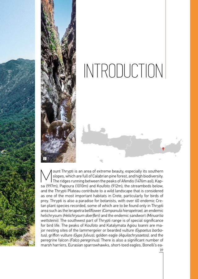
Mount Thrypti is an area of extreme beauty, especially its southern slopes, which are full of Calabrian pine forest, and high biodiversity. The ridges running between the peaks of Afendis (1476m asl), Kap-
sa (997m), Papoura (1010m) and Koufoto (912m), the streambeds below, and the Thrypti Plateau contribute to a wild landscape that is considered as one of the most important habitats in Crete, particularly for birds of prey. Thrypti is also a paradise for botanists, with over 60 endemic Cre-tan plant species recorded, some of which are to be found only in Thrypti area such as the Ierapetra bellflower (Campanula hierapetrae), an endemic helichrysum (Helichrysum doerfleri) and the endemic sandwort (Minuartia wettsteinii). The southwest part of Thrypti range is of special significance for bird life. The peaks of Koufoto and Katalymata Agiou Ioanni are ma-jor nesting sites of the lammergeier or bearded vulture (Gypaetus barba-tus), griffon vulture (Gyps fulvus), golden eagle (Aquilachrysaetos), and the peregrine falcon (Falco peregrinus). There is also a significant number of marsh harriers, Eurasian sparrowhawks, short-toed eagles, Bonelli’s ea-
INTRODUCTION
2.
1.

10
INTRODUCTION HA GORGE
gles, booted eagles, buzzards, and other raptors. At lower altitudes one can see cuckoos, chaffinches, crested larks, blackbirds, golden orioles, and other birds of brush and scrubland; alongside many farmland species.
The gorge of Ha is the most impressive geological feature of the Isthmus of Ierapetra and it is located on the west slope of Mt. Thrypti. The deep, vertical, V-shaped cleft in the hard mountain rocks and its towering cliffs are an awe-inspiring sight. The gorge was firstly referenced by the Italian Ciriaco de’ Pizzicolli or Cyriacus of Ancona (1391-1452); the greatest anti-quarian of the Renaissance and a precursor of modern sightseeing and archaeology. He saw Ha on the 23rd of October 1445, and described it as “a spring of Artemis Dictaea; carved in the living rock by Nature herself and with the Creator as its architect...” He also stated that the local inhabitants (even the priests) reported to him that they had seen the goddess Artemis and her gorgeous nymphs bathing naked in the transparent waters...
Unique places such as the gorge of Ha have indisputably been desirable objects for exploration since men first laid eyes on them. Yet it was not until 1987 that the gorge was crossed for the first time.
1. The pine tree forest of Thrypti at the beginning of Ha gorge. © Kaloust Paragamian.2. Water flows only a few months per year. © Ioannis Nikoloudakis.
2.1.

11
INTRODUCTIONHA GORGE

12
CREATION OF THE GORGE HA GORGE
1. Flowing water deepens the riverbed of the canyon over several hundreds of thousands of years. © Andreas Meladakis.
2. © Ioannis Nikoloudakis.

13
The gorge of Ha has been incised into platy limestone by mechanical water erosion. The water entering the gorge comes from a drain-age basin area of approximately 8 square kilometers, delimited by
an imaginary line connecting the highest points of the ridges around the village of Thrypti. This watershed ranges in altitude from 500 to 1476 me-ters above sea level (Afendis Estavromenos peak). At the beginning of the gorge is a 6-meter waterfall followed by another 27 falls, the highest of which measures 30 meters. Another waterfall, Mastoras, cascades ver-tically down the south wall of the gorge and its water flows into roughly the midpoint of the chiasm. This is one of the largest waterfalls in Greece, 215 meters high!
The gorge has been formed approximately in the centre of the largest fault of eastern Crete. The Ierapetra fault as it is known, is 25 kilome-ters long and was created several million years ago, causing the rise of the mountains of Thrypti and Ornos. The Isthmus of Ierapetra remained
CREATION OF THE GORGE
2.
1.

14
CREATION OF THE GORGE HA GORGE
part of the seabed for millions of years, filling up with marine sediments and fossils. The fault has been active for at least 2.5 million years. It is estimated that over the past 400,000 years Thrypti and Ornos have been rising at a rate of 0.1 to 0.4mm per year. Most of the Ierapetra fault face is visible from Pachia Ammos, while the fault scarp is apparent on either side of gorge mouth. A careful look will reveal a light-coloured band ap-proximately one meter wide created from the continuous uplift during the past 10,000 years. The Ierapetra fault has caused many earthquakes. The largest recorded occurred in May 1508 (7.2R magnitude) and in October 1780 (7.0R magnitude), both of which caused extensive damages and led to many casualties.
The swift uplift of Thrypti over the last few hundred thousand years re-sulted in the rapid deepening of Ha’s riverbed due to water erosion. Today, the gorge is 700 meters long in section, with a 325 meters difference in elevation between the entrance and the exit (from 480 to 155m above sea level). The riverbed is very narrow along most of its length, ranging from 1 to 10 meters wide.
1. & 2. Horizontal marble layers in the almost vertical cliffs of the gorge. © Ioannis Nikoloudakis.
3. Ierapetra fault and Ha gorge location (modified from Gaki-Papanastassiou et al. 2009)
2.1.

15
CREATION OF THE GORGEHA GORGE
3.

16
FLORA HA GORGE
1. The laminated vertical cliffs of Ha gorge are a true botanical heaven for cahasmophytes. © Ioannis Nikoloudakis.
2. Ierapetra bellflower (Campanula hierapetrae). © Ioannis Nikoloudakis.

17
The flora of Ha gorge is particularly interesting because it combines different types of vegetation, including a large number of endemic Cretan species and at least one species in the Red Book of Rare and
Endangered Plants of Greece.
At the eastern “entrance” of the gorge lies a fairly extensive forest of Cal-abrian pine (Pinus brutia) is located, which currently is recovering from the fires of 1984 and 1987. The clearings and the slopes leading up to the gorge entrance are covered with dense scrub, known as phrygana, containing many of the common scrub species of Crete such as the sage (Salvia fruti-cosa), the endemic Jerusalem sage (Phlomis lanata), the Mediterranean thyme (Thymbra capitata), the spiny broom (Genistaacanthoclada) and many tuberous plants like squill (Drimia numidica) and asphodel (Aspho-delus ramosus).
At the western “exit” of the gorge, around the stream bed that forms its nat-
FLORA
2.
1.

18
FLORA HA GORGE
ural continuation, we can observe typical riverine vegetation with chaste trees (Vitex agnus-castus), fig trees (Ficus carica), and oleander (Nerum ole-ander), combined with hard-leaved evergreens such as carob (Ceratonia siliqua), and lentisk (Pistacia lentiscus). On either side of the stream, exist modern olive groves, the remains of older olive and almond groves.
However, the most fascinating plants are the ones inside the gorge. Dom-inant plants in Ha are chasmophytes (plants growing in rock crevices), such as the greater chamaepeuce (Ptilostemon chamaepeuce), the Cretan mustard (Brassica cretica) and many endemic Cretan chasmophytes in-cluding the Cretan ebony (Ebenus cretica), the St. John’s wort (Hypericum amblycalyx), and the white crown vetch (Securigera globosa). Particularly interesting are the rock lettuce (Petromarula pinnata) since it is one of the two endemic genera of Crete and the silvery knapweed (Centaurea argen-tea subsp. argentea) which is a stenoendemic subspecies of eastern Crete and it is listed as “Least Concern” (LC) in the Red Book of Rare and Endan-gered Plants of Greece (2009).
1. Dragon arum (Dracunculus vulgaris). © Ioannis Nikoloudakis.2. White Crownvetch (Securigera globosa). © Manolis Avramakis.
2.1.

19
FLORAHA GORGE

20
FAUNA HA GORGE
1. Griffon vulture (Gyps fulvus). © Kaloust Paragamian.2. Red-billed Chough (Pyrrhocorax pyrrhocorax). © Andreas Meladakis.
21
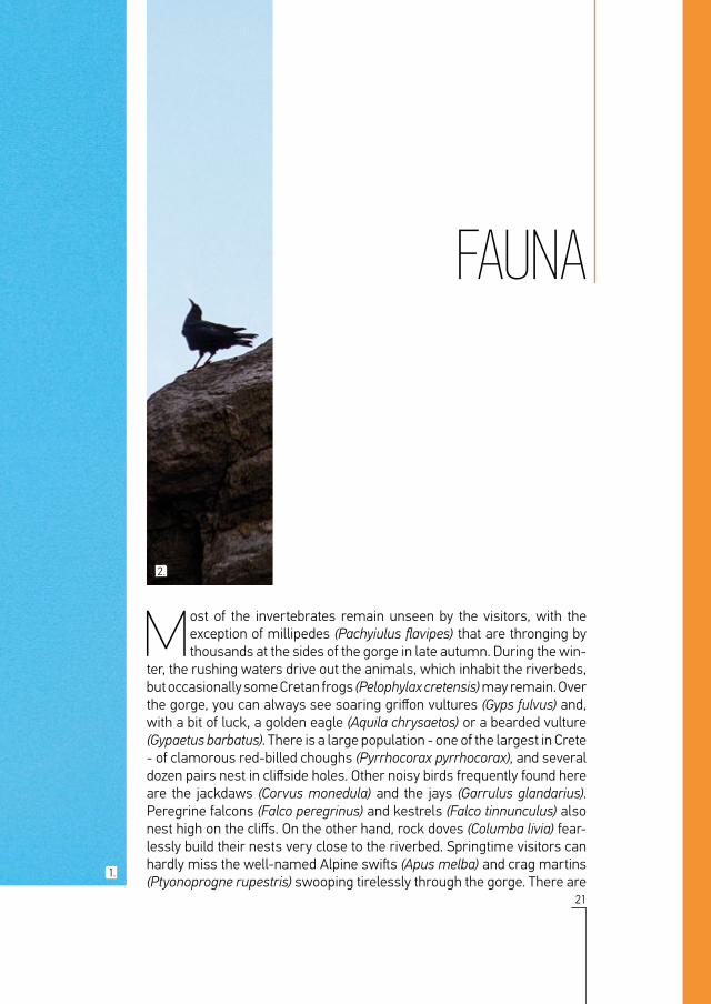
Most of the invertebrates remain unseen by the visitors, with the exception of millipedes (Pachyiulus flavipes) that are thronging by thousands at the sides of the gorge in late autumn. During the win-
ter, the rushing waters drive out the animals, which inhabit the riverbeds, but occasionally some Cretan frogs (Pelophylax cretensis) may remain. Over the gorge, you can always see soaring griffon vultures (Gyps fulvus) and, with a bit of luck, a golden eagle (Αquila chrysaetos) or a bearded vulture (Gypaetus barbatus). There is a large population - one of the largest in Crete - of clamorous red-billed choughs (Pyrrhocorax pyrrhocorax), and several dozen pairs nest in cliffside holes. Other noisy birds frequently found here are the jackdaws (Corvus monedula) and the jays (Garrulus glandarius). Peregrine falcons (Falco peregrinus) and kestrels (Falco tinnunculus) also nest high on the cliffs. On the other hand, rock doves (Columba livia) fear-lessly build their nests very close to the riverbed. Springtime visitors can hardly miss the well-named Alpine swifts (Apus melba) and crag martins (Ptyonoprogne rupestris) swooping tirelessly through the gorge. There are
FAUNA
2.
1.

22
FAUNA HA GORGE
many other notable bird species in the gorge of Ha, but the most melodi-ous song heard in this gigantic chasm is indisputably that of the blue rock thrush (Monticola solitarius).
1. Common buzzard (Buteo buteo). © Kaloust Paragamian.2. The endemic frog of Crete (Pelophylax cretensis). © Kaloust Paragamian).
3. Red-billed choughs nesting at the cliffs of the gorge. © Andreas Meladakis.
3.2.
1.

23
FAUNAHA GORGE

24
ANCIENT SETTLEMENTS HA GORGE
1. The ruins of the ancient settlement of Chalasmenos and the impressive screes of Ha. © Ioannis Nikoloudakis.
2. Katalymata settlement. © Savas Paragamian.

25
Archaeological findings at the exit of Ha show that there has been continuous human activity here since the Neolithic period, which increased during the turbulent times at the end of the Minoan era.
Just 280m southwest of the gorge’s exit, 230m above sea level, lay the ruins of Chalasmenos, the most important and perhaps the largest an-cient settlement of the 12th century BC. The excavation of the site, under-taken by the American School of Classical Studies and the 24th Ephorate of Prehistoric and Classical Antiquities, began in 1992 and revealed large rectangular buildings, roads or cobbled streets, open spaces, a public shrine containing rare vessels, and findings dating the site back to the Late Bronze Age. A total of 27 architectural units were excavated, spread out across an area of roughly 6,5 acres on Kefala Hill. As the lead excava-tor Prof. Metaxia Tsipopoulou records in several publications, the settle-ment was built, inhabited and abandoned for unknown reasons in the 12th century BC. The excavation findings show that there was some renewal of
ANCIENT SETTLEMENTS
2.
1.

26
ANCIENT SETTLEMENTS HA GORGE
activity in the 8th century BC. The hill allowed the inhabitants to watch over both the Cretan and the Libyan Seas, while cultivating their crops down in the fertile valley.
In the mouth of the gorge, midway along Papoura cliff, are the ruins of another settlement that the locals call “Katalymata”. As archaeologist Prof. Krzysztof Nowicki revealed in 1989-1990, this site was probably a little older than that of Chalasmenos. It was also used in the recent past, as a refuge for the local inhabitants during the Turkish and German oc-cupations of Crete. Katalymata is in a particularly inaccessible area. To get there, you must first climb 170-180m up the north moraine and then walk along a natural limestone ledge along the sheer cliff of Papoura to the edge of the north slope of Ha gorge. The ledge is 40m long and aver-ages 1m wide. The settlement occupies at least eight horizontal shelves of platy limestone with a difference in elevation of 65m, from 280 to 345m above sea level, comprising the ruins of at least 10 architectural units, houses or groups of houses, over an area of 3,5 acres. The site is visible from above, from the sheer south side of the gorge, and also from Cha-lasmenos.
Katalymata is truly a breathtaking place. The archaeological site itself in-duces awe and thrill. Your gaze is drawn firstly upward into the gorge and the majestic waterfall of Mastoras, then towards the view of the seas to north and south of Crete, and Mt. Dicte
1. The path to Katalymata. © Savas Paragamian.2. The ruins of the ancient settlement of Katalymata,
a breathtaking place. © Savas Paragamian.
2.1.

27
ANCIENT SETTLEMENTSHA GORGE

28
THE SANCTITY OF THE SITE HA GORGE
1. The church of Agia Anna (St. Anne) at Thrypti. © Kaloust Paragamian.2. Carved inscriptions of Venetian travelers on the wall-paintings. © Kaloust Paragamian.
3. The church of Agio Pneuma (Holy Spirit) at the exit of Ha. © Ioannis Nikoloudakis.

29
The earliest indications of the sanctity of the site are found in the ancient settlement of Chalasmenos. On the north side of the site
a large rectangular building was excavated, the public shrine of the community. In contrast to the Minoan period, the public shrine at Chalasmenos,
was built and used in the 12th century BC, and was easily accessed by a cobbled pathway leading up to the entrance.
Nevertheless, the sanctity of the site survives through the ages. Near the gorge exit, exists the single-chamber barrel-vaulted church of Agio Pneu-ma (Holy Spirit). The decorative plates embedded in the outer wall show that it was probably built during the Venetian period. According to earli-er testimonies and the ruined cells that were visible until recently, it may have been the main church of a small monastery, after which the village of Monastiraki is presumably named. Near the gorge entrance stands an-other single-aisled barrel-vaulted church, that of Agia Anna (St. Anne). The church was restored in 1998 and it is full of wall-paintings from the early 15th century, onto which Venetian travellers have carved inscriptions (dates and names). The dates written on the wall-paintings are: 1445, 1456, 1459, 1465, 1471, 1477, 1489 and 1551, along with the names which were very of-ten preceded by “hic fuit”, meaning “was here”. One of the names is that of ANDREAS CORNERIUS, probably a member of the great Kornaros family.
THE SANCTITY OF THE SITE
3.
2.
1.

30
Although humans have been present in the area for thousands of years, the interior of this gorge -symbol of eastern Crete was ex-plored in 1987! Between the 17th and the 23rd of June of 1987 three
climbers from Thessaloniki, Stavros Lazaridis, Vlassis Chatzipanayiotou and Chronis Amantzidis, made the risky decision to ascend the gorge from the exit to the entrance, without knowing the conditions occurring inside the gorge. The strenuous seven days effort crossing Ha was a tremendous achievement, since they did not only explore the gorge, but they ascended it as well. Even today, with the modern means and a detailed map, ascend-ing Ha gorge is an extremely hard task due to the sheer walls, smoothed by erosion and water deposits, and the 27 waterfalls which combined in-crease exponentially the difficulty of the climb.
A decade later, in 1997, Stavros Lazaridis, Giorgos Galos, Michalis Tsoukias and Giorgos Tsakalakis repeated the crossing of Ha gorge. This time they did it the conventional way: descending from the entrance to the exit. The
HISTORY OF THE EXPLORATION & BOLTING OF HA GORGE
1.

31
HISTORY OF THE EXPLORATION & BOLTING OF HA GORGEHA GORGE
following year, the climbers Thodoris Petropoulos, Fondas Spinthakis and Polykarpos Tzikas also descended the gorge. The descent of Ha was re-peated again in 1999 by a team of speleologists and climbers: Kostas Ad-amopoulos, Manolis Diamantopoulos, Fontas Spinthakis and Methodios Psomas. The gorge was then accessible by more teams, thanks to the bolts already set and the instructions provided by the previous groups.
In 2002, when canyoning techniques had become familiar in Greece, Gior-gos Andreou, Spyros Lakkas and Giorgos Adamasoglou installed anchors in the gorge in line with the international canyoning bolting standards. The bolting was finished two years later by the Hellenic Canyoning Club. How-ever, the exploration of Ha was completed in February of 2008, after the exploration of the gorge of Mastoras, which ends vertically in the middle of the gorge of Ha via a 215 - meter waterfall - one of the highest explored waterfalls in Greece. Mastoras was bolted by Yannis Bromirakis, Savas Paragamian, Katerina Hatzidimitriu and Maya Christodoulaki of the Cre-tan Canyoning Association and the Hellenic Speleological Society, Depart-ment of Crete.
Exploring, improving the bolting and publishing the information of a gorge are necessary acts in order for hidden and impressive landscapes (such as that of the gorgeof Ha) to be travelled, admired, and studied by the rest of canyoning community. Unfortunately, not everyone shares this helpful attitude. In 2009 unknown persons removed all the material placed by the Hellenic Canyoning Club in 2004. The gorge was re-bolted the same year by the Hellenic Speleological Society, Department of Crete and the Greek Mountaineering Club of Chania
1. Vlassis Chatzipanayiotou climbing the vertical wall of Ha. © Stavros Lazaridis.2. Fondas Spinthakis installing one of the first bolts in Ha. Archive of Fondas Spinthakis.
2.

32
MODERN BOLTING & MAPPING OF HA & MASTORAS GORGES HA GORGE
1. Installing anchors with resin at the first rappel of Mastoras waterfall. © Tolis Kaparounakis.
2. © Tolis Kaparounakis.
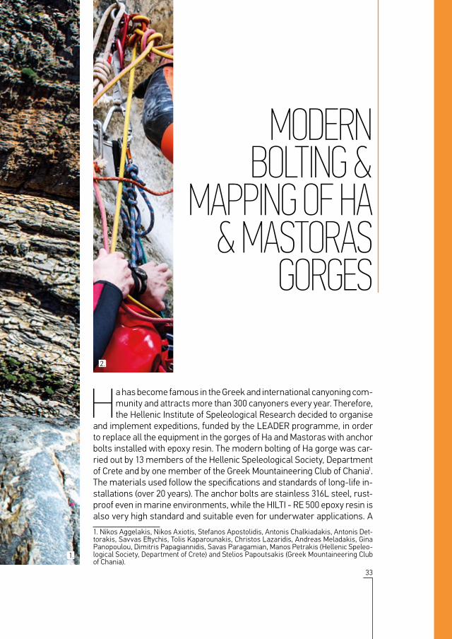
33
Ha has become famous in the Greek and international canyoning com-munity and attracts more than 300 canyoners every year. Therefore, the Hellenic Institute of Speleological Research decided to organise
and implement expeditions, funded by the LEADER programme, in order to replace all the equipment in the gorges of Ha and Mastoras with anchor bolts installed with epoxy resin. The modern bolting of Ha gorge was car-ried out by 13 members of the Hellenic Speleological Society, Department of Crete and by one member of the Greek Mountaineering Club of Chania1. The materials used follow the specifications and standards of long-life in-stallations (over 20 years). The anchor bolts are stainless 316L steel, rust-proof even in marine environments, while the HILTI - RE 500 epoxy resin is also very high standard and suitable even for underwater applications. A
1. Nikos Aggelakis, Nikos Axiotis, Stefanos Apostolidis, Antonis Chalkiadakis, Antonis Det-torakis, Savvas Eftychis, Tolis Kaparounakis, Christos Lazaridis, Andreas Meladakis, Gina Panopoulou, Dimitris Papagiannidis, Savas Paragamian, Manos Petrakis (Hellenic Speleo-logical Society, Department of Crete) and Stelios Papoutsakis (Greek Mountaineering Club of Chania).
MODERNBOLTING &
MAPPING OF HA & MASTORAS
GORGES
2.
1.

34
MODERN BOLTING & MAPPING OF HA & MASTORAS GORGES HA GORGE
total of 59 bolts and 7 chains were placed in Ha, and 24 bolts and 4 chains in Mastoras. Once the bolting was completed, 58 canyoners from Crete and France made a celebratory descent of the gorge of Ha.
Gorge cartographies usually include in detail only the descents (water-falls) and specific points of interest or caution for the canyoners/visitors. Even though, previous maps of Ha gorge had been published, due to the recent re-bolting of Ha and Mastoras we had to redo their cartography. Despite the commonly followed practice of a less detailed mapping we decided to accurately remap them horizontally and vertically by using the same scale and by following the morphology of the landscape. The terrain, the vegetation and the rocks make every part of the gorge unique. The illustration of the water makes the waterfalls more vivid and also shows the depth and length of the pools, making it clear where jumps and slides are possible. The detailed illustration of the bolting indicates the descent routes and their technical difficulties. The main points at the entrance and exit of the gorge such as the churches and the access paths are sketched in, helping to provide a overall picture. The two gorges cross each other almost vertically (85ο), with Mastoras to be finishing at the south wall of the gorge of Ha.
1. Celebration of the completion of the modern bolting of Ha and the Initiator Training Course of the French Federation of Speleology. © Kaloust Paragamian.
2. Resin injection. © Andreas Meladakis.3. Drilling, cleaning, injecting resin and installing
the anchors. © Savas Paragamian.
2.1.

35
MODERN BOLTING & MAPPING OF HA & MASTORAS GORGESHA GORGE
3.

36
CLIMBING FIELDS IN HA GORGE HA GORGE
1. Climbing routes on the cliffs of Ha gorge. © Ioannis Nikoloudakis.2. Last belay of a climbing route that reaches Katalymata. © Savas Paragamian.

37
Canyoning allows you to cross and explore a gorge with waterfalls. However, the vertical walls of Ha are also of interest to climbers. The famous Austrian climber Albert Precht1 and Sigi Brachmayer,
together with other climbing partners, have opened 6 routes in the gorge of Ha, 4 at Monastiraki and dozens of others in the surrounding area. The routes in Ha can be approached from the gorge’s exit and they are lo-cated at the west face and the inner gorge walls. The two shorter routes extend 250 meters with 7 pitches, while the rest are 400 meters with 10 to 13 pitches. All routes are equipped with belay stations and interme-diate anchor bolts across each pitch, but friends and cams can be used as well. The routes difficulties range from IV to VI, while some passages have an increased difficulty of VII to VIII.
1. Sadly, Albert Precht, the man who opened the routes through Ha gorge, and his rope partner Robert Jölli died on 8 May 2015 in a climbing accident in Kapsas (Pervolakia) gorge in southeast Crete.
CLIMBINGFIELDS IN
HA GORGE
2.
1.

38
CROSSING THE GORGE OF HA HA GORGE
1. “...carved in the living rock by Nature herself and with the Creator as its architect...” Cyriacus of Ancona (1391-1452). © Kaloust Paragamian.
2. © Kaloust Paragamian.

39
Ha gorge is definitely one of the most impressive geological forma-tions in Crete. Ha gorge cuts into the west side of Mt. Thrypti and its V-shaped opening is a trademark of the wider Ierapetra area. Its
walls are near-vertical faces up to 350 meters high and their distance at the bottom of the gorge varies between 1 and 10 meters. Ha gorge is usu-ally entered 570 meters WNW of Agia Anna church, 1.5km NW of Thryp-ti village and at an altitude of 480m asl. Its exit is just 250 meters from the church of Agio Pneuma near Monastiraki, at 155m above sea level. Amazingly, the bed of the gorge drops 325 meters in a distance of just 700 meters!
The gorge contains 271 waterfalls and the largest is 30 meters high. The falls are consecutive with only a few meters distance from one to another and the longest walking section located at the end of the gorge is just 80 meters long. In several places you may have to swim when there is water
1. Overall, Ha contains 29 descents but the first 2 are rarely descended by canyoners due to their remoteness from the rest of the canyon.
CROSSING THE GORGE OF HA
2.
1.

40
CROSSING THE GORGE OF HA HA GORGE
in the gorge. Gorge difficulty is V4.A3.III according to international stand-ards and an experienced four-member team can descend it in 4.5 hours. Generally speaking, Ha is a medium-difficulty gorge with a bit of walking, low water flow and small falls. However, the relatively higher technical difficulties at 6 waterfalls and the fact that there is no escape (!) indicate that there is no room for error. Therefore, teams visiting the gorge must be very familiar with canyoning techniques.
INTERNATIONAL SCALE OF HA GORGE DIFFICULTY.V4: consecutive descents, approach traverses necessary, friction management skills.Α3: when water exists in the gorge the team is often in the water due to its narrowness, making it a hypothermia risk. Waterfall management skills necessary.III: no escapes after the 2nd descent, so the team cannot get out if there is a problem. A four-member team of autonomous canyoners needs 4.5 hours to descend the gorge.
1. Walking at the narrow riverbed of Ha. © Andreas Meladakis.2. The 25th descent of Ha, © Andreas Meladakis.
2.1.

41
CROSSING THE GORGE OF HAHA GORGE

42
HA GORGE V4.A3.III
4.5h 283°Ν
0m 100m 700m600m500m400m300m200m
INFORMATIONAZIMUTH PARKINGALTITUDEDIFFICULTY SCALE
TIME OF DESCENT
LENGTH OF TRAVERSE
SCRAMBLING DISTANCE
HEIGHT OF JUMP
HEIGHT OF SLIDE
DESCENT HEIGHT
HIGHESTDESCENT
WATER POOLANCHORS CONNECTED WITH CABLE
INCREMENTAL RAPPEL NUMBER
INCREASED ROPE FRICTION
TWO ANCHOR BOLTS
ROPE DEVIATION
WEDGED ROCK SPRINGGORGE WALL DAMVEGETATION ROCK
DIRT ROAD ASPHALT ROAD DISTANCE/TIME OF HIKING
CHURCH UTILITY POLE WATERMILL
TO THRYPTI
TO KATO HORIO
AGIA ANNA CHURCH
WATERFALL LEFT
Topo - Measurements: Savas Paragamian.Mapping graphics: Eleni Sfakianaki.

43
TOPO OF HA & MASTORAS GORGES
MASTORAS GORGE V5.A2.III
6h 8°Ν
0m 100m 700m600m500m400m300m200m
EXIT RIGHT
TO PACHIA AMMOS
TO KATO HORIO
AGIO PNEVMA CHURCH

44
DESCENT: FOLLOWING THE PATH OF THE WATER HA GORGE
1. Inside the white water curtain of the tenth waterfall. © Andreas Meladakis.2. The high and vertical walls of Ha as shown from the beginning of the 30 meter
waterfall. © Kaloust Paragamian.

45
Like most Cretan gorges, Ha is full of water after a rainfall and during snowmelt. The water flow period usually starts with the first rains in November and ends in May, but it depends directly on the annual
rainfall. In high-rainfall years the water flow in the gorge (though not after storms) does not exceed 100 l/s. Generally, from February to April is the best time to descend the gorge, as the pools are replenished with crystal-clear water and the gorge is full of life and colour. From May/June to November stagnant water lies in many pools and it often con-tains dead choughs, rats and goats.
Starting from the church of Agia Anna on Mt. Thrypti, where there is parking space, follow the E4 path along a dirt road to the gorge. Follow it for 300 meters to the electricity pole on your right and turn right onto the descending slope of the Ha Gorge. Walk 250 meters to the bed of the gorge, where vegetation is dense. Continue on into the gorge and in a few meters you will reach the first descent, 6 meters high, under a
DESCENT: FOLLOWING
THE PATH OF THE WATER
2.
1.

46
DESCENT: FOLLOWING THE PATH OF THE WATER HA GORGE
spring. You are now inside the gorge and the walls rise steeply above the bed. The next three descents are vertical, 9 to 14 meters high, while the gorge walls are 4-6 meters apart. At the base of the 4th waterfall is a pool 10x8 meters wide and 4 meters deep, allowing you to dive from the top of the drop.
A few meters further on, the bed of the gorge turns right and a marvel-lous view opens up. The high walls of Ha on either side, frame the plain of Ierapetra and the Lassithi Mountains. Here is the highest descent of Ha, 30 meters high. Its walls are neither compact nor smooth, so care must be taken when rappelling due to increased friction. Walk 20 me-ters to a 14-meter drop, which can be detoured as far as mid-height, and then jump into the pool. You are now at the 7th fall. Here the walls open out to 10 meters and a little vegetation appears at the bottom of the gorge. Looking up, you can see the walls rising 150 meters, full of chas-mophytes, while the choughs fly overhead in an impressive aerobatic display. After the 7th and the 8th descent, which is only 6 meters high, the gorge narrows and the descents are consecutive.
1. Color contrasts at the sixth descent. © Andreas Meladakis.2. © Tolis Kaparounakis.
2.1.

47
DESCENT: FOLLOWING THE PATH OF THE WATERHA GORGE

48
DESCENT: FOLLOWING THE PATH OF THE WATER HA GORGE
To the left of the watercourse, on a massive rock, starts a 16-meter de-scent ending on a small 3x1-meter shelf, where the 20 meters high 10th descent begins. At this point, you meet the water again which on the occasions that it flows exceeds 30 l/s, it falls from the right-hand wall to the opposite wall forming a white curtain of water that reduces visibility to just a few meters. The descent through the water starts blind, when you suddenly see an 8x5-meter pool surrounded by grey and orange limestone. The water flows over the end of the pool into an opening, just 1 meter wide and 6 meters long, before pouring into the next fall. An 8-meter approach traverse leads to the anchors of the 11th waterfall, which is 22 meters high, sloping and smooth due to travertine deposits. After jumping 7 meters into the 12th fall, continue for 20 meters. You are now at the midpoint of the route. The gorge opens out and to your left appears the waterfall of Mastoras, 215 meters high, falling into the bed of the gorge of Ha. The drop is as high as the walls but its base is not yet visible.
Against the background of the waterfall of Mastoras, you can make an-other 12-meter jump! This is followed by a 16-meter drop. At its foot is a 10-meter traverse on a horizontal layer of marble on the platy limestone, measuring 10x8 meters. At the edge of this shelf are the anchors of the 15th waterfall, 28 meters high. From there you can admire the view of the whole Mastoras drop and the rest of the gorge, definitely one of the best parts of the gorge! Mastoras flows into the pool at the base of this 15th fall. The next five waterfalls are 6 to 16 meters high, each 10 meters apart. Here, the walls of the gorge rise over 300 meters and the bed is just 3 meters wide, creating an awe-inspiring effect. You are now at the 21st descent, 8 meters high. At the bottom, 30 meters away and on the same level as the waterfall, is a distinctive erosion-rounded rock wedged between the walls. You follow the leveled part of the gorge with some walking and a swim for the next 80 meters. This ends in a 1-meter wide and 8 meters high slide, while two small 6-meter slides make this descent fun.

49
DESCENT: FOLLOWING THE PATH OF THE WATERHA GORGE
Along the rest of the gorge, the layers of the plattenkalk limestone are horizontal and coloured grey, mauve and orange. Looking up, you see another rock wedged 20 meters above. A few meters on, is the 25th de-scent, 15 meters high. An almost vertical 10-meter slide that bends left follows, making an impressive exit. Nevertheless be careful! You must check if there is water in the pool even when water is abundant through the gorge, as it is often drained dry by the locals. The lip of this pool has been built up to collect the water and run it along an aqueduct to power watermills. There is one more waterfall in the gorge, 15 meters high, but people usually make detour to the right by a 1-meter passage where we have placed a wire rope, leading 10 meters to a safe spot. From then on, it looks as though Ha gorge has been built up rock by rock due to the platy limestone. Five minutes’ walk along a dirt track and you are at the church of Agio Pneuma from where you can admire the gorge, just as impressive on the outside as it was on the inside.
1. The 15th descent, where Ha and Mastoras meet! © Savas Paragamian.
1.
50
DESCENT: FOLLOWING THE PATH OF THE WATER HA GORGE
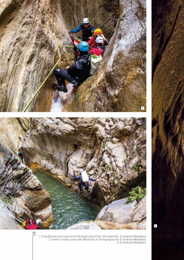
1. Crowded narrow traverse at the beginning of the 11th waterfall. © Andreas Meladakis.2. Twelve-meter jump with Mastoras in the background. © Andreas Meladakis.
3. © Andreas Meladakis.
3.2.
1.

51
DESCENT: FOLLOWING THE PATH OF THE WATERHA GORGE

52
MASTORAS GORGE & WATERFALL HA GORGE
1. Looking up from the base of the 1st rappel of Mastoras. © Savas Paragamian.2. At the middle of Mastoras while twisting around the rope. © Andreas Meladakis.

53
Ha has a side-gorge, the gorge of Mastoras, which runs south of Ha and meets it at a right angle, forming the waterfall of Mas-toras, 215 meters high. Crossing Mastoras requires 20 technical
descents, 9 of them in Mastoras and the rest are in the last part of the gorge of Ha. Before the great drop there are 5 short and sweet techni-cal descents giving the impression that this is a small, easy gorge. This section is narrow, 4-10 meters wide and 300 meters long with very low walls.
As soon as you reach the waterfall, you see the opposite wall of Ha 100 meters away. Looking down, you view almost the full section of the can-yon of Ha with the plain of Ierapetra on the left. An awesome sight!
The wild beauty of Mastoras is matched by the technical difficulties of its descent. The waterfall is divided into four descents due to its height. Approaching the 3 intermediate changes require great skills and expe-
MASTORAS GORGE &
WATERFALL
2.
1.
54
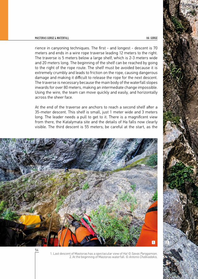
MASTORAS GORGE & WATERFALL HA GORGE
rience in canyoning techniques. The first - and longest - descent is 70 meters and ends in a wire rope traverse leading 12 meters to the right. The traverse is 5 meters below a large shelf, which is 2-3 meters wide and 20 meters long. The beginning of the shelf can be reached by going to the right of the rope route. The shelf must be avoided because it is extremely crumbly and leads to friction on the rope, causing dangerous damage and making it difficult to release the rope for the next descent. The traverse is necessary because the main body of the waterfall slopes inwards for over 80 meters, making an intermediate change impossible. Using the wire, the team can move quickly and easily, and horizontally across the sheer face.
At the end of the traverse are anchors to reach a second shelf after a 35-meter descent. This shelf is small, just 1 meter wide and 3 meters long. The leader needs a pull to get to it. There is a magnificent view from there, the Katalymata site and the details of Ha falls now clearly visible. The third descent is 55 meters; be careful at the start, as the
1. Last descent of Mastoras has a spectacular view of Ha! © Savas Paragamian.2. At the beginning of Mastoras waterfall. © Antonis Chalkiadakis.
2.1.

55
MASTORAS GORGE & WATERFALLHA GORGE

56
MASTORAS GORGE & WATERFALL HA GORGE
57
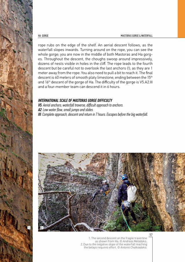
MASTORAS GORGE & WATERFALLHA GORGE
1. The second descent on the fragile travertine as shown from Ha. © Andreas Meladakis.
2. Due to the negative slope of the waterfall reaching the belays requires effort. © Antonis Chalkiadakis.
2.1.
rope rubs on the edge of the shelf. An aerial descent follows, as the waterfall slopes inwards. Turning around on the rope, you can see the whole gorge; you are now in the middle of both Mastoras and Ha gorg-es. Throughout the descent, the choughs swoop around impressively, dozens of nests visible in holes in the cliff. The rope leads to the fourth descent but be careful not to overlook the last anchors (!), as they are 1 meter away from the rope. You also need to pull a bit to reach it. The final descent is 60 meters of smooth platy limestone, ending between the 15th and 16th descent of the gorge of Ha. The difficulty of the gorge is V5.A2.III and a four-member team can descend it in 6 hours.
INTERNATIONAL SCALE OF MASTORAS GORGE DIFFICULTYV5: Aerial anchors, waterfall traverse, difficult approach to anchors.Α2: Low water flow, small jumps and slides.III: Complete approach, descent and return in 7 hours. Escapes before the big waterfall.

58
STATE OF PRESERVATION, PROTECTION & THREATS HA GORGE
1. Water reservoir at Ha gorge. © Kaloust Paragamian.2. Recent land clearings and excavations altered the landscape
in front of the gorge. © Kaloust Paragamian.
59
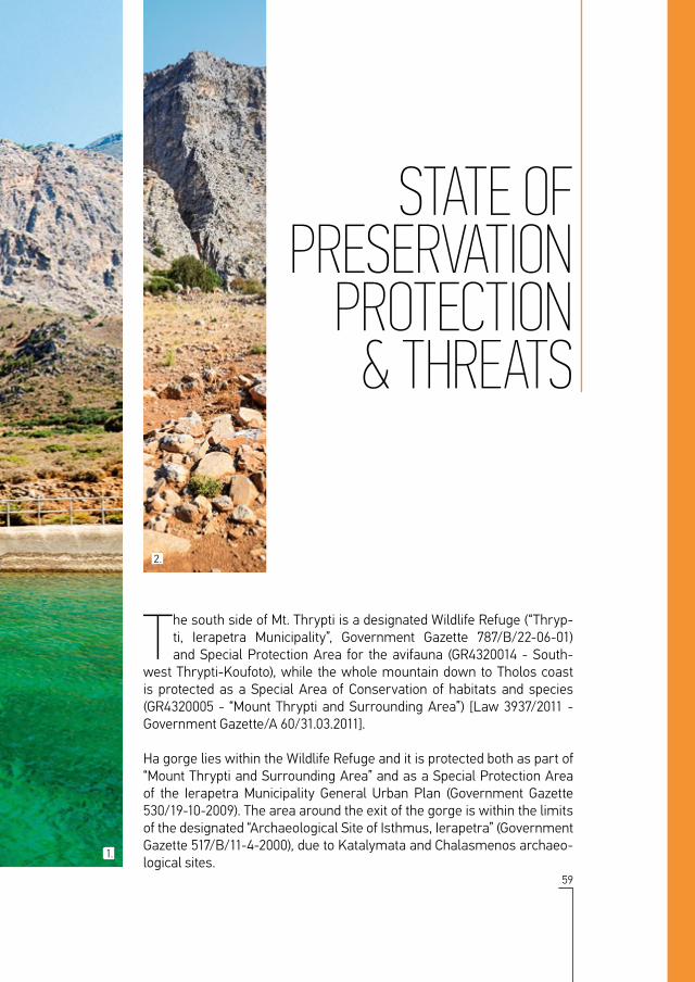
The south side of Mt. Thrypti is a designated Wildlife Refuge (“Thryp-ti, Ierapetra Municipality”, Government Gazette 787/Β/22-06-01) and Special Protection Area for the avifauna (GR4320014 - South-
west Thrypti-Koufoto), while the whole mountain down to Tholos coast is protected as a Special Area of Conservation of habitats and species (GR4320005 - “Mount Thrypti and Surrounding Area”) [Law 3937/2011 - Government Gazette/Α 60/31.03.2011].
Ha gorge lies within the Wildlife Refuge and it is protected both as part of “Mount Thrypti and Surrounding Area” and as a Special Protection Area of the Ierapetra Municipality General Urban Plan (Government Gazette 530/19-10-2009). The area around the exit of the gorge is within the limits of the designated “Archaeological Site of Isthmus, Ierapetra” (Government Gazette 517/Β/11-4-2000), due to Katalymata and Chalasmenos archaeo-logical sites.
STATE OFPRESERVATION
PROTECTION& THREATS
2.
1.

60
STATE OF PRESERVATION, PROTECTION & THREATS HA GORGE
The state of preservation of the gorge interior is exceptional, even though it is drained of large quantities of water. Unfortunately, the same cannot be said of the area immediately outside the exit of the gorge. There, the landscape is threatened by the expansion of the industrial area and illegal water extraction. However, a dirt road was built up to the exit a few years back! Ha stream is degraded down to where it meets the sea. The poorly designed recycling installations and vehicle inspection centres (MOT cen-tres) are horribly detrimental to the image of the natural monument. Even worse, very recently a large extent of the moraine north of the Ha Gorge exit was levelled, and, even more recently, an area of 1.4 hectares around the church of Agio Pneuma was reclaimed.
The gorge of Ha and the Isthmus of Ierapetra Fault are natural and geo-logical monuments, not only of Crete but of all of Greece. It is already a geotope of national importance. It has also been suggested that the sur-rounding area of approximately 480 hectares should be designated as an Area of Outstanding Natural Beauty.
As the degradation of the landscape at the exit of the gorge intensifies, it needs to be protected by law, by being incorporated into one of the protect-ed area categories set out under Law 3937/2011, “Protection of Biodiversi-ty and Other Regulations”.
It is our hope and wish that this edition will help demonstrate the impor-tance and value of the gorge of Ha as a natural resource, in order to accel-erate the long-delayed procedures necessary for its protection.
1. The stream of Ha and its estuary have been degraded greatly in recent decades. © Kaloust Paragamian.
2. The landscape in front of the unique geological monument is altered at an alarming rate. © Savas Paragamian.
2.1.

61
STATE OF PRESERVATION, PROTECTION & THREATSHA GORGE

62
ΒIBLIOGRAPHY HA GORGE
1. © Kaloust Paragamian.

63
Fassoulas C., M. Nikolakakis & K. Paragamian. 2004. Geomorphologic and Tec-tonic Features of Cretan Gorges, Crete, Greece. Proceedings of 5th International Symposium on Eastern Mediterranean Geology, Thessaloniki, Greece, 1: 415-418.
Fassoulas C., Paragamian K. & Iliopoulos G. 2007 Identification and assessment of Cretan geotopes. Bulletin of the Geological Society of Greece vol. XXXVII: 1780-1795.
Fowden, G. 2005. Kyriacus palaeophilos Anconitanus (and the Cha Gorge, Crete). Journal of Roman Archaeology, 18 (2): 775-780.
Gaki-Papanastassiou, K., E. Karymbalis, D. Papanastassiou and H. Maroukian. 2009. Quaternary marine terraces as indicators of neotectonic activity of the Ierapetra normal fault SE Crete (Greece). Geomorphology, 104, 38-46.
Grove T. A. and O. Rackham. 2001. The Nature of Mediterranean Europe: An Eco-logical History. Yale University Press, New Haven, CT and London, 384 pp. ISBN 0 300 08443 9
Haggis D.C. and K. Nowicki. 1993. Khalasmeno and Katalimata: Two Early Iron Age settlements in Monastiraki, East Crete. Hesperia: The Journal of the Ameri-can School of Classical Studies at Athens, 62(3):303-337
Le Pichon X., S.J. Lallemant, N. Chamot-Rooke, D. Lemeur and G. Pascal. 2002. The Mediterranean Ridge backstop and the Hellenic nappes. Mar, GeoI. 186:111-125
Nowicki K. 2008. Monastiraki Katalimata: Excavation of a Cretan Refuge Site, 1993-2000. INSTAP Academic Press, Prehistory Monographs, vol. 24, 275p.
Tsipopoulou, M. 2009. Goddesses for “Gene”? The Late Minoan IIIC Shrine at Halasmenos, Ierapetra. Hesperia Supplements, 42: 121-136
Tzimas, S. 1987. How Ha gorge was conquered. Tachydromos, 74-77 (In Greek)
FILOTIS - Database for the Natural Environment of Greece. Landscape of Outstanding Natural beauty: «Ha gorge». http://filotis.itia.ntua.gr/biotopes/c/AT6011024/ (accessed 24/8/2015). (In Greek)
BIBLIOGRAPHY
1.

GORGE HADifficulty degree V4.A3.IΙΙ
Descents 27
Highest Descent 30m
Suggested Rope 2x60m
Time of Descent 4,5hrs
Approaching distance - time 570m - 25min
Exit distance - time 250m - 2min
Bolting Well equipped
Length 700m
Entrance altitude 480m
Exit altitude 155m
Canyon elevation 325m
Road distance-time from exit to entrance 15,5km - 30min
Azimuth 283οΝ
Entrance coordinates 35°5'2.29"N - 25°50'31.76"E
Exit coordinates 35°5'6.93"N - 25°50'2.93"E
Municipality Ierapetra
Nearest villages Thripti (entrance) - Monastiraki (exit)
Distance from Ag. Nikolaos 18km
Mountain Thripti mountains
Rock type Plattenkalk limestone
Exploration Stavros Lazaridis, Vlasis Chatzipanagiotou, Chronis
Amandzidis - 06.1987
GORGE MASTORASDifficulty degree V5.A2.IΙΙ
Descents 9 (Mastoras) + 11 (Ha) = 20
Highest Descent 70m
Suggested Rope 4x70m
Time of Descent 6hrs
Approaching distance - time 100m - 1min
Exit distance - time 250m - 2min
Bolting Well equipped
Length 300 (Mastoras) + 350 (Ha) = 650m
Entrance altitude 510m
Exit altitude 155m
Canyon elevation 355m
Road distance-time from exit to entrance 15,5km - 30 min
Azimuth 8°Ν
Entrance coordinates 35°4'55.43"N - 25°50'14.92"E
Exit coordinates 35°5'6.93"N - 25°50'2.93"E
Municipality Ierapetra
Nearest villages Thripti (entrance) - Monastiraki (exit)
Distance from Ag. Nikolaos 18km
Mountain Thripti mountains
Rock type Plattenkalk limestone
Exploration Yiannis Bromirakis, Savas Paragamian, Katerina Hatzidimitriou, Maya
Christodoulaki - 02.2008