Embed Size (px)
Citation preview

H. FERDERBER GEOPHYSICS LTD
31M13NW0038 2.13586 CATHARINE 010
2 13506REPORT ON THE
AIRBORNE MAGNETIC ANDVLF-ELECTROMAGNETIC SURVEYS
ON THE PROPERTY OFFRED WIGGLESWORTH
IN CATHARINE TOWNSHIPLARDER LAKE MINING DIVISION,
ONTARIO
Submitted by.
H. FERDERBER GEOPHYSICS LTD.
RECEIVEDSEP 04
MINING lANDS
Val d'Or, Quebec August 27, 1990
R.A. Campbell, Geologist
B.Se.
H. FERDERBER GEOPHYSICS LTD
REPORT ON THE
AIRBORNE MAGNETIC AND
VLF-ELECTROMAGNETIC SURVEYS
ON THE PROPERTY OF
FRED WIGGLESWORTH
IN CATHARINE TOWNSHIP
LARDER LAKE MINING DIVISION, ONTARIO
INTRODUCTION
In July 1990, airborne magnetic and VLF-electromagnetic
surveys were completed out on the property of Fred Wigglesworth in Catharine Township, Larder Lake Mining Division, Ontario. Magnetic
and VLF-electromagnetic data was collected by the airborne division of H. Ferderber Geophysics Ltd. The survey was flown from a base
at Val d'Or, Quebec. A total of 16.33 miles of data was collected.
The magnetic survey provides data which helps outline the
underlying geological structures and helps identify any potential economic concentrations which may contain variations in accessory
magnetic minerals. The results of the VLF-electromagnetic survey define conductive zones which may represent shear zones and/or
metallic sulphide deposits containing gold and/or base metal mineralization.
PROPERTY DESCRIPTION, LOCATION AND ACCESS
Fred Wigglesworth's property is comprised of 12 claims in lots 3 and 4, Concession I of Catharine Twp., Larder Lake Mining
Division, Ontario. The claims cover approximately 480 acres, are
registered with the Office of the Mining Recorder at Kirkland Lake and are listed in Appendix 1.
H. FERDERBER GEOPHYSICS LTD
-2-
The property lies 18 miles southeast of Kirkland Lake, 11 miles south-southeast of the village of Larder Lake and 8 miles
north-northeast of Englehart. Provincial Highway 624, south from Larder Lake to the village of Marter, bisects the claim group. Bush roads also crosses the northeastern most claims.
Most of the property is forest covered, except for the northeastern claims which have been logged. Creeks cross the
eastern claims and topographical relief over the property is low.
A sand ridge trends south-southeast, 0.5 miles east of the eastern boundary. Outcrop exposure on the claim group is fair.
Supplies, services and qualified manpower are available in the Kirkland Lake and Larder Lake areas.
GEOLOGY
The claim block is located in the southwestern part of the
Abitibi Volcanic Belt of the Superior Province of the Canadian
Shield. The Abitibi Volcanic Belt extends for nearly 350 miles in
a west-east direction from Timmins to Chibougamau. It is host to
a variety of precious and base metal deposits including the Timmins, Kirkland Lake, Noranda, Val d'Or and Chibougamau mining camps.
The Abitibi Volcanic Belt is composed of a complex assemblage
of interbedded volcanic and sedimentary rocks intruded by a variety
of intrusives, from ultrabasic to granitic in composition. The rocks are Archean in age and have been metamorphosed to the
greenschist facies. Numerous late Precambrian diabase dykes cut formations of the belt. The rocks generally strike east-west, have
a vertical dip and are highly folded and faulted. Geological interpretation of the Abitibi Volcanic Belt is complicated by both the wide scattering of outcrops and the complex structural relationships.
H. FERDERBER GEOPHYSICS LTD
-3-
The Ontario Division of Mines, Map 2205, the Timmins-Kirkland
Lake Geological Compilation Series (scale l inch equals 4 miles); the Ontario Geological Survey Preliminary Map 886 (scale l inch equals a quarter mile) of the Kirkland Lake Date Series; and Department of Mine Map 2043 Catharine and Marter Townships, at a scale of one inch equals one half a mile); describe the geology
underlying the claim group. The Ontario Geological Survey, Mineral Deposits Circular 18, Gold Deposits of Ontario-Part 2, 1979,
outlines the gold deposits in the area of the property.
According to the geology maps, the property is underlain by
intermediate to mafic metavolcanic rocks. Map 2043 indicates that
these underlying rocks are dacite and andesite, including pillow
lavas and minor outcrops of diabase-diorite-gabbro. Map 2205 shows
that the claims are underlain by mafic flows and pyroclastic rocks, with a south-southeast trending contact with intermediate
pyroclastic rocks (andesite and dacite) lying 0.75 to l miles east
of the claim group. The eastern edge of the Round Lake Batholith
is located 3.5 miles west of the property.
Map 2205 and Gold Deposits of Ontario indicate that the
Hounslow gold occurrence is located on the property (5 1/2, lot 4, Con I) and numerous examples of gold mineralization lie within 2 miles of the claim group. At the Hounslow occurrence coarse gold
has been found in 4 quartz stringers striking north and dipping 60OE, within altered basalt. The Catharine Twp. Au-Cu-Zn
occurrence (5 1/2, lot 6, con I) lies 0.75 miles west of the
property while the Benner, Roger-Barnett, Walsh Taylor gold
occurrences, the Kalyniuk Au-Cu occurrence, and the Moncrief Au
Prospect are situated within 2 miles north and east of the claim
group. Brief descriptions of these occurrences and prospect are
presented below.
H. FERDERBER GEOPHYSICS LTD
-4-
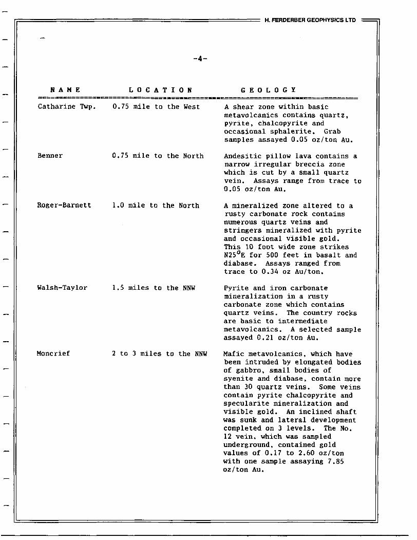
N A M E LOCATION
Catharine Twp. 0.75 mile to the West
Benner 0.75 mile to the North
Roger-Barnett 1.0 mile to the North
Walsh-Taylor 1.5 miles to the NNW
Moncrief 2 to 3 miles to the NNW
GEOLOGY
A shear zone within basic metavolcanics contains quartz, pyrite, chalcopyrite and occasional sphalerite. Grab samples assayed 0.05 oz/ton Au.
Andesitic pillow lava contains a narrow irregular breccia zone which is cut by a small quartz vein. Assays range from trace to 0.05 oz/ton Au.
A mineralized zone altered to a rusty carbonate rock contains numerous quartz veins and stringers mineralized with pyrite and occasional visible gold. This 10 foot wide zone strikes N250E for 500 feet in basalt and diabase. Assays ranged from trace to 0.34 oz Au/ton.
Pyrite and iron carbonate mineralization in a rusty carbonate zone which contains quartz veins. The country rocks are basic to intermediate metavolcanics. A selected sample assayed 0.21 oz/ton Au.
Mafic metavolcanics, which have been intruded by elongated bodies of gabbro, small bodies of syenite and diabase, contain more than 30 quartz veins. Some veins contain pyrite chalcopyrite and specularite mineralization and visible gold. An inclined shaft was sunk and lateral development completed on 3 levels. The No. 12 vein, which was sampled underground, contained gold values of 0.17 to 2.60 oz/ton with one sample assaying 7.85 oz/ton Au.
H. FERDERBER GEOPHYSICS LTD
-5-
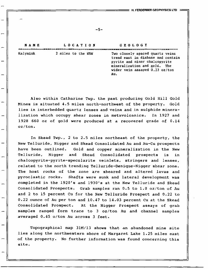
NAME LOCATION GEOLOGY
Kalyniuk 2 miles to the WNW Two closely spaced quartz veinstrend east in diabase and contain pyrite and minor chalcopyrite mineralization and gold. The wider vein assayed 0.23 oz/ton Au.
Also within Catharine Twp. the past producing Gold Hill Gold Mines is situated 4.5 miles north-northwest of the property. Gold
lies in interbedded quartz lenses and veins and in sulphide minera
lization which occupy shear zones in metavolcanics. In 1927 and
1928 660 oz of gold were produced at a recovered grade of 0.14 oz/ton.
In Skead Twp., 2 to 2.5 miles northeast of the property, the
New Telluride, Nigger and Skead Consolidated Au and Au-Cu prospects
have been outlined. Gold and copper mineralization in the New Telluride, Nigger and Skead Consolidated prospects is in
chalcopyrite-pyrite-specularite veinlets, stringers and lenses, related to the north trending Telluride-Denique-Nigger shear zone. The host rocks of the zone are sheared and altered lavas and pyroclastic rocks. Shafts were sunk and lateral development was
completed in the 1920's and 1930's at the New Telluride and Skead Consolidated Prospects. Grab samples ran 0.5 to 1.0 oz/ton of Au
and 2 to 15 percent Cu for the New Telluride Prospect and 0.22 to
0.22 ounce of Au per ton and 10.47 to 14.03 percent Cu at the Skead Consolidated Prospect. At the Nigger Prospect assays of grab
samples ranged form trace to 3 oz/ton Au and channel samples averaged 0.45 o /ton Au across 3 feet.
Topographical map 31M/13 shows that an abandoned mine site lies along the northwestern shore of Margaret Lake 1.25 miles east
of the property. No further information was found concerning this site .

H. FERDERBER GEOPHYSICS LTD
-6-
INSTRUMENTATION AND SURVEY METHODS
The survey was completed using a 1972 Cessna 172, fixed wing aircraft, call letters CF-EWK, owned and operated by H. Ferderber
Geophysics Ltd. The pillow and navigator/operator were M. Turcotte and D. Monastesse respectively, of Val d'Or and Vassan.
Magnetometer
The magnetometer used was a GEM Systems GSM-11, high
sensitivity airborne proton (Overhauser) magnetometer. The
instrument continuously measures the Earth's magnetic field at a
0.01 gamma sensitivity for l reading per second to 10 readings per
second at 0.1 gamma absolute accuracy. For this survey four readings per second were collected. The analog output is on 3 channels, from l to 10,000 gammas full scale.
VLF-EM System
A Herz Totem 2A VLF-EM System was used to measure the changes in the total field and in the vertical quadrature field on two frequencies simultaneously, with an accuracy of l *. The primary
transmitting station of Annapolis, Maryland (NSS), frequency 21.4 kHz was employed in the survey.
Radar Altimeter
The ground clearance was measured with a King 10/10 A radar
altimeter. The survey was flown at a mean clearance of 300 feet
with the altimeter producing an accuracy of 5% (15 feet) at this altitude.

H. FERDERBER GEOPHYSICS LTD
7
Tracking Camera and Video Centre
A RCA TC-200 colour video camera and Galaxy 200 video centre was used to record the flight path on standard VHS type video tapes. Manual fiducials were indicated on the picture frames for reference with digital printout. Flight path recovery was aided
using a Panasonic Colour Video Monitor-81300 and Video Cassette Recorder AG-2500.
Data Acquisition System
A Picodas Group Inc. PDAS 1100 data acquisition system featuring seven analog inputs with two frequency inputs and
external interfacing was used. A Termiflex Corp. ST/32 Keyboard
control unit and Sharp Corp. LCD display unit are connected to the data acquisition system. At present this system stores the
altimeter VLF-1 in-phase, VLF-1 quadrature, VLF-2 in-phase, VLF-2
quadrature, magnetic field (coarse), magnetic field (fine), and the fourth difference (noise), and fiducials on 3.5 inch floppy disk drive. The data is then printed out in digital and profile form.
The survey was conducted on lines oriented at 090 and 270
degrees, flown at an average aircraft altitude of 300 feet and a speed of approximately 90 miles per hour. Geophysical responses
were collected at data points spaced at 33 foot intervals along the
lines. The lines were spaced at 440 feet intervals. Navigation
was visual using airphoto mosaics, at a scale of one inch to 1320
feet, manual fiducials, and the flight path recovery system as references.
DATA PRESENTATION
Flight lines, fiducial points and geophysical responses were reproduced from the airphoto mosaics at a scale of one inch to 1320

H. FERDERBER GEOPHYSICS LTD
-8-
feet (1:15,840). The computer processing was performed utilizing the Geosoft Inc. 2-D Mapping System on an IBM compatible AGI
computer. Plotting was done on a Houston Instruments DMPL-62 plotter driven by both the Geosoft and the AutoCad software. The
outline of the claim block and claim map are shown on each map sheet.
The aeromagnetic data was corrected for diurnal variations by
using base lines as references. The data was then contoured at 20
gamma intervals and presented on Map MG-1.
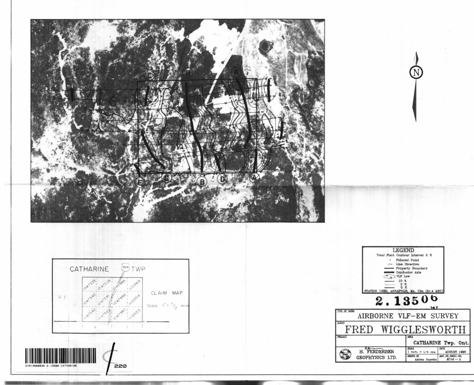
The VLF-EM was transferred from the Totem 2AG memory to profiled form. A base value was determined for the VLF-EM profiled
data. These values were used to correct for variations in transmitter strength and the corrected values were plotted on Map
EM-1. The positive values were contoured at intervals of 2%. The conductor axes were determined and labelled A, B, C, etc. No
priority was attached to the labelling system.
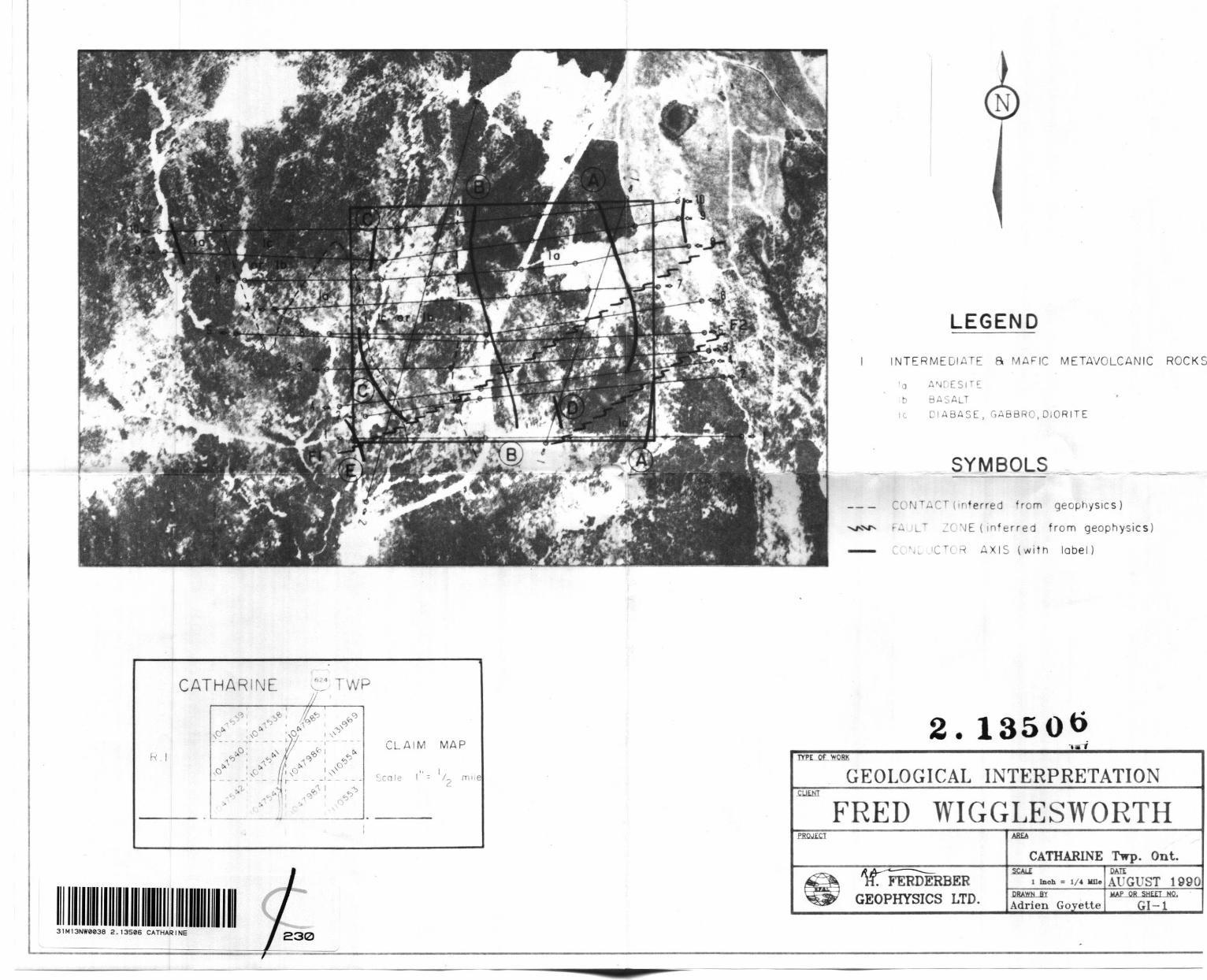
A geological interpretation of the magnetic data plus conductor axes are shown on Map GI-1.
SDRVEY RESDLTS AND INTERPRETATION
Magnetic Survey
The most prominent features delineated by the results of the
airborne magnetic survey are two series of south striking highs,
located across the western half of the Wigglesworth property and 0.25 miles west of the northwest corner of the claim group. These
highs exhibit magnetic values of 300 gammas above background and are probably caused by units of basalt, possibly containing zones of diabase or magnetite-pyrrhotite mineralization (see Map GI-1). The Hounslow gold occurrence lies in this high, in the southwestern corner of the property. The Benner, Roger-Barnett and Walsh-Taylor
H. FERDERBER GEOPHYSICS LTD
-9-
gold occurrences lie along strike of the basalt unit, north of the
property.
Over the remaining two thirds of the property the magnetic
values are lower and the relief is generally less than 100 gammas.
These areas, as defined by the positions of magnetic lows, appear
to be underlain by intermediate metavolcanic rocks (andesite).
Distortions and breaks in the magnetic isograds outline the
locations of two zones of deformation (faults FI and F2 ) . These
two fault zones strike west-southwest across the intermediate and
mafic metavolcanic rocks in the southern half of the claim group.
The Hounslow occurrence is situated near the west end of fault FI.
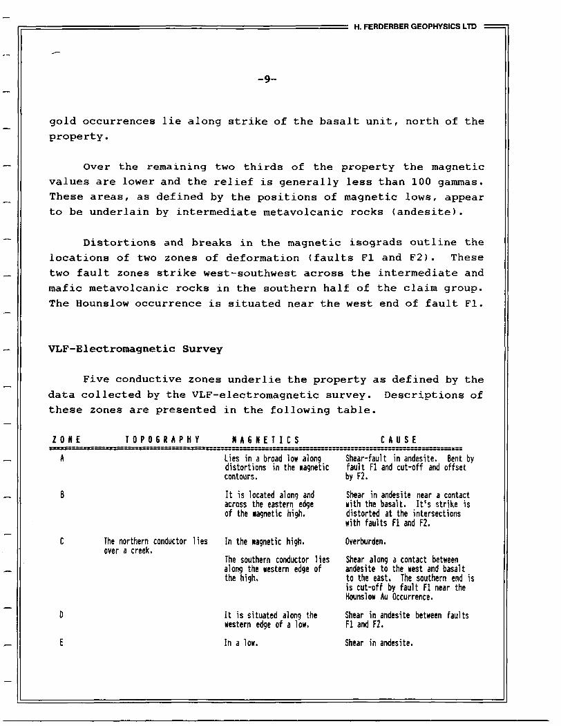
VLF-Electromagnetic Survey
Five conductive zones underlie the property as defined by the
data collected by the VLF-electromagnetic survey. Descriptions of
these zones are presented in the following table.
ZONE TOPOGRAPHY MAGNETICS CAUSE
The northern conductor over a creek.
Lies in a broad low along distortions in the Magnetic contours.
It is located along and across the eastern edge of the magnetic high.
lies In the Magnetic high.
The southern conductor lies along the western edge of the high.
It is situated along the western edge of a low.
In a low.
Shear-fault in andesite. Bent by fault FI and cut-off and offset by F2.
Shear in andesite near a contact with the basalt. It's strike is distorted at the intersections with faults FI and F2.
Overburden.
Shear along a contact between andesite to the west and basalt to the east. The southern end is is cut-off by fault FI near the Hounslow Au Occurrence.
Shear in andesite between faults FI and F2.
Shear in andesite.
H. FERDERBER GEOPHYSICS LTD
-10-
CONCLUSIONS AND RECOMMENDATIONS
The maps produced from the data collected by the airborne geophysical surveys were helpful in providing further information concerning the geology and structures underlying the Wigglesworth
property in Catharine Twp. and in defining the locations of 5 conductive zones on the claim group. Most of the property appears
to be underlain by intermediate metavolcanic rocks comprised of
andesite. A unit of basalt, possibly containing pyrrhotite- magnetic mineralization and/or diabase, strikes northward across
the western claims. Two west-southwest trending fault zones cut
across the metavolcanic rocks. The Hounslow gold occurrence is
thought to lie within the basalt, near fault FI in the southwestern corner of the claim group.
Of the 5 conductive zones delineated on the property, only the
northern conductor of zone C appears to be caused by conductive
overburden. The remaining conductors represent potential north
trending shear/fault zones, which may contain carbonate alteration,
quartz veining and/or sulphide mineralization. The best targets for potential gold deposition lies at the intersecitos of the west-
southwest striking fault zones and the conductive zones. The
southern conductor of zone C, trending north-northwest then north from the intersection of fault FI for 2000 feet, lies near known gold mineraliation in basalt and could represent an extension of
the Hounslow occurrence.
Further exploration work is warrented on the property. The
results of the airborne surveys should be confirmed and classified
by completing ground magnetic and horizontal loop-electromagnetic surveys over the claim group. Detailed geological mapping should
H. FERDERBER GEOPHYSICS LTD
-11-
be completed concentrating in the area of the Hounslow occurrence
and conductive zone C. If the results of this exploration proves
positive, the anomalous areas could be tested by stripping and/or
diamond drilling.
Respectfully submitted by,
H. FERDERBER GEOPHYSICS LTD.
R.A. Campbell, B.Se. Geologist
H. FERDERBER GEOPHYSICS LTD
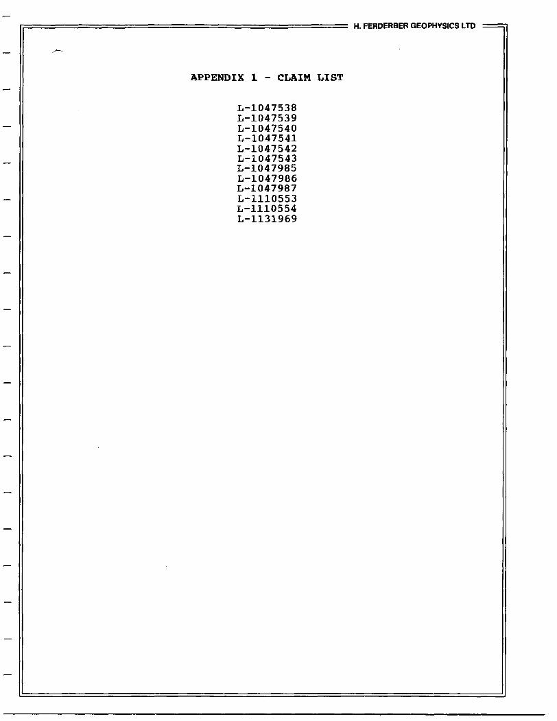
APPENDIX l - CLAIM LIST
L-1047538 L-1047539 L-1047540 L-1047541 L-1047542 L-1047543 L-1047985 L-1047986 L-1047987 L-1110553 L-1110554 L-1131969
Ministry ofNorthern Developmentand Mines
______r____ . _ __ TV
l DOCUMENT NO. Instructions MA/OAAQ.-JP/C' l -Please type or pnni
VVyUUO*""^7-3 l B-lor t" C~-,.~- T, * . ..:-. --.
03
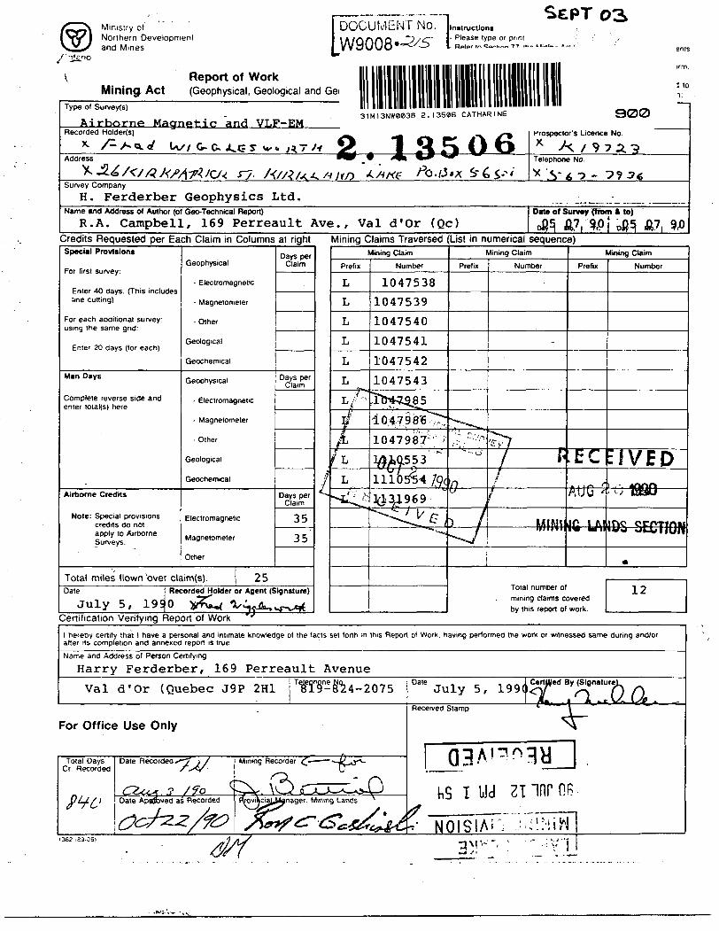
Report of Work Mining Act (Geophysical, Geological and Gei
Type of Surveys)
Airborne Magnetic and VLF~EM
i lo
31M13NW0838 2.13506 CATHARINE 300
Krospector's Licence No.
* A 7 9 72.Telephone No.
Survey Company
H. Ferderber Geophysics Ltd.Name end Address of Author (of Gee-Technical Report)
R.A. Campbell, 169 Perreault Ave., Val d'Or (Qc)Oat* of Survey (from A to)
A7,Credits Requested per Each Claim in Columns at right Mining Claims Traversed (List in numerical sequence)Special Provisions
For first survey:
Enter 40 days. (This includes line cutting)
For each additional survey: using the same grid:
Enter 20 days (lor each)
Man Days
Complete reverse side and enter total(s) here
Airborne Credits
Note: Special provisions credits do not apply to Airborne Surveys.
Geophysical
- Electromagnetic
- Magnetometer
- Other
Geological
Geochemical
Geophysical
- Electromagnetic
- Magnetometer
- Other
Geological
Geochemical
Electromagnetic
Magnetometer
Other
Days per Claim
Days per Claim
Days per Claim
35
35
Total miles flown over claim(s). 25Date Recorded Holder or Agent (Signature)
July 5, 1990 lSr?\ftW Vi-fiu, vr-l^
L
Certification Verifying Report of Work
Mining Claim
Prefix
L
L
L
L
L
L
/"
i/L
f L
L
^^f
Number
1047538
1047539
1047540
1047541
1047542
1047543
Jfr4-iS85
10.47986^:
1047987" 'i
MM553.
111&S54 #C
](13J.969"^"^^y v p
Mining Claim
Prefix
' ~~ .^' ' ' ̂
"" "- o
~
^4^J
Number
'^7f ^
4 —
Mining Claim
Prefix
EC
AU G 5
Jf5 1 All"" "'
1
Total number of mining claims covered by this report of work.
Number
EIVED! , ~ ASVlft, 1330
- wECTlON
*
12
1 hereby certify that 1 have a personal and intimate knowledge of the facts set forth m this Report of Work, having performed the work or witnessed same during and/or after its completion and annexed report is true
Name and Address of Person Certifying
Harry Ferderber, 169 Perreault Avenue
Val d'Or (Quebec J9P 2H1Dale , ^Julys.
ied
Received Stamp
For Office Use Only
Total Days Cr Recorded
Date Recorded ^" i X
,,^r .3 /7Q Date ApnJbved as Recorded
Mining Recorder
s^A ovikciaLjUanager. Mining Lands * KS i ziinroB
*- NOISiAi3M V". ;

Ministry ofNorthern Developmentand Mines
Geophysical-Geological-Geochemical Technical Data Statement
)ntario 2.l TO BE ATTACHED AS AN APPENDIX TO TECHNICAL REPORTj FACTS SHOWN HERE NEED NOT BE REPEATED IN REPORTj TECHNICAL REPORT MUST CONTAIN INTERPRETATION, CONCLUSIONS ETC.;
Type of Survey(s).
Township or Area.
Claim Holder(s)
Airborne MAqnetic and VLF-ElectromagneticCatharine
Fred Wigglesworth
H. Ferderber Geophysics Ltd.Survey Company
Author of Report R .A. CampbellAddress of A..fhm- 1 69 Perreault Av. , Val d'Or (Qc)
Covering Dates of Survey July 5, 1990(linecutting to office)
Total Miles of Line &XX F lown: 16.33
l SPECIAL PROVISIONS CREDITS REQUESTED
x l
j ENTER 40 days (includes line cutting) for first survey.ENTER 20 days for each additional survey using same grid.
Geophysical—Electromagnetic.
—Magnetometer_—Radiometric———Other—————-
DAYS per claim
Geological.
Geochemical.
AIRBORNE CREDITS (Special provision credits do not apply to airborne surveys)
3 8 . 8{?W tromagnrtir 38.8 Radiometric ______ (enter days per claim)
HATR- August 29/90 Sir.NATIIRF.;Author of Report or Agent
Res. Geol.. .Qualifications A*
Previous Surveys File No. Type Date Claim Holder
MINING CLAIMS TRAVERSED List numerically
L-1047538
L-1047540
L-1047541
L-1047542
L-1047543
L-1047985
L-1047986
L-1047987
L-1110553
L-1110554
L-1131969
(number)
S
TOTAL CLAIMS. 12
837 (85/12)
SELF ?QT:r.:;TIAL
Instrument.————————————————————————————————————————— Range. Survey Method ——————————————————————————————————————————————
Corrections made.
RADIOMETRIC
Instrument.Values measured.
Energy windows (levels)——-—-——^^-—^—,.^^—-.^^^^^^^^^^^^^^^^—— Height of instrument____________________________Background Count.Size of detector————-——^^————^^—^————.——^^^^^^^^^^^^^^^^^—
Overburden ——^^—————^^^————^——^—.^^——.^^^^^^^^——————^——(type, depth — include outcrop map)
OTHERS (SEISMIC. DRILL WELL LOGGING ETC.)
Type of survey————————————————————————— Instrument ——————————————————————————— Accuracy———————^^^^^———————^——^^—-^—Parameters measured.
Additional information (for understanding results).
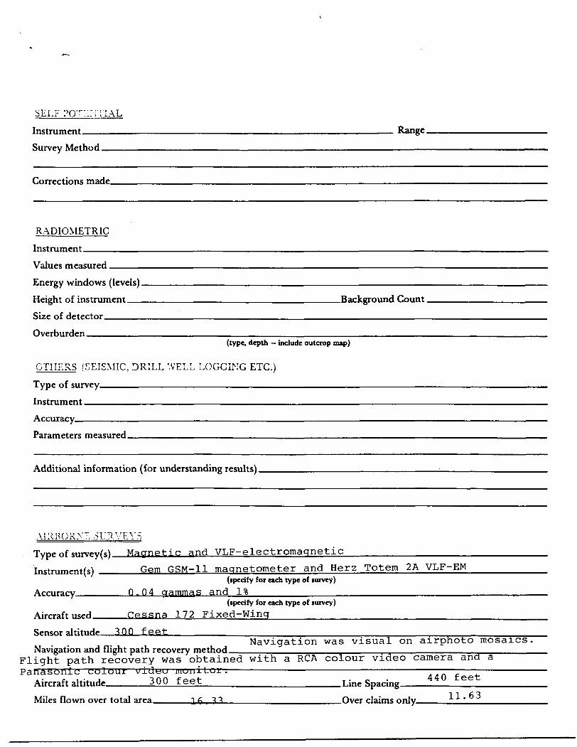
AIRBORNE -.SURVEYSType of giirvpy(s) Magnetic and VLF-electromagnetic———————.^^—^—-——Instrument(s) _____Gem GSM-11 magnetometer and Herz Totem 2A VLF-EM
(specify for each type of survey)
Accuracy_______Q. O4 gammas and l%(specify for each type of survey)
Aircraft used ____Cessna 172 Fixed-Wing^^^^-———
Sensor altitude 3 QQ feetNavigation was visual on airphoto mosaics,
Navigation and flight path recovery method.Flight path recovery was obtained with a RCA colour video camera and aPanasonic colour vj.ut:u mOui Loir. ~ ~ "~
Aircraft altitude_____300 feet__________________Line sr^;nE 4 4U t eet:
Miles flown over total area_____16 - ??________________Over claims only____2-Ll____
4\1&&
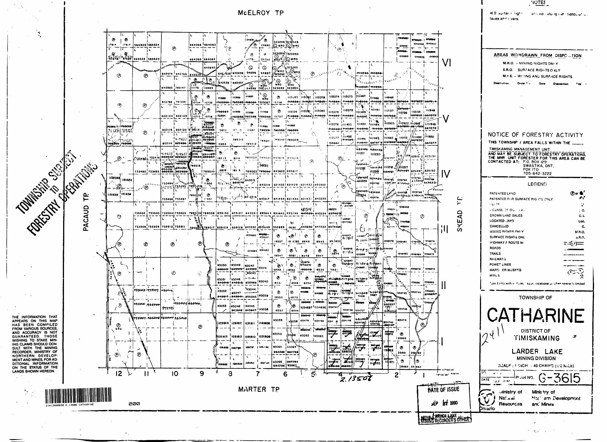
THE INFORMATION THAT APPEARS ON THIS MAP HAS BEEN COMPILED FROM VARIOUS SOURCES, AND ACCURACY IS NOT GUARANTEED. THOSE WISHING TO STAKE MIN ING CLAIMS SHOULD CON SULT WITH THE MINING RECORDER, MINISTRY OF NORTHERN DEVELOP MENT AND MINES, FOR AD DITIONAL INFORMATION ON THE STATUS OF THE LANDS SHOWN HEREON.
MCELROY TP
^
17*17
C!)
5*53251565524
nan*
... J
735492! 73)493
733494 L'' 11*^:^1713495 1789'
733496J733497
l733504)733505 .T89o((o6l T8 — *?A —l ——L : L L \U l
®
L 11 i664066 '664063L lT ~ ""
ll
664065 .'664064
S 24(91
24690523048 !ft23J]o49
'L
602104 802109
^rtt^MAA^
tSSST
182
njf.ua i Q ve it V o'rcTjici rrj
642^35' 642836 l 54696 | 54697r/" fi—rr"TO;-(642538 l 64*537
l l
1111989 l ""•9*
k111088
HU964
1111*87! L fDl MRO
k l 523057 |^706 ' ? IA*18J J'l^-~!L"TT~ " k ;l1111)86 l " II9W
ZJLTlViXiV l-*^*\* ****" w tj v w i w y y\f
V IIII96O4' O 098* |7*
L"* "Z "' li
789.013 769011JB90I2 j
,L ItV
0214 789004 ' 7 89001
1 "* i L l L
I91I5\ i 162 t
843214:L ^'•"T'^hT" T'S/^.V 1 ^ 8 2̂ ' 6 ! 6432,7
Q i
523055 1523054
(P) )2 l 1112078
III2I0415707^7-1^69 j*
IH2080 | 7I4COS
1112074 l II12073
l 1112073 l
ILII12079
-H4663'l 714863
IIIIMI l HUM?
;A^A* ' 7AA44
'"9010 l 789009
H'2076 ||||I493
n
1112077
693620 893617 |T—,U ——
l821433) 821429T-rL——
l 6?I434| 821430
[82I432J89380I-- j-—~-
821431 j 643335
r1659130 859127 643331 j 693644 895843 j 893F9* 6-43989 j 643334
Vl
839129 ] 859128 '843332 J89Jb45———' . "^ TC.~T — —
l L
l to .'- "i332869 M8C8I y84**W j 643333r- —|v: - L -{c
12 10 9
l U11492 l T 14 50 frl S
l )III487 l HII486
""490 l|IN4fll.1-
1,1,491J Q v * O r "~i"O
IIII22I | |||220
mi
l ^^fc f-/** O r W ~|F "J
222 ,t,w^M,^ 7 iinefs-^ ^,i y— -
I^^Viog^
/A
11223
-f^r - -rr^vt*' |mT224 l i
T^ [.0^976.-L.- . ^1,1 ^———J
^7*1047991 962371 ' "' -
89f 4O SI
i: //^
6 r
- — . t049911 itl—..
1049*10
H48407
L
JIII2136
*te*r- l w***'049906. '0^9907
'04*90^ .04*901
1110923 uill949
VI
V
616397
|r/ ,616/, 396
IIII2I8 ^//III2I7
IO497OT 104*764
*~/.
66707^
^ l 62515-Z i 625151
625149 '^Jfj 5̂
'^^J'0^66~
1049766
IV
1046498
k)46478 JI048460r** * *** ^"* ** -* - —
\.
j 1046463 j I046484||096676'
l1096676 ' 1096879
-^-1- ————f-^-. J,^--
H557 18 0(62! 894S 8945
. "^^'"h— l. v-4l' 54,Ll^L i L T HL~ ^ i/A T , T
-L8-!?' j- / I894e ! '*254- ^- K-
'"3062 IIH3063 —— -J.
1*3065 1113064
!**??- —— —K ——
I0tl60t i 10917ft
1041842 l 14X78^
L:
4T*88 O*'
31M13NW0038 2.13506 CATHARINE 200
bAf E OF ISSUE^EP W 1990
4(0 auifar .* 'igf la*es arf t vers.
i. w* -*
AREAS VVn HpRAW/S^FRpM OISPC ,, TION
M.R.O. - MINING MIGHTS ONI Y
S.R.O. SURr ACE RIGHTS O ^LY
M.* S. ~ ,Mr:iNG ANO SURFACE RIGHTS
Description Ord*r") Oat* Oitpotitton ril6 '
NOTICE OF FORESTRY ACTIVITYTHIS TOWNSHIP l AREA FALLS WITHIN THE ———.
TIMISKAMING MANAGEMENT UNIT AN(f MAY~BE~SU8JECT TO?OrlESTRY~OPERATidNS. THE MNR UNIT FORESTER FOR THIS AREA CAN BE CONTACTED AT: P.O. BOX 129
SWASTIKA, ONT.POK ITO705-642-3222
LEGEND
PATENTED USD ©Of Q*
PATENTED Fi .R SURFACE RIG ITS ONLY * *' t, ^ 'J
k iCcNSL :F Oov r/*.,; . O.CROWN LANP SALES C. 5.LOCATED ..ANO Loc.CANCELLtD C.MINING PI*?HTS owl v M.R.O.
SURFACCniGHTSONL a.R.O.
H'GHWAY f- ROUTE N( ^.Z^Vp^
ROADS t '
TRAILS ..._____.
RAiLWAYS ^.^ ̂-M—N.
POWEr LINES ^.,——..-^-MARS; OR MJSK^Q ,x-x.*- T*C -* -^xMINcS ^.
•jsf d on!/ with s' -.,,iei taor. locations ji .vh*'* *p*c6 l:s limited
TOWNSHIP OF
CATHADISTRICT OF
TIMISKAMING
LARDER LAKEMINING DIVISION
: 1 INCH - 40 W2 M.Lfc)on.
DATEAN NO.
-JI.Y G -3615"^* f ministry of r:, l Nat^iaiM,-/ Resources
)niario
Mink *ry ofk?.o?' em Oevelopmontanc' Mine*

CAT
K.I
MARINE b^TWP
^ ^ \C^ !x^
- — - - - - ~~Hr~ — - - - .-..
CLAIM MAP
^ c n 1 e 1 ' - /p . m i . e
31M13NW003B 2.13506 CATHARINErl 210
N.
LEGEND
TOTAL FBU) CONTUR INTDffAL - 90 QAIO1A8
3 Fiducial Point ~> line Direction
Magnetic Low
100 gamma* 80
2.13506TYPE Of
.CLfENI
WORK
MAGNETIC SURVEY
FRED WIGGLESWORTHPfffiJECl
^ ^
Sk fi^FERI)ERBERW GEOPHYSICS LTD.
AREA
CATHARINE Twp. Ont.5CALL
I ir.t;K s 1/4 nil*
MAWji. ir Adrien Goyette
iATtAUGUST 1990MAP OR SHEET 40.
MG. 1
CATHARINE x/
CLAIM MAP
Scale 1 - / mile
LEGENDTotal Field Contour Interval 2 X
o Fiducial Point O Line Direction
^^— Property Boundary ^•w Conductor Axil C^^VLF Loir———— 10 X———— Z X—— o x
STATION USED. ANNAPOUS. MA. USA (21.4 kHZ)
2. 1350*1AIRBORNE VLF-EM SURVEY
GHENT
FRED WIGGLESWORTHPROJECT
^gj^ H/^EM' "' ^v
\t^3TJ^T5y |*j-^^f^ J^ f*
^^ GEOPHYSICS LTD.
AREA
CATHARINE Twp. Ont.SCALE 1 inch. - 1/4 ruleDRAWN BY
Adrian Goyett*
BUS AUGUST 1990
MAP OB SHEET MO.
EM— 1
CAT MARINE C;TWP/xX X:/5 ; X
•^ -\^ /f i,^ i # o^ 1 e,111 /r o"1 i \x
1 * '.o0" 1 r t1* .-' (;
* , * ^,
CLAIM MAP
Scale 1 ' - /? mi. e
BfPLfit.
iUEMT
LEGEND
INTERMEDIATE S MAFIC METAVOLCANIC ROCKS
'o ANDESITEb BASALT
ic DIABASE, GABBRO, D.ORITE
SYMBOLS
CON T ACT (interred from geophysics)
FA JL T ^C ME (inferred from geophysics
CONI LECTOR AXIS (with label)
2. 1350*)GEOLOGICAL INTERPRETATION
FRED WIGGLESWORTHEBfULCT
^FERDERBER GEOPHYSICS LTD.
ABEA
CATHARINE Twp. Ont.
l Inch = 1/4 IlUeDRAWN BY
Adrien Goyette
DAK
AUGUST 1990HAP OR SHEET NO.
GI-1
31M13NW0038 2.13586 CATHARINE eso