Embed Size (px)
Citation preview
GXP OpsView provides critical planning and response support for:
» Active assailants, terrorist attacks, and hostage situations
» Emergency management and disaster relief
» Wildland firefighting and prevention
» Search and rescue operations
» Drug Interdiction and high-risk warrants
» Private security for corporate offices, industrial facilities, and events
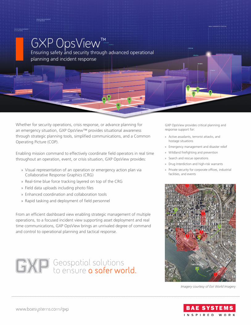
Whether for security operations, crisis response, or advance planning for an emergency situation, GXP OpsView™ provides situational awareness through strategic planning tools, simplified communications, and a Common Operating Picture (COP).
Enabling mission command to effectively coordinate field operators in real time throughout an operation, event, or crisis situation, GXP OpsView provides:
» Visual representation of an operation or emergency action plan via Collaborative Response Graphics (CRG)
» Real-time blue force tracking layered on top of the CRG
» Field data uploads including photo files
» Enhanced coordination and collaboration tools
» Rapid tasking and deployment of field personnel
From an efficient dashboard view enabling strategic management of multiple operations, to a focused incident view supporting asset deployment and real time communications, GXP OpsView brings an unrivaled degree of command and control to operational planning and tactical response.
Geospatial solutionsto ensure a safer world.
GXP OpsView™Ensuring safety and security through advanced operational planning and incident response
Imagery courtesy of Esri World Imagery
www.baesystems.com/gxp

Dashboard view for operations oversight
Providing a strategic view of your entire organization, the GXP OpsView Dashboard provides oversight into all active incidents in real time while providing access to historical incidents for reporting, review, forensics, and training.
» COP of all active incidents via list and map views
» Content overlays on the map view via standards-based data sharing
» Rapid identification of all responders and available resources
» Simplified communication with field personnel
» Strategic viewpoint for executing operational strategy across all activity
Incident Detail view for efficient response
The Incident Detail view allows users to drill down into a specific incident to see details regarding personnel, tasking, operation files and content, and communications.
» Multi-layered CRG
» Teaming tools for rapid execution of Incident Command best-practices
» Real-time tracking with bread crumbs for previous asset location
» Enterprise-wide sharing of incident data
» Uploads of field data (including photos)
Collaborative Response Graphics provide a common operating picture and an accessible visual representation of an emergency action plan for all response personnel including:
» Gridded Reference Graphics overlaid onto current site maps
» Precise measurements of distance and elevation, degree of slope, and line of sight
» Critical data including staging areas, evacuation zones, vantage points, hazards, and roadblocks
» Real-time tracking of response personnel via mobile devices
» Data-agnostic support for imagery registration and overlays onto the plan
Imagery courtesy of EagleView Technologies & Pictometry Intelligent Images
© 2017 BAE Systems. All Rights Reserved. ClearFlite, DataThruWay, GXP, GXP WebView, GXP Xplorer, Multiport, SOCET GXP, and SOCET SET are registered trademarks of BAE Systems. This document gives only a general description of the product(s) or service(s) offered by BAE Systems. From time to time, changes may be made in the products or conditions of supply. Approved for public release as of 04/12/2017; This document consists of general information that is not defined as controlled technical data under ITAR Part 120.10 or EAR Part 772. 20170331-09.
Australia and New ZealandTel +61 2 6160 [email protected]
Europe, Middle East, and AfricaTel +44 1223 370 022 [email protected]
AmericasTel 800 316 [email protected]
AsiaTel +603 2191 [email protected]