Embed Size (px)
Citation preview

Prepared forThe Colorado Nonpoint Source Task Force
Prepared byWright Water Engineers, Inc.
andDenver Regional Council of Governments
December 1996
Guidelines for Water Quality Enhancementat Golf Courses Through the Use of
Best Management Practices

Guidelines for Water Quality Enhancement at Golf Courses
Through the Use of Best Management Practices
Prepared for
the Colorado Nonpoint Source Task Force
Prepared by
Wright Water Engineers, Inc.
and
Denver Regional Council of Governments
December 26, 1996

Page i
TABLE OF CONTENTS
ACKNOWLEDGMENTS.............................................................................................................................ii INTRODUCTION.........................................................................................................................................1 PROJECT DESCRIPTION ...........................................................................................................................1 BEST MANAGEMENT PRACTICE DESCRIPTIONS..............................................................................8
Practices for Consideration During Design of Golf Course...................................................... 8 1. Pre-design Natural Resources Inventory and Evaluation........................................................8 2. Pre-design Planning and Golf Superintendent or Manager Design Input ...............................9 3. Identify Applicable Source Controls.......................................................................................9 4. Special Golf Course Drainage Design Considerations ...........................................................9 5. Wet Retention Ponds and Dry Detention Ponds ...................................................................10 6. Edge Treatment Along Ponds and Waterways......................................................................11 7. Grass Buffer Strips ................................................................................................................11 8. Grass-Lined Swales ...............................................................................................................12 9. Off-site Velocity Control Practices .......................................................................................12 10. Stream Crossing Design.....................................................................................................13 11. Man-made Wetlands ..........................................................................................................13 12. Conservation Easements ....................................................................................................14 13. Incorporation of Wildlife Habitat Features .......................................................................14 14. Advanced Irrigation Design...............................................................................................15
Construction BMPs ................................................................................................................. 17 15. Erosion and Sediment Control...........................................................................................17 16. Minimize Disturbance of Areas Designated for Native Species .......................................18 17. Re-seeding with Desirable Golf Course Mixes .................................................................18 18. Topsoil Preservation ..........................................................................................................18
Maintenance BMPs ................................................................................................................. 20 19. Integrated Pest Management and Use of Biological Treatments.......................................20 20. Irrigation Management.......................................................................................................22 21. Proper Use of Turf Grass Fertilizers..................................................................................23 22. Landscape and Vegetative Practices..................................................................................24 23. Turf Management Plan ......................................................................................................25 24. Golf Course Lake Management .........................................................................................25 25. Source Controls/Spill Prevention ......................................................................................26 26. Monitoring .........................................................................................................................26 27. Record Keeping .................................................................................................................27 28. Regular Maintenance .........................................................................................................28
Case Study: Maroon Creek Club Golf Course, Aspen, Colorado..............................................................29 REFERENCES............................................................................................................................................31
APPENDICES
APPENDIX A: EROSION AND SEDIMENT CONTROL PRACTICES APPENDIX B: INVENTORY OF POTENTIAL REGULATORY REQUIREMENTS

Page ii
ACKNOWLEDGMENTS
This report has been prepared with the input of many stakeholders in the golf course industry.
We would like to thank the following individuals who have participated in the golf course BMP workshops:
Guy Auxer, G.H. Auxer and Associates Craig Belcher, Keystone Ranch Golf Course Andy Bush, Redstone Development Services Bonnie Christenson, Carruth Sutton Development Corporation Rod Conrad, Thorn Creek Golf Course Steve Corniellier, Keystone Ranch Golf Course Whitney Cranshaw, Colorado State University Bob Kelly, Redstone Development Services Tony Koski, Colorado State University Wade Leasure, Applewood Golf Course Larry Perotti, L.L. Johnson Distributing Company Monte Stevinson, Indian Peaks Golf Course Don Tolson, Fox Hollow Golf Course Reagan Waskon, Colorado State University�Cooperative Extension Layne Wyatt, Northwest Colorado Council of Governments Mitch Yergert, Colorado Department of Agriculture
We would also like to thank the following people for their input:
Elisabeth Benjamin, Wright Water Engineers, Inc. Dave Brown, AMOCO Corporation Jane Clary, Wright Water Engineers, Inc. Russ Clayshulte, Denver Regional Council of Governments Michael Hurdzan, Michael Hurdzan Design Jonathan Jones, Wright Water Engineers, Inc. Dwight Kimsey, Wright Water Engineers, Inc. Wayne Lorenz, Wright Water Engineers, Inc. Chad Ritterbusch, American Society of Golf Course Architects

Page 1
INTRODUCTION
Water management is an important consideration for the planning, design, construction, and operation of a golf course. The development of a golf course can affect the hydrologic and water quality characteristics of an area compared to the undeveloped or previous site conditions. The historic stormwater patterns and quantity can be changed through golf course development to impact habitat, groundwater, soil conditions, and other aspects. The surface and groundwater quality can also be changed by the different practices used on a golf course. The purpose of this document is to provide guidelines to the golf industry on best management practices (BMPs) which help to minimize potential adverse impacts associated with golf courses. If these relatively straight-forward, proven BMPs are implemented, golf courses can be designed and operated to not only minimize impacts to the environment but also enhance the environment.
The Colorado Nonpoint Source Task Force is a voluntary advisory group to the Water Quality Control Division (WQCD) of the Colorado Department of Public Health and Environment (CDPHE). The Urban and Construction Subcommittee of the Nonpoint Source Task Force updated the urban and construction portion of the Colorado Nonpoint Management Program guidance document (WQCD 1996), identifying the need for project or type-specific water quality BMPs. Golf courses were identified as an industry which needs to employ BMPs to protect water and environmental quality.
Some of the key water quality improvement or prevention issues associated with golf course design, construction and maintenance include:
• ongoing conflict between the public and the golf course industry over environmental issues related to water resources degradation;
• a lack of customized BMPs appropriate for western states for use in design and operation of golf courses;
• the need for fundamental industry requirements for prevention of water quality or environmental degradation; and
• past unsuccessful public-private partnerships due to communication problems.
PROJECT DESCRIPTION
The goal of this project was to research, compile and customize a set of guidelines for potential golf course structural and nonstructural BMPs appropriate for design, construction and maintenance of golf courses. The BMPs were limited to those directly or indirectly influencing water quality. In addition, this report is not intended to serve as a comprehensive detailed manual for BMPs; instead, it provides guidelines that golf course managers should be aware of and references which can be obtained for more detail. This report contains the following:
• a summary of key BMPs related to water quality for implementation at golf courses,

Page 2
• references which managers can obtain for additional detail on given BMPs,
• an easy-reference summary table of BMPs according to design, construction and maintenance phases,
• a case study of the Maroon Creek Club golf course in Aspen, Colorado, which has implemented many of the BMPs identified in the guidelines contained in this report,
• an appendix of erosion and sediment control practices (Appendix A), and
• an appendix of regulatory considerations (Appendix B).
Stakeholders participating in the project include the American Society of Golf Course Architects, metro golf course owners and superintendents, environmental coalitions, various consultants, and state and federal governmental agencies. These stakeholders provided input on what potential BMPs they perceived as effective, what modifications to BMPs may be necessary, and what practices do not work with golf course design.
EVALUATION AND MONITORING PLAN
An evaluation questionnaire is attached to each copy of the BMP Guidelines report. The questionnaire will be used to evaluate the guidelines in this report as an educational tool. This survey will be used to assess the utility of the guidelines and the likelihood of following recommended practices. The survey will also request feedback on the ease of recommended BMP design and implementation, request suggestions for additional modifications, and assess level of interest in water quality monitoring for effectiveness of BMPs. The Colorado Nonpoint Source Task Force will then use this information to decide whether or not to pursue additional project- or type-specific BMP manuals for inclusion in their management program.
An article on the project, a notice of availability of the report and a fact sheet will be sent to the EPA�s Nonpoint Source News-Notes, The Colorado Conservator, DRCOG's In The Region Today newsletter, Urban Drainage and Flood Control District's (UDFCD�s) Flood Hazard News newsletter, Special Districts Association�s newsletter, Colorado Water Resources Research Institute�s Colorado Water newsletter, Home Builders Association of Metro Denver�s Home Builder magazine, Public Works Journal, Rocky Mountain section of the Water and Environment Federation, other councils of government in Colorado (Northwest Colorado Council of Governments, Pikes Peak Council of Governments and Pueblo Council of Governments), North Front Range Water Quality Planning Association, members of the golf industry, Natural Resource Conservation Service, members of the Colorado Nonpoint Source Task Force and the Urban and Construction Subcommittee, CSU Extension Service and county agents, and other nonpoint source and/or stormwater management organizations in neighboring states. The Subcommittee and the American Society of Golf Course Architects will distribute the guidelines on an ongoing basis, if funding can be secured for printing cost and if there is sufficient interest from the industry.

Page 3
GOLF COURSE BMPS
As previously mentioned, if golf courses are properly designed, constructed and operated, they are compatible with a healthy environment. Environmentally-friendly golf course operation uses BMPs to minimize adverse impacts to water quality. Table 1 summarizes a set of BMPs recommended for consideration in the design, construction and maintenance of golf courses. Many of these practices are adapted from the standard practices already identified as applicable for Colorado in the Urban and Construction Management Program (WQCD 1996), the Colorado Nonpoint Source Management Program, and by the UDFCD. More detail may be found on specific practices in the literature listed in the reference section of this report. In addition, the brief descriptions of the BMPs in Table 1 are expanded in the remaining text of this report. Some BMPs are relatively straight forward and require little additional explanation, while other BMPs are multifaceted and require more detailed description. For this reason, the level of detail associated with each BMP description varies significantly. Similarly, for some simplistic BMPs, no additional references are listed, while multiple references may be listed for more complex BMPs such as Integrated Pest Management (IPM). Finally, it is important to note that while most golf courses have some basic similarities, each golf course is also unique. Ultimately, golf course superintendents should apply their knowledge and experience to most effectively implement this �toolbox� of BMPs based on the site-specific conditions at their courses.
Table 1 Recommended Best Management Practices
BMP Considerations DESIGN 1. Pre-design Natural
Resources Inventory and Evaluation
• Provides basis for subsequent planning and design to avoid impacts to natural resources.
• Can include aquatic life, terrestrial life, riparian corridors, wetlands, open space, native species, endangered species, hydrology and drainage, soils, use-protection, classifications and standards, irrigation, stormwater, groundwater, water rights, water sources, geology, geomorphology, topography, etc.
2. Pre-design Planning and Golf Superintendent Design Input
• Identification and evaluation of on-site information provides design criteria to solve existing or perceived environmental problems.
• Involvement of the proposed superintendent or manager in the early design phases can lead to a more functional system design.
• The proposed superintendent should be requested to review the water resources and natural resource inventories and provide recommendations to be incorporated into the design phases.
3. Identify Applicable Source Controls
• Early in the golf course design stage it should be recognized that the single most effective BMP is the broad category of source controls related to pesticide and fertilizer usage. Strictly limiting their use and using appropriate types for site conditions on a �management unit� basis under an Integrated Pest Management (IPM) strategy helps to reduce the potential for water quality problems.
• BMPs 19 through 25 are specific source controls listed under the category of �maintenance BMPs� because of their ongoing practice during golf course operation; however, these should be considered early in the design process. See these BMPs for more detail.

Page 4
4. Drainage Design • Use �natural� drainage practices including preservation of natural drainages, wetlands, ponds, etc.
• Maintain wide undisturbed riparian (stream) corridors.
• Avoid flow concentration on-site and to adjacent hydrologically connected areas.
• Golf course grading should maximize infiltration in the large available pervious areas, thereby promoting removal of runoff from playing surfaces and minimizing drainage problems on adjacent hydraulically connected areas.
• Reverse-grading should be used to limit direct discharges into wetlands and streams where necessary.
• Optimized drainage designs should not result in water quality degradation. Many independent studies indicate that well-maintained turf produces little runoff.
5. Retention Ponds (Wet Ponds) and Detention Basins (Dry Ponds)
• Retention Pond (Wet Pond): base flow is necessary to maintain a permanent pool; capture volume must be emptied over an extended period (usually over 24 hours); embankment-spillway-outlet system must be designed to prevent failure; ponds should be designed as part of the course water features; and the ponds can incorporate a wide variety of water quality control features.
• Detention Basins (Dry Ponds): outlet is designed to extend the emptying time of the basin's capture volume; embankment-spillway-outlet system must be designed to prevent failure; and capture volume is emptied over as long of a time period as feasible, usually over 24 hours.
6. Edge Treatment Along Ponds, Waterways, Riparian Corridors and Wetlands
(Buffer zones from course to water feature)
• Edge protection practices can be part of the playing course and help to limit erosion problems.
• Edge treatments should consider the overall hazard value intended in the design of the hole.
• Buffer strip edges provide water quality protection and stormwater management benefits.
• Landscaping practices can be used to establish edges to enhance and protect water quality.
7. Grass Buffer Strips • The green space of a golf course can act as a buffer strip or open space to separate the development from environmentally sensitive areas.
• Uniform, dense grass buffer strips designed for sheet-flow conditions can treat return flows or natural runoff, improve water quality and limit the quantity of runoff.
• Buffer strips help to protect wetland and sensitive areas from fertilizer and pesticide contamination.
• Course design should explore making maximum use of fairways and �near roughs� to function as buffers.
8. Grass-Lined Swales • Swales can help minimize directly connected impervious areas, decrease runoff peaks, volumes and pollutant loads, and control drainage patterns.
• To maximize water quality improvement, sheet-flow conditions should be maintained across a uniformly graded, irrigated, dense grass cover strip.
• Swales should be designed to minimize runoff detention times and not �pond� water.
9. Off-site Velocity Controls
• Structural BMPs which control runoff velocities may be required in drainages at the boundaries of the course or within drainages on the course. Examples include drop structures and other energy dissipaters. These BMPs help to control erosion and water quality problems associated with sediment loading.

Page 5
10. Stream Crossing Design
• Stream crossings should be minimized.
• Required stream crossings should minimize impact to riparian corridors. (i.e., wide, free-spanning bridges)
11. Man-made Wetlands • Can be built as a wetland basin or set into a drainageway to form a wetland bottom channel.
• Requires appropriate hydraulic conditions to maintain wetland vegetation.
• Pollutant removal efficiencies of man-made wetlands can vary significantly.
• Design factors should include influent concentrations, hydrology, soils, climate, vegetative type, growth zonation, maintenance and harvesting.
12. Conservation Easements
• Preserve tracts for wildlife habitat and wetlands within development projects in environmentally sensitive areas.
• Involve deeds to a charitable trust or environmental organization to maintain natural land or water areas, but does not surrender property title. Rather, it gives rights to an organization to maintain the land in an undeveloped, natural state.
• Benefits include public recognition, and in some cases, tax and liability reduction.
• Land usage restrictions must be documented by land owner in a written agreement.
• Violation of agreement can be legally stopped by grantee.
• Good example of a cooperative development strategy.
13. Incorporation of Wildlife Habitat Features
• Golf courses can provide diverse habitat for wildlife.
• Use the resource inventories to identify important species which may need protection or will be a part of the finished course. (Also identify pest species such as geese and ground squirrels.)
• Accommodating these species in the design phases can help reduce conflict with the environmental community and enable better management of the species during operation of the course.
• Guidelines are available from the Audubon Cooperative Sanctuary Program for Golf Courses (established by the International Audubon Society and The United State Golf Association). Members of the American Society of Golf Course Architects work to design golf courses within the guidelines established by the Sanctuary Program, the Cooperative Sanctuary System (CSS).
14. Advanced Irrigation Design
• Computer-controlled irrigation systems can be used to reduce surface water runoff and groundwater recharge, thereby reducing the movement of fertilizer and pesticides. Water application rates correspond to consumptive use requirements.
• Return flow reuse, stormwater reuse and use of treated wastewater effluent for irrigation should be used when environmentally, legally (water rights) and agronomically feasible.
• Recycled water must meet all applicable standards and not pose a health risk.
• Drainage system designs are influenced by the selected reuse system.
Page 6
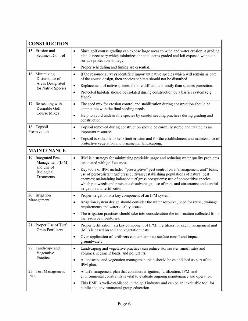
CONSTRUCTION 15. Erosion and
Sediment Control • Since golf course grading can expose large areas to wind and water erosion, a grading
plan is necessary which minimizes the total acres graded and left exposed without a surface protection strategy.
• Proper scheduling and timing are essential.
16. Minimizing Disturbance of Areas Designated for Native Species
• If the resource surveys identified important native species which will remain as part of the course design, then species habitats should not be disturbed.
• Replacement of native species is more difficult and costly than species protection.
• Protected habitats should be isolated during construction by a barrier system (e.g. fence).
17. Re-seeding with Desirable Golf Course Mixes
• The seed mix for erosion control and stabilization during construction should be compatible with the final seeding needs.
• Help to avoid undesirable species by careful seeding practices during grading and construction.
18. Topsoil Preservation
• Topsoil removed during construction should be carefully stored and treated as an important resource.
• Topsoil is valuable to help limit erosion and for the establishment and maintenance of protective vegetation and ornamental landscaping.
MAINTENANCE 19. Integrated Pest
Management (IPM) and Use of Biological Treatments
• IPM is a strategy for minimizing pesticide usage and reducing water quality problems associated with golf courses.
• Key tools of IPM include: �prescriptive� pest control on a �management unit� basis; use of pest-resistant turf grass cultivars; establishing populations of natural pest enemies; maintaining balanced turf grass ecosystems; use of competitive species which put weeds and pests at a disadvantage; use of traps and attractants; and careful irrigation and fertilization.
20. Irrigation Management
• Proper irrigation is a key component of an IPM system.
• Irrigation system design should consider the water resource, need for reuse, drainage requirements and water quality issues.
• The irrigation practices should take into consideration the information collected from the resource inventories.
21. Proper Use of Turf Grass Fertilizers
• Proper fertilization is a key component of IPM. Fertilizer for each management unit (MU) is based on soil and vegetation tests.
• Over-application of fertilizers can contaminate surface runoff and impact groundwater.
22. Landscape and Vegetative Practices
• Landscaping and vegetative practices can reduce stormwater runoff rates and volumes, sediment loads, and pollutants.
• A landscape and vegetation management plan should be established as part of the IPM plan.
23. Turf Management Plan
• A turf management plan that considers irrigation, fertilization, IPM, and environmental constraints is vital to evaluate ongoing maintenance and operation.
• This BMP is well-established in the golf industry and can be an invaluable tool for public and environmental group education.

Page 7
24. Golf Course Lake Management
• Limit eutrophication by control of runoff from fertilized areas by measures such as buffer strips and reverse grading.
• Control eutrophication by in-lake management techniques.
• Maintain flow through ponds.
• Avoid sediment build-up.
25. Source/Spill Controls
• Proper storage and handling of pesticides, fertilizers, fuel, and other maintenance chemicals helps to reduce pollutant loading.
• Abide by Community-Right-to-Know and Material Safety Data Sheets (MSDS) requirements.
• Establish and follow Spill Prevention Control and Countermeasures (SPCC) Plans for maintenance facilities.
26. Monitoring • Monitoring is useful to identify strengths and weaknesses of existing golf course management. Results should be used to revise management strategies.
27. Record Keeping • Record keeping is important to document changes in turf quality, pest levels, and water quality.
• A computerized database or spreadsheet is recommended. 28. Regular Maintenance
• The best-designed BMPs will fail without regular maintenance.

Page 8
BEST MANAGEMENT PRACTICE DESCRIPTIONS
Practices for Consideration During Design of Golf Course
1. Pre-design Natural Resources Inventory and Evaluation
Prior to design of a golf course, natural resources inventories should be conducted to provide the basis for the subsequent planning and design. A summary of potentially applicable resource inventories is listed in An Environmental Approach to Golf Course Development (Love 1992). Resource management surveys or inventories can be divided into two categories: (1) the basic required surveys and (2) the special or environmental constraint surveys needed because of site-specific conditions.
The basic required surveys include:
• Physical Area Characterization: hydrologic features, drainage characteristics, floodplains, soils, extent of riparian corridors, presence of wetlands, wetland mitigation sites, adjacent open space;
• Environmental Characterization: aquatic and terrestrial life, important native species, endangered species, growth zonation, climatic conditions; determine the need for an environmental assessment or an environmental impact statement;
• Water Resources: water rights, irrigation, water sources, availability of wastewater service, wastewater reuse potential, stormwater reuse potential, return flow reuse potential;
• Water Quality: water quality classifications and standards, watershed protection efforts, control regulations, special permit requirements; should address surface water (streams, lakes, stormwater), and groundwater;
• Regulatory: local zoning; local, state and federal regulatory reviews; special use requirements; required permits (See Appendix B for a representative list of regulatory considerations);
• Institutional (public involvement): federal and state agencies, active local groups (their areas of interest or concern), involvement of special districts, counties or municipal governments; and
• Infrastructure: location and type of roads, utilities and other structures.
The types of special or environmental constraint surveys needed are dependent on site-specific conditions and can include the following general areas:
• Environmental Constraints: Faults, shrink and swell soils, shallow bedrock, boulders, groundwater recharge zones, preservation of viewscapes, fire hazard areas, sensitive wildlife areas, sensitive aquatic habitats, flyways, stormwater flood areas, mineral or resource

Page 9
extraction resources, previous contamination, preservation of open space, and historical and archaeological sites.
SELECTED REFERENCES
Balogh, James C. & Walker, William J. 1992. Golf Course Management & Construction Environmental Issues.
Brown, Dave. 1994. Environmental & Safety Compliance Manual for Golf Course Operations. May.
Love, William R. 1992. An Environmental Approach To Golf Course Development. March.
Natural Resources Conservation Service (NRCS) Soil Surveys.
2. Pre-design Planning and Golf Superintendent or Manager Design Input
Involvement of the proposed superintendent or manager in the early design phases can lead to a more functional system design. The proposed superintendent or manager should be requested to review and evaluate the water resources and resource inventories, surveys and other site information. Based on this review and the superintendent�s professional experience, fertilizers, pesticides and the types of pests likely to be present can be identified. This information can be used to design source controls, including the integrated pest management plan, irrigation design, and turf management plan. The superintendent should provide recommendations to be incorporated into the design phases, including design criteria for responsible solutions to existing or perceived environmental issues.
3. Identify Applicable Source Controls
Early in the golf course design stage it should be recognized that the single most effective BMP is the broad category of source controls related to pesticide and fertilizer usage. Strictly limiting their uses and using appropriate types for site conditions on a �management unit� basis under an Integrated Pest Management (IPM) strategy helps to reduce the potential for water quality problems. BMPs 19 through 25 are specific source controls listed under the category of �maintenance BMPs� because of their ongoing practice during golf course operation; however, these should be considered early in the design process. See these BMPs for more detail.
4. Special Golf Course Drainage Design Considerations
Golf course drainage should optimize the removal of runoff from playing surfaces, while not causing a drainage problem on adjacent hydrologically connected areas. Fortunately, golf courses provide large areas of turf available for infiltration of rainfall, which decreases the amount of runoff from playing surfaces. Optimized drainage designs should not result in water quality degradation. In fact, many studies show turf in good condition generates very little runoff. Specific considerations include the following:

Page 10
• Stormwater runoff should be directed away from sensitive areas (streams, shallow groundwater areas, wetlands, etc.) and into areas where ponding and infiltration can occur.
• Extensive roughs and natural (undisturbed) areas offer excellent stormwater management opportunities.
• BMPs should be both �structural� and �non-structural� in nature and should be �layered,� to provide redundancy.
• Greens and tees may need underdrains that are directed into areas suitable for storage and passive treatment. These underdrain systems help to protect groundwater from leachate.
• Runoff management from residential areas and clubhouses should be integrated with runoff control from the golf course itself. Specific features may include berms, vegetative strips, grease traps and other BMPs.
• Stormwater quantity and quality should be handled jointly.
• Reverse-grading of roughs and fairways away from ponds, wetlands, and streams on the course help to reduce the potential of algae and weed infestations in lakes.
• The overall drainage design should ensure that there is not an increase in the amount or velocity of off-site flows.
• Monitoring and maintenance should be emphasized, particularly receiving water monitoring for regulated parameters both upstream and downstream from the course.
SELECTED REFERENCES
Balogh, James C. & Walker, William J. 1992. Golf Course Management & Construction Environmental Issues.
5. Wet Retention Ponds and Dry Detention Ponds
Retention and detention ponds are useful to help control water quality degradation associated with stormwater pollutant loads and to slow flow velocity associated with stormwater. The UDFCD Drainage Criteria Manual provides more detail, including schematics of these features. Basic descriptions of retention and detention ponds follow.
Retention ponds have a permanent pool of water that is replaced with stormwater, in part or in total, during storm runoff events. Temporary detention is provided above this permanent pool to allow sedimentation. Retention ponds are designed to capture and detain a volume of runoff from frequently occurring storms. Retention ponds mix the influent water with the permanent pool water as the influent water rises above the permanent pool. The captured volume above the permanent pool is then released over an engineer-designed time frame (usually over 24 hours). Retention ponds require a dry-weather base flow or construction below the water table to

Page 11
maintain the permanent pool. They can be very effective in removing pollutants, and under the proper conditions, can satisfy multiple objectives, including aesthetic purposes. Retention ponds should be designed as part of the course water features.
Dry detention ponds are designed to totally empty after stormwater runoff ends. A drain time of at least 24 hours for the brim-full capture volume is recommended to remove a portion of fine particulate pollutants; however, most grass can withstand up to 3 days of flooding. Soluble pollutant removal can be somewhat enhanced by providing a small wetland marsh or ponding area in the basin's bottom to promote biological uptake. The basins are considered to be "dry" because they are designed to not have a significant permanent pool of water.
SELECTED REFERENCES
Urban Drainage and Flood Control District. Drainage Criteria Manual, Volume 3.
Urbonas, B.R. and P. Stahre, 1993. Stormwater Best Management Practices and Detention for Water Quality Drainage and CSO Management. Prentice Hall, Englewood Cliffs, NJ.
6. Edge Treatment Along Ponds and Waterways
Preservation of edges of natural vegetation along ponds and waterways can help minimize erosion problems, improve water quality by pollutant removal and provide wildlife habitat. Landscaping practices can be used to establish wetland edge treatments. Structural protection, isolation, and maintenance practices to avoid removal of edge treatment (e.g., mowing practices) should be used.
Edge treatments must consider the overall hazard value intended in the design of the hole. Playability, and thus speed of play, can be negatively affected in specific cases where the golfer may be outside of the marked hazard, or possibly even in the fairway, and not have a reasonable shot due to the height of plant materials in the buffer strip. On the fairway side of the hole, cattails and willows are typically too tall to allow a fair golf shot. Management practices and/or plant material selection must be such that playability is maintained as much as possible for golfers who are not inside the limits of the hazard.
Certain native species should not be established on the fairway side of the pond in areas where they will grow up to block a shot along the intended line of play. Design and planting solutions are available; for example: raising the fairway two feet at the pond edge and creating an emergent wetland shelf in the pond that can double as a safety shelf. At the same time, establish lower-growing wetland plants and discourage the growth of willows and cattails.
SELECTED REFERENCES
Leslie, Anne R. 1994. Handbook of Integrated Pest Management for Turf and Ornamentals.
7. Grass Buffer Strips
Grass buffer strips are uniformly graded and densely vegetated areas of irrigated turf grass or unirrigated native species. They require sheet flow to promote filtration, infiltration and settling

Page 12
to reduce runoff pollutants. Grass buffer strips differ from grass-lined swales in that they are designed to accommodate overland sheet flow rather than concentrated or channeled flow. They can be used to remove larger sediment particles from sheet flow runoff from impervious areas as well as fine particles (through the electrostatic attraction of the grass).
To the extent feasible, runoff should be evenly distributed across the width of the buffer strip via a suitable structure to achieve sheet-flow conditions. Grass buffers can also be combined with riparian zones in treating sheet flows and in stabilizing channel banks adjacent to major drainageways and receiving waters. Buffer strips can be interspersed with shrubs and trees that can take up nutrients and provide shading. In a semiarid climate, irrigation is usually required to maintain healthy and dense grass on the grass buffer strip to withstand runoff from impervious areas.
SELECTED REFERENCES
Balogh, James C. & Walker, William J. 1992. Golf Course Management & Construction Environmental Issues.
Urban Drainage and Flood Control District. Drainage Criteria Manual, Volume 3.
8. Grass-Lined Swales
Grass-lined swales are densely vegetated drainageways with low-pitched side slopes that collect and slowly convey runoff. Design of their longitudinal slope and cross-section size forces the flow to be slow and shallow, thereby facilitating sedimentation while limiting erosion. Berms or check dams should be installed perpendicular to the flow as needed to slow the flow down and to encourage settling and infiltration.
SELECTED REFERENCES
Urban Drainage and Flood Control District. Drainage Criteria Manual, Volume 3.
9. Off-site Velocity Control Practices
A well-managed and designed golf course can infiltrate the water generated by a large rainfall event (such as the 5-year storm) without any off-site discharge. Although an important function of golf course design is to maximize drainage away from play areas so the course is not unplayable for long time periods, accelerated off-site drainage is not necessarily a significant problem if infiltration and grading are appropriately designed. However, in some cases structural controls may also be needed to control off-site velocities and potential erosion associated with these flows. These structures may be required in drainages at the boundaries of the course or within drainages on the course. Examples of velocity control structures include drop structures, retention and detention ponds. A regular maintenance program should be established to make sure that culverts, drain inlets, energy dissipaters, etc., are free from debris and in good condition.

Page 13
10. Stream Crossing Design
Crossings of natural drainage features should be taken into account with golf course design. Specific considerations include the following:
• Design fairways to reduce the number of stream crossings.
• Where course design indicates a need for stream crossings, orient fairways perpendicular to streams to the extent possible to minimize the area of disturbance.
• Design �landing areas� away from creeks and preserve riparian buffers.
• Limit perpendicular fairway crossings and mitigate potential stream impacts when these crossings are unavoidable.
• Restore and enhance riparian vegetation, especially in previously degraded habitat areas.
• Use surface drainage designs and vegetated buffer strips of sufficient width to mitigate impacts to riparian corridors and other significant habitat areas from runoff from managed turf grass areas, paved areas, and other course facilities.
• Design bridges to minimize alteration of the stream environment (i.e., free-span designs).
SELECTED REFERENCES
Santa Clara County Planning Office. 1995. Environmental/Design Guidelines for Golf Courses in Santa Clara County. June.
11. Man-made Wetlands
Two applicable types of man-made wetlands for golf courses include: very shallow retention ponds and wetland-bottomed channels. Both configurations require a perennial base flow to permit the growth of rushes, willows, cattails, and weeds to slow runoff and allow time for settling and biological uptake.
Man-made wetlands differ from "natural" wetlands because they are man-made and built to enhance stormwater quality. Naturally-occurring small wetlands that exist along ephemeral drainageways on Colorado's high plains can sometimes be enlarged and incorporated into the man-made wetland system. However, such actions require the approval of federal and state regulators.
Design considerations for man-made wetlands include:
• a water budget analysis to ensure the adequacy of the base flow. Adequate soils are needed to permit rooting of plants. Low slope should be included for sediment removal.
• a forebay should be included for sediment removal.

Page 14
Regulations (Section 404 of the Clean Water Act) intended to protect natural (�jurisdictional�) wetlands recognize a separate classification of wetlands constructed for water quality treatment. Such wetlands generally are not allowed to be used to mitigate the loss of natural wetlands but are allowed to be disturbed by maintenance activities under a permit. Therefore, the legal and regulatory status of maintaining a wetland constructed for the primary purpose of water quality enhancement is separate from the disturbance of a natural wetland. However, designers should consult with the US Army Corps of Engineers prior to constructing a man-made wetland or altering an existing wetland.
SELECTED REFERENCES
Urban Drainage and Flood Control District. Drainage Criteria Manual, Volume 3.
Urbonas, B.R. and P. Stahre, 1993. Stormwater Best Management Practices and Detention for Water Quality Drainage and CSO Management. Prentice Hall, Englewood Cliffs, NJ.
12. Conservation Easements
Conservation easements help to preserve wildlife habitat and wetlands while allowing development projects to continue in environmentally sensitive areas. Conservation easements are parcels of land which are deeded to a charitable trust or environmental organization to maintain natural land or water areas. The easement does not give the nonprofit organization title to the property. Rather, it gives specific rights to an organization to maintain the land in an undeveloped, natural state. For example, a part of a proposed golf course may contain a wetland or environmentally sensitive area. This property may be deeded to a land trust or environmental group to be maintained in its natural state without any loss to the course. In addition, the course would gain public recognition. Conservation easements do not require conversion of private golf courses to public use. Some deeds of trust allow the golf course to deduct the value as a charitable contribution, thereby reducing taxes. However, if the property is not used as stated in the deed, ownership reverts back to the original owner.
The only restrictions on the land in conservation easements are those stated by the land owner. It is vital to have these restrictions documented in a written agreement. If a golf course violates the agreement, such as filling in a wetland included in a conservation easement area, the grantee has legal power to stop the violation. A conservation easement is a good example of a cooperative development strategy.
SELECTED REFERENCES
Balogh, James C. & Walker, William J. 1992. Golf Course Management & Construction Environmental Issues.
13. Incorporation of Wildlife Habitat Features
The resource inventories may identify important species or habitats that need special protection or would be an amenity if retained as part of the finished course. Accommodating these species and habitats in the design phase can help reduce conflicts with environmental groups, concerned

Page 15
citizens, or state and local agency personnel. Early planning can also enable better management of the sensitive resources during operation and maintenance of the course.
Methods that golf courses can employ to benefit wildlife while also enhancing water quality include the following:
• Where vegetation is suitable, leave existing plant communities as roughs and buffers to support current wildlife uses, reduce the need for maintenance, and act as filters for surface runoff. Plan to mow only as necessary for weed control or fire hazard reduction. Unmown, natural-appearing grasses are better for wildlife and water quality.
• Where existing vegetation must be removed, reestablish native grasses that require little or no supplemental water or fertilizer and that are attractive in an unmown condition. Emphasize species that spread by underground shoots (�rhizomatous� species) rather than bunchgrass to reduce the amount of bare ground. These species help to form sod.
• When leaving or planting shrubs and trees, strive for un-manicured clumps or thickets rather than scattered �specimen� plantings. The clumps are much more likely to be used by desirable wildlife, while the un-manicured ground beneath the clumps reduces surface runoff. Additionally, individual specimens may be more vulnerable to insect pests and, if damaged or destroyed by pests, represent a greater visual impact.
• Select species, especially shrubs, that provide wildlife benefits such as dense cover or edible fruits and berries. In most cases, these will also be among the more attractive species to people using the course.
• Establish an IPM program for both native and landscaped areas. Use of native or selected non-native grasses, wildflowers, and woody plants reduces the need for pesticides but may not eliminate the need. Habitat for foxes and coyotes may reduce the need to control rodents, geese, and feral cats.
Taken together, these measures can: result in a golf course that has minimized its requirements for irrigation, fertilizers, or pesticides; act as buffer strips to absorb and filter runoff; and enhance a golfer�s experience by creating or maintaining a natural appearance and providing opportunities to see and enjoy wildlife.
Several organizations that may be able to provide additional guidance include the Audubon Cooperative Sanctuary Program, Ducks Unlimited and Trout Unlimited.
14. Advanced Irrigation Design
Computer-controlled irrigation systems can be used to reduce surface water runoff and groundwater recharge, thereby reducing the movement of fertilizer and pesticides. Water application rates should correspond to consumptive use requirements. Drainage system designs are influenced by the selected reuse system. Return flow reuse, stormwater reuse and use of treated wastewater effluent for irrigation should be used when

Page 16
environmentally, legally (water rights) and agronomically feasible. Recycled water must meet all applicable standards and not pose a health risk. If treated wastewater is used, the CDPHE Slow-Rate Land Application Guidelines must be followed.
SELECTED REFERENCES
CDPHE, 1996. Slow-Rate Land Application Guidelines.

Page 17
Construction BMPs
15. Erosion and Sediment Control
During construction, temporary measures should be taken to control erosion, sedimentation and other pollutant loading. The basic standards and details to be used are contained in the Urban Storm Drainage Criteria Manual, Volume 3, �Best Management Practices.� Appendix A provides more detail. Specific considerations include:
• Channel Slopes and Other Disturbed Areas: Temporary measures should include straw bales, loose mulch, mulch blankets, silt fences, sod buffer strips and other appropriate stabilization materials.
• Active Flowing Streams or Diversions: Temporary measures to stabilize the invert or toe of the slope zone of a live stream or diversion channel include pipe, concrete, rubble, riprap, plastic sheeting, geofabric, synthetic erosion control matting or other functional material that is not hazardous to water quality.
• Storm Sewer Outfalls/Point Discharges: Temporary erosion control on slopes downstream of storm sewer or swale outfalls may include use of pipes, concrete, rubble, riprap, cast-in-place concrete, plastic sheeting, synthetic erosion control matting or other functional material that is not hazardous to water quality.
• Grading: Since golf course grading construction can expose large areas to wind and water erosion, a grading plan is needed which minimizes the total acres graded and left exposed without a surface protection strategy. Proper scheduling and timing help to reduce erosion associated with grading. Sediment basins and traps, perimeter dikes, sediment barriers (such as straw bale barriers or silt fencing), and other measures intended to trap sediment on-site must be constructed as a first step in grading and be made functional before upslope land disturbance takes place. In addition, roughened soil surfaces are preferred to smooth surfaces on slopes during initial grading. Diversion dikes should be constructed at the top of long or steep slopes which have significant drainage area above the slope. Diversions or terraces may also be used to reduce slope length. Concentrated stormwater should not be allowed to flow down cut or fill slopes unless contained within a stabilized temporary or permanent channel or slope drain structure.
SELECTED REFERENCES
Urban Drainage and Flood Control District. Drainage Criteria Manual, Volume 3.

Page 18
16. Minimize Disturbance of Areas Designated for Native Species
If the resource surveys identified important native species which should remain as part of the course design, then these areas should be subjected to minimal disturbance during the construction phases. Replacement of native species usually is more difficult and costly than protection.
Construction personnel should exercise special care to maintain natural surroundings undamaged. Specific instructions which should be included in contract specifications include:
• Barricade trees or natural features (such as wetlands) to be preserved within the work limits.
• Do not remove, injure, or destroy trees or other plantings without prior approval.
• Do not fasten ropes, cables or guys to existing trees for anchorage.
17. Re-seeding with Desirable Golf Course Mixes
The seed mix for erosion control and stabilization during construction should be compatible with the final seeding needs established for the course. Avoidance of undesirable species can be reduced by careful agronomic seeding practices during the grading and subsequent construction activities.
18. Topsoil Preservation
Topsoil preservation and reuse involves the protection of an irreplaceable natural resource. Topsoil is valuable for the establishment and maintenance of protective vegetation and ornamental landscaping. Topsoil is the uppermost, usually darker colored, horizon of a natural soil. It has the most favorable characteristics for plant growth, including a good supply of organic matter, nutrients, biological activity, and good structure which promotes the infiltration and circulation of water and air and the development of healthy root systems in plants.
At a minimum, topsoil preservation and reuse involves the removal, stockpiling, and re-spreading of the ground surface with six to eight inches of natural soil. Salvaged topsoil should be stockpiled in an area where it is protected from off-site surface drainage, wind and water erosion, and weed invasion. The stockpile should be located and protected so that unavoidable erosion does not pose a threat to off-site property or water quality. Man-altered landscapes (i.e., fills, cuts, dumps, etc.) may have surface soils which are inferior to natural soils and undesirable for plant growth. These sites must be individually evaluated for physical and chemical properties which influence plant growth.
Topsoil in many parts of Colorado is thin compared to other regions of the United States which have more plentiful rainfall. Yet topsoil is particularly valuable in the West because our subsoils have accumulations of clay, slow permeability rates, high pH, and concentrations of salts, which tend to be much more hostile to plant growth compared with subsoils of other regions. Even amended with fertilizers and conditioners, many subsoils cannot be easily transformed into good

Page 19
plant growth media. Some subsoils may be amended and used to increase the depth of the original topsoil. These subsoils should be conserved.
Topsoil preservation and reuse has important implications for the conservation of water supplies, as well as for protecting water quality. Water efficient, sustainable landscaping depends on good soil. Good soil enables efficient irrigation water management. Poor soil produces sparse stands of plants and undermines attempts at efficient landscape and irrigation water management.

Page 20
Maintenance BMPs
19. Integrated Pest Management and Use of Biological Treatments
IPM is a strategy for minimizing or eliminating the use of pesticides at golf courses. The tools of IPM include:
• Managing the golf course on a management unit (MU) approach, where each unit is treated according to its site-specific needs on a prescriptive basis.
• Selection and inter-seeding of pest resistant turf grass cultivars.
• Establishing populations of natural enemies, including microbial endophytes, insect parasites and other predatory nematodes, and natural enemies such as birds, mammals, and amphibians.
• Maintaining balanced turf grass ecosystems.
• Supporting competitive species which put weeds and insect pests at a disadvantage and favor healthy turf.
• Reducing environmental stress through careful water and nutrient management.
• Accepting slightly less than perfect conditions, to avoid �overkill.� (Don�t use 2,4-D on the entire course for two dandelions on the 5th fairway!)
• Using traps and attractants.
• Using mechanical weeding.
• Establishing a �Resource Committee� to guide the IPM Plan. This committee typically consists of the golf superintendent, turf grass specialists, soil scientists, local regulators, representatives of the owner, and others. The Resource Committee establishes the amount of damage to the turf that is acceptable.
• Irrigating only in accordance with daily turf demands, to minimize surface runoff and groundwater recharge.
When these tools are put into practice, the use of pesticides can be either eliminated or reduced to occasional spot applications, where strict controls on acceptable chemicals and application procedures are observed. The effectiveness of IPM is well-established and has been demonstrated successfully at many western high elevation golf courses, including Maroon Creek Club, Applewood, and Sanctuary in Colorado, and Squaw Creek at Lake Tahoe. Water quality data from these golf courses using IPM principles show that they generally enhance environmental quality and have negligible impact on nutrient and pesticide levels in surface and groundwaters.

Page 21
The tools of IPM can be implemented in nine general steps as described below.
Step 1: Identify �Management Units�
The location, design and day-to-day management of tees, greens, fairways, etc., are based on site-specific conditions. Typically, there are many "Management Units" at a course, defined by individual conditions/constraints such as:
• Exposure
• Soils
• Proximity to water resources
• Depth to groundwater
• Proposed use (tee, rough, green, etc.)
• Prescribed management
Many management units can be grouped. For example, greens may receive the same fertilizer, irrigation, mowing, etc., if they are all built with imported materials.
Step 2: Identify Potential Pests
This includes the life history and characteristics of the pests so that proper management options can be evaluated and selected.
Step 3: Select Turf Species
Select plant species tolerant of pest species identified in Step 2.
Step 4: Emphasize Agronomic and Biological Controls
Agronomic controls include proper fertilization, irrigation, mowing and biological controls, including selection of tolerant species and introduction of predators of the potential pest species.
Step 5: Pre-Select Potentially Acceptable Pesticides and Fertilizers
Selection is based on fertilizer and pesticide characteristics, site conditions, and existing evaluation methods such as the NRCS Pesticide Screening Procedure.
Criteria that should be considered when selecting pesticides include: mobility in soil, environmental half life, state and federal regulatory classification and health advisory levels, partition coefficients, water solubility, degradation characteristics, pest-specific selection properties, toxic metal content, and bioaccumulation potential. Cadmium or mercury based fungicides should not be used. The NRCS has a system for evaluating pesticides that should be consulted.

Page 22
Step 6: Field-Evaluate Selected Pesticides
Any pesticide that cannot be fully assessed using methods in Step 5 should first be field tested in a controlled area to determine if it can be used without impacting groundwater.
Step 7: Identify the Allowable Amount of Pest Damage, and Establish Whether Pesticides are Necessary (Decision made by the Resource Committee)
Identify the amount of pest damage that is acceptable. If the amount of observed or projected damage is greater than this, even with the agronomic and biological controls, pesticide usage is triggered.
Step 8: Application of the Proper Type and Amount of Pesticide, if No Other Options Are Available
Licensed applicators handle, apply and clean-up pesticides. Pesticides must meet rigorous selection criteria that are designed to strictly minimize potential adverse impacts to surface and groundwater, and aquatic life.
Step 9: Monitoring, Maintenance and Adjustments
Monitor surface water and groundwater quality for pesticides and pesticide degradation products. Adjust IPM program, if necessary. Monitoring should include chemical, physical, and biological parameters in receiving waters. Adhere to a strict maintenance schedule.
SELECTED REFERENCES
Beard, J.B. 1982. Turf Management for Golf Courses. USGA.
Jones, Jonathan, Jeff Wynne, and Kristy McGovern. Keystone/Intrawest Approach to Site-wide Stormwater Quality Management and Phosphorus Control, and Pesticide Restrictions at New Golf Course. Presented at the Annual Conference of the Soil and Water Conservation Society on July 9, 1996.
Natural Resources Conservation Service.
20. Irrigation Management
Irrigation management is a critical operational component of any course. The design of an irrigation system should consider the water resource, need for reuse, drainage requirements, and water quality issues. Proper irrigation management incorporates information from the resource inventories and other design features.
Over-application of water increases potential nitrate leaching to groundwater and increases both fertilizer and irrigation costs. In addition, fungus disease may become epidemic under wet conditions with high nitrogen levels. Short-watering by 10 to 20 percent may reduce damage by fungus as well as conserve water and reduce leaching.

Page 23
Recommendations of the International Audubon Society with regard to irrigation include:
• operating the irrigation system for maximum irrigation efficiency,
• checking irrigation system for proper distribution,
• noting leaks quickly and making repairs in a timely manner,
• incorporating evapotranspiration rates or weather data,
• avoiding watering at peak evaporation times,
• setting watering priorities,
• reducing irrigated turf areas where possible,
• incorporating water conservation landscaping and/or drought-tolerant plants,
• choosing turf species well-suited to climate and soils,
• using mulches to reduce water loss (included mulching mowers on fairways, near-roughs and collars), and
• selecting water resources with the least impact on water supplies.
Advanced irrigation technology is available which increases the efficiency of irrigation and reduces surface runoff and deep percolation. Components include computer controls, soil moisture and temperature probes, onsite weather station, etc. Applewood Golf Course in Colorado reduced annual water use by 30 to 40 percent with this approach.
SELECTED REFERENCES
Balogh, James C. & Walker, William J. 1992. Golf Course Management & Construction Environmental Issues.
21. Proper Use of Turf Grass Fertilizers
Fertilizer is needed to maintain an acceptable turf grass growth rate and aesthetic quality (Balogh and Walker 1992). The over-application of fertilizers can result in nutrient enrichment of nearby receiving waters and contaminate surface runoff. Over-fertilization increases the susceptibility to some fungus disease and snow-molds.
The most widely applied nutrients are nitrogen, phosphorus, potassium, zinc and iron. A significant problem in Colorado is the advanced eutrophication of reservoirs and lakes caused by excessive loading of nitrogen and phosphorus. Practices to minimize nutrient loading from return flows are becoming a mandatory requirement in many watersheds associated with urban development.

Page 24
Environmental Impacts of Turfgrass Fertilization (Walker and Branhan in Balogh and Walker 1992) provides a comprehensive evaluation of turf grass fertilization. Soil testing is a proven strategy to limit nutrient deficiencies. Control of pH and appropriate nutrient ratios of nutrients and micro-nutrients requires careful selection of fertilizers and soil amendments. Test results can define the required application rate needed to maintain grass species without over-application. Soil testing should be done prior to planting of turf grass and annual surveys should be conducted until test results are stabilized. Tri-annual testing should be conducted after nutrient levels are stabilized. Some key fertilization practices which help to promote fertilizer uptake by plants rather than nutrient runoff and/or leaching which should be considered include:
• use slow-release fertilizers to the greatest extent possible and avoiding the use of soluble fertilizers. Examples of slow release fertilizers include urea formaldehyde, isobutylidene diurea (IBDU), sulfur coated urea (ISU) and plastic coated urea,
• test soils to determine nutrient requirements,
• avoid use of fertilizer in roughs,
• use foliar applications on a frequent schedule,
• increase time between fertilization and rainfall events to the greatest extent possible,
• fertilize during periods of maximum plant uptake (fall and winter fertilization should be avoided),
• properly handle fertilizers during equipment loading and mixing, and
• avoid spills and immediate clean up any that do occur.
SELECTED REFERENCES
Balogh, James C. & Walker, William J. 1992. Golf Course Management & Construction Environmental Issues.
New Jersey Standards and System Analyses Program, Office Of Regulatory Policy. Guidance Manual for Design and Maintenance of Environmentally Sensitive Golf Courses in New Jersey.
22. Landscape and Vegetative Practices
Landscaping and vegetative practices can reduce stormwater runoff rates and volumes, sediment loads, and pollutants associated with sediment. Establishing and maintaining a landscape and vegetation management plan is helpful in carrying out good landscape and vegetative practices. Use of native plants and natural landscaping to the extent possible helps to reduce the need for special watering and ground preparation and helps to hold valuable topsoil. The National Audubon Society�s guidelines state that native and natural landscaping should:
• be used exclusively, except for special purpose areas, such as golf greens and fairways,
• be designed and implemented to reduce tree loss,

Page 25
• encourage wildlife habitations and bio-diversity,
• not require the need for chemical pesticides, herbicides and fertilizers, and minimize their use on special areas such as golf greens and fairways,
• use efficient irrigation methods and practices, and
• maximize the use of integrated resource management.
In addition, vegetative buffers around water features help to filter runoff, reduce erosion, and minimize chemical input to water features.
SELECTED REFERENCES
Audubon Society of New York, Inc. Audubon Signature Cooperative Sanctuary Program.
And Principles For Sustainable Resource Management.
23. Turf Management Plan
A turf management plan that considers turf selection, irrigation, fertilization practices, integrated pest management (IPM) strategies, mowing and environmental constraints is useful to evaluate ongoing maintenance and operations. These considerations are discussed in more detail in BMPs 19 through 22. This plan can also be an invaluable tool for public and environmental group education.
24. Golf Course Lake Management
Proper lake management is necessary to limit eutrophication and decline of lake water quality. Several types of vegetation need to be managed: algae, aquatic macrophytes (weeds), and emergent shoreline vegetation. Several practices which can help protect lake quality include:
• reverse-grading to control surface water runoff into the lakes and thereby reduce nutrient loading,
• good fertilizer management,
• maintaining water flow through lakes,
• avoiding build-up of sediment by dredging, forebay sand traps and grass buffers,
• manipulating the water level,
• allowing wintertime drying and freezing of aquatic weeds, and
• mechanical harvesting of emergent vegetation such as cattails.
These objectives can be complicated because golf course lakes commonly receive stormwater runoff that is relatively rich in phosphorus and other constituents.

Page 26
25. Source Controls/Spill Prevention
Proper handling of fertilizers, pesticides, fuels and other maintenance chemicals should be employed to prevent spills. Considerations particularly applicable to golf courses include:
• Equipment wash-down pads equipped with traps and filters for wash down of tractors, golf carts and other equipment. Wash water containing pesticides should be disposed of in accordance with relevant Federal Insecticide, Fungicide, and Rodenticide Act (FIFRA) regulations.
• Storage buildings for pesticides, fertilizers and other chemicals should be constructed on concrete pads surrounded by curbs to contain accidental spills. Pesticides, rinsate and container disposal should be done in strict compliance with the directions on the label as required by the Colorado Pesticide Applicators Act.
• Above-ground fuel tanks should be installed with conservatively sized secondary containment capacity. Tanks should be equipped with overflow warning devices.
• Courses should comply with Community-Right-to-Know and Occupational Safety and Health Act (OSHA) regulations. For example, material safety data sheets (MSDSs) should be kept for chemicals used at the course. Other regulations which should be considered are identified in Appendix B.
SELECTED REFERENCES
Brown, Dave. 1994. Environmental & Safety Compliance Manual for Golf Course Operations. May.
26. Monitoring
A key component to successful use of BMPs at golf courses is monitoring the effectiveness of the BMPs and making changes based on monitoring results. Some of the parameters that should be monitored include: turf condition, pest levels (weeds, disease, insects, etc.), water quality, and erosion. Water quality monitoring should include groundwater, surface water and stormwater. From a water quality perspective, it is beneficial to conduct a baseline water quality sampling event prior to completion of construction. Baseline sampling should address physical, chemical, biological, and hydrologic characteristics of the site. Particular parameters should include those required under applicable regulations and site-specific parameters of concern. Constituents which should probably be considered for inclusion in the water quality monitoring program include:
• pH
• DO (dissolved oxygen)
• Alkalinity
• Total Suspended Solids

Page 27
• Total Phosphorous
• Total Kjeldahl nitrogen
• Ammonia Nitrogen
• Nitrate Nitrogen
• Turbidity
• Pesticides (any fungicides, insecticides, herbicides used on the course)
• Fertilizers (if other than nitrate and phosphorus)
• Metals
27. Record Keeping
Record keeping is not only legally required, it is also important so that trends in turf and water quality can be identified and so that both successful and unsuccessful management practices can be noted.
Specific federal regulations which may have reporting requirements resulting from pesticide usage include:
• Superfund Amendments and Reauthorization Act of 1986 (SARA)
• Emergency Planning and Community Right-to-Know Act (EPCRA)
• Resource Conservation and Recovery Act (RCRA)
• Comprehensive Environmental Response, Compensation, and Liability Act (CERCLA)
• Occupational Safety and Health Act (OSHA)
• Federal Insecticide, Fungicide, and Rodenticide Act (FIFRA)
Key requirements include keeping Material Safety Data Sheets (MSDSs) on file for pesticides, fertilizers, and chemical stored and used on the course and being aware of certain OSHA regulations that may require special training. Employee training should be provided to all persons working with pesticides on the golf course property. These individuals should be licensed as Certified Pesticide Applicators, having completed the requirements under the Colorado Pesticide Applicators� Act (Colorado Department of Agriculture, January 1992).
Ongoing maintenance and operation records should be kept as follows, preferably according to management unit:

Page 28
• amount of fertilizer and irrigation applied according to management unit or management unit group,
• amount, type, and date of pesticide use,
• type and date of special cultivation practices implemented,
• climatic conditions relevant to pest infestations,
• amounts of materials in storage,
• levels of pests, and
• water quality sample results.
These types of records are most easily kept on a computer spreadsheet or database.
SELECTED REFERENCES
Brown, Dave. 1994. Environmental & Safety Compliance Manual for Golf Course Operations. May.
Colorado Department of Public Health and Environment, Division of Hazardous Material and Waste Management.
40 CFR Parts 302, 355,372,303,304,313,355 (& Appendices A&B)
29 CFR Part 1910.1000 & .1200.
28. Regular Maintenance
In order for BMPs to function properly, they must be regularly maintained. For structural BMPs, this involves regular inspection and cleaning-out as needed. For non-structural BMPs, it involves regular evaluation of on-going practices and making needed changes to improve the efficiency of the practice being used.

Page 29
CASE STUDY: MAROON CREEK CLUB GOLF COURSE, ASPEN, COLORADO
The Maroon Creek Club golf course in Aspen, Colorado, developed its golf course with water quality objectives in mind. The course incorporates multipurpose water features and integrated pest management (IPM) to protect water quality associated with the golf course. The features associated with each of these key elements are highlighted below.
The IPM plan was developed jointly by Maroon Creek Club golf course and Wright Water Engineers. It incorporated themes from the Audubon Cooperative Sanctuary Program (ACSP). Key components of their IPM plan included:
1. fertilizer usage and turf management
2. pesticide usage and management
3. irrigation practices
4. storage, handling, and disposal of pesticides and fertilizers, and washing of application equipment
5. FIFRA compliance and certification
6. weed control in wetlands on the course
7. control of weeds and algae in golf course lakes
8. water quality monitoring.
The plan addressed the entire Maroon Creek Club course including the greens, fairways and tees; intermediate and far rough; driving range; and landscape areas around the clubhouse snack bar, parking lots, and maintenance and storage facilities. Golf course lakes and constructed wetlands were also included. Given the different vegetation and site conditions associated with these areas, multiple management units (MUs) were defined with specific levels of control consistent with site conditions and management objectives. For example, the turf areas have different pest level and irrigation requirements than the landscaped snack bar area. The plan was developed in accordance with requirements of the County, State, and Federal laws.
Specific goals of the plan were to:
1. Provide for integrated irrigation, fertilizer, and pest management on the golf course to achieve tolerance levels for turf and vegetation and to reduce the potential for contamination of surface and groundwater;
2. Utilize good turf management, irrigation and housekeeping measures to reduce the need for pesticides;

Page 30
3. Establish a water monitoring program to detect any changes in water quality due to the golf course;
4. Develop proper procedures and training for golf course personnel for the application, handling, storage, and disposal of pesticides, consistent with the state-of-the-practice and applicable regulations;
5. Provide sound weed and algae management for golf course lakes;
6. Manage vegetation in constructed wetlands on the course; and
7. Provide technically-sound guidance that will be periodically updated and readily incorporated into the Annual Operating Plan for the course.
The water features on the golf course included:
• lakes incorporating vegetated edges
• wetlands
• engineered-channels
Each of these features was designed for multiple purposes including: irrigation storage, aesthetic purposes, stormwater detention and water quality enhancement.
All channels were designed to minimize erosion through a series of drop structure and plunge pools which create an aesthetic channel along fairways and between tees and greens.
Maroon Creek Club samples groundwater and surface water on the property on a quarterly basis. Sampling stations include monitoring wells, springs, irrigation ditches, and lake overflow. The data are used to monitor any water quality changes and identify benefits of or changes needed in the management plan.

Page 31
REFERENCES
Alberta Golf Superintendents Association. Environmental Position Statements: Alberta Golf Course Maintenance and the Environment.
Audubon Society of New York, Inc. Audubon Signature Cooperative Sanctuary Program.
And Principles For Sustainable Resource Management.
Balogh, James C. & Walker, William J. 1992. Golf Course Management & Construction Environmental Issues.
Beard, J.B. 1982. Turf Management for Golf Courses. USGA.
Brown, Dave. 1994. Environmental & Safety Compliance Manual for Golf Course Operations. May.
Canadian Golf Clubs. 1993. Environmental Guidelines For Canadian Golf Clubs. April.
Center for Resource Management. 1995. Environmental Guidelines for Golf Course Design. July.
City of Lakewood, Department of Community Resources. 1991. Supplemental Environmental Assessment, Fox Hollow at Lakewood Golf Course, Bear Creek Lake Park, Lakewood, Colorado. July.
Colorado Department of Public Health and the Environment, Division of Hazardous Material and Waste Management.
40 CFR Parts 302, 355,372,303,304,313,355 (& Appendices A&B)
29 CFR Part 1910.1000 & .1200.
Colorado Nonpoint Source Task Force, Urban and Construction Subcommittee. 1996. Urban and Construction Management Program Recommended Guidance. August.
Hawaii Office of State Planning. 1991. Golf Course Development In Hawaii Executive Summary.
Jones, Jonathan, Jeff Wynne, and Kristy McGovern. Keystone/Intrawest Approach to Site-wide Stormwater Quality Management and Phosphorus Control, and Pesticide Restrictions at New Golf Course. Presented at the Annual Conference of the Soil and Water Conservation Society on July 9, 1996.
Leslie, Anne R. 1994. Handbook of Integrated Pest Management for Turf and Ornamentals.
Love, William R. 1992. An Environmental Approach To Golf Course Development. October.

Page 32
Old Westbury Golf & Country Club. 1994. Code Of Environmental Conduct. February.
Michigan Department of Natural Resources Land and Water Management Division and Surface Water Quality Division. 1995. Natural Resource Protection Strategy for Michigan Golf Courses.
Nature Conservancy Council. 1990. On Course Conservation, Managing Golf�s Natural Heritage. January.
New Jersey Standards and System Analyses Program, Office Of Regulatory Policy. Guidance Manual for Design and Maintenance of Environmentally Sensitive Golf Courses in New Jersey.
Pinehurst Resort & Country Club. 1996. Environmental Principles for Golf Courses in the United States. March.
RGF Environmental Systems, Inc. 1994. Environmental Guidelines For Golf Course Maintenance Facilities. April.
Santa Clara County Planning Office. 1995. Environmental/Design Guidelines for Golf Courses in Santa Clara County. June.
Urban Drainage and Flood Control District. Drainage Criteria Manual, Volume 3.
Urbonas, B.R. and P. Stahre, 1993. Stormwater Best Management Practices and Detention for Water Quality Drainage and CSO Management, Prentice Hall, Englewood Cliffs, NJ.
Watschke, Thomas L., Dernoeden, Peter H. And Shetlar, David J. 1995. Managing Turfgrass Pests.

Page A-1
APPENDIX A
EROSION AND SEDIMENT CONTROL PRACTICES
Sediment is one of the most prevalent nonpoint source runoff components associated with urban development and construction activities. Similar BMPs are applicable to both stormwater runoff in urban areas and construction site runoff.
Erosion and sediment control practices were summarized from the Urban Drainage and Flood Control District Drainage Criteria Manual, Volume 3. These practices are designed for use with urban development and other construction activities and they are applicable to all urban areas and construction activities in Colorado. These practices are recommended by the Subcommittee for use in the Colorado Nonpoint Source Management Program.
1. Sediment and Erosion Control Plan
The objective of erosion control is to limit the amount and rate of erosion occurring on disturbed areas. The objective of sediment control is to capture the soil that has been eroded before it leaves the construction site. Despite the use of both erosion control and sediment control measures, it is recognized that some amount of sediment will remain in runoff leaving the construction site.
An erosion and sediment control plan is comprised of three major elements.
• The erosion control measures that will be used to limit erosion of soil from disturbed areas at a construction site;
• The sediment control measures that will be used to limit transport of sediment to off-site properties and downstream receiving waters; and,
• The drainageway protection measures that will be used to protect streams and other drainageways located on the construction site from erosion and sediment damages.
Erosion control planning should occur early in the site development process. The planning process can be divided into five separate steps:
• Gather information on topography, soils, drainage, vegetation and other predominant site features.
• Analyze the information in order to anticipate erosion and sedimentation problems.
• Devise a plan which schedules construction activities and minimizes the amount of erosion created by development.
• Develop an Erosion and Sediment Control Plan which specifies effective erosion and sediment control measures
• Follow the Erosion and Sediment Control Plan and revise it when necessary.

Page A-2
2. Erosion Control
The planning for the installation of permanent or temporary soil erosion controls needs to begin in advance of all major soil disturbance activities on the construction site. After construction begins, soil surface stabilization shall be applied within 14 days to all disturbed areas that may not be at final grade but will remain dormant (undisturbed) for periods longer than an additional 30 calendar days. Soil surface stabilization protects soil from the erosive forces of raindrop impact, flowing water, and wind. Erosion control practices include surface roughening, mulching, establishment of vegetative cover, and the early application of gravel base on areas to be paved. Stabilization measures to be used should be appropriate for the time of year, site conditions and estimated duration of use.
Surface roughening provides temporary stabilization of disturbed areas from wind and water erosion. It is particularly useful where temporary revegetation cannot be immediately established due to seasonal planting limitations. All disturbed areas must be mulched, or seeded and mulched, within 14 days after final grade is reached on any portion of the site not otherwise permanently stabilized. Areas that will remain in an interim condition for more than one year should be seeded.
A viable vegetative cover should be established within one year on all disturbed areas and soil stockpiles not otherwise permanently stabilized. Vegetation is not considered established until a ground cover is achieved which, in the opinion of the city or county of jurisdiction, is sufficiently mature to control soil erosion and can survive severe weather conditions. Areas to be re-vegetated should have soil conditions capable of supporting vegetation. Over-lot grading will often bring to the surface subsoils that have low nutrient value, little organic matter content, few soil microorganisms, and conditions less conducive to infiltration of precipitation. Under certain conditions, soil amendments and treatments may be necessary to provide an adequate growth medium to sustain vegetation.
Temporary revegetation is required on all disturbed areas having a period of exposure prior to final stabilization of one year or longer. All temporary seeding shall be protected with mulch. To provide vegetative cover on disturbed areas not paved or built upon for a period of 2 years or longer, or for an indeterminate length of time, a perennial grass mix should be planted. Each site will have different characteristics, and a landscape professional should be contacted to determine the most suitable seed mix for a specific site.
Road cuts, road fills, and parking lot areas should be covered with the appropriate aggregate base course on the surfaces to be paved in lieu of mulching. Early application of road base is suitable where a layer of coarse aggregate is specified for final road or parking lot construction. This practice may not be desirable in all instances, and is not needed when final pavement construction will take place within 30 days of grading to final contours. All non-paved portions of road cut, fill, and parking lot areas should be seeded and mulched as soon as possible after final grading has occurred, but in no case later than 14 days after grading has been completed.

Page A-3
3. Sediment Control
Sediment control will be site specific and can include vehicle tracking controls; sod buffer strips around the lower perimeter of the land disturbance; sediment barriers, filters, dikes, traps or sediment basins; or a combination of any or all of these measures. Sediment controls must be constructed before land disturbance takes place. Earthen structures such as dams, dikes, and diversions should be mulched within 14 days of installation. Earthen structures that are expected to remain in place for more than one year must be seeded and mulched.
Wherever construction vehicles enter onto paved public roads, provisions must be made to prevent the transport of sediment (mud and dirt) by runoff or by vehicles tracking onto the paved surface. Cut-and-fill slopes must be designed and constructed to minimize erosion. This requires consideration of the length and steepness of the slope, the soil type, up-slope drainage area, groundwater conditions and other applicable factors. Slopes which are found to be eroding excessively will require additional slope stabilization until the problem is corrected. A temporary diversion dike is a horizontal ridge of soil placed perpendicular to the slope and angled slightly to provide drainage along the contour. Temporary diversion dikes can be constructed by excavation of a V-shaped trench or ditch and placement of the fill on the down-slope side of the cut.
The drainage system provided for roads will define to some extent the length and area of individual slope segments within the disturbed area. A number of smaller hill-slope segments will be created by construction of roads. Sediment can be controlled on slopes that are particularly steep by the use of terracing. During grading, relatively flat sections, or terraces, are created and separated at intervals by steep slope segments. The steep slope segments are prone to erosion, however, and must be stabilized in some manner. Retaining walls, gabions, cribbing, deadman anchors, rock-filled slope mattresses and other types of soil retention systems are available for use. These should be specified in the plan and installed according to manufacturer's instructions.
There are certain instances when runoff must be directed down a slope within the disturbed area. A temporary slope drain can be used to protect these hill-slope areas from scour and additional erosion. A number of alternative designs and materials can be used for a slope drain. Sediment entrapment facilities are necessary to reduce sediment discharges to downstream properties and receiving waters. Sediment entrapment facilities include straw bale barriers, silt fences, sod filter strips, sediment traps and sediment basins. The type of sediment entrapment facility to be used depends on the tributary area, basin slope and slope length of the upstream area.
Straw bales can be placed at the base of a hill-slope to act as a sediment barrier. These are not recommended for use within a swale or channel. Straw bales are temporary in nature and may only perform for a period of weeks or months. Proper installation and maintenance is necessary to ensure their performance. A silt fence is made of a woven synthetic material and acts to filter runoff. Silt fences can be placed as a temporary barrier at the base of a disturbed area but are not recommended for use in a channel or swale.
Vegetated filter strips act to cause deposition of sediment within the area of vegetation. Buffer strips of natural vegetation can be left at the time of site grading, or can be created by using sod. A dense ground cover is necessary or runoff will channelize within the area. A minimum width of 20

Page A-4
feet is recommended. A sediment trap is a temporary structure that is designed to fill with sediment. A sediment trap can be constructed by either excavating below grade or building an embankment across a swale. Excavated traps are less prone to failure than embankments. No pipe is used at the outlet, as in a sediment basin, and an open-channel spillway must be included in the design. A minimum of 900 cubic feet of storage volume must be provided for each tributary acre.
Areas draining more than five acres must be routed through a sediment basin. If the site is to include a stormwater quality or flood detention basin, the permanent detention facility may be used as the temporary sediment basin, provided the outlets are modified upon completion for this purpose. Such permanent detention facilities shall be restored to design grades, volumes, and configurations after site development is completed and the project is finalized.
4. Topsoil Preservation and Reuse
Topsoil preservation and reuse involves the preservation of a scarce and irreplaceable natural resource. Topsoil is valuable for the establishment and maintenance of protective vegetation and ornamental landscaping. Topsoil is the uppermost, usually darker colored, horizon of a natural soil, possessing the most favorable characteristics for plant growth, including a good supply of organic matter, nutrients, biological activity, and good structure which promotes the infiltration and circulation of water and air and the development of healthy root systems in plants.
At a minimum, topsoil preservation and reuse involves the removal, stockpiling, and re-spreading of the surface with six to eight inches of natural soil. Salvaged topsoil is stockpiled in an area where it is protected from off-site surface drainage, wind and water erosion, and weed invasion. The stockpile is located and protected so that unavoidable erosion does not pose a threat to off-site property or water quality. Man-altered landscapes (i.e., fills, cuts, dumps, etc.) may possess surface soils which are inferior to natural soils and undesirable for plant growth. These sites must be individually evaluated for physical and chemical properties which influence plant growth.
Topsoil is re-spread on sites which are being prepared to receive permanent vegetative stabilization or landscaping. On large areas graded for residential development, topsoil re-spreading should be performed for each individual homesite after the basement is excavated and spoils are removed or re-spread. If basement excavation spoils will be hauled away, then topsoil can be re-spread over the entire site after final grading and before home construction.
Topsoil in many parts of Colorado is thin compared to other regions of the United States which have more plentiful rainfall. Yet topsoil is arguably more valuable here, because our subsoils, with their accumulations of clay, low permeability, high pH, and concentrations of salts, tend to be much more hostile to plant growth compared with subsoils of other regions. Our subsoils, even amended with fertilizers and conditioners, cannot be easily transformed into good plant growth media.
Topsoil preservation and reuse has important implications for the conservation of water supplies, as well as for protecting water quality. Water efficient, sustainable landscaping depends on good soil. Good soil enables efficient irrigation water management. Poor soil produces unhealthy plants and undermines attempts at efficient landscape and irrigation water management.

Page A-5
5. Drainageway Protection
At times construction activities must occur adjacent to or within a drainageway. Whenever this occurs, bottom sediments will be disturbed and transported downstream. The goal of these criteria is to minimize the movement of sediments resulting from construction activities that take place within any drainageway. Temporary facilities can be installed to divert flowing water around such sediment-generating construction activities within drainageways.
Limiting construction activities within actively flowing water will significantly reduce sediment movement downstream from these activities. This can be done by using a temporary diversion facility that carries water around construction activities taking place within a waterway. To protect adjacent downstream properties from erosion due to concentrated flows, a stable outlet or channel is necessary. If there is no stable outlet, one may have to be constructed. In lieu of constructing a temporary or permanent outlet to the storm drainageway system, temporary total retention of the runoff from a 24-hour, 100-year storm may be provided. All storm sewer inlets which are made operable during construction must be protected to prevent sediment-laden runoff from entering the conveyance system without first being filtered or otherwise treated to remove sediment.
6. Material Storage Practices
Materials are sometimes used at a construction site that present a potential for contamination of stormwater runoff. These include fuel, oil, lubricants, paints, solvents, concrete-curing compounds and other liquid chemicals such as fertilizers, herbicides and pesticides.
Areas at the construction site used for storage of toxic materials and petroleum products should be designed with an enclosure, container, or dike located around the perimeter of the storage area to prevent discharge of these materials in runoff from the construction site. These barriers will also function to contain spilled materials from contact with surface runoff. Areas used for collection and temporary storage of solid or liquid waste should be designed to prevent discharge of these materials in runoff from the construction site. Collection sites should be located away from the storm drainage system. Consideration should be given to covering waste storage areas, fencing these areas, if necessary, to contain windblown materials, and construction of a perimeter dike to exclude runoff.
7. Underground Utility Construction
The construction of most underground utility lines shall be subject to the following criteria:
• No more than 200 feet of trench is to be opened at one time (local criteria may be more restrictive).
• Where consistent with safety and space considerations, excavated material is to be placed on the uphill side of trenches.
• Trench dewatering devices must discharge in a manner that will not adversely affect flowing streams, wetlands, drainage systems, or off-site property.

Page A-6
• Provide storm sewer inlet protection whenever soil erosion from the excavated material has the potential for entering the storm drainage system.
8. Disposition of Temporary Measures
All temporary erosion and sediment control measures shall be removed and disposed of within 30 days after final site stabilization is achieved, or after the temporary measures are no longer needed, whichever occurs earliest, or as authorized by the city or county of local jurisdiction. For example, a site containing only one building will have temporary erosion control measures removed after building construction is complete and final landscaping is in place. Temporary erosion control measures may be removed from a commercial construction site or residential subdivision only after streets are paved and all areas have achieved final stabilization. Trapped sediment and disturbed soil areas resulting from the disposal of temporary measures must be returned to final plan grades and permanently stabilized to prevent further soil erosion.
9. Maintenance
All temporary and permanent erosion and sediment control practices shall be maintained and repaired by the owner during the construction phase as needed to assure continued performance of their intended function. Straw bale barriers or silt fences may require periodic replacement and all sediment accumulated behind them must be removed and disposed of properly. Sediment traps and basins will require periodic sediment removal when the design storage level is one-half full. All facilities must be inspected by the owner or owner's representative following each heavy precipitation or snowmelt event that results in runoff.
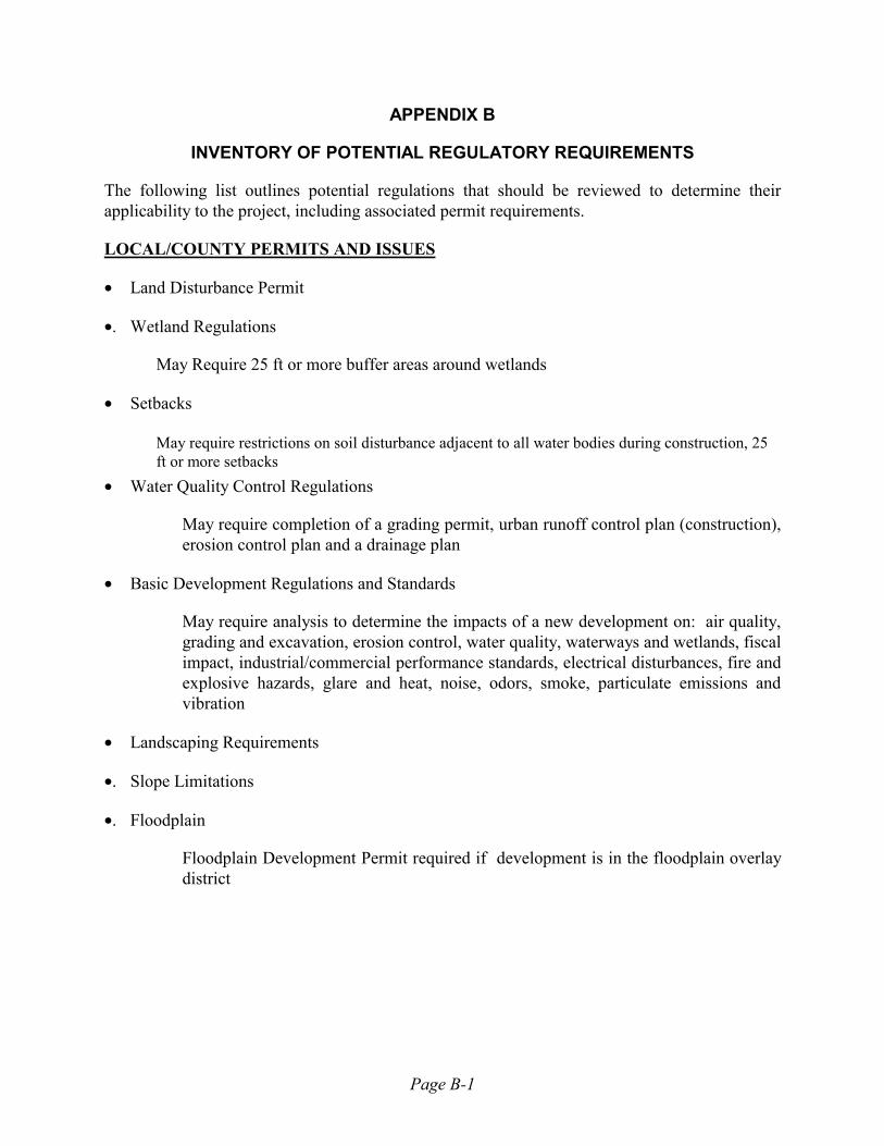
Page B-1
APPENDIX B
INVENTORY OF POTENTIAL REGULATORY REQUIREMENTS
The following list outlines potential regulations that should be reviewed to determine their applicability to the project, including associated permit requirements.
LOCAL/COUNTY PERMITS AND ISSUES
• Land Disturbance Permit
•. Wetland Regulations
May Require 25 ft or more buffer areas around wetlands
• Setbacks
May require restrictions on soil disturbance adjacent to all water bodies during construction, 25 ft or more setbacks
• Water Quality Control Regulations
May require completion of a grading permit, urban runoff control plan (construction), erosion control plan and a drainage plan
• Basic Development Regulations and Standards
May require analysis to determine the impacts of a new development on: air quality, grading and excavation, erosion control, water quality, waterways and wetlands, fiscal impact, industrial/commercial performance standards, electrical disturbances, fire and explosive hazards, glare and heat, noise, odors, smoke, particulate emissions and vibration
• Landscaping Requirements
•. Slope Limitations
•. Floodplain
Floodplain Development Permit required if development is in the floodplain overlay district

Page B-2
STATE PERMITS AND ISSUES
• Colorado Air Quality Control Commission Regulations (Regulations 1-13) •. NPDES Construction Permit •. Stormwater Pollution Prevention Plan • Underground Storage Tank/Above Ground Storage Tank (UST/AST) registration - Colorado Code
of Regulations • Federal Insecticide, Fungicide, and Rodenticide Act (FIFRA) •. Colorado Pesticide Applicators� Act • Air Quality Permit for Construction (Colorado Revised Statues, Article 12, Section 25-12-101) • Resource Conservation and Recovery Act (RCRA) •. Colorado Groundwater Management Act •. Groundwater Protection Act •. Colorado Water Quality Control Commission Regulations (surface water) •. Section 401 Water Quality Certification •. Minimum Instream Flows •. Cultural Resources - State Historic Preservation Officer •. Wildlife Issues Concerns regarding project impact on migration routes, wintering and calving areas, and
fisheries
FEDERAL PERMITS
• Clean Air Act - Title V •. Clean Water Act •. Section 404 of the Clean Water Act - Wetlands •. Floodplain/Floodway/Floodfringe - FEMA •. Migratory Bird Treaty Act of 1918 •. Federal Endangered Species Act of 1973 •. Superfund Amendment and Reauthorization Act of 1986 (SARA) Includes Emergency Planning Notification, Emergency & Hazardous Chemical Inventory,
Community Right-To-Know Act and Toxic Chemical Release (Note: County or fire district may have reporting thresholds that are stricter than the federal
and state regulations.) • Occupational Safety and Health Act (Code of Federal Regulations, 29 CFR 1910.1200)
F:\BMP Manuals\Golf Course BMPs.doc

Wright Water Engineers, Inc.2490 W. 26th Avenue
Suite 100ADenver, Colorado 80211
www.wrightwater.com
Denver Regional Council of Governments2480 W. 26th Avenue
Suite 200BDenver, Colorado 80211
www.drcog.org