Embed Size (px)
Citation preview
Manifest Destiny and the Growing Nation 1© Teachers’ Curriculum Institute
N
S
EW
0 400 800 kilometers
0
Lambert Azimuthal Equal-Area Projection
400 800 miles
Arkansas River
Rio Grande
Colorado River
PACIFICOCEAN
ATLANTICOCEAN
G u l f o f M e x i c o
Old Spanish Trail
Oregon Trail
California Tr a il
Santa Fe
Tr ail
Mor mon Trail
RO
CK
Y
MO
UN
TA
IN
S
SIERRA NEVADA
SouthPass
GR
EA
T
PL
AI
NS
APPA
LACH
IAN
M
OU
NTA
INS
CASC
ADE
RA
NG
E
M E X I C O
B R I T I S H C A N A D A
LOUISIANATERRITORY
TEXAS
MEXICANCESSION
GADSDENPURCHASE
OREGONCOUNTRY
UNITED STATES,1800
FLORIDA,1819
Santa Fe
Fort Hall
Portland
Independence
Los Angeles
Sacramento
St. Louis
New York
Boston
NewOrleans
SanFrancisco
10°N
120°W
30°N
40°N
20°N
130°W
140°W
50°N
80°W
90°W100°W
110°W
N
S
EW
0 400 800 kilometers
0
Lambert Azimuthal Equal-Area Projection
400 800 miles
USI_LG_U05_01U.S. Territorial Acquisitions, 1803–1853Fourth ProofTCI19 83
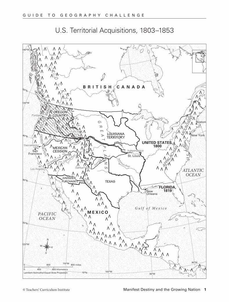
U.S. Territorial Acquisitions, 1803–1853
G U I D E T O G E O G R A P H Y C H A L L E N G E

Manifest Destiny and the Growing Nation 2© Teachers’ Curriculum Institute
G U I D E T O G E O G R A P H Y C H A L L E N G E
Geography Skills
Score 1 point for each correct answer. Use the map on the previous page to check shading and labeling.
1. Adding the Louisiana Territory in 1803 about doubled the size of the United States.
2. Texas was added in 1845 and the Mexican Cession in 1848. The Gadsden Purchase was the other territory acquired from Mexico.
3. The Oregon Trail crossed the Louisiana Territory on the way to Portland. The Santa Fe Trail crossed it on the way to Santa Fe. The California Trail crossed it on the way to Sacramento.
4. The United States added Oregon Country in 1846.
5. The western end of the Old Spanish Trail was Los Angeles.
6. Following the Santa Fe and Old Spanish trails to California required settlers to cross the Arkansas River, Rio Grande, and Colorado River as well as the Rocky Mountains and Sierra Nevada. (Note: Students may not be certain about the Arkansas River.)
7. The California Trail left the Oregon Trail at Fort Hall.
8. The Mormon, California, and Oregon trails crossed the Rocky Mountains at South Pass.
Critical Thinking
Questions may have more than one correct answer. Score 1 to 3 points for each reasonable answer, depending on the strength of students’ geographic reasoning. Possible answers are given here.
9. By following rivers, the trails provided travelers with a source of water along much of their journey.
10. Moving wagons over mountains, and with snow and cold weather, would have been slower than riding over flat land.
11. Had the Louisiana Territory not become part of the United States, Americans traveling to Oregon and California would have had to cross land that belonged to another nation. This might have discouraged Americans from settling in these regions.
Using Scores to Inform Instruction
Geography Skills A score of 6 out of 9 or better indicates that students have acquired sufficient geographic information to proceed with the unit.
Critical Thinking A score of 6 out of 9 or better indicates that students are beginning to understand the relationships between physical geography and the different ways in which people live.
Modifying Instruction
ELL or Learners with Special Education Needs Consider focusing on map-reading questions or limiting the number of “Critical Thinking” questions.
Students with Weak Map or Critical Thinking Skills Assign appropriate pages from the Social Studies Skills Toolkit in the back of the Lesson Masters.