Embed Size (px)
Citation preview

GROUNDWATER PROTECTION GROUNDWATER PROTECTION
POLICIES AND LAND USE POLICIES AND LAND USE
PLANNINGPLANNING
DonalDonal DalyDaly
Geological Survey of Ireland, DublinGeological Survey of Ireland, Dublin
Margaret KeeganMargaret Keegan
Environmental Protection Agency, WexfordEnvironmental Protection Agency, Wexford
Peter Peter McConveyMcConvey
Geological Survey of Northern Ireland and Geological Survey of Northern Ireland and
Environment and Heritage Service, NIEnvironment and Heritage Service, NI
RoI:Regulatory Roles
• Primary responsibility for management and
protection of water resources rests with the
Local Authorities and the Environmental
Protection Agency (EPA) in the
implementation of the Water Pollution Act and
Regulations.
• The Geological Survey of Ireland (GSI)
provides valuable hydrogeological technical
support and prepares Groundwater
Protection Schemes for Local Authorities.

RoI:Regulatory Roles
• The EPA in association with the GSI and
DELG draft Groundwater Protection
Responses for potentially polluting activities
e.g. landfills, landspreading of organic
wastes, onsite systems for single houses,
(storage tanks, farmyards, motorways - in the
future).
• The Department of the Environment and
Local Government (DELG) is responsible for
the development of policy in this area.
RoI Groundwater:
A Major Resource•• 2020--25% of drinking water overall25% of drinking water overall
•• >50% in many counties>50% in many counties
•• maybe >200,000 wells drilled; 10maybe >200,000 wells drilled; 10’’s thousands s thousands
in usein use
•• several 100s of new wells drilled each yearseveral 100s of new wells drilled each year
•• Substantial resources unusedSubstantial resources unused

Two Main Components
1. Land Surface Zoning,
giving groundwater protection zones
2. Groundwater Protection Responses for
potentially polluting activities
– degree of acceptability
– conditions/restrictions
– investigation requirements
Both are encompassed in a GIS

Land Surface Zoning Component3 Main Elements
• Division of the entire land surface on the
basis of the Vulnerability of the underlying
groundwater to pollution
• Delineation of Source Protection Areas (SPAs)
• Delineation of Aquifers
These elements combine together to give Groundwater Protection Zones
Screen Capture of MapInfo Map showing Vulnerability Rating
Source Protection Areas (SPAs)
•• Inner Protection AreaInner Protection Area
-- to protect against microbial pollutionto protect against microbial pollution
-- based on 100based on 100--day time of travel (ToT)day time of travel (ToT)
•• Outer Protection AreaOuter Protection Area
-- encompasses ZOC of sourceencompasses ZOC of source
•• Boundaries of SPAsBoundaries of SPAs
-- Based on horizontal flowBased on horizontal flow
Delineation of source protection zones (SPZs)
around a public supply well

Matrix of Source Protection Zones
VULNERABILITY
RATING
SOURCE PROTECTION ZONE
Inner (SI) Outer (SO)
Extreme (E)
High (H)
Moderate (M)
Low (L)
SI/E
SI/H
SI/M
SI/L
SO/E
SO/H
SO/M
SO/L
Obtained by superimposing the Vulnerability Map on
the Source Protection Area Map
Aquifer Categories
�Regionally Important (R) Aquifers(i) Karstified limestone aquifers (Rk)
(ii) Fractured bedrock aquifers (Rf)
(iii) Extensive sand/gravel (Rg)
�Locally Important (L) Aquifers(i) Sand/gravel (Lg)
(ii) Bedrock which is generally moderately productive (Ll)
(iii) Bedrock which is moderately productive only in local zones (Lm)
�Poor (P) Aquifers(i) Bedrock which is generally unproductive except for local zones (Pl)
(ii) Bedrock which is generally unproductive (Pu)

Screen capture of MapInfo map showing Aquifer Classification
Screen Capture of MapInfo map, showing Protection Zones
and Responses for a proposed development.
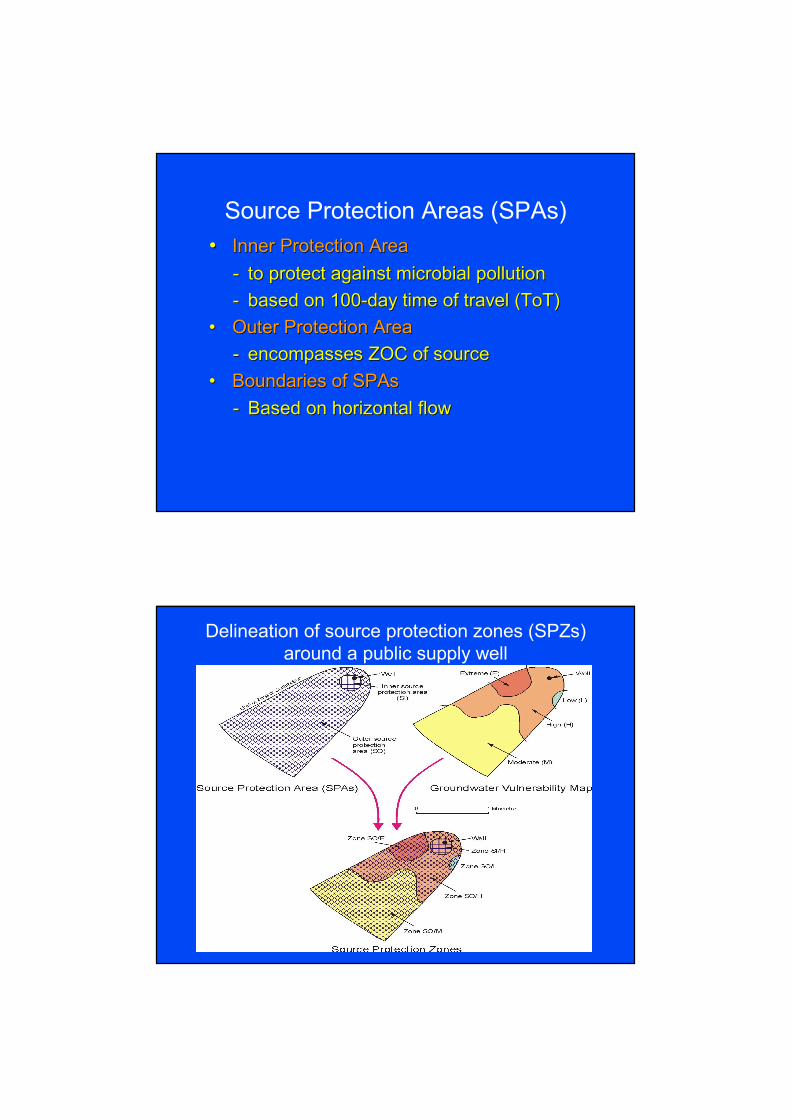
Matrix of Resource Protection Zones
Extreme (E)
High (H)
Moderate (M)
Low (L)
RESOURCE PROTECTION ZONES
Regionally Important
Aquifers (R)
Locally Important
Aquifers (L)
Poor Aquifers
(P)
Rk Rf/Rg Lm/Lg L1 P1 Pu
VULNERABILITY
RATING
Rk/E
Rk/H
Rk/M
Rk/L
Rf/E
Rf/H
Rf/M
Rf/L
Lm/E
Lm/H
Lm/M
Lm/L
L1/E
L1/H
L1/M
L1/L
P1/E
P1/H
P1/M
P1/L
Pu/E
Pu/H
Pu/M
Pu/L
Obtained by superimposing the Vulnerability Map on
the Aquifer Map
Groundwater Protection Response
MatricesBy consulting a response matrix, a planner or developer can determine:
�whether or not a development is likely to be acceptable on that site;
�the further investigations that may be necessary to reach a final decision;
�the planning and licensing conditions that may be necessary
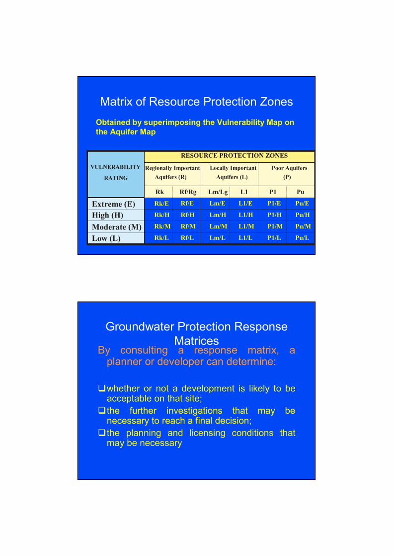
Response Matrix for On-site Systems
for Single Houses
SOURCE
PROTECTION
RESOURCE PROTECTION AREA
Aquifer Category
VULNERABILITY AREA Regionally
Imp
Locally
Imp.
Poor
Aquifers
RATING Inner (SI) Outer
(SO)
Rk Rf/Rg Lm/Lg Ll Pl Pu
Extreme (E) R32 R31 R22 R22 R21 R21 R21 R21
High (H) R24
R23
R21
R1 R1 R1 R1 R1
Moderate (M) R24 R23 R1 R1 R1 R1 R1 R1
Low (L) R24 R1 R1 R1 R1 R1 R1 R1
R22
Response - R22
Acceptable subject to normal good practice and
the following additional condition:
1) There is a minimum thickness of 2 m
unsaturated soil/subsoil beneath the invert of
the percolation trench of a conventional septic
tank system;
OR
1) An intermittent filter, constructed wetlands or a
mechanical aeration system with a polishing
filter, as described in EPA (2000) must be used
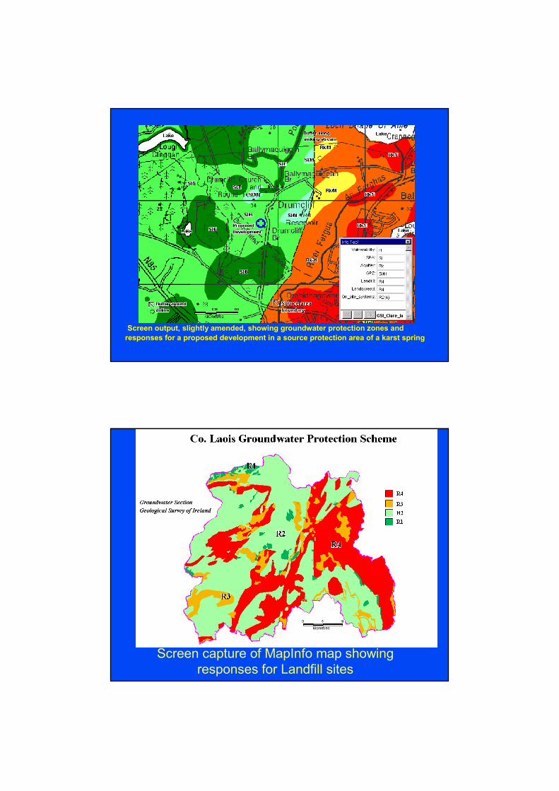
Screen output, slightly amended, showing groundwater protection zones and
responses for a proposed development in a source protection area of a karst spring
Screen capture of MapInfo map showing
responses for Landfill sites

NI:Regulatory Roles
• Primary responsibility for management and
protection of water resources rests with
Environment and Heritage Service (EHS), an
Agency within the Department of Environment
• EHS presently source hydrogeological
technical support from Geological Survey of
Northern Ireland (GSNI) and the related
British Geological Survey (BGS)
Factors influencing
approach in NI compared with
RoI
• Significantly less reliance on groundwater for public supply ~ 8% hence historically lower priority to assess and manage
• However still several
thousand private wells
• Areas of fast flow karstic
limestone less extensive
• More influenced by approaches
taken by UK regulators for
‘consistency’
Drilling of water wellDrilling of water well

Groundwater
Protection Policy
• Published in 2001
• Follows general concepts used
in UK and RoI
- Resource Protection
- Source Protection Zones
• Policy statements outlining
EHS position regarding activities that may impact groundwater flow or quality
NI Regional Vulnerability
Map (Resource Protection)
• British Geological Survey carried out first comprehensive hydrogeologicalreconnaissance survey in 1992-94
• From this work Regional
Groundwater Vulnerability Map
produced in 1994 in association
with SSLRC/DARD
• Approach based upon that
developed for Environment Agency in UK

Vulnerability Classes
Geological Classes Soil Classes (Leaching Potential)
High
Highly Permeable Intermediate
Low
High
Moderately Permeable Intermediate
Low
Weakly Permeable Not assessed
Increasing Vulnerability
Regional Vulnerability Map

Use of Map
• Drift not assessed
due to scale of map and
significant local
variability/limited data
• Useful for strategic decisions with respect to development and land use
• For specific developments will generally require interpretation of more local / site specific data
Future for NI
• Assessment of impact of land use
on groundwater resources
less precisely defined in NI
than RoI due to different
environmental protection
priorities and
hydrogeological conditions
• Recent legislation and increasing awareness of relationship between groundwater and surface water changing this

Water Framework Directive
• EC Water Framework Directive requires a comprehensive assessment of all waters including groundwater to be undertaken
• Member States must aim to achieve ‘good status’ for all waters by 2015
• By 2004 initial ‘characterisation’ of all waters must be complete
Water Framework Directive
• For groundwaters part of the analysis required
will be to better understand the relationship
between soils and subsoils (drift) with
underlying aquifers especially regarding the
degree of protection offered from surface
activities
• Also need to consider role of groundwater as a
pathway, potentially transferring contaminants
within a catchment to surface waters

Groundwater as a pathway
Future
• Part of the characterisation will be to identify pressures that groundwater may be subject to in
a particular area
• This will necessarily require
a spatial assessment of land
use with respect to potential
for qualitative or quantitative
impacts, for example;
- agriculture (nitrates)
- urban (hydrocarbons,
solvents)
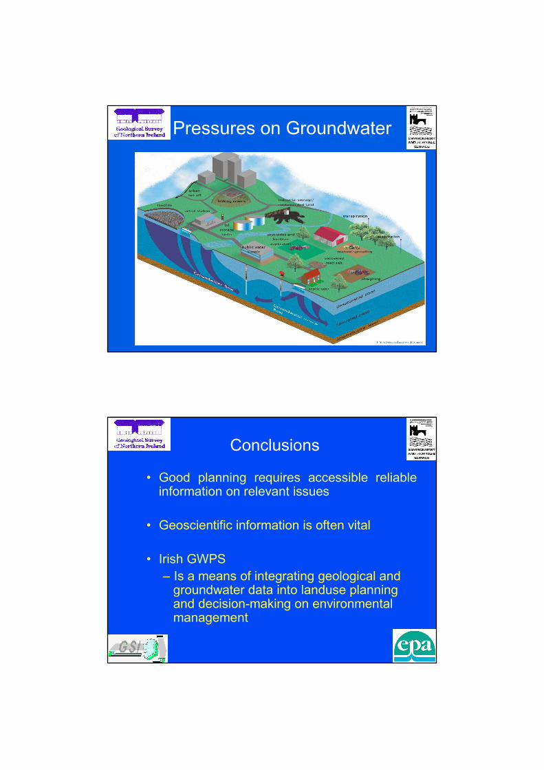
Pressures on Groundwater
Conclusions
• Good planning requires accessible reliable information on relevant issues
• Geoscientific information is often vital
• Irish GWPS
– Is a means of integrating geological and groundwater data into landuse planning and decision-making on environmental management

Future for NI and RoI
• Resources will be applied to meeting the
requirements of the Water Framework
Directive in the next 3-5 years
• Will significantly increase our understanding
of the inter-relationship between land use
and potential impact upon groundwaters
and associated ecosystems
• Significant amount of data will become
available in GIS format allowing a variety of
analysis
Future for NI and RoI
• Opportunity will exist to develop more comprehensive, targeted and user friendly guidance for developers and planners
• Opportunity also to make geological/hydrogeological information more accessible to the general public
• Help lead to better integration between river basin and land use planning to meet statutory environmental objectives