Embed Size (px)
Citation preview
Groundwater Management in Algeria
Draft Synthesis Report
Food and Agriculture Organization of the United Nations
Rome, 2009
el. +39 06 93938367 - Fax +39 1786034698 - email: [email protected]
© ICU 2011

. . . . . . . . .
The designations employed and the presentation of material in this information product do not imply the expression of any opinion whatsoever on the part of the Food and Agriculture Organization of the United Nations concerning the legal or development status of any country, territory, city or area or of its authorities, or concerning the delimitation of its frontiers or boundaries.

1 Background
Algeria is the largest country bordering the Mediterranean
Sea and the second largest on the African continent. It
covers an area of 238 million km2 of which 8.3 million km2 is
cultivated. It borders the Sahara desert in the south and so
most of the country (84 percent) has a desert climate. This
is in contrast to the north of the country (16 percent) which
enjoys a Mediterranean climate.
The northern coastal area is hilly and even mountainous with
a fertile plain between the coast and the 1,500 km long Tell
Atlas mountain chain running parallel to the coast. The
Saharan Atlas range runs south of the Tell Atlas and parallel
to it. Rainfall is variable across this region with 350 mm
average annual rainfall in the west and as much as 1,000
mm in the north east. Rainfall decreases rapidly south of the Saharan Atlas range and
towards the Sahara desert. Here average annual rainfall is less than 100 mm and this is
usually concentrated over a short time period. In this region oases dominate both the life and
culture of the population. Prolonged and persistent droughts in recent decades have also
resulted in less surface water availability and this encouraged the exploitation of groundwater.
Algeria has a population of almost 35 million people most of whom are concentrated in the
north and west of the country along the fertile coast and Tell Atlas region. In this region the
population density is 215 inhabitants/km2. This is in sharp contrast to southern desert area
where the density is only 0.7 inhabitants/km2. Population is expected to reach 46 million by
2050.
Agriculture still plays a dominant role in the country’s economy. Twenty years ago more than
75 percent of the active population in the north was engaged in agriculture. But this has now
reduced to about 20 percent.
In the south of the country it is a different story. In 1967 the population was only 0.9 million.
But this rose to almost 2 million by 1987 and is expected to reach over 3 million by 2010.
Some 40 percent of the population now depend on agriculture for their livelihood. Life and
culture in the region is based around the traditional oases which have been exploited for
centuries. In addition to their productivity, oases are now seen as a protection against
climatic risks – sun, heat, winds and sand erosion. The ecological and environmental role of
oases is significant because they complement the growing urban environment, contribute to
regional climatic equilibrium, and safeguard vegetation and animal species.
2 Water resources and water use
The annual renewable water resources from FAO AQUSTAT database are shown in Table 1
together with annual withdrawals for agriculture, domestic use, and for industry. Algeria is
among the countries where water availability per capita is below the World Bank’s water
poverty threshold of 1,000 CM/capita/yr. Renewable water resources are limited – estimated
to be 11,670 MCM/yr – which corresponds to about 382 CM/capita/yr. The exploitable
resources at present are only 7,900 MCM/yr.
Figure 1 Algeria

Table 1 Annual water resources and water use in Algeria (from FAO AQUASTAT 2000)
Renewable Exploitable
Surface water (MCM) 10,150 6,000
Groundwater (MCM) 1,517 1,900
Total dam capacity (MCM) 6,000
Total (MCM) 11,667 7,900
Total/capita (CM) 382
Withdrawals
Agriculture (MCM) 3,940
Domestic (MCM) 1,330
Industrial (MCM) 800
Total withdrawals (MCM) 6,070
Water withdrawal/capita (CM) 173
Algeria has significant surface water resources mainly in the north of the country were rainfall
is more favourable. A significant portion is already captured by a number of medium and
large dams (storage capacity of 6,000 MCM) and exploited for domestic use, industry, and
agriculture.
Before the construction of the first dams in the early 20th century, groundwater, either in the
form of springs or shallow wells, was the only reliable source of water available. The rest
came from surface waters diverted from seasonal rivers and spread onto the land as spate
irrigation.
3 Matching groundwater supply and demand
Algeria also has significant groundwater resources both renewable and non-renewable fossil
water (Table 2).
Table 2 Groundwater available and withdrawn using local data sources (MCM)
Region Exploitable
water (MCM)
Withdrawals
(MCM)
Northern region 1,9001
2,4002
Approx 12,000 boreholes; 9,000 springs; 100,000 wells.
37% domestic use; 63% irrigation
Aquifers mostly rechargeable but over-exploited
Southern region 5,0002
2,2002
Approx 1,640 boreholes; 700 foggaras
25% domestic use; 75% irrigation
Economically exploitable groundwater from fossil aquifers
Total 6,900 4,600
Sources: 1 FAO AQUASTAT 2 Country Report
IN THE NORTH
In the mountainous north, 147 shallow renewable aquifers have been identified which are
exploited using shallow wells and springs. In pre-colonial times the cities of Algiers, Tlemcen,
Constantine, Candle and others were supplied with fresh produce from gardens irrigated from
these easily exploited shallow aquifers. Some 1,900 MCM/yr of renewable groundwater is
available (Table 2) though withdrawals are estimated to be 2,400 MCM/yr which means that
some of these aquifers are being over-exploited mainly due to increasing water demand but
also because of a lack of effective groundwater management. Poor management is linked to
the poor knowledge of the resource, the proliferation of illicit wells, and poor coordination
between the various authorities with responsibility for groundwater. Estimates suggest that
groundwater contributes up to 63% of water needs in the region.
There are three main aquifer types – alluvial filling by rainfall and river debris along the
coastal plains; sandstone and limestone aquifers in the mountainous areas; and alluvial
aquifers along the river valleys. Most of these are rechargeable annually. The principal
watersheds that include the main aquifers in the north are listed in Table 3. The principal
aquifers are listed in Table 4.
Table 3 Principal northern watersheds and groundwater resources1
Watershed Oranie, Chott
Chergui (OCC)
Cheliff, Zahrez
(CZ)
Algérois, Hodna
Soumam (AHS)
Mellegue, Seybouse,
Constantinois (MSC)
Total
Potential resource (HCM) 400 335 770 470 1,975
Withdrawals (HCM) 391 573 920 577 2,461
1 Source: Country Report
Table 4 Principal northern aquifers1
Aquifer Water use
(HCM)
Aquifer Water use
(HCM)
Aquifer Water use
(HCM)
Great plains Sandstone and limestone formations Alluvial aquifers nr major rivers
Mitidja 327 Tlemecen 90 Cheliff 56
Annaba 45 Chott Chergui 55 Soummam 100
Mascara 70 Plateau de Saida 50 Sebaou 53
Sidi Bel Abbes 44 Tolga 60 Rhumel-Kabir 40
Plain Hodna 110
Total 596 255 249 1 Source: Country Report
Groundwater exploitation is limited by altitude, fragmentation, and compartmentalization of
reservoirs due to erosion and/or tectonics, and the risk of salt intrusion near the coast or in
the vicinity of closed depressions.
The mountains provide the main source of surface water for agriculture and domestic use and
for groundwater recharge. Only seasonal streams flow south from the Tell Atlas.
IN THE SOUTH
In the southern Saharan region groundwater comprises mainly fossil water with negligible
recharge. Country Report estimates suggest the economically exploitable potential is around
5,000 MCM/yr. This is based on modelling estimates which take account of water quality and
costs of production. Current consumption is only about 2,200 MCM/yr (Table 2).
Groundwater contributes about 96 percent of total water use in the region.
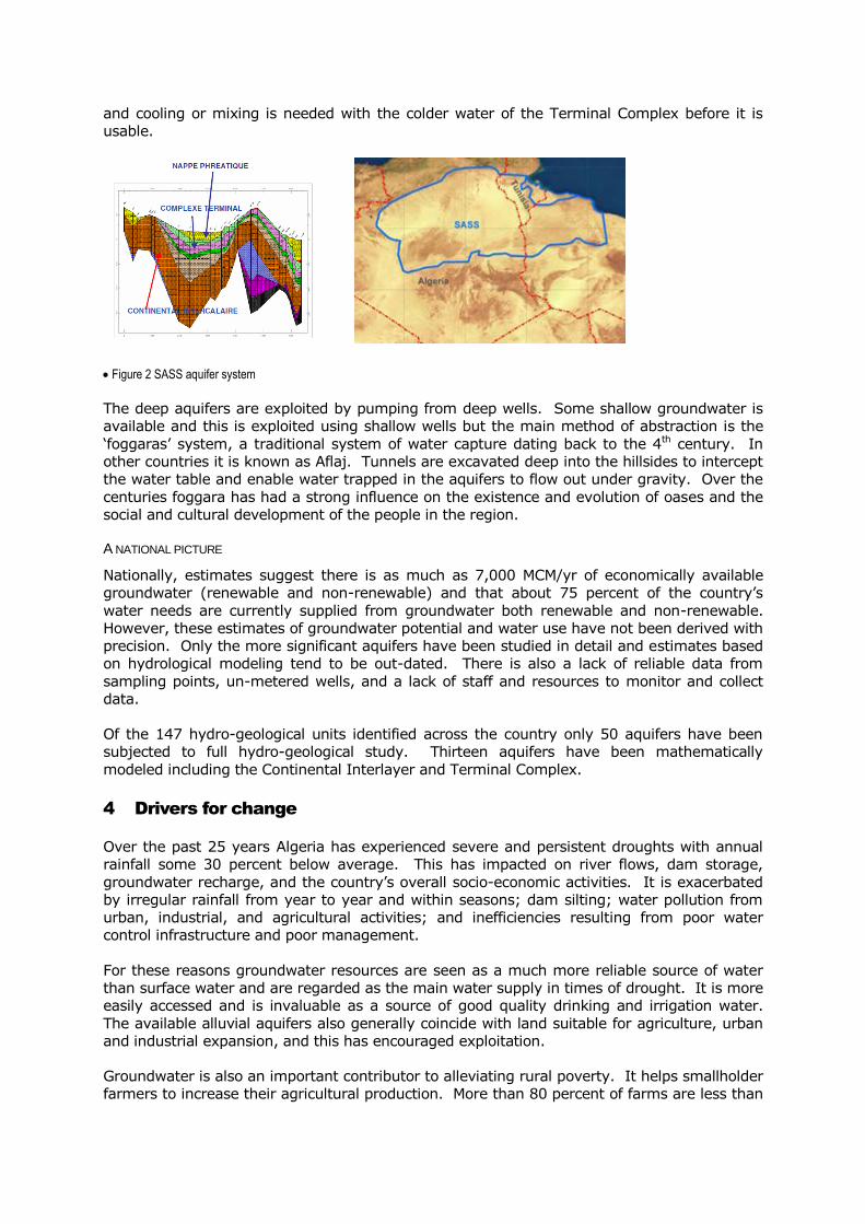
Although six main aquifers have been identified the bulk of water resources are contained
within two major confined aquifer systems – the Terminal Complex (CT) and the Continental
Interlayer (CI). These aquifers are jointly exploited with Libya and Tunisia and together they
form the Septentrional Saharan Aquifer System (SSAS). There is also a shallow rechargeable
aquifer that accounts for about 700 MCM annually (Figure 2).
Water quality is generally poor. Water from the Terminal Complex is highly mineralized with
salinity levels between 4 and 9g/l. This and the costs of developing and operating deep wells
limits abstraction. Groundwater from the Continental Interlayer is hot – between 45-65°C –
and cooling or mixing is needed with the colder water of the Terminal Complex before it is
usable.
Figure 2 SASS aquifer system
The deep aquifers are exploited by pumping from deep wells. Some shallow groundwater is
available and this is exploited using shallow wells but the main method of abstraction is the
‘foggaras’ system, a traditional system of water capture dating back to the 4th century. In
other countries it is known as Aflaj. Tunnels are excavated deep into the hillsides to intercept
the water table and enable water trapped in the aquifers to flow out under gravity. Over the
centuries foggara has had a strong influence on the existence and evolution of oases and the
social and cultural development of the people in the region.
A NATIONAL PICTURE
Nationally, estimates suggest there is as much as 7,000 MCM/yr of economically available
groundwater (renewable and non-renewable) and that about 75 percent of the country’s
water needs are currently supplied from groundwater both renewable and non-renewable.
However, these estimates of groundwater potential and water use have not been derived with
precision. Only the more significant aquifers have been studied in detail and estimates based
on hydrological modeling tend to be out-dated. There is also a lack of reliable data from
sampling points, un-metered wells, and a lack of staff and resources to monitor and collect
data.
Of the 147 hydro-geological units identified across the country only 50 aquifers have been
subjected to full hydro-geological study. Thirteen aquifers have been mathematically
modeled including the Continental Interlayer and Terminal Complex.
4 Drivers for change
Over the past 25 years Algeria has experienced severe and persistent droughts with annual
rainfall some 30 percent below average. This has impacted on river flows, dam storage,
groundwater recharge, and the country’s overall socio-economic activities. It is exacerbated
by irregular rainfall from year to year and within seasons; dam silting; water pollution from
urban, industrial, and agricultural activities; and inefficiencies resulting from poor water
control infrastructure and poor management.
For these reasons groundwater resources are seen as a much more reliable source of water
than surface water and are regarded as the main water supply in times of drought. It is more
easily accessed and is invaluable as a source of good quality drinking and irrigation water.
The available alluvial aquifers also generally coincide with land suitable for agriculture, urban
and industrial expansion, and this has encouraged exploitation.
Groundwater is also an important contributor to alleviating rural poverty. It helps smallholder
farmers to increase their agricultural production. More than 80 percent of farms are less than

10 ha and account for some 45 percent of the total irrigated area. About 97 percent of small
farms rely on groundwater using shallow wells and boreholes. Groundwater also provides
about 85 percent of domestic and industrial water needs.
The advantages of groundwater are seen as low cost, ease of access in remote areas, low
environmental impact when compared to dams and desalination plants, and low evaporation
losses when compared to dams in arid and semi arid areas.
4.1 Agriculture
Almost all productive farms are now privately managed, despite the diversity of forms of
ownership. Cereal production dominates but in recent years there has been growth in high
value cropping of fruits and vegetables.
The cultivated area covers some 8.3 million ha. Although it is estimated that about 569,000
ha is equipped for irrigation, only 453,000 is actually irrigated. However, this contributes
over 40 percent of national agricultural production. Agriculture is the country’s main
consumer of water taking almost 4,000 MCM/yr and is the sector which is having the greatest
impact on groundwater.
Irrigation is divided into major irrigated areas which were mainly constructed during the
colonial period (GPI) and rely on surface water; and the more recent developments known as
small and medium hydraulic systems (PMH). The latter accounts for about 363,000 ha and is
irrigated mainly using groundwater. It is this sector that contributes substantially to the
supply of fruit and vegetables and which has benefited from large investment subsidies up to
80 percent from the National Fund for Development. This level of investment has remained
relatively stable even though there were budget restrictions during the oil crisis.
4.2 Environment
There are growing concerns about the impact of groundwater development on the
environment and also the impact of household, industrial, and agricultural pollution of
groundwater.
Wastewater from urban and industrial sources, some 820 MCM annually, is discharged
untreated into the natural environment and this contributes to worrying levels of pollution
both for surface water and for alluvial groundwater which is re-charged from surface water.
Wadis, which would normally be able to recover naturally from urban pollution are now unable
to do so because of the increased urban discharges. The most affected wadis include Tafna,
the Macta, the Cheliff, the Sébaou, and the Soummam Seybouse.
There are also concerns about diffuse pollution from intensive agriculture and from irrigation
using brackish water and untreated wastewater which are linked to poor water management.
Table 5 shows data collected on nitrate levels in the Mitidja aquifer over a period of only four
years.
Table 5 Nitrate in groundwater in the Mitidja aquifer (mg/l)1
2000 2003 2004
Mitidja west 12.6 14.8 16.5
Mitidja central 73 79 84
Mitidja east 65 82 78 1 Country Report
In the coastal aquifers over-exploitation is lowering water tables which leads to salt water
intrusion, and irreversible aquifer salinization.
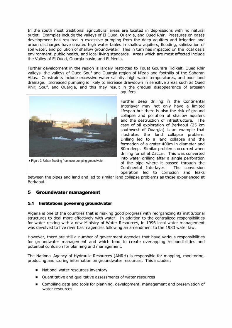
In the south most traditional agricultural areas are located in depressions with no natural
outlet. Examples include the valleys of El Oued, Ouargla, and Oued Rhir. Pressures on oases
development has resulted in excessive pumping from the deep aquifers and irrigation and
urban discharges have created high water tables in shallow aquifers, flooding, salinization of
soil water, and pollution of shallow groundwater. This in turn has impacted on the local oasis
environment, public health, and local living standards. Areas which are most affected include
the Valley of El Oued, Ouargla basin, and El Menia.
Further development in the region is largely restricted to Touat Gourara Tidikelt, Oued Rhir
valleys, the valleys of Oued Souf and Ouargla region of M'zab and foothills of the Saharan
Atlas. Constraints include excessive water salinity, high water temperatures, and poor land
drainage. Increased pumping is likely to increase drawdown in sensitive areas such as Oued
Rhir, Souf, and Ouargla, and this may result in the gradual disappearance of artesian
aquifers.
Further deep drilling in the Continental
Interlayer may not only have a limited
lifespan but there is also the risk of ground
collapse and pollution of shallow aquifers
and the destruction of infrastructure. The
case of oil exploration of Berkaoui (25 km
southwest of Ouargla) is an example that
illustrates the land collapse problem.
Drilling led to a land collapse and the
formation of a crater 400m in diameter and
80m deep. Similar problems occurred when
drilling for oil at Zaccar. This was converted
into water drilling after a single perforation
of the pipe where it passed through the
Continental Interlayer. The conversion
operation led to corrosion and leaks
between the pipes and land and led to similar land collapse problems as those experienced at
Berkaoui.
5 Groundwater management
5.1 Institutions governing groundwater
Algeria is one of the countries that is making good progress with reorganizing its institutional
structures to deal more effectively with water. In addition to the centralized responsibilities
for water resting with a new Ministry of Water Resources, in 1996 local water management
was devolved to five river basin agencies following an amendment to the 1983 water law.
However, there are still a number of government agencies that have various responsibilities
for groundwater management and which tend to create overlapping responsibilities and
potential confusion for planning and management.
The National Agency of Hydraulic Resources (ANRH) is responsible for mapping, monitoring,
producing and storing information on groundwater resources. This includes:
National water resources inventory
Quantitative and qualitative assessments of water resources
Compiling data and tools for planning, development, management and preservation of
water resources.
Figure 3 Urban flooding from over pumping groundwater

The Water Directorates of Wilaya (DHW). Administrative representatives of the Ministry of
Water Resources at the Wilaya:
Participate in inventories, studies, and updating databases of aquifers in their wilaya
Supervise and manage drilling operations
Issue drilling permits
Organize the collection of information
The Algerian Water Organization (ADE) is responsible for public drinking water services
throughout the country. Their duties include:
Managing infrastructure for mobilizing and distributing drinking water
Technical, economic, and financial management of groundwater
Reducing water wastage.
The National Office of Irrigation and Drainage (ONIDA) undertakes a similar role to the ADE
but it manages the infrastructure and groundwater resources for irrigation.
Watershed Agencies (ABH) reflect the principle of joint and integrated management of water
resources throughout the watershed included in the framework of the new water policy. Five
ABH were created with responsibility for developing and updating cadastre hydraulics and the
hydrological balance of the watershed, and collecting data, documents, and information on
water resources, levies, and water consumption. But they need additional resources and
increased capacity to this work.
Alongside these agencies watershed committees were created for consultation purposes
comprising representatives of the State and local water users. These committees are
mandated to discuss and formulate opinions on all issues related to water in the watershed.
5.2 The regulatory framework
In 2005 laws were established for the protection and preservation of groundwater. These
laws are designed to prohibit the development of new wells, restrict discharges in critically
over-exploited aquifers, and regulate or prohibit groundwater pollution from household
sewage, industry, and agriculture. Measures were adopted to deal with infringement of these
laws but it is questionable whether these have been effectively implements or are having the
desired effect.
5.3 Management tools
Mathematical models are now being used to assess groundwater resource potential and for
management purposes. However, the development of effective models requires a good
understanding of the aquifer parameters and good data obtained from monitoring networks.
The main aquifers are all equipped with piezometric monitoring networks and campaigns to
measure groundwater levels are regularly conducted by the regional offices of the ANRH.
These data are processed and published in tables and maps together with analysis to highlight
trends in both groundwater quantity and quality.
Thirteen major aquifers, have now been modeled – Mitidja, Mostaganem, Maghnia, Lower
Soummam, Sidi Bel Abbes, Mascara, Ain Oussera, Hodna, Annaba Bouteldja, near-shore
Chergui, CI, CT).
5.4 Economic instruments
5.4.1 Cost of developing groundwater
It is difficult to compare the cost of developing groundwater and water from other sources
because of the many different ways that water is exploited. The cost of drilling for
groundwater varies considerably depending on whether it for deep wells in the south of the
country, often from 200m, or shallow wells in the north, no more that 3-4 m deep. According
to the National Agency of Hydraulic Resources (ANRH) the average price for drilling a well is
US$200/m. An equipped well drilled in simple geology would be US$340/m rising to
US$380/m for more complex geology. Depths do differ across the country ranging from 40m
to over 1,000m.
Prices for surface water depend on the cost of dams and distributing water over long
distances. Desalinated water prices vary depending on whether the plant is small producing
up to 10,000 CM/day or large producing over 200,000 CM/day like that in Algiers.
Table 6 provides indicative costs for surface water, groundwater, and desalinated water.
Table 6 Cost of water
Source Cost (US$/CM)
Groundwater 0.05 Based on costs of drilling at Mazafran (see below)
Surface water 0.2-0.5 Average cost ‘at the foot of the dam’
Desalinated water 0.5-0.6 Average of nine desalination plants
Source: Country Report
5.4.2 Well drilling costs at Mazafran
In 2006 forty eight wells were drilled and brought into production in Mazafran yielding 31.85
MCM/yr, an average of 0.663 MCM/yr per well.
The average cost of drilling and equipping a well is US$ 165,000 (Table 7). This is about
US$870/m for an uncapped well and US$1,100/m for a fully equipped one.
Table 7 Average cost of drilling and equipping a well in Mazafran
Item Cost (US$)
Drilling 129,326
Well cover construction 7,000
Energy connection 12,643
Equipment submerged electric pump 16,416
Total 165,385
Source: Country Report
The average cost of operating a well based on an average yield per well of 0.663 MCM/yr
without depreciation costs comes to US$0.05/CM (Table 8).
Table 8 Operating costs for wells at Mazafran (not including depreciation costs)
Designation Cost (US$) Average
production (CM)
Cost/CM
(US$)
Electricity 25,214 663,000 0.038
Chemical products 1,309 0.002
Personal Expenses 9,919 0.015
Total 36,442 0.050
Source: Country Report
5.4.3 The price of water
The pricing of public drinking water supply and sanitation is meant to cover all or part of the
financial charges related to the operation, maintenance, and renewal of infrastructure. Pricing
is differentiated by land price zones and various categories of users.
The pricing of water for agricultural use is designed to cover the costs of maintenance and
operation of irrigation and drainage and for the renewal of infrastructure works. The price per
cubic meter of water varies depending on each irrigated perimeter and the practices used
(Table 9). But clearly the price is less than the cost of developing groundwater.
Table 9 Typical water prices for agricultural water consumption
Irrigation perimeters Volumetric
tariff (US$/m3)
Sig 0.034
Habra 0.034
Mina 0.027
Lower Cheliff 0.027
Medium Cheliff 0.027
High Cheliff 0.034
Western Mitidja 0.034
Hamiz 0.034
Guelma-Bouchegouf 0.034
Saf Saf 0.027
Bounamoussa 0.034
Source: Country Report
The current pricing system for water, even though charges have been rising in recent years,
does not induce water-saving behaviour. Water charges are still below the actual costs of
development even though legislation in 2005 requires that water tariffs for services should be
based on long-term financial viability, and provide incentives to conserve water and protect
water quality. But the law also recognises the importance of social equity and rational water
use. So selectivity and gradualism are guiding principles on which water charges are based
and the rate at which charges are increased.
What is also not clear from the Country Report however, is just how well these charges are
administered and collected.

5.5 Impact of droughts on groundwater management
The intense droughts over the past 25 years have particularly affected the western areas of
the country. Shortages in surface water in turn led to further exploitation of groundwater
with significant drilling programmes that exceeded some 60 linear kilometers a year. All this
resulted in groundwater shortages but also in resulted in additional costs from increased
drilling activities as farmers deepen their wells to reach falling water tables, and financial
losses from abandoned orchards which no longer had a viable water supply. Lax regulation
and management is blamed for the proliferation of illegal drilling, poor knowledge of
exploitable resources and inadequate coordination from the ANRH who is supposed to
regulate and issue drilling permits.
5.6 Trans-boundary aquifer management
In addition to national groundwater management there is also the issue of shared
groundwater with Libya and Tunisia. Groundwater knows no national boundaries and so
Algeria seeks to manage and share its deep fossil groundwater with Libya and Tunisia as a
member of the recently formed Sahara Aquifer System (SASS).
This organisation was formalized in 2002 to create a permanent mechanism for consultation
and management of the shared resource. The three countries have agreed on the need to
ensure continuity of work to improve the knowledge of the system and its operation, and the
need to establish a mechanism for consultation. The aim is to coordinate, promote, and
encourage sound management of SASS. The first phase of development will include the
establishment of a Steering Committee comprising the national organisations responsible for
groundwater resources, a scientific committee, and a coordination unit managed and hosted
by the Sahara and Sahel Observatory (OSS) based in Tunis. This is discussed further in the
Libya and Tunisia country papers.
6 Future perspectives
Groundwater will continue to play an important role in Algeria, both for drinking water supply
in small and medium-sized metropolitan areas and for agricultural development. Local
estimates suggest that by 2025 groundwater supplies could be fully exploited and in some
places they will be over-exploited as they are already in parts of the north. Beyond this date
increases is water demand are then likely to be met from further development of surface
water and non-conventional water resources such as the desalination of seawater for
domestic use and treated effluent for agriculture.
Steps are needed in the future to avoid over-exploitation of groundwater resources,
particularly in the north of the country where most of the expanding population is expected to
reside. However, in the north the increasing coastal population poses pollution problems for
soil water and marine water as well as freshwater supplies. A new strategy for land use is
being developed to achieve a more balanced distribution of population and economic activities
for the highlands, plains, and the southern interior. This land use strategy also involves an
ambitious strategy for transferring water.
The main thrusts of this strategy include:
Improving understanding and management of groundwater resources
Desalination for major cities in the coastal areas focusing on 16 large desalination
plants with a capacity by 2025 of 2.2 MCM/day corresponding to 807 HCM/yr.
Transferring groundwater resources from coastal aquifers to irrigate Tell plains to
complement dam storage from the Tell Atlas
Transferring dam storage from the Tell Atlas to the High Plains and Highlands

Further meet demands from the High Plains and Highlands by transfers from Albian
groundwater
Increasing aquifer recharge.
In the south simulation modeling indicates some 3,500HCM/yr is available from the
Occidental Basin reserves (Grand Erg Occidental, Touati, Gourara). The second major
potential new source is located south of Ouargla in the valley of Oued Mya where simulation
modeling indicates about 600 HCM/yr is available in the Terminal Complex. A large portion of
these flows could be transferred to the north of the country. This is particularly true for the
2,500 HCM/yr that could be abstracted from the area of the Grand Erg Occidental. The
difficulties of access and setting up a system for transferring large quantities of water, the
high cost of drilling and the pumping stations needed to cross the Saharan Atlas, constitute
serious obstacles to this project. However, studies are in progress.
Algeria is now beginning to use remote sensing and GIS technology to map groundwater
resources. Integrating these techniques with classic geological and hydro-geological
exploration methods provide a better platform for improving data collection and its use for
better understanding and managing groundwater resources.
New institutional reforms, both legal and organizational, are also being introduced. New laws
are now designed to increase protection for groundwater resources. Abstractors are not
allowed to increase their pumping and all new wells and boreholes are subject to
authorization by the administration in charge of water resources.
All water abstraction can be regulated or prohibited. Water is also the subject of special
controls regarding the installation of waste pipes, reservoirs, deposit tanks for gas stations,
laying asphalt, industrial construction, and the application of farm fertilizers and manures and
all agricultural products that can impact on the quality of groundwater.
Previous laws emphasized the rehabilitation, revitalization, and better monitoring and control
of water resources. The new laws aim to strengthen and clarify certain provisions for new
abstraction and the operation, management, maintenance, and preservation of infrastructure.
The new measures have been adopted to vigorously fight against any infringement of water
legislation.
Attention is also focusing on demand management as well as on the supply side. Agriculture
is the dominant water user and studies that examine the efficiency of irrigation practices as a
means of reducing water demand could be most beneficial. This is particularly true in the
south where improvements in agricultural practices can not only save precious, irreplaceable
groundwater but also improve crop productivity and enhance the rural and urban
environment.

References
HYDROGEOLOGICAL MAPS
ANRH (2002) Atlas temperatures and evapotranspiration northern Algeria.
ANRH (2000) Explanatory of the map of potential evapo-transpiration northern Algeria at
1/500 000.
ANRH (1999) Water and soil of the wilaya of Tiaret: Note hydrogeological.
ANRH (1993) Map rainfall of Algeria on 1/500 000.
Hydrogeological map of the region of Bechar 1/500 000 and Explanatory.
Hydrogeological map of the region of the Hoggar and Tassili 1/1000 000) and Explanatory.
Ministry of Water of land reclamation and environment-DEMRH (1978) Hydrogeological map
of the region of Algiers 1/100 000.
Ministry of Water of land reclamation and environment-DEMRH (1978) Hydrogeological map
of the plain of Sidi Bel Abbes 1/100 000.
Ministry of Water of land reclamation and environment-DEMRH (1978) Hydrogeological map
of the Plateau de Mostaganem 1/100 000.
Ministry of Hydraulics of land reclamation and environment-DEMRH (1980) Hydrogeological
map of the plain of Biskra 1/200 000.
HYDRO-CLIMATOLOGICAL MAPS
ANRH (?) Map of watersheds of northern Algeria in 1/200 000.
HYDROGEOLOGICAL STUDIES
ABH Algerian-Hodna Soummam (2002) The Wandering of the Agency
ABH Cheliff Zahra (2004) Cadastre Hydraulic watershed Cheliff-Zahra The Basin Cheliff-
Downstream from the dam at Boughzoul.
ACZ (2007) Master Plan for water resources development in the region Cheliff-Zahra.
AHS (2007) Master Plan for water resources development in the region Algerian-Hodna-
Soumam.
AOCC (2007) Master Plan for water resources development in the region Oran near-shore
Chergui.
Anonymous (1990) Potential water in the region of Tamanrasset.
BCEOM-BG-SOGREAH (2005) Study of updating and finalizing the National Plan for Water
(river Regions Center and East) Mission V: report.
CMHA (2007) Master Plan development of water resources in the region Constantinois-
Seybouse-Mellegue.
DEMRH (1973) Study of hydrogeological slick Mascara B-Sourisseau.
DEMRH (1973) Study of hydrogeological slick Sidi Bel Abbes B-Sourisseau.

Grenet B (1966) Logging and conservation of ground water of Plateau SERSOU.
Khadraoui A (2005) Water and soil in Algeria-management and environmental impacts
Mesrati AT (2003) Note on the groundwater resources of the steppe-Ayad (Study No.
036/DHYG/Sept).
MRE-DEAH (2001) Water resources of Algeria – Current Situation-Development Strategy-
regional planning schemes.
National Economic and Social Council (2000) Water in Algeria: The great challenge of
tomorrow.
National Water Plan.
OSS (2003) Northern Sahara Aquifer System (Joint management of a river border).
OSS (2001) Water demand in the Northern Algerian Sahara.
WHO/UNDP (1976) Water supply in western Algeria: Regional Master Plan (wilaya of Saida,
Tiaret, Laghouat) DRAFT.