Embed Size (px)
Citation preview

GROUND WATER SCENARIO OFLAKHIMPUR KHERI DISTRICT, U.P.
(A.A.P.: 2012-2013)By
Dr. D.S. PandeyScientist 'D'
CONTENTS
Chapter Title Page No.
DISTRICT AT A GLANCE ..................2
I. INTRODUCTION ..................5
II. CLIMATE & RAINFALL ..................5
III. GEOMORPHOLOGY & SOIL TYPES ..................6
IV. GROUND WATER SCENARIO ..................6
V. GROUND WATER MANAGEMENT STRATEGY ..................8
VI. GROUND WATER RELATED ISSUE AND PROBLEMS ..................9
VII. MASS AWARENESS PROGRAMME ..................9
PLATES:
I. INDEX MAP OF LAKHIMPUR KHERI DISTRICT, U.P.
II. PRE-MONSOON DEPTH TO WATER LEVEL MAP (MAY, 2012) OF
LAKHIMPUR KHERI DISTRICT, U.P.
III. POST-MONSOON DEPTH TO WATER LEVEL MAP (NOV. 2012) OF
LAKHIMPUR KHERI DISTRICT, U.P.
IV. DYNAMIC GROUND WATER RESOURCES OF LAKHIMPUR KHERI
DISTRICT, U.P.
V. GROUND WATER USER MAP, LAKHIMPUR KHERI DISTRICT, U.P.
VI. ARSENIC AFFECTED AREA OF LAKHIMPUR KHERI DISTRICT, U.P.
VII. Exploratory Tubewells (C.G.W.B.) For Arsenic Studies

2
DISTRICT AT GLANCE
1. GENERAL INFORMATION
i. Geographical Area (Sq. Km.) : 7680.00
ii. Administrative Divisions (as on 31.3.2005)
Number of Blocks
Number of Panchayat Villages
:
:
6/15
1829
iii. Population (as on 2001 census) : 32,07,234
iv. Average Annual Rainfall (mm) : 1093.50 mm
2. GEOMORPHOLOGY
Major Physiographic Units : Older & YoungerAlluvium
Major Drainages : Gomati & Ghaghra
3. LAND USE (Sq. Km.)
a) Forest area (Sq. Km.) : 2321.54
b) Net area sown (Sq. Km.) : 4863.82
c) Cultivable area (Sq. Km.) : 4863.82
4. MAJOR SOIL TYPES : Sandy Loam
5. AREA UNDER PRINCIPAL CROPS (as on 2004-05) : 6984.20
6. IRRIGATION BY DIFFERENT SOURCES(Areas and Number of Structures) (Sq.Km.)
Dugwells : 168
Tubewells / Borewells : 713 state tubewells &
108430 Private tubewells
Canals : 641 Km.
Net Irrigated Area : 1558.57
Gross Irrigated Area : 1671.00
7. NUMBER OF GROUND WATER MONITORING
WELLS OF CGWB (As on 31-3-2007)
No. of Dugwells : 14
No. of Piezometers : Nil
8. PREDOMINANT GEOLOGICAL FORMATIONS : Quaternary Alluvium
9. HYDROGEOLOGY
3
Major water bearing formation : Sand, Silt and Gravels
Pre-monsoon Depth to water level during 2012 (mbgl) : 2.95 to 9.66
Post-monsoon Depth to water level during 2012 (mbgl) : 1.48 to 7.26
Long term water level trend in 10 years (2003-2012) in m/yr : Rise 0.0018 - 0.2629
Fall 0.0017 - 0.2054
10. GROUND WATER EXPLORATION BY CGWB (As
on 31-3-2007)
No of wells drilled (EW, OW, PZ, SH, Total) : EW-11, OW-13 PZ-2
Depth range (m) : 38 to 450 mbgl (Seda –
Meda flowing well
encountered)
Discharge (litres per second) : 5 – 58
Storativity (S) : 2.05×10⁻³
Transmissivity (m2/day) : 3030 m2/day
11. GROUND WATER QUALITY
Presence of chemical constituents more than permissible
limit (e.g. EC, F, As, Fe)
: All constituents are within
permissible limit except
Arsenic
12. DYNAMIC GROUND WATER RESOURCES (2009)-in
MCM
Annual Replenishable Ground Water Resources : 260691.03
Gross Annual Ground Water Draft : 8086.23
Projected Demand for Domestic / Industrial uses upto 2025 : 14513.57
Stage of Ground Water Development : 61.89
13. AWARENESS AND TRAINING ACTIVITY : Nil
Mass Awareness Programmes organized
Date
Place
No. of participants
Water Management Training Programme organized : Nil
Date
Place
No. of participants

4
14. EFFORTS OF ARTIFICIAL RECHARGE &
RAINWATER HARVESTING
: Nil
Projects completed by CGWB (No & Amount spent) : Nil
Projects under technical guidance of CGWB (Numbers) : Nil
15. GROUND WATER CONTROL AND REGULATION :
Number of OE Blocks : Nil
No of Critical Blocks : Nil
No of blocks notified : Nil
16. MAJOR GROUND WATER PROBLEMS AND
ISSUES
: Decline trend in blockaquifer
17. NUMBER OF INDUSTRIES : 155 registered small scale3140 minor industries

5
GROUND WATER SCENARIO OFLAKHIMPUR KHERI DISTRICT, U.P.
(A.A.P.: 2012-2013)By
Dr. D.S. PandeyScientist 'D'
I. INTRODUCTION
Lakhimpur Kheri is the northern most district of the Lucknow division and is
situated in the sub-Himalayan belt bordering to Nepal. It is bounded on the east by the
Ghaghra river which separates it from Bahraich district on the south by Sitapur
district and for a short distance by Hardoi district. The western boundry matches with
Sahjahanpur and Pilibhit districts and on the north is the kingdom of Nepal.
This district has been divided into 6 number of tehsils namely Nighasan, Gola
Gokarnnath, Mohammedi, Lakhimpur, Dhaurahara and Behjam and 15 number of
blocks.
The main river which control the whole drainage system of the district are
Gomati and Ghaghra. All the rivers in the area are generally flowing from NW to SE
direction.
II. CLIMATE & RAINFALL
The normal rainfall is 1093.5 mm, of which 86% rainfall is received during
monsoon period and 14% during non-monsoon period.
The hottest month with maximum temperature upto 32.30C in May and the
coldest month with temperature 15.60C is January. The humidity is lowest in April
39.5% where as it increases to about 82.5% in August. The mean monthly wind speed
is generally high from March to September reaching maximum 5.2 Km/hr in May and
in December being around 1.4 Km/hr. The annual potential evapotranspiration is
1369.1 mm. The highest P.E.T. occurs during May and lowest in December.

6
III. GEOMORPHOLOGY & SOIL TYPES
Geomorphologically the area of Lakhimpur district is a vast alluvial plain
traversed by numerous streams flowing in a south-easterly direction. The surface of
the land is interrupted by low river beds and the high banks which flank the streams
on either side. The main river frequently change their course leaving behind old
channels in which water accumulates to form lakes and swamps. The master slope of
the country is towards south-east.
Loam or Dumat soil occupies the level upland where as clay or matiyar are
found in the depressions. The tarai tract, in the northern part of the district, has soils
varying from clayey loam to loam and just below often gravels are encountered.
IV. GROUND WATER SCENARIO
The district is occupied by the Ganga alluvium of the quaternary age, which
consist of mainly fine to coarse sand, gravel, silt, clay and kankars. The granular zone
consisting of different grades of sand and gravel form the multi-aquifer system in the
area. Shallower aquifers are generally of un-confined nature where as the deeper
aquifers are of semi-confined to confined nature. The clay beds are generally acting as
the confining layers.
The Transmissivity (T) of deeper aquifer system is 3030 m2/day and the
storage of co-efficient (S) is 2.05×10⁻³. The yield of shallow tubewells tapping
shallow aquifer zones varies from 2700 to 3300 lpm at economical drawdown.
Depth to Water Level:
In general, the depth to water level in the entire district varies from 2.95 to
9.66mbgl, during premonsoon season and1.48 to 7.26 mbgl during postmonsoon
season. In the interfluve tract of Sharda and Ghaghra rivers, the depth to water level
generally ranges between 3 and 5 mbgl during premonsoon and in postmonsoon it
ranges between 2 and 3 mbgl.

7
Long Term Water Level Trend:
The long term water level trend for 10 years ( 2003-2012) of 15 hydrograph
stations have shown that only 9 wells have rising trend. These wells are Mailani,
Chandan Chowki,,Asogpur, Dudhawa,Gularia, Behjam,Gomati river bank,
Chapartala. It varies from 0.0018 to 0.2659 m/year. Remaining wells show annual
falling trend varies from 0.0017 to 0.2054 m/year.
Ground Water Resources:
As per report on dynamic ground water resources of Uttar Pradesh as on 31-
03-2009, annual ground water availability of the district is 260691.03 ham. The gross
ground water draft for all uses is 8086.23ham. The stage of ground water
development is 61.89%. As per the estimates worked out all blocks are in safe
category.
Ground Water Quality:
Ground water of the district in phreatic aquifers, in general is colourless,
odourless and slightly alkaline in nature. The specific electrical conductance of
ground water in phreatic zone was in the range of 430 – 950 s/cm at 250C. It is
observed that 20% of the samples analysed have high Nitrate, which is most likely
due to the use of fertilizers for agriculture and other improper waste disposal. Fluoride
is found within the permissible limit and ranges from 0.13 to 0.41 mg/l. Phosphate is
nil in ground water of the area.
The Arsenic content has been found ranging from nd to 138 ppb (village
Popper Purwa in Ramia Bihar block) with most affected blocks are Nighasan, Palia
which are in the doab of Ghaghra – Sharda rivers.
Iron has been found 1.863 mg/l of Dhaurahara and often trace elements are
within limits of BIS.
Status of Ground Water Development:
In all blocks of the district ground water development takes place through
dugwells, borewells and state tubewells. The relevant details are given below:
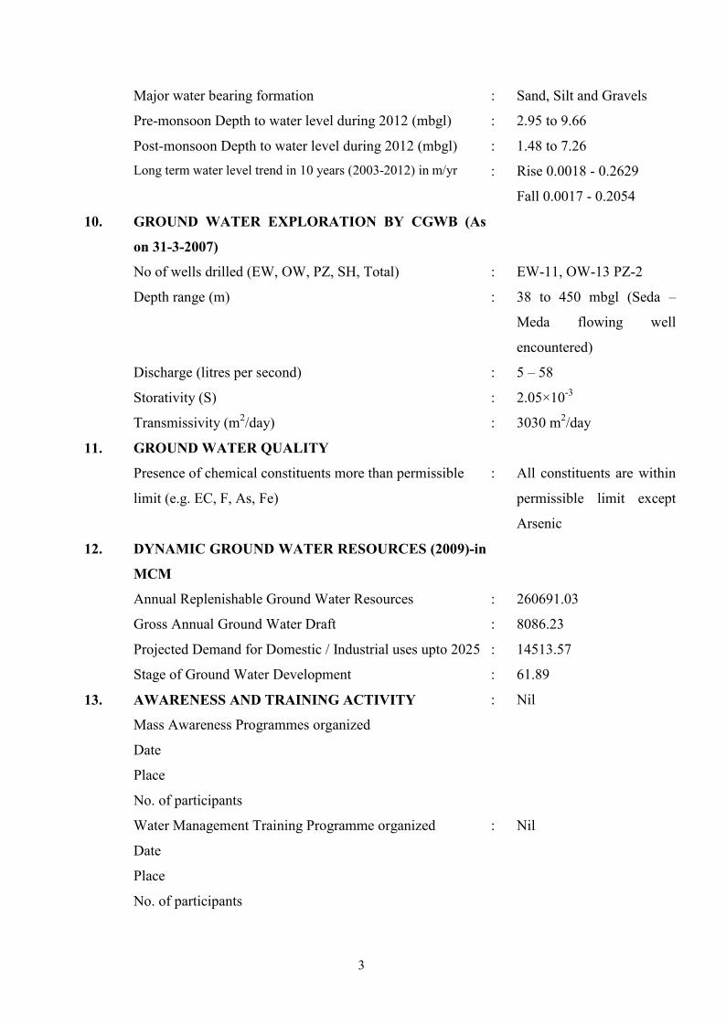
8
Sl. No. Type of Structure Number Depth Range(mbgl)
Yield(lpm)
1. Dugwells 168 4.50 – 10.90 -
2. State Tubewells 713 100.0 – 150.0 200 – 500
3. Borewells 108430 15.0 – 35.0 150 - 250
The area irrigated by canal is 641 Km. Drinking water tubewells have been
constructed by Central Ground Water Board under exploration programme in town
area and villages. Depth of drinking water tubewell varies from 227 to 331 mbgl. The
yield of the tubewells varies from 250 to 3480 lpm. One flowing well have been
observed at Seda – Meda. Total drilling depth of this tubewell was 450 mbgl.
V. GROUND WATER MANAGEMENT STRATEGY
5.1 Ground Water Development:
The stage of ground water development in the district is 61.89%. The
maximum stage of ground water development is in Ramaiya Behr block that is
88.13%. munimum ground water development have been observed at Gola block that
is 77.66%. All 15 blocks of this district are in safe category and have good scope for
further ground water development.
It is advisable to plan heavy duty tubewells, in future, for domestic, irrigation
and industrial uses. By exploiting these aquifers in order to reduce the overstress on
shallow aquifers occurring down to depth of 150 mbgl. Depending upon the position
of aquifer, the recommended drilling depth of heavy duty deep tubewells for different
regions are given below:
(i) Trans Sharda Tract : 450 mbgl
(ii) Extreme North Tract : 500 mbgl.
along Mohan river (to know the depth of autoflow condition
of aquifer by way of constructing
exploratory tubewells)

9
5.2 Water Conservation Structure and Artificial Recharge:
In the blocks where the ground water development is nearly 80% viz. Behjam,
Dhaurahara and Gola, the exploitation of ground water should be minimized and
practice of the conjunctive use of ground water and surface water should be adopted.
To conserve the ground water resources, drip sprinkler irrigation and change in
cropping pattern will be useful beside the artificial recharge of ground water
reservoirs.
VI. GROUND WATER RELATED ISSUE AND PROBLEMS
6.1 Risk to Natural Disaster:
The district lies in the belt of Arsenic affected area. The Arsenic concentration
is >10 ppb have been recorded in blocks Palia, Nighasan, Ramia Bihar, Dhaurahara
and Issanagar of district Lakhimpur. Further deep ground water exploration
iscompleted.Following tube wells have been constructed and handed over to U.P.Jal
Nigam for drinking water supply to the affected area-. The tube wells are:
1.Palia
2. Nighasan
3.Ramia Bihar
4.Dahruhra
5.Issanagar (Plate 07)
VII. MASS AWARENESS PROGRAMME
Recent by one programme will be conducted by CGWB in March 2009.

10

11

12

13

14

15

16


![[XLS] · Web viewBarabanki Gorakhpur Deoria Maharajganj Kushinagar Jhansi Jalaun Lalitpur Kanpur Nagar Auraiya Etawah Kannauj Farrukhabad Lucknow Lakhimpur Kheri Raebareli Sitapur](https://img.dokumen.tips/doc/110x75/5aabcf017f8b9ac55c8c5737/xls-viewbarabanki-gorakhpur-deoria-maharajganj-kushinagar-jhansi-jalaun-lalitpur.jpg)