Embed Size (px)
Citation preview

9GROUND TRANSPORT PLAN
159

9.1 IntroductionAs Adelaide Airport grows, it is critical that adequate consideration be given to future ground transport demands within and adjacent the airport. Accordingly, the Ground Transport Plan (GTP) has been prepared to reviewexistingtraffic,accessandparkingconditions associated with the airport andidentifieskeytransportinfrastructurestrategies. The GTP focuses on the next five-yearperiod(2014–2019),however,includes consideration of medium-term transport requirements up until 2034.
The primary objectives of the GTP are to:• identify the existing ground transport infrastructure
associated with the airport;• identify existing ground transport limitations and forecast
future ground transport demands;• identify transport initiatives and actions to accommodate
the forecast increases in ground transport demands and future growth of the airport; and
• address the requirements of the Airports Act 1996.
The GTP addresses the requirements of the Act as it details the following:• a road network plan;• the facilities for moving people (employees, passengers
and other airport users) and freight at the airport;• the linkages between those facilities, the road network and
public transport system at the airport, and the road network and public transport system outside of Adelaide Airport;
• the arrangements for working with the State or local authorities or other bodies responsible for the road network and the public transport system;
• the capacity of the ground transport system at the airport to support operations and other activities at the airport; and
• thelikelyeffectoftheproposeddevelopmentsintheMasterPlanonthegroundtransportsystemandtrafficflowsat,andadjacent,theairportsite.
9.2 BackgroundAccess StudyA detailed Adelaide Airport Access Study was prepared by Murray F Young and Associates (MFY) in 2007, with this Access Study forming the basis of the Surface Access Plan in the Adelaide Airport Master Plan (2009) and which has now been updated for the preparation of this Ground Transport Plan.
The previous study detailed access and infrastructure requirements to accommodate future growth in passenger demands and development opportunities within the airport site, with allowance given toward airport developments for over 20 years. As noted in the Surface Access Plan Section of the previous Master Plan “airport developments did not createintenseadditionaltrafficloadingontheroadnetworks,with often peak demand on the arterial roads being at differenttimestotheactivityoccurringatAdelaideAirportinterms of retailing uses and aviation scheduling”.
Since the preparation of the Adelaide Airport Access Study (2007), a number of the developments proposed have been realised, while others have not been undertaken. Table 9.1 summarises the development opportunities reviewed in the Access Study (2007) and provides an update on the status of each proposal.
The Adelaide Airport Access Study (2007)identifieda number of road network infrastructure upgrades to accommodate the developments outlined in Table 9.1, with the progress of the various recommendations included in the following Table 9.2.
GROUND TRANSPORT PLAN
160

Table 9.1 Development Proposals Considered in the Adelaide Airport Access Study (2007)
Table 9.2 Transport Infrastructure Recommendations Identified in the Adelaide Airport Access Study (2007)
Development Current statusStage 1 – Terminals & Business and Burbridge PrecinctVacant land east of Sir Richard Williams Avenue (expansion of Export Park) Partially developedIKEA and Masters bulky goods developments CompletedBurbridge Business Park Partially developedStage 2 – Tapleys and West Beach (Formerly Patawalonga) PrecinctsHarbourTownexpansion–twostages–7,500m²additionalfloorarea for retail brand outlet stores and supermarket Completed
Tapleys North Precinct – bulky goods and possible retail or service trade Not yet developedStage 3 – Airport East and Morphett PrecinctsAirfreightanddistributionactivitiesupto16,000m²intheAirportEastPrecinct Not yet developed
Generalindustrydevelopmenttotallingupto30,000m²intheMorphettPrecinct Partially developed (Manuele Engineering)
Intersection/road section
Upgrade requirements Planning Criteria
Expected Timing
Current status
Stage 1 – Airport access requirements to/from Sir Donald Bradman Drive (north of the Airport)Sir Donald Bradman Drive/ AQIS (left-in/left-out access) Left-in/left-out access for AQIS Commercial
Development 2003 Completed 2003
Sir Donald Bradman Drive/Sir Hubert Wilkins Avenue/Fred Custance Street
Construct new signalised intersection including two eastbound approach lanes and three westbound approach lanes
Commercial Development 2004 Completed
2004
Sir Donald Bradman Drive/ Vimy Avenue (left-in/ left-out access to/from Burbridge Business Park)
Construct new left-in/ left-out (unsignalised) intersection to service Burbridge Business Park
Commercial Development 2004 Completed
2004
Sir Donald Bradman Drive/ IKEA dedicated access
Convert existing left-in/ left-out access to warehouse to signalised intersection for IKEA
Commercial Development 2006 Completed
2006Sir Donald Bradman Drive/Sir Richard Williams Avenue/Airport Road (signalised intersection)
Create an extra westbound lane on Sir Donald Bradman Drive
National Land Transport Network 2007 Not
undertaken
Create separate through and right-turn lanes on Sir Richard Williams Avenue
National Land Transport Network 2009 Not
undertakenCreate an additional through and right-turn lane from Airport Road
National Land Transport Network 2011 Not
undertakenAt-grade option – provide an additional eastbound through lane on Sir Donald Bradman Drive
National Land Transport Network 2016 Future need
At-grade option – alter phasing to diamond overlap by realigning right-turn lanes on Airport Road and Sir Richard Williams Avenue
National Land Transport Network 2018 Future need
– Add second right-turn lane from Sir Donald Bradman Drive to Sir Richard Williams Avenue or alternate overpass option
National Land Transport Network 2021 Future need
161
ADELAIDE AIRPORT 2014 MASTER PLAN

Intersection/road section
Upgrade requirements Planning Criteria
Expected Timing
Current status
Stage 2 – Airport access requirements to/from Tapleys Hill Road (west of the Airport)
Tapleys Hill Road between Burbridge Road and Ingerson Avenue
No access to Tapleys Hill Road Recreational Development N/A Complied
with in 2007.
Tapleys Hill Road/ West Beach Road/ Sir Reginald Ansett Drive (signalised intersection)
Upgradesignificantlyviatheprovision of extra lanes, and signal variations
Retail Revelopment 2009
Upgrades undertaken on Sir Reginald Ansett Drive approach with new slip lane extension in 2013. Any further airport works related to expanded on-airport retail.
New access point to the Tapleys North Precinct
Provide a left-in/left-out access to the north of the existing intersection
Retail Development
New Development initiated
Not undertaken (associated development has not occurred).
9. GROUND TRANSPORT PLAN
162

Intersection/road section
Upgrade requirements Planning Criteria
Expected Timing
Current status
Stage 3 – Airport access requirements to/from the eastern and southern sides of the Airport
Richmond Road to Terminals Precinct, including Richmond Road / Marion Road Intersection
Feasibility assessment to identify the viability of a controlled access for taxis, buses or commercial vehicles only or for all vehicles
State Integrated Transport & Land
Use StudyN/A
Adopted as a surface transport recommendation in the 2009 Master Plan and retained in this Master Plan.
Morphett Road Provide access to the Morphett Precinct Commercial Development 2009
Access adjacent Manuele Engineering completed in 2009.
James Melrose Road (or Mooringe Avenue)
Upgrade and/or maintain collector road(s) and subsequent intersections (e.g. Marion Road/Mooringe Avenue) to accommodate B Double vehicles
Local Operations Notspecified Not undertaken.
Morphett Road link to Richmond Road (Southern Collector)
Provide future allowance for B-Double corridor from Morphett Road to Richmond Road, possibly through Netley Commercial Park
State 30-Year Plan for Greater
Adelaide and State
Infrastructure Plan
10 year prospect
Not undertaken, but road corridor reservation maintained on airport land.
On the basis of the above table, it can be seen that the recommended upgrade requirements for commercial airport developments have been met, except where the envisaged development has not transpired. Continued growth in general trafficwillplaceincreasedpressureontheexternalgroundtransport network, with this now recognised in the State Government Integrated Transport and Land Use Plan, 2013, with major intersections linking Adelaide Airport to the City identifiedforupgrading,andRichmondRoadconnectivityproposed for Taxi, Bus and controlled vehicle access into Adelaide Airport.
163
ADELAIDE AIRPORT 2014 MASTER PLAN

9.3 Existing Ground Transport Infrastructure9.3.1 External Road NetworkSir Donald Bradman Drive and Tapleys Hill Road are dual lane, separate carriageway, major arterial roads under the control of the State Government’s Department of Planning, Transport and Infrastructure. James Melrose Road and Warren Avenue are both collector roads under the care and controloftheCityofWestTorrens,comprisingsingletrafficlanes in each direction.
Military Road is a collector road under the care and control of the City of Charles Sturt (northern section) and City of West Torrens (southern section). Similarly, West Beach Road is a collector road under the care and control of the City of Charles Sturt, for the western section, and the City of West Torrens, for the eastern section. Both roads comprise a singletrafficlaneineachdirectionseparatedbyapaintedcentreline. A service road is also provided parallel to West Beach Road which provides parking and access for adjacent sites to the south.
Access arrangements for the various updated precincts via the external road network are as follows:• Runways Precinct
• secure airside area accessed via controlled access points; and
• a number of secured emergency only access points around the perimeter of the site.
• Terminals & Business Precinct• the primary access for the overall Airport site is provided
via the Sir Donald Bradman Drive/Airport Road/Sir Richard Williams Avenue signalised intersection;
• a secondary signalised access provided for the IKEA/MASTERS development on Sir Donald Bradman Drive;
• a minor access (left-in/left-out) to the Department of Agriculture building on Sir Donald Bradman Drive;
• an access provided via the signalised intersection of Sir Donald Bradman Drive/Fred Custance Street; and
• an access provided via the unsignalised intersection of Sir Donald Bradman Drive/Vimy Avenue (left-in/left-out).
• Torrens Precinct• access points provided via the Burbridge Road service
road, Ingerson Avenue and Foreman Street.
• Tapleys Precinct• an access provided via the signalised intersection
of Tapleys Hill Road/West Beach Road/Sir Reginald Ansett Drive (at the northern end of the Harbour Town development); and
• a left-in/left-out/right-in unsignalised access (at the southern end of the Harbour Town development).
• West Beach Precinct• four currently gated access points on West Beach Road
(or its service road); and• indirect access to the golf course via the adjacent
Adelaide Shores property access points.• Morphett Precinct
• fiveaccesspoints(fourofwhicharegated)onJamesMelrose Road, including the access for the Manuele Engineers development; and
• a secure access on the continuation of Morphett Road (currently providing controlled and emergency only access to the airside area).
• Airport East Precinct• a number of access points are provided to individual
developments within the Airport East Precinct including access points along Transport Avenue, Richmond Road and Morley Street.
Figure9.1depictstherespectiveexistingtrafficmovementsonthe various major roads surrounding the airport and internally along Sir Richard Williams Avenue as at March 2014. The trafficcountshavebeenderivedbytheStateGovernmentDepartment of Planning, Transport and Infrastructure, and are subject to regular updating during each year.
Figure 9.2 illustrates the locations of the existing and future key access points for the airport site.
9. GROUND TRANSPORT PLAN
164

Figure 9.1 Average Annual Daily Total Traffic Estimates of Major Roads surrounding Adelaide Airport 165
ADELAIDE AIRPORT 2014 MASTER PLAN

9.3.2 Internal Road Network(a) Runways Precinct A network of secure internal access roads extending for
over 23 kilometres is provided within the Runways Precinct for airside access. Public access to the airside roads is restricted.
(b) Terminals & Business Precinct The majority of Adelaide Airport’s internal road network of
around 16 kilometres is provided within the Terminals & Business Precinct. Sir Richard Williams Avenue provides the primary access connection between the external road network and T1. This network accommodates movements to/from the passenger set-down/pick-up facility, short-stay andlong-staycarparks,staffcarparks,carhirecollection/drop-offandthetaxiholdingarea.
Sir Richard Williams Avenue comprises a two-way dual lane separated carriageway between Sir Donald BradmanDriveandJamesSchofieldDrive.
BetweenJamesSchofieldDriveandtheWesternLinkRoad, Sir Richard Williams Avenue separates to provide a one-way passenger set-down/pick-up facility (underneath the multi-level short-stay car park) and ingress/ egress lanes to the multi-level car park. South-west of the Western Link Road, Sir Richard Williams Avenue forms a one-way(duallane)looparoundthestaffandlong-stayparking areas.
The passenger set-down/pick-up facility for the Terminaliscomprisedoftwotrafficlanesandashort-term standing lane. Approximately 20 to 25 vehicles can be accommodated in the parking lane. The facility accommodates set-down/pick-up by domestic vehicles as well as set-down of passengers arriving by taxi. Taxi pick-up is accommodated via a separate facility to the south of the short-stay car park building.
WesternLinkRoadandJamesSchofieldDrivecompletethe primary access route for passenger movements entering and exiting the site via the main access point.
Both roads provide dual lane carriageways separated by central medians. Roundabouts are provided at the intersections of the three primary internal roads to safely andefficientlyaccommodatevehiclemovements.
Sir Hubert Wilkins Avenue provides a secondary access route for drivers travelling between the secondary signalised intersection on Sir Donald Bradman Drive and the Terminals & Business Precinct. The road also provides access for the current car hire storage facilities and a link between the Terminals & Aviation Policy Area and the Burbridge Business Park Policy Area via Fred Custance Street.
Both Sir Hubert Wilkins Avenue and Fred Custance Streetcomprisesingletrafficlanesineachdirectionseparated by line-marked centrelines, except at the intersection with Sir Donald Bradman Drive where additional turn lanes are provided.
A partially completed loop road (Butler Boulevard) and Vimy Avenue form a central link through the western side of the Terminals & Business Precinct to Sir Donald Bradman Drive. These roads generally comprise wide carriageways (to accommodate large commercial vehicles including B-Doubles) with single lanes in each direction. The northern intersection of Vimy Avenue and Butler Boulevard forms a four-way intersection which is controlled by a roundabout.
Additional minor internal roads are provided throughout the Terminals & Business Precinct which provides access for individual developments and airport related activities.
(c) Torrens Precinct The Torrens Precinct is largely undeveloped, with the
only internal access road provided for access to/from the Adelaide University hockey grounds (via Burbridge Road) and direct access into the aged-care facility.
(d) Tapleys Precinct Sir Reginald Ansett Drive provides access for the Tapleys
Precinct (including the Harbour Town Shopping Centre and aviation support developments).
(e) West Beach Precinct The West Beach Precinct has limited internal access
provision (limited to minor maintenance roadways). Access to/from the precinct is general provided via adjacent public roads, namely West Beach Road, Military Road and Tapleys Hill Road.
(f) Morphett Precinct Internal roads within the Morphett Precinct are limited
to individual property access points for the few existing developments within the Precinct.
(g) Airport East Precinct Internal roads within the Airport East Precinct are limited
to individual property access points for the existing developments within the Precinct, with the exception of the extension of Transport Avenue (at its south-western end).
9. GROUND TRANSPORT PLAN
166

Figu
re 9
.2 A
dela
ide
Airp
ort a
cces
s po
ints
167
ADELAIDE AIRPORT 2014 MASTER PLAN

9.3.3 ParkingA substantial extent of car parking is provided across the Adelaide Airport site. Parking provision for airport operations includesshort-stay,long-stayandstaffparkingandGeneralAviation Terminal car parking.
Short-stay parking is provided within a multi-level car park located to the north-west of T1 and accessed via Sir Richard Williams Avenue. The short-stay car park contains 1,640 parking spaces provided over four levels. Ingress and egress movements are controlled by boom gates associated with paid parking controls.
Long-stay parking is provided adjacent the south-western end of Sir Richard Williams Avenue. Access to the long-stay car parking area is controlled by boom gate facilities. A total of 2,020 spaces are provided for long-stay parking as at 2014. Passengers utilising the long-stay parking facilities can access the Terminal via the shuttle bus service or walk approximately 400 metres. In addition to the onsite long-stay parking facilities,off-siteoperatorsalsoprovidelong-stayparkingfacilities with associated shuttle bus facilities.
StaffparkingisprovidedintwoparkingareaswithintheTerminals&BusinessPrecinct.Thefirstcarparkcontains 595 parking spaces and is located at the south-western end of Sir Richard Williams Avenue (to the east of the long-stay carpark).Thesecondstaffcarparkislocatedtothenorth of the short-stay car park and contains 310 spaces.
Figure 9.3 illustrates the locations of the current 2014 key parking facilities within the Terminals & Business Precinct.
Parking for vehicles associated with development sites and airport support services are provided within individual parking areas associated with each land use.
Figure 9.3 Primary parking facilities within the Terminals & Business Precinct (Source: Murray F Young and Associates, 2014)
9. GROUND TRANSPORT PLAN
168

9.3.4 Public TransportPublic transport access to and from Adelaide Airport is currently limited to bus services. Presently six bus routes regularly service the airport, namely:• Route J1 – Glenelg interchange to City;• Route J1A – City to Adelaide Airport;• Route J2 – Harbour Town Centre interchange to City;• Route J7 and J8 – West Lakes Centre interchange to
Marion Centre interchange; and• Route 300 – Suburban Connector (ring route) including
servicing of Harbour Town interchange.
Buses operating on the above routes (with the exception of Route 300) utilise Sir Richard Williams Avenue to provide access to and from the Terminals & Business Precinct with 3 bus stops strategically sited for ready commuter accessibility. Buses servicing routes 300, J1, J1A and J2 also enter the Harbour Town Centre interchange via Reginald Ansett Drive.
In addition to the above routes (which enter the Airport site), Route 162 operates between West Beach and the City via Sir Donald Bradman Drive and is utilised for access to the Terminals & Business Precinct by some airport users.
Routes 167 and 168 provide access to the south-east of the Airport site along Mooringe Avenue and Marion Road. These routes could be utilised by users associated with the Airport East and Morphett Precincts.
Figure 9.4 illustrates the current routes utilised by the services detailed above as at February 2014. These are subject to ongoing revision from time to time by DPTI.
Figure 9.4 Public Transport Network Map (Source: Adelaide Metro, January 2014) 169
ADELAIDE AIRPORT 2014 MASTER PLAN

9.3.5 Taxis/Limousine/Tour BusesTaxi services are a key component of the ground transport system and accommodate a large proportion of passenger access demands for Adelaide Airport. Taxi services operate withintheTerminals&BusinessPrecinctunderaspecificarrangement overseen by the South Australian Taxi Council. Facilitiesincludeataxilay-offarea(withcurrentcapacityforapproximately 350 vehicles and an associated driver amenity facility) and a passenger loading (pick-up) rank including concierge service (with capacity for approximately 45 taxis). Taxipassengerdrop-offisaccommodatedwithinthegeneralpassenger set-down/pick-up underneath the short-stay car park building, with a possible dedicated set down facility to the northern end of the Terminal Plaza under evaluation in 2014/15. Similarly, limousine car parking adjoins the taxi holding areas as do facilities for Tourist Buses.
9.3.6 Car Hire and Valet ServicesCar rental facilities are provided within the Terminals & BusinessPrecinct.Thefacilitiesincludeserviceofficeswithinthegroundfloorofthemulti-levelcarparkandkioskswithinTerminal1.Rentalcarsarecollectedanddroppedoffbycustomers at the ground level of the multi-level car park. Additional car storage facilities are provided for the rental companies along Sir Hubert Wilkins Avenue.
Qantas operates a valet service for customers’ cars at Adelaide Airport with 50 parking spaces and a valet kiosk at the southern side of the Terminal building. Longer term storage for valet cars is provided in a secure compound fronting Sir Hubert Wilkins Avenue.
9.3.7 Walking and CyclingPedestrian paths connect Terminal 1 with the set-down/ pick-up,short-stay,long-stayandstaffparkingareas.Additional paths are also provided along Sir Richard Williams Avenue to accommodate pedestrian movements to and from the external road network.
On-road bicycle lanes are provided on Sir Donald Bradman Drive along the frontage of the airport site. The following shared (pedestrian and cyclist) paths are also provided adjacent the Airport:• the Anna Meares Bike Path – which extends along Sir
Donald Bradman Drive, between Tapleys Hill Road and Frank Collopy Court;
• the Reece Jennings Bikeway – which extends along Tapleys Hill Road, between Anderson Avenue (south of the airport) and the River Torrens Linear Park shared path (north of the airport); and
• the Captain McKenna Shared Use Pathway – which extends along the airport’s southern boundary, between Warren Avenue and Lew Street/Watson Avenue.
Internal cyclist movements within the Airport Precincts are shared within the road carriageways. Figure 9.5 illustrates the major transport routes, including the cycling network, surrounding the airport site.
Parking for bicycles is currently accommodated in a free facility onthegroundfloorofthemulti-levelcarpark.Thebicycleparking is being utilised for passengers and employees and there is capacity to expand the facility as demand warrants.
9.3.8 Commercial Development OpportunitiesThe commercial development opportunities within Adelaide Airport remain consistent with the previous potential yields reviewed as part of the Adelaide Airport Access Study (2007) with the exception of the expanded portion of the Morphett Precinct to the northern side of the Keswick/Brownhill Creek drainage easement. A number of the developments reviewed as part of the 2007 study have since been undertaken and, as noted above, associated road infrastructure upgrades (where the responsibility of AAL) have been completed. In some precincts, development opportunities compared to the previous assumptions may be ofalowerscale,sothatthetrafficdemandislessintensivethan the conservative estimates used for the previous Adelaide Airport Access Study (2007) and updated in 2013.
The following potential commercial development uses (excluding airport facilities and service industries) have been identifiedwithinthevariousprecincts:• Terminals & Business Precinct – hotel/conference facilities,
officesandhardwareretail.• Torrens Precinct – recreational use and aged care facilities.• Tapleys Precinct – expanded retail, bespoke commercial
uses and industrial/ aviation support uses.• West Beach Precinct – bespoke commercial uses and
tourist/recreation facilities (associated with Adelaide Shores).• Morphett Precinct – transport/logistics facilities, industrial
and commercial uses.• Airport East Precinct – transport/logistics facilities, industrial
uses and alternate aviation-related support industry.
9. GROUND TRANSPORT PLAN
170

9.3.9 Freight and LogisticsAdelaide Airport is an important freight hub within Adelaide and South Australia. Freight and logistics operators are primarily located within the Terminals & Business and Airport East Precincts. A number of freight and logistics businesses operate with secure airside access.
Freight and logistics operators generate higher demands for the use of commercial vehicles compared with other uses utilising the internal landside and external road networks. This includes heavy rigid trucks, semi-trailer and B-Double vehicles.
Access by B-Double vehicles is accommodated to/from a number of the airport precincts by gazetted routes. On the adjacent arterial road network, Sir Donald Bradman Drive, Tapleys Hill Road and Richmond Road are gazetted B-Double routes. A number of roads within the airport site are also gazetted for B-Double operation, including Sir Richard WilliamsAvenue,JamesSchofieldDriveandanumberassociated with Export Park and Burbridge Business Park. Figure 9.5 illustrates the gazetted B-Double road network surrounding and within the airport site.
Figure 9.5 Transport Corridor Routes Surrounding Adelaide Airport
171
ADELAIDE AIRPORT 2014 MASTER PLAN

9.4 Ground Transport DemandsGround transport demands for airports depend on a variety of factors, including (but not limited to) mode availability, cost, traveltimesandtrippurpose.Differentusergroupswillplacevarying importance on the factors when assessing appropriate modes. For instance, mode reliability is a primary concern for passengers(toreachflightson-time),however,itwouldbealesserfactorforAdelaideAirportstaff.
In order to assess the adequacy of the existing road networks and consider appropriate improvements as further airport growthoccurs,identificationofexistinggroundtransportdemandsisrequired.Thefollowingtrafficvolumedatawasobtained to assist in preparing the GTP:• The 2013 vehicle turning volume data (Sydney Coordinated
AdaptiveTrafficSystem(SCATS)signalcontroller)forweekday peak periods (am and pm) were provided by DPTI for the following intersections:� Sir Donald Bradman Drive/Sir Richard Williams Avenue/
Airport Road intersection.� Sir Donald Bradman Drive/Tapleys Hill Road
intersection.� Tapleys Hill Road/West Beach Road/Sir Reginald Ansett
Drive.� Sir Donald Bradman Drive/Marion Road.� Marion Road/Richmond Road.
• Queuing and delay surveys were undertaken in May 2013 at the Sir Donald Bradman Drive/Airport Road/Sir Richard Williams Avenue and Sir Donald Bradman Drive/MarionRoadintersectionsduringthedifferentpeakperiodsassociatedwithairporttrafficandprimarilypassingcommutertraffic.
• The forecast turning counts for 2036 were prepared by DPTI for the road network surrounding the Airport. These forecast volumes include projected growth on the road network associated with any growth at Terminal 1 and existing land uses.
Inadditiontothetrafficvolumedata,thefollowingadditionalinformation relating to transport modes was collated:• airport data identifying the daily and hourly breakdowns of
taxi movements within the holding and pick-up areas;• DPTI’s Public Transport Services Division data identifying
patronage associated with bus routes servicing the airport;• airport data identifying daily short-stay and long-stay
parking demands; and• surveydatacollatedbyMFYidentifyingtheclassificationof
vehicle types utilising the set-down/pick-up area (i.e. domestic
vehicles, taxis, shuttle buses, public transport buses etc.).
Based on a review of available ground transport demand data, Figure9.6illustratestheproportionofaveragedailytrafficdemands associated with user types within the overall airport site as well as the Terminals & Aviation Policy Area. In both instances, movements associated with airport passengers comprise the largest user group.
Figure 9.6 Traffic Demands by user type for the overall site and for the Terminals and Aviation Policy Area only (Source: Murray F Young and Associates, 2013)
Overall Airport Site
Terminals Policy Area Only
10% Commercial,
Development, Freight and Logistics
30%Commercial,
Development, Freight and Logistics
56% Passenger
34% Staff
44%Passenger
26% Staff
9. GROUND TRANSPORT PLAN
172
Passenger GrowthThe movement of passengers to, from and within Adelaide Airport is a primary consideration of the GTP. Data currently indicates that approximately 7.56 million passengers per annum use ground transport to gain access to/from the airport with this number forecast to grow to 18.4 million passengers by 2034. Such increases in passenger numbers willgeneratesignificantincreasesintrafficmovementsandparking demands within and adjacent the airport. Figure 9.6 illustrates the projected increases in average annual passenger numbers to 2034.
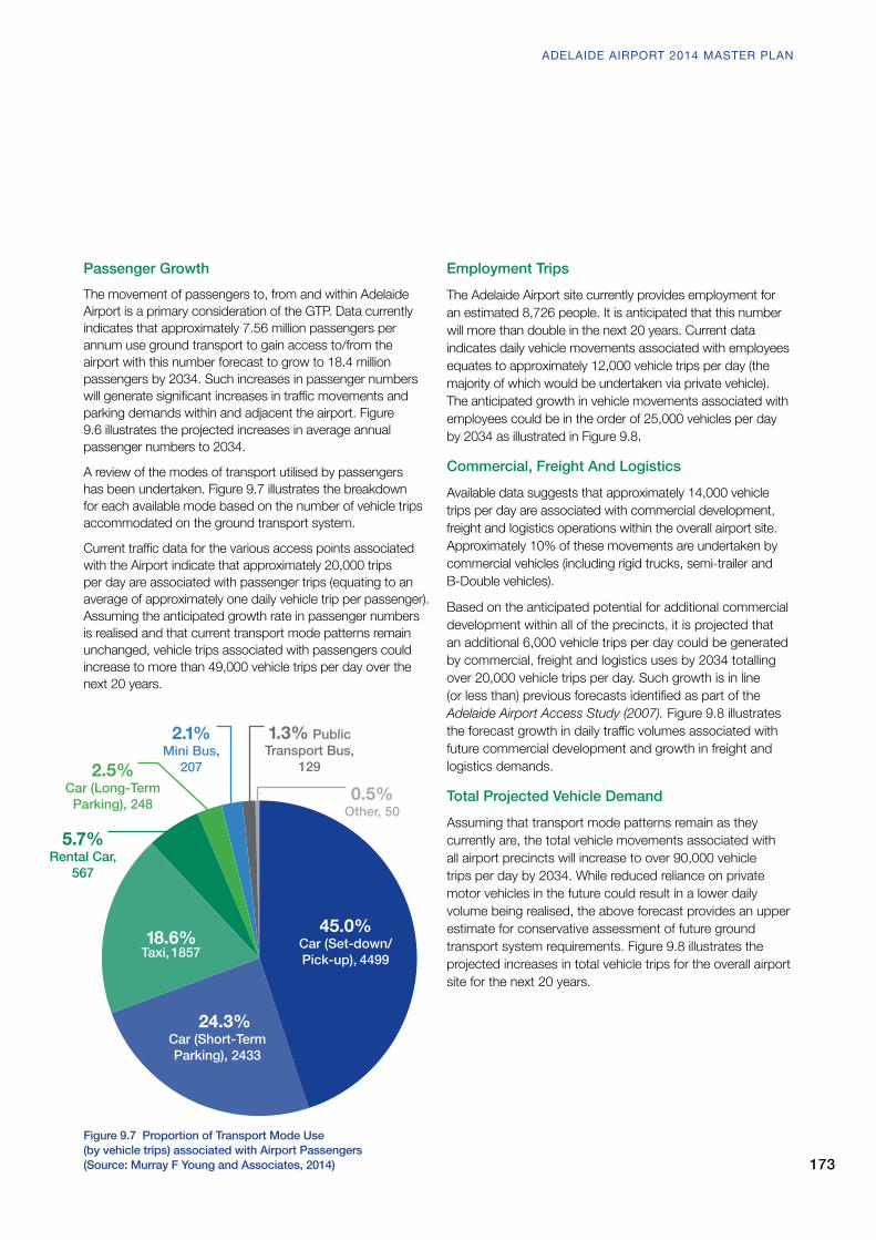
A review of the modes of transport utilised by passengers has been undertaken. Figure 9.7 illustrates the breakdown for each available mode based on the number of vehicle trips accommodated on the ground transport system.
Currenttrafficdataforthevariousaccesspointsassociatedwith the Airport indicate that approximately 20,000 trips per day are associated with passenger trips (equating to an average of approximately one daily vehicle trip per passenger). Assuming the anticipated growth rate in passenger numbers is realised and that current transport mode patterns remain unchanged, vehicle trips associated with passengers could increase to more than 49,000 vehicle trips per day over the next 20 years.
Employment TripsThe Adelaide Airport site currently provides employment for an estimated 8,726 people. It is anticipated that this number will more than double in the next 20 years. Current data indicates daily vehicle movements associated with employees equates to approximately 12,000 vehicle trips per day (the majority of which would be undertaken via private vehicle). The anticipated growth in vehicle movements associated with employees could be in the order of 25,000 vehicles per day by 2034 as illustrated in Figure 9.8.
Commercial, Freight And LogisticsAvailable data suggests that approximately 14,000 vehicle trips per day are associated with commercial development, freight and logistics operations within the overall airport site. Approximately 10% of these movements are undertaken by commercial vehicles (including rigid trucks, semi-trailer and B-Double vehicles).
Based on the anticipated potential for additional commercial development within all of the precincts, it is projected that an additional 6,000 vehicle trips per day could be generated by commercial, freight and logistics uses by 2034 totalling over 20,000 vehicle trips per day. Such growth is in line (orlessthan)previousforecastsidentifiedaspartoftheAdelaide Airport Access Study (2007). Figure 9.8 illustrates theforecastgrowthindailytrafficvolumesassociatedwithfuture commercial development and growth in freight and logistics demands.
Total Projected Vehicle DemandAssuming that transport mode patterns remain as they currently are, the total vehicle movements associated with all airport precincts will increase to over 90,000 vehicle trips per day by 2034. While reduced reliance on private motor vehicles in the future could result in a lower daily volume being realised, the above forecast provides an upper estimate for conservative assessment of future ground transport system requirements. Figure 9.8 illustrates the projected increases in total vehicle trips for the overall airport site for the next 20 years.
Figure 9.7 Proportion of Transport Mode Use (by vehicle trips) associated with Airport Passengers (Source: Murray F Young and Associates, 2014)
45.0%
Car (Set-down/Pick-up), 4499
24.3% Car (Short-Term Parking), 2433
18.6% Taxi, 1857
5.7% Rental Car,
567
2.1%Mini Bus,
207
0.5% Other, 50
2.5% Car (Long-Term
Parking), 248
1.3% Public Transport Bus,
129
173
ADELAIDE AIRPORT 2014 MASTER PLAN

Figure 9.8 Proportion of Transport Mode Use – Overall Airport (Source: Murray F Young and Associates, 2014)
2013
2014
2015
2016
2017
2018
2019
2020
2021
2022
2023
2024
2025
2026
2027
2028
2029
2030
2031
2032
2033
2034
Tota
l Dai
ly V
ehic
le M
ovem
ents
Year
10,000
30,000
20,000
50,000
40,000
70,000
60,000
90,000
100,000
80,000
Passenger Staff Commercial, Development, Freight & Logistics
9.5 Future Ground Transport InfrastructureIn order to accommodate future growth associated with increased passenger demands and future development opportunities within the airport, upgrades will be required to the ground transport network. Key intersections on the adjacent external road network will require upgrade to accommodate additional movements associated with the airport as well as general non airport related growth on the external road network. The internal road networkwillrequiresignificantrealignmentand upgrade to adequately accommodate future ground transport demands.
9.5.1 External Road NetworkA number of upgrades to the external airport road network identifiedaspartofthepreviousAdelaide Airport Access Study (2007) have not yet been undertaken due to funding constraints associated with the National Land Transport Networks. Such upgrades are required, particularly at peak times to accommodatenon-airportrelatedtrafficto/fromtheWesternSuburbs and existing and future aviation growth needs. Further technicalanalysishasidentifiedadditionalupgradeprospectsincluding those included in the draft Integrated Transport and Land Use Plan (2013). These include:-
9. GROUND TRANSPORT PLAN
174

(1) Sir Donald Bradman Drive / Sir Richard Williams Avenue / Airport RoadAsidentifiedinTable9.2,thisprimaryaccessintersection into the airport, which forms part of the National Land TransportNetwork,continuestorequiresignificantalterationstomeetpeaktrafficdemand.Thisrequirementisrecognisedin the State draft Integrated Transport and Land Use Plan (ITLUP),whichidentifiesthatallmajorintersectionsalong Sir Donald Bradman Drive are to be upgraded in the short to mediumterm.Inaddition,theITLUPalsoidentifiesthefutureallowance for a light rail spur to enter the airport from Airport Road, which will need to be considered against the various intersection alterations.
(2) Sir Donald Bradman Drive / Sir Hubert Wilkins AvenueAs outlined in the Airport Master Plan (2009), the current assessment of future ground transport demands has supported the need for a second major access to service the Terminals & Business Precinct to minimise upgrade requirements at the existing primary access point at Sir Donald Bradman Drive / Sir Richard Williams Avenue. Opportunities to provide a second major access for the airport are constrained. However, for the short-to-medium-term, it hasbeenidentifiedthattheupgradeofSirDonaldBradmanDrive/Sir Hubert Wilkins Avenue intersection (along with internal road alterations detailed below) will accommodate the provision of a second terminal access. The intersection upgrade comprises an additional right-turn lane on Sir Donald Bradman Drive and internal alterations to increase queuing distances and remove the internal intersection immediately adjacent the access.
(3) Richmond / Marion Roads – Airport LinkAs included in the State draft Integrated Transport and Land Use Plan (2013) the transfer of taxis, buses and controlled commercial vehicles through a new route along Richmond Road and extending to the Export Park Policy Area of the airportwilllowertrafficdemandsusingSirDonaldBradmanDrive and entering along Sir Richard Williams Avenue. This will entail improvements to the Marion Road / Richmond Roadintersection(whichwasidentifiedasbeingatcapacityin the aforementioned Adelaide Airport Access Study 2007), possible enhancements along Richmond Road and the development of a new link roadway from Richmond Road abutting the Keswick Creek at West Richmond into the Export Park Policy Area.
(4) Morphett / Deeds Road to Richmond Road (Southern Collector Route)The State 30-Year Plan for Greater Adelaide included the provision of a new collector route adjacent the south eastern corner of the airport (between the Morphett and Airport East Precincts). This new route could connect though the Netley Commercial Park to Marion Road or alternatively via Richmond Road and emanating from either Morphett Road or Deeds Road, with the primary aim to cater for commercialtraffictoandfromCamdenPark/NorthPlympton. Airport developments and non-airport related feedertrafficusingthenewSouthernCollectorwillcontributetoincreasedtrafficonRichmondRoad.Reservationoflandfor this collector route within the airport continues to be maintained (refer Figure 9.5). The current study suggests greater functionality should the collector route have passage through the Netley Commercial Park, where a four way intersection at Desmond Avenue would require signalisation tosafelyandefficientlyaccommodatetrafficmovements.
Figure 9.9 Upgrade of Sir Donald Bradman Drive/Sir Hubert Wilkins Avenue Intersection to Provide Short to Medium-Term Second Major Terminal Access Point (Source: Murray F Young and Associates, 2014)
Kooyonga Golf Course
Airport
175
ADELAIDE AIRPORT 2014 MASTER PLAN

9.5.2 Internal Road NetworkIn order to accommodate the altered access arrangements on the surrounding external road network, a number of alterations to Adelaide Airport’s internal road network will be required.
New Taxi Access LinkIt is proposed to provide a new access connection from Airport East to the eastern side of the Terminal & Business Precinctwithinfiveyears.Theaccessroadwillallowanewroute for taxi movements into the airport from Richmond Road via the existing Richmond Road/Marion Road intersection. The State Government has included this alternative taxi access route for the airport within its draft Integrated Transport and Land Use Plan.
Access to the internal connection will be secured and provided for taxis, buses and controlled commercial vehicles (or other authorised airport vehicles). It will not provide a road connection for public access. Figure 9.10 illustrates the existing primary, secondary and alternate routes.
Realignment of Internal East-West Road ConnectionThe upgrade of Sir Donald Bradman Drive/Sir Hubert Wilkins Avenue intersection to provide the short-to-medium-term second terminal access will require realignment of adjacent internalroadswithinfiveyears.Thiswillincludethecreation of a new link road between the Terminals & Aviation and the Burbridge Business Park Policy Areas, and diversion of Sir Hubert Wilkins Avenue to provide a major internal connector route. The intersection of Sir Hubert Wilkins Avenue and the Terminal-Burbridge connector roadway would be controlled by a dual lane roundabout. The connection could also allow movements associated with a new long-stay parking facility in the Burbridge Business Park Policy Area. Figure 9.12 illustrates the possible concept alignment of the internal Terminals-Burbridge connector roadway in the longer term through a Western Link Road realignment.
Figure 9.10 Proposed Taxi Route and Holding Area and realignment of internal east-west road connection
9. GROUND TRANSPORT PLAN
176

Figure 9.11 Proposed East-West Link Road
Western Link Road RealignmentThe potential expansion of the short-stay car park will require alteration of the existing alignment of the southern end of the Western Link Road. Future design of an expanded Multi-Level Car Park will need to ensure adequate accommodation of vehicle movements in this area, including egress from the short-stay car park, the rental car facilities and the passenger set-down/pick-up facility. The realignment of the southern end of the Western Link Road is shown at Figure 9.11.
177
ADELAIDE AIRPORT 2014 MASTER PLAN

9.5.3 ParkingAdelaide Airport’s long-stay car parking facility currently operates near capacity. On occasion, both the short-stay and staffcarparksareutilisedtoaccommodateoverflowdemandfor passenger long-stay parking. Accordingly, there is a short-term need to provide additional long-stay parking capacity. Additionally, the current long-term facility is located within the area nominated for future terminal expansion. It is proposed to construct a new long-stay parking facility (with shuttle bus service) in the north-western corner of the Terminals & Business Precinct. Approximately 2,500 parking spaces will be required to accommodate long-stay parking demand growth over the next 5 years with up to 4,700 possibly requiredby2034(ifexistingtrafficdemandpatternsremain).
Theshort-staycarparkhassufficientcapacitytoaccommodate increased passenger short-term parking demandsforthenextfiveyears(particularlyonceoverflowlong-stay parking is accommodated elsewhere).
In the medium-term (6+ years), passenger demands for short-stay parking will exceed the current capacity and an expansion will be required. Consideration has been given to the extension of the existing multi-level car park to the south-west to double the existing supply of short-stay parking by 2020. Such an increase would accommodate demands for the 20-year horizon(ifexistingtrafficdemandpatternsremain).
Theexistingstaffparkingareasarelocatedwithintheareanominated for future terminal expansion and ancillary facilities. Itisproposedthatanadditionalstaffparkingfacilitybelocatedeither to the eastern side of the airport adjacent the proposed taxi link road or within the Burbridge Business Park Policy Area.
Figure9.12identifiesthepossiblelocationoftheexpandedand relocated parking facilities.
Figure 9.12 Possible Locations for Relocated and Expanded Parking Facilities
9. GROUND TRANSPORT PLAN
178

9.5.4 Public TransportFor the short-to-medium-term, public transport services associated with Adelaide Airport will be limited to public bus services.Thereiscurrentlysufficientcapacityonexistingservices to accommodate increased passenger demands for public transport in the medium-term.
In the longer term, it is desirable to encourage greater use of public transport as an access mode to/from the airport (forbothpassengersandstaff).TheStateGovernment’sdraft Integrated Transport and Land Use Planidentifies the future connection of light rail or tram services between the airport and Adelaide’s CBD a key outcome for the public transportnetwork.ThePlanidentifiesthetramroute along Airport Road and Henley Beach Road, which is illustrated at Figure 9.13 within the airport itself.
9.5.5 TaxisFuture growth in passenger numbers will result in increased numbers of taxis accessing Adelaide Airport. As noted above, it is proposed to construct a new taxi ingress route to address the impact of increased taxi movements. Future demand analysis indicates that (if existing transport demand patterns remain):• up to 450 spaces could be for taxi holding facilities with up
to 60 spaces required within the taxi pick-up area within the next 5-year period, with 100 spaces possibly necessary in an expanded taxi pick-up area by 2034; and
• Depending upon the level of public transport provision, ancillary taxi holding may be necessary, with a number of options available, including areas associated with the intended egress/ingress route from Richmond Road.
Figure 9.13 Potential Route for Future Tram Services to/from the Airport 179
ADELAIDE AIRPORT 2014 MASTER PLAN

9.5.6 Car Hire and Valet ServicesIncreased passengers will generate additional demand for car hire and valet services. Existing provisions are expected to be adequate within the short-term. However, future expansion of these facilities will be required in the medium-to-long-term. The future expansion of the multi-level car park will provide opportunity for provision of additional car hire and valet service facilities in close proximity to T1.
9.5.7 Walking and CyclingThe State Government’s draft Integrated Transport and Land Use PlanidentifiestheextensionoftheAnnaMearesBike Path in conjunction with the City of West Torrens. The extension will connect from Frank Collopy Court around the airport boundary to Watson Avenue and Lew Street, Netley, and will link to the Captain McKenna Shared Use Pathway.
Future road upgrades undertaken within and adjacent the airport will include adequate provision for pedestrians and cyclists. This will result in improved accessibility for non-motorised forms of transport and increase the attractiveness ofthesemodesforAirportaccess.AALhasidentifiedthata secure storage facility for bicycles will be provided (in addition to the short-term bicycle storage) within the close proximity to T1 and the Plaza. The secure facility will provide long-stay storage for bicycles at a nominal fee. In addition, AAL will install Bicycle Service (Repair) Stations adjacent to Terminal 1, where cyclists will be able to assemble and disassemble their bicycles.
Developments undertaken within the airport should include adequate end-of-trip facilities including secure bicycle storage, changerooms and showers.
9.5.8 Freight and LogisticsThe existing road network is generally adequate to physically accommodate commercial vehicle movements to, from and within Adelaide Airport. The upgrades to the internal and externalroadnetworkidentifiedabovewillimprovecapacitytoaccommodate such vehicles.
The surrounding network of roads currently gazetted for B-Double access is generally considered adequate to accommodate movements by such vehicles travelling to/from the airport. However, consideration should be given to the gazettal of Transport Avenue, Netley to supplement that currently in place along Richmond Road to the Airport.
9.6 Future Ground Transport SystemsAs detailed previously, the existing ground transport system will require improved capacity to accommodate the potential increases in transport demands associated with AdelaideAirport.Significantinvestmentintothegroundtransport network will be required to support future growth of the airport operations and the additional commercial development potential.
The following approach for the staged improvement of the ground transport network has been proposed to support the Master Plan’s objectives. The recommendations focus on the first5yearsoftheGTPwithbroadertransportimprovementsconsidered for the next 20 years.
Short-Term Ground Transport Plan (0 to 5 Years)• Consistent with the State draft Integrated Transport and
Land Use Plan, construct a controlled taxi / bus route around the eastern side of the airport via Richmond Road to the Export Park Policy Area.
• Possible new road connection through the Netley Commercial Park between Marion Road and the Airport East Precinct. The connection would result in creation of a new four-way controlled intersection with Marion Road/Desmond Road.
• Upgrade Sir Hubert Wilkins Avenue/Sir Donald Bradman Drive intersection to provide a second major terminal access.
• Construct a new/realigned internal east-west connection between the Terminals & Aviation Policy Area and Burbridge Business Park Policy Area. The new link will connect to the upgraded Sir Hubert Wilkins Avenue/Sir Donald Bradman Drive intersection.
• The upgrade of Sir Donald Bradman Drive/Airport Road/Sir Richard Williams Avenue intersection to provide additional turn and through lanes on Airport Road and Sir Richard Williams Avenue as part of the National Land Transport Network.
• Relocate and/or expand the long-stay car park to accommodate 2,500 parking spaces.
• Relocateandexpandthestaffcarparktoaccommodate900 parking spaces.
• Extend the Anna Meares Bike Path between Watson Avenue, Netley and the Export Park Policy Area.
9. GROUND TRANSPORT PLAN
180
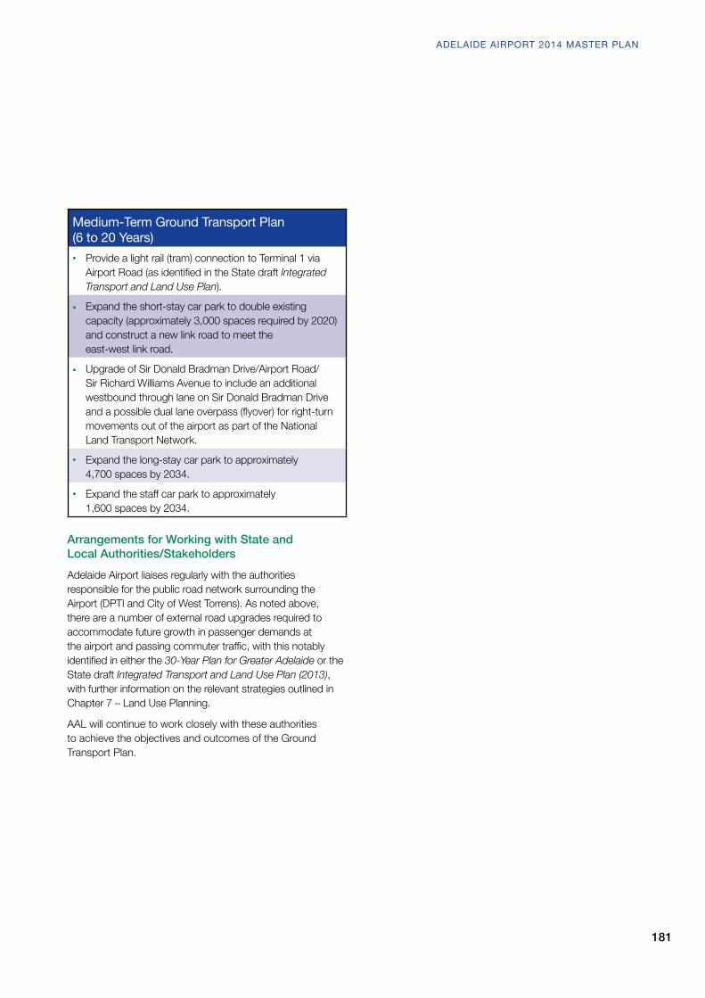
Medium-Term Ground Transport Plan (6 to 20 Years)• Provide a light rail (tram) connection to Terminal 1 via
AirportRoad(asidentifiedintheStatedraft Integrated Transport and Land Use Plan).
• Expand the short-stay car park to double existing capacity (approximately 3,000 spaces required by 2020) and construct a new link road to meet the east-west link road.
• Upgrade of Sir Donald Bradman Drive/Airport Road/Sir Richard Williams Avenue to include an additional westbound through lane on Sir Donald Bradman Drive andapossibleduallaneoverpass(flyover)forright-turnmovements out of the airport as part of the National Land Transport Network.
• Expand the long-stay car park to approximately 4,700 spaces by 2034.
• Expandthestaffcarparktoapproximately 1,600 spaces by 2034.
Arrangements for Working with State and Local Authorities/StakeholdersAdelaide Airport liaises regularly with the authorities responsible for the public road network surrounding the Airport (DPTI and City of West Torrens). As noted above, there are a number of external road upgrades required to accommodate future growth in passenger demands at theairportandpassingcommutertraffic,withthisnotablyidentifiedineitherthe 30-Year Plan for Greater Adelaide or the State draft Integrated Transport and Land Use Plan (2013), with further information on the relevant strategies outlined in Chapter 7 – Land Use Planning.
AAL will continue to work closely with these authorities to achieve the objectives and outcomes of the Ground Transport Plan.
181
ADELAIDE AIRPORT 2014 MASTER PLAN