Embed Size (px)
Citation preview

Dominica
Jan M. Lindsay1, Alan L. Smith2M. John Roobol3 and Mark V. Stasiuk41Seismic Research Unit, The University of the West Indies, Trinidad and Tobago2Department of Geological Sciences, California State University, CA, USA.3Saudi Geological Survey, P.O. Box 54141, Jeddah 21514, Saudi Arabia4Geological Survey of Canada, Pacifi c Division, Vancouver, Canada.

2 VOLCANIC HAZARD ATLAS OF THE LESSER ANTILLES
IntroductionThe information in this contribution is largely based on a recent Volcanic Hazard Assessment prepared for the Government of Dominica by the Seismic Research Unit (2000), together with an extensive re-evaluation of the geology of the island by the authors during the preparation of the accompanying geologic map. Assessment of volcanic hazard was based on a thorough review of past volcanic activity, as evidenced by the distribution and type of existing deposits, comparison with other volcanoes in the Lesser Antilles (e.g. Soufrière Hills, Mt. Pelée) and an evaluation of historical volcanic eruptions, seismicity and geothermal activity.
Geographical settingDominica is located in the central Lesser Antilles and occupies a land area of 750 km2. It is the most rugged island of the Lesser Antilles, being devoid of any flat land greater than 1 km2. It contains two of the highest mountains in the arc: Morne Diablotins (1,421 m) and Morne Trois Pitons (1,394 m). Dominica has 9 major peaks over 1,000 m, each with its own radial drainage systems, and the island has one of the largest river densities on Earth. Dominica has a population of 69,625 (Statistics Division, January 2005), about 23,000 of which live in and around the capital, Roseau, which is located on the southwestern coast of the island.
Previous workThe earliest description of the Geology of Dominica was made by Atwood (1791), and the Boiling Lake was first described in detail by Prestoe (1876). The 1880 phreatic eruption in the Valley of Desolation was described by Bert (1880);; Daubrée (1880a,b);; Eldridge (1880);; Endlich (1880);; Nicholls (1880a,b)
AbstractIn contrast to most other islands in the Lesser Antilles arc which have one major potentially active volcanic centre, Dominica has nine, making it extremely susceptible to volcanic hazards. In fact, Dominica has one of the highest concentrations of potentially active volcanoes in the world. The most recent magmatic eruption in Dominica occurred from Morne Patates, a dome within the Plat Pays volcanic complex, as recently as ~500 years ago, and two phreatic eruptions from the Valley of Desolation have occurred since then, in 1880 and 1997. Frequent swarms of volcanic earthquakes and geothermal activity in both south and north Dominica indicate that the island is still underlain by an active magma reservoir system and that future eruptions are highly likely, possibly within the next 100 years.
Several scenarios for future activity covering the six most seismically and geothermally active volcanic centres are presented here in order of decreasing probability of occurrence during the next century. The most likely activity is a phreatic eruption from the explosion craters of the Valley of Desolation. Such an eruption would be relatively small and would only affect the area directly surrounding the vent. The most likely scenario for a magmatic eruption is a dome-forming eruption from within the Plat Pays volcanic complex. Such an eruption will probably generate dome-collapse pyroclastic flows, pyroclastic surges and lapilli and ash falls. Lahars may also be generated at times of heavy rainfall during and after the eruption. A dome-forming eruption may continue for many years and would affect large areas of southern Dominica. Large volumes of dacitic ash and pumice were erupted in Dominica about 30,000 years ago as part of the largest explosive eruption in the Lesser Antilles arc during the past 200,000 years, and a similar Plinian eruption from the Wotten Waven caldera represents one of the least likely yet most devastating scenarios considered here. Pyroclastic surges resulting from the collapse of a Plinian column would effect most of the island except for the far north. Other possible scenarios for Dominica include explosive magmatic eruptions from Morne Anglais or Morne Plat Pays and dome-forming eruptions from Micotrin or Morne aux Diables. Hazard maps indicating areas most likely to be affected have been generated for the six most-likely scenarios involving major magmatic eruptions in Dominica. These hazard maps have been combined to develop a map of integrated hazard zones for Dominica, indicating overall long-term hazard on the island.
Relief map of Dominica

Dominica-3VOLCANIC HAZARD ATLAS OF THE LESSER ANTILLES
and Watt (1880). Subsequent reconnaissance studies of the general geology and/or geothermal features of the island were made by Sapper (1903), Hovey (1904), Earle (1928), Robson and Willmore (1955), Martin-Kaye (1960;; 1969) and Robson and Tomblin (1966), but little detail was given in these early studies on the volcanic history of the island. Modern volcanological studies on Dominica were initiated by Sigurdsson (1972), who described the Roseau Tuff, one of the large pumice fl ow deposits on the island. Subsequent research on this and the Grand Savanne ignimbrite was published by Carey and Sigurdsson (1980), Sparks et al. (1980a;; 1980b) and Whitham (1985;; 1989). A study of the area around Wotten Waven was carried out by Demange et al. (1985), who produced a detailed geological map of the area and identifi ed the Wotten Waven caldera. The fi rst detailed volcanological and petrological study of the centres in the south of Dominica was carried out by Wills (1974). The southwestern-most corner of the island, often referred to as the Soufrière depression, was described by Wills (1974), Roobol et al. (1983), Wadge (1985) and most recently by Lindsay et al. (2003). Extensive debris avalanche deposits recently discovered off the southwest coast of Dominica are described in Deplus et al. (2001) and Le Friant et al. (2002). Very few studies have been carried out on the geochemistry and petrology of specifi c Dominican volcanic centres, one of these is by Monjaret (1985) who studied the petrology of the older rocks on Dominica. Dominican rocks have, however, been included in several general petrological studies of the Lesser Antilles (e.g. Pushkar 1968;; Donnelly et al. 1971;; Brown et al. 1977;; Arculus and Wills 1980;; Hawkesworth and Powell 1980;; Smith et al. 1980;; Davidson 1984 and Smith and Roobol 1990). Briden et al. (1979), Monjaret (1985) and Bellon (1988) present several age dates for the older volcanic rocks on Dominica, some of which are summarised by Baker et al. (1990);; further age dates are scattered throughout the other references cited here. A preliminary assessment of volcanic hazard in Dominica was made by Wadge (1989). The recent (1998 - present) seismic swarm together with an updated assessment of volcanic hazard has been discussed in a variety of reports and conference papers prepared by the Seismic Research Unit ( Seismic Research Unit 2000 and 2001;; Shepherd et al. 2000;; Stasiuk et al. 2002;; Shepherd et al. 2003).
GeologyWith the exception of a minor discontinuous formation of uplifted Pleistocene to Holocene conglomerates and corals along the west coast, Dominica is essentially made up of volcanic rocks and their weathering products. Based on 43 K-Ar and 50 radiocarbon dates, the volcanic stratigraphy of the island can be subdivided into four units: 1) Miocene, 2) Pliocene, 3) ‘Older Pleistocene’ and 4) ‘Younger Pleistocene’ - Recent. The four units are separated by three unconformities which are not all island-wide, as volcanism continued at some centres while weathering and erosion took place at others which had become extinct.
The west coast of Dominica, along the entire outcrop length of the Pliocene volcanoes (discussed below), is remarkably linear. Along much of this coastline are Pleistocene outcrops of water-worked block and ash fl ow deposits now present as pebble and conglomerate beds which locally contain raised coral reef limestone (Martin-Kaye 1960;; Sigurdsson and Carey 1991).
This strongly suggests that this linear coastline marks a normal fault where the island is being uplifted.
Miocene volcanic rocksThe oldest rocks lie along the east or Atlantic coast and are deeply dissected and weathered low-K basaltic terranes yielding radiometric ages between 6.92 and 5.22 Ma (Monjaret 1985;; Bellon 1988). These older rocks are cut by numerous younger andesitic dikes yielding Pliocene ages (3.35 to 2.76 Ma) (Bellon 1988). With the exception of a suspect 13 Ma date given by Monjaret (1985), there are as yet no dated rocks older than 7 Ma on Dominica that would correspond to the extinct Limestone Caribbee Arc present on Martinique immediately to the south (Andreieff et al. 1976;; Bellon et al. 1974;; Westercamp 1976;; Westercamp and Andreieff 1989).
The remarkable linear sea cliff that forms the northern coast of Dominica. View looking east from near Cape Melville

4 VOLCANIC HAZARD ATLAS OF THE LESSER ANTILLES
K-Ar Age determinations for Miocene, Pliocene and ‘Older Pleistocene’ rocks of Dominica
Description Location Age±error RefMIOCENE ROCKSBasalt lava flow Near Rosalie, east coast 5.22±0.26 Ma 1Basalt lava flow Middle Pagua River, east coast 6.19±0.93 Ma 2Basalt lava flow Good Hope, east coast 6.70±0.50 Ma 2Basalt lava flow Good Hope, east coast 6.79±1.02 Ma 2Basalt lava flow Middle Pagua River, east coast 6.92±0.52 Ma 1Basalt sill N.E. of Belles 12.94±1.94 Ma* 1PLIOCENE ROCKSDike Castle Bruce River 2.76±0.21 Ma 2Dike St. Sauveur 3.06±0.23 Ma 2Dike Near Bells 3.35±0.17 Ma 2Cochrane-Mahaut? North bank of Boeri River 1.77±0.70 Ma 3Andesite lava flow Chapara Estate, Cochrane 1.92 Ma 4Dacite lava flow Cochrane 2.39±0.12 Ma 2Andesite lava flow Morne Cabrits Marons 2.51±0.13 Ma 2Andesite lava flow Near Warner 2.53±0.13 Ma 2Andesite lava flow River Claire 2.82 Ma 4Subaqueous andesite lava flow Check Hall Estate 2.83±0.14 Ma 2Pillow lava Massacre 2.85±0.14 Ma 2? Cochrane 3.00±0.15 Ma 2Conglomerate Ravine Bernard, Bernard Estate 3.14±0.16 Ma 2Subaqueous basalt Left bank Boeri River, S. of Cochrane 3.14±0.16 Ma 2Andesite lava flow Roseau River, Fond Cani 3.15±0.16 Ma 2ConcordBasalt lava flow Lower Pagua River, Concord 2.50±0.38 Ma 2Basalt lava flow Lower Pagua River, Concord 2.58±0.38 Ma 2Subaqueous basalt Lower Pagua River, Concord 2.66±0.40 Ma 2Older Morne DiablotinsAndesite lava flow Near Morne Raquet 2.21±0.11 Ma 1Dacite dome Morne Espaniol 2.24±0.34 Ma 2Subaqueous basalt (Diablotins?) Marigot Bay 2.70±0.20 Ma 2Basalt lava flow Near Hansen 3.41±0.17 Ma 2Andesite lava flow Near Colihaut 3.72±0.28 Ma 2FoundlandAndesite lava flow Upper Savanne River 1.12±0.07 Ma 3Basalt lava flow Near Stowe 2.23±0.33 Ma 2Basalt lava flow Near Fond St. Jean 2.27±0.17 Ma 2OLDER PLEISTOCENE ROCKSMorne DiablotinsAndesite lava flow Bioche 1.77±0.13 Ma 2Morne Aux DiablesDacite dome West Cabrit 1.68±0.25 Ma 2Block and ash flow deposit Hermitage Bay 1.72±0.13 Ma 2Andesite lava flow ? 2.01±0.30 Ma 1Ma=million years. *Age regarded as too old due to hydrothermal alteration of sample.References for age tables as follows: 1 = Monjaret (1985);; 2 = Bellon (1988);; 3 = Briden et al. (1979);; 4 = Demange et al. (1985);; 5 = Sparks et al. (1980a);; 6 = Wadge (1989);; 7 = Smith and Roobol, unpublished data;; 8 = Wadge (1985);; 9 = Le Friant et al. (2002);; 10 = Lindsay et al. (2003);; 11 = Seismic Research Unit (2000);; 12 = Sigurdsson and Devine, unpublished data;; 13 = Roobol et al. (1983);; 14 = Sigurdsson and Carey (1991);; 15 = Carey and Sigurdsson (1980);; 16 = Sigurdsson (1972).
Pliocene volcanic centresA major unconformity above the Miocene rocks is suggested by a distinct gap in the radiometric ages between 5.2 and 3.7 Ma. Field evidence for this unconformity is, however, lacking, as the appropriate outcrops are located in the inaccessible, densely forested eastern side of the island. In contrast, from about 3.7 Ma volcanism appears to have been almost continuous, forming a number of now largely extinct centres that are so deeply
dissected that only outlines of their characteristic morphology can be seen. The most widespread deposits of these Pliocene volcanoes appear to comprise remnants of large basaltic to andesitic stratovolcanoes. In the northern half of the island (north of latitude 15o 25’ N) a cream-coloured saprolite surface (up to 7 m thick) overlain by 3 m of laterite is widely developed on the Pliocene deposits. It is estimated that the age of this surface, which indicates a hiatus, is around 2 Ma. This surface does not

Dominica-5VOLCANIC HAZARD ATLAS OF THE LESSER ANTILLES
appear to be present on top of Pliocene deposits of the Foundland centre in the south, suggesting that this centre remained active through the Pliocene and into the Pleistocene;; an idea supported by a date of 1.12 Ma for its younger deposits.
Cochrane-Mahaut centreThe geology of the south central part of Dominica is dominated by the eroded remains of a large stratovolcano termed the Cochrane-Mahaut centre (Bellon 1988). This centre is composed of basaltic pillow lavas and submarine volcanic breccias in its older sections and thick subaerial andesitic lava flows interbedded with pyroclastic deposits in its younger sections. The youngest age of the submarine deposits appears to be around 2.83 Ma (Demange et al. 1985;; Monjaret 1985;; Bellon 1988) suggesting that after this time the volcano was above sea level. Morne Cabrits Marons, Morne Cola Anglais, Deux Saisons, Morne Boyer, Morne Couronne and Morne Negres Marrons all represent remnants of this stratovolcano.
Remnants of the Pliocene Cochrane-Mahaut centre: Mornes Deux Saisons, Boyer and Cola Anglais (L to R) from the northwest
Raised submarine volcaniclastic layers in Pleistocene conglomerates and limestones, west coast of Dominica
Grand Bois and Concord centresIn the central and northern parts of the island, highly dissected remnants of other Pliocene volcanoes were recognised, mainly on the basis of morphology, by Martin-Kaye (1960), who named two of the centres Grand Bois and Concord. The identification of these highly dissected terranes as Pliocene was later confirmed by K-Ar dating (Monjaret 1985;; Bellon 1988). These centres range from basaltic to dacitic in composition, with much of the former occurring as subaqueous deposits. The more siliceous deposits occur as subaerial pyroclastic deposits, lava flows and domes (e.g. Morne Espaniol, a well preserved Pelean dome on the northwest coast that is probably related to Pliocene activity at Morne Diablotins).
Foundland centreThe Pliocene Foundland centre in the south of the island is separated from the remnants of the Cochrane-Mahaut stratovolcano by a belt of Pleistocene to Recent volcanoes (discussed below). Foundland is a stratovolcano of dominantly basaltic composition. The oldest rocks are exposed at the base of the Wai Wai and Daroux sea cliffs, where they form sequences of volcanic breccias interpreted as the deposits of subaerial lava flows that entered the sea (Wills 1974). Further inland, subaerial flows up to 30 m thick of basalt with some andesite are interbedded with scoriacous pyroclastic deposits (Wills 1974;; Sigurdsson and Carey 1991;; Smith unpub. data).
There is no seismicity or geothermal activity associated with any of the Pliocene centres, and they are considered unlikely to erupt again.
‘Older Pleistocene’ volcanic centresThe saprolite-laterite disconformity discussed above is overlain by the third stratigraphic unit, which is of ‘Older Pleistocene’ age. Centres belonging to this unit are all confined to the northern half of the island and are characterised by the presence of Pelean domes and associated aprons of block and ash flow deposits.
Morne aux Diables, Diablotins and associated centresA number of independent ‘Older-Pleistocene’ volcanic centres are present north of the Layou River, including Morne aux Diables (forming a peninsula at the north end of the island) and the largest volcano on the island, Morne Diablotins. The ‘Older Pleistocene’ portion of Morne Diablotins was built over an extensive base of Pliocene volcanic rocks, and, like Morne aux Diables, is composed of andesitic lava flows, domes, and block and ash flow deposits. Both of these volcanoes are also associated with young unconsolidated pyroclastic deposits, suggesting that the volcanism at these centres continued into the Holocene. This, together with occasional shallow seismicity in the area, indicates that there is a possibility they may erupt again in the future. These volcanoes are described in more detail below under the section on potentially active volcanoes.
Three smaller peaks on the southern flanks of Morne Diablotins (Mosquito Mountain, Morne McFarlin and Morne Pierre Louis) are interpreted as single Pelean domes surrounded by their pyroclastic aprons. These centres are thought to be of ‘Older Pleistocene’ age and are regarded as being extinct.
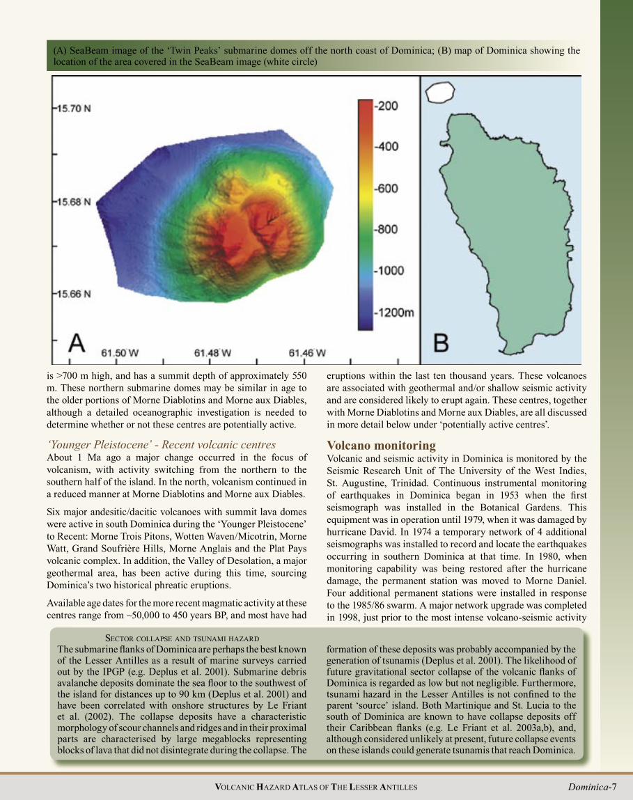
Submarine domesIn March 2002, a SeaBeam bathymetric survey was conducted from the NOAA ship Ronald H. Brown directly off the coast of Dominica. This survey confirmed the presence of two large submarine domes, approximately 5 km off the northern coast, that were visible on the bathymetry map but not described in the study of Deplus et al. (2001). These domes are here informally referred to as “Twin Peaks”. The summit of the highest dome (15.671o N;; 61.476o W) was 153 m below sea level, and both domes rise >1,000 m from the ocean floor. Another smaller submarine dome was observed approximately 6 km west of Lamothe Bay on the NW coast (summit = 15.62o N;; 61.53o W). This dome

6 VOLCANIC HAZARD ATLAS OF THE LESSER ANTILLES
Geological map of Dominica (see map pocket for a larger-scale version of this map)
Dominica-7VOLCANIC HAZARD ATLAS OF THE LESSER ANTILLES
is >700 m high, and has a summit depth of approximately 550 m. These northern submarine domes may be similar in age to the older portions of Morne Diablotins and Morne aux Diables, although a detailed oceanographic investigation is needed to determine whether or not these centres are potentially active.
‘Younger Pleistocene’ - Recent volcanic centresAbout 1 Ma ago a major change occurred in the focus of volcanism, with activity switching from the northern to the southern half of the island. In the north, volcanism continued in a reduced manner at Morne Diablotins and Morne aux Diables.
Six major andesitic/ dacitic volcanoes with summit lava domes were active in south Dominica during the ‘Younger Pleistocene’ to Recent: Morne Trois Pitons, Wotten Waven/ Micotrin, Morne Watt, Grand Soufrière Hills, Morne Anglais and the Plat Pays volcanic complex. In addition, the Valley of Desolation, a major geothermal area, has been active during this time, sourcing Dominica’s two historical phreatic eruptions.
Available age dates for the more recent magmatic activity at these centres range from ~50,000 to 450 years BP, and most have had
(A) SeaBeam image of the ‘ Twin Peaks’ submarine domes off the north coast of Dominica;; (B) map of Dominica showing the location of the area covered in the SeaBeam image (white circle)
SECTOR COLLAPSE AND TSUNAMI HAZARD
eruptions within the last ten thousand years. These volcanoes are associated with geothermal and/or shallow seismic activity and are considered likely to erupt again. These centres, together with Morne Diablotins and Morne aux Diables, are all discussed in more detail below under ‘potentially active centres’.
Volcano monitoringVolcanic and seismic activity in Dominica is monitored by the Seismic Research Unit of The University of the West Indies, St. Augustine, Trinidad. Continuous instrumental monitoring of earthquakes in Dominica began in 1953 when the fi rst seismograph was installed in the Botanical Gardens. This equipment was in operation until 1979, when it was damaged by hurricane David. In 1974 a temporary network of 4 additional seismographs was installed to record and locate the earthquakes occurring in southern Dominica at that time. In 1980, when monitoring capability was being restored after the hurricane damage, the permanent station was moved to Morne Daniel. Four additional permanent stations were installed in response to the 1985/86 swarm. A major network upgrade was completed in 1998, just prior to the most intense volcano-seismic activity

8 VOLCANIC HAZARD ATLAS OF THE LESSER ANTILLES
Age determinations for ‘Younger Pleistocene’ - Recent rocks of Dominica
Description Location Age ± error Method Ref.Valley of Desolation explosion cratersWood Phreatic explosion crater 2,900 ± 370 14C 4Wood Phreatic explosion crater 3,750 ± 100 14C 4Wood in lahar deposit River Blanc near Casso 4,050 ± 80 14C 4Plat Pays Volcanic ComplexBlock and ash flow deposit, Patates Northeast foot of Patates dome 450 ± 90 14C 13Block and ash flow deposit, Patates Near Soufrière school 685 ± 55 14C 10? Near fumaroles, Sulphur Springs 1,100 ± 100 14C 4Ignimbrite, Patates Turn off to Sulphur Springs 1,560 ± 40 14C 10Pumice rich surge deposit, Patates? Scotts Head 2,380 ± 75 14C 9Andesitic pyroclastic flow deposit, Morne Plat Pays
Grand Bay quarry (near Geneva Estate)Grand Bay quarry (near Geneva Estate)Grand Bay quarry (near Geneva Estate)
6,600 ± 506,670 ± 606,825 ± 75
14C9710
Block and ash flow deposit, Morne Plat Pays Mt. Lofty Rd, near Refuge Estate 6,650 ± 50 14C 10Airfall pumice deposit, Cabrits dome Pte. Guignard Estate Rd 35,800 ± 260 14C 10Andesite dike Scotts Head 0.24 ± 0.07 Ma K-Ar 2Andesite lava flow, La Vue/Vigie dome Sibouli 1.10 ± 0.08 Ma K-Ar 1Block and ash flow deposit, La Falaise dome La Falaise quarry >47,330# 14C 10Morne AnglaisScoria fall? Near Soufrière 26,400 ± 2,500 14C 4Scoria fall? Soufrière Rd, N side of depression 28,450 ± 1,500 14C 8Block and ash flow deposit Giraudel 0.43 Ma* K-Ar 4Wotten Waven/Micotrin complex and large ignimbritesMicotrin?Pumiceous pyroclastic flow deposit Near tram line 1,020 ± 40 14C 11Pumiceous pyroclastic flow deposit Valley of Desolation trail 1,025 ± 45 14C 11Pumiceous pyroclastic flow deposit Start of Valley of Desolation trail 1,050 ± 70 14C 4Block and ash flow deposit Laudat 1,160 ± 45 14C 11Block and ash flow deposit Bath Estate 25,370 ± 120 14C 11Pumiceous pyroclastic flow deposit Micotrin ring road 26,380 ± 190 14C 11Block and ash flow deposit Laudat 26,500 ± 900 14C 6Roseau TuffPumiceous surge deposit Confluence Douce and Roseau rivers 26,400 ± 1500 14C 4Pumiceous surge deposit Du Mas Estate 27,600 ± 1,130 14C 4Ignimbrite Goodwill quarry 28,400 ± 900 14C 16Airfall pumice Goodwill quarry 29,000 ± 4,000 14C 15Ignimbrite Goodwill >33,200 14C 15Ignimbrite Goodwill quarry >34,000 14C 16Airfall pumice Goodwill 35,000 ± 2,200 14C 6Ignimbrite Goodwill quarry 46,000 ± 4500 14C 16Grand Fond – Rosalie unitsPumiceous pyroclastic flow deposit En Bas Petit Fond (Ma Robert) 19,500 ± 500 14C 12Ignimbrite Grand Fond 27,600 ± 600 14C 15Ignimbrite Tete Grand Fond 31,000 ± 4,000 14C 15Ignimbrite Rosalie (Ma Robert) 34,600 ± 1,500 14C 12Wall House Quarry unitsIgnimbrite (distal) Wall House quarry, Loubiere 30,270 ± 200 14C 7Pumiceous pyroclastic flow deposit Wall House quarry, Loubiere 38,610 ± 350 14C 10Grand Bay ignimbriteDistal facies Near Stowe >27,200 14C 14Distal facies Fond St. Jean >36,800 14C 14Distal facies Fond St. Jean 38,890 ± 600 14C 7Morne WattWood from reworked block and ash flow deposit River Padu near Hartington estate 1,270 ± 75 14C 4Wood in lahar River Blanc near Wotten Waven 1,350 ± 75 14C 4Pumiceous pyroclastic flow deposit Perdu Temps trail;; divide to River Jack 10,290 ± 60 14C 11Andesite lava flow Upper part of Trois Pitons River 0.46 Ma K-Ar 4

Dominica-9VOLCANIC HAZARD ATLAS OF THE LESSER ANTILLES
Description Location Age ± error Method Ref.Morne Trois PitonsBlock and ash flow deposit Belles bridge 17,240 ± 720 14C 6Block and ash flow deposit Belles/Point Casse 25,310 ± 230 14C 13Pumiceous pyroclastic flow deposit Layou >40,000 14C 6Grand Soufrière HillsBlock and ash flow deposit Near mouth of Pt. Mulatre River 10,320 ± 40 14C 7Lateral blast deposit Corossol 11,000 ± 85 14C 11Block and ash flow deposit Eastern foot of dome 0.8 ± 0.4 Ma* K-Ar 6Morne DiablotinsGrand Savanne Ignimbrite Grand Savanne >22,200 14C 5Surge deposit Gabriel >40,000 14C 6Block and ash flow deposit Point Ronde pyroclastic flow fan >46,620 14C 7Andesite lava Summit dome 0.7 ± 0.5 Ma* K-Ar 6Block and ash flow deposit Pointe la Soie 0.72 ± 0.11 Ma K-Ar 1Morne aux DiablesBlock and ash flow deposit Near Enbas on east coast >46,740 14C 7
Volcano monitoring network on Dominica
in Dominica since instrumental monitoring began. Two further stations were added in 2000 and 2003, and the network now (2005) comprises 11 permanent stations. Ten of these stations transmit their data to two complete seismograph network base stations at Morne Daniel and Wesley. The Guadeloupe Volcano Observatory (IPGP) operates one seismograph in the northwest of the island;; data from this instrument are included in the Dominica network.
Between October 1998 and December 2004 a 22-station GPS network was established in southern Dominica, and in early 2004 a network of 8 stations was installed around Morne aux Diables in the north. These networks are reoccupied at regular
Taking GPS measurements, Galion
Age is given in ‘years before present’ unless otherwise stated. Ma = million years. *Thought by original workers to be too old. # age is from coral, which may be altered or entrained, resulting in a false age for the deposit.For references see the age table for Miocene, Pliocene and ‘Older Pleistocene’ rocks.
intervals to monitor for ground deformation. Gases and fluids from geothermal areas in Dominica are collected and analysed at roughly half yearly intervals to look for thermal or compositional variations which may reveal changes in the behaviour of the volcano.
10 VOLCANIC HAZARD ATLAS OF THE LESSER ANTILLES
SEISMICITY IN DOMINICA
Historical volcanic earthquake swarms in Dominica
Date Location Probable centre Comments RefFeb. to Jun. 1765 S. Dominica Southern centres 150 felt shocks 1, 10Oct. 1841 N. Dominica Diablotins/Aux Diables Up to 20 felt earthquakes per day 1Jan. to Apr. 1849 S. Dominica Plat Pays volcanic complex? 24 felt earthquakes in one night in Soufrière area 1Feb. to Mar. 1893 N. Dominica Diablotins/Aux Diables Frequent shocks felt in mid Mar. 1;; 7Oct. 1937 to Apr. 1938 S. Dominica Southern centre(s) 13 shocks felt within a few hours on 1 Apr. 1Sep. 1959 to May 1960 S. Dominica Southern centre(s) Not felt. Exact locations unknown, but within 5 km of
Roseau 2;; 3Jun. 1967 S. Dominica Southern centre(s) Lasted 2 days, Jun. 19-20;; 65 events 8Jan. to Jun. 1969 ? ? 126 events between Jan. 1–5;; swarm until Jun. 8Jan. 1971 ? ? 25 shocks felt on Jan. 15 8
Apr. to Nov. 1974 S. Dominica Plat Pays volcanic complexMajor belt of epicentres trending E-W through Boiling Lake and Wotten Waven. >190 earthquakes recorded on Apr. 19
4;; 9
Feb. to Jun. 1976 S. Dominica Southern centre(s) Epicentres in Roseau, extending offshore to SW 8Nov. 1985 to Jun. 1986 S. Dominica Plat Pays volcanic complex Epicentres beneath Morne Plat Pays 5Dec. 1994 to Jan. 1995 S. Dominica Plat Pays volcanic complex Epicentres beneath Morne Plat Pays 8Nov. to Dec. 1997 S. Dominica Plat Pays volcanic complex Epicentres beneath Morne Plat Pays 8Oct. 1998 to Jul. 2000 S. Dominica Plat Pays volcanic complex &
Anglais >180 earthquakes recorded on Oct. 23, 1998 6
Jan. 20-25, 2000 N. Dominica Single station – no locations possible 66 earthquakes recorded on Jan. 20, 2000 8
Feb. to Jun. 2003 N. Dominica Aux Diables/Diablotins >50 earthquakes recorded between Feb. 15 – 26;; >500 earthquakes recorded between Apr. 14 – 26 8
References: 1: Robson (1964);; 2: Robson and Barr (1967);; 3: Robson and Barr (1960);; 4: Isaacs and Shepherd (1986);; 5: Shepherd (1986);; 6: Seismic Research Unit (2000);; 7: Elliot (1893);; 8: Seismic Research Unit archives;; 9: Newhall and Dzurisin (1988);; 10: Atwood (1791).
Daily numbers (bars) and cumulative total (line) of local earthquakes in Dominica;; September 1998 – April 2004
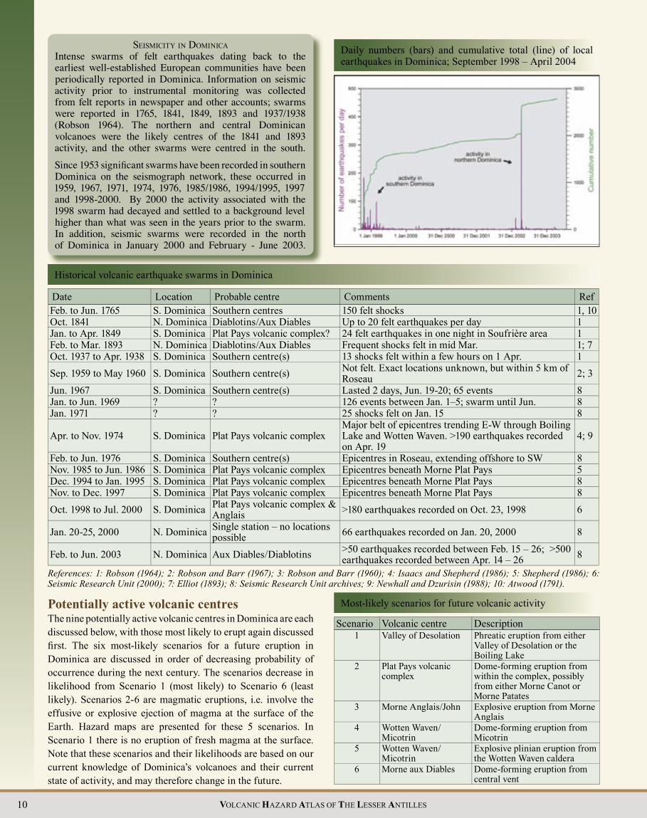
Potentially active volcanic centresThe nine potentially active volcanic centres in Dominica are each discussed below, with those most likely to erupt again discussed fi rst. The six most-likely scenarios for a future eruption in Dominica are discussed in order of decreasing probability of occurrence during the next century. The scenarios decrease in likelihood from Scenario 1 (most likely) to Scenario 6 (least likely). Scenarios 2-6 are magmatic eruptions, i.e. involve the effusive or explosive ejection of magma at the surface of the Earth. Hazard maps are presented for these 5 scenarios. In Scenario 1 there is no eruption of fresh magma at the surface. Note that these scenarios and their likelihoods are based on our current knowledge of Dominica’s volcanoes and their current state of activity, and may therefore change in the future.
Most-likely scenarios for future volcanic activity
Scenario Volcanic centre Description1 Valley of Desolation Phreatic eruption from either
Valley of Desolation or the Boiling Lake
2 Plat Pays volcanic complex
Dome-forming eruption from within the complex, possibly from either Morne Canot or Morne Patates
3 Morne Anglais/John Explosive eruption from Morne Anglais
4 Wotten Waven/ Micotrin
Dome-forming eruption from Micotrin
5 Wotten Waven/ Micotrin
Explosive plinian eruption from the Wotten Waven caldera
6 Morne aux Diables Dome-forming eruption from central vent

Dominica-11VOLCANIC HAZARD ATLAS OF THE LESSER ANTILLES
Seismicity in Dominica during the periods 1966-97, 1998, 1999 and 2000
2000
19981966-97
1999

12 VOLCANIC HAZARD ATLAS OF THE LESSER ANTILLES
Potentially active volcanic centres on Dominica
Seismicity in Dominica during the periods 2001, 2002 and 2003
20022001
2003

Dominica-13VOLCANIC HAZARD ATLAS OF THE LESSER ANTILLES
Valley of DesolationAlong the length of Dominica are a number of crater-like features, usually in the rain forest and not easily studied, that may be phreatic/phreatomagmatic explosion craters. The best known concentration of these craters is the Valley of Desolation/Boiling Lake area, referred to in the past as the “Grand Soufrière” (e.g. Sapper 1903;; Robson and Wilmore 1955), where several small explosion craters are associated with vigorous hydrothermal activity. Since the name “Grand Soufrière” is no longer commonly used in Dominica, in this chapter we refer to this area (extending from the actual Valley of Desolation to the Boiling Lake) as the “Valley of Desolation”.
Valley of Desolation and the Boiling Lake were “mashed” on their southern sides and untouched on the other (Endlich 1880). He noted that the Boiling Lake was very active but almost empty following the eruption, measuring just 15 by 12 feet. Neither Endlich (1880) nor Nicholls (1880b) found any trace of juvenile material or charred wood in the eruptive products, and they interpreted the event as a non-magmatic steam explosion. This was supported by the petrological observations of Daubrée (1880a,b) and Wadsworth (1880), who described the material produced during the eruption as a mixture of mineral fragments and altered material and indicated that no fresh magmatic material was present.
1997 phreatic eruptionThe 1997 eruption was much smaller than the 1880 eruption. It occurred during the night from the July 8 to 9, apparently from one of the vents on the southeastern side of the Valley of Desolation (the same area as the vent for the 1880 eruption). Rocks, together with a dark grey, fine-grained deposit, were spread over an area estimated to be 50 ft x 50 ft, and the face of the cliff on the eastern side of the valley was lightly covered with the grey substance up to about 30-50 ft above the base of the cliff (C. Shillingford written comm. 1997). Plants in the area were also covered, some up to 53 m from the vent (James 1997a), and some were scorched. Komorowski and Hammouya (1998) report that ash from the 1997 eruption contained fragments of non-altered lava, rounded hydrothermally altered igneous minerals and hydrothermal minerals such as silica and iron oxides. Ash leachate analyses did not indicate any strong magmatic or deep hydrothermal signature. They interpreted the event as a small phreatic eruption, most likely triggered by reactivation of the hot springs area in the preceding months together with the occurrence of several landslides from the unstable walls of the Valley of Desolation.
Geothermal activityThis region, which has in the past been referred to as the “Grande Soufrière”, is the most thermally active area in Dominica. It includes the Valley of Desolation, the Boiling Lake and the areas identified by Robson and Willmore (1955) as the Eastern and Western Hot Springs. This region is characterised by numerous hot springs, bubbling pools, and fumaroles over an area of approximately 0.5 km2. Over the last 100 years, temperatures of fumaroles have generally ranged between 91 and 99 oC and those of hot springs and bubbling mud pools between 40 and 96 oC (Sapper 1903;; Robson and Willmore 1955;; Brown 2002).
Past eruptive activityDemange et al. (1985) provide three dates related to prehistoric phreatic activity of the Valley of Desolation. One of these dates (4,050 years BP) is of a lahar deposit exposed in the River Blanc near Casso, thought to have originated from the Valley of Desolation. The other two (3,750 and 2,900 years BP) are from lithic ash deposits within two small explosion craters in the Valley itself. These dates suggest that explosive activity has occurred from vents within the Valley of Desolation for at least 4,000 years.
Historical eruptions The Valley of Desolation has been the source of two historical phreatic eruptions, on January 4, 1880 and on July 9, 1997. Neither explosion was directly witnessed.
1880 phreatic eruptionVarious aspects of the 1880 eruption have been described by Bert (1880), Daubrée (1880a,b), Eldridge (1880), Endlich (1880), Nicholls (1880a,b) and Watt (1880). The ash from the 1880 eruption fell over an elongated area about 3 km wide downwind of the vent and was thickest (60 cm) closest to the vent (Nicholls 1880b). Six mm of ash and accretionary lapilli fell over Roseau, and slight ash fall was even noticed on a boat 19 km out to sea. The area covered by the ash was estimated at 55 km2 (Nicholls 1880b). Lahars were generated in the Roseau and Pointe Mulatre rivers and the forest surrounding the “Grand Soufrière” was largely destroyed (Nicholls 1880b). Endlich (1880) visited the area two months after the eruption, and estimated the volume of erupted material at 27 million tonnes. He described the vent area as a crater-like depression in the (now) Valley of Desolation area. He ruled out the Boiling Lake as a possible vent area, because the bare broken trunks and stumps of trees between the
The Eastern Hotsprings area (left) and Boiling Lake (right) of the Valley of Desolation
The entrance to the Valley of Desolation

14 VOLCANIC HAZARD ATLAS OF THE LESSER ANTILLES
Main geothermal features in Dominica (Temperature, GPS and pH data from Joseph and Lindsay 2002 and Joseph and Robertson 2003)
Geothermal area and specific location Feature Coordinates Date Temperature pH
Valley of DesolationBoiling Lake Water’s edge, Boiling Lake N 15º19.120' 30.05.03 89.1 ºC 4
W 61º17.684' 17.11.02 85.9 ºC 421.04.01 80 ºC 525.11.00 83 – 84 ºC 4
Upper Eastern Hot Springs Small stream fumarole N 15º19.124' 30.05.03 96.6 ºC 3W 61º17.812’ 17.11.02 97.8 ºC 1
21.04.01 83 ºC 4Vigorously bubbling spring 30.05.03 37.1 ºC 7
25.11.00 95.8 ºC Black water spring 30.05.03 62.3 ºC 8
25.11.00 68.0 ºC 9Lower Eastern Hot Springs Vigorous fumarole N 15º18.963' 17.11.02 97.7 ºC 3
W 61º17.725' 21.04.01 96 ºC 525.11.00 97.1 ºC
Valley of Desolation Bubbling pool 1 N 15º18.864' 8.11.03 57.0 ºC 2W 61º18.075' 30.05.03 84.3 ºC 2
17.11.02 93.5 ºC 221.04.01 74 ºC 125.11.00 95 ºC 2
Bubbling pool 2 N 15º19.820' 8.11.03 30.4 ºC 2W 61º17.086' 30.05.03 86.8 ºC 6
17.11.02 75.3 ºC 621.04.01 90 ºC 325.11.00 80.7 ºC 4
Plat Pays volcanic complexUpper Sulphur Springs Bubbling Sulphur hole N 15º14.675' 19.11.02 97.4 ºC 1.5
W 61º20.842' 19.04.01 96 ºC 526.11.00 97.4 ºC 2
Pat’s bubbling pool N 15º14.675' 19.11.02 91.5 ºC 1W 61º20.842'
Lower Sulphur Springs Museum pool N 15º14.115' 19.11.02 34.3 ºC 3W 61º20.992'
Galion Top fumarole, side of hill N 15º13.190' 6.11.03 98.3 ºC 5W 61º 21.345' 19.11.02 98.1 ºC 3.5
19.04.01 96 ºC 826.11.00 97.9 ºC
Hot ground behind village N 15º13.433' 6.11.03 90.6-95.7 ºC W 61º 21.517' 19.11.02 85.4 – 96.3 ºCChampagne Underwater gas vent N 15º14.39'
W 61º22.43'

Dominica-15VOLCANIC HAZARD ATLAS OF THE LESSER ANTILLES
The Boiling Lake itself has an area of approximately 85 x 75 m, and its usual depth has been estimated at about 10-15 m. Over the last 100 years, temperatures taken at the edge of the Boiling Lake have generally ranged between 80 and 90o C (Sapper 1903;; Robson and Willmore 1955;; Brown 2002). However, the water level and temperature of the lake have both been known to drop considerably in the past, for example in 1876, 1887, 1900, 1901, 1971, 1988 (Ober 1880;; James 1988) and most recently in December 2004 – present. A small explosion in 1901 from an “empty” lake released harmful gases (probably mainly CO2) into the atmosphere and killed two people who were at the water’s edge at the time (Elliot 1938;; Bell 1946). In 1971, locals reportedly bathed in the Boiling Lake, whose levels and temperatures had dropped. In 1988 the normal water level had dropped by about 30 ft, and the temperature at the waters edge was <30o C (James 1988). The most recent changes began towards the end of December 2004, when the lake stopped bubbling, cooled down, and almost emptied, with water levels dropping to 30-40 ft below the high-water mark. Throughout January the water level
Sketch map of the Valley of Desolation
1Robertson and Mohais (2004);; 2Smith and Roobol (unpublished data).
Geothermal area and specific location Feature Coordinates Date Temperature pH
Wotten Waven/MicotrinWotten Waven Yellow pool N 15º19.184' 5.11.03 64.3 ºC 5
W 61º20.336' 29.05.03 88.2 ºC 320.11.02 74.0 ºC 2.519.04.01 87 ºC 226.11.00 70.6 ºC 3
Small spouter N 15º19.184' 20.11.02 87.2 ºCW 61º20.336' 19.04.01 94 ºC 3
26.11.00 94.7 ºC 4Jan’s bubbling pool N 15º19.184' 5.11.03 43.0 ºC 4
W 61º20.336' 29.05.03 91.2 ºC 320.11.02 49.5 ºC 3.5
Bamboo Shower N 15º19.11' 20.11.02 37.4 ºC 6W 61º20.43'
Morne aux DiablesPenville cold soufrière Nancy’s pool N 15º37.161' 6.11.03 25.7 ºC 1
W 61º26.393' 18.11.02 23.7 ºC 120.04.01 32 ºC 1
Eric’s pool N 15º37.161' 6.11.03 25.4 ºC 3W 61º26.393' 29.05.03 24.9 ºC 2
18.11.02 24.2 ºC 2.520.04.01 <25 ºC 1
Bubbling spring in stream N 15º37.110' 29.05.03 28.6 ºC 3W 61º26.234' 18.11.02 28.1 ºC 5
Glanvillia hot springs Area 2.5 x 1.5 km in size, N 15º33.5' 05.05.041 88 ºC -onshore and offshore vents W 61º28.2' 2003/20042 Up to 102 ºC 2.5

16 VOLCANIC HAZARD ATLAS OF THE LESSER ANTILLES
areas a considerable distance downwind of the vent. The ash cloud generated during the 1880 phreatic eruption from the Valley of Desolation was carried westward by the wind, and ash fell over an elongated area downwind of the source about 3 km wide. The sky darkened over Roseau, and up to 6 mm of ash and accretionary lapilli fell over the town. In general, however, such an eruption will only be dangerous to humans if they are near the vent at the time;; and major effects are likely to be constrained within a two km radius of the vent. However, the water, ash and steam ejected during a phreatic eruption are likely to be acidic, and would contaminate nearby streams. Phreatic eruptions may also eject enough water to generate small fl oods or lahars in nearby streams, and lahars were generated in the Roseau and Pointe Mulatre rivers in this way during the 1880 phreatic eruption. Despite these possible effects, the area affected by a phreatic eruption will be very small compared with that affected by a magmatic eruption.
gradually rose again, although temperatures remained low. On January 28, the surface of the lake was 9-10 ft below high-water mark, and a temperature of 15 oC was measured at the water’s edge (A. James, pers. comm. Feb. 2005).
Scientist sampling gas at a bubbling pool, Valley of Desolation
EXPLOSION CRATERS
Future eruptions Phreatic eruption from a Valley of Desolation explosion crater ( Dominica scenario 1) The most likely type of volcanic activity to occur from the Valley of Desolation is a phreatic eruption from the Boiling Lake or one of the other explosion craters in the area. Phreatic eruptions are steam-driven eruptions that eject fragments of old rock and ash into the air and are very common in geothermal areas. Phreatic eruptions do not erupt fresh magma, although they can emit dangerous gases. Individual phreatic explosions may last up to an hour or more, and a series of blasts may continue intermittently for several months or even years. They may be accompanied by volcanic earthquakes. In some instances, particularly if they occur in a sequence, phreatic eruptions may represent precursory activity to an actual magmatic eruption.
In the event of a phreatic eruption from the Valley of Desolation, the direct effects will probably only be felt over a small area of up to a few 100s of metres from the vent, although ballistic projectiles may be thrown up to 1-2 km and ash fall may affect
The Boiling Lake, almost empty, December 28, 2004
The Boiling Lake, May 30, 2003, showing a more common water level (the water level here covers the prominent terrace seen in the photograph below)
Dominica-17VOLCANIC HAZARD ATLAS OF THE LESSER ANTILLES
Geological sketch map of the Plat Pays volcanic complex (adapted from Lindsay et al. 2003)
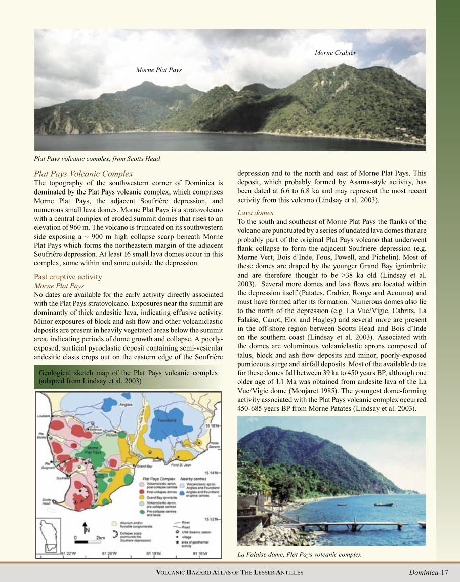
Plat Pays Volcanic ComplexThe topography of the southwestern corner of Dominica is dominated by the Plat Pays volcanic complex, which comprises Morne Plat Pays, the adjacent Soufrière depression, and numerous small lava domes. Morne Plat Pays is a stratovolcano with a central complex of eroded summit domes that rises to an elevation of 960 m. The volcano is truncated on its southwestern side exposing a ~ 900 m high collapse scarp beneath Morne Plat Pays which forms the northeastern margin of the adjacent Soufrière depression. At least 16 small lava domes occur in this complex, some within and some outside the depression.
Past eruptive activity Morne Plat PaysNo dates are available for the early activity directly associated with the Plat Pays stratovolcano. Exposures near the summit are dominantly of thick andesitic lava, indicating effusive activity. Minor exposures of block and ash flow and other volcaniclastic deposits are present in heavily vegetated areas below the summit area, indicating periods of dome growth and collapse. A poorly-exposed, surficial pyroclastic deposit containing semi-vesicular andesitic clasts crops out on the eastern edge of the Soufrière
Plat Pays volcanic complex, from Scotts Head
Morne Plat Pays
Morne Crabier
depression and to the north and east of Morne Plat Pays. This deposit, which probably formed by Asama-style activity, has been dated at 6.6 to 6.8 ka and may represent the most recent activity from this volcano (Lindsay et al. 2003).
Lava domesTo the south and southeast of Morne Plat Pays the flanks of the volcano are punctuated by a series of undated lava domes that are probably part of the original Plat Pays volcano that underwent flank collapse to form the adjacent Soufrière depression (e.g. Morne Vert, Bois d’Inde, Fous, Powell, and Pichelin). Most of these domes are draped by the younger Grand Bay ignimbrite and are therefore thought to be >38 ka old (Lindsay et al. 2003). Several more domes and lava flows are located within the depression itself (Patates, Crabier, Rouge and Acouma) and must have formed after its formation. Numerous domes also lie to the north of the depression (e.g. La Vue/Vigie, Cabrits, La Falaise, Canot, Eloi and Hagley) and several more are present in the off-shore region between Scotts Head and Bois d’Inde on the southern coast (Lindsay et al. 2003). Associated with the domes are voluminous volcaniclastic aprons composed of talus, block and ash flow deposits and minor, poorly-exposed pumiceous surge and airfall deposits. Most of the available dates for these domes fall between 39 ka to 450 years BP, although one older age of 1.1 Ma was obtained from andesite lava of the La Vue/Vigie dome (Monjaret 1985). The youngest dome-forming activity associated with the Plat Pays volcanic complex occurred 450-685 years BP from Morne Patates (Lindsay et al. 2003).
La Falaise dome, Plat Pays volcanic complex

18 VOLCANIC HAZARD ATLAS OF THE LESSER ANTILLES
Historical eruptions There have been no reports of volcanic eruptions from the Plat Pays volcanic complex in historical time. However, radiocarbon ages of pyroclastic fl ow deposits from Morne Patates indicate that this dome may have been active as recently as 450 years ago, which roughly coincides with the period of earliest European arrival in the area. In 1994 spontaneous combustion and subsequent melting of native sulphur in the lower Sulphur Springs area led to a “sulphur fi re”. This slow-fl owing, molten sulphur resulted in false rumours of an eruption of lava.
SeismicityAt least half of all the seismic swarms that have occurred in southern Dominica in historical time have been associated with the Plat Pays volcanic complex. The most recent major volcanic
SOUFRIÈRE DEPRESSION
SeaBeam image of the seabed south of Dominica;; topographic highs are indicated by dashed black lines
earthquake swarm in Dominica occurred between September 1998 and July 2000, and was associated with the Plat Pays volcanic complex and the Morne Anglais/John centre ( Seismic Research Unit 2000). By July 2000 over 1,500 shallow volcanic earthquakes had been recorded by the seismograph network, many of which were felt. Activity decreased after July 2000, but earthquake frequency remained above pre-swarm background levels and is currently (2004) still elevated. The swarm consisted mainly of about 19 earthquake sequences each 1-3 days in duration spaced at intervals of a few weeks to months, with smaller, more widespread events between these main pulses (Stasiuk et al. 2002). Over the course of the swarm, the summation of the sequences delineated a dominant, subvertical sheet-like central zone to the swarm in the Bellevue Chopin - Loubiere area at a depth of 2 to 6 km, with arcuate extensions extending north toward Morne Trois Pitons, and southwest and south, roughly parallel to the margin of the Soufrière depression. The swarm is interpreted as a result of fracturing and fault slip on an existing weak zone, as a form of strain release resulting from magma pressurisation in the vicinity of Morne Anglais (Lindsay et al. 2003).
Morne Patates (left), youngest dome of the Plat Pays volcanic complex
Geothermal activityThree main areas of geothermal activity are associated with the Plat Pays volcanic complex. The largest area is located on the margin of the Soufrière depression in the Sulphur Springs eco-tourism site, and was termed the Terre Elm fumaroles by Wadge (1985) but is now more commonly known as Sulphur Springs. Another smaller area of geothermal activity is located in a cliff adjacent to Galion, a village between the Patates and Crabier domes. The Sulphur Springs and Galion fi elds are characterised by areas of steaming, altered ground with numerous sulphur-coated fumaroles and minor hot springs. The few temperature measurements taken over the last 100 years reveal fumarole temperatures of between 90 and 100 oC (Sapper 1903;; van Soest et al. 1998;; Brown 2002). The fumaroles of Galion and Sulphur Springs have high concentrations of H2O, CO2 and H2S and generally low concentrations of SO2, HCl and CO (Brown 2002). These concentrations, together with the low temperatures of the fumaroles, are consistent with a meteoric-fl uid dominated hydrothermal system. The third area of fumarolic activity is found at Champagne, a zone of gas emission 200 m north of Pte.
Dominica-19VOLCANIC HAZARD ATLAS OF THE LESSER ANTILLES
Scientist collecting a gas sample from a fumarole in a cliff at Galion
Future eruptionsEffusive dome-forming eruption from Morne Canot or Morne Patates (Dominica scenario 2)The last 25,000 years of volcanic activity at the Plat Pays volcanic complex have been dominated by effusive dome-forming activity, and this is considered the most likely style of activity for the next magmatic eruption from this volcano. Based on the location and pattern of seismicity in recent decades, in particular the 1998-2000 swarm, a future dome-forming eruption is more likely than not to occur within the next 100 years, and is likely to occur in the vicinity of Morne Canot (scenario 2a). Such an eruption could, however, occur from anywhere within the complex, and until precursory signs (such as an escalation of the earthquake swarm and/or onset of phreatic activity) appear,
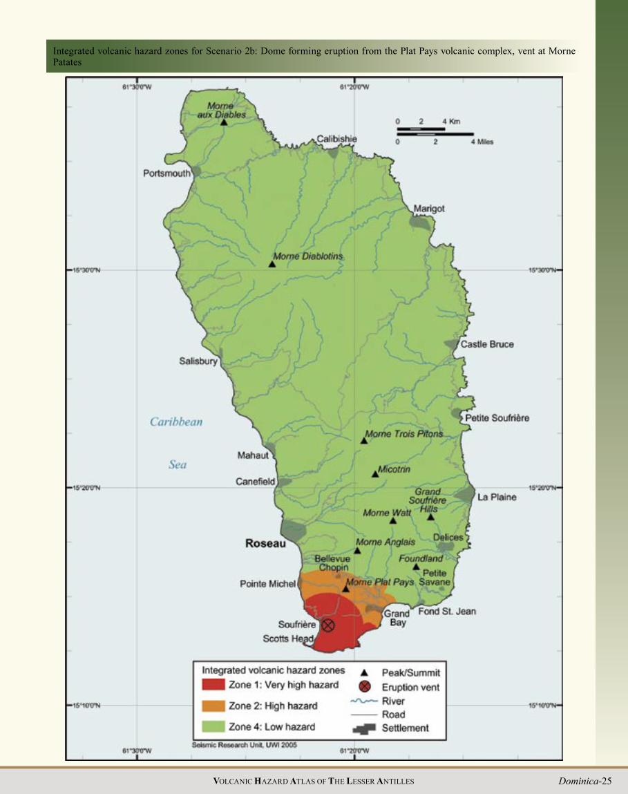
which will provide a more accurate estimate of vent location, it is difficult to say with certainty where activity will occur. Shifts in the vent location within the complex would not greatly alter the hazard map unless the vent was located to the south of Morne Plat Pays, e.g. from the Morne Patates region. Morne Patates is, in fact, the site of the most recent magmatic eruptions in Dominica, and a second hazard map based on this possible vent location is also presented here (scenario 2b).
The scenario of a dome-forming eruption from the vicinity of Morne Canot is considered the most likely for a future magmatic eruption in Dominica. The initial phases of the eruption may involve either non-explosive, passive eruption of lava to form a mound or hill (similar to, but possibly bigger than Morne Canot) or a period of vigorous ‘vent-clearing’ explosive magmatic activity followed by passive extrusion of lava. Either scenario for this initial phase is likely to be preceded by a series of phreatic eruptions, and the latter scenario may even generate sizable pyroclastic flows and surges. Once the lava dome is established and begins to grow, it may become oversteepened and unstable, causing it to periodically collapse and generate pyroclastic flows. In addition, explosive activity may occur periodically during dome-formation, possibly triggering explosive dome-collapse events as well as abundant ash and ballistic projectiles. A style of eruption involving dome growth and periodic collapse interspersed with small explosions is typified by the ongoing eruption on Montserrat. The likely duration of an eruption of this sort is between one and ten years.
The greatest hazard of a dome-forming eruption is from lava dome collapse (either gravitational or explosive) producing pyroclastic flows and surges with accompanying ash fall. For a vent located at Canot, dome-collapse pyroclastic flows could affect a large area surrounding and including Bellevue Chopin. Dome-collapse pyroclastic flows would almost certainly flow down the valleys leading to Pointe Michel, Loubiere, Pichelin and Grand Bay. The surges from these would extend to higher elevations and may overtop valley walls, spread out at the coast, and/or pour up side valleys for distances of a few hundred meters. Infrequent explosions or lateral blasts could generate more mobile pyroclastic flows and surges that could additionally reach Soufrière and Stowe. In an eruption with the vent at Morne Patates, however, Soufrière and Scotts Head would fall in the zone of high pyroclastic flow/surge hazard, and the likely impact on Point Michel, Bellevue Chopin and Grand Bay would be significantly reduced.
Volcanic explosions and pyroclastic flows and surges generate large amounts of volcanic ash, and ash fall is the most widespread of any volcanic hazard. The distribution of ash fall will be controlled by the height of the ash cloud together with the dominant wind direction. Ash clouds above pyroclastic flows will be restricted to lower elevations (less than about 5 km), whereas those generated by explosive eruptions will reach much higher elevations. In the case of Dominica, the dominant wind direction is from the east (easterlies) at lower elevations (< about 4-12 km, depending on time of year), and from the west (westerlies) at higher elevations (up to 17-18 km, above which are the stratospheric easterlies). Ash may travel for kilometres and affect neighbouring islands and at times severely disrupt air traffic. Atmospheric effects in ash clouds would generate frequent
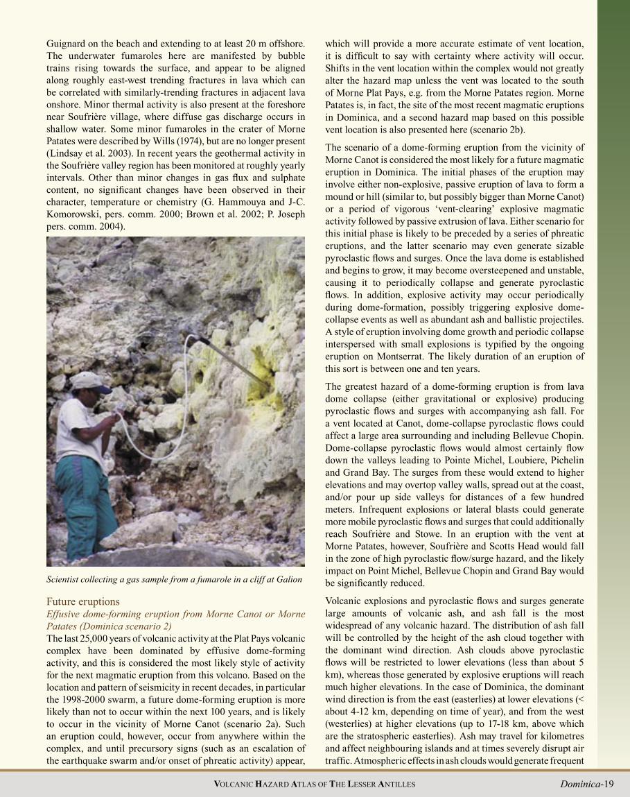
Guignard on the beach and extending to at least 20 m offshore. The underwater fumaroles here are manifested by bubble trains rising towards the surface, and appear to be aligned along roughly east-west trending fractures in lava which can be correlated with similarly-trending fractures in adjacent lava onshore. Minor thermal activity is also present at the foreshore near Soufrière village, where diffuse gas discharge occurs in shallow water. Some minor fumaroles in the crater of Morne Patates were described by Wills (1974), but are no longer present (Lindsay et al. 2003). In recent years the geothermal activity in the Soufrière valley region has been monitored at roughly yearly intervals. Other than minor changes in gas flux and sulphate content, no significant changes have been observed in their character, temperature or chemistry (G. Hammouya and J-C. Komorowski, pers. comm. 2000;; Brown et al. 2002;; P. Joseph pers. comm. 2004).
20 VOLCANIC HAZARD ATLAS OF THE LESSER ANTILLES
lightning strikes near and downwind of the vent. Ash fall will be thickest close to the vent and will decrease in thickness away from the vent. The pattern of accumulated ash fall thickness and distribution exhibited between 1995 and 2001 by the ongoing eruption of the Soufrière Hills Volcano in Montserrat (Norton et al. 2001) has been used to defi ne the probable ash fall pattern on the two hazard maps for this scenario. Ballistic projectiles may also be generated during small explosions or the explosive collapse of a volcanic dome and would mainly affect an area within 5 km of the vent, possibly reaching the island’s capital of Roseau as well as Grand Bay and Soufrière within 60 seconds
INTEGRATED VOLCANIC HAZARD ZONESTHE AREAS M OST LIKELY TO BE AFFECTED BY SPECIfi C HAZARDS IN THE VARIOUS SCENARIOS PRESENTED IN THIS CHAPTER HAVE BEEN USED TO DEfi NE INTEGRATED VOLCANIC HAZARD ZONES FOR EACH SCENARIO WHICH PROVIDE AN INDICATION OF OVERALL HAZARD IN THE ISLAND IN THE EVENT THAT THE ERUPTION IN THAT PARTICULAR SCENARIO OCCURS. BELOW IS A DESCRIPTION OF THESE ZONES, AND HOW THEY WERE DEfi NED.For dome-forming eruptions (scenarios 2, 4 and 6)Zone 1 (red) is the area of very high hazard. This is the area most likely to be affected by the dome itself, dome-collapse pyroclastic fl ows and surges, heavy ash fall, lahars and ballistic ejecta. It was determined by combining the following from the hazard map of the relevant scenario: the area with a high pyroclastic fl ow hazard, the 3 km radius ballistic projectile zone and the area likely to receive >30 cm of ash. Total destruction of buildings and property in Zone 1 is probable. This zone will need to be evacuated before the eruption begins. Zone 2 (orange) is the area of high hazard. It is the area likely to be affected by energetic dome-collapse pyroclastic fl ows and surges, ballistic ejecta, lahars and high to moderate ash fall. It was determined by combining the following from the relevant scenario: the area with a moderate pyroclastic fl ow hazard, the 5 km radius ballistic projectile zone and the area likely to receive 10-30 cm of ash. Zone 3 (yellow) is the area of moderate hazard. This zone may be affected by airfall but should be free from the effects of pyroclastic fl ows, surges, lahars and ballistic ejecta. It was determined by outlining the area likely to receive 5-10 cm of ash. Zone 4 (green) is regarded as the area of low hazard in which little to no direct effect of the volcano will be felt with the exception of some minor (<5 cm) airfall.For explosive eruptions (scenarios 3 and 5)Zone 1 (red) is the area of very high hazard. This is the area most likely to be affected by column-collapse pyroclastic fl ows and surges, heavy ash fall, lahars and ballistic ejecta. It was determined by combining the following from the hazard map of the relevant scenario: the area with a high pyroclastic fl ow hazard, the 3 km radius ballistic projectile zone and the area likely to receive >30 cm of ash fall. In the event of an explosive magmatic eruption total destruction of buildings and property in Zone 1 is probable. This zone will need to be evacuated before the eruption begins. Zone 2 (orange) is the area of high hazard. It is the area likely to be affected by energetic pyroclastic fl ows, surges and ballistic ejecta, lahars, and high to moderate ash fall. It was determined by combining the following from the relevant scenario: the area with a moderate pyroclastic fl ow hazard, the 5 km radius ballistic projectile zone and the area likely to receive 10-30 cm of ash fall. Zone 3 (yellow) is the area of moderate hazard. This zone may be affected by ash fall but should be free from the effects of pyroclastic fl ows, surges, lahars and ballistic ejecta. It outlines the area likely to receive 5-10 cm of ash. Zone 4 (green) is regarded as the area of low hazard in which little to no direct effect of the volcano will be felt with the exception of some minor (<5 cm) airfall. Note that in the integrated hazard zone map for scenario 5, Zone 1 also includes the area likely to be affected by scenario 1, i.e. a phreatic or hydrothermal eruption from the Valley of Desolation. In the event of scenario 1, only areas near to the vent will be affected. If, however, a sequence of phreatic explosions occurs accompanied by an earthquake swarm, some areas in the red zone may be evacuated in case the explosions represent precursor activity to a magmatic eruption.
Estimates of the probability of a magmatic eruption from the Plat Pays volcanic complex ( Dominica scenario 2) on various time scales ( Seismic Research Unit 2000)
Time scale(from 1 May. 2000)
Probability Remarks
One month Very lowIntensifi cation of
precursory phenomena expected before
eruptionOne year 1 in 50 The probability will
change when intense precursory phenomena
resume
Ten years 1 in 5100 years More likely than not800 years Certain
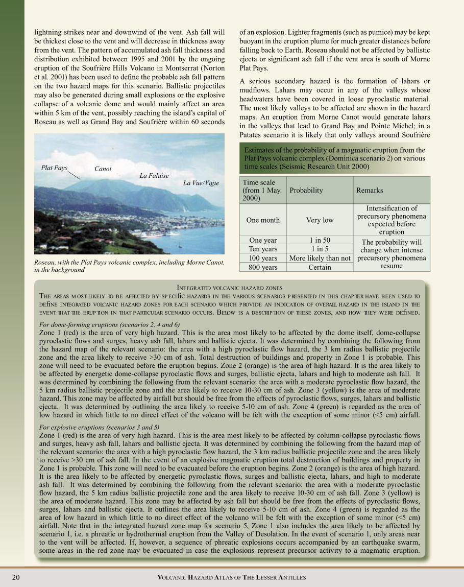
Roseau, with the Plat Pays volcanic complex, including Morne Canot, in the background
Plat Pays Canot La Falaise
La Vue/Vigie
of an explosion. Lighter fragments (such as pumice) may be kept buoyant in the eruption plume for much greater distances before falling back to Earth. Roseau should not be affected by ballistic ejecta or signifi cant ash fall if the vent area is south of Morne Plat Pays.
A serious secondary hazard is the formation of lahars or mudfl ows. Lahars may occur in any of the valleys whose headwaters have been covered in loose pyroclastic material. The most likely valleys to be affected are shown in the hazard maps. An eruption from Morne Canot would generate lahars in the valleys that lead to Grand Bay and Pointe Michel;; in a Patates scenario it is likely that only valleys around Soufrière

Dominica-21VOLCANIC HAZARD ATLAS OF THE LESSER ANTILLES
Volcanic hazard map for Scenario 2a: Dome-forming eruption from the Plat Pays volcanic complex, vent at Morne Canot

22 VOLCANIC HAZARD ATLAS OF THE LESSER ANTILLES
Integrated volcanic hazard zones for Scenario 2a: Dome forming eruption from the Plat Pays volcanic complex, vent at Morne Canot

Dominica-23VOLCANIC HAZARD ATLAS OF THE LESSER ANTILLES
would be affected. Volcanic earthquakes always accompany volcanic eruptions and in themselves may be severe enough to cause damage. Volcanic earthquakes are not predictable and will occur without warning. They may also occur when the volcano is not currently erupting and are thus a serious potential hazard at all times.
Another possible scenario: explosive eruption from Morne Plat PaysThe 6.8 ka old andesitic pyroclastic flow deposit (Asama style activity) exposed on the flanks of Morne Plat Pays indicates that explosive magmatic eruptions have occurred from this centre in the recent past, and may occur here again in the future. A similar eruption in the future may produce a low eruption column, collapsing a few hundreds of meters above the vent. Collapse of such a low column may generate pyroclastic flows and surges radially around the volcano, but would not produce significant ash fall. Ballistic projectiles would be a hazard within ~5 km of the vent, and lahars and volcanic earthquakes could also occur. Such an eruption would affect an area radially around Morne Plat Pays and could potentially impact a greater area than a dome-forming eruption.
Morne Anglais/JohnMorne Anglais is a prominent peak located just to the east of Roseau. It is a stratovolcano with a prominent summit dome. Morne John, a single Pelean dome with its own apron of block and ash flows, lies on its northeastern flank.
Past eruptive activityDemange et al. (1985) describe three stages of past activity at Morne Anglais. Stage 1 involved a period of dome growth and collapse, resulting in a series of block and ash flow deposits. A period of St. Vincent style activity occurred during Stage 2, producing a sequence of basaltic-andesite scoria and ash flow, scoriaceous surge and scoriaceous fall deposits, some of which contain evidence of magma co-mingling. These deposits are exposed intermittently along the west coast and in roadcuts to the west and southwest of the volcano. A sequence of scoriaceous deposits exposed within the Soufrière depression and dated at 28,450 (Wadge 1985) and 26,400 (Demange et al. 1985) years BP may possibly be correlated with these deposits. The most recent major phase of activity, stage 3, was again characterised by dome growth and collapse, and resulted in the present
morphology of a central Pelean dome complex surrounded by aprons of block and ash flow deposits. A block from one of the Anglais block and ash flow deposits gave a K-Ar age of 0.43 Ma, which, based on morphological criteria and the possible presence of excess argon, is thought to be too old (Demange et al. 1985). The western and southern flanks of Morne Anglais contain outcrops of an undated andesitic pumice and ash-rich pyroclastic flow deposit <2 m thick that represent a period of explosive activity and are thought to be the youngest deposits from Anglais (Lindsay et al. 2003). Very little is known about the age and nature of Morne John.
Historical eruptionsThere have been no reports of historical eruptions from Morne Anglais or Morne John.
SeismicityFrom September 1998 to July 2000 Dominica experienced a major earthquake swarm associated with the Plat Pays volcanic complex and the Morne Anglais/John centre. Details of this swarm are discussed above in the section on seismicity of the Plat Pays volcanic complex.
Geothermal activityThere is no known geothermal activity associated with the Morne Anglais/John centre.
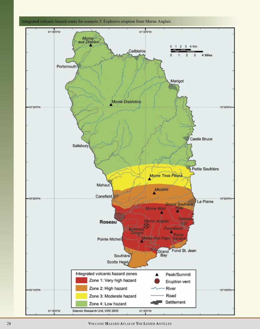
Future eruptionsExplosive eruption from Morne Anglais (Dominica scenario 3) The proximity of Morne Anglais to the recent volcanic earthquake swarm, and in particular the cluster of earthquakes directly beneath its summit, indicate that eruptions are likely to occur from here in the future. The most recent activity at Morne Anglais has been explosive in nature (Lindsay et al. 2003), and St. Vincent style explosive activity occurred extensively during Stage 2. The most likely future activity at this centre is therefore considered to be an explosive andesitic or basaltic magmatic eruption, possibly preceded by a period of phreatic activity. The vent would probably be located at or near the summit, as in past eruptions.
Such an eruption would generate a buoyant eruption cloud of ash and larger rock fragments, which may subsequently collapse to generate pumiceous pyroclastic flows and surges in all directions around the vent, particularly down all major nearby valleys including the Roseau and Geneva rivers and their tributaries (brown area on the hazard map). Less frequent but more energetic pyroclastic flows and surges from either column collapse or a rare but devastating lateral blast would be less restricted by topography and would have the potential to cover greater areas and may even reach as far south as Soufrière and as far north as Massacre to the west and Boetica to the east (yellow area on the hazard map). In the absence of ash fall data specific to Morne Anglais, the pattern of ash fall thickness and distribution exhibited during the 1902 eruption of the Soufrière in St. Vincent (Robertson 1992) has been used to define a possible ash fall pattern. Note that if the eruption column is lower than that generated during the 1902 St. Vincent eruption, the ash fall distribution may only be affected by the trade winds and thus be concentrated to the west of the volcano (e.g. Roobol et al. 1985). Whichever the case, copious amounts of ash would fall downwind from the volcano. Ballistic projectiles would
View of Morne Anglais from the northeast

24 VOLCANIC HAZARD ATLAS OF THE LESSER ANTILLES
Volcanic hazard map for Scenario 2b: Dome-forming eruption from the Plat Pays volcanic complex, vent at Morne Patates
Dominica-25VOLCANIC HAZARD ATLAS OF THE LESSER ANTILLES
Integrated volcanic hazard zones for Scenario 2b: Dome forming eruption from the Plat Pays volcanic complex, vent at Morne Patates

26 VOLCANIC HAZARD ATLAS OF THE LESSER ANTILLES
be common and would mainly affect an area within 5 km of the vent. Lighter fragments (such as pumice or scoria) may be kept buoyant in the eruption plume for much greater distances before falling back to Earth. The explosive phase of the eruption may be followed by rapid extrusion of a lava dome. Lahars and volcanic earthquakes would also occur, and may continue long after the eruption itself has ended. Such an explosive eruption may last for years but could also be short-lived (weeks to months). Whatever the duration, areas affected by the eruption will remain uninhabitable for many years.
There have been several periods of dome growth and collapse at Morne Anglais in the past, and this type of activity may also occur in the future. A scenario involving a dome-forming eruption from Anglais would not signifi cantly alter the hazard map, although the area affected by pyroclastic fl ows and surges would be smaller and more concentrated on the west of the volcano, due to the presence of channelling river valleys to the west and topographic highs to the east.
Wotten Waven/ MicotrinThis centre comprises the Wotten Waven caldera (the southernmost caldera within the Central Graben) together with the twin Pelean domes and associated craters of Micotrin. The Wotten Waven caldera was fi rst identifi ed by Demange et al. (1985), who described it as a vast ‘volcano-tectonic depression’ thought to have formed as a result of withdrawal of magma due to the eruption of the large volume of ignimbrite that forms Unit 1 of the Roseau Tuff. The caldera is elongated SW-NE, parallel to the chain of Pelean volcanoes that bound the southern margin of the Central Graben. It is approximately 7 km long and 4.5 km
wide, and parts of the margin are fault controlled. Subsidence volume has been estimated at 5-7.7 km3 (Demange et al. 1985). The two coalesced domes of Micotrin, located in the caldera near its northeastern margin, lie within a number of craters, the largest of which has a diameter of 3.5 km. Between the crater rim and the domes is a “moat” which is now fi lled in places by lakes (e.g. the Boeri and Freshwater lakes).
Past eruptive activityThis centre has exhibited a variety of past eruptive activity. Activity between 40 and 20 ka was characterised by large explosive Plinian eruptions generating ignimbrites;; more recent activity has taken the form of Pelean dome-forming eruptions producing block and ash fl ows and smaller pumiceous pyroclastic fl ows.
The Roseau TuffThe Roseau Tuff is a thick sequence of ignimbrites (partly welded), pumiceous surges and pumice lapilli fall deposits (Sigurdsson 1972) that crops out in the area between the Micotrin dome and the west coast at Roseau. The source for the Roseau Tuff is not well known. Sigurdsson (1972) proposed vents under the Micotrin/Trois Pitons domes, whereas Demange et al. (1985) proposed that much of the ignimbrite originated from within the Wotten Waven caldera.
The Plinian eruptions that produced the Roseau Tuff are thought to have occurred over a >20,000 year period (from >46,000 to ~25,000 years BP) (Sigurdsson 1972;; Carey and Sigurdsson 1980;; Demange et al. 1985;; Sigurdsson and Carey 1991). Demange et al. (1985) divided the Roseau Tuff in the Roseau valley into three distinct ignimbrite units separated by paleosols. Unit 1
THE CENTRAL GRABEN OF DOMINICA
The Central Graben and associated features

Dominica-27VOLCANIC HAZARD ATLAS OF THE LESSER ANTILLES
Volcanic hazard map for Scenario 3: Explosive eruption from Morne Anglais
28 VOLCANIC HAZARD ATLAS OF THE LESSER ANTILLES
Integrated volcanic hazard zones for scenario 3: Explosive eruption from Morne Anglais

Dominica-29VOLCANIC HAZARD ATLAS OF THE LESSER ANTILLES
comprises mainly welded deposits not underlain by a Plinian fall layer, thought to have formed by an “instantaneous” column collapse (e.g. Cas and Wright 1987) from either a crater or an elongated fissure within the Wotten Waven caldera (Demange et al. 1985). Pyroclastic flows from this eruption were largely canalised into a paleovalley between the Trois Pitons and Morne Anglais volcanoes and their deposits are largely confined to within the current Wotten Waven caldera. Unlike Unit 1, Unit 2 was preceded by Plinian fall activity, with fall layers also being interbedded within the ignimbrite sequence. The distribution of these deposits suggests a source in the general area between Du Mas estate and Micotrin, and they may have originated from the craters beneath Micotrin. Unit 2 deposits, well exposed in the Goodwill quarry area, have a much greater aerial extent but smaller volume than Unit 1. Unit 3 is distinct from Units 1 and 2 in that, in addition to pumiceous deposits, it also contains extensive block and ash flow deposits that appear to have originated from Micotrin. In most cases these overlie the pumiceous deposits, suggesting that the explosive activity of Unit 3 terminated with the extrusion of a Pelean dome and the generation of associated block and ash flows. The craters beneath Micotrin probably represent the source for the ignimbrites of Unit 3.
Grand Bay ignimbrite, Grand Bay beach
Other large ignimbrite-producing eruptionsWithin southern Dominica there are other ignimbrite sequences with similar ages to the Roseau Tuff, suggesting that they may also be associated with these Plinian eruptions. These include thick ignimbrite sequences on the east coast at Grand Fond and Rosalie, and on the south coast at Grand Bay. If these ignimbrites indeed had a similar source area to the Roseau Tuff,
then the former may have overtopped ridges north of Morne Watt (now covered by the domes of Trois Pitons and Micotrin), whereas the latter, termed the Grand Bay ignimbrite by Lindsay et al. (2003) and thought by them to have originated from the Plat Pays volcanic complex, may have flowed over a low divide between Morne Watt and Morne John and down the Perdu Temps river valley to reach the present coast at Grand Bay. A submarine fan extending at least 7 km offshore is thought to represent an offshore extension of the Grand Bay ignimbrite (Lindsay et al. 2003). Lateral equivalents of the Grand Bay ignimbrite have been recognised along the south coast from west of Morne Fous to Petite Savane in the east (Lindsay et al. 2003). Another Plinian sequence composed of ignimbrites, pumiceous surges and one fall layer of similar age to the Roseau ignimbrites (38,610 to 30,270 years BP), has been described from the Wall House quarry on the western flanks of Morne Anglais. The source of these pyroclastic deposits is unclear;; Lindsay et al. (2003) suggested they represent a distal facies of the Grand Bay ignimbrite, but they may also represent products of a contemporaneous eruption from Wotten Waven or Morne Anglais. If the Wotten Waven/Micotrin centre is the source area for all major ignimbrites in southern Dominica, then the 17 available radiocarbon dates from the Roseau, Grand Fond-Rosalie and Grand Bay tongues, together with field relations, suggest that this major Plinian eruptive sequence can, in fact, be subdivided into 6 possible phases of activity: ~25,000;; ~29,000;; ~35,000;; ~38,000;; ~46,000 and >46,000 years BP.
After the emplacement of the Roseau Tuff and associated ignimbrites, activity continued from the Wotten Waven/Micotrin area as indicated by an ignimbrite at En Bas Petit Fond (Ma Robert) on the east coast dated at 19,500 years BP, and the occurrence south of Micotrin of deposits from small Plinian and Pelean eruptions that occurred approximately 1,000 years ago. The latter represents the most recent activity associated with the Wotten Waven caldera and may have originated from the Micotrin domes or other unrecognised vents associated with the caldera margin.
Historical eruptions There have been no reports of historical eruptions from the Wotten Waven/Micotrin centre.
SeismicityMuch of the pre-1997 as well as more recent (e.g. 2002) seismicity in southern Dominica appears to underlie the Wotten Waven caldera. Occasional volcanic earthquakes also occur beneath Micotrin.
Geothermal activityWotten WavenSeveral fumaroles and hot springs are located within the Wotten Waven caldera. The largest area of activity is located near the village of Wotten Waven, in and adjacent to the River Blanc, a tributary of the Roseau river. Within the river valley itself there are numerous bubbling pools and fumaroles with temperatures of up to 99o C. A 2 m wide cave approximately 6 m above the river bed on the northern side of the river is the site of a milky-white pool of water (80-93o C) whose level rises and falls every 10 seconds. Loud bubbling sounds issue from within the depths of the cave. About 40 m north of the cave, above the River

30 VOLCANIC HAZARD ATLAS OF THE LESSER ANTILLES
Scientist collecting a water sample from the Yellow Pool, Wotten Waven, May 2000
Blanc, several other vigorously bubbling pools are present. The largest of these, Yellow Pool, is ca. 2 m x 1.5 m in size, and is milky white or clear, depending on whether it is the dry or wet season, respectively. Its temperature also varies according to season: 71-74o C in the wet season, and 87-93o C in the dry season (Joseph and Lindsay 2002). Several other smaller pools in and adjacent to a small stream that passes through the area range in temperature from 50 to 99o C. A fumarole in a nearby field had a temperature of 100o C in May 2000. An old report by Drumm (1849) on the Wotten Waven geothermal area suggests it was just as active, if not more active, 150 years ago.
The Boeri Lake, with the northern Micotrin dome (left) and surrounding crater rim (right and background)
Sketch map of some geothermal features of Wotten Waven
Future eruptionsDome-forming eruption from Morne Micotrin (Dominica scenario 4)The recognition of relatively recent (~1 ka) Pelean and Plinian activity associated with Micotrin, together with the proximity to historical seismicity, indicates that the Wotten Waven/Micotrin centre could be the site of future eruptions. The most recent activity from this centre has occurred from the Micotrin dome complex, and this is considered the most likely vent area for future eruptions. Recent past behaviour at this volcano indicates that future activity is most likely to be dome forming. The type and duration of hazardous phenomena associated with such an eruption would be similar to that described for a dome-forming eruption from the Plat Pays volcanic complex. The phase of effusive dome-forming activity is likely to be preceded by a series of phreatic eruptions, and possibly even by a period of ‘vent-clearing’ explosive magmatic activity. Dome collapse pyroclastic flows and surges could occur down major valleys on both sides of the volcano, and reach the sea at Roseau and Canefield to the west and Rosalie on the east (brown area on the hazard map). The town of Roseau is, in fact, built on top of a pyroclastic flow fan which was produced during past eruptions at the Wotten Waven/Micotrin centre. More energetic pyroclastic flows and surges from explosive dome collapse events or rare but devastating lateral blasts would not be so constrained by topography and may reach as far as Mahaut, Loubiere and La Plaine (yellow area on hazard map). Ballistic projectiles would typically be a hazard within ~5 km of the vent, and lahars and volcanic earthquakes could also occur. The pattern of accumulated ash fall thickness and distribution exhibited between 1995 and 2001 by the ongoing eruption of the Soufrière Hills Volcano in Montserrat (Norton et al. 2001) has been used to define the probable ash fall pattern on the hazard map for this scenario. Ash would fall in copious amounts downwind from the volcano.
Explosive Plinian eruption from the Wotten Waven caldera: (Dominica scenario 5)Although the last Plinian eruptions from the Wotten Waven caldera probably occurred >19 ka ago, the vigorous geothermal activity at Wotten Waven, together with shallow seismicity beneath the caldera and the possibility that the Plinian eruptions around 1 ka were from vents on the caldera boundary faults, indicates that the possibility of a future Plinian eruption from this centre must be considered. The Wotten Waven caldera is a
Minor warm spring activity is also present at the Trafalgar Falls in Papillote, and a temperature of 39.2o C was recorded by van Soest et al. (1998). A landslide in September 1995 buried the pools and hot spring at the base of the ‘father falls’ (James 1997) impeding access to this once-popular tourist destination.
MicotrinAlthough there are no major areas of geothermal activity associated with Micotrin, some of the streams flowing down the east side of the southern dome are warm and have banks with patches of orange-stained rocks, indicating that there are some as yet unidentified warm springs higher up the dome.

Dominica-31VOLCANIC HAZARD ATLAS OF THE LESSER ANTILLES
Volcanic hazard map for Scenario 4: Dome-forming eruption from Micotrin

32 VOLCANIC HAZARD ATLAS OF THE LESSER ANTILLES
Integrated volcanic hazard zones for Scenario 4: Dome-forming eruption from Micotrin

Dominica-33VOLCANIC HAZARD ATLAS OF THE LESSER ANTILLES
Morne Diablotins and Morne aux Diables Both Morne Diablotins and Morne aux Diables comprise eroded Pelean domes and deeply gullied pyroclastic aprons. Morne Diablotins is the largest and highest volcanic centre on Dominica, and is the second highest mountain in the Eastern Caribbean (La Soufrière in Guadeloupe is the highest). Measuring 22 km x 18 km at its base and rising to a height of 1,421 m, it dominates the northern part of the island. Morne aux Diables, forming a peninsula at the extreme north of the island, comprises a central complex of eroded Pelean domes and craters surrounded by flanks of dominantly lithified block and ash flow deposits.
Welded ignimbrite (the Roseau Tuff) in the Roseau River valley. Note columnar jointing at top of cliff
View of Morne Diablotins from the northwest, with Portsmouth in the foreground
Past eruptive activity DiablotinsMorne Diablotins is a composite structure comprising several superimposed stratigraphic units. The ‘Older Pleistocene’ volcano, believed to have been very similar to Morne Trois Pitons and Micotrin in form, underwent extensive Pelean activity producing block and ash flows and andesite lava flows (Martin-Kaye 1960;; Wadge 1989). A single age of 1.77 Ma (Bellon 1988) from an andesite lava flow has been obtained from these extensive deposits. Pelean-style eruptions also characterise the ‘Younger Pleistocene’ to Recent activity of Morne Diablotins, with block and ash flows reaching the southwest, northwest and northeast coasts. Available ages for these deposits range from 0.72 Ma (Monjaret 1985) to >46,620 years BP (Smith and Roobol unpublished data). This Pelean activity was followed by explosive Plinian activity that produced pumiceous fall deposits and ignimbrites dated from >22,200 to >40,000 years BP (Sparks et al. 1980a,b;; Wadge 1989). The ignimbrite deposits form five radial tongues around the volcano, and have been referred to as the Grand Savanne ignimbrite (Sparks et al. 1980a). The ignimbrites on the wetter Atlantic coast are weathered yellow and lithified, while those on the drier Caribbean coast remain white and unlithified, although at Grand Savanne they show welding (Sparks et al. 1980a). These pumiceous deposits are overlain by unconsolidated block and ash flow deposits, which are well exposed in two valley infills on the west coast near Pointe Crabier and Coulibistri.
A summit caldera several km in diameter, similar to those beneath Morne Trois Pitons and Micotrin, may have developed during this Plinian activity, but any evidence for this is now hidden beneath a central Pelean dome complex of at least five domes. The domes occupy an area of 6 km E-W and 4 km N-S
volcano-tectonic depression that in all likelihood has boundary faults extending to depth. Such a depression may hydrostatically attract any rising head of magma, with the boundary faults providing easy access to the surface. A reactivation of the Wotten Waven caldera could produce a major explosive eruption which would affect most of Dominica. Plinian activity is the most explosive type and results from gas-rich felsic magma that has differentiated in a high-level magma chamber. Such an eruption must be considered the worst-case scenario for a future eruption in Dominica.
Plinian eruption columns can reach altitudes of 50 km, although most are lower, generally in the 10-20 km range, so that the material is dispersed by both upper and lower tropospheric winds (Trades and Anti-Trades) as well as by the stratospheric easterlies. The pattern of ash fall thickness and distribution exhibited during the 1902 eruption of the Soufrière in St. Vincent (Robertson 1992) has been used to define a possible ash fall pattern. The collapse of a high Plinian eruption column rich in ash would result not only in ash fall over a wide area, but also extensive valley-fill ignimbrites and associated ash-rich surges (brown area on the hazard map), the latter representing the greatest hazard. Such surges would travel extensively;; the pumiceous surges (or ‘ash hurricanes’) produced by prehistoric eruptions of Mt. Pelée extended at least 12 km south of the crater to the very outskirts of the island capital of Fort de France (Smith and Roobol 1990). All major surrounding valleys would be affected, including the Roseau river and its tributaries. Whereas Morne Trois Pitons and Micotrin would provide some morphological barrier to the north and east of the Wotten Waven caldera, there is no barrier to the west, and ash surges are likely to travel in that direction unimpeded. Energetic surges could also expand to the northeast and devastate the entire central part of the island (yellow area on the hazard map). Morne Diablotins and a ridge of older volcanic rocks to its southeast (see relief map) are likely to form a barrier to the far north;; to the south, however, the surges are likely to jump over lower volcanoes and to pass through gaps between them so that most of the island would be devastated. Such an eruption would also produce extensive ballistic projectiles, lahars, volcanic earthquakes and lightning strikes. In such a scenario most of the island south of a line connecting the towns of Salisbury and Marigot would fall in the very high and high integrated hazard zones.

34 VOLCANIC HAZARD ATLAS OF THE LESSER ANTILLES
Volcanic hazard map for Scenario 5: Explosive Plinian eruption from the Wotten Waven caldera
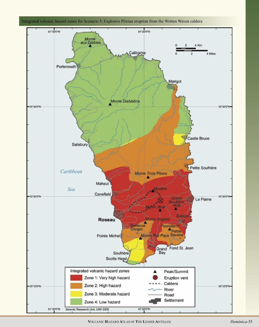
Dominica-35VOLCANIC HAZARD ATLAS OF THE LESSER ANTILLES
Integrated volcanic hazard zones for Scenario 5: Explosive Plinian eruption from the Wotten Waven caldera

36 VOLCANIC HAZARD ATLAS OF THE LESSER ANTILLES
and are surrounded by aprons of block and ash flow deposits. A single K-Ar age determination of 0.7 Ma was obtained by Wadge (1989) for one of the Morne Diablotins domes. This age may, however, be too old due to 40Ar contamination from magmatic gases (Wadge 1989).
The whole of the above complex sits unconformably on the laterite-saprolite surface developed on the Pliocene volcanic rocks that crop out on all sides of the volcano. The Pliocene deposits forming the basement to Morne Diablotins can be subdivided into a submarine and a subaerial stage. Deposits belonging to the former have been dated between 3.7 and 3.4 Ma (Bellon 1988), whereas the latter include thick subaerial andesitic lava flows dated at around 2.2 Ma (Bellon 1988). The Pliocene deposits themselves overlie Miocene deposits that are exposed on the east coast.
Morne aux DiablesMorne aux Diables is a stratovolcano measuring 7 km by 7 km and rising to a height of 856 m. Its northern boundary is a steep, 3.8 km-long linear cliff oriented E-W, suggesting a fault scarp. This volcano is composed of a central complex of eroded faceted Pelean domes from which dominantly lithified block and ash flow deposits radiate out in all directions to form the flanks. There are five parasitic domes that form an east-west belt across the southern flanks. One of these at West Cabrits is now linked to the island by beach deposits and a swamp. Although the stratigraphy exposed in the sea cliffs is dominated by block and ash flow deposits, a section measured near Douglas Point shows lithified ignimbrites, pumiceous surge deposits and lapilli fall beds that are overlain by lithified semi-vesicular block and ash flow and surge deposits. These indicate that, in addition to the dominant Pelean activity, this centre has also undergone Plinian- and Asama-style activity.
Three K-Ar ages of 1.68, 1.72 and 2.01 Ma (Monjaret 1985;; Bellon 1988) show Morne aux Diables to be essentially of ‘Older Pleistocene’ age. Despite this, there is considerable evidence for rejuvenation during the Late Pleistocene to Holocene. Three tongues of unconsolidated block and ash flow deposits extend to the northwest coast and two to the northeast coast;; such unconsolidated pyroclastic deposits in the Lesser Antilles are believed to be younger than about 70,000 years (Smith and Roobol 1990). One of these tongues exposed in a new road section on the east coast near the hamlet of Enbas (north of Vieille Case) contains pieces of non-charred wood up to 30 cm long, which have yielded a radiocarbon age of >46,740 years BP.
Morne aux Diables complex looking northeast from Portsmouth
Unconsolidated block and ash flow deposits associated with the East Cabrit dome on the west coast also indicate a young age. The presence of these unconsolidated pyroclastic deposits suggests that the Morne aux Diables volcano has been rejuvenated during the Late Pleistocene to Holocene, resulting in the formation of young Pelean domes near the current summit and on the western flank.
Historical eruptions There have been no reports of historical eruptions from either Morne Diablotins or Morne aux Diables.
Seismicity Although most of the historical earthquake swarms in Dominica have occurred in the south of the island, there have also been several periods of intense activity in the north;; in 1841, 1893, and more recently in 2000 and 2003. The most intense of theses occurred in April 2003, when more than 500 earthquakes were recorded in less than a week. It is likely that the earthquakes recorded (and also strongly felt) during both this swarm and that of 2000 were volcanic in nature.
The northern network was upgraded after the 2000 swarm, allowing locations for the subsequent swarm to be determined. Most of the epicentres of 2003 cluster in an arcuate zone measuring 10 km from north to south and which opens to the west. This zone includes the Morne aux Diables volcano as well as the northern flanks of Morne Diablotins and may represent a ring fault associated with Morne aux Diables. Although some of the larger events do plot near the central vents of Morne aux Diables, the lack of unambiguous association with either of these two centres does make it difficult to determine the significance of these events.
Penville Cold Soufrière, Morne aux Diables: May 2003
Geothermal activityNumerous hot springs and patches of hot ground are present in the vicinity of Glanvillia south of Portsmouth. They form an area of thermal activity 2.5 km by 1.5 km in size, roughly half of which is immersed in the shallow waters of Prince Rupert Bay at depths of 20 to 70 ft. Onshore temperatures of up to 102 oC were recently (February 2004) recorded from an area of hot ground near the mouth of the Picard River in Glanvillia. The submarine springs occur as both large isolated springs and as areas of more diffuse degassing via many smaller springs. The largest and deepest solitary spring is located in 70 ft of water to the south of the thermal area. Vigorous venting of hot discoloured water from this feature has led to the formation of a depression in

Dominica-37VOLCANIC HAZARD ATLAS OF THE LESSER ANTILLES
the sea bed 110 ft in diameter. Bubbles from this spring reach the water surface despite the 70 ft water depth (compared to a maximum depth of origin of only 15 ft at Champagne Pool in the south). Divers visiting the area in February 2004 reported the sea bed too hot to push their hands into the sand and the boat anchor, when raised, was still warm to the touch.
Minor fumarolic activity has also been reported on the northwestern slopes of Morne Diablotins (Robson and Tomblin 1966), to the west of Morne aux Diables on the coast at Toucari village (in a roadside excavation now infilled) and on Morne Turner (A. James pers. comm. 2003). An area of cold spring activity, known as the ‘Penville Cold Soufrière’, is located in the northwestern, younger crater of Morne aux Diables (Robson and Tomblin 1966), in the upper part of the Lamothe River. The springs are located to the north of the main summit area, and cover an area of about 25 m2. The activity is manifested as milky to clear vigorously bubbling pools and cold “frying pan” features with temperatures of 23-29 oC and an acidic pH (1-2) (Joseph and Lindsay 2002;; Joseph and Robertson 2003). A strong H2S odour is present and vegetation is dead or absent in the immediate area. Several bubbling springs also occur in a nearby stream, and are surrounded by large patches of white filamentous algae.
Future eruptionsThe presence of unconsolidated pyroclastic deposits on Morne Diablotins and Morne aux Diables indicates that both these volcanoes may have been active into the Holocene. This, together with occasional shallow seismicity beneath these centres and the presence of a large area of heat escape at Glanvillia as well as other scattered areas of hot and cold spring activity in the area, suggests that these volcanoes may erupt again. The present seismic and geothermal activity is not convincingly associated with one or the other of these centres, but is more consistent with possible future activity at Morne aux Diables.
Penville Cold Soufrière, Morne aux Diables: February 2004
Effusive dome-forming eruption form Morne aux Diables (Dominica scenario 6)Although lithified deposits around Douglas Point indicate that Plinian and Asama style explosive activity has occurred during the ‘Older Pleistocene’ stage of Morne aux Diables, the resurgent Holocene activity at this centre has been restricted to Pelean-type eruptions, and a dome-forming eruption is therefore considered the most likely scenario for future activity at this centre. Past activity at Morne aux Diables indicates that a future dome could develop from either central or flank parasitic vents;; for the purpose of this scenario a central vent is assumed.
The type and duration of hazardous phenomena associated with such an eruption would be similar to that described for dome-forming eruptions from the Plat Pays volcanic complex and Micotrin (see above). The phase of effusive dome-forming activity is likely to be preceded by a series of phreatic eruptions and possibly even by a period of ‘vent-clearing’ explosive magmatic activity. Dome collapse pyroclastic flows and surges could occur down major valleys on all sides of the volcano and reach the sea at Portsmouth, Savane Paille and Clifton to the west, and Penville, Vieille Case and Hiroula Bay to the east (brown area on the hazard map). More energetic pyroclastic flows and surges from explosive dome collapse or rare but devastating lateral blasts would not be so constrained by topography and may reach Glanvillia in the southwest and affect areas in and around Thibaud to the east and Dos D’ane and La Source to the southeast (yellow area on hazard map). If the vent occurs on the western flank of the volcano, for example near The Cabrits or Portsmouth, towns to the east of the volcano such as Vieille Casse and Pennville are unlikely to be affected by pyroclastic flow and surge activity. Ballistic projectiles would typically be a hazard within ~5 km of the vent, and lahars and volcanic earthquakes could also occur. The pattern of accumulated ash fall thickness and distribution exhibited between 1995 and 2001 by the ongoing eruption of the Soufrière Hills Volcano in Montserrat (Norton et al. 2001) has been used to define the probable ash fall pattern on the hazard map for this scenario. Ash would fall in copious amounts downwind from the volcano.
Morne WattThe Morne Watt centre is dominated by Pelean domes surrounded by an apron of block and ash flow deposits. The top of the volcano is composed of at least three eroded coalesced Pelean domes with a total diameter of 1.8 km. Immediately to the east is an arcuate host crater rim with smooth outer flanks lacking deep erosion. A single parasitic Pelean dome occupies the eastern flanks, and the western flanks are largely covered by recent deposits from Morne Anglais and Morne John. The phreatic craters and hydrothermal features of the Valley of Desolation have formed to the northeast of Morne Watt in its lower flank deposits.
Past eruptive activityDemange et al. (1985) describe the western foundations of the volcano as comprising massive andesite lavas now exposed in the River Claire on Curbin Estate and in a little ravine west of Robinson Estate. An age of 0.46 Ma was obtained on a block from a breccia exposed on the northeastern flanks of the volcano. The smooth outer eastern flanks of Morne Watt, in association with the description of ignimbrites in the upper Jack River which

38 VOLCANIC HAZARD ATLAS OF THE LESSER ANTILLES
Volcanic hazard map for Scenario 6: Dome-forming eruption at Morne aux Diables

Dominica-39VOLCANIC HAZARD ATLAS OF THE LESSER ANTILLES
Integrated volcanic hazard zones for Scenario 6: Dome-forming eruption at Morne aux Diables
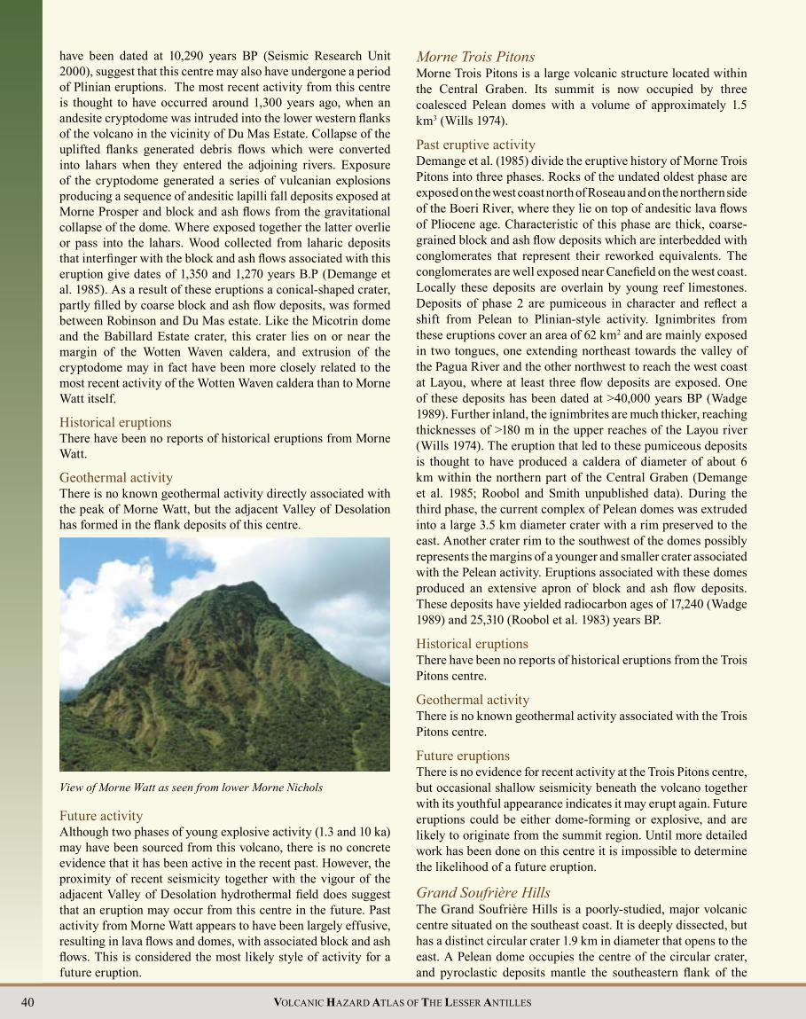
40 VOLCANIC HAZARD ATLAS OF THE LESSER ANTILLES
View of Morne Watt as seen from lower Morne Nichols
have been dated at 10,290 years BP (Seismic Research Unit 2000), suggest that this centre may also have undergone a period of Plinian eruptions. The most recent activity from this centre is thought to have occurred around 1,300 years ago, when an andesite cryptodome was intruded into the lower western flanks of the volcano in the vicinity of Du Mas Estate. Collapse of the uplifted flanks generated debris flows which were converted into lahars when they entered the adjoining rivers. Exposure of the cryptodome generated a series of vulcanian explosions producing a sequence of andesitic lapilli fall deposits exposed at Morne Prosper and block and ash flows from the gravitational collapse of the dome. Where exposed together the latter overlie or pass into the lahars. Wood collected from laharic deposits that interfinger with the block and ash flows associated with this eruption give dates of 1,350 and 1,270 years B.P (Demange et al. 1985). As a result of these eruptions a conical-shaped crater, partly filled by coarse block and ash flow deposits, was formed between Robinson and Du Mas estate. Like the Micotrin dome and the Babillard Estate crater, this crater lies on or near the margin of the Wotten Waven caldera, and extrusion of the cryptodome may in fact have been more closely related to the most recent activity of the Wotten Waven caldera than to Morne Watt itself.
Historical eruptions There have been no reports of historical eruptions from Morne Watt.
Geothermal activityThere is no known geothermal activity directly associated with the peak of Morne Watt, but the adjacent Valley of Desolation has formed in the flank deposits of this centre.
Morne Trois PitonsMorne Trois Pitons is a large volcanic structure located within the Central Graben. Its summit is now occupied by three coalesced Pelean domes with a volume of approximately 1.5 km3 (Wills 1974).
Past eruptive activityDemange et al. (1985) divide the eruptive history of Morne Trois Pitons into three phases. Rocks of the undated oldest phase are exposed on the west coast north of Roseau and on the northern side of the Boeri River, where they lie on top of andesitic lava flows of Pliocene age. Characteristic of this phase are thick, coarse-grained block and ash flow deposits which are interbedded with conglomerates that represent their reworked equivalents. The conglomerates are well exposed near Canefield on the west coast. Locally these deposits are overlain by young reef limestones. Deposits of phase 2 are pumiceous in character and reflect a shift from Pelean to Plinian-style activity. Ignimbrites from these eruptions cover an area of 62 km2 and are mainly exposed in two tongues, one extending northeast towards the valley of the Pagua River and the other northwest to reach the west coast at Layou, where at least three flow deposits are exposed. One of these deposits has been dated at >40,000 years BP (Wadge 1989). Further inland, the ignimbrites are much thicker, reaching thicknesses of >180 m in the upper reaches of the Layou river (Wills 1974). The eruption that led to these pumiceous deposits is thought to have produced a caldera of diameter of about 6 km within the northern part of the Central Graben (Demange et al. 1985;; Roobol and Smith unpublished data). During the third phase, the current complex of Pelean domes was extruded into a large 3.5 km diameter crater with a rim preserved to the east. Another crater rim to the southwest of the domes possibly represents the margins of a younger and smaller crater associated with the Pelean activity. Eruptions associated with these domes produced an extensive apron of block and ash flow deposits. These deposits have yielded radiocarbon ages of 17,240 (Wadge 1989) and 25,310 (Roobol et al. 1983) years BP.
Historical eruptionsThere have been no reports of historical eruptions from the Trois Pitons centre.
Geothermal activityThere is no known geothermal activity associated with the Trois Pitons centre.
Future eruptionsThere is no evidence for recent activity at the Trois Pitons centre, but occasional shallow seismicity beneath the volcano together with its youthful appearance indicates it may erupt again. Future eruptions could be either dome-forming or explosive, and are likely to originate from the summit region. Until more detailed work has been done on this centre it is impossible to determine the likelihood of a future eruption.
Grand Soufrière HillsThe Grand Soufrière Hills is a poorly-studied, major volcanic centre situated on the southeast coast. It is deeply dissected, but has a distinct circular crater 1.9 km in diameter that opens to the east. A Pelean dome occupies the centre of the circular crater, and pyroclastic deposits mantle the southeastern flank of the
Future activity Although two phases of young explosive activity (1.3 and 10 ka) may have been sourced from this volcano, there is no concrete evidence that it has been active in the recent past. However, the proximity of recent seismicity together with the vigour of the adjacent Valley of Desolation hydrothermal field does suggest that an eruption may occur from this centre in the future. Past activity from Morne Watt appears to have been largely effusive, resulting in lava flows and domes, with associated block and ash flows. This is considered the most likely style of activity for a future eruption.

Dominica-41VOLCANIC HAZARD ATLAS OF THE LESSER ANTILLES
volcano. Lava flows and dikes forming headlands protruding into the Atlantic Ocean on its southeastern flanks may be exposed remnants of the underlying Miocene basement.
Past eruptive activitySigurdsson and Carey (1991) describe a pyroclastic fan extending southeast from the breached crater, and outcrops at Corossol reveal a sequence of block and ash flow deposits, a thin blast deposit, a mudflow deposit and pumiceous pyroclastic flow deposits (ignimbrite), indicating a range of past-activity at this centre. To the southeast of the Grand Soufrière Hills centre on the coast there are a number of unconsolidated valley-fill block and ash flow deposits suggestive of relatively recent activity. A megabreccia of large (up to 3 m) flow-banded andesite clasts set in a semi-lithified medium-grained ash matrix exposed at Pointe Mulatre is also thought to have been derived from the Grand Soufrière Hills (Sigurdsson and Carey 1991). Two dates have been obtained from samples from block and ash flow deposits from this centre, a K-Ar age of 0.8±0.4 Ma (Wadge 1989) and a radiocarbon age of 10,320 years BP (Smith and Roobol unpublished data). A further radiocarbon date of 11,000 years BP was obtained from the blast deposit at Corossol (Sigurdsson and Carey 1991). The 0.8 Ma age is thought to reflect 40Ar contamination from magmatic gases and thus may be too old (Wadge 1989).
Historical eruptions There have been no reports of historical eruptions from the Grand Soufrière Hills centre.
Geothermal activityThere is no known geothermal activity associated with the Grand Soufrière Hills centre.
Future eruptionsVery little is known about the Grand Soufrière Hills centre, and until more detailed work has been done it is impossible to determine the likelihood of a future eruption. Currently there is no evidence of a voluminous magma reservoir beneath this centre and the probability of a large-scale magmatic eruption
Morne Trois Pitons (background) and Morne Microtrin (foreground). Morne Diablotins is also visible in the distance
is considered remote. However, two 10 - 11 ka ages indicate there has been some activity here in the not so distant past, and we believe it should be regarded as potentially active until new information becomes available to clarify its eruptive history.
Integrated hazard zones for Dominica The areas most likely to be affected in the six most likely scenarios outlined above can be used to define the areas of Dominica which have the greatest and least overall volcanic hazard at this time. This is shown graphically on the map of overall integrated volcanic hazard zones for Dominica. It must be remembered that this hazard level delineation is reliant on current information on the volcanoes and is subject to constant revision.
If Dominica had a single volcano, these zones would be the same as the integrated hazard zones for the most likely scenario at that volcano (see the other chapters in this atlas for examples). With six most-likely cases to consider, appreciating the long-term hazard for a particular location in Dominica is extremely complicated since it depends on which volcano erupts. In the case of a Morne Canot eruption, life would continue in most areas without major change, but if the Wotten Waven caldera erupted most of the south of the island would be devastated. For purposes of sustainable development, it is necessary to know the overall long-term hazard of a given location. One approach would be to simply compile all the hazard zones of the six scenarios. This would, however, give undue weight to the zones of those cases that are considered less likely than others (e.g. the Plinian eruption from Wotten Waven caldera). The result would be an exaggeration of the overall volcanic hazards. Instead, we chose to reduce the weighting of cases 3 to 6 to reflect the fact that they are currently considered significantly less likely than cases 1 and 2.
ConclusionDominica is unique amongst the islands of the Lesser Antilles in that it has more than one potentially active volcano;; in fact it has nine, making it extremely vulnerable to volcanic hazard. Most

42 VOLCANIC HAZARD ATLAS OF THE LESSER ANTILLES
of these potentially active volcanoes lie in the southern half of the island, and seven of them fall within 10 km of the capital, Roseau. In this chapter the six most-likely scenarios for future activity are described in detail, and hazard maps and integrated hazard zones are presented for the five of these that involve magmatic eruptions. It must be stressed, however, that many other scenarios are possible. Some of these alternate scenarios are discussed briefly in the text. Given that there are so many possibilities for future activity, we have combined the integrated hazard zones from those scenarios currently considered most likely in order to produce a single map of integrated volcanic hazard zones. This map gives an indication of the areas of greatest and least overall volcanic hazard at this time, based on our current knowledge of the volcanoes.
The map of overall integrated volcanic hazard zones shows that the areas of greatest overall hazard are in the extreme southwest of the island, including the villages of Soufrière, Pointe Michel and Bellevue Chopin, and in an area surrounding the Valley of Desolation. These areas of “very high hazard” are likely to be seriously affected by volcanic activity within the next 100 years. Roseau lies within the “high hazard” zone. In contrast to Montserrat, Dominica has major towns located in both the south (Roseau) and north (Portsmouth) of the island, which would assume important roles in the event of volcanic activity in the north or south, respectively. We hope that the authorities bear this in mind in their plans for future development of Dominica, and locate important lifeline facilities in both towns.
Despite the exceptionally high threat of volcanic activity in Dominica relative to the other islands of the Lesser Antilles, recent public education campaigns and upgrades to the monitoring network mean that it is probably one of the islands most prepared for future volcanic activity. Characteristic warning signs such as frequent swarms of shallow earthquakes should precede any future activity in Dominica. These warning signs will be detected by the dense monitoring network, providing sufficient warning of a volcanic eruption and allowing vulnerable communities to be evacuated well in advance.
Roseau, the capital of Dominica, with Morne Anglais in the background
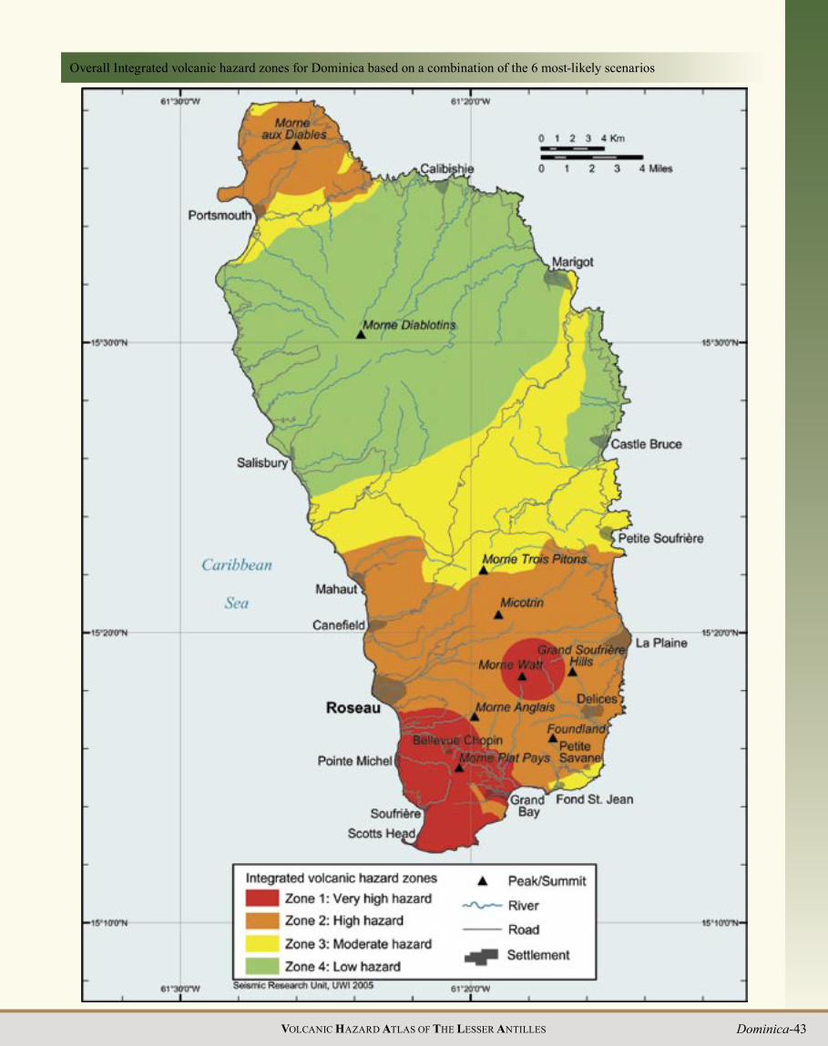
Dominica-43VOLCANIC HAZARD ATLAS OF THE LESSER ANTILLES
Overall Integrated volcanic hazard zones for Dominica based on a combination of the 6 most-likely scenarios

44 VOLCANIC HAZARD ATLAS OF THE LESSER ANTILLES
BibliographyAndreieff P, Bellon H, Westercamp D (1976) Chronometrie et stratigraphie compare des edifices volcaniques et formations sedimentaires de la Martinique (Antilles Français). Transactions VIIth Caribbean Geological Conference (Guadeloupe 1974), pp 345-356
Arculus RJ, Wills KJA (1980) The petrology of plutonic blocks and inclusions from the Lesser Antilles. J Petrol 21:743-799
Atwood T (1791) History of the Island of Dominica;; Containing a description of its situation, extent, climate, mountains, rivers, natural productions etc. J Johnson, London, pp 1-285
Baker PE, Westercamp D, Bouysse Ph (1990) Geology of the Lesser Antilles (The Northern Volcanic Caribbees). In: Dengo G, Case JE (eds) The Geology of North America H - The Caribbean Region. Geol Soc Am, pp 156-160
Bell H (1946) Glimpses of a Governor’s Life – Dominica. Samson Low, London.
Bellon H, Pelletier B, Westercamp D (1974) Donnes geochronometriques relatives au volcanisme martiniquais. CR Acad Sci Paris 279:457-460
Bellon H (1988) Reconnaissance chronologique des deux premieres phases d’activite volcanique en Dominique (Petites Antilles). CR Acad Sci Paris 306:1487-1492
Bert L (1880) Eruption et chute de poussieres volcaniques, le 4 janvier 1880, a la Dominique (Antilles anglaises). CR Acad Sci Paris 90:622-624
Briden JC, Rex DC, Faller AM, Tomblin JF (1979) K-Ar geochronology and paleomagnetism of volcanic rocks in the Lesser Antilles island arc. Philos Trans R Soc London, series A(291):485-528
Brown GM, Holland JG, Sigurdsson H, Tomblin JF, Arculus RJ (1977) Geochemistry of the Lesser Antilles volcanic island arc. Geochim Cosmochim Acta 41:785-801
Brown LK (2002) Gas Geochemistry of the Volcanic Hydrothermal Systems of Dominica and St. Lucia, Lesser Antilles: Implications for Volcanic Monitoring. Senior Honors Thesis, Department of Earth and Planetary Sciences, University of New Mexico, pp 1-31
Carey SN, Sigurdsson H (1980) The Roseau ash: deep-sea tephra deposits from a major eruption on Dominica, Lesser Antilles arc. J Volcanol Geotherm Res 7:67-86
Cas RAF, Wright JV (1987) Volcanic successions, modern and ancient. Chapman and Hall, pp 1-528
Daubrée M (1880a) Examen d es poussières volcaniques tombées le 4 janvier 1880 à la Dominique et de l’eau qui les accompagnait. CR Acad Sci Paris 90:624-626 (repeated in Bull Soc Geog 20:72-75)
Daubrée M (1880b) Produits solides et liquides qui continuaient à sortir, en avril 1880, d’un cratère de la Dominique (Antilles anglaises). CR Acad Sci Paris 91:949-950
Davidson JP (1984) Petrogenesis of Lesser Antilles island arc magmas: Isotope and geochemical constraints. PhD Thesis,
University of Leeds, pp 1-258
Demange J, Leborne H, Traineau H, Westercamp D (1985) Histoire volcano-structurale de la Region sud de la Dominique. Bureau de Recherches Geologiques et Minieres, Institut Mixte de Recherches Geothermiques, Rapport 85 SGN 068 IRG-GTH, pp 1-114
Deplus C, Le Friant A, Boudon G, Komorowski J-C, Villemant B, Harford C, Ségoufin J, Cheminée J-L (2001) Submarine evidence for large-scale debris avalanches in the Lesser Antilles Arc. Earth Planet Sci Lett 192:145-157
Donnely TW, Rogers JJW, Pushkar P, Armstrong RL (1971) Chemical evolution of the igneous rocks of the eastern West Indies;; an investigation of thorium, uranium and potassium distribution, and lead and strontium isotope ratios. In: Donelly TW (ed) Caribbean geophysical, tectonic and petrologic studies. Geol Soc Am Mem 130:181-224
Drumm WM (1849) Earthquakes in Dominica. The Dominica Colonists, Saturday April 21 1849
Earle KW (1928) Geological notes on the island of Dominica. B.W.I. Geol Mag 65:169-187
Eldridge (1880) Recent volcanic eruption at the Grand Souffriere, in the island of Dominica. Procedings of the Royal Geographical Society 2:363-366
Elliot EC (1938) Boiling Lake - The 1900 Story. In: Broken Atoms
Elliot WR (1893) Letter to Nature, Nature 1224(47) April 13 1893
Endlich FM (1880) The Island of Dominica. The American Naturalist 14(11):761-772
Hawkesworth CJ and Powell M (1980) Magma genesis in the Lesser Antilles island arc. Earth Planet Sci Lett 45:297-308
Hovey EO (1904) Boiling Lake of Dominica. Geol Soc Am Bull 16:570-571
Isaacs MC, Shepherd JB (1986) Internal Report, Seismic Research Unit, St. Augustine, Trinidad
Iundt F (1982) Geochemical study of Dominica island. BRGM report 85SGN102GTH pp 1-36
James A (1988) A Cool Boiling Lake? The New Chronicle (Dominica) June 1988
James A (1997a) Observations made in the Valley of Desolation following a volcanic eruption, July 1997. Unpublished report, Forestry and Wildlife Division, Dominica
James A (1997b) And they came tumbling down......The Mega-Slides of 1995. The New Forester (Dominica) Vol X (1997)
Joseph E, Lindsay J (2002) Sampling of geothermal features in Saint Lucia and Dominica 14th - 20th November 2002. Internal Report, Seismic Research Unit, St. Augustine, Trinidad
Joseph E, Robertson R (2003) Sampling of geothermal features in St. Lucia and Dominica, 3rd - 9th November 2003. Internal Report, Seismic Research Unit, St. Augustine, Trinidad
Komorowski J-C, Hammouya G (1998) Analytical results and

Dominica-45VOLCANIC HAZARD ATLAS OF THE LESSER ANTILLES
report on the current activity of the Soufrière area as of December 8-9 1998. Unpublished report presented to the Government of Dominica
Le Friant A, Boudon G, Komorowski J-C, Deplus C (2002) L’île de la Dominique, á l’origine des avalanches de débris les plus volumineuses de l’arc des Petites Antilles. CR Geosci 334:235-243
Le Friant A, Boudon G, Deplus C, Villemant B (2003a) Large scale flank collapse events during the activity of Montagne Pelée, Martinique, Lesser Antillles. J Geophys Res 108(B1):2055
Le Friant A, Heinrich P, Deplus C, Boudon G (2003b) Numerical simulation of the last flank-collapse event of Montagne Pelée, Martinique, Lesser Antillles. Geophys Res Lett 30(2):1034
Lindsay JM, Stasiuk MV, Shepherd JB (2003) Geological history and potential hazards of the late-Pleistocene to Recent Plat Pays volcanic complex, Dominica, Lesser Antilles. Bull Volcanol 65:201-220
Martin-Kaye PHA (1960) Preliminary notes on the geological map of Dominica. Unpublished progress reports of the Government Geologist 1-12. Geological Survey, Windward Islands
Martin-Kaye PHA (1969) A summary of the geology of the Lesser Antilles. Overseas Geology and Mineral Resources 10(2):172-206
Mattioli GS, Jansma PE, Jaramillo L, Smith A (1995) Sector collapse in island arc volcanoes: a digital topographic and bathymetric investigation of the Qualibou Depression, St. Lucia, Lesser Antilles. Carib J Sci 31(3-4):163-173
Monjaret M-C (1985) Contribution a l’etude de l’arc des Petites Antilles. Le Volcanisme de la Dominique. Donnees chronologiques, mineralogiques et geochimiques. Unpublished Thesis, Universite de Bretagne Occidentale, pp 1-77
Newhall C, Dzurisin D (1988) Historical Unrest at Large Calderas of the World. USGS Bull 1855(2) pp 1-924
Nicholls HAA (1880a) The volcanic eruption in Dominica. Nature 21:372-373
Nicholls HAA (1880b) Visit to the scene of the late volcanic eruption. The Dominican, January 17 1880
Norton G, Harford C, Young S (2001) Volcanic Geology of Montserrat, West Indies. Field Guide
Ober FA (1880) Camps in the Caribbees: The adventures of a Naturalist in the Lesser Antilles. Boston, US: Lee and Shepherd;; Edinburgh: Douglas. (Reviewed in Nature July 8 1880 p 215)
Prestoe (1876) On the discovery of a Boiling Lake in Dominica. Procedings of the Royal Geographical Society 20 (III):230-232
Pushkar P (1968) Strontium Isotope Ratios in Volcanic Rocks of Three Island Arc Areas. J Geophys Res 73:2701-2714
Robertson REA (1992) Volcanic Hazard and Risk Assessment of the Soufrière Volcano, St. Vincent, West Indies. MPhil Thesis, Earth Sciences, The University of Leeds, Leeds
Robertson REA, Mohais R (2004) GPS measurements at Morne aux Diables, Dominica. Internal Report, Seismic Research Unit,
St. Augustine, Trinidad
Robson GR (1964) An earthquake catalogue for the Eastern Caribbean 1530-1960. Bull Seismol Soc Am 54(2):785-832
Robson GR, Barr ICG (1960) Unidentified Earth Tremors in Dominica, West Indies. Nature 188(4747):366
Robson GR, Barr ICG (1967) Report of the investigation into the Dominica tremors of 1959 and 1960. University of the West Indies, Seismic Research Unit Special Publication 9
Robson GR, Tomblin JF (1966) Catalogue of the active volcanoes of the world including solfatara fields, part 20, the West Indies. International Association of Volcanologists, pp 1-56
Robson GR, Willmore PL (1955) Some heat measurements in West Indian Soufrières. Bull Volcanol 17:13-39
Roobol MJ, Smith AL (1976) Mt. Pelée Martinique: a pattern of alternating eruptive styles. Geology 4:521-524
Roobol MJ, Smith AL (2004) Volcanology of Saba and St. Eustatius islands, Northern Lesser Antilles. Memoir Netherlands Royal Academy of Arts and Science
Roobol MJ, Wright JV, Smith AL (1983) Calderas or gravity-slide structures in the Lesser Antilles island arc? J Volcanol Geotherm Res 19:121-134
Roobol MJ, Smith AL, Wright JV (1985) Dispersal and chartacteristics of pyroclastic fall deposits from Mt. Misery volcano, West Indies. Geologische Rundschau 74(2):321-325
Sapper K (1903) Ein Besuch von Dominica. Zentralblatt für Mineralogie, Geologie, Paleontologie 305-314
Seismic Research Unit (2000) Volcano Hazard Report for Southern Dominica: Interpretation of 1998-2000 Earthquakes and Hazard Mapping Results. Unpublished report submitted to the Government of Dominica
Seismic Research Unit (2001) Volcano Hazard Report for Southern Dominica: Update to March 15 2001. Unpublished report submitted to the Government of Dominica
Shepherd JB (1986) Earthquake series in Dominica, March 9-10 1986. Caribbean Disaster Preparedness Newsletter 5:5-6
Shepherd JB, Lynch L, Stasiuk M, Latchman J, Lindsay J, Devine J, Hoblitt C, Miller D (2000) Shallow Magma Intrusion Generates Volcanic Earthquake Swarm Beneath Dominica, West Indies, September 1998 to July 2000. Conference Abstracts, IAVCEI General Assembly, Bali
Shepherd JB, Lindsay JM, Stasiuk M (2003) Volcanic Hazards in Dominica. In: Beyond Walls: Multi-disciplinary Perspectives, Volume II: Dominica. School of Continuing studies, University of the West Indies
Sigurdsson H (1972) Partly-welded pyroclast flow deposits in Dominica, Lesser Antilles. Bull Volcanol 36:148-163
Sigurdsson H, Carey SN (1991) Caribbean Volcanoes: A Field Guide to Martinique, Dominica and St. Vincent. Geological Association of Canada, Toronto 1991 field trip guidebooks, pp 1-101
Smith AL, Roobol MJ, Gunn B (1980) The Lesser Antilles: A

46 VOLCANIC HAZARD ATLAS OF THE LESSER ANTILLES
discussion of Island Arc Volcanism. Bull Volcanol 43:287-302
Smith AL, Roobol MJ (1990) Mt. Pelée, Martinique: A study of an active island arc volcano. Geol Soc Am Mem 175, pp 1-105
Sparks RSJ, Sigurdsson H, Carey SN (1980a) The entrance of pyroclastic flows into the sea, I. Oceanographic and geologic evidence from Dominica, Lesser Antilles. J Volcanol Geotherm Res 7:87-96
Sparks RSJ, Sigurdsson H, Carey SN (1980b) The entrance of pyroclastic flows into the sea, II. Theoretical considerations on subaqueous emplacement and welding. J Volcanol Geotherm Res 7:97-105
Stasiuk MV, Shepherd JB, Latchman J, Lindsay JM (2002) Intrusion-induced caldera fault slip imaged by shallow seismicity on Dominica, West Indies, 1998-2000. Seismol Res Lett 73:242
Tomblin JF (1972) Seismicity and plate tectonics of the eastern Caribbean. Transactions VI Caribbean Geological Conference (Margarita 1971), pp 277-282
Tomblin J, Aspinall W, Almorales HJ, Shepherd JB (1974) Dominica local earthquakes, 1974. Reports 1 – 7, Seismic Research Unit, St. Augustine, Trinidad
van Soest MC, Hilton DR, Kreulen R (1998) Tracing crustal and slab contributions to arc magmatism in the Lesser Antilles island arc using helium and carbon relationships in geothermal fluids. Geochim Cosmochim Acta 62:3323-3335
Wadge G (1985) Morne Patates volcano, Southern Dominica, Lesser Antilles. Geol Mag 122(3):253-260
Wadge G (1989) A preliminary analysis of volcanic hazards in Dominica. Internal report, Seismic Research Unit, St. Augustine, Trinidad
Wadsworth ME (1880) The volcanic dust from Dominica. Nature, July 22 1880, pp 266-267
Watt E (1880) Recent volcanic eruption in Dominica. Nature, May 27 1880, p 77
Westercamp D (1976) Petrology of the Volcanic Rocks of Martinique West Indies. Bull Volcanol 39:173-200
Westercamp D, Andreieff P (1989) Carte Geologique de la Martinique au 1:50,000 et notice explicative;; France, Serv Geologique Nacional, BRGM
Whitham AG (1985) Transport and deposition of pyroclastic materials in subaqueous environments. PhD Thesis, University of Cambridge, pp 1-150
Whitham AG (1989) The behaviour of subaerially produced pyroclastic flows in a subaqueous environment: Evidence from the Roseau eruption, Dominica, West Indies. Mar Geol 86:27-40
Wills K (1974) The Geological History of Southern Dominica and Plutonic Nodules from the Lesser Antilles. PhD Thesis, University of Durham
AcknowledgementsThis chapter represents a culmination of the work carried out in Dominica by the authors over the past several years, much of
which has been facilitated by the Seismic Research Unit of the University of the West Indies (UWI). The authors would like to thank all the staff of the Seismic Research Unit for their help, in particular John Shepherd and Joan Latchman for information on seismicity, Patricia Joseph for geothermal data and field assistance, and Shahiba Ali for preparation of most of the maps. Smith and Roobol were supported and funded by grants by the National Science Foundation of the United States, NASA, the University of Puerto Rico at Mayaguez, and California State University, San Bernardino. Many thanks also to Mr. Dado Quero of the Saudi Geological Survey for many hours of patient work in preparing the Geology Map of Dominica. We are very grateful for the cooperation of the staff of the Guadeloupe Volcano Observatory (IPGP), who regularly exchange data on regional seismicity with the Seismic Research Unit, and who shared information on their physico-chemical sampling of thermal springs in southern Dominica between 1997 and 2000 and provided valuable field assistance in the early stages of the recently established UWI-based geothermal sampling programme. We also thank Tobias Fischer and his students at the University of New Mexico for collaboration on all aspects of the geothermal monitoring programme.
Logistical support and vital local knowledge was provided by Cecil Shillingford of the Dominican Office of Disaster Preparedness, Arlington James, Eric Hypolite and Phillip Matthews of the Dominican Department of Forestry and Lennox Honychurch of the School of Continuing Studies, UWI, Dominica. Additional financial support for various aspects of the work summarised in this chapter was provided by the Government of Dominica, the United Kingdom Department for International Development (DFID) and the United States Agency for International Development, Office of Foreign Disaster Assistance (USAID–OFDA). We would also like to thank Joe Devine, Rick Hoblitt, C. Dan Miller, Glen Mattioli, Pamela Jansma, Jean-Christophe Komorowski, Gilbert Hammouya and the staff of Nature Island Dive, Dominica, who have helped with fieldwork over the years, and numerous students from the University of Puerto Rico at Mayaguez, and California State University at San Bernardino for their help with field and laboratory work. We are grateful to the NOAA ship Ronald H. Brown for carrying out a sea-beam bathymetric survey off the southern and northern coasts of the island. This chapter benefited greatly from reviews by Richard Robertson, Lennox Honychurch and Arlington James.
Photograph CreditsAll photographs taken by the authors, except:
Title page: Richard Robertson;;
Page 9: Jerome David;;
Page 13 (left): Paul Jackson;;
Page 13 (right): Linda Brown;;
Page 16 (upper left): Richard Robertson;;
Page 16 (lower left): Arlington James;;
Page 17 (lower right): Paul Jackson;;
Page 19: Richard Robertson;;
Page 20: Paul Jackson

Dominica-47VOLCANIC HAZARD ATLAS OF THE LESSER ANTILLES
Page 36 (right): Richard Robertson;;
Page 40: Challie Minton;;
Page 41: Paul Jackson;;
Page 42: Linda Brown.

48 VOLCANIC HAZARD ATLAS OF THE LESSER ANTILLES