Embed Size (px)
Citation preview
GreenwichDelaware State Soil
Soil Science Society of America
Photo Soil Monolith: Chip Clark/Smithsonian Institution
IntroductionMany states have designated an official state bird, flower, fish, tree, rock, etc. Similarly, each state has a state soil. A state soil is a soil that has significance or is very important to the state. The Greenwich is the official state soil of Delaware. Let’s explore how Green-wich soil is important to Delaware!
HistoryThe Greenwich soil gets its name from a small historical town on the banks of the Co-hansey River in Cumberland County, New Jersey. The town was laid out in 1684, and is known as “The Tea Burning Town” that burned tea on December 21, 1774. It served as a port for trade in colonial times.
On April 20, 2000, Governor Thomas R. Carper signed House Bill 436, which designated Greenwich loam as Delaware’s official State soil. Students from Fifer Middle School assisted primary sponsor Rep. V. George Carey in convincing the General Assembly to adopt Greenwich loam as the State soil. The students made Greenwich soil mini-mono-liths, which they distributed to legislators in an attempt to illustrate the need for the public to be educated about the importance of soils and soil conservation.
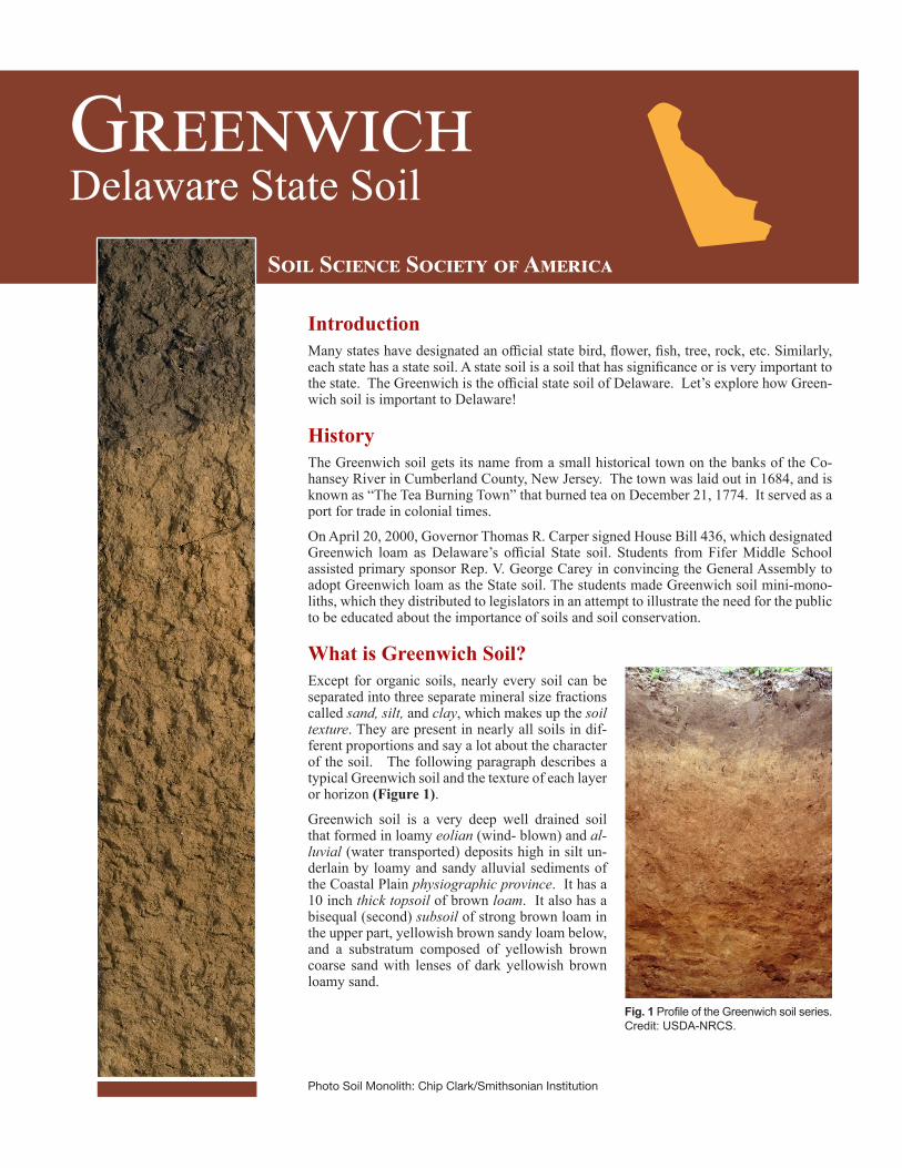
What is Greenwich Soil? Except for organic soils, nearly every soil can be separated into three separate mineral size fractions called sand, silt, and clay, which makes up the soil texture. They are present in nearly all soils in dif-ferent proportions and say a lot about the character of the soil. The following paragraph describes a typical Greenwich soil and the texture of each layer or horizon (Figure 1).
Greenwich soil is a very deep well drained soil that formed in loamy eolian (wind- blown) and al-luvial (water transported) deposits high in silt un-derlain by loamy and sandy alluvial sediments of the Coastal Plain physiographic province. It has a 10 inch thick topsoil of brown loam. It also has a bisequal (second) subsoil of strong brown loam in the upper part, yellowish brown sandy loam below, and a substratum composed of yellowish brown coarse sand with lenses of dark yellowish brown loamy sand.
Fig. 1 Profile of the Greenwich soil series. Credit: USDA-NRCS.
2
Fig. 2. Location of the Greenwich Series in the Delaware extending into the neighboring state of Maryland. Credit: Smithsonian Institution’s Forc-es of change. http://forces.si.edu/soils/interactive/statesoils/index.htm
Fig. 3. Vegetable production on Greenwich loam. Credit: USDA-NRCS
Where to Dig GreenwichYes, you can dig a soil. It is called a soil pit and it shows you the soil profile. The different horizontal layers of the soil are called soil horizons. This does not mean that other types of soil cannot be found there but that the Greenwich is common. These soils oc-cur on the uplands on the coastal plain of Delaware and adjacent States.
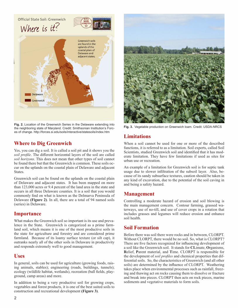
Greenwich soil can be found on the uplands on the coastal plain of Delaware and adjacent states. It has been mapped on more than 123,000 acres or 9.4 percent of the land area in the state and occurs in all three Delaware counties. It is a soil that you would commonly find on what is known as the Delmarva Peninsula of Delaware (Figure 2). In all, there are a total of 94 named soils (series) in Delaware.
ImportanceWhat makes the Greenwich soil so important is its use and preva-lence in the State. Greenwich is categorized as a prime farm-land soil, which means it is one of the most productive soils in the state for agriculture and forestry and are considered prime farmland. Because of its loamy surface texture (or silt cap), it outranks nearly all of the other soils in Delaware in productivity and responds extremely well to good management.
UsesIn general, soils can be used for agriculture (growing foods, rais-ing animals, stables); engineering (roads, buildings, tunnels); ecology (wildlife habitat, wetlands), recreation (ball fields, play-ground, camp areas) and more.
In addition to being a very productive soil for growing crops, vegetables and forest products, it is one of the best suited soils to construction and recreational development (Figure 3).
LimitationsWhen a soil cannot be used for one or more of the described functions, it is referred to as a limitation. Soil experts, called Soil Scientists, studied Greenwich soil and identified that it has mod-erate limitation. They have few limitations if used as sites for urban use or recreation.
An example of a limitation for Greenwich soil is for septic tank usage due to slower infiltration of the subsoil layer. Also, be-cause of its sandy subsurface textures, caution should be taken in any kind of excavation, due to the potential of the soil caving in and being a safety hazard.
ManagementControlling a moderate hazard of erosion and soil blowing is the main management concern. Contour farming, grassed wa-terways, use of no-till, and use of cover crops in a rotation that includes grasses and legumes will reduce erosion and enhance soil health.
Soil FormationBefore there was soil there were rocks and in between, CLORPT. Without CLORPT, there would be no soil. So, what is CLORPT? There are five factors recognized for influencing development of a soil like the Greenwich soil. It stands for CLimate, Organisms, Relief, Parent material, and Time. CLORPT is responsible for the development of soil profiles and chemical properties that dif-ferential soils. So, the characteristics of Greenwich (and all other soils) are determined by the influence of CLORPT. Weathering takes place when environmental processes such as rainfall, freez-ing and thawing act on rocks causing them to dissolve or fracture and break into pieces. CLORPT then acts on rock pieces, marine sediments and vegetative materials to form soils.
3
Climate – Temperature and precipitation influence the rate at which parent materials weather and dead plants and animals de-compose. They affect the chemical, physical and biological rela-tionships in the soil. The Greenwich soil developed under a warm humid climate with mild temperatures and abundant rainfall. The influence of the two resulted in leaching of soluble bases.
Organisms – This refers to plants and animal life. In the soil, plant roots spread through, animals burrow in and bacteria eat plant and animal tissue. These and other soil organisms speed up the breakdown of large soil particles into smaller ones. Plants and animals also influence the formation and differenti-ation of soil horizons. Plants determine the kinds and amounts of organic matter that are added to a soil under normal con-ditions. Animals breakdown complex compounds into small ones and in so doing add organic matter to soil. Greenwich de-veloped under hardwood or pine forests which deposit leaves, twigs, roots and other plant remains on the surface but these readily degrade and leach through the soil.
Relief – Landform position or relief describes the shape of the land (hills and valleys), and the direction it faces makes a dif-ference in how much sunlight the soil gets and how much wa-ter it keeps. Deeper soils form at the bottom of the hill rather than at the top because gravity and water move soil particles downhill. Greenwich soil is well drained because it is formed on the higher position of the landscape.
Parent material (C horizon) – Just like people inherit char-acteristics from their parents, every soil inherited some traits from the material from which it forms. Some parent materi-als are transported and deposited by glaciers, wind, water, or gravity. Greenwich soil formed from loamy eolian (wind-blown) and alluvial (by moving water) deposits high in silt un-derlain by loamy and sandy alluvial sediments of the Coastal Plain physiographic province.
Time – All the factors act together over a very long time to produce soils. As a result, soils vary in age. The length of time that soil material has been exposed to the soil-forming pro-cesses makes older soils different from younger soils. General-ly, older soils have better defined horizons than younger soils. Less time is needed for a soil profile to develop in a humid and warm area with dense vegetative cover where the Greenwich soil is than in a cold dry area with sparse plant cover. More time is required for the formation of a well-defined soil profile in soils with fine textured material than in soils with coarse-textured soil material.
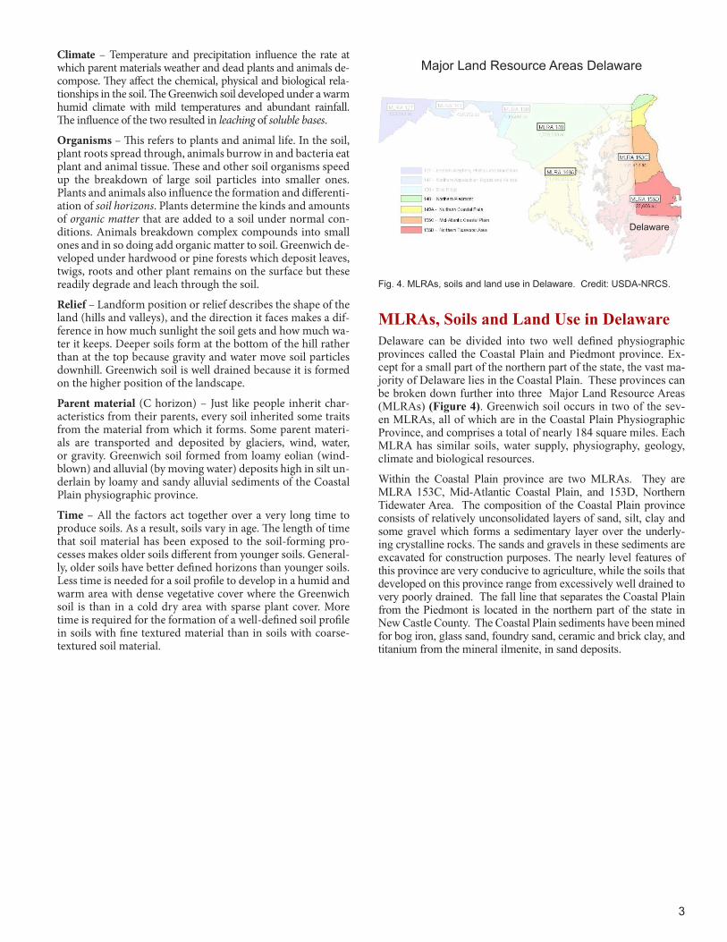
MLRAs, Soils and Land Use in DelawareDelaware can be divided into two well defined physiographic provinces called the Coastal Plain and Piedmont province. Ex-cept for a small part of the northern part of the state, the vast ma-jority of Delaware lies in the Coastal Plain. These provinces can be broken down further into three Major Land Resource Areas (MLRAs) (Figure 4). Greenwich soil occurs in two of the sev-en MLRAs, all of which are in the Coastal Plain Physiographic Province, and comprises a total of nearly 184 square miles. Each MLRA has similar soils, water supply, physiography, geology, climate and biological resources.
Within the Coastal Plain province are two MLRAs. They are MLRA 153C, Mid-Atlantic Coastal Plain, and 153D, Northern Tidewater Area. The composition of the Coastal Plain province consists of relatively unconsolidated layers of sand, silt, clay and some gravel which forms a sedimentary layer over the underly-ing crystalline rocks. The sands and gravels in these sediments are excavated for construction purposes. The nearly level features of this province are very conducive to agriculture, while the soils that developed on this province range from excessively well drained to very poorly drained. The fall line that separates the Coastal Plain from the Piedmont is located in the northern part of the state in New Castle County. The Coastal Plain sediments have been mined for bog iron, glass sand, foundry sand, ceramic and brick clay, and titanium from the mineral ilmenite, in sand deposits.
Fig. 4. MLRAs, soils and land use in Delaware. Credit: USDA-NRCS.
Major Land Resource Areas Delaware
Delaware

Additional ResourcesSoil! Get the Inside Scoop. David Lindbo and others. Soil Science Society of America, Madison, WI.Know Soil, Know Life. David L. Lindbo, Deb A. Kozlowski, and Clay Rob-inson, editors. Soil Science Society of America, Madison, WI.
Web Resources Soils for Teachers—www.soils4teachers.orgSoils for Kids—http://www.soils4kids.org/Have Questions? Ask a Soil Scientist—https://www.soils.org/askSoil Science Society of America—https://www.soils.org/Natural Resources Conservation Service, Delaware Homepage—www.nrcs.usda.gov/wps/portal/nrcs/site/de/home/Natural Resources Conservation Service, Soils—www.nrcs.usda.gov/wps/portal/nrcs/main/national/soils/Natural Resources Conservation Service, K through 6 Educational Re-sources—www.nrcs.usda.gov/wps/portal/nrcs/main/soils/edu/kthru6/National Association of Conservation Districts—Delaware. www.nacdnet.org/northeast-region/
ReferencesDelaware State Soil – Greenwich. www.nrcs.usda.gov/wps/portal/nrcs/detail/soils/edu/?cid=stelprdb1236841Soil Survey of New Castle County, Delaware. www.udel.edu/FREC/spatlab/oldpix/nrcssoilde/Archives/NewCastleConvert/index.htmWeb Soil Survey. http://websoilsurvey.nrcs.usda.gov
Author: William Dean Cowherd, USDA-NRCS - Assistant State Soil Scientist, Maryland
GlossaryAlluvial: Pertaining to processes or materials associated with trans-portation or deposition by running water.Clay: A soil particle that is less than 0.002 mm in diameter. Clay par-ticles are so fine they have more surface area for reaction. They hold a lot of nutrients and water in the soil. A clay soil is a soil that has 40% or more clay, less than 45% sand and less than 40% or less silt. Coarse sand: Soil material that contains 25 % or more very coarse sand (2-1 mm diameter) and coarse sand (1.0-0.5 mm diameter), and is less than 50% of any other one grade of sand.Eolian: Pertaining to earth material transported and deposited by the wind including dune sands, sand sheets, loess, and parna.Fluviomarine deposits: Of or pertaining to material deposited by oceans and reworked and deposited by streams after exposure.Horizon: see Soil Horizon Leaching: The removal of soluble material from soil or other material by percolating water. Loam: Soil material that contains 7-27% clay, 28-50% silt, and less than 52% sand.Loamy sand: Soil material that is a mixture of between 70-90% sand, up to 30% silt, and less than 15% clay. It has more sand than sandy loam. Major land resource areas (MLRAs): Geographically associated land resource units. Identification of these large areas is important in statewide agricultural planning and has value in interstate, regional, and national planning. Each MLRA has similar soils, water use, physi-ography, geology, climate and biological resources. They influence the type of land cover that can exist and the range of land use prac-tices that are possible. Organic matter: Material derived from the decay of plants and ani-mals. It always contains compounds of carbon and hydrogen. Physiographic province: Broad-scale subdivisions based on terrain texture, rock type, and geologic structure and history. Sand: A soil particle between 0.05 and 2.0 mm in diameter. Soil mate-rial that is 85% or more sand and the percent silt plus 1.5 times the percent clay is less than 15%. Sandy Loam: Soil material that contains 43% sand, 0-50% silt and less than 7% clay. Silt: A soil particle between 0.002 and 0.05 mm diameter. As a soil textural class, soil that is 80% or more silt, and less than 12% clay. Soil Horizon: A layer of soil with properties that differ from the layers above or below it. Soil Management: The sum total of how we prepare and nurture soil, select type of crops suitable for a type of soil, tend the crop and the soil together, select type of fertilizer and other materials added to the soil so as to maintain productivity and preserve the soil. Soil Profile: The sequence of natural layers, or horizons, in a soil. It extends from the surface downward to unconsolidated material. Most soils have three major horizons, called the surface horizon, the sub-soil, and the substratum. Soluble bases: Elements (calcium, magnesium, sodium and potas-sium) that are present in soil as ions and form what is called cation exchange capacity. The amount in the soil can be reduced through leaching. Subsoil (B horizon): The soil horizon rich in minerals that eluviated, or leached down, from the horizons above it. Not present in all soils. Topography: The shape of the land surface. (Relief: refers to differ-ences in elevation of different points in a region.) Topsoil (A horizon): The horizon that formed at the land surface made up mostly of weathered minerals from parent material with usu-ally the highest percent of organic matter. Very Coarse Sand: A soil particle between 2.0 and 1.0 mm in diam-eter. The largest particle of the five fractions of sand.
5585 Guilford RoadMadison WI 53711-5801Tel. 608-273-8080 • Fax 608-273-2021www.soils.org • [email protected]
This state soil booklet was developed under the auspices of the Soil Science Society of America’s K-12 Committee—their dedication to developing outreach materials for the K-12 audience makes this material possible.


![Block Caving [Recuperado]](https://img.dokumen.tips/doc/110x75/55cf8c685503462b138c1152/block-caving-recuperado.jpg)