Embed Size (px)
Citation preview
Prepared for:
Greater Nottingham New Growth Point Partnership
Greater Nottingham
Scoping Water Cycle Study
May 2009

Greater Nottingham New Growth Point Partnership
Greater Nottingham – Scoping Water Cycle Study
Scott Wilson Mansfield i-Centre
Oakham Business Park Hamilton Way
Mansfield NG18 5BR
Tel: 01623 600 660 Fax: 01623 600 661
www.scottwilson.com
This document has been prepared in accordance with the scope of Scott Wilson's appointment with its client and is subject to the terms of that appointment. It is addressed to and for the sole and confidential use and reliance of Scott Wilson's client. Scott Wilson accepts no liability for any use of this document other than by its client and only for the purposes for which it was prepared and provided. No person other than the client may copy (in whole or in part) use or rely on the contents of this document, without the prior written permission of the Company Secretary of Scott Wilson Ltd. Any advice, opinions, or recommendations within this document should be read and relied upon only in the context of the document as a whole. The contents of this document do not provide legal or tax advice or opinion. © Scott Wilson Ltd 2009
Revision Schedule Greater Nottingham - Scoping Water Cycle Study May 2009
Rev Date Details Prepared by Reviewed by Approved by
01 April 2009 Draft Gemma Costin Assistant Flood Risk Specialist
Andrew Woodliffe Senior Flood Risk Specialist
Jon Robinson Associate Director
02 April 2009 Final Gemma Costin Assistant Flood Risk Specialist
Andrew Woodliffe Senior Flood Risk Specialist
Jon Robinson Associate Director
03 May 2009 Final v2 Fay Tivey Assistant Flood Risk Specialist
Andrew Woodliffe Senior Flood Risk Specialist
Jon Robinson Associate Director
Greater Nottingham New Growth Point Partnership
Greater Nottingham – Scoping Water Cycle Study
Scoping Report May 2009
Table of Contents
Acronyms..................................................................................................... 1
1 Executive Summary .......................................................................... 5
2 Introduction ....................................................................................... 7
2.1 Terms of Reference ........................................................................................................7
2.2 Project Steering Group Stakeholders ..............................................................................7
2.3 Background Overview .....................................................................................................7
2.4 Aims and Objectives .......................................................................................................8
3 Greater Nottingham Water Cycle Study .......................................... 10
3.1 The Water Cycle ...........................................................................................................10
3.2 Implications for Development ........................................................................................11
3.3 Stages of a Water Cycle Study......................................................................................11
3.4 Integration with the Planning System ............................................................................14
3.5 Data Availability.............................................................................................................14
4 Development in Greater Nottingham............................................... 15
4.1 Greater Nottingham.......................................................................................................15
4.2 Proposals ......................................................................................................................15
4.3 National, Regional and Local Drivers & Policies ............................................................16
5 Water Cycle Environment and Infrastructure................................... 24
5.1 Introduction ...................................................................................................................24
5.2 Data Sources ................................................................................................................24
5.3 Water Resources and Supply........................................................................................24
5.4 Catchment Abstraction Management Strategies............................................................30
5.5 Severn Trent Water - Water Supply Strategy ................................................................32
5.6 Flood Risk .....................................................................................................................36
5.7 Wastewater Treatment and Collection...........................................................................41
5.8 Water Quality ................................................................................................................43
5.9 Ecology and Biodiversity ...............................................................................................52
6 Conclusions and Progression of WCS ............................................ 57
6.1 Key Findings .................................................................................................................57
6.2 Outline WCS .................................................................................................................57
6.3 Project Steering Group Stakeholders ............................................................................60
Appendix A - Data Catalogue Appendix B - Maps

Greater Nottingham New Growth Point Partnership
Greater Nottingham – Scoping Water Cycle Study
Scoping Report May 2009 1
Acronyms
Abbreviation Description
AAP Area Action Plan
AA Appropriate Assessment
ADC Ashfield District Council
AMP Asset Management Plan
BAP Biodiversity Action Plan
BAT Best Available Technology
BATNEEC Best Available Technology Not Entailing Excessive Cost
BBC Broxtowe Borough Council
BOD Biochemical Oxygen Demand
BW British Waterways
CAMS Catchment Abstraction Management Strategy
CFMP Catchment Flood Management Plan
CSH Code for Sustainable Homes
CSO Combined Sewer Overflow
CLG Communities and Local Government
DCC Derbyshire County Council
DEFRA Department for Environment, Food and Rural Affairs
DO Dissolved Oxygen/Deployable Output
DPD Development Plan Document
DWF Dry Weather Flow
DWI Drinking Water Inspectorate
EA Environment Agency
EBC Erewash Borough Council
EMRA East Midland Regional Assembly
EU European Union
FAS Flood Alleviation Scheme

Greater Nottingham New Growth Point Partnership
Greater Nottingham – Scoping Water Cycle Study
Scoping Report May 2009 2
Abbreviation Description
FtFT Flow to Full Treatment
GBC Gedling Borough Council
GI Green Infrastructure
GNNGPP Greater Nottingham New Growth Point Programme
GQA General Quality Assessment
GWV Groundwater Vulnerability
HA Highways Agency
HMA Housing Market Area
HRA Habitats Regulation Assessment
IDB Internal Drainage Board
JPAB Joint Planning Advisory Board
l/c.d Litres per capita per day (water consumption measurement)
LDF Local Development Framework
LDS Local Development Scheme
LiDAR Light Detection and Ranging
LNR Local Nature Reserve
LPA Local Planning Authority
MBR Membrane Bioreactor
N Nitrogen
NCIC Nottingham City Council
NCOC Nottingham County Council
NE Natural England
NGP New Growth Point
NE Natural England
NVZ Nitrate Vulnerable Zone
OFWAT The Office of Water Services
P Phosphorous
PE Population Equivalent
POM Programme of Measure

Greater Nottingham New Growth Point Partnership
Greater Nottingham – Scoping Water Cycle Study
Scoping Report May 2009 3
Abbreviation Description
PPS Planning Policy Statement
PR Price Review
PUA Principal Urban Area
RBC Rushcliffe Borough Council
RBMP River Basin Management Plan
RBD River Basin District
RPB Regional Planning Body
RSS Regional Spatial Strategy
RQO River Quality Objectives
SA Sustainability Appraisal
SAC Special Area for Conservation
SEA Strategic Environmental Assessment
SfG Strategy for Growth
SFRA Strategic Flood Risk Assessment
SIMCAT EA mathematical River Water Quality Model
SPA Special Protection Area
SPD Supplementary Planning Documents
SPZ Source Protection Zone
SRP Soluble Reactive Phosphorus
SSSI Site of Special Scientific Interest
ST Severn Trent Water
SW Scott Wilson
SWMP Surface Water Management Plan
SuDS Sustainable Drainage Systems
TSFR Treated Sewage Flow Recorder (flow meter)
TSS Total Suspended Solids (in waste water)
UWWTD Urban Wastewater Treatment Directive
WCS Water Cycle Study
WFD Water Framework Directive

Greater Nottingham New Growth Point Partnership
Greater Nottingham – Scoping Water Cycle Study
Scoping Report May 2009 4
Abbreviation Description
WRMP Water Resources Management Plan
WRPZ Water Resources Planning Zone
WRZ Water Resources Zone
WTW Water Treatment Works
WSI Water Services Infrastructure
WwTW Waste Water Treatment Works

Greater Nottingham New Growth Point Partnership
Greater Nottingham – Scoping Water Cycle Study
Scoping Report May 2009 5
1 Executive Summary
1.1 In 2005 Greater Nottingham was designated as a New Growth Point (along with the Leicester
and Derby Housing Market Areas) by the Government. The Local Planning Authorities in Greater
Nottingham are working together to deliver Growth Point priorities and to align their Core
Strategies as part of their Local Development Frameworks (LDFs).
1.2 The East Midlands Regional Plan (RSS8) sets out targets to guide the scale of growth in Greater
Nottingham, which ultimately must be reflected within each district’s Local Development
Framework. A number of technical studies have been commissioned by the Growth Point
partners to provide an evidence base to inform the preparation of their Local Development
Frameworks and this Scoping Water Cycle Study (WCS) forms part of this evidence. The WCS
will also inform Development Plan Documents to assist in ensuring the delivery of water cycle
management requirements at a local level. It is important to note that this makes no decisions on
the location for growth.
1.3 The Scoping WCS has been undertaken to inform and facilitate the undertaking of an Outline
WCS and a Detailed WCS (where required), building upon previous and on-going work
undertaken in the area, and providing a holistic and wider evidence-based approach to feed into
the LDF.
1.4 The Scoping WCS has undertaken an initial review of available data and provided an overview of
issues relating to clean water and wastewater infrastructure capacity, water resource availability,
water quality, flood risk (and drainage) and potential ecological impacts of development.
1.5 Discussions with the respective LPAs, the Environment Agency (EA), Severn Trent Water (ST)
and Natural England (NE) were also undertaken to identify key issues and constraints in relation
to the proposed development within Greater Nottingham and Ashfield.
1.6 The key findings from the Scoping WCS are listed below:
• The EAs view is that the study area lies within an area of ‘moderate water stress’1,
• An initial statement from ST states there are no expected treatment capacity issues in
terms of treating wastewater generated from the proposed development within Greater
Nottingham, however this position should be reviewed as part of the Outline WCS. Early
engagement with ST as part of the Outline WCS should ensure that critical data relating to
the wastewater network is obtained,
• The management of surface water has the potential to act as a constraint to development
within Greater Nottingham and Ashfield due to space requirements and the need to reduce
runoff rates and volumes to limit discharges,
• Water quality impacts in main rivers and small watercourses, drains and ditches in the
study area should also be managed,
• Reduced water quality, due to increased volumes of treated sewage effluent being
discharged into the watercourses and poorly managed urban runoff from new development
areas, could impact upon European, National and Locally important ecological sites,
particularly those downstream of development sites.
1 Environment Agency; 2007; Areas of Water Stress, Final Classification; Environment Agency

Greater Nottingham New Growth Point Partnership
Greater Nottingham – Scoping Water Cycle Study
Scoping Report May 2009 6
1.7 As initially set out in the Scoping Study Brief, the Stage 2 – Outline Study should:
• Identify environmental risks,
• Identify if environmental resources can cope with further development,
• Demonstrate that in principle there is sufficient forecast environmental capacity,
• Demonstrate that in principle infrastructure requirements are feasible (technically,
financially and legally) for the timescale of planned development,
• Provide evidence on thresholds for certain infrastructure provision.
1.8 In addition to the brief and EA guidance, the key recommendations of this scoping study are that
an Outline WCS for Greater Nottingham includes the following:
• For completeness, and to ensure a meaningful geographic scope for the study, the study
area should cover the whole of the Greater Nottingham area, which includes Hucknall, but
also extend to cover the whole of Ashfield District Council’s Administrative Area,
• A detailed assessment of the water resource availability and demand up to 2026,
• An assessment of the capacity of the wastewater and clean water networks, both currently
and factoring in the proposed development, to identify the key constraints and required
phasing of development to ensure that development does not outstrip capacity,
• An assessment of the flood risk posed to and by proposed development and suitable
mitigation options, with particular regards to surface water and sewer flooding. An
assessment regarding the potential need for a Surface Water Management Plan (SWMP)
should also be made. As identified in the SFRAs, this is particularly important for
development in Hucknall and Gedling to avoid increasing flood risk to the City of
Nottingham through increasing flows in the River Leen and Day Brook, and in Hucknall to
avoid increasing flows (and associated flood risk) to Baker Lane Brook. In addition, the
Outline study should take account of the Left Bank Flood Alleviation Scheme on the River
Trent and any detailed flood risk studies in the area,
• An assessment of the likely surface water storage and potential sustainable drainage
system (SuDS) requirements for proposed development,
• An environmental assessment of the impact of proposed development upon watercourses
and ecologically important sites. This includes the impacts on and requirements for
increased discharges at WwTWs,
• An assessment of the effects of climate change on the water cycle within the Greater
Nottingham study area,
• An assessment of the phasing of proposed development sites and key constraints, with
reference to the above factors.

Greater Nottingham New Growth Point Partnership
Greater Nottingham – Scoping Water Cycle Study
Scoping Report May 2009 7
2 Introduction
2.1 Terms of Reference
2.1.1 Scott Wilson Ltd (SW) were commissioned by the Greater Nottingham Growth Point partners to
undertake a Scoping Water Cycle Study (WCS) for the Greater Nottingham Area. The extent of
this area is indicated on Figure B-1 (Appendix B).
2.1.2 This area covers the whole administrative areas of Broxtowe Borough Council, Gedling
Borough Council, Erewash Borough Council, Nottingham City Council and Rushcliffe Borough
Council but only the Hucknall wards of Ashfield District Council. However for reasons of
completeness and to achieve a meaningful geography from a water management point of view,
the whole of Ashfield District Council’s administrative area is included within the scope of the
study.
2.1.3 WCSs are required to ensure that proposed growth does not adversely impact on the existing
water cycle environment and that new Water Services Infrastructure (WSI) can be planned for
and provided alongside new development in a sustainable and cost effective manner.
2.1.4 The six LPAs included in the GNNGPP require a WCS to support the evidence base for their
Core Strategy and Site Allocation Plan (Development Plan Documents (DPDs)). In so doing, it
will also integrate with other related studies and reports, to jointly inform the overall Local
Development Framework (LDF). It will also provide sufficient information for Severn Trent
Water (ST) to allow for any additional water cycle infrastructure to be included in their draft
Business Plan as part of the 2009 Price Review Process (PR09).
2.2 Project Steering Group Stakeholders
2.2.1 The WCS Steering Group established during the Scoping phase of the WCS should be
continued and widened as part of the outline phase. The Steering Group will oversee the
management and direction of the project. In addition to the GNNGPP Authorities, the Steering
Group for this commission comprises:
• The Environment Agency – as the statutory planning and flood risk consultee as well as
regulator for water quality,
• Severn Trent Water – as provider of wastewater infrastructure and water supply
infrastructure to study area,
2.3 Background Overview
2.3.1 The Growth Points initiative was announced in 2005 and was designed to provide support to
local communities who wish to pursue large scale and sustainable growth, including new
housing, through a partnership with the Government. The Government invited LPAs to submit
strategic growth proposals which were sustainable, acceptable environmentally and realistic in
terms of infrastructure to be assessed by Government and its agencies.
2.3.2 Whilst not being a statutory designation the growth point status is based upon partnership
working that incorporates four key principles:
• Early delivery of housing as part of the growth plans,

Greater Nottingham New Growth Point Partnership
Greater Nottingham – Scoping Water Cycle Study
Scoping Report May 2009 8
• Supporting local partners to achieve sustainable growth,
• Working with local partners to ensure that infrastructure and service provision keep pace
with growth,
• Ensuring effective delivery.
2.3.3 The extent of the study area is Greater Nottingham (see Figure B-1). This area covers the
whole administrative areas of Broxtowe Borough Council, Gedling Borough Council, Erewash
Borough Council, Nottingham City Council and Rushcliffe Borough Council but only the
Hucknall wards of Ashfield District Council. However for reasons of completeness and to
achieve a meaningful geography from a water management point of view the whole of Ashfield
District Council’s Administrative area is included within the scope of the study.
2.3.4 The Greater Nottingham Joint Planning Advisory Board (JPAB) oversees both a coordinated
approach in planning making across Greater Nottingham and the Nottingham Growth Point
Programme of Delivery. As part of this unified approach, the Nottingham Core HMA LPAs and
Ashfield have established a commitment to working in partnership in producing their LDFs and
in particular have aligned the timetable in the respective production of their core strategies. As
part of this process, the authorities are currently revising their respective Local Development
Schemes (LDS), while co-ordinated Core Strategy Issues and Options consultations are
anticipated in June 2009.
2.4 Aims and Objectives
2.4.1 The key objectives of this first stage of the Greater Nottingham WCS, the Scoping Report, have
been identified as follows:
• Identify and define the optimum study area of the WCS through consultation with
infrastructure providers, taking into account likely locations for new developments and
relevant water catchments. Consideration will be given to the neighbouring Derby Housing
Market WCS to address any overlap between the areas,
• Identify the aims and objectives of the Phase 2 (Outline) WCS and which plans and
strategies should be used to inform it, should the Scoping WCS recommend further stages
of the WCS process,
• Confirm and bring together the relevant stakeholders and their responsibilities for the
various elements of the water cycle,
• Identify what studies have already been undertaken, the current data availability and
necessary requirements,
• Discuss the likely development scenarios and availability of planning data with relevant key
stakeholders,
• Identify the availability of higher level analyses already undertaken by the Environment
Agency (EA) and ST on the capacity of the environment and major infrastructure to define
the key issues to be addressed,
• Identify the natural and artificial water infrastructure constraints on the scale of proposed
development, and the critical issues to be addressed,
• Assess the flexibility of location within development plans,

Greater Nottingham New Growth Point Partnership
Greater Nottingham – Scoping Water Cycle Study
Scoping Report May 2009 9
• Confirm whether a full WCS is required/considered necessary to inform strategic planning
decisions,
• Confirm whether there are any additional requirements for the Outline WCS and potentially
the Detailed WCS,
• Agree the project scope and project plan for any further work determined to be required,
• Identify any likely additional disbursement costs,
• Identify any potential sources of funding for future work.
2.4.2 The impacts of flood risk within the study area have been assessed in the Greater Nottingham
Level 2 Strategic Flood Risk Assessment (SFRA) (Black & Veatch, June 2008) and the River
Leen and Day Brook Level 2 SFRA (Black & Veatch, September 2008); and Ashfield Level 1
SFRA (February 2009). Detailed findings of these studies should be reviewed during the next
stage of the WCS.
Greater Nottingham New Growth Point Partnership
Greater Nottingham – Scoping Water Cycle Study
Scoping Report May 2009
10
3 Greater Nottingham Water Cycle Study
3.1 The Water Cycle
3.1.1 In its simplest form, the water cycle can be defined as ‘the process by which water is continually
recycling between the earth’s surface and the atmosphere’. Without considering human
influences, it is simply the process by which rain falls, and either flows over the earth’s surface
or is stored (as groundwater, ice or lakes) and is then returned to the atmosphere (via
evaporation from the sea, the soil, surface water or animal and plant life) ready for the whole
process to repeat again.
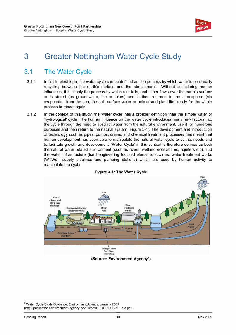
3.1.2 In the context of this study, the ‘water cycle’ has a broader definition than the simple water or
‘hydrological‘ cycle. The human influence on the water cycle introduces many new factors into
the cycle through the need to abstract water from the natural environment, use it for numerous
purposes and then return to the natural system (Figure 3-1). The development and introduction
of technology such as pipes, pumps, drains, and chemical treatment processes has meant that
human development has been able to manipulate the natural water cycle to suit its needs and
to facilitate growth and development. ‘Water Cycle’ in this context is therefore defined as both
the natural water related environment (such as rivers, wetland ecosystems, aquifers etc), and
the water infrastructure (hard engineering focused elements such as: water treatment works
(WTWs), supply pipelines and pumping stations) which are used by human activity to
manipulate the cycle.
Figure 3-1: The Water Cycle
(Source: Environment Agency2)
2 Water Cycle Study Guidance, Environment Agency, January 2009 (http://publications.environment-agency.gov.uk/pdf/GEHO0109BPFF-e-e.pdf)
Greater Nottingham New Growth Point Partnership
Greater Nottingham – Scoping Water Cycle Study
Scoping Report May 2009
11
3.2 Implications for Development
3.2.1 In directly manipulating elements of the water cycle, humankind affects many changes to the
natural water cycle which can often be negative. To facilitate growth and development, there is
a requirement for clean water supply which is taken from natural sources (often depleting
groundwater stores or surface systems); the treatment of waste water which has to be returned
to the system (affecting the quality of receiving waters); and the alteration and management of
natural surface water flow paths which has implications for flood risk. These impacts can
indirectly affect ecology which can be dependent on the natural features of a water cycle for
example wading birds and wetland habitat, or brown trout breeding in a chalk stream which
derives much of its flow from groundwater sources.
3.2.2 In many parts of the UK, some elements of the natural water cycle are considered to be at, or
close to their limit in terms of how much more they can be manipulated. Further development
will lead to an increase in demand for water supply and a commensurate increase in the
requirement for waste water treatment; in addition, flood risk may increase if development is not
planned for in a strategic manner. The sustainability of the natural elements of the water cycle
is therefore at risk.
3.2.3 A WCS is an ideal solution to addressing this problem. It will ensure that the sustainability of
new development is considered with respect to the water cycle, and that new water
infrastructure introduced to facilitate growth is planned for in a strategic manner; in so doing, the
WCS can ensure that provision of water infrastructure is sufficient such that it maintains a
sustainable level of manipulation of the natural water cycle.
3.3 Stages of a Water Cycle Study
3.3.1 Overview
3.3.1.1 Current EA guidance on WCS’s2 suggests that they should generally be undertaken in three
stages, dependent on the status of the various LDDs, as part of the wider LDF, being prepared
by LPAs for submission. To coincide with the individual LPAs’ timescales for responses and
submissions the WCS is being undertaken in three distinct stages: scoping, outline and detail (if
required).
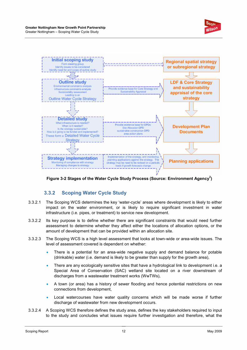
3.3.1.2 Figure 3-2 illustrates the three stages of the WCS and how they inform planning decisions and
documents. This study undertakes the first initial scoping stage.
Greater Nottingham New Growth Point Partnership
Greater Nottingham – Scoping Water Cycle Study
Scoping Report May 2009
12
Figure 3-2 Stages of the Water Cycle Study Process (Source: Environment Agency
2)
3.3.2 Scoping Water Cycle Study
3.3.2.1 The Scoping WCS determines the key ‘water-cycle’ areas where development is likely to either
impact on the water environment, or is likely to require significant investment in water
infrastructure (i.e. pipes, or treatment) to service new development.
3.3.2.2 Its key purpose is to define whether there are significant constraints that would need further
assessment to determine whether they affect either the locations of allocation options, or the
amount of development that can be provided within an allocation site.
3.3.2.3 The Scoping WCS is a high level assessment that looks at town-wide or area-wide issues. The
level of assessment covered is dependent on whether:
• There is a potential for an area-wide negative supply and demand balance for potable
(drinkable) water (i.e. demand is likely to be greater than supply for the growth area),
• There are any ecologically sensitive sites that have a hydrological link to development i.e. a
Special Area of Conservation (SAC) wetland site located on a river downstream of
discharges from a wastewater treatment works (WwTWs),
• A town (or area) has a history of sewer flooding and hence potential restrictions on new
connections from development,
• Local watercourses have water quality concerns which will be made worse if further
discharge of wastewater from new development occurs.
3.3.2.4 A Scoping WCS therefore defines the study area, defines the key stakeholders required to input
to the study and concludes what issues require further investigation and therefore, what the

Greater Nottingham New Growth Point Partnership
Greater Nottingham – Scoping Water Cycle Study
Scoping Report May 2009
13
scope of the Outline WCS should be. A Scoping WCS includes preliminary data identification,
collection (where appropriate) and strategy inception.
3.3.3 Outline and Detailed Water Cycle Studies
Outline Water Cycle Study
3.3.3.1 The Outline WCS considers all of the ways in which new development will impact on the water
environment or water infrastructure specific to where growth is most likely to be targeted. It is
usually undertaken during consideration of allocating sites such that it can inform the decision
process in terms of where development will be targeted for each authority by identifying the
infrastructure required to meet the demands for growth.
3.3.3.2 The key aim of an Outline WCS is to provide LPAs with the evidence base which ensures that
water issues have been taken into account when deciding the location and intensity of
development within an authority’s planning area as part of the development of the Core
Strategy. It also aids in setting core policies related to water as part of the Development
Control Policies Development Plan Documents (DPD).
3.3.3.3 It also provides water companies with an evidence base for its business plans, which determine
how much they can charge customers to invest in upgrades and the provision of new
infrastructure required to service proposed development. Methods for developer contributions to
the capital costs of the proposed schemes should therefore be identified.
3.3.3.4 The individual LPAs are at an early stage with the production of their Core Strategies with
Issues and Options consultation planned for June 2009. If required, the Outline WCS will follow
immediately upon completion of this Scoping WCS to ensure that water cycle issues are
adequately addressed for the favoured development options.
3.3.3.5 It could be that the Outline WCS identifies that water cycle issues are not significant, and that
new development can be implemented without significant new investment. If this is the case, a
Detailed WCS may not be required. However, if new infrastructure is required, or an impact on
the water environment cannot be ruled out as significant, a Detailed WCS will need to be
undertaken for site-specific allocations, for individual authorities or for the study area as a
whole.
Detailed Water Cycle Study
3.3.3.6 Once the principles outlined in Outline WCS have been agreed by the stakeholders and
identified as potential options, the Detailed WCS would then build upon this. Detailed WCSs
can vary significantly in scope and remit. However, it is the key purpose of a Detailed WCS to
define what specific infrastructure and mitigation is required to facilitate development, once the
decisions have been made on the location of allocations and the likely intensity and type of
development within them. It would entail the development of a strategy and provide supporting
evidence for the proposed development works and confirm the capital and operating costs
associated with these.
3.3.3.7 Dependent on the findings of the Outline WCS, there could be the potential requirement to
undertake detailed and complex studies in order to define exactly what infrastructure or
mitigation is required. Furthermore, it would provide an in-depth assessment of developer
contributions.
3.3.3.8 The Detailed WCS should be undertaken in conjunction with the development of DPDs such as
Area Action Plans (AAPs) and should provide the evidence base to site-specific policies in
SPDs.

Greater Nottingham New Growth Point Partnership
Greater Nottingham – Scoping Water Cycle Study
Scoping Report May 2009
14
3.4 Integration with the Planning System
3.4.1 As part of the LDF process, LPAs are required to produce evidence based studies which
support the selection processes used in deciding on final growth targets and areas to be
promoted for growth. The WCS is one such example of an evidence-based study which
specifically addresses the impact of proposed growth on the water cycle.
3.4.2 As part of GNNGPPs overall strategy to meet future growth targets set out in the RSS in a
sustainable way, the WCS is one of a number of strategic studies and plans which will form part
of the evidence base supporting the production of the individual LPA LDFs. Specifically, the
WCS will form an important basis of each of the individual LPA Core Strategy making up part of
their LDF evidence base, as well as providing input to the development of SPDs to assist in
ensuring the delivery of water cycle management requirements at the local planning application
level. There is a strong inter-relationship between the WCS and other components of the LDF
evidence base.
3.4.3 It is important that the findings of the WCS inform and vice versa the findings of other studies
prepared by the LPA and other stakeholders. The studies that are particularly relevant are:
• Draft Water Resource Management Plan (WRMP) (Severn Trent Water),
• Lower Trent and Erewash Catchment Abstraction Management Strategy (CAMS)
(Environment Agency),
• Idle and Torne Catchment Abstraction Management Strategy (CAMS) (Environment
Agency)
• Greater Nottingham Strategic Flood Risk Assessment (Broxtowe BC, Erewash BC, Gedling
BC, Nottingham CC, Rushcliffe BC, Environment Agency),
• River Leen and Day Brook Strategic Flood Risk Assessment (Nottingham City Council,
Environment Agency, Nottingham Regeneration Limited),
• Ashfield Strategic Flood Risk Assessment (Ashfield District Council),
• River Trent Catchment Flood Management Plan (CFMP) (Environment Agency),
Additionally, the findings of the WCS can be used by the individual LPAs in the preparation and
revision to their Spatial Plans, Masterplans and design briefs for their administrative areas.
3.5 Data Availability
3.5.1 The undertaking of a WCS requires a large amount of data collection, much of which is reliant
on the willingness of third parties to supply in order to allow the study to be progressed. In some
cases, the availability of data with respect to water cycle infrastructure and future planning is
not available within the time required to undertake the assessment and various assumptions
have to be used to enable the study to continue. This Scoping WCS has identified available
information and recorded this in a catalogue. Where necessary, data has been obtained and
collated. Data requirements for the Outline WCS have been identified based on the known
availability of data.
3.5.2 A full list of the data requested and that which was made available to the study is included in
the data catalogue in Appendix A. This also includes the list of data required for the Outline
WCS.

Greater Nottingham New Growth Point Partnership
Greater Nottingham – Scoping Water Cycle Study
Scoping Report May 2009
15
4 Development in Greater Nottingham
4.1 Greater Nottingham
4.1.1 The Greater Nottingham WCS study area comprises the administrative areas ADC, BBC, EBC,
GBC, NCCI and RBC as illustrated in Figure B-1 (Appendix B). It is important to note that only
the four Hucknall Wards of ADC are included in the GNNGPP, but the entire ADC
administrative area has been included in the WCS study area to ensure a meaningful
geographic scope for the study.
4.1.2 The East Midlands Regional Plan (March 2009) places Greater Nottingham within the ‘Three
Cities Sub-Area’. The Three Cities Sub-Area, comprising Nottingham, Derby and Leicester,
contains almost half of the regions population and the three cities act as major administrative,
economic and cultural centres.
4.1.3 The East Midlands Regional Plan (March 2009) promotes the concentration of development
within and adjoining the region’s five Principal Urban Areas (PUAs), one of which is
Nottingham. In addition, appropriate development of a lesser scale should be located within the
Sub-Regional centres, which include Ilkeston and Hucknall.
4.1.4 The WCS will examine of the impacts of development for the whole of Greater Nottingham
covering a total study area of approximately 800 km2. Currently the population of the Greater
Nottingham area is approximately 761,000 and is set to grow to 824,000 (not including the
northern part of Ashfield)3. The study area includes the Principal Urban Area (PUA) of
Nottingham, which includes:
• City of Nottingham, • Long Eaton,
• Arnold, • Sandiacre,
• Beeston, • Stapleford,
• Carlton, • West Bridgford.
4.1.5 The study area also includes towns such as Sutton-in-Ashfield, Ilkeston, Long Eaton,
Stapleford, Eastwood, Hucknall, Kirkby-in-Ashfield, Arnold, Carlton and Radcliffe on Trent.
4.2 Proposals
4.2.1 A key target of the planned growth within Greater Nottingham is the delivery of sustainable
housing. The East Midlands Regional Plan (March 2009) sets a target for the provision 60,600
homes between 2006 and 2026 within the Nottingham Core HMA (including Hucknall). The
split of housing provision between each Local Authority is presented in Table 4-1.
4.2.2 The East Midlands Regional Plan (March 2009) sets a target for the provision of 57,000 homes
between 2006 and 2026 within the Nottingham Core HMA, 3,600 in the Hucknall wards of
Ashfield and 7,600 the rest of Ashfield. However, the housing targets for the Nottingham Core
HMA exclude those set for Ashfield, as Ashfield is covered within the ‘Nottingham Outer HMA’.
3 Source: Nottingham City Council, 2009

Greater Nottingham New Growth Point Partnership
Greater Nottingham – Scoping Water Cycle Study
Scoping Report May 2009
16
The Regional Plan’s housing target set for Ashfield is 11,200. This constitutes a total of 68,200
homes between 2006 and 2026 for the WCS study area.
4.2.3 The East Midlands Regional Plan (RSS8) suggests that with regards to employment-based
development, office supply is constrained in Nottingham partly due to pressure on land due to
housing requirements. The availability of good quality industrial land is also constrained,
particularly within the City boundaries.
4.2.4 It is suggested that WCSs be undertaken in partnership with LPAs, local delivery vehicles (if
applicable), the Environment Agency (EA) and local water companies to ensure a sustainable
and holistic approach is taken to development design. Future stages of the WCS should inform
LPAs options for the location of future development. The timing of such studies should have
regard to critical stages within the LDF process and the forward planning and investment
decisions of major water and wastewater infrastructure providers.
Table 4-1: Total Housing Provision
Area Total Housing
Provision 2006 - 2026
Broxtowe 6,800
Erewash 7,200
Gedling 8,000
Nottingham 20,000
Rushcliffe 15,000
Ashfield – Hucknall Wards 3,600
Nottingham Core HMA and Hucknall 60,600
Ashfield – excluding Hucknall 7,600
Total Housing Figures for Greater Nottingham and Ashfield
68,200
4.3 National, Regional and Local Drivers & Policies
4.3.1 National Drivers and Policies
4.3.1.1 The growth within GNNGPP is driven by regional planning policy, but any growth and changes
to the environment will need to comply with the main EU Directives and UK legislation and
guidance on water as provided in Table 4-2.
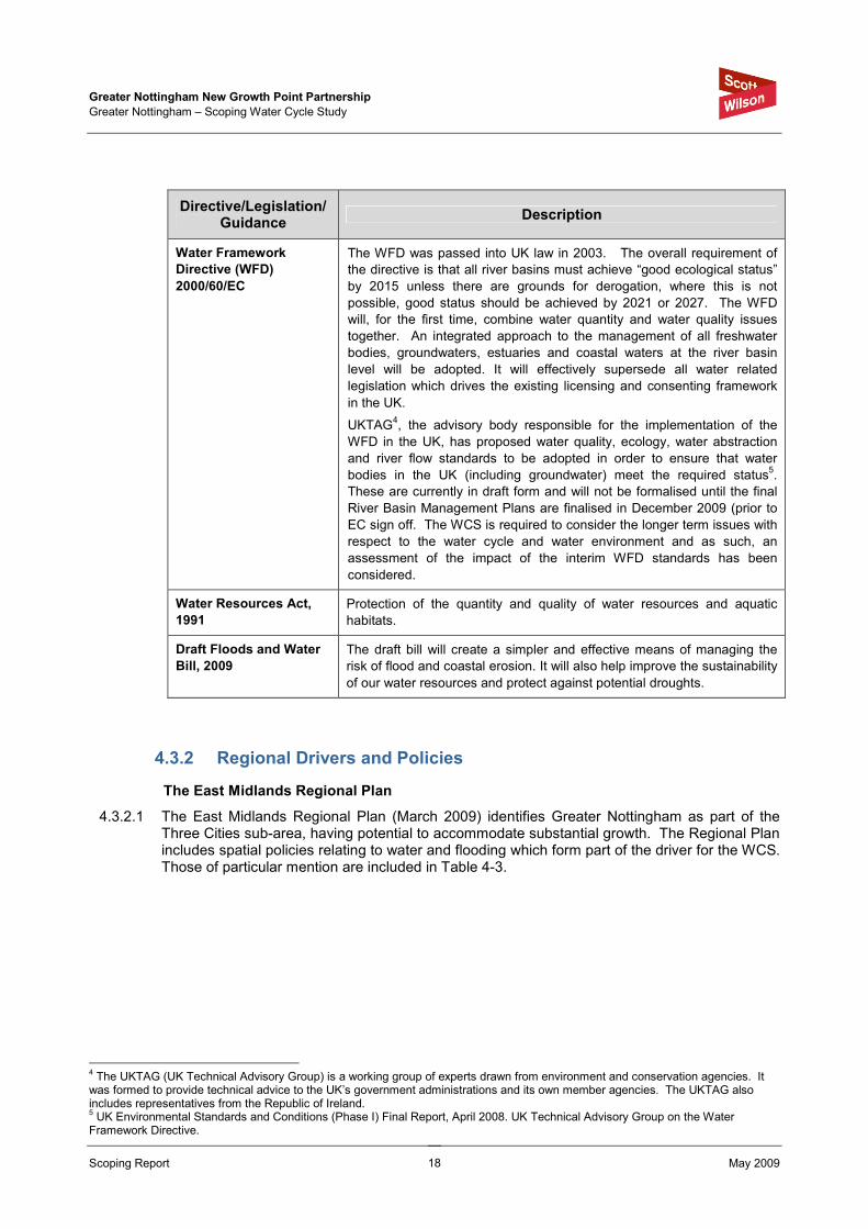
Table 4-2 EU Directives and UK Legislation and Guidance on Water
Directive/Legislation/Guidance
Description
Bathing Waters
Directive 76/160/EEC
To protect the health of bathers, and maintain the aesthetic quality of
inland and coastal bathing waters. Sets standards for variables, and
includes requirements for monitoring and control measures to comply with
standards.
Code for Sustainable
Homes
The Code for Sustainable Homes has been introduced to drive a step-
change in sustainable home building practice, providing a standard for
key elements of design and construction which affect the sustainability of

Greater Nottingham New Growth Point Partnership
Greater Nottingham – Scoping Water Cycle Study
Scoping Report May 2009
17
Directive/Legislation/Guidance
Description
a new home. It will become the single national standard for sustainable
homes, used by home designers and builders as a guide to development,
and by home-buyers to assist in their choice of home.
It will form the basis for future developments of the Building Regulations in
relation to carbon emissions from, and energy use in homes, therefore
offering greater regulatory certainty to developers.
Environment Act 1995 Sets out the role and responsibility of the Environment Agency.
Environmental
Protection Act, 1990
Integrated Pollution Control (IPC) system for emissions to air, land and
water.
Future Water, February
2008
Sets out the Government’s vision for water in England in 2030. The
strategy sets out an integrated approach to the sustainable management
of all aspects of the water cycle, from rainfall and drainage, through to
treatment and discharge, focusing on practical ways to achieve the vision
to ensure sustainable use of water. The aim is to ensure sustainable
delivery of water supplies, and help improve the water environment for
future generations.
Groundwater Directive
80/68/EEC
To protect groundwater against pollution by ‘List 1 and 2’ Dangerous
Substances.
Making Space for Water,
2004
Outlines the Government strategy for the next 20 years to implement a
more holistic approach to managing flood and coastal erosion risks in
England. The policy aims to reduce the threat of flooding to people and
property, and to deliver the greatest environmental, social and economic
benefit.
Planning Policy
Statements and
Planning Policy
Guidance
Planning policy in the UK is set by Planning Policy Statements (PPSs)
They explain statutory guidelines and advise local authorities and others
on planning policy and operation of the planning system.
PPSs also explain the relationship between planning policies and other
policies which have an important bearing on issues of development and
land use. These must be taken into account in preparing development
plans.
A water cycle study helps to balance the requirements of the various
planning policy documents, and ensure that land-use planning and water
cycle infrastructure provision is sustainable.
The most relevant PPSs to WCS are:
PPS1 – Delivering Sustainable Development;
PPS3 – Housing;
PPS12 – Local Development Frameworks;
PPS23 – Planning and Pollution Control; and
PPS25 – Development and Flood Risk.
The Pollution Prevention
and Control Act (PPCA),
1999
Implements the IPPC Directive. Replaces IPC with a Pollution Prevention
and Control (PPC) system, which is similar but applies to a wider range of
installations.
Water Act 2003 Implements changes to the water abstraction management system and to
regulatory arrangements to make water use more sustainable.
Greater Nottingham New Growth Point Partnership
Greater Nottingham – Scoping Water Cycle Study
Scoping Report May 2009
18
Directive/Legislation/Guidance
Description
Water Framework
Directive (WFD)
2000/60/EC
The WFD was passed into UK law in 2003. The overall requirement of
the directive is that all river basins must achieve “good ecological status”
by 2015 unless there are grounds for derogation, where this is not
possible, good status should be achieved by 2021 or 2027. The WFD
will, for the first time, combine water quantity and water quality issues
together. An integrated approach to the management of all freshwater
bodies, groundwaters, estuaries and coastal waters at the river basin
level will be adopted. It will effectively supersede all water related
legislation which drives the existing licensing and consenting framework
in the UK.
UKTAG4, the advisory body responsible for the implementation of the
WFD in the UK, has proposed water quality, ecology, water abstraction
and river flow standards to be adopted in order to ensure that water
bodies in the UK (including groundwater) meet the required status5.
These are currently in draft form and will not be formalised until the final
River Basin Management Plans are finalised in December 2009 (prior to
EC sign off. The WCS is required to consider the longer term issues with
respect to the water cycle and water environment and as such, an
assessment of the impact of the interim WFD standards has been
considered.
Water Resources Act,
1991
Protection of the quantity and quality of water resources and aquatic
habitats.
Draft Floods and Water
Bill, 2009
The draft bill will create a simpler and effective means of managing the
risk of flood and coastal erosion. It will also help improve the sustainability
of our water resources and protect against potential droughts.
4.3.2 Regional Drivers and Policies
The East Midlands Regional Plan
4.3.2.1 The East Midlands Regional Plan (March 2009) identifies Greater Nottingham as part of the Three Cities sub-area, having potential to accommodate substantial growth. The Regional Plan includes spatial policies relating to water and flooding which form part of the driver for the WCS. Those of particular mention are included in Table 4-3.
4 The UKTAG (UK Technical Advisory Group) is a working group of experts drawn from environment and conservation agencies. It was formed to provide technical advice to the UK’s government administrations and its own member agencies. The UKTAG also includes representatives from the Republic of Ireland. 5 UK Environmental Standards and Conditions (Phase I) Final Report, April 2008. UK Technical Advisory Group on the Water Framework Directive.

Greater Nottingham New Growth Point Partnership
Greater Nottingham – Scoping Water Cycle Study
Scoping Report May 2009
19
Table 4-3 Water Related Policies in East Midlands Regional Plan (March 2009)
Policy Description
Policy 32: A
Regional
Approach to
Water
Resource and
Water Quality
“Local Authorities, developers, water companies, the Environment Agency and other relevant public bodies should work together to:
• take water related issues into account at an early stage in the process of identifying land for development and in the phasing and implementation of development, e.g., by undertaking water-cycle studies,
• ensure timely provision of appropriate additional infrastructure for water supply and wastewater treatment to cater for the levels of development provided for in this plan, whilst meeting surface and groundwater quality standards and avoiding adverse impacts on designated sites of nature conservation of international importance,
• asses the scope for reducing leakage of public water supply from current levels,
• promote improvements in water efficiency in new development and in regeneration to achieve a regional target of 25% (equivalent to an average saving of about 35 litres per person per day),
• reduce unsustainable abstraction from watercourses and aquifers to sustainable levels,
• protect and improve water quality and reduce the risk of pollution especially to vulnerable groundwater,
• make provision for the development of new water resources where this represents the most sustainable solution to meeting identified water resource requirements, taking account of predictions of future climate change,
• use sustainable drainage techniques wherever practical to help mitigate diffuse pollution and support groundwater recharge. These will be required where development is upstream of a designated nature conservation site of international importance or to improve water quality, where the need is demonstrated through water cycle studies,
• support ware conservation measures such as winder storage reservoirs on agricultural land,
• ensure that sewage treatment capacity is sufficient to meet the needs of development and that, where necessary improvements are in place so that development does no compromise the quality of discharged effluent”.
Policy 33:
Regional
Priorities for
Strategic
River
Corridors
“The natural and cultural environment of the Strategic River Corridors of the Nene, Trent, Soar, Welland, Witham and Derwent, along with their tributaries, and rivers which contribute to river corridors of a strategic nature in adjoining Regions, should be protected and enhanced.
Local Authorities and other relevant public bodies should work together across regional boundaries to protect and enhance the multi-functional importance of strategic river corridors as part of the Region’s Green Infrastructure, including for wildlife, landscape and townscape, regeneration and economic diversification, education, recreation, the historic environment including archaeology, and managing flood risk”.
Policy 35: A
Regional
Approach to
Managing
Flood Risk
“Local Development Frameworks and the strategies of relevant public bodies should take account of the potential impact of climate change on flooding and land drainage. In particular, they should:
• be informed by Strategic Flood Risk Assessments in order to evaluate actual flood risk. Priority areas for assessment include the built up areas of Derby, Nottingham and Newark,
• include policies which prevent inappropriate development either in, or where there would be an adverse impact on, the coastal and fluvial floodplain areas,
• deliver a programme of flood management schemes that also maximise biodiversity, provide townscape enhancement and other public benefits; and
• require sustainable drainage in all new developments where practicable.

Greater Nottingham New Growth Point Partnership
Greater Nottingham – Scoping Water Cycle Study
Scoping Report May 2009
20
Policy Description
Development should not be permitted if, alone or in conjunction with other new development, it would:
• be at unacceptable risk from flooding or create such an unacceptable risk elsewhere,
• inhibit the capacity of the floodplain to store water,
• impede the flow of floodwater in a way which would create an unacceptable risk elsewhere,
• have a detrimental impact upon infiltration of rainfall to ground water storage,
• otherwise unacceptably increase flood risk,
• interfere with coastal processes.
However, such development may be acceptable on the basis of conditions or agreements for adequate measures to mitigate the effects on the overall flooding regime, including provision for the maintenance and enhancement of biodiversity. Any such measures must accord with the flood management regime for that location”.
4.3.3 Local Drivers and Policies
Local Development Framework
4.3.3.1 The LDFs for the GNNGPP authorities are statutory spatial development plans that comprise a
portfolio of documents including the Core Strategy and the supporting Site Allocation DPDs.
The LDFs will set out the spatial strategies, policies and proposals to guide the future
development and use of land in Greater Nottingham up to 2026. The GNNGPP authorities must
ensure they coordinate and prepare LDF documents and policies. These include preferred
development locations, infrastructure and delivery plans that have had regard to the intent and
steer from national policies, the East Midlands Regional Plan, as well as local aspirations,
needs and demands. The LDFs of the individual authorities should be developed in close
liaison with each other. The establishment of the Joint Planning Advisory Board will ensure a
joined up approach to spatial planning is adopted throughout the study area. Figure 4-1
illustrates the key documents that feed into the LDF.
4.3.3.2 Core Strategies are the overarching DPDs that provide the strategic framework for the other
DPDs and SPDs. In particular, the Site-Specific Allocations and Policies DPD will set out the
sites that will deliver the Core Strategies Spatial Strategy, policies and targets. All these plans
must conform to the Core Strategy and help to deliver its strategic objectives and policies. The
LPAs will also produce SPDs that provide further guidance to support policies in the DPDs.
4.3.3.3 It is essential that these are all informed using the findings and advice from a sound evidence
base that examines economic, social and environmental needs and constraints. This must
include the comprehensive planning, phasing, delivery and management of water, sewerage,
flooding and drainage infrastructure, whilst not adversely affecting environmental capacity. A
critical element is therefore to consider in greater detail, the risks associated from all forms of
flooding and the existing state, limitations and future requirements of the Greater Nottingham
water cycle system in the context of future growth.
4.3.3.4 The LDF process involves an extensive process of consultation. This overall planning process
supports a two stage strategy for the water cycle study, so that important considerations are not
overlooked in between the production of a Scoping WCS and Outline WCS (which inform the
draft LDDs), and the Detailed WCS which, if required, will ensure that the final LDF has

Greater Nottingham New Growth Point Partnership
Greater Nottingham – Scoping Water Cycle Study
Scoping Report May 2009
21
sufficient detail to ensure delivery of the WCS requirements. The WCS will also make
recommendations on phasing for development.
Figure 4-1: Local Development Framework
Key Documents (Source: ADC)
Water Company Planning
4.3.3.5 It is important to consider the planning timelines, both for the GNNGPP authorities in terms of
the LDF but also ST in terms of the funding mechanisms for new water supply and water
treatment infrastructure.
4.3.3.6 There are two elements of Water Company planning that are pertinent to the Greater
Nottingham WCS and specifically with regard to integration with Spatial Planning timelines for
LPAs and Regional Government.
Financial and Asset Planning
4.3.3.7 Water companies currently plan for Asset Management and the financial procurement required
for this through the Asset Management Plan (AMP) process, which runs in 5 year cycles. The
Office of Water Services (OFWAT) is the economic regulator of the water and sewerage
industry in England and Wales, and regulates this overall process.
4.3.3.8 In order to undertake maintenance of its existing assets and to enable the building of new
assets (asset investment), water companies seek funding by charging customers according to
the level of investment they need to make. The process of determining how much asset
investment required is undertaken in conjunction with:
• The Environment Agency (EA) as the regulator determining investment required to improve
the environment,

Greater Nottingham New Growth Point Partnership
Greater Nottingham – Scoping Water Cycle Study
Scoping Report May 2009
22
• The Drinking Water Inspectorate (DWI) who determine where investment is required to
improve quality of drinking water,
• OFWAT who along with the EA require Water Companies to plan sufficiently to ensure
security of supply (of potable water) to customers during dry and normal years.
4.3.3.9 The outcome is a Business Plan which is produced by each Water Company, which sets out
the required asset investment over the next 5 year period, the justification for it and the price
increases required to fund it.
4.3.3.10 Overall, the determination of how much a Water Company can charge its customers is
undertaken by OFWAT. OFWAT will consider the views of the Water Company, the other
regulators (EA and DWI) and consumer groups such as the Consumer Council for Water, when
determining the price limits it will allow a Water Company to set in order to enable future asset
investment. This process is known as the Price Review (PR) and is undertaken in 5 year
cycles. When OFWAT make a determination on a Water Company’s business plan, the price
limits are set for the proceeding five year period allowing the water company to raise the funds
required to undertake the necessary investment which will also be undertaken in that 5 year
planning period (the AMP period).
4.3.3.11 At the time of undertaking the Greater Nottingham Scoping WCS, Water Companies are
preparing for Price Review 2009 (PR09), whereby they are currently drafting their Strategic
Business Plans, which seek funding for asset investment for the 5 year period covering 2010 –
2015 (known as AMP5).
4.3.3.12 It therefore follows that any new asset (or infrastructure) investment required to meet the
requirements of the WCS (and hence future development in Greater Nottingham) needs to feed
into the drafting of the Strategic Business Plan for PR09. OFWAT will determine the final price
limits from this process in November 2009. This ultimately means that there will be no funding
available to undertake significant water cycle infrastructure upgrades until 2010 at the earliest.
It can also be seen that, if significant water cycle infrastructure requirements are not included in
this current price review (PR09), the funding cannot be sought for it until the next Price Review
towards the end of AMP5 (PR14) which would result in funding not being available until AMP6
running from 2015 -2020. Water companies are able to submit interim determinations within
the 5 year AMP cycles to seek funding for unforeseen investment requirements; however it is
considered that infrastructure for planned development should be planned for in sufficient time
for to be included in the relevant Business Plan and Price Review.
Water Resource Planning
4.3.3.13 Water companies are now required to produce Water Resources Management Plans (WRMP)
on a statutory basis covering 25 year planning horizons. WRMPs set out how a water company
plans to provide and invest in existing and new water resource schemes (e.g. reservoirs,
desalination) to meet increases in demand for potable supply, as a result of new development,
population growth and climate change over the next 25 year period. When complete, the new
statutory WRMPs will be updated in 5 yearly cycles to coincide with the Price Review and AMP
process.
4.3.3.14 At the time of undertaking the Greater Nottingham Scoping WCS, ST are in the process of
consulting on their draft WRMP09. This Scoping WCS has made use of the draft WRMP09 to
inform the water resources assessment for growth in Greater Nottingham. However, until such
time as consultation is complete and the WRMP09 is approved and published in 2009, it is not
possible to state with any certainty as to what options will be taken forward.
4.3.3.15 The WCS is therefore essential for several reasons: It allows the discrepancies in the planning
timeframes of ST and the GNNGPP Authorities to be reconciled through strategic planning as

Greater Nottingham New Growth Point Partnership
Greater Nottingham – Scoping Water Cycle Study
Scoping Report May 2009
23
well as providing sufficient evidence base for the GNNGPP Authorities statutory LDF processes
and robust evidence and justification for ST Strategic Business Plans for investment required in
AMP5 (2010-2015) and beyond.

Greater Nottingham New Growth Point Partnership
Greater Nottingham – Scoping Water Cycle Study
Scoping Report May 2009
24
5 Water Cycle Environment and Infrastructure
5.1 Introduction
5.1.1 This section describes the environmental and infrastructure baseline within Greater Nottingham
with regards to the various components of the water cycle. It is important to establish the
baseline and hence spare capacity of the water environment and associated water/wastewater
infrastructure because a basic assumption of the WCS is that it is preferential to maximise the
use of existing facilities without causing negative effects upon the existing water environment.
This is to reduce cost, reduce the impact to existing communities and to allow early phasing of
some new development, negating the need to rely on longer lead in times associated with
securing funding for new infrastructure through the statutory water company planning process.
5.1.2 Initial assessments of the potential impacts from the proposed level of growth in Greater
Nottingham and recommendations for further investigation are provided in Section 6.
5.2 Data Sources
5.2.1 The short timescale for this Scoping WCS means that reliance has had to be placed on existing
reports produced mainly by ST and EA (as per the brief). Although the best publicly available
information has been used for this assessment, it must be recognised that the Periodic Review
Process (AMP5), which ST are currently engaged in with regulators may mean that things may
change in the future. The data sources that have been referred to during this Scoping study, as
well as those that are available for future stages of the WCS are presented in Appendix A.
5.3 Water Resources and Supply
5.3.1 Overview
5.3.1.1 This chapter provides a summary of the water resources and water supply for the Greater
Nottingham area.
5.3.1.2 The water supply for the Greater Nottingham area is provided by ST, the 2nd largest water
company within England and Wales, serving 3.3 Million customers and supplying around 2,000
Million litres per day (Mld-1) This figures represent the total quantity of water put into supply,
including leakage. ST is also provider of wastewater services to the Greater Nottingham area.
5.3.1.3 The water company being the monopoly supplier of services operates its business under a
regulated environment with the EA, OFWAT (the economic regulator) and the DWI. All of these
organisations ensure that ST operates as an efficient water (and sewerage) company, and at
the same time maintains (or where practical improves) the wider environment in which the
company operates.
5.3.2 Climate
5.3.2.1 The average annual rainfall for the Greater Nottingham and Ashfield area is 620mm6, less than
the annual average rainfall for England of 897mm.
6 Environment Agency; Idle and Thorne Catchment Abstraction Management Strategy – Final Document

Greater Nottingham New Growth Point Partnership
Greater Nottingham – Scoping Water Cycle Study
Scoping Report May 2009
25
5.3.3 Watercourses
5.3.3.1 The main watercourses in Greater Nottingham and Ashfield include the River Trent, River
Erewash, River Leen, River Soar, River Derwent and the River Smite (Figure B-2, Appendix B).
River Trent
5.3.3.2 The River Trent bisects the Greater Nottingham administrative area, flowing in a north-easterly
direction through all of the LPAs administrative areas (except Ashfield) across a broad and low
relief, alluvial floodplain. The River Trent rises in the Staffordshire Moorlands and is joined by its
major tributaries in the upper catchment before flowing northeast towards the Humber Estuary.
The Trent catchment is predominantly impervious with the catchment consisting largely of
glacial clay and Alluvium on top of Mercia Mudstone but also of some sandstone and limestone.
The River Trent has little or no hydrological interaction with the underlying aquifer however the
catchment through the study area comprises extensive terrace gravels and alluvium within the
river valleys which maintain its baseflow7.
River Erewash
5.3.3.3 The River Erewash is a tributary of the River Trent comprising a moderate to low relief
catchment which drains carboniferous coal measures with Permian and Triassic bedrock on the
east and southern extents. The river flows from north to south forming the border between
Erewash and Broxtowe into the Attenborough Lakes which discharge into the River Trent.
River Leen
5.3.3.4 The River Leen comprises a moderate to low relief catchment flowing from Gedling through the
centre of Nottingham City towards its confluence with the River Trent near Lenton and has
complicated baseflow hydrology. The River Leen drains from the Permian Mudstone and
Sherwood Sandstone outcrops as it flows south, crossing the boundary between the two units
several times before reaching the River Trent to the south-west of Nottingham.
5.3.3.5 In the past, the Greater Nottingham area contained a large number of springs, many of which
were located to the mudstone/sandstone boundary and drained into local river systems
including the Rivers Leen and Trent. However, many tributaries of these rivers and related
springs have now dried up.
River Soar
5.3.3.6 The River Soar is a major tributary of the River Trent flowing generally northwards through the
East Midlands. The River Soar flows generally northwards along the south-western border of
Rushcliffe where it is joined by Kingston Brook and continues towards its confluence with the
River Trent at Trentlock between Long Eaton and Ratcliff on Soar.
5.3.3.7 The source of the river originates near Hinckley in Leicestershire proceeding to flow north east
through Leicester where it is joined by the Grand Union Canal, River Sence, River Wreake and
Rothley Brook upstream of the Greater Nottingham area.
5.3.3.8 The River Soar catchment is largely characterised by clay and alluvium, which are known as
rapidly responsive to rainfall events8. A review of the National River Flow Archive (NRFA)
7 National River Flow Archives, http://www.nwl.ac.uk/ih/nrfa/station_summaries/028/009.html Accessed 30/03/2009
8 River Trent Catchment Flood Management Plan – Scoping Report, Environment Agency, November 2006, Page 38.

Greater Nottingham New Growth Point Partnership
Greater Nottingham – Scoping Water Cycle Study
Scoping Report May 2009
26
database9 highlighted that the predominant geology in the upper catchment of the River Soar is
characterised by Mercia Mudstone interspersed with beds of Triassic Sandstone and has a
moderate to low relief.
River Derwent
5.3.3.9 Within Greater Nottingham, the River Derwent flows south to the west of Little Eaton before re-
entering the study area as it continues to flow south eastwards from Derby to the south of
Borrowash and Draycott.
5.3.3.10 The source of the River Derwent originates in the Peak District at Bleaklow to the east of
Glossop and flows south eastwards through the Upper Derwent Valley sourcing a number of
reservoirs (Howden, Derwent and Ladybower). It then continues through numerous villages of
rural Derbyshire where it is joined by the River Wye at Rowsley and the River Amber at
Ambergate continuing south before being redirected eastwards at Derby. The Derwent, a major
tributary of the River Trent reaches their confluence east of Shardlow.
River Smite
5.3.3.11 The River Smite flows north eastwards through the eastern area of Rushcliffe in proximity to the
settlements of Barnstone, Aslockton and Flawborough. The river is joined by the River Whipling
east of Aslockton and is a tributary of the River Devon flowing northwards immediately north
east of the study area boundary.
Other Watercourses
5.3.3.12 In addition to these major watercourses, there is an extensive system of streams and smaller
watercourses. Some of the notable smaller watercourses in the study area include:
• Day Brook,
• River Whipling,
• Kingston Brook,
• Fairham Brook,
• Nethergate Brook,
• Dover Beck,
• Ouse Dyke,
• Crock Dumble,
• Baker Lane Brook,
• Lambley Dumble,
• Woodborough Brook,
• Tinkers Leen,
• Tottle Brook,
• Robins Wood Dyke,
• Beauvale Brook,
• Boundary Brook,
• Nut Brook,
• Ock Brook,
• Golden Brook.
9 National River Flow Archives, http://www.nerc-wallingford.ac.uk/ih/nrfa/station_summaries/028/093.html, Accessed 30/03/2009.

Greater Nottingham New Growth Point Partnership
Greater Nottingham – Scoping Water Cycle Study
Scoping Report May 2009
27
5.3.3.13 There is also a network of used and disused canals in the region (including the Nottingham
Canal, Beeston Canal, Erewash Canal and the Grantham Canal) which were developed
through the region following the Industrial Revolution and many of which are still in regular use
to this day.
5.3.3.14 In addition to these other watercourses (waterbodies) within the study area, other notable
watercourses in Ashfield include:
• River Idle,
• River Maun,
• River Meden,
• Skegby Brook,
• Cauldwell Brook,
• Bagthorpe Brook.
5.3.4 Geology and Groundwater
5.3.4.1 The Greater Nottingham area is underlain by a Major Aquifer, a Minor Aquifer and a Non-
Aquifer. A simplified summary diagram of the different aquifer types underlying Greater
Nottingham is shown in Figure 5-1.
5.3.4.2 Much of region in the north of Greater Nottingham is underlain by the unconfined Permo-
Triassic Sherwood Sandstone, a major aquifer10 with little or no drift protection and is therefore
vulnerable to pollution. This Major Aquifer is peppered with a series of Source Protection
Zones (SPZs) from which abstractions take place from the underlying Sandstone Aquifer. In the
north-west of Greater Nottingham lies an area of Cadeby Formation (also known as the
Permian Magnesian Limestone), a major aquifer11 and which is separated from the Sherwood
Sandstones by a layer of Permian Marls which act as an aquiclude12. The Sherwood
Sandstones, in both their confined and unconfined areas, have been extensively developed for
both public water supply and industrial uses within Greater Nottingham.
5.3.4.3 The Sherwood Sandstones across a majority of Nottingham City and most of the area to the
east and west of the Greater Nottingham region are overlain and confined by Mercia
Mudstones, a non-aquifer13.
5.3.4.4 The Coal Measures to the west of the Cadeby Formation are classified as a minor aquifer.
10 A Major Aquifer is Highly Permeable strata usually with a known or probable presence of significant fracturing
11 Minor Aquifers are fractured or potentially fractured rocks which do not have a high primary permeability of other formations of
variable permeability. 12 An aquiclude is an impermeable layer which will impede flow between two aquifer units.
13 A Non aquifer is a formation with negligible permeability that is generally considered as containing insignificant quantities of
groundwater.

Greater Nottingham New Growth Point Partnership
Greater Nottingham – Scoping Water Cycle Study
Scoping Report May 2009
28
Figure 5-1: Simplified Location of Main Aquifers around Greater Nottingham Key – CM Coal Measures, CF Cadeby Formation, SS Sherwood Sandstone
5.3.5 Types of Abstraction Sources
5.3.5.1 With the presence of a major aquifer beneath Nottingham, it is to be expected that the Permo-
Triassic Sandstones is an important source of water supply. Throughout the long industrial
history of Nottingham, this aquifer has been heavily exploited and consequently major changes
to the groundwater flow and quality have occurred. To meet the increased growth in demand
over the centuries, a connection to the City has also been made from Derwent Reservoirs in the
Peak District.
5.3.5.2 ST currently obtains approximately 50% of Greater Nottingham’s water supply from surface
water abstractions and 50% from groundwater abstractions.
5.3.6 Groundwater Abstractions
5.3.6.1 The Environment Agency’s public register of abstraction licences shows over 60 licensed
sources within the Greater Nottingham area. An examination of trends in abstraction in
Nottingham shows that at least within the Wollaton Groundwater Unit, abstraction has
significantly reduced since 1979. Most of the decline has been due to abstractions ceasing from
MMiinnoorr
AAqquuiiffeerr
((CCMM))
MMaajjoorr
AAqquuiiffeerr
((SSSS))
NNoonn AAqquuiiffeerr
Major Aquifer
(CF)

Greater Nottingham New Growth Point Partnership
Greater Nottingham – Scoping Water Cycle Study
Scoping Report May 2009
29
a few large industrial sources. This feature, which can be seen in Figure 5-2, shows openings
in the total catchment areas to the east of the city. The response of groundwater levels to these
changes in abstraction are discussed further in Section 5.5.3.
Figure 5-2: Location of Source Protection Zones around Greater Nottingham (Source: Environment Agency)

Greater Nottingham New Growth Point Partnership
Greater Nottingham – Scoping Water Cycle Study
Scoping Report May 2009
30
5.3.6.2 In general, there are more licensed sources within the unconfined Sandstones than the
confined section of the aquifer. The EA SPZ maps for the major licensed sources beneath
Nottingham show that virtually every part of both the unconfined and confined aquifer is
currently utilised (with the exception of boreholes shut down) and therefore an ‘over-licensed’
status can be expected when the CAMS for Groundwater Units within this area are published
by the EA.
5.3.6.3 ST operates nine borehole sources within the Greater Nottingham area. The total licensed
quantities from these sources are approximately 130 Mld-1. However, the actual amount of
water abstracted is likely to be much less than this, mainly due to water quality problems at a
number of these sources.
5.3.6.4 Nitrate in groundwater supplies is a major issue facing ST. The main source of nitrate is likely
to be form agricultural inputs, which may or may not change in the future. The issue is ‘key’ to
achieving compliance with the Water Framework Directive in the future (see section 5.5.4).
5.3.7 Surface Water Abstractions
5.3.7.1 To supplement the groundwater supplies to the Greater Nottingham area, ST transfers water
into the area from the Derwent Catchment by two different methods. The first method is a
‘direct’ transfer from the Derwent Reservoirs, via an aqueduct (in this case an enclosed
pipeline) direct to local Water Treatment Works (WTWs). The second method is by indirect
transfer, which involves making releases from the Howden, Derwent and Ladybower reservoir
systems into the River Derwent. This allows the water to flow down the river system and which
can then abstracted at either Little Eaton WTW to the north of Derby or at Draycott WTW to the
south of Derby. In practice, most of the water released from the Derwent Reservoirs to the
River Derwent is used to provide downstream flow to the river, rather than for re-abstraction for
public water supply.
5.3.7.2 Instead ST makes use of releases from the Carsington Reservoir to the River Derwent at
Ambergate for re-abstraction from the Derwent downstream at Little Eaton and Draycott, in
order to supply the Nottingham area.
5.3.7.3 The ’indirect’ transfer method of abstraction is considered to be more environmentally friendly
as it safeguards the river better than abstracting water out of the headwaters of Derwent
Catchment and transferring it directly to the Nottingham area. Abstractions from the Derwent
Catchment are the subject of a review by the EA due to the important conservation and amenity
value of this river system.
5.3.7.4 The ST abstraction licences within Derwent Catchment permit up to 186 Mld-1 to be abstracted
from this reservoir system.
5.4 Catchment Abstraction Management Strategies
5.4.1.1 The EA manages water resources at the local level through the use of Catchment Abstraction
Management Strategy (CAMS). The Greater Nottingham area lies within both the Lower Trent
and Erewash (LT&E) CAMS area and the Idle and Torne (I&T) CAMS area. The Nottingham
area also receives water from the Derbyshire Derwent catchment by the methods as described
in Section 5.3.
5.4.1.2 Within the various CAMS, the Environment Agency’s assessment of the availability of water
resources is based on a classification system that gives a resource availability status and
indicates:

Greater Nottingham New Growth Point Partnership
Greater Nottingham – Scoping Water Cycle Study
Scoping Report May 2009
31
• The relative balance between the environmental requirements for water and how much is
licensed for abstraction,
• Whether water is available for further abstraction,
• Areas where abstraction needs to be reduced.
5.4.1.3 The categories of resource availability status are shown in Table 5-1. The classification is
based on an assessment of a river system’s ecological sensitivity to abstraction-related flow
reduction. This classification can then be used to assess the potential for additional water
resource abstractions.
Table 5-1: CAMS resource availability status categories
Indicative Resource Availability Status License Availability
Water Available Water is likely to be available at all flows including low flows. Restrictions may apply.
No Water Available No water is available for further licensing at low flows. Water may be available at higher flows with appropriate restrictions.
Over Licensed
Current actual abstraction is such that no water is available at low flows. If existing licences were used to their full allocation they could cause unacceptable environmental damage at low flows. Water may be available at high flows, with appropriate restrictions.
Over Abstracted Existing abstraction is causing unacceptable damage to the environment at low flows. Water may still be available at high flows, with appropriate restrictions.
5.4.1.4 Most of Greater Nottingham lies within the LT&E CAMS area and the Sherwood Sandstone
(SS) Groundwater Management Unit (GWMU), which underlies Nottingham City (see section
5.3.3). The SS is broken down into a number of sub-units, the Wollaton Unit beneath
Nottingham City and the Ravenshead South Unit for the area to the north of the City. Also to
the north of City lies the Hucknall Unit, which incorporates the Cadeby Formation (the Permian
Magnesium Limestone). Some of the Ashfield BC’s area lie within parts of the I&T CAMS area.
5.4.1.5 Details of the Derwent CAMS are also included, as although no parts of Greater Nottingham are
included in this area, the city does receive some of its water supply from this area.
5.4.1.6 The CAMS classification for these different units around Greater Nottingham is shown in Table 5-2.

Greater Nottingham New Growth Point Partnership
Greater Nottingham – Scoping Water Cycle Study
Scoping Report May 2009
32
Table 5-2: Water Resources within Catchment around Greater Nottingham
Resource availability status WRMU/GWMU
name Associated main river Individual
WRMU status Integrated
WRMU status Target status in 2012/3
Target status in 2018/9
WRMU1 - River Trent
1
River Trent Water Available Water Available Water Available Water Available
WRMU3 – Wollaton GW
1 Wollaton SS
GWMU Over Licensed Over Licensed Over Licensed No Water
Available
WRMU2 – Dover Beck
1
Dover Beck & Ravenshead South SS GWMU
Over Abstracted Over Abstracted Over Abstracted Over Abstracted
WRMU4 – Leen and Limestone
1
River Leen & Hucknall PML
GWMU
No Water Available
No Water Available
No Water Available
No Water Available
WRMU4 - River Idle
2 River Idle Over Abstracted Over Abstracted Over Licensed Over Licensed
WRMU1 - River Upper Meden
2
River Upper Meden
Water Available No Water Available
No Water Available
No Water Available
WRMU1 – Upper Derwent
3
River Derwent Over Licensed Over Licensed Over Licensed Over Licensed
Key: Integrated WRMU status in table refers to the availability status after downstream conditions have been taken into account and/or, in the case of groundwater, the status of an overlying river. 1 Lower Trent and Erewash CAMS
2 Idle and Torne CAMS
3 Derbyshire Derwent CAMS
5.4.1.7 A groundwater model of Nottinghamshire has recently been completed by the EA. The model
and its findings will be used to assist the EA with the implementation of its strategy for
managing groundwater resources in both the Trent, Idle and Torne catchments. Details from
the Nottinghamshire Groundwater Model and its findings should be sought during the Outline
WCS.
5.4.1.8 According to the EA, the Greater Nottingham area lies within a zone of ‘moderate’ water stress.
Water stress occurs when water demand exceeds availability during a period of time. The
basis of this assessment is the current water resources situation and the level of demand
expected in the future. The aim of the water stress indicator is to make sure that water
companies and water users do not disregard the environmental consequences of the
abstractions taking place in their area.
5.5 Severn Trent Water - Water Supply Strategy
5.5.1 Water Resource Zone 6
5.5.1.1 For the purposes of water resources planning, Nottingham is situated within STs East Midlands
Water Resource Zone (WRZ) - Number 6. This zone covers the three counties of Derbyshire,
Nottinghamshire and Leicestershire. Nottingham lies in the centre of WRZ 6. Figure 5-3 shows
STs various WRZs. Also shown on this figure is the network of strategic treated water transfer
grid (shown as a solid black line), which enables the transfer of water from Derbyshire into
Warwickshire, or back into Leicestershire if required.

Greater Nottingham New Growth Point Partnership
Greater Nottingham – Scoping Water Cycle Study
Scoping Report May 2009
33
Figure 5-3: Severn Trent Water Resource Zones and Strategic Water Transfer Grid
5.5.2 Growth Forecasts – Draft and Final WRMPs
5.5.2.1 The forecasts contained within STs draft WRMP (April 2008), and in some cases revised in STs
response to consultation (February 2009) indicates the following growth over the next 25 years
within WRZ 6:
• The East Midlands (WRZ 6) originally indicated a significant (water resource) deficit (i.e.
demand greater than supply) from 2016. This has now changed to show a surplus of
resources over the entire planning period through to 2035. It is understood that these
changes are the result of revised assessment of climate change impacts on resources and
also updated demand forecasts in the light of comments received on the draft WRMP. Until
the final WRMP is published (subject to approval by DEFRA), these figures cannot be
considered final,
• STs draft WRMP growth forecasts include for both RSS figures and New Growth Point
Strategy. The combined growth in Derby, Leicester and Nottingham is for 81,500 new
homes and estimate an increase in domestic (water resource) demand of between 22 Ml/d
and 28 Ml/d (based on a consumption of 135 l/h/d and between 2 and 2.5 persons per
property). The statement of response February 2009 contains reference to the fact that
demand forecasts have reduced but no other details are provided,
• The total population of WRZ 6 is currently 2,900,000 rising to 3,200,000 by 2035. Again,
no further details are provided in the statement of response (February 2009). Currently the
NOTTINGHAM

Greater Nottingham New Growth Point Partnership
Greater Nottingham – Scoping Water Cycle Study
Scoping Report May 2009
34
population within the Greater Nottingham area is approximately 761,400 and set to grow to
nearly 824,000 by 2026 (not including the northern part of Ashfield)14.
5.5.3 Water Efficiency
5.5.3.1 As a result of the changes described above, the emphasis for STs final WRMP is expected to
focus, at least in the short term, on demand management and improved water efficiency.
5.5.3.2 At the present time, STs metered customers, which represent 27% of its customer base, use
117 l/h/d and its un-metered customers use 146 l/h/d. The overall average figure is 138 l/h/d
(OFWAT 2006/07). A comparison with average water company customers is shown in Table
5-3.
Table 5-3: Summary of water usage by various groups of water customers
Customer type 2006-07 report*1 Average Customer*
2
Metered 117 l/h/d 152 l/h/d
Unmetered 146 l/h/d 133 l/h/d
Overall 138 l/h/d 146 l/h/d
Source: OFWAT 2006/07 *1 ST’s customers *2 English and Welsh customers
5.5.3.3 A summary of the STs approach to water efficiency included in their draft WRMP (April 2008) is
as follows:
• Water Metering – ST intend to actively encourage customers to opt for a water meter. No
targets have been set for 2020, but 66% will be metered by 2035,
• Tariffs – no changes are planned in this area,
• Water Efficiency – Good practice guidance is followed where possible (OFWAT 2006),
• Leakage – ST are proposing to operate at sub ELL (Economic Level of Leakage) in their
areas of most stressed areas, this includes the Greater Nottingham area.
5.5.3.4 STs statement of response to their draft WRMP (February 2009) has incorporated the most
recent evidence, which predicts that greater uptake of the free meter option will take place
between 2010 and 2015, and also in the longer term. Until the final WRMP is published in April
2009, then no further details are available. The statement of response also mentions that the
trial to install a meter on a ‘change of occupier’, which was earmarked for only one WRZ, will
now instead be extended to all zones in effort to increase metering.
5.5.4 Potential Risks to Supply
5.5.4.1 The potential risks to STs supply may come from a number of areas, including:
• Groundwater quality within its aquifers – ST forecast that by 2035 increasing nitrate
concentrations will mean that many of its groundwater sources will no longer be suitable for
water supplies (August 2008). The main source of nitrate is from agricultural inputs, (which
may or may not change in the future),
• Rising groundwater levels – these have been observed in some parts of the Nottingham
area, with the flooding of basements being noted in and around Nottingham city centre. An
assessment of groundwater levels undertaken by researchers from the University of
Sheffield found no consistent pattern, in some place groundwater levels were rising, whilst
14 Source: Nottingham City Council, 2009

Greater Nottingham New Growth Point Partnership
Greater Nottingham – Scoping Water Cycle Study
Scoping Report May 2009
35
in others they were falling. It is not clear whether the areas where abstractions have
ceased have seen a rise in groundwater levels. No specific information has been provided
by the Councils so far to contradict the University of Sheffield research and this should be
investigated further as part of an Outline study. Leakage from water mains and sewer
networks may explain some of the responses observed,
• Climate change – this principally affects surface water systems, such as the Derwent
Reservoirs. Although the effects of climate change on Deployable Output are likely to be
less extreme than originally thought in the draft WRMP, it is nonetheless the case that the
situation will need to be monitored closely in the coming years ahead,
• Review of Consents process – STs draft WRMP (April 2008) mentioned that the aquifer in
Nottinghamshire is under pressure from abstractions and that two low flow sites have had
compensation discharges introduced. River abstractions from the Upper Derwent River
were also under review to safeguard the conservation and amenity value of this river. It is
not known what the outcome of the review has been and whether any further investigations
will be required at these sites. Further details have now been provided by the Environment
Agency, however until a final decision of what schemes will be funded by OFWAT (see
section 4.3.3), then it is unclear what the outcome will be. Further consideration of these
matters is to be included in the Outline stage,
• Water Framework Directive (WFD) – STs Business Plan (August 2008) contains details of
catchment solutions, to be implemented instead of and in parallel to treatment solutions, for
both nitrate and other water quality problems. The work proposed for 2005-10 should help
influence and inform how ST implements the WFD River Basin Management Plan Cycles.
5.5.5 Next stage – Outline Strategy
5.5.5.1 The next stage of the WCS will include:
• A full assessment of the additional demand from the new growth (both from the extra
homes and jobs),
• A review of the spare licence quantities available form sources within Greater Nottingham
and its surrounding areas,
• A review of the options for meeting the extra water demand required, including in the area
of demand management,
• Developing an assessment tool which grades the level of infrastructure required to support
growth and the relative scale of investment required.
• Further consideration of the impacts of additional abstractions on the wider water
environment, including obtaining details of the Nottinghamshire Groundwater Model which
has been developed by the EA.

Greater Nottingham New Growth Point Partnership
Greater Nottingham – Scoping Water Cycle Study
Scoping Report May 2009
36
5.6 Flood Risk
5.6.1 Source-Pathway-Receptor
5.6.1.1 The aim of identifying the potential sources of flood risk to the study area is to assess the risk of
all forms of flooding to and from the development, in order to identify any potential development
constraints with respect to flood risk. PPS25 emphasises the need for a risk-based approach to
be adopted by LPAs through the application of the Source-Pathway-Receptor model.
5.6.1.2 The model firstly identifies the Sources of flooding to and from the development. The
identification is based on a review of local conditions and consideration of the effects of climate
change. The nature and likely extent of flooding arising from any one source is considered, e.g.
whether such flooding is likely to be localised or widespread. The presence of a flood source
does not always infer a risk.
5.6.1.3 The exposure Pathway or ‘flooding mechanism’ determines the risk to the receptor and the
effective consequence of exposure, e.g. sewer flooding does not necessarily increase the risk
of flooding unless the sewer is local to the site and ground levels encourage surcharged water
to accumulate.
5.6.1.4 The varying effect of flooding on the Receptors depends largely on the sensitivity of the target.
Receptors include any people or buildings within the range of the flood source, which are
connected to the source by a pathway.
5.6.1.5 In order for there to be a flood risk, all the elements of the model must be present. Furthermore
effective mitigation can be provided by removing one element of the model, e.g. by removing
the pathway or receptor. With regard to fluvial flood risk, this can be achieved by moving the
proposed development wholly into Flood Zone 1.
5.6.1.6 The other major potential source of flooding is surface water flooding, which can occur as a
result of a number of factors. During periods of prolonged rainfall events and intense
downpours, overland flow from adjacent higher ground may ‘pond’ in low-lying areas of land
without draining into watercourses, surface water drainage systems or the ground. In general,
surface water drainage systems are only required to be designed to contain a 1 in 30 year
rainfall event (as a maximum). During higher intensity events, surface water drainage systems
become overwhelmed often resulting in surface water flooding.
5.6.1.7 One of the main issues with surface water flooding is that in areas with no history, relatively
small changes to hard surfacing and surface gradients can cause flooding (garden loss and
reuse of brownfield sites). As a result, continuing development could mean that surface water
flooding can become more frequent and although not on the same scale as fluvial flooding, it
can still cause significant disruption. The use of SuDS can mitigate against surface water
flooding.
5.6.1.8 A review of flood risk in the WCS is essential to ensure that the risk of flooding to new
development and that new development is steered away from high risk areas (EA Flood Zone 2
and Flood Zone 3). It will also ensure that any flood mitigation measures are planned in a
strategic manner. It is also essential that there is no deterioration to existing neighbouring
communities’ standards of protection, or subsequent increases in flood risk.
5.6.2 Watercourses and Associated Flood Risk
5.6.2.1 As previously noted, the main water-bodies flowing through the Greater Nottingham study area
include the River Trent, River Derwent, River Erewash, River Leen, River Soar and the River
Greater Nottingham New Growth Point Partnership
Greater Nottingham – Scoping Water Cycle Study
Scoping Report May 2009
37
Smite. The EA Flood Zones for each of the watercourses are shown in Figure B-3 (Appendix
B) and are summarised below.
River Trent
5.6.2.2 Severe flooding can occur from the reach of the River Trent through Greater Nottingham during
times of high flows, this can be exacerbated when these high flows coincide with high tides in
the Humber Estuary downstream which prevent free discharge. The potential effects are also
made worse by predominant low-lying nature of the land in much of the River Trent floodplain,
which is easily inundated and difficult to drain.
5.6.2.3 Flow in the River Trent along the reach through Greater Nottingham is influenced by public
water supply abstraction, groundwater abstraction, recharge and effluent returns.
5.6.2.4 There are extensive areas of Flood Zone 2 and Flood Zone 3 extending out from both banks
through southern part of Nottingham, into the settlements of Long Eaton, Toton, Attenborough,
Rylands, Beeston, Clifton, Wilford, West Bridgford, Lenton, Adbolton, Colwick, Netherfield,
Radcliffe on Trent, Stoke Bardolph and Burton Joyce. There are also numerous smaller
settlements and agricultural land that lie within the wide River Trent floodplain through the
Greater Nottingham study area.
5.6.2.5 Flood defences are present along significant reaches of the River Trent. Following the EA’s
Fluvial Trent Flood Risk Management Strategy (March 2005), plans for two Flood Alleviation
Schemes (FAS) have been progressed. These are the West Bridgford FAS and the Nottingham
Trent Left Bank FAS. The West Bridgford FAS was completed in September 2007 and has
reduced flood risk to 5,636 properties in the West Bridgford area, by improving the standard of
protection to the 1 in 100 year (1% annual probability) event. The Left Bank FAS is still at
planning stage and construction has not yet commenced. The construction period is 3 years
and the scheme is designed to protect the existing population from flooding up to a 1 in 100
year flood event. The proposed improvements do not remove the risk of flooding to the
conurbation.
River Derwent
5.6.2.6 The highest flood risk area for the River Derwent is in the lower reaches, which is currently
protected to a standard of less than 1%. The Derwent floodplain extends into EBC in the south
west of the study area where it poses a flood risk to the settlements of Little Eaton, Borrowash,
Draycott and Sawley.
River Erewash
5.6.2.7 The floodplain of the River Erewash poses a risk of flooding to the settlements of Jacksdale, Eastwood, Ilkeston, Trowell, Stapleford, Sandiacre and Long Eaton. Generally, the flooding pathway is overtopping of raised embankments and overland flow. Flood levels in the River Erewash near to Sandiacre and Stapleford may be increased by high water levels backing up from the River Trent.
River Leen
5.6.2.8 The Ashfield District SFRA highlights that development in Hucknall could have significant implications to flood risk downstream in Nottingham. The key settlements at risk of flooding from the River Leen have been identified as those of Papplewick, Bulwell, Old Basford, New Basford, Whitemoor, Radford and Lenton.

Greater Nottingham New Growth Point Partnership
Greater Nottingham – Scoping Water Cycle Study
Scoping Report May 2009
38
River Soar
5.6.2.9 The River Soar poses a risk of flooding to areas of agricultural land and settlements along the
western boundary of Rushcliffe including Sutton Bonington, Normanton on Soar and Stanford
on Soar. Kingston Brook, a tributary of the River Soar flows westwards through Rushcliffe
posing a particular flood risk to areas of East Leake and Kingston on Soar.
River Smite
5.6.2.10 The settlements of Colston Bassett, Barnstone, Aslockton and Flawborough lie within the
largely rural River Smite floodplain through Rushcliffe.
Other Watercourses
5.6.2.11 Fairham Brook - a tributary of the River Trent flowing generally north westwards through
Rushcliffe and its smaller tributary of Roehoe Brook pose a risk of flooding to the village of
Widmerpool. Nethergate Brook, a small tributary of Fairham Brook also poses a risk of fluvial
flooding to the centre of Clifton.
5.6.2.12 Day Brook - a tributary of the River Leen, Day Brook poses a flood risk to the settlement of
Arnold between Daybrook an Old Basford, as identified in the River Leen and Day Brook SFRA.
5.6.2.13 Car Dyke - extends north eastwards from Bingham through a largely rural area towards the
River Dean located immediately north east of the Rushcliffe boundary. The floodplain of Car
Dyke is not considered to pose a significant risk of flooding to adjacent settlements within this
area of Rushcliffe.
5.6.2.14 River Whipling - a tributary of the River Smite, poses a risk of flooding to the rural eastern area
of Rushcliffe. However no significant risk is apparent to any urban settlements.
5.6.2.15 Dover Beck - a main watercourse running south eastwards in proximity to, but outside, the
eastern boundary of Gedling. Multiple tributaries of this watercourse flow generally eastwards
through the Gedling area. The broad extent of Flood Zone 2 and Flood Zone 3 of these
watercourses in relation to settlements in this area is minimal; although those of Lambley Beck
Dumble Beck and Cocker Beck do coincide with the village of Lambley, and those of
Woodborough Brook also coincide with the village of Woodborough, posing a potential flood
risk to these settlements.
5.6.2.16 Bagthorpe Brook - a tributary of the River Erewash poses a risk of fluvial flooding to the
settlement of Westwood, south of Jacksdale in Ashfield.
5.6.2.17 Beauvale Brook and Gilt Brook - pose a risk of fluvial flooding to the northern and south
eastern urban edges of Eastwood (in Broxtowe) respectively before discharging into the River
Erewash.
5.6.2.18 Nut Brook and Stanley Brook - pose a risk of flooding to mainly agricultural land in the vicinity
of West Hallam before proceeding to pose a risk to the urban settlements of Kirk Hallam and
Stanton towards the River Erewash (in Erewash).
5.6.2.19 Ock Brook - poses a risk of fluvial flooding through the centre of the settlements of Ockbrook
and Borrowash, and Golden Brook poses a risk of flooding to the western and eastern edges of
Breaston, both in the EBC area.
5.6.2.20 Baker Lane Brook – presents a risk of flooding to properties in Hucknall.

Greater Nottingham New Growth Point Partnership
Greater Nottingham – Scoping Water Cycle Study
Scoping Report May 2009
39
5.6.3 Canals
5.6.3.1 The Nottingham, Erewash, Beeston, Grantham and Erewash canals are all situated within the
study area. Flood risk posed by the canals is at present un-quantified but they can represent as
a potential flood risk. Flooding resulting from overtopping of the Nottingham Canal has
previously been recorded in Cossall (in Broxtowe).
5.6.4 Surface Water Flooding
5.6.4.1 Surface water flooding is a serious issue in built up areas within Greater Nottingham due to the
extensive coverage of impermeable area. This is particularly true within Nottingham City. It is
imperative that the WCS considers (using available data as a basis) the potential increase in
flood risk caused by new development and seeks to identify mitigation measures wherever
feasible.
5.6.4.2 Level 2 SFRAs were completed for all six districts of the Greater Nottingham area in July 2008.
In addition to this are the Level 2 SFRA for the River Leen and Day Brook catchments,
completed in September 2008 and the Ashfield District Level 1 SFRA, completed in 2009. All of
the SFRAs have been undertaken in accordance with Planning Policy Statement 2515 (PPS25)
and the Practice Guide16. The SFRAs provide information on the flood risk from fluvial, tidal,
surface, ground and artificial water sources and will be used by each council to apply the
Sequential Test.
5.6.4.3 The SFRAs will be used to support the emerging LDFs for the Greater Nottingham Authorities
and will also be an invaluable source of information for the later stages of the Greater
Nottingham WCS.
5.6.4.4 The initial review of the SFRAs has identified the key flood risk issues in the study areas and
indicates further review of flood risk, particularly with regards to surface water and sewer
flooding, should be undertaken as part of the Outline WCS.
5.6.4.5 All of the SFRAs highlight surface water flooding as a key issue that needs to be addressed
when new development is taking place. The River Leen and Day Brook SFRA places particular
emphasis on the need for holistic management of surface water across all of the councils areas.
It states that:
“The flooding experienced from the River Leen and Day Brook can be attributed to a
legacy of unattenuated surface water run-off generated by historic urban development
within the areas of Nottingham City Council that drain both by natural topography and via
the sewer network to the River Leen and Day Brook.”
5.6.4.6 The SFRA goes further explaining that when climate change and the expected associated
increases in frequency of wetter winters and intense rainfall occur,
“even maintaining the status quo in terms of volumes and peak run off rates may no longer
be acceptable. In order to improve the flooding situation downstream and promote more
sustainable forms of development the SFRA recommends the accepted starting point for
discussions with developers and for determination of planning applications should be a
reduction in surface water run off”
15 Planning Policy Statement 25 ‘Development and Flood Risk’ – Department for Communities and Local Government, December
2006. 16 Planning Policy Statement 25 ‘ Development and Flood Risk’, Practice Guide – Department for Communities and Local
Government, June 2008.

Greater Nottingham New Growth Point Partnership
Greater Nottingham – Scoping Water Cycle Study
Scoping Report May 2009
40
5.6.4.7 Both the River Leen and Day Brook SFRA and draft Ashfield SFRA identify strict surface water management in new development in Hucknall as critical to avoiding increasing flood risk downstream in Nottingham City.
Table 5-4: Key SFRA Findings
SFRA Key Flood Risk Issues Identified
River Leen and
Day Brook
Major overtopping of flood defences in Bulwell, Basford, Bobbers Mill, Radford,
Sherwood
Majority of flooding on River Leen and Day Brook attributed to urban development.
Need to decrease peak flow volume and run off rates
Groundwater flooding experienced in basements in Basford
Ashfield Main fluvial flood risk associated with Baker Lane Brook and River Leen
Development in Hucknall could significantly increase flooding downstream in
Nottingham City
Broxtowe
(GNSFRA)
Fluvial risk from:
Beauvale Brook on the right bank near cricket pitch
Boundary Brook upstream of trowel Road, Devonshire Drive, Roehampton Drive
River Erewash- Stapleford
River Trent- Beeston, Toton, Stapleford, Ryelands
Erewash
(GNSFRA)
Fluvial flood risk from:
River Erewash- Ilkeston, Sandiacre, Long Eaton
River Trent- Long Eaton, Sawley
Ock Brook- Ockbrook
River Derwent- Church Wilne, Draycott
Gedling
(GNSFRA)
Fluvial flood risk from:
Ouse Dyke- north side of Main Road
River Leen- Papplewick Lane
Day Brook- Thackerys Lane, Knighton Road, Mansfield Road
River Trent- Colwick, Netherfield, Stoke Bardolph, Burton Joyce
Surface Water flooding is a serious concern and development can worsen flood risk
downstream
City of
Nottingham
(GNSFRA)
Fluvial flood risk from:
River Trent- City centre, Lenton
Fairham and Nethergate Brook
Extensive flooding along the Leen corridor
Development upstream in Gedling and Hucknall can potentially increase flood risk if
surface water isn’t managed
Rushcliffe
(GNSFRA)
Fluvial flood risk from:
River Trent- West Bridgford, Holme Pierrepont
River Smite- Aslockton, Barnstone

Greater Nottingham New Growth Point Partnership
Greater Nottingham – Scoping Water Cycle Study
Scoping Report May 2009
41
5.7 Wastewater Treatment and Collection
5.7.1 Wastewater Responsibilities
5.7.1.1 Severn Trent (ST) are responsible for the operation and maintenance of the existing foul
sewerage system and surface water drainage network within Greater Nottingham and Ashfield.
However, ST are not responsible for soakaways, land drainage, highways drainage, SuDS or
septic systems.
5.7.2 Wastewater Infrastructure
5.7.2.1 It is clearly useful to identify areas where new development could put pressure on the sewage
treatment infrastructure and where there is a particular problem with nutrient enrichment.
Nitrates and phosphates come from a range of sources, principally agriculture and treated
sewage effluent. If some wastewater treatment works (WwTWs) increase in size they may be
required to significantly reduce the amount of phosphate they discharge. Key to assessing
wastewater capacity is not just the location of proposed development, but the type and the
timing (start, duration, phasing etc.) of development. At that point any additional investment can
be identified and then the critical path identified from when the assets are required and how
long they will take to deliver.
5.7.2.2 As part of future stages of the WCS, it will be important to fully assess existing wastewater
infrastructure and also determine any spare capacity of local WwTWs. This would be required
as a sound starting point for more detailed work as it is preferable to maximise the use of
existing facilities, where feasible, and also develop strategic upgrade solutions. By maximising
existing infrastructure, costs may be minimised and potentially the most sustainable options
would be encouraged (e.g. minimising initial carbon footprint of new development). Adopting
such an approach may also reduce impact on existing neighbouring communities and allow the
early phasing of some new development, which would not have to rely on longer lead-in times
associated with securing funding for new infrastructure through the statutory water company
planning process.
5.7.2.3 There are over thirty (30) significant WwTWs in the Greater Nottingham area, which vary
greatly in size and capacity. Capacity is quoted in terms of population equivalents, composed of
the number of people within the catchment area combined with the estimated output from
industrial and commercial premises. The principal WwTW within the Greater Nottingham area
is Stoke Bardolph which serves a population equivalent of more than 200,000 and discharges
to the River Trent. At the time of writing, no data detailing location of WwTWs has been
provided by Severn Trent at this stage and hence it has not been possible to produce a map
showing the location of these works.
5.7.2.4 At this stage of the WCS process for Greater Nottingham, ST have issued the following holding
statement with regards to the wastewater network:
Greater Nottingham New Growth Point Partnership
Greater Nottingham – Scoping Water Cycle Study
Scoping Report May 2009
42
5.7.2.5 However, given the scale of proposed development, further detailed discussions with ST will be
required as part of the Outline WCS. Factoring in the impacts of the effects of climate change
and proposed development will have implications on the volumetric capacity (sewer network
and WwTWs), treatment capacity (WwTWs) and environmental capacity (receiving
watercourses) of the wastewater system in Greater Nottingham.
5.7.2.6 A vital piece of data that will be required to assess the wastewater network as part of the
Outline WCS and potentially any Detailed WCS will be the Nottingham Sewerage Strategy,
undertaken by Framework Consultants on behalf of ST in the AMP4 period. This should
provide an overview and also more detailed information regarding wastewater capacity,
constraints and issues in Nottingham and the surrounding areas.
5.7.2.7 Early discussions with ST as part of the Outline WCS will be critical to the timely delivery of the
study.
5.7.3 Urban Waste Water Treatment Directive
5.7.3.1 The Urban Wastewater Treatment Directive (UWWTD) is designed to make sure all wastewater
in the EU is treated to the appropriate standard. An essential element of the Directive is that
quality standards for effluent fall into categories depending on size of the treatment works and
the sensitivity of the receiving water. As populations grow in each sewerage catchment, some
sewage treatment works may exceed the Urban Waste Water Treatment Directive threshold
that requires nutrient removal.
5.7.3.2 For works discharging into a Sensitive Area (Eutrophic) a population equivalent exceeding
10,000 will require phosphate removal to a standard of 2mg/l (as an annual average). If
however the population equivalent is increased to exceed 100,000, then a tighter standard of 1
mg/l (as an annual average) phosphorous is required. It is clear that growth in some areas
could result in tighter limits on the quality of the effluent and this could have implications for
investment in new sewage treatment infrastructure.
5.7.4 Fresh Water Fish Directive
5.7.4.1 The Fresh Water Fish Directive (FWFD) is designed to protect fish from harmful chemicals such
as ammonia. The East Midlands has a significant number of rivers designated under this
“In general terms we do not anticipate any particular issues with the waste water systems
however the key to future performance is the effective management of surface water run-off.
We would expect surface water on new developments to be managed in a sustainable
manner in line with the Government's new Water Strategy, Future Water, which sets out a
vision for more effective management of surface water to deal with the dual pressures of
climate change and housing development. We would not expect surface water to be
conveyed to the foul or combined sewerage system and where practical we support the
removal of surface water already connected to foul or combined sewer.
Key to assessing water and waste water capacity is not just the location of proposed
development, but the type and the timing (start, duration, phasing etc). At that point any
additional investment can be identified and then the critical path identified from when the
assets are required and how long they will take to deliver”.

Greater Nottingham New Growth Point Partnership
Greater Nottingham – Scoping Water Cycle Study
Scoping Report May 2009
43
Directive. Many sewage treatment works on rivers such as the Trent have already had major
investment in order to meet the tight ammonia standards required by the FWFD. Any new
discharges into these rivers must also meet the FWFD standards. There are implications for the
capacity of current works and the cost of investment in new works.
5.7.4.2 In 2005, the East Midlands Regional Assembly (EMRA), ST and the EA reviewed the capacity
of WwTWs in the East Midlands to accommodate further housing. Several water quality
determinands and pressures were included in the analyses of river and groundwater quality, but
only Biological Oxygen Demand (BOD) and flow parameters were included in the analyses of
WwTW capacity. The conclusion was that there were potential regional and specific
constraints.
5.7.4.3 This information should be reviewed in relation to specific data on volumetric and process
capacity, together with any planned upgrades WWTWs in the Outline WCS. To date, no
information pertaining to WwTW has been received from Severn Trent. Efforts should be made
to remedy this situation as a matter of urgency for the Outline WCS.
5.7.4.4 Although the individual impact of potential increases in discharges from WwTWs are potentially
important, and should be assessed, water quality problems such as excessive phosphorus are
a catchment problem and any analysis or responses should be considered as such.
5.8 Water Quality
5.8.1 Water Quality and Development
5.8.1.1 There are three main ways that development can impact water quality, in this case primarily on
surface water, but groundwater should also be considered:
• Over abstraction of water, which can reduce water flow, affecting hydromorphology and
chemistry of watercourses for aquatic and riparian habitats, and impacting available
seasonal dilution of pollutants,
• Alterations to timing and magnitude of runoff from impervious surfaces (usually managed
by attenuation features such as SuDS). Potential increased sources and transport of
pollutants from sources such as roads and gardens,
• Increases in treated wastewater effluent, and potential discharges from storm discharges.
5.8.1.2 Discharge of new or additional treated wastewater from the proposed Greater Nottingham
growth areas could have a detrimental impact on the water quality of receiving waters. A review
of water quality in the WCS is therefore essential to ensure that:
• The water related environment has the capacity to absorb further discharges to the
receiving watercourse,
• There is no unacceptable deterioration in the quality of the water related environment as a
result of the development,
• Any water quality mitigation measures are planned in a strategic manner.
Greater Nottingham New Growth Point Partnership
Greater Nottingham – Scoping Water Cycle Study
Scoping Report May 2009
44
5.8.1.3 The aim of assessing the current and potential water quality of watercourses within and
surrounding the development site is to identify the current water quality situation and the
potential impacts the development may have on this and the surrounding water environment.
5.8.2 Recent Water Quality Standards
5.8.2.1 In England and Wales, one of the key tasks of the Environment Agency is to protect the quality
of fresh, coastal marine, surface and ground water. A variety of standards, targets and
guidelines are used to guide actions and investment to protect and improve water quality by
calculating the potential impacts of industry, point sources and more recently, agriculture. Most
of the standards (for example those concerning bathing waters, habitats, shellfish and
freshwater fish) support the requirements of European Directives transposed to England and
Wales. Others, such as River Quality Objectives (RQOs), stem from past regulation in England
and Wales, but are nevertheless a particularly useful measure, and a good historical record.
These chemical and biological grades and standards are currently in a state of change with the
introduction of new methods as part of the Water Framework Directive (WFD). However, given
that these standards are only very recently changed (and will still be used to describe water
quality before 2009) a brief description is provided, before describing WFD standards.
River Quality Objectives
5.8.2.2 In recent decades, the principal non-statutory RQO system has been the River Ecosystem (RE)
Classification scheme which comprised five hierarchical classes in order of decreasing quality.
Each stretch of river was given a RE target such that if the river achieves this target it means
that the river was of adequate quality to support the required ecosystem.
General Quality Assessment Scheme
5.8.2.3 Whereas the EA used RQOs for planning purposes (i.e. for setting water quality targets and
assessing compliance with those targets), the General Quality Assessment (GQA) scheme was
designed to provide an assessment of the general state of water quality and changes through
time. The GQA scheme comprised several separate aspects of water quality, falling under
chemical (inc. nutrients) and biological monitoring and assessment.
Chemistry
5.8.2.4 The chemical grading gave an indication of river water quality primarily in respect to organic pollution. River reaches were sampled a minimum of 12 times a year for the parameters shown in Table 5-5 and data collected over three years are used in order to give the required precision to assign grades. . River reaches were assessed against all three parameters and a GQA grade was assigned based on the lowest-graded parameter. The locations for sampling were usually up and downstream of point sources such as sewage treatment work discharges to help assess compliance with consents.

Greater Nottingham New Growth Point Partnership
Greater Nottingham – Scoping Water Cycle Study
Scoping Report May 2009
45
Table 5-5: Environment Agency chemical GQA grades in watercourses
Dissolved Oxygen BOD Ammonia
(% saturation) mg/l mg-N/l GQA Grade
10 percentile 90 percentile 90 percentile
A 80 2.5 0.25
B 70 4 0.6
C 60 6 1.3
D 50 8 2.5
E 20 15 9.0
F <20 >15 >9.0
Biology
5.8.2.5 The biological grading compared macro invertebrates in the river with the likely assemblage
which would be expected to be found if the river was not impacted. Flow and morphology were
taken into account in this assessment.
Nutrients
5.8.2.6 As well as the chemical and biological quality, river systems were also sampled to determine
the concentration of nutrients in given reaches. Excessive nutrients (especially phosphorus)
can allow eutrophication if other factors are not limiting. This allows nuisance species such as
algae to proliferate at an undesirable level and at the expense of other aquatic life which rely on
the system (fish and aquatic plants); the overall effect is to reduce biodiversity. The two most
important nutrients in terms of eutrophication are nitrogen (N) and phosphorus (P) and these
were each assessed using a separate GQA grade.
5.8.2.7 A grade from 1 to 6 was derived for both phosphate and nitrate based on the average
concentration over the previous three years. There are no ‘good’ or ‘bad’ concentrations for
nutrients in rivers in the way that is used to describe chemical and biological quality. Rivers in
different parts of the country have naturally different concentrations of nutrients. ‘Very low’
nutrient concentrations, for example, are not necessarily good or bad; the classifications merely
state that concentrations in this river are very low relative to other rivers.
5.8.2.8 Watercourse quality is assessed at several locations along the length of typical rivers. Usually,
these are downstream of WwTW’s. For the purposes of this scoping study, an overview of
water quality status is usually provided. In this case, basic water quality grades for chemistry
(GQA), biology and nutrients were extracted for the year 2007 and summarised in Table 5-6.
5.8.2.9 A detailed analysis is precluded at this stage, however, the key points are the generally
satisfactory chemistry grades. Only the Day Brook is graded E (Bad). Concentrations of
nutrients (nitrate and phosphate) tend to be high in most watercourses. This is true of the
majority of lowland watercourses, and is of particular concern with regards to phosphate which
can cause eutrophication in the absence of other limiting factors.
5.8.2.10 Care is needed when interpreting this data which is based on a high-level assessment of
available information for the year 2007. River water quality can be variable and at this stage
only one-year’s GQA Grades is presented. Ideally, trends should be assessed against likely
pressures such as point source (STW, factories and other licensed discharges) and diffuse
sources (agriculture, roads, rural and some urban areas).
5.8.2.11 Recently, all watercourses in the UK have been assessed according to standards under the Water Framework Directive. An overview of the WFD is provided in Section 5.8.2, which also includes a high-level assessment of waterbody status in the Greater Nottingham region.

Greater Nottingham New Growth Point Partnership
Greater Nottingham – Scoping Water Cycle Study
Scoping Report May 2009
46
Table 5.6 GQA chemistry, biology and nutrient grades for selected rivers and
monitoring sites in the Greater Nottingham area
River Chemistry Biology Nitrates Phosphates Year
O/F From Day Bk Pool To R. Leen
Day Brook E - 4 5 2007
A6005 Rd Br Toton To Conf. R. Trent
River Erewash C B 6 5 2007
Fb Stapleford To A6005 Rd Br. Toton
River Erewash B C 6 5 2007
Shipley Gate To A6096 Ilkeston
River Erewash C D 6 5 2007
A609 Rd Bridge To Conf. With R. Trent
River Leen B - 4 5 2007
Conf. With Day Bk To A609 Rd Bridge
River Leen B B 5 3 2007
Papplewick To B683 Rd Bridge
River Leen A B 5 2 2007
Conf. With Dolby Bk To Stroom Dyke
River Smite B - 4 5 2007
Stroom Dyke To Conf. With R. Whipling
River Smite B B 6 6 2007
Conf. Long Whatton Bk To Conf. R. Trent
River Soar B - 6 6 2007
Conf. R. Soar To Nottingham Stw
River Trent A C 5 5 2007
Nottingham Stw To A6097 Gunthorpe Br
River Trent B C 5 5 2007

Greater Nottingham New Growth Point Partnership
Greater Nottingham – Scoping Water Cycle Study
Scoping Report May 2009
47
5.8.3 Water Framework Directive
5.8.3.1 The Water Framework Directive (WFD) passed into UK law in 2003. The competent authority
responsible for its implementation is the EA. The overall requirement of the WFD is that all
waterbodies must achieve ’good ecological status by 2015 unless there are grounds for
derogation. Standards have been significantly changed, but these are being applied in tandem
with the GQA and RQO schemes from 2007 to 2009.
5.8.3.2 The WFD will improve the integration of water issues and combines (or in some cases, repeals)
previous water legislation and in certain areas strengthens legislation. An integrated approach
to the management of all freshwater, groundwater, estuaries and coastal waters at the river
basin level has been adopted.
5.8.3.3 This legislation has several well-defined objectives:
• To prevent further deterioration, to protect and enhance the status of water resources,
• To promote sustainable water use,
• To enhance protection and improvement of the aquatic environment through specific
measures for the progressive reduction of discharges,
• Ensures the progressive reduction of pollution of groundwater and prevents its further
pollution,
• Contributes to mitigating the effects of floods and droughts.
5.8.3.4 The ultimate objective is for all waterbodies to achieve at least ‘good ecological status’ by 2015.
The status is based on biological (phytoplankton, macroalgae, benthos and fishes),
hydromorphological and physio-chemical quality elements, with the biological elements being
especially important.
5.8.3.5 All waterbodies have been designated a status based on their ecological, and chemical quality.
The status ranges from ‘poor’ to ‘very good’. In addition, the risks to each waterbody have been
assessed and graded from point sources (e.g. WwTW discharges; factory discharges); diffuse
sources (e.g. agriculture; road runoff); morphology and flow (e.g. over abstraction; weirs and
culverts) and others (e.g. recreation; channel modification). The WFD requires risks to the
environment caused by anthropogenic pressures, to be managed in addition to their impacts;
there is a fundamental difference in terms of the management approach required to meet these
needs. Managing impact is ‘reactive’ and is typical of the way we have managed the
environment to date. Managing risk is ‘proactive’ requiring the ability to identify where an impact
might occur (or is occurring) and prevent it from happening in the future.
5.8.4 River Basin Management Plans
5.8.4.1 In response to these aspects, the EA has drafted River Basin Management Plans (RBMPs) for the 11 River Basins of the UK. The draft RBMPs were published in December 2008 and these comprehensive documents contain status, risks, and objectives for each waterbody, together with a Programme of Measures (POMs) which are actions required for each waterbody to meet ‘good ecological status’. These are categorised actions by sectors including Central Government, the EA, Water Industry, Agriculture, Industry and specifically in relation to this study, Local Government.

Greater Nottingham New Growth Point Partnership
Greater Nottingham – Scoping Water Cycle Study
Scoping Report May 2009
48
Draft Humber River Basin Management Plan and Waterbody Classification
5.8.4.2 Under the WFD, Greater Nottingham falls within the Humber River Basin District (RBD). The draft Humber RBMP was published in December 2008 and sets out detailed proposals for the next six years and beyond, to be refined as an iterative response model. Amongst the components of the Draft Humber RBMP is to ‘lower the impact of transport and built environments’.
5.8.4.3 The main causes of the problem have been linked to:
• Flood defences,
• Housing growth, leading to pressures on water quality and water resources,
• Leaks from sewerage systems and private WwTWs,
• Discharge of industrial waste containing organic matter,
• Using fertilisers and pesticides in parks and gardens,
• Run-off from roads, driveways, car parks, car washing, contaminated land.
5.8.4.4 The draft Humber RBMP also notes that:
“The main responsibility for implementing measures that will contribute to lowering the
impact of transport and the built environment will fall on a number of different sectors
including urban and transport, the water industry and the construction industry. A
significant lead will have to be provided by Local Government, particularly LPAs. The
Regional Planning Body (RPB) will have a significant role to play in ensuring that the RSS
and proposed Integrated Regional Strategy actively seek to endorse the requirements of
the WFD and promote sustainable development across the River Basin District”.
5.8.4.5 The majority of Greater Nottingham falls within the Lower Trent and Erewash catchment. The draft RBMP provides a good overview of this catchment, status, risks and pressures and this is repeated in full in Box 5.1.
5.8.4.6 Annex A (Current States of Waters) of the draft Humber RBMP states that in the ‘Lower Trent and Erewash’ unit (which includes the River Trent and its tributaries), currently 5% of its surface waterbodies in good or potentially good status. It is anticipated that by 2015 this compliance will increase to 7% and by 2027 this will have reached 66%. It also notes that currently 10% of the surface waterbodies in the unit have not been assessed.
5.8.5 River Trent
5.8.5.1 The River Trent between Willington (in Derbyshire) and Gainsborough (in Lincolnshire) is a designated cyprinid fishery under the EC Freshwater Fish Directive 78/659/EEC, and as such has specific water quality targets to adhere to. Since the late 1990’s water quality has improved considerably in the River Trent and there is now a balanced and diverse fish stock including roach, dace, chub, barbell, perch, carp and bream. In addition, following a salmon release

Greater Nottingham New Growth Point Partnership
Greater Nottingham – Scoping Water Cycle Study
Scoping Report May 2009
49
programme since 1998 in the River Dove, the River Trent has become an important corridor for adult salmon returning to their spawning grounds.
5.8.5.2 Tighter standards under the WFD are likely to require a tightening of consents and reduction in diffuse sources entering the River Trent.
5.8.6 Potential Impact on Water Quality
5.8.6.1 Future stages of the Greater Nottingham WCS should identify any specific water quality and hydromorphological constraints to development, and whether development scenarios might cause a failure of statutory, guideline or draft water quality objectives, as set out in relevant legislation and the draft RBMPs under the WFD. It is beyond the remit of a Scoping Study WCS to analyse water quality status and pressures for an entire region and this study therefore highlights general issues which should be addressed in an Outline WCS.
5.8.6.2 Since WCSs are primarily tools to guide development and associated water infrastructure in the short and medium term, it is important that, wherever possible, the draft new water quality and ecological standards published in the draft RBMPs will be used in the WCS water quality assessment. This will allow an indication of possible changes to water quality status compared to existing standards, and hence any changes in water infrastructure that might be appropriate. Scott Wilson were one of the first to begin to include such an assessment in their WCSs and our approach has been welcomed by the Environment Agency.
5.8.6.3 The WCS Scoping Study reviewed available water quality data at downstream locations of the main rivers flowing through the Greater Nottingham area. The main source of this data was the Environment Agency routine General Quality Assessment scheme. Summary information was also extracted from the draft Environment Agency River Basin Management Plans (RBMPs) under the Water Framework Directive (WFD).
5.8.6.4 The main issues common to watercourses relate to high concentrations of nutrients (nitrate and phosphate). However, there are also poor chemical (e.g. Day Brook) and biological (e.g. River Erewash) grades. This information should be reviewed in relation to specific data on volumetric capacity and discharge consents, together with any planned upgrades, for WwTW during the Outline WCS. Unfortunately, to date no information pertaining to WwTW’s (location, volumetric capacity or discharge consents) were received from Severn Trent during the timeframe of this Scoping Study. Efforts should be made to remedy this situation as a matter of urgency for the Outline WCS. Chemical, biological and nutrient data should be collated upstream and downstream of the main WwTW which are anticipated to accept additional wastewater from new houses. Ideally, an assessment of impacts on watercourses should be conducted using a simple mass-balance approach, or preferably SIMCAT modelling of changes in volume and chemistry. Such an approach should include an assessment of likely impact on water quality grades downstream of key WwTW’s.
5.8.6.5 Although the individual impact of potential increases in discharges from WwTW are potentially important, and should be assessed, water quality problems such as excessive phosphorus are a catchment problem and any analysis or responses should be considered as such.
5.8.6.6 For example, it has been estimated that 82,000t of P enters UK surface waters annually, of which 43% originates from agriculture. It is difficult to generalise about the relative importance of WwTW compared to other sources, such as diffuse rural and agricultural. That said, as a rule, point sources such as WwTW tend to become more important with regards to river health during low flow conditions, as the phosphorus tends to be released relatively constantly in SRP form (i.e. biovailable) and there is little available dilution. This can be during relatively high summer temperatures, and in the absence of limiting factors, can cause excessive algal growth.
5.8.6.7 Conversely, the proportion of dissolved phosphorus (SRP) and particulate bound phosphorus (TP) in runoff from agriculture may be temporally highly variable depending on the rainfall/runoff conditions. However, a reasonable simplification is that particulate forms of P are dominating from arable soils and on grasslands that are highly poached, whereas DP forms dominate in
Greater Nottingham New Growth Point Partnership
Greater Nottingham – Scoping Water Cycle Study
Scoping Report May 2009
50
runoff from intensive grassland. Diffuse sources like these will tend to occur during storm events, and although temporally/spatially variable, they can represent considerable fluxes in the catchment concerned.
5.8.6.8 The task of managing P in catchments is therefore the responsibility of several groups; water industry, agriculture, planners and this should be borne in mind when considering WCS.

Greater Nottingham New Growth Point Partnership
Greater Nottingham – Scoping Water Cycle Study
Scoping Report May 2009
51
Box 5.1 Description of the Trent and Erewash Catchment The Lower Trent and Erewash catchment covers an area of 2045km
2, extending from the
River Dove confluence with the River Trent, south west of the City of Derby, to the Humber Estuary. The catchment covers part of the county of Nottinghamshire together with areas of Derbyshire, Leicestershire, Lincolnshire and South Yorkshire. Nottingham and South Nottinghamshire have been identified as part of the Three Cities, Three Counties new Growth Point and the housing growth that will be part of the sustainable urban extensions will present challenges to water resources in the future. Urban centres within this catchment include Nottingham, south west Derby, Newark, Gainsborough and Scunthorpe. The rivers Dove, Derwent, Soar, Idle and Torne are major tributaries of this stretch of the River Trent, and they have been considered as separate catchments in this report. The Lower Trent and Erewash catchment includes the remaining tributaries of the River Trent, including the Rivers Erewash, Leen, Greet, Devon and Eau and the Bottesford and Dover Becks. The stretch of the River Trent upstream of the Lower Trent and Erewash catchment is considered in the Tame, Anker and Mease catchment. Passing through southern Derbyshire, the River Trent is not navigable; it is by-passed by the Trent and Mersey Canal. The river through this reach has been subject to limited modification and offers a range of habitat features. Downstream of Shardlow the Trent becomes navigable, deepened by locks and weirs. Through the city of Nottingham the river takes on a harder urban character, flanked by formal embankments and riverside developments. Downstream of Nottingham the river widens as it flows towards the market town of Newark. Downstream of Newark, as the Trent flows northwards, the river is flanked on both banks by low-lying, flat land with networks of land drainage ditches and dykes to enable arable agriculture. The sand and gravel deposits adjacent to the River Trent have been developed, with a series of quarries throughout the catchment. Some former gravel pits have since been redeveloped, providing recreational facilities and wetland areas for wildlife. Many collieries have closed in recent years due to the decline in coal mining which means that minewater needs to be carefully managed. The rising minewater in the catchment will require the implementation of new mine water pumping stations by the Coal Authority to prevent pollution of the major aquifer in the area. The River Erewash is a major tributary of the River Trent within this catchment, flowing in a southerly direction through a series of urban areas including Ilkeston and Long Eaton, located to the west of Nottingham. Rather than flow directly into the River Trent, the River Erewash flows into the lake area of Attenborough Nature Reserve, a wetland area designated as a Site of Special Scientific Interest, created from a former sand and gravel quarry.
The River Leen rises in the Newstead area, north of Nottingham, flowing southwards through the series of ornamental lakes in the grounds of Newstead Abbey. The Leen then enters the City of Nottingham where the river has been heavily modified – the channel having been canalised and culverted throughout much of its course through the urban area. The remaining tributaries in the Lower Trent and Erewash catchment are typically more rural in character and generally dominated by arable agriculture. Currently 5% of surface water bodies in this catchment are achieving either good or potentially good status. We (i.e. the Environment Agency) are proposing that by 2015, 7% compliance will be achieved, and this would have improved to 66% by 2027. To date 10% of water bodies have not yet been assessed. Source: Environment Agency, (2008)

Greater Nottingham New Growth Point Partnership
Greater Nottingham – Scoping Water Cycle Study
Scoping Report May 2009
52
5.9 Ecology and Biodiversity
5.9.1 Overview
5.9.1.1 This initial high level assessment includes an overview of hydrologically sensitive sites in the study area as well as National, Local and other hydrologically linked designated sites (i.e. Sites of Special Scientific Interest (SSSI) and Local Nature Reserves (LNRs)) to assess potential impacts of development.
5.9.1.2 The major issues that could have an adverse effect on the water environment that could arise due to new development are:
• Potential reductions in watercourse flow rates and levels, to such a degree that damage is
caused to downstream designated sites,
• Potential increases in watercourse flow rates and levels in downstream sites, which would
be most notable at low flows as a result of the potential additional wastewater volumes
entering the river,
• Potential increases in nutrient load (and potentially concentration) at downstream sites,
coupled with an increase in total oxidised nitrogen, potential lowering of dissolved oxygen
and an increase in biological oxygen demand.
5.9.1.3 A Habitats Regulation Assessment (HRA) is a statutory duty as required under the Habitats Directive and will need to be undertaken as part of the planning approval process for any development where the potential impacts on habitats cannot be screened out (as part of an Outline WCS), a HRA will be required to assess the potential development sites or growth areas as part of emerging Core Strategies and LDFs. This is the duty of the LPA.
5.9.1.4 In practice, a HRA of projects can be broken down into three discrete stages, each of which effectively culminates in a test. The stages are sequential, and it is only necessary to progress to the following stage if a test is failed. The three discrete stages are:
5.9.1.5 Stage 1 – Likely Significant Effect (Screening) Test - This is essentially a risk assessment, typically utilising existing data, records and specialist knowledge. The purpose of the test is to decide whether ‘full’ Appropriate Assessment (AA) is required. The essential question is as follows:
”is the project, either alone or in combination with other relevant
projects and plans, likely to result in a significant adverse effect upon
European sites”?
If it can be demonstrated that significant effects are unlikely, no further assessment is required.
Stage 1 is usually undertaken as part of an Outline WCS, with no limit placed upon the size or
location of development, but purely the potential effects.
5.9.1.6 Stage 2 – Appropriate Assessment - If it cannot be satisfactorily demonstrated that significant effects are unlikely, a full “Appropriate Assessment” will be required. In many ways this is analogous to an Ecological Impact Assessment (EIA), but is focussed entirely upon the designated interest features of the European sites in question. Bespoke survey work and original modelling and data collation are usually required. The essential question here is:
“will the project, either alone or in combination with other relevant
projects and plans, actually result in a significant adverse effect upon
European sites, without mitigation”?

Greater Nottingham New Growth Point Partnership
Greater Nottingham – Scoping Water Cycle Study
Scoping Report May 2009
53
If it is concluded that significant adverse effects will occur, measures will be required to either
avoid the impact in the first place, or to mitigate the ecological effect to such an extent that it is
no longer significant. Note that, unlike standard Ecological Impact Assessment, compensation
for significant adverse effects (i.e. creation of alternative habitat) is not permitted at the
Appropriate Assessment stage. Stage 2 is usually undertaken as part of a detailed WCS.
5.9.1.7 Stage 3 – Imperative Reasons of Overriding Public Interest (IROPI) Test - If a project will have a significant adverse effect upon a European site, and this effect cannot be either avoided or mitigated, the project cannot proceed unless it passes the IROPI test. In order to pass the test it must be objectively concluded that no alternative solutions exist. The project must be referred to Secretary of State on the grounds that there are IROPI as to why the plan should nonetheless proceed. The case will ultimately be decided by the European Commission.
5.9.1.8 Addressing any issues early during a WCS will help with the identification of any adverse effects development may have on a site. This Scoping WCS has identified areas within, or downstream of Greater Nottingham that may be affected by proposed development. Until development design and areas are agreed in detail following a review of all planning considerations, it is not possible to complete a full Appropriate Assessment (AA) as part of a Scoping WCS, which would determine the full impact on designated European Sites. This will be a requirement of the following stages of the WCS. Therefore as part of this Scoping WCS, an initial ecological review of the area has been undertaken to ascertain whether there are any ecological constraints to the proposed development.
5.9.1.9 Greater Nottingham consists of a rich and diverse natural environment and as such there are numerous designated sites in the area, including the twenty-two SSSIs listed in Table 5-5 and shown in Figure B-4 (Appendix B).
Table 5-5: SSSI's in Greater Nottingham
Sites of Special Scientific Interest
Gotham Hill Pasture Sellers Wood
Rushcliffe Golf Course Bulwell Wood
Normanton Pastures Sledder Wood Meadows
Kinoulton Marsh and Canal Freizeland Grassland
Barnstone Railway Cutting Bagthorpe Meadows
Orston Plaster Pits Annesley Woodhouse Quarry
Wilford Clay Pit Bogs Farm Quarry
Holme Pit Kirkby Grives
Colwick Cutting Linby Quarries
Attenborough Gravel Pits Teversal Pastures
Willwell Cutting
Morley Moor
Breadsall Railway Cutting
5.9.1.10 Some of these sites are hydrologically linked and are dependant on water level and volume. It is therefore imperative that development is planned in such a way that it does not have an impact upon these sites. Table 5-6 gives further information regarding these sensitive sites.

Greater Nottingham New Growth Point Partnership
Greater Nottingham – Scoping Water Cycle Study
Scoping Report May 2009
54
Table 5-6: Hydrologically Sensitive Sites
Site Description
Sellers Wood The site is geologically diverse and this has contributed to the development of a diverse range of habitats and species. Oak-birch-bracken and ash-wych elm woodland types are both present, the former on acidic sandy soils at the southern end and the latter on Magnesian Limestone to the north. There has been a long history of human intervention, leading to the development of several ponds in the old clay pits and hummocky terrain, left over where limestone was previously excavated. The wetland is now a valuable habitat, especially as it is bordered by some botanically-rich grassland.
Kinoulton Marsh
and Canal
The site includes some of the richest marsh and open water habitats remaining in Nottinghamshire. In the centre of the site the grassland grades into grazed marsh. In wetter areas the community contains abundant lesser waterparsnip Berula erecta, celery-leaved buttercup Ranunculus sceleratus and tubular waterdropwort Oenanthe fistulosa. Parsley water-dropwort O. lachenalii and Cyperus spurge Carex pseudocyperus also occur.. At the water’s edge and in shallow water the plant community is characterised by the presence of great willowherb Epilobium hirsutum, fleabane Pulicaria dysenterica, water forget-me-not Myositis scorpioides, gipsywort Lycopus europaeus, Oenanthe fistulosa, Berula erecta and water plantain Alisma plantago-aquatica, while in deeper water the emergent vegetation comprises stands of branched bur-reed Sparganium erectum, bulrush Typha latifolia and, locally, flowering rush Butomus umbellatus. The open water of the canal possesses a rich aquatic flora including Canadian waterweed Elodea canadensis, spiked water-milfoil Myriophyllum spicatum, hornwort Ceratophyllum demersum, The diversity of wetland and terrestrial habitats present provides suitable feeding and breeding conditions for a wide range of birds, amphibia and insects.
Annesley
Woodhouse
Quarry
Small area of marsh at the western side of the reserve is dominated by meadowsweet, hard rush and float grass and supports many wetland plants including marsh marigold, fen bedstraw, marsh valerian, adder’s tongue fern and ragged robin. A range of birds breed on the site, including willow warbler and redpoll. The sunny grassland slopes provide habitat for a wide range of invertebrates, such as butterflies. Species recorded include common blue, meadow brown and small heath.
Sledder Wood Ponds lying within the southern part of Sledder Wood which contain well developed marsh and open water plant communities.
Orston Plaster
Pits
To the north-west lie a number of waterfilled clay pits which vary in character but typically possess emergent stands of bulrush Typha latifolia, lesser bulrush T. angustifolia and common reed Phragmites australis, and also strong colonies of amphibious bistort Polygonum amphibium and water plantain Alisma plantago-aquatica. The aquatic flora reflects the calcium-rich status of the water and is characterised by the presence of thread-leaved water crowfoot Ranunculus trichophyllus, horned pondweed Zannichellia palustris and stonewort Chara sp. Adjacent areas of scrub provide additional interest while the mix of habitats present provides feeding and breeding conditions for a wide range of birds and insects.
Wilford Clay Pit This 4.3 hectare site, a disused claypit, has a variety of habitats including marshland, pools, calcareous grassland and areas of scrub and woodland.

Greater Nottingham New Growth Point Partnership
Greater Nottingham – Scoping Water Cycle Study
Scoping Report May 2009
55
Site Description
Damper grassland and marsh areas hold large populations of southern marsh-orchid, as well as yellow sedge, false fox-sedge, common fleabane, and field horsetail. Some of the wetter areas have developed into scrub and woodland, with species such as goat willow, sallow and alder. Open water and its margins support further plants, including bulrush, common spike-rush, grey club-rush, purple loosestrife, fennel pondweed and water plantain.
Attenborough
Gravel Pit
This complex of flooded gravel pits and islands covers 145 hectares and provides an ideal habitat for a wide range of plants, birds and other wildlife. The process of recolonisation over some 40 years has created a wide range of aquatic and waterside habitats. Between the ponds are drier areas of scrub and grassland as well as areas of native willow and old stream courses. New species of plants and invertebrates are continually being recorded as part of the recolonisation process. The reserve has a wide range of fish and invertebrates including great diving beetle, damselflies, dragonflies (including the four-spotted chaser and southern and migrant hawkers), and zebra and swan mussels. Amphibians include the smooth newt. The reserve is best known for its birds. The area is an important site for winter wildfowl and often holds a high proportion of the County’s shoveler and diving ducks, with larger numbers of mallard, teal, and occasionally wigeon. Scarcer wildfowl such as sawbills and sea ducks are recorded regularly and cormorants are common.
Bogs Farm
Quarry
The site comprises unimproved acid-loam grassland, marsh, flushes, open water pools and a wooded dumble and is of Regional importance.
5.9.2 Nottinghamshire Biodiversity Action Plan
5.9.2.1 The GNNGPP Authorities are a signatory to the Nottinghamshire Biodiversity Action Plan (BAP), which contains action plans for a range of habitats and species that require conservation action.
5.9.2.2 The Greater Nottingham area contains a number of the priority habitats identified in the Nottinghamshire BAP. It is important that any future development does not impact on priority habitats and again, this should be considered throughout the WCS. BAP habitats located within the study area, which may be affected are:
• Lowland Heath,
• Coastal Floodplain Grazing Marsh (fluvial floodplain and coastal floodplain are covered by
this term),
• Lowland Mixed Deciduous Woodland,
• Lowland Dry Acidic Grassland,
• Wet Woodland,
• Lowland Calcarous Grassland,
• Lowland Meadows.
Greater Nottingham New Growth Point Partnership
Greater Nottingham – Scoping Water Cycle Study
Scoping Report May 2009
56
5.9.2.3 The SSSIs that are potentially at risk from development and therefore require more detailed consideration in the WCS are those that are downstream of development areas. These sites include:
• Sellers Wood,
• Kinoulton Marsh and Canal,
• Sledder Wood,
• Orston Plaster Pits,
• Wilford Clay Pit,
• Attenborough Gravel Pits,
• Bogs Farm Quarry.

Greater Nottingham New Growth Point Partnership
Greater Nottingham – Scoping Water Cycle Study
Scoping Report May 2009
57
6 Conclusions and Progression of WCS
6.1 Key Findings
6.1.1 The key findings from the Scoping WCS include:
• The Environment Agency’s view is that the Greater Nottingham study area lies within an
area of ‘moderate water stress’17. The aim of the water stress indicator is to make sure that
water companies and water users do not disregard the environmental consequences of the
abstractions taking place in their area. An Outline study should look in further detail at this
issue and ensure guidance is provided to prevent deterioration in this status,
• The East Midlands Water resource availability has changed from a significant deficit to
show a surplus of resources to 2035. It is understood that these changes are the result of a
revised assessment of climate change impacts on resources and also updated demand
forecasts in the light of comments received on the draft WRMP. Until the final WRMP is
published (subject to approval by DEFRA), these figures cannot be considered final. This
issue should be considered further as part of an Outline WCS,
• An initial statement from ST states there are no expected treatment capacity issues in
terms of treating wastewater generated from the proposed development within Greater
Nottingham, however this position should be reviewed as part of an Outline WCS. Early
engagement with ST as part of an Outline WCS should ensure that critical data relating to
the wastewater network is obtained,
• The management of surface water has the potential to act as a constraint to development
within Greater Nottingham and Ashfield (Hucknall) due to space requirements and the need
to reduce runoff rates and volumes to limit discharges. It is critical that an Outline study
addresses this issue in further detail,
• Water quality impacts in main rivers and small watercourses, drains and ditches in the
study area need to be managed and should be considered in detail at the Outline stage,
• Reduced water quality due to increased volumes of treated sewage effluent being
discharged into the watercourses and poorly managed urban runoff from new development
areas could impact upon European, National and Locally important ecological sites,
particularly those downstream of development sites,
• Critical data gaps in waste and clean water network and treatment capacity and layout has
been identified as part of this Scoping stage. This data is a key requirement of the Outline
stage.
6.2 Outline WCS
6.2.1 Outline WCS Requirements
6.2.2 The next stage of a WCS is to progress to the Outline Stage and it has been identified that an
Outline WCS is required for Greater Nottingham. The Outline WCS will build on the findings of
17 Environment Agency; 2007; Areas of Water Stress, Final Classification; Environment Agency
Greater Nottingham New Growth Point Partnership
Greater Nottingham – Scoping Water Cycle Study
Scoping Report May 2009
58
this Scoping WCS and consider all of the ways in which new development will impact on the
water environment or water infrastructure specific to where growth is most likely to be targeted.
It will be undertaken during consideration of allocation sites such that it can inform the decision
process in terms of where development will be targeted.
6.2.3 In accordance with the Environment Agency’s water cycle study guidance, an Outline WCS is
should be undertaken for Greater Nottingham as the following condition is met:
“the scale of growth proposed by regional or local planning is significant when compared to
the existing urban development. As a guide, we consider a 5% increase in new
development during the time horizon of the Core Strategy to be significant.”
6.2.4 Guidance on the criteria that Growth Points should meet is available on the CLG website and
the following two points emphasise the need for strategic planning in terms of the whole water
environment and provide further reasoning for progressing to Outline stage:
• “proposals must demonstrate that their impact in both the short and long-term is not at
the cost of sustainable development in environmental, social, and economic terms,
• proposals will need to set out their local and strategic impacts on the environment (for
example regarding water supply, flooding and sewerage) and they should be realistic
about the need for additional investment.”
6.2.5 In addition, this scoping study has highlighted that there are significant levels of uncertainty
regarding waste and clean water infrastructure capacity, water quality and surface water
flooding issues which should be addressed in more detail in an Outline study.
6.2.6 An Outline study typically requires six to twelve months to complete. The exact timescale
depends on issues identified, the nature of development and the availability of the data that is
required (as identified in this scoping study, see Appendix A).
6.2.7 The key aim of the Outline study will be to provide the GNNGPP Authorities with the evidence
base which ensures that water issues have been taken into account when deciding the location
and intensity of development within each authority’s planning area as part of the development
of the Core Strategy. It also gives ST an evidence base to its business plans which determine
how much they can charge customers to invest in upgrades and the provision of new
infrastructure required to service proposed development.
6.2.8 If significant new infrastructure is required, or an impact on the water environment cannot be
ruled out as significant, a detailed water cycle study will need to be undertaken for site specific
allocations, or for the GNNGPP Authorities as a whole.
6.2.9 Outline WCS Scope
6.2.10 As initially set out in the Scoping Study Brief, the Stage 2 – Outline Study should:
• Identify environmental risks,
• Identify if environmental resources can cope with further development,
• Demonstrate that in principle there is sufficient forecast environmental capacity,
• Demonstrate that in principle infrastructure requirements are feasible (technically,
financially and legally) for the timescale of planned development,

Greater Nottingham New Growth Point Partnership
Greater Nottingham – Scoping Water Cycle Study
Scoping Report May 2009
59
• Provide evidence on thresholds for certain infrastructure provision.
6.2.11 Additionally, in accordance with EA WCS guidance, an Outline WCS will:
• Identify environmental risks and constraints,
• Identify if environmental resources can cope with further development,
• Identify if the development would overload the existing infrastructure,
• Identify if major new systems are needed to allow development,
• Help you pinpoint if there is water cycle capacity for new development without needing to
build major new infrastructure,
• Provide the evidence base for the local planning authority’s Core Strategy,
• Provide an outline water cycle strategy agreed by all partners, where appropriate.
6.2.12 In doing so, the Outline study will:
• Help direct development away from areas of high flood risk,
• Help determine whether a surface water management plan is required to provide a
strategic approach to surface water drainage, groundwater flooding, and flood risk
management,
• Allow the Environment Agency to agree ‘in principle’ that the Local Development
Framework Core Strategy policies are compliant with PPS25,
• Identify the need and opportunities for options that produce multiple benefits. For example
restoring a river and floodplain upstream of a town or city will improve the ecological quality
of the receiving water, provide amenities and open space, as well as reducing existing
flood risk,
• Ensure that climate change impacts on flood risk and sea level rise are taken into account
in spatial planning,
• Provide high level policies and advice for developers where necessary,
• If there are multiple sources of flooding (such as combined surface water drainage and
river flooding), it is likely that a surface water management plan will be required. This would
form part of the development of a detailed water cycle strategy and determine the need for
strategic flood risk solutions.
6.2.13 In addition to the requirements of the brief and EA guidance, the key recommendations of this
Scoping WCS, with regards to the specific requirements for the Greater Nottingham Outline
WCS are listed below:
• For completeness, and to ensure a meaningful geographic scope for the study, the study
area should cover the whole of the Greater Nottingham area, which includes Hucknall, but
also extend to cover the whole of Ashfield District Council’s Administrative Area,
Greater Nottingham New Growth Point Partnership
Greater Nottingham – Scoping Water Cycle Study
Scoping Report May 2009
60
• The following should be included in the scope for the Outline Study (in addition to those
listed in the above):
• A detailed assessment of the water resource availability and demand up to 2026,
• An assessment of the capacity of the wastewater and clean water networks, both currently
and factoring in the proposed development - to identify the key constraints and required
phasing of development to ensure that development does not outstrip capacity,
• An assessment of the flood risk posed to and by proposed development and suitable
mitigation options, with particular regards to surface water and sewer flooding. An
assessment regarding the potential need for a Surface Water Management Plan (SWMP)
should also be made. As identified in the SFRAs, this is particularly important for
development in Hucknall and Gedling to avoid increasing flood risk to the City of
Nottingham through increasing flows in the River Leen and Day Brook, and in Hucknall to
avoid increasing flows (and associated flood risk) to Baker Lane Brook. In addition, the
Outline study should take account of the Left Bank Flood Alleviation Scheme on the River
Trent and any detailed flood risk studies in the area,
• An assessment of the likely surface water storage and potential SuDS requirements for
proposed development,
• An environmental assessment of the impact of proposed development upon watercourses
and ecologically important sites. This includes the impacts on and requirements for
increased discharges at WwTWs and identifying any requirement for a Habitats Regulation
Assessment,
• An assessment of the effects of climate change on the water cycle within the Greater
Nottingham study area,
• An assessment of the phasing of proposed development sites and key constraints, with
reference to the above factors.
6.3 Project Steering Group Stakeholders
6.3.1 The WCS Steering Group established during the Scoping phase of the WCS should be
continued and widened as part of the Outline phase. The Steering Group will oversee the
management and direction of the project. The Steering Group will be made up of
representatives of some, or all of the following organisations:
• GNNGPP Authorities:
o Ashfield District Council,
o Broxtowe Borough Council,
o Erewash Borough Council,
o Gedling Borough Council,
o Nottingham City Council,
o Rushcliffe Borough Council,
o Nottinghamshire County Council,

Greater Nottingham New Growth Point Partnership
Greater Nottingham – Scoping Water Cycle Study
Scoping Report May 2009
61
• The Environment Agency – as the statutory planning and flood risk consultee as well as
regulator for water quality,
• Severn Trent Water – as provider of wastewater infrastructure and water supply
infrastructure to study area,
• Internal Drainage Boards – Newark IDB, Fairham Brook and Kingston Brook IDB,
• Natural England – as a statutory environmental consultee,
• Derbyshire County Council (in relation to the Derby Housing Market Renewal Area).
6.3.2 As well as close liaison with the Steering Group members, consultation will be required with the
following organisations:
• Highways Agency (HA),
• Key Landowners,
• Authors of various FRAs and SFRAs.
6.3.3 Having due regard to the planning timeframes there will need to be stakeholder agreement on
what infrastructure will be required (as recommended by the WCS) as well as when it will be
required and how it will be funded. The best way to achieve this is to ensure that the key
stakeholders are involved at an early stage of the Outline WCS.
6.3.4 The data available to undertake the Outline stages of the WCS is listed in Appendix A.

Greater Nottingham New Growth Point Partnership
Greater Nottingham – Scoping Water Cycle Study
Scoping Report May 2009
Appendix A – Data Catalogue

Greater Nottingham New Growth Point Partnership
Greater Nottingham – Scoping Water Cycle Study
Scoping Report May 2009
Donor Data Data Details Version (if applicable)
Greater Nottingham SFRA Jun-08 Strategic Flood Risk Assessment
River Leen and Day Brook SFRA Sep-08 Greater Nottingham Authorities
Strategic Housing Market Assessment Nottingham Core Strategic Housing Market Assessment
Apr-07
Allotments
Amber Business Park
Amended Green Belt
Ancient Monuments
Ancient Woodland
Conservation Areas
Countryside
County Council Highway Schemes
District Shopping Centre
Employment Land Allocations
Local Plan GIS Layers
Fackley and Teversal Village
Ashfield Boundary
Main Road
Planning Wards Other GIS Layers
Railway
Ashfield District Council
Strategic Flood Risk Assessment Ashfield District Council Draft SFRA Jun-08

Greater Nottingham New Growth Point Partnership
Greater Nottingham – Scoping Water Cycle Study
Scoping Report May 2009
Donor Data Data Details Version (if applicable)
Derbyshire Derwent CAMS Jan-06
Idle and Thorne CAMS Mar-07
Idle and Thorne CAMS Update Mar-08
Soar CAMS Jul-06
Catchment Abstraction Management Strategies
Lower Trent and Erewash CAMS Mar-08
Catchment Flood Management Plans Trent CFMP (Draft Report) Oct-07
River Basin Management Plan Humber RBMP Dec-08
Water Cycle Study Guidance Water Cycle Study Guidance
Baker Lane Brook May-09
River Leen and Day Brook Sep-08
Fairham and Nethergate Brook Sep-08
Greythorne Dyke May-08
Ouse Dyke Jul-08
River Derwent Apr-05 / Jun-07
River Erewash May-05
River Meden Jun-08
River Smite Nov-04
River Soar Feb-96 / Aug-99
Hydraulic Modelling Studies
River Trent Jul-08 / Apr-05
General Quality Assessment Biology GQA Data
Water Framework Directive Status WFD Status (targets) data in draft format
Ecological data Various datasets of relevance to the WCS
Abstraction data Abstraction data for the Greater Nottingham area
Environment Agency
Groundwater Records Groundwater level records, observation boreholes, groundwater vulnerability

Greater Nottingham New Growth Point Partnership
Greater Nottingham – Scoping Water Cycle Study
Scoping Report May 2009
Donor Data Data Details Version (if applicable)
Regional Flood Risk Appraisal East Midlands RFRA Jul-06 East Midlands Regional Assembly RSS East Midlands Regional Plan Mar-09
Housing Allocations
Gedling Borough Boundary
Calverton Colliery Redevelopment
Inappropriate Employment Sites
New Employment Sites
Protected Employment Sites
Conservation Areas
Important Open Space
Scheduled Ancient Monuments
Special Character Areas
Green Belt
Green Belt Infill
Historic Parks and Gardens
Safeguarded Land
Gedling Borough Council
GIS Layers
Statutory Environmental Designations (SSSI, Nature Reserves, Mature Landscaped Areas)

Greater Nottingham New Growth Point Partnership
Greater Nottingham – Scoping Water Cycle Study
Scoping Report May 2009
Donor Data Data Details Version (if applicable)
Housing Planning Permissions Current planning permissions for housing development
Local Plan Nottingham Local Plan Nov-05
Development Briefs Various
Sustainable Urban Extensions Appraisal of Sustainable Urban Extensions in Greater Nottingham
Jun-08
Strategic Housing Land Availability Assessment Nottingham Core SHLAA 2008 - 2009
10k Mapping
50k Mapping
Landfill Sites
Local Plan GIS
Major Roads
Mastermap
Open spaces
rivers
SFRA River Leen and Day Brook
SFRA Greater Nottingham
Nottingham City Council
GIS Layers
Transport
Waste Local Plan Nottinghamshire and Nottingham Waste Local Plan Jan-02 Nottinghamshire County Council
Strategic Housing Land Availability Assessment Strategic Housing Land Availability Assessment (for all NCC LPAs)
Special Area of Conservation Oct-06
Special Protection Area Oct-06 Natural England GIS Layers
Sites of Special Scientific Interest Oct-06
Borough Boundary
SSSI
LNR
Rushcliffe Borough Council
GIS Layers
Wards (2003)

Greater Nottingham New Growth Point Partnership
Greater Nottingham – Scoping Water Cycle Study
Scoping Report May 2009
Donor Data Data Details Version (if applicable)
Water Resources Management Plan Severn Trent Water: draft Water Resources Management Plan
May-09
Severn Trent Water
Waste Water Waste water treatment works location maps

Greater Nottingham New Growth Point Partnership
Greater Nottingham – Scoping Water Cycle Study
Scoping Report May 2009
Appendix B – Maps
Figure B-1: Study Area Figure B-2: River Names Figure B-3: Flood Zones Figure B-4: Sites of Special Scientific Interest


