Embed Size (px)
Citation preview

How to search for Appraisal Information Using
www.graysonappraisal.org
Property Search and Arc Explore Installation
Grayson Central Appraisal DistrictGIS Mapping Department
Phone: 903-893-9673
How to search for Appraisal Information Using
the Internet
www.graysonappraisal.org
Property Search and Arc Explore Installation
Grayson Central Appraisal DistrictGIS Mapping Department
205 North Travis Street
Sherman, Texas 75090
9673 Fax 903-892-3835
How to search for Appraisal Information Using
Property Search and Arc Explore Installation
Grayson Central Appraisal District
3835

Click the True Automation Property Search Icon.
There are three types of searches basic, advanced, short search.
Go to WWW.graysonappraisal.org
Click on Property Search to begin your
property search.

Hint: When searching by the name, do not enter the complete name.
Basic Search - Use these fields if you know the owners name, Property ID
or the property address.
Example: Beverly Smith – if you enter Smith Beverly, you will only receive results
for that EXACT match. Or system may have her listed as Bev Smith or B.
Smith or B Ann Smith. Entering “ Smith B” will ensure that you maximize
your search results.
The default Search Type is Owner Name as shown in the figure.
Drop down the Search Type and choose Account Number if you want to search by Property ID,
Property Address, or Doing Business as (DBA)

Also – if you know of a property in the area of your target parcel, you can use that
property as a tool to get to your target parcel. You can click on your advance button to
search for all the properties. Here you can use the first four digits of the GEO number in
the GEO ID field.
NOTE: The default tax year for the basic property search is the current tax year. Because the current tax year has not been certified, some counties choose to not display non-certified values in the Appraised Value column (shown in the figure) and value is labeled as N/A (Not Available).
To find property values, use the Advanced Search features to see values from previous years.
Example: S029 0763004 you can enter S029 this will return every parcel on
the map S029

Example: 313C688001 you can enter 313C this will return every parcel on
the map 313C
Advanced Search – Use these fields if you know the abstract number,
subdivision name or Mobile home park name.
Example : Abstract: G-7207 (Woodlawn Hills Addition Phase2) Subdivision: G-6993 (Sherman Town Center) Mobile Home Park: RSORT-AMLG (AMERICAN LEGION LAKE SITE)
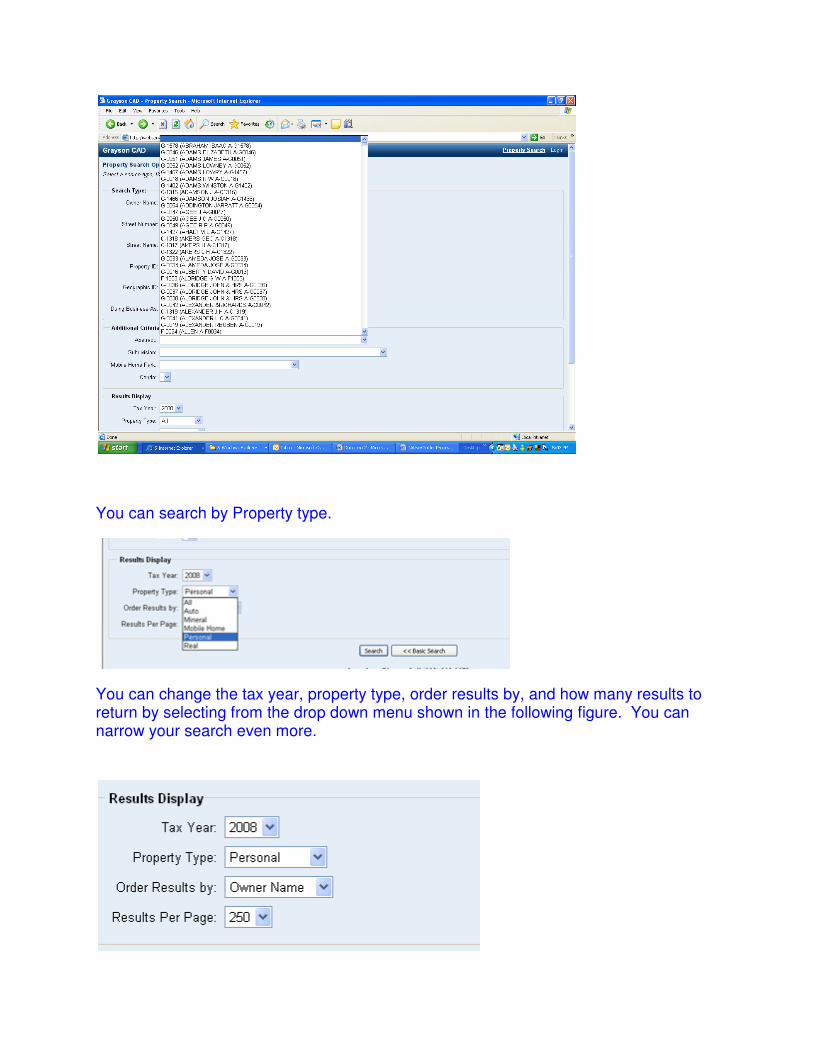
You can search by Property type.
You can change the tax year, property type, order results by, and how many results to return by selecting from the drop down menu shown in the following figure. You can narrow your search even more.

In the example shown in the next figure, we are searching for the following parameters:
• Owner Name > Max
• Tax Year > 2005
• Property Type > Real
• Order Results by > Owner Name
• Results Per Page > 250
Short Options – Use these fields to better locate your target parcel
Example: Sorting by legal description will arrange the search results in lot & block
order sorting by name will show you who has multiple parcels.


To view your property once you have found it you can hit View Details to see all the information on this
property.
Your results viewing area will look like this as a default. In order to see all the data for the property click
on the button expand all or you can click on each tab in order to expand each item. Example click on the
tab called Values this will expand only that area.

If you want to look for another property you can click the link Property Search to start a new search.

INSTRUCTIONS FOR DOWNLOADING
MAPS AND VIEWER SOFTWARE
FOLLOW STEPS
Step 02: Click on the Map Export download link. You will be prompted to either download and
save file or open from its location. You must save it to your disk. Failure to do so could result in a corrupt install if your connection to the Internet is broken
Step 01: Click on the Arc Explore that you would wish to download.
Hint Vista Viewers: you must download Arc Explore 9.1 in order to work in your operating system. If you wish to download the software directly from ESRI or other Free Programs you can go to http://www.esri.com/software/arcexplorer/download.html or http://www.esri.com/software/arcgis/explorer/index.html where you can obtain other free software.
. Step 03: Create a folder called Shapes in your local Disk C:\Shapes
Step 04: Once Map Export is saved to your hard drive double-click on it and select “Extract” and
extract the files to C:\Shapes. Step 05: Once you have completed these actions go to your programs menu:
• ArcExplorer 2.0 instructions: o Once you have completed these actions go to your programs menu,
click ESRI, ArcExplorer 2.0, and then click on ArcExplorer. • ArcExplorer 9.x instructions:
o Once you have completed these actions go to your programs menu,
click ArcGis, ArcExplorer 9.x and then click on ArcExplorer. Step 05a: ArcExplorer 2.0: Select file and open project: ArcExplorer 2.0 have an .aep extension. Step 05b: ArcExplorer 9.x: Select file and open project: ArcExplorer 9.x have an .axl extension. Step 06: Change the directory to C:\Shapes and double-click on the correct map for your software.
• ArcExplorer 2.0 map document choose: Grayson Maps.aep • ArcExplorer 9.x map document choose: Grayson Project.axl
Step 07: You should be up and running now.