Embed Size (px)
Citation preview

Level 2, 38 Richardson Street, West Perth, WA 6005 PO Box 396, West Perth, WA, 6872 Ph. +61 8 9322 6283 Fax. +61 8 9322 6398
www.dempseyminerals.com.au
ACN 149 349 646
ASX ANNOUNCEMENT 15 June 2018
GRAVITY SURVEY RESULTS SUPPORT GREAT POTENTIAL AT
HOMBRE MUERTO
Gravity survey completed for 15km along the length of the Candelas lithium brine project, Hombre Muerto salar, Argentina
Deep basin-channel environment interpreted to depths of up to 600m
Results in line with CSAMT survey confirming excellent potential for presence of a substantial amount of brine
The Hombre Muerto Basin is one of the most globally prolific salt flats, hosting one of the lowest content levels of impurities in the industry
Project is adjacent to Galaxy Resources’ Sal de Vida project and FMC’s Fenix lithium operations (in operation since 1997)
---------------------------------------------------------------------------------------------------------------------------
Dempsey Minerals Limited (ASX:DMI) (Dempsey or the Company) is pleased to announce the results from a Gravity survey recently conducted over the company’s Candelas leases at its Hombre Muerto Lithium Project (the Project) located in Catamarca Province, Argentina. In summary, the interpreted data presented a good model and, as independent geophysical consultants Quantec Geoscience Ltd (Quantec) state in their conclusions; “The salar shows negative contrast values, indicating that the area contains materials of lower density compatible with a basin filled with sediments and a high proportion of fluids” and that “…that the basin could be deep since no high density materials seem to appear to depths of up to 600m, which is congruent with the CSAMT survey”. THE SURVEY The survey was conducted in conjunction with a CSAMT resistivity survey the results of which were reported to the ASX on June 6, 2018. The objectives of the surveys were to define the geometry and depths to basement of the salar and Los Patos channel and to map resistivity contrasts to assist in identifying lithium-bearing brine aquifers. The surveys were conducted and interpreted by highly credentialed geophysical consultants Quantec. Quantec has significant experience in this type of exploration targeting lithium brine mineralisation and has previously conducted work at the neighbouring Sal de Vida project for Galaxy Resources Ltd.
For
per
sona
l use
onl
y
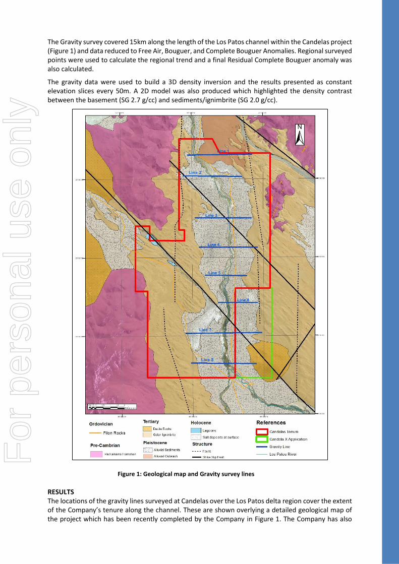
The Gravity survey covered 15km along the length of the Los Patos channel within the Candelas project (Figure 1) and data reduced to Free Air, Bouguer, and Complete Bouguer Anomalies. Regional surveyed points were used to calculate the regional trend and a final Residual Complete Bouguer anomaly was also calculated.
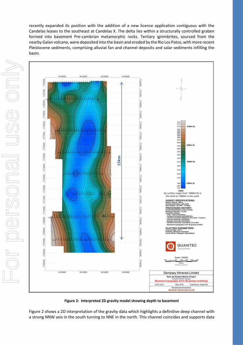
The gravity data were used to build a 3D density inversion and the results presented as constant elevation slices every 50m. A 2D model was also produced which highlighted the density contrast between the basement (SG 2.7 g/cc) and sediments/ignimbrite (SG 2.0 g/cc).
RESULTS The locations of the gravity lines surveyed at Candelas over the Los Patos delta region cover the extent of the Company’s tenure along the channel. These are shown overlying a detailed geological map of the project which has been recently completed by the Company in Figure 1. The Company has also
Figure 1: Geological map and Gravity survey lines
For
per
sona
l use
onl
y
recently expanded its position with the addition of a new licence application contiguous with the Candelas leases to the southeast at Candelas X. The delta lies within a structurally controlled graben formed into basement Pre-cambrian metamorphic rocks. Tertiary ignimbrites, sourced from the nearby Galan volcano, were deposited into the basin and eroded by the Rio Los Patos, with more recent Pleistocene sediments, comprising alluvial fan and channel deposits and salar sediments infilling the basin.
Figure 2: Interpreted 2D gravity model showing depth to basement Figure 2 shows a 2D interpretation of the gravity data which highlights a definitive deep channel with a strong NNW axis in the south turning to NNE in the north. This channel coincides and supports data
nb; surface ranges from ~4000m RL in the north to ~4060m in the south
3700m RL
3500m RL
3300m RL
3400m RL
15
km
For
per
sona
l use
onl
y
collected from the CSAMT survey which showed highly conductive units within the channel compatible with units being saturated with brine.
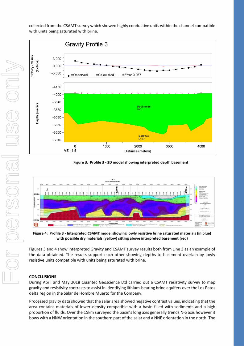
Figure 3: Profile 3 - 2D model showing interpreted depth basement
Figure 4: Profile 3 - Interpreted CSAMT model showing lowly resistive brine saturated materials (in blue)
with possible dry materials (yellow) sitting above interpreted basement (red)
Figures 3 and 4 show interpreted Gravity and CSAMT survey results both from Line 3 as an example of the data obtained. The results support each other showing depths to basement overlain by lowly resistive units compatible with units being saturated with brine. CONCLUSIONS During April and May 2018 Quantec Geoscience Ltd carried out a CSAMT resistivity survey to map gravity and resistivity contrasts to assist in identifying lithium-bearing brine aquifers over the Los Patos delta region in the Salar de Hombre Muerto for the Company.
Processed gravity data showed that the salar area showed negative contrast values, indicating that the area contains materials of lower density compatible with a basin filled with sediments and a high proportion of fluids. Over the 15km surveyed the basin’s long axis generally trends N-S axis however it bows with a NNW orientation in the southern part of the salar and a NNE orientation in the north. The
0m
4000
m
2000
m
3300m
4050m
For
per
sona
l use
onl
y

depths to metamorphic basement may be up to ~600 metres based upon the smooth density contrast inversions and depths to higher density materials.
The CSAMT survey found the Candelas project area to be very conductive and confirmed the presence of shallow units within this basin that are compatible with units being saturated with brine. The brine bearing units appear to be largely alluvial channel fill and possible ignimbrite at depth. Depths to brine are relatively shallow and conductive units, interpreted to be brine material, range from approximately 150 to 400m+ in thicknesses over at least ten kilometres along the delta.
The Company will look to extend the geophysical coverage given that the CSAMT lines show open conductivity anomalies (especially to the west) and that further gravity information over the ignimbrite and basement units is required to the west and east. This will allow for more detailed modelling and a better understanding of the subsurface geology of the project area.
Additionally, the Company has commenced its permitting procedures to conduct drilling over the project as soon as practicable and looks forward to further advancing the project.
Commenting on the survey results, Dempsey’s Chairman, Mr Nathan McMahon, said, “These results have exceeded our initial expectations for the project and give further evidence that the Los Patos channel at Hombre Muerto has the very real potential to host geological units saturated with a substantial amount of brine. Given the projects location in the premiere and only long term proven, producing lithium brine basin in Argentina then we have an exciting time ahead of us. We look forward to progressing the project as quickly as we can.” For further information contact:
Juan Pablo (“JP”) Vargas de la Vega General Manager, Dempsey Minerals Email: [email protected] Tel: +61 8 9322 6283
Nathan McMahon Non-Executive Chairman, Dempsey Minerals Email: [email protected] Tel: +61 8 9322 6283
Media
David Tasker Chapter One Advisors E: [email protected] Tel: +61 433 112 936
Colin Jacoby Chapter One Advisors E: [email protected] Tel: +61 439 980 359
Competent Persons Statement The information contained herein that relates to Exploration Results is based on information compiled or reviewed by Dr Luke Milan, who has consulted to the Company. Dr Milan is a Member of the Australasian Institute of Mining and Metallurgy and has sufficient experience which is relevant to the style of mineralisation and types of deposit under consideration and to the activity which they are undertaking to qualify as a Competent Persons as defined in the 2012 Edition of the ‘Australasian Code for Reporting of Exploration Results, Mineral Resources and Ore Reserves’. Dr Milan consents to the inclusion of his name in the matters based on the information in the form and context in which it appears.
For
per
sona
l use
onl
y
ANNEXURE 1 JORC Code, 2012 Edition – Table 1
Section 1 Sampling Techniques and Data
Criteria JORC Code explanation Commentary
Sampling techniques
Nature and quality of sampling (eg cut channels, random chips, or specific specialised industry standard measurement tools appropriate to the minerals under investigation, such as down hole gamma sondes, or handheld XRF instruments, etc). These examples should not be taken as limiting the broad meaning of sampling.
Include reference to measures taken to ensure sample representivity and the appropriate calibration of any measurement tools or systems used.
Aspects of the determination of mineralisation that are Material to the Public Report.
In cases where ‘industry standard’ work has been done this would be relatively simple (eg ‘reverse circulation drilling was used to obtain 1 m samples from which 3 kg was pulverised to produce a 30 g charge for fire assay’). In other cases more explanation may be required, such as where there is coarse gold that has inherent sampling problems. Unusual commodities or mineralisation types (eg submarine nodules) may warrant disclosure of detailed information.
Quantec undertook a gravity survey from the 24/04/2018 to 11/05/2018 comprising a total of 8 lines over the Candelas project area
Each line is 1km apart, except for lines, 1- 2 and 2- 3 which are ~750m and 1.5km due to the restrictive nature of the northern extent of the project.
Station intervals of 200m for each line
The gravity meter was a LaCoste & Romberg model G gravity meter unit: G319, with an accuracy to ~0.01mGal
197 stations were used with a total of 223 readings resulting in 26 repeat readings across 23 repeated stations, resulting in 10.1% of stations repeated. The % readings repeated was 10.2%
The maximum repeat error was 0.0279, the mean repeat error is 0.0094 with an RMS error of 0.0173
Free air, Bouger and Terrain corrections were all applied to the data using geosoft gravity processing software.
Drilling techniques
Drill type (eg core, reverse circulation, open-hole hammer, rotary air blast, auger, Bangka, sonic, etc) and details (eg core diameter, triple or standard tube, depth of diamond tails, face-sampling bit or other type, whether core is oriented and if so, by what method, etc).
No drilling conducted
Drill sample recovery
Method of recording and assessing core and chip sample recoveries and results assessed.
Measures taken to maximise sample recovery and ensure representative nature of the samples.
Whether a relationship exists between sample recovery and grade and whether sample bias may have occurred due to preferential loss/gain of fine/coarse material.
No drill samples collected
Logging Whether core and chip samples have been geologically and geotechnically logged to a level of detail to support appropriate Mineral Resource estimation, mining studies and
A Gravity survey was conducted but no logging was undertaken
For
per
sona
l use
onl
y

Criteria JORC Code explanation Commentary
metallurgical studies.
Whether logging is qualitative or quantitative in nature. Core (or costean, channel, etc) photography.
The total length and percentage of the relevant intersections logged.
Sub-sampling techniques and sample preparation
If core, whether cut or sawn and whether quarter, half or all core taken.
If non-core, whether riffled, tube sampled, rotary split, etc and whether sampled wet or dry.
For all sample types, the nature, quality and appropriateness of the sample preparation technique.
Quality control procedures adopted for all sub-sampling stages to maximise representivity of samples.
Measures taken to ensure that the sampling is representative of the in situ material collected, including for instance results for field duplicate/second-half sampling.
Whether sample sizes are appropriate to the grain size of the material being sampled.
No sampling or logging undertaken
Quality of assay data and laboratory tests
The nature, quality and appropriateness of the assaying and laboratory procedures used and whether the technique is considered partial or total.
For geophysical tools, spectrometers, handheld XRF instruments, etc, the parameters used in determining the analysis including instrument make and model, reading times, calibrations factors applied and their derivation, etc.
Nature of quality control procedures adopted (eg standards, blanks, duplicates, external laboratory checks) and whether acceptable levels of accuracy (ie lack of bias) and precision have been established.
No assays carried out for this survey
Quantec Geoscience Ltd has significant experience in this type of exploration targeting lithium brine mineralisation and has previously conducted work at the neighbouring Sal de Vida project
Verification of sampling and assaying
The verification of significant intersections by either independent or alternative company personnel.
The use of twinned holes.
Documentation of primary data, data entry procedures, data verification, data storage (physical and electronic) protocols.
Discuss any adjustment to assay data.
Not applicable for gravity geophysical surveying
Quantec Geoscience Ltd has significant experience in this type of exploration targeting lithium brine mineralisation and has previously conducted work at the neighbouring Sal de Vida project
Location of data points
Accuracy and quality of surveys used to locate drill holes (collar and down-hole surveys), trenches, mine workings and other locations used in Mineral Resource estimation.
Specification of the grid system used.
Quality and adequacy of topographic control.
The survey locations were located using modern Garmin handheld GPS with an accuracy of +/- 5m.
The grid System used by Quantec: POSGAR 94, Argentina Zone 3
Topographic control was obtained by handheld GPS, and the topography was flat with very little relief.
For
per
sona
l use
onl
y

Criteria JORC Code explanation Commentary
Data spacing and distribution
Data spacing for reporting of Exploration Results.
Whether the data spacing and distribution is sufficient to establish the degree of geological and grade continuity appropriate for the Mineral Resource and Ore Reserve estimation procedure(s) and classifications applied.
Whether sample compositing has been applied.
Line spacing was designed to obtain optimum and representative coverage of the subsurface Candelas prospect. Each line is 1km apart, except for lines, 1- 2 and 2- 3 which are ~750m and 1.5km due to the restrictive nature of the northern extent of the project area. The spacing in lines 1-3 were shortened due to obtain more detail in the northern extent of the project. This region has a thick pile of alluvial outwash and to ensure detailed subsurface mapping the line spacing was shortened. The spacing between lines 3-8 was suitable for the targeted subsurface geology.
Orientation of data in relation to geological structure
Whether the orientation of sampling achieves unbiased sampling of possible structures and the extent to which this is known, considering the deposit type.
If the relationship between the drilling orientation and the orientation of key mineralised structures is considered to have introduced a sampling bias, this should be assessed and reported if material.
Survey lines were all conducted orthogonal to the long axis of the Candelas to assist in determining basin architecture.
Sample security
The measures taken to ensure sample security.
Data was recorded, processed and provided by Quantec Geoscience Limited ensuring the data was not manipulated or altered.
Audits or reviews
The results of any audits or reviews of sampling techniques and data.
No audits were applied
Section 2 Reporting of Exploration Results
(Criteria listed in the preceding section also apply to this section.)
Criteria JORC Code explanation Commentary
Mineral tenement and land tenure status
Type, reference name/number, location and ownership including agreements or material issues with third parties such as joint ventures, partnerships, overriding royalties, native title interests, historical sites, wilderness or national park and environmental settings.
The security of the tenure held at the time of reporting along with any known impediments to obtaining a licence to operate in the area.
The Hombre Muerto Lithium Project consists of numerous licences located in Catamarca Province, Argentina. The tenements are owned by Blue Sky Lithium Pty Ltd (‘Blue Sky’). The Company and Blue Sky has executed a Share Sale Agreement whereby Dempsey purchased 100% of the issued share capital of Blue Sky.
Exploration done by other parties
Acknowledgment and appraisal of exploration by other parties.
There has not been any historical exploration over the Candelas licence area
Geology Deposit type, geological setting and style of mineralisation.
The Candelas licence area is located within a structurally controlled basin (graben) and is part of the Hombre Muerto salar. The salar hosts a world-renowned lithium brine deposit. The lithium is sourced locally from weathered
For
per
sona
l use
onl
y

Criteria JORC Code explanation Commentary
and altered felsic ignimbrites and is concentrated in brines hosted within basin fill alluvial
sediments and evaporites. Drill hole Information
A summary of all information material to the understanding of the exploration results including a tabulation of the following information for all Material drill holes: o easting and northing of the drill hole
collar o elevation or RL (Reduced Level –
elevation above sea level in metres) of the drill hole collar
o dip and azimuth of the hole o down hole length and interception
depth o hole length.
If the exclusion of this information is justified on the basis that the information is not Material and this exclusion does not detract from the understanding of the report, the Competent Person should clearly explain why this is the case.
No drilling conducted
Data aggregation methods
In reporting Exploration Results, weighting averaging techniques, maximum and/or minimum grade truncations (eg cutting of high grades) and cut-off grades are usually Material and should be stated.
Where aggregate intercepts incorporate short lengths of high grade results and longer lengths of low grade results, the procedure used for such aggregation should be stated and some typical examples of such aggregations should be shown in detail.
The assumptions used for any reporting of metal equivalent values should be clearly stated.
No data aggregation from geophysical survey
Relationship between mineralisation widths and intercept lengths
These relationships are particularly important in the reporting of Exploration Results.
If the geometry of the mineralisation with respect to the drill hole angle is known, its nature should be reported.
If it is not known and only the down hole lengths are reported, there should be a clear statement to this effect (eg ‘down hole length, true width not known’).
No drilling conducted
Diagrams Appropriate maps and sections (with scales) and tabulations of intercepts should be included for any significant discovery being reported These should include, but not be limited to a plan view of drill hole collar locations and appropriate sectional views.
Refer to Maps, Figures and Diagrams in the document
For
per
sona
l use
onl
y

Criteria JORC Code explanation Commentary
Balanced reporting
Where comprehensive reporting of all Exploration Results is not practicable, representative reporting of both low and high grades and/or widths should be practiced to avoid misleading reporting of Exploration Results.
Not applicable
Other substantive exploration data
Other exploration data, if meaningful and material, should be reported including (but not limited to): geological observations; geophysical survey results; geochemical survey results; bulk samples – size and method of treatment; metallurgical test results; bulk density, groundwater, geotechnical and rock characteristics; potential deleterious or contaminating substances.
All meaningful and material information is reported
Quantec Geoscience Ltd has significant experience in this type of exploration targeting lithium brine mineralization and has previously conducted work at the neighbouring Sal de Vida project
Further work The nature and scale of planned further work (eg tests for lateral extensions or depth extensions or large-scale step-out drilling).
Diagrams clearly highlighting the areas of possible extensions, including the main geological interpretations and future drilling areas, provided this information is not commercially sensitive.
Permitting procedures have commenced to commence drilling over the Project
For
per
sona
l use
onl
y