Embed Size (px)
Citation preview

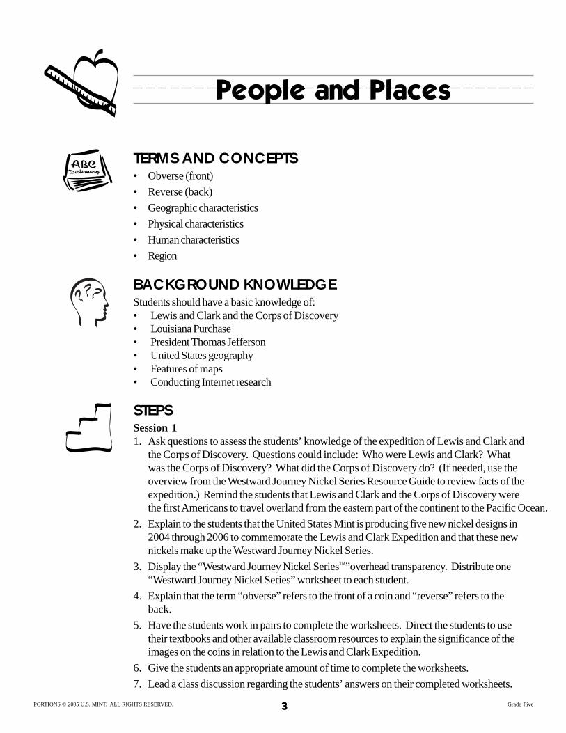
People and PlacesGrade Five
OBJECTIVES Students will understand the influence of geography on human experience, specifically the Lewis and Clark Expedition. Students will describe a place using its physical and human characteristics. Students will understand and apply the basic tools of historical research, including chronology and how to collect, interpret, and use information from primary and secondary sources. Students will create a map.
CLASS TIME Five 45- to 60- minute sessions
NATIONAL STANDARDS This lesson reflects some of the national standards of learning as defined by the National Council for the Social Studies (NCSS), the National Council for Teachers of English (NCTE), the National Council of Teachers of Mathematics (NCTM), and the International Society for Technology in Education (ISTE). These standards are listed below: • Social Studies: Geography
• Social Studies: People, Places, and Environment
• Social Studies: Time, Continuity, and Change
• Language Arts: Students apply a wide range of strategies to comprehend, interpret, evaluate, and appreciate texts. They draw on their prior experience, their interactions with other readers and writers, their knowledge of word meaning and of other texts, their word identification strategies, and their understanding of textual features (e.g., sound-letter correspondence, sentence structure, context, graphics).
• Language Arts: Students conduct research on issues and interests by generating ideas and questions, and by posing problems. They gather, evaluate, and synthesize data from a variety of sources (e.g., print and non-print texts, artifacts, people) to communicate their discoveries in ways that suit their purpose and audience.
• Language Arts: Students use a variety of technological and information resources (e.g., libraries, databases, computer networks, video) to gather and synthesize information and to create and communicate knowledge.
• Language Arts: Students use spoken, written, and visual language to accomplish their own purposes (e.g. for learning, enjoyment, persuasion, and the exchange of information).
• Technology: Research tools—Students use technology to locate, evaluate, and collect information from a variety of sources.
PORTIONS © 2005 U.S. MINT. ALL RIGHTS RESERVED. 1 Grade Five

People and Places
MATERIALS • 1 overhead projector
• Copies of the worksheets attached to this lesson plan (see “Preparations”)
• 1 copy of the Westward Journey Nickel Series™ Resource Guide (available at www.usmint.gov/kids)
• Blank overhead transparencies
• A computer lab with Internet access
• Web sites that include basic information about the Lewis and Clark expedition (see “Prepa-rations”)
• White art butcher paper
• Colored pencils, crayons, or markers
PREPARATIONS • Make copies of the following:
– “Westward Journey Nickel Series™” worksheet (1 per student)
– “Louisiana Territory Map” (from the Resource Guide) (1 per student)
– “Geographic Characteristics” worksheet (1 per student)
– “Characteristics by Region” worksheet (1 per student)
– “Region Map Rubric” (1 per student)
– “Map Research Organizer” (1 per student)
• Make overhead transparencies of the following:
– “Westward Journey Nickel Series” worksheet
– “Louisiana Territory Map” (from the Resource Guide)
– “Geographic Characteristics” worksheet
– “Region Map Rubric”
• Arrange to use the school computer lab.
• Bookmark Internet sites that provide basic information about Lewis and Clark, such as:
– www.nps.gov/jeff/LewisClark2/HomePage/HomePage.htm
– www.lewis-clark.org/
– www.pbs.org/lewisandclark/
– www.nationalgeographic.com/lewisandclark/
GROUPINGS • Whole group
• Pairs
• Independent work PORTIONS © 2005 U.S. MINT. ALL RIGHTS RESERVED. 2 Grade Five
People and Places
TERMS AND CONCEPTS • Obverse (front)
• Reverse (back)
• Geographic characteristics
• Physical characteristics
• Human characteristics
• Region
BACKGROUND KNOWLEDGE Students should have a basic knowledge of: • Lewis and Clark and the Corps of Discovery • Louisiana Purchase • President Thomas Jefferson • United States geography • Features of maps • Conducting Internet research
STEPS Session 1 1. Ask questions to assess the students’ knowledge of the expedition of Lewis and Clark and
the Corps of Discovery. Questions could include: Who were Lewis and Clark? What was the Corps of Discovery? What did the Corps of Discovery do? (If needed, use the overview from the Westward Journey Nickel Series Resource Guide to review facts of the expedition.) Remind the students that Lewis and Clark and the Corps of Discovery were the first Americans to travel overland from the eastern part of the continent to the Pacific Ocean.
2. Explain to the students that the United States Mint is producing five new nickel designs in 2004 through 2006 to commemorate the Lewis and Clark Expedition and that these new nickels make up the Westward Journey Nickel Series.
3. Display the “Westward Journey Nickel Series™”overhead transparency. Distribute one “Westward Journey Nickel Series” worksheet to each student.
4. Explain that the term “obverse” refers to the front of a coin and “reverse” refers to the back.
5. Have the students work in pairs to complete the worksheets. Direct the students to use their textbooks and other available classroom resources to explain the significance of the images on the coins in relation to the Lewis and Clark Expedition.
6. Give the students an appropriate amount of time to complete the worksheets.
7. Lead a class discussion regarding the students’ answers on their completed worksheets.
PORTIONS © 2005 U.S. MINT. ALL RIGHTS RESERVED. 3 Grade Five

People and Places
Use the students’ responses to create a model “Westward Journey Nickel Series”worksheet on the overhead transparency.
8. Display the “Louisiana Territory Map” overhead transparency. Distribute one “Louisiana Territory Map” to each student. Have the students note the Louisiana Territory’s position in relation to your school’s location.
9. Pair up the students. Ask the students to use their textbooks and other available class-room resources to note the following on their maps:
– The route taken by Lewis and Clark’s Corps of Discovery.
– The modern names of the states through which Lewis and Clark traveled (Illinois, Missouri, Kansas, Nebraska, Iowa, South Dakota, North Dakota, Montana, Idaho, Oregon, and Washington.)
– Five major geographic features that Lewis and Clark may have encountered on their journey.
11. Lead a brief class discussion regarding the students’ answers on their maps. Use the students’ responses to create a model “Louisiana Territory Map” on the overhead trans-parency.
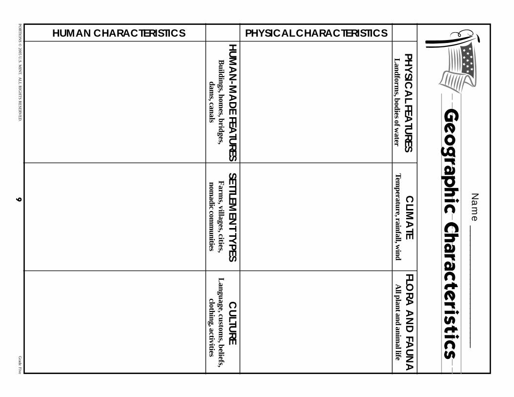
12.Display the “Geographic Characteristics” transparency. Distribute one “Geographic Characteristics” worksheet to each student. Explain to the students that one of the goals that Thomas Jefferson set for the Expedition was to gather information about the geogra-phy of the Louisiana Territory. Explain that geographers use geographic characteristics to define a place or region. Explain that some of these characteristics are physical character-istics and that they include:
– Physical features—landforms and bodies of water
– Weather and climate—temperature, precipitation, and wind
– Vegetation and animals—all plant life and domesticated and wild animals
13.Explain to the students that, in addition to the physical characteristics of a place, geogra-phers also use human characteristics to describe a place. Tell the students that human characteristics are:
– Human-made features—modifications people have made to the land, such as build-ings, homes, bridges, dams, and canals
– Types of settlement—such as farms, villages, cities, and nomadic communities
– Culture—language, customs, beliefs, clothing, and activities of the people
14.Pair up the students. Ask the students to create a list of all of the physical and human characteristics that were likely encountered by the Corps of Discovery. Allow the stu-dents to use their textbooks, completed maps, and other available classroom resources.
15.Allow the students the rest of the class period to work on the worksheet. Direct those who do not complete it to finish it for homework. Collect the “Westward Journey Nickel SeriesTM” worksheet. Remind the students to bring their completed maps and their com-pleted “Geographic Characteristics” worksheets to the next class.
PORTIONS © 2005 U.S. MINT. ALL RIGHTS RESERVED. 4 Grade Five
People and Places
Session 2
1. Have students retrieve their completed maps and their completed “Geographic Character-istics” worksheets. Display the “Geographic Characteristics” overhead transparency. Lead a brief class discussion regarding the students’ answers on their completed worksheets. Use the students’ answers to create a model “Geographic Characteristics” worksheet on the overhead transparency. During the discussion, ask the students to find examples of physical characteristics that affected the human characteristics. Ask the students to explain their answers.
2. Display the “Louisiana Territory Map” overhead transparency. Distribute one “Physical and Human Characteristics by Region” worksheet to each student.
3. Explain to the students that geographers use physical and human characteristics of a place to form regions. Explain to the students that places are categorized as regions when they have one or more common characteristics that give them a measure of unity and make them distinct from surrounding areas. Explain to the students that there are several ways that geographers divide the United States into regions, but for the purposes of this activity, the class will use the following five regions:
– Coastal Plains
– Appalachian
– Great Plains
– Western Mountain
– Pacific
4. Note the approximate boundaries of each region on the overhead transparency of the map. Have the students outline the regions on their maps.
5. Ask the students through which of the regions the Corps of Discovery traveled. Using their maps, the students should see that the Corps traveled through the Great Plains, the Western Mountain, and the Pacific regions.
6 Assign the students to groups of three. Have the students assign the physical and human characteristics from their “Geographic Characteristics” worksheets to the appropriate cell on their “Characteristics by Region” worksheets using their textbooks, their completed maps, and other available classroom resources.
7. Give the students an appropriate amount of time to complete the activity.
8. Lead a brief class discussion regarding the regions in which the physical and human characteristics belong. Discuss which of the characteristics might be the most important in defining each region.
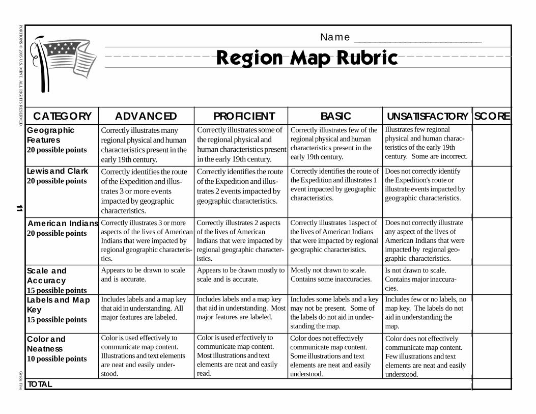
9. Tell the students to select one region from the “Geographic Characteristics” worksheet on which they would like to do an in-depth study. Distribute one “Region Map Rubric” to each student. Discuss the elements of the rubric. Tell the students that they will have the next class period to conduct research. Allow the groups the remainder of the period to plan their activity.
PORTIONS © 2005 U.S. MINT. ALL RIGHTS RESERVED. 5 Grade Five
People and Places
Session 3 1. Escort the students to the computer lab. Distribute one “Map Research Organizer” to
each student. Tell the students that they can begin their research by completing the worksheet and that you have bookmarked Internet sites to help them. Tell the students that, once they have gathered sufficient information, they can begin to plan their maps and that they have the rest of the class period to conduct their research.
2. Circulate among the groups and provide support.
3. Five minutes before the end of class, tell the students that they should finish any necessary research for homework and that they should bring art supplies (colored pencils, markers, rulers, etc.) to the next class.
Session 4
1. Arrange the classroom so that it can accommodate cooperative learning. Place the white art butcher paper, colored pencils, markers, and any other supplies in a common area so that the students have access to them.
2. Display the “Region Map Rubric” overhead transparency. Have the students retrieve their “Region Map Rubric” and their completed “Map Research Organizer.” Briefly review the “Region Map Rubric” with the students. Explain to the students that they will begin working on their maps today and that they will complete and present them during the next class period.
3. Show the students where the supplies are located. Have the students begin working on their maps.
4. Circulate among the groups and provide support.
5. Five minutes before the end of class, direct the students to begin cleaning up. Remind the students they need to bring their “Louisiana Territory Maps,” “Geographic Characteristics” worksheets, “Characteristics by Region” worksheets, and “Map Research Organizers” to the next class session.
Session 5
1. Arrange the classroom so that it can accommodate cooperative learning. Place the white art butcher paper, colored pencils, markers, and any other supplies in a common area so that the students have access to them.
2. Display the “Region Map Rubric” overhead transparency. Have the students retrieve their region maps, their “Region Map Rubrics,” and their completed “Map Research Organiz-ers.” Briefly review the “Region Map Rubric” with the students.
3. Remind the students that they have half the period to complete their region maps and that they will present their region maps to the class during the second half of the class period. Have the students begin working on their maps.
PORTIONS © 2005 U.S. MINT. ALL RIGHTS RESERVED. 6 Grade Five
People and Places
4. Circulate among the groups and provide support.
5. At the appropriate time, direct the students to begin cleaning up. When they are done, have the students present their maps to the class.
6. After each group has presented its map, have the group hang the map in the classroom. Collect each student’s “Louisiana Territory Map,” “Geographic Characteristics” worksheet, “Characteristics by Region” worksheet, and “Map Research Organizer.”
ASSESSMENT • Use student responses on the completed worksheets to evaluate the extent to which the
students met the lesson objectives.
• Use the rubric to evaluate the extent to which the students met the lesson objectives.
ENRICHMENTS/EXTENSIONS • Have students research the Eastern Coastal and the Appalachian regions. Ask students to
discuss how Meriwether Lewis, who was from the Eastern Coastal region, and William Clark, who was from the Appalachian region, would view the other regions. Ask students to hypothesize what they think surprised Lewis and Clark the most.
• Have students view the virtual tour of the expedition’s route at rediscovery.ed.uidaho.edu/ VRTourHome.asp. Ask students to choose one of the images of the landscape from along the route. Have students write a poem from the perspective of one of the members of the Corps of Discovery about the place. The poem should describe how the place looks and the feeling that the person experiences when seeing it.
• Have students follow the route of the Lewis and Clark Expedition using modern maps and other resources to identify the changes that the physical and human characteristics have undergone since the early 19th century.
• Have students use a map and map scale to estimate the number of miles it would take today to follow the Expedition’s route.
DIFFERENTIATED LEARNING OPTIONS • Provide the students with an outline map of each region.
• Provide pictures of the various physical and human characteristics to which students can refer.
• Provide individual or small group support in locating the research information.
PORTIONS © 2005 U.S. MINT. ALL RIGHTS RESERVED. 7 Grade Five

____________________________________________________________
____________________________________________________________
____________________________________________________________
____________________________________________________________
____________________________________________________________
____________________________________________________________
____________________________________________________________
____________________________________________________________
____________________________________________________________
____________________________________________________________
____________________________________________________________
____________________________________________________________
____________________________________________________________
____________________________________________________________
____________________________________________________________
____________________________________________________________
____________________________________________________________
____________________________________________________________
____________________________________________________________
____________________________________________________________
Na
me
_________________________
We
stw
ard
Journ
ey
Nic
ke
l Se
ries
TM
Dire
ctio
ns: The re
verse
s (ba
cks) o
f four o
f the W
estw
ard
Journe
y N
icke
l Serie
sTM nic
kels a
re p
icture
d b
elo
w. Exp
lain the
signific
anc
e o
f the
pic
tures in re
latio
n to the
Co
rps o
f Disc
ove
ry’s journe
y.
PO
RT
ION
S ©
2005 U.S
. MIN
T. AL
L R
IGH
TS
RE
SE
RV
ED
. 8
G
rade Five
Na
me
_________________________
Ge
og
rap
hic
Chara
cte
ristic
s
CLIM
ATE
FLORA
AN
D FA
UN
APH
YSIC
AL FEA
TURES
Temperature, rainfall, w
ind A
ll plant and animal life
Landform
s, bodies of water
HUMAN CHARACTERISTICS PHYSICAL CHARACTERISTICS
HUM
AN
-MA
DE FEA
TURES SETTLEM
ENT TY
PES C
ULTU
RE B
uildings, homes, bridges,
Farm
s, villages, cities, L
angu
age, custom
s, beliefs,
dams, canals
nomadic com
munities
clothing, activities
PO
RT
ION
S ©
2005 U.S
. MIN
T. AL
L R
IGH
TS
RE
SE
RV
ED
. 9
G
rade Five

PO
RT
ION
S ©
2005 U.S
. MIN
T. AL
L R
IGH
TS
RE
SE
RV
ED
. 10
G
rade Five
Name _________________________
Characteristics by Region
PHYSICAL CHARACTERISTICS GREAT PLAINS WESTERN MOUNTAIN PACIFIC COASTALPhysical Features
Climate
Vegetation, Animal Life
HUMAN CHARACTERISTICS GREAT PLAINS WESTERN MOUNTAIN PACIFIC COASTALHuman-Made Features
Settlement Types
Culture
PO
RT
ION
S ©
2005 U.S
. MIN
T. AL
L R
IGH
TS
RE
SE
RV
ED
. 11
Grade F
ive
Name _________________________
Region Map Rubric
CATEGORY ADVANCED PROFICIENT BASIC UNSATISFACTORY SCORE Illustrates few regionalphysical and human charac-
Correctly illustrates few of theCorrectly illustrates some ofGeographic Correctly illustrates manyregional physical and humancharacteristics present in the
the regional physical andFeatures regional physical and humanteristics of the early 19thhuman characteristics present20 possible points characteristics present in thecentury. Some are incorrect.early 19th century. in the early 19th century. early 19th century.
Correctly identifies the route of Does not correctly identifyLewis and Clark Correctly identifies the routeCorrectly identifies the routethe Expedition and illustrates 1 the Expedition's route or20 possible points of the Expedition and illus-of the Expedition and illus-event impacted by geographic illustrate events impacted bytrates 2 events impacted bytrates 3 or more eventscharacteristics. geographic characteristics.geographic characteristics.
characteristics.impacted by geographic
Does not correctly illustrateCorrectly illustrates 1aspect ofCorrectly illustrates 3 or more Correctly illustrates 2 aspectsAmerican Indiansany aspect of the lives ofthe lives of American Indiansaspects of the lives of American of the lives of American20 possible pointsAmerican Indians that werethat were impacted by regionalIndians that were impacted by Indians that were impacted byimpacted by regional geo-geographic characteristics.regional geographic characteris- regional geographic character-graphic characteristics.tics. istics.
Appears to be drawn to scaleand is accurate.
Includes labels and a map keythat aid in understanding. Allmajor features are labeled.
Color is used effectively tocommunicate map content.Illustrations and text elementsare neat and easily under-stood.
Appears to be drawn mostly toscale and is accurate.
Includes labels and a map keythat aid in understanding. Mostmajor features are labeled.
Color is used effectively tocommunicate map content.Most illustrations and textelements are neat and easilyread.
Mostly not drawn to scale.Contains some inaccuracies.
Includes some labels and a keymay not be present. Some ofthe labels do not aid in under-standing the map.
Color does not effectivelycommunicate map content.Some illustrations and textelements are neat and easilyunderstood.
Scale andAccuracy15 possible pointsLabels and MapKey15 possible points
Color andNeatness10 possible points
TOTAL
Is not drawn to scale.Contains major inaccura-cies.
Includes few or no labels, nomap key. The labels do notaid in understanding themap.
Color does not effectivelycommunicate map content.Few illustrations and textelements are neat and easilyunderstood.
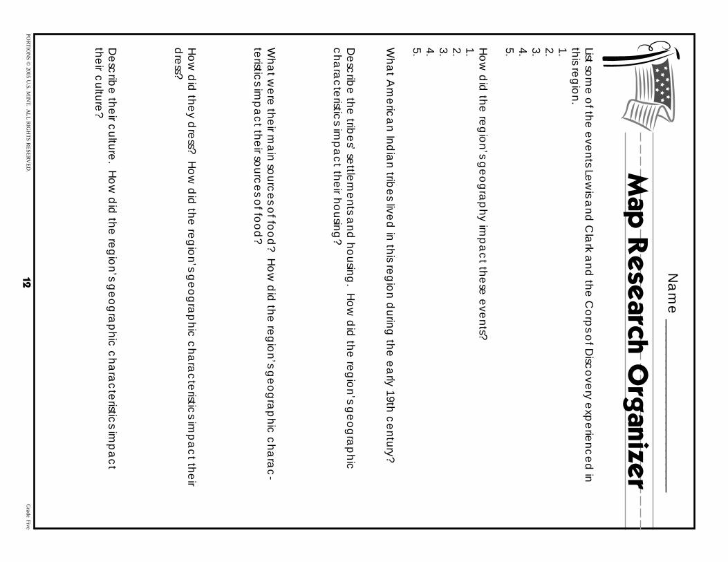
Na
me
_________________________
Map
Re
se
arc
h O
rganiz
er
List som
e o
f the e
vents Le
wis a
nd C
lark a
nd the
Co
rps o
f Disc
ove
ry exp
erie
nce
d in
this reg
ion.
1. 2. 3. 4. 5.
Ho
w d
id the
reg
ion’s g
eo
gra
phy im
pa
ct the
se e
vents?
1. 2. 3. 4. 5.
Wha
t Am
eric
an Ind
ian trib
es live
d in this re
gio
n during
the e
arly 19th c
entury?
De
scrib
e the
tribe
s’ settle
me
nts and
housing
. Ho
w d
id the
reg
ion’s g
eo
gra
phic
c
hara
cte
ristics im
pa
ct the
ir housing
?
Wha
t we
re the
ir ma
in sourc
es o
f foo
d? H
ow
did
the re
gio
n’s ge
og
rap
hic c
hara
c-
teristic
s imp
ac
t their so
urce
s of fo
od
?
Ho
w d
id the
y dre
ss? Ho
w d
id the
reg
ion’s g
eo
gra
phic
cha
rac
teristic
s imp
ac
t their
dre
ss?
De
scrib
e the
ir culture
. Ho
w d
id the
reg
ion’s g
eo
gra
phic
cha
rac
teristic
s imp
ac
t the
ir culture
?
PO
RT
ION
S ©
2005 U.S
. MIN
T. AL
L R
IGH
TS
RE
SE
RV
ED
. 12
G
rade Five