Embed Size (px)
Citation preview

Organisation of Eastern Caribbean States [OECS] Project and
United States Agency for International Aid-Caribbean Open Trade Support [USAID-COTS] Program
Government of Saint Lucia Risk Management Benchmarking Tool
Saint Lucia National Emergency Management Plan Modelled upon Project Documents
Rev. 17 & 27 September 2007 | 6 October 2007
On 18th May by Conclusion 497 of 2009 The Cabinet of Ministers approved the Benchmarking Tool and Assessment

Page 2 of 59

Page 3 of 59
RRiisskk MMaannaaggeemmeenntt BBeenncchhmmaarrkkiinngg TTooooll
Prepared for Environment and Sustainable Development Unit (ESDU)
Organisation of Eastern Caribbean States Morne Fortune, Castries, Saint Lucia
and United States Agency for International Development
Caribbean Open Trade Support Program Gambles Medical Centre, ANTIGUA, W.I.
Prepared by Jacob Opadeyi, PhD and Balfour Spence, PhD
The University of the West Indies West Indies
July 2007
The author’s views expressed in this publication do not necessarily reflect the views of the United States Agency for International Development or the United States Government.

Page 4 of 59
RISK MANAGEMENT BENCHMARKING TOOL
Acronyms and Abbreviations CBO Community Based Organizations CDB Caribbean Development Bank CDERA Caribbean Disaster Emergency Response Agency CDM Comprehensive Disaster Management CRMI Caribbean Risk Management Initiative CDMP Caribbean Disaster Mitigation Project CRDR Caribbean Reducing Disaster Risk report DMFC Disaster Mitigation Facility for the Caribbean DRMBT Risk Management Benchmarking Tool GIS Geographic Information Systems IADB Inter-American Development Bank IDEA Instituto de Estudios Ambientales MOU Memorandum of Understanding MVAT Model Vulnerability Assessment Tool NDMO National Disaster Management Organizations NEOC National Emergency Operations Centre NGO Non- Government Organizations OAS Organization of American States OECS Organization of Eastern Caribbean States SOP Standard Operating Procedures UNC Universidad Nacional de Colombia-Sede Manizales, UNDP United Nations Development Programme USAID United States Agency for International Development

Page 5 of 59
RISK MANAGEMENT BENCHMARKING TOOL PREFACE The Caribbean is particularly vulnerable to natural hazards such as hurricanes, earthquakes, volcanoes, flooding. In order to achieve sustained growth, the public and private sectors in the region must formulate and implement meaningful actions to measurably reduce the region’s risk profile for such natural disasters. The approach to disaster risk reduction in the region is varied. In some cases, national policies and plans exist, but lack resources for implementation. In other cases, national policies and plans are not in place, and there are no overarching frameworks to address disaster preparedness and mitigation. Generally, the technical analysis regarding the region’s risks and the appropriate solutions has already been undertaken. However, a specific action agenda that is directed to achieving a measurable reduction in the region’s risk profile for natural disasters has largely been missing. The Caribbean Open Trade Support Program (COTS), funded by the United States Agency for International Development (USAID), is designed to help facilitate the transition of countries in the Eastern Caribbean from traditional trading regimes to open trade and to enable them to compete more successfully and sustainably in the global economy. Working with the Organization of Eastern Caribbean States (OECS) Secretariat, national institutions and other organizations, the USAID-funded COTS team is therefore designing a series of activities to improve the ability of national governments, civil society organizations, and the private sector to proactively plan and implement actions to reduce vulnerability to natural disasters and create greater economic resilience when they do occur. COTS will focus on the following activities to help reduce the region’s vulnerability to natural hazards: • Assisting the OECS Secretariat and selected national governments to develop and utilize a methodology for identifying and prioritizing risk reduction actions and for quantifying reductions in the risk profile. • Working directly with businesses and related associations to enable businesses to become more resilient to the impact of natural disasters. • Assisting in the development of market-based incentives for risk reduction activities, e.g., through the insurance and financial sectors. • Supporting the development of a vulnerability tool to be used throughout the region to assist countries to assess their vulnerability to natural and man induced disasters. • Assisting selected countries in the implementation of their risk reduction action agenda by strengthening elements of their legislative and institutional frameworks, and implementing actions that result in a measurable reduction of the countries’ exposure to natural disasters. Public awareness and outreach are a key component of this strategy, ensuring that needed information is readily available to the public and private sectors and NGOs. At the end of the four-year project, COTS expects to see: • Effective legislative and institutional frameworks in place for risk reduction in the face of natural disasters, in accordance with regional models. • Sustainable and diversified economic growth that is more resilient to the impact of natural hazards. • Approaches to risk reduction that is fully integrated with other cross-cutting policies and interventions (e.g., coastal zone management, climate change, biodiversity, forest management). • Measurable reduction in the assisted countries’ risk profile for natural disasters. The authors, Drs. Jacob Opadeyi and Balfour Spence do appreciate the contributions of all persons and institutions who provided feedback and suggestions that helped to improve this document.

Page 6 of 59
1.0 RISK MANAGEMENT BENCHMARKING TOOL The goal of developing a regional Risk Management Benchmarking Tool (BTool) is to improve the ability of national governments, civil society organizations, and the private sector to proactively plan and implement effective and efficient actions that would reduce their vulnerability to natural disasters and create greater economic resilience when they do occur. The BTool has the following utilities:
• A tool for evaluating the adequacy of current disaster risk management tools. • A tool for evaluating the readiness and capability of local national institutions to deal with the risk of disaster. • A list of best practice recommendations for disaster risk management. • A tool for regional benchmarking of nations and programmes.
The following are the design considerations adopted for the Benchmarking Tool. The tool should be:
• comprehensive in scope • non-technical in content • simple to implement • verifiable and replicable • transparent and representative • objective and positive in tone • definite and absolute
Membership The Technical Working Group (TWG) for Risk Assessments is a working group of the National Hazard Mitigation Council. The membership includes but is not confined to the following:
1. Ministry of Finance [CHAIR] 2. Ministry of Physical Development [DEPUTY CHAIR] 3. Saint Lucia Met Services 4. Saint Lucia Red Cross 5. Saint Lucia Insurance Council 6. Saint Lucia Hotel and Tourism Association 7. Ministry of Agriculture Forestry and Fisheries 8. Ministry of Education 9. Ministry of Social Transformation 10. Ministry of Works 11. Rep – Financial Intuitions 12. Solid Waste Management Authority 13. NEMO – Damage Assessment Committee Ex Officio 14. NEMO Secretariat
The Benchmarking Tool is designed as a self-administered tool with responsibility for oversight, data analyses, data storage, data management, and quality control assigned to an independent regional lead agency. It is not intended, at this time, to be comprehensive given the following multi-dimensions of disaster risk management: risk exposure, geographic extent, and vulnerable elements. In terms of risk exposure, it was designed for multi-hazards with the scope to rework it for a particular hazard. In geographic extent, it could be redesigned for use at national, community, or enterprise levels. It is, however, customizable to meet specific dimensions. In its present form, it covers all the

Page 7 of 59
vulnerable elements in general but may be redesigned to focus on any one of the following vulnerable elem ents: affected population, infrastructure, economy, and environment. The benchmarking tool provides the following benefits to the region as a whole:
• It provides a snapshot of a country’s exposure to natural disaster. • It can be used to build support for the allocation of resources to reduce risk in areas defined by the BT ool. • It can be used to prioritize national and regional programmes of activities. • It can be used as an incentive at the political level to stimulate action due to the comparative nature of its
scores against another country. • It provides information, in a consistent manner, on the state of readiness of each country. This information
can be used by regional and international funding agencies to define or redefine programmes of assistance to the region.
The tool was developed in six stages. These are:
• Selection of a comprehensive disaster management framework • Identification of disaster risk management tools and resources • Design of assessment questions • Stakeholder review and modification of the tool • Pilot testing and modification of the tool • Adaptation of the tool by local and regional stakeholders.
Stage 1: Selection of a comprehensive disaster management framework After an extensive literature review, the following six (6) components of key disaster risk management activities were adopted: hazard identification, hazard mitigation, risk transfer, disaster preparedness, emergency response, and recovery as provided in Table 1 (IADB, 2000).
Table I: Key Components of Risk Management Source: Inter-American Development Bank, 2000, “Facing the Challenge of Natural Disasters in Latin America and the
Caribbean: an IDB Action Plan.”
Pre-Disaster Phase Post-Disaster Phase A. Risk
Identification B. Risk
Mitigation C. Risk Transfer D. Disaster
Preparedness E. Emergency
Response F. Rehabilitation
and reconstruction
1. Hazard assessment (frequency, magnitude, and location)
1. Physical and engineering mitigation works
1. Insurance and reinsurance of public infrastructure and private assets
1. Early warning and communication systems
1. Humanitarian assistance
1. Rehabilitation and reconstruction of damaged infrastructure
2. Vulnerability assessment (population and assets exposed)
2. Land-use planning and building codes
2. Financial market instruments (catastrophe bonds and weather-indexed hedge funds)
2. Contingency planning (utility companies and public services)
2. Clean-up, temporary repairs, and restoration of services
2. Macroeconomic and budget management (stabilization and protection of social expenditures)
3. Risk assessment (a function of
3. Economic incentives for pro-mitigation
3. Privatization of public services with safety
3. Networks of emergency responders (local
3. Damage assessment
3. Revitalization for affected sectors (exports,

Page 8 of 59
hazard and vulnerability)
behavior regulation (energy, water and transportation)
and national) tourism, and agriculture)
4. Hazard monitoring and forecasting (mapping, and scenario building)
4. Education, training and awareness about risks and prevention
4. Calamity Funds (national or local level)
4. Shelter facilities and evacuation plans
4. Mobilization of recovery resources (public, multilateral, and insurance)
4. Incorporation of disaster mitigation components in reconstruction activities
Stage 2: Identification of disaster risk management tools and resources The next stage in the design process is the selection of tools and resources required to effectively and efficiently manage the six components of disaster risk management activities listed above. The following are the tools and resources that were selected for review:
• Policies and plans • Regulations and legislation • Human resources • Financial resources • Technical resources • Public education and awareness • Infrastructure development
• Administrative arrangements • Inter-agency Coordination • Integration of plans and activities • Involvement of the resident community • Involvement of the private sector • Involvement of the regional & international
agencies Stage 3: Design of risk management assessment questions Stage three involves the formulation of a series of management questions that aim to explore the adequacy and content of current disaster risk management tools and resources of the country in each of the six disaster management phases and the design of a scoring system. The questions were phrased to highlight best practices recommendations in disaster risk management activities. It contains a list of easily understood questions that were chosen through extensive review of risk management literature and broad-based consultation. The questions were aimed to solicit three forms of responses: a definite “YES”, a definite “NO”, and a “PLANNED” response. Where the response is “NO” or “planned”, the respondents are encouraged to provide short comments that will help in understanding the country’s position on a particular question. A score of three (3) would be assigned for a “YES” response, zero (0) to a ‘NO” response, and one (1) for a “PLANNED” response. Where a question is not applicable to the situation of a country, “NA” should be returned as a response. Stage 4: Stakeholder review and modification of the BTool In stage four (4), the draft BTool was sent for review to regional and international practitioners and specialists in disaster risk management. Very useful feedback was received leading to the production of several updates of the BTool. All of the feedback received helped in improving the BTool. Stage 5: Workshop on the use of the BTool At the end of the regional and international reviews, national stakeholders’ reviews were held in three Caribbean States: Antigua and Barbuda, Dominica, and St. Vincent and the Grenadines. A series of technical and policy level workshops were held in September 2006 in these selected countries. One of the objectives of these workshops was

Page 9 of 59
to have the BTool reviewed by a broader range of implementers at national levels so as to test the appropriateness of the product and to determine how best to have it adopted in the region. Workshop participants provided valuable comments and suggestions. These were incorporated into the BTool, thus improving the assessment questions and tool in general. In general, there was overwhelming support for the use of the BTool as a national and regional benchmarking tool. Implementers also expressed the need to adapt the BTool as a disaster risk management tool for communities and industry. It was felt that a similar but specific BTool should be developed for other social and economic entities, such as hospitals, airports, and utilities, so as to ensure that risk reduction mechanisms of these enterprises are monitored, and, where, necessary, strengthened. Stage 6: Adoption of the tool by local, national, and regional stakeholders After the series of review, the next stage is the adoption of the tool by national and regional stakeholders. Participants at the workshops suggested the following action plans toward the adoption of the BTool:
1. Provide sufficient financial and technical resources by national governments to fulfill the objectives of the BTool; that is, reducing the region’s risk exposure to natural hazard events.
2. Establish a National Risk Reduction Committee in each country that has the responsibility to implement the
BTool, and present the results of each country’s readiness to withstand natural hazards.
3. Build the knowledge-base of political directorates, Permanent Secretaries, and Chief Executive Officers of major public and private agencies on the utility of the BTool as a self-assessment disaster risk management evaluation tool.
4. Formulate policy directives and legislative support towards the mainstreaming of the BTool as an annual
audit tool to be implemented by all key agencies of a country.
5. Build effective public awareness programme that promote stakeholder participation and involvement in the use and adaptation of the BTool
6. Establish and fund an award programme that recognizes and rewards progress made by stakeholders
towards meeting the disaster risk reduction agendas of enterprises, communities, and the nation.
7. Identify and nominate a national champion that will promote the use of the BTool.

Page 10 of 59
2.0 USING THE RRIISSKK MMAANNAAGGEEMMEENNTT BBEENNCCHHMM AARRKKIINNGG TTOOOOLL The BTool may be used as both a national assessment tool as well as a regional disaster risk benchmarking tool if implemented among groups of countries in a region.. 2.1 National Assessment As a national assessment tool, it is recommended that a national multi-sector assessment team be established. The team should comprise of persons from the public sectors, business community, and community-based organizations. The work of the team should be supported by a research assistant who will be responsible for the sourcing of relevant documents, data, and information required to accurately respond to the assessment questions. If necessary, the team should be divided into six sub-teams, with each sub-team focusing on one of the six disaster risk management components: risk identification, risk mitigation, risk transfer, disaster preparedness, emergency response, and rehabilitation and reconstruc tion. The team will score the adequacy of the country’s risk management tools and resources and return an agreed score for each of the six components of disaster risk management. 2.2 Scoring Responses to the Questions In section AO (Hazard Identification), simply respond Yes or No to the questions posed and feel free to write appropriate comments in the remarks column. If the space provided in the remarks column is not large enough, write the remark in a separate sheet of paper and attach this to the assessment report. For each of the other questions in section A1 through F4, select one of four types of responses that best describes the current status of disaster risk management of the country. The four optional responses are “YES”; “Qualified Yes”; “PLANNED”; and “No”.
Response Description Score to be awarded
Yes Means that the country has an absolute positive response to the question posed. 3 Qualified Yes
Means the country has a conditional positive response and the condition that prevented an absolute response should be clearly stated in the remarks column e.g. outdated laws; inadequate funding
2
PLANNED Means the country has initiated action towards providing a positive response within the next 2 years. In the remark column, a statement on the status of the plan should be provided.
1
No Means the country has a negative response to the question posed. 0 A score of three (3) would be assigned for a “YES” response, two (2) for “Qualified Yes” response ; one (1) for “Planned” response and zero (0) to a ‘NO” response,. 2.3 Computing the National I ndices A two-step approach is proposed for the rating of a country’s disaster risk management efforts. In the first step, the risk management index (RMI) for each of the six components of comprehensive disaster risk management (CDRM) is calculated. In the second step, the Total Disaster Risk Management Index (TDRMI) of the country is computed.

Page 11 of 59
Step 1: Calculating the Risk management Index (RMI) for particular component of the Comprehensive Disaster Risk Management (CDRM)
RMI i = [TSi / MAS i] ............. (a) TSi is the total scored in a particular component of CDRM ; MASI is the maximum attainable score for that particular component of CDRM ; and TNQ is the total number of applicable questions posed that particular component of CDRM.
TSi = ( [ No. of YES responses x 3 ] + [ No. of Qualified Yes responses x 2 ]+ [ No. of PLANNED responses x 1 ] ) ........ (b)
MASi = [TNQ i x 3] .......... (c)
For the component Risk Mitigation (RM) therefore:
RMIRM = [TSRM / MASRM]; TSRM = ( [ No. of YES responses x 3 ] +
[ No. of Qualified Yes responses x 2 ]+ [ No. of PLANNED responses x 1 ] )
and MASRM = [TNQRM x 3]
Example If country A has the following raw score for each of the components of CDRM:
Phases of Risk Management Total No. of Questions (TNQi)
Number of Yes
responses
Number of Qualified Yes
responses
Number of Planned
responses 1. Risk Identification Index 106 53 10 12 2. Risk Mitigation Index 62 14 6 21 3. Risk Transfer Index 48 28 7 9 4. Disaster Preparedness Index 123 75 15 5 5. Emergency Response Index 56 16 5 12 6. Rehabilitation and Reconstruction Index 56 12 10 19
Total 451 198 53 78 The TSi and RMIi for each of the six components would be as follows:
Phases of Risk Management Total No. of Questions (TNQi)
(MASI) Total Score (TS i) RMI i
1. Risk Identification Index 106 318 53x3 + 10 x 2 + 12=191 60% 2. Risk Mitigation Index 62 186 14x3 + 6 x 2 + 21=75 40% 3. Risk Transfer Index 48 144 28x3 + 7 x 2 + 9=107 74% 4. Disaster Preparedness Index 123 369 75x3 + 15 x 2 + 5=260 70% 5. Emergency Response Index 56 168 16x3 + 5 x 2 + 12=70 42% 6. Rehabilitation and Reconstruction Index 56 168 12x3 + 10 x 2 + 19=75 45%
Total 451 1353 778 55%

Page 12 of 59
Step 2: Calculating the Total Disaster Risk Management Index (TDRMI) The Total Disaster Risk Management Index (TDRMI) of a country is the average of its score in each of the six components of comprehensive risk management. This is computed as: TDRMI = S[RMIRI, RMIRM, RMIRT, RMIDP, RMIER, RMIRR] X 1/6 Using these indices, the country is able to identify the adequacy of its risk management initiatives, identify gaps, overlaps, omissions, as well as strengths and successes. The indices may be used to select and prioritize projects and programmes that will help to improve its future rankings. The result of this assessment may also be used to develop remedial actions, programs of work, and build support for budgetary allocations in the following years after the assessment. The effectiveness of corrective actions taken may be evaluated by comparing the TDRMI of one year against another by posing the question:
Is TDRMI2007 > TDRMI2006 ? 2.4 The Use of the BTool as a Regional Benchmarking Tool The BTool may also be used as a regional benchmarking tool for comparing the level of disaster risk management of one country against another. In order to do this, the indices of each of the countries in the six components of comprehensive disaster risk management should be recorded as well as their Total Disaster Risk Management Index (TDRMI). A ranking of countries based on their indices in each of the phases of disaster risk management may be produced in order to determine the relative position of each country in the region as well as a regional ranking of the overall Total Disaster Risk Management Index. Such a ranking scheme could be used to promote healthy regional competition for best practice in Disaster Risk Management and provide the opportunity for countries to learn from one another in terms of the sharing of success stories as well as failure stories. The ranking scheme may also be used to design award and recognition programmes for participating States.
Country RMIRI RMIRM RMIRT RMIDP RMIEP RMIRR TDRM Index 1. Anguilla 2. Antigua and Barbuda 3. Bahamas 4. Barbados 5. Belize 6. British Virgin Islands 7. Dominica 8. Grenada 9. Guyana 10. Haiti 11. Jamaica 12. Montserrat 13. Saint Lucia 14. St. Kitts and Nevis 15. St. Vincent and the
Grenadines
16. Suriname 17. Trinidad and Tobago 18. Turks and Caicos Islands
Highest score Lowest score

Page 13 of 59
As a benchmarking tool, the BTool has the following utilities: § It identifies the country that has a higher index in a particular component and thus helps to identify what risk
reduction tools and mechanisms the country has deployed to attain this high index. Other countries may then seek to learn from this country.
§ It identifies countries that scored low indices in a particular component and thus supports in the design of
regional projects to reduce a country’s risk and improve their score in the next year. § If the assessment is done on a annual basis, the RMIs and TDRMIs of a country over a period of years may
provide an indication of whether the country is improving in its disaster risk reduction efforts or not. § It may be used to evaluate the impacts of a disaster risk reduction investment project.
§ It may be used to evaluate the relative strengths and weakness of disaster risk reduction initiatives of a
country. 2.4 Quality Control and Quality Assurance In order to ensure credibility and transparency, a national workshop should be held during which the score awarded by the National Assessment Team is presented for review by stakeholders and feedback is solicited from responsible public and private institutions. The workshop should also be used to build awareness and support for current and planned national programs of work designed to reduce the country’s vulnerability during the next period. An independent regional quality assurance team should be formed with the responsibility for regional ranking, physical verification of responses provided by countries, monitoring the trends in responses provided, and providing training in the use of the Benchmarking Tool across the region.

Page 14 of 59
RRiisskk MMaannaaggeemmeenntt BBeenncchhmmaarrkkiinngg TTooooll [BTool]
A. Risk Identification A0. Hazard Identification
Yes No Remarks AO Which of the following hazards are prevalent in your communities? X a. Earthquake hazards X b. Volcanic hazards X Dormant c. Landslide hazards X d. Flood hazards X e. Drought hazards X f. Hurricane wind hazards X g. Storm surge hazards X h. Chemical hazards X
i. Biological e.g. epidemics, agricultural pest X Avian Influenza, Giant African Snail, Leaf Spot Disease
j. Technological X k. Tsunamis X l. Fire X
m. Civil unrest X n. Other (specify) X Oil Spill
Response Yes Qualified Yes No Planned Comments 3 2 0 1
A1. Hazard Mapping and Assessment
1 Have any of the hazards identified above been assessed and areas subject to their effects mapped? X
Have some maps but not all. Planning to do in future.
If YES, answer the following questions. If NO, go to question 2.
1a. Do the hazard maps depict the location and magnitude of hazards? X On the maps that we currently have
1b. Does the hazard map show the vulnerable human settlements in the communities? E.g. homes X

Page 15 of 59
1c. Does the hazard map show the vulnerable social infrastructure in the communities? E.g. parks and other public places X
1d. Does the hazard map show the vulnerable economic infrastructure in the communities? E.g. markets X
1e. Does the hazard assessment consider the influence of human activities? E.g. change in land-use on the impact of hazards X
1f.
Are these maps available in public places such as community centers, places of worship, schools, and police stations within
vulnerable communities? X Available at the Ministry of Planning.
1g. Are these maps produced at scales that permit their use for
development planning and development control? X
1h. Are these maps easily understood by the general public? X Definitely not.
2 Does every household in the communities know the impact zones
of these hazards? X
3 Are the magnitudes, dates and time of the occurrences of past
hazards/disasters officially recorded and stored? X
4 Has the responsibility for the recording and storage of disaster
incidence been officially assigned to an agency? X
5 Have the causes of hazard/disaster impacts been investigated and
remedial options proposed? X
In some cases remedial options are proposed however more for mass causalities
6 Have the reports of these causes and remedies been made
public? X In some cases
7 Has the potential magnitude and frequency of future occurrences
of these hazards been forecasted? X For earthquakes so far
8 Have integrated hazard maps that assess the interaction of
multiple natural hazards been produced? X
9 Do you have a policy that mandates the preparation, publication
and revision of hazard maps for all communities? X
10 Do you have legislation that mandates the preparation, publication
and revision of hazard maps for all communities? X Preparation and revision but not publication
11 Do you have standards and regulations for the preparation,
publication and revision of hazard maps? X 12 Is the methodology scientific? X
13 Is the cost of producing, publishing, distribution and revision of
hazard maps consistently budgeted for? X
14 Has the responsibility for the preparation, publication, distribution
and revision of hazard maps been officially assigned to an X Only for preparation and review but not for distribution and publication

Page 16 of 59
agency?
15 Do local communities, NGOs and other stakeholders participate in
the preparation and revision of hazard maps? X
16 Do local communities, NGOs and other stakeholders participate in
the publication and distribution of hazard maps? X
17 Do you have local technical capacity for the preparation,
publication and revision of hazard maps? X
To date, only one suitably qualified individual, thus there is a lack of human resource capacity
18 Where local technical capacity is limited, do you seek and/or get
support from regional agencies? X
19 Where regional technical capacity is limited, do you seek and/or
get support from international agencies? X
20 Are the products of hazard mapping exercises centrally stored and
accessible to all stakeholders? X
21 Is your country a signatory to conventions on the storage and
disposal of hazardous chemicals? X Signatories to Marine Conventions
22 Are there designated sites for the storage of hazardous
chemicals? X
23
Is there a known designated national agency responsible for regulating the use, storage, transportation and disposal of
hazardous chemicals? X
24 Are there standards and regulations in place for the use, storage,
transportation and disposal of hazardous chemicals? X
25 Do you have national capacity for the implementation of these
standards and regulations? X Do not have the capacity or resources.
26 Have locations of significant oil/fuel spill potential been identified? X
27 Are there 'quick response' measures in place in areas of high oil-
spill potential? X Oil Spill Response Team
28 Are there arrangements for monitoring and evaluating the
effectiveness of hazard mapping and assessment? X TOTAL
29a Please indicate the total number of communities or villages in the
country Too many to know
29b. What is the percentage of communities assessed on the basis of questions 1-28

Page 17 of 59
A2. Vulnerability Assessment
1 Have you conducted vulnerability assessments for all prevalent hazards in your communities? X
If YES, answer the following questions. If NO, go to question 2.
1a.
Does the vulnerability assessment pay special attention to the needs of the following population sectors: women, aged, young, chronic aliment and persons with physical or mental challenges? X
1b. Does the vulnerability assessment pay special attention to physical assets? e.g. bridges X
1c. Does the vulnerability assessment pay special attention to critical facilities e.g. hospitals, power stations? X
1d. Does the assessment include economic analysis? X
1e.
Does the vulnerability assessment pay special attention to bio-geophysical assets, such as coral reefs, protected areas, and other ecologically sensitive sites? X
1f. Does the assessment pay special attention to mass and rapid movement of affected persons? X
Just started need to identify communities
1g. Does the assessment pay special attention to airports, seaports and other transport facilities? X
1h. Are the vulnerability assessments revised on a regular basis? X Ad hoc
1i. Were the vulnerability assessments based on current and accurate data? X
1j. Are the results of the vulnerability assessments quantitative? X Qualitative
1k. Were the vulnerability assessments based on the output from a hazard mapping and assessment? X
2
Do you have a policy that mandates the preparation, publication and revision of vulnerability assessments for all vulnerable communities? X Emphasis on mandate
3
Do you have legislation that mandates the preparation, publication and revision of vulnerability assessments for all vulnerable communities? X Preparation and revision
4 Do you have standards and regulations for the preparation, publication and revision of vulnerable assessments? X No regulations
5 Is the cost of producing, publishing and revision of vulnerability assessments consistently budgeted for? X

Page 18 of 59
6 Has the responsibility for the preparation, publication and revision of vulnerability assessments been assigned to a national entity? X
7 Do you have national capacity for the preparation, publication and revision of vulnerability assessments? X No finance.
8 Are local communities actively involved in the preparation, publication, distribution and revision of vulnerability assessments? X
No revision however preparation and publication
9 Where national capacity is limited, do you seek and/or get support from regional agencies? X
10 Where regional capacity is limited, do you seek and/or get support from international agencies? X
11 Are all stakeholders involved in the assessment process? x
National Stakeholders are involved however community members are not.
12 Are the outputs of the vulnerability assessments made public and shared with all stakeholders? X
For view on the internet. And available upon request
13 Do Government's programmes across all sectors incorporate the results of vulnerability assessments? X In some cases not all sectors
14 Do private sector development plans and activities incorporate the results of vulnerability assessment? X
Some compliance by some companies.
15 Are there arrangements for monitoring and evaluating the effectiveness of vulnerability assessment? X
TOTAL
A3. Risk Assessment
1 Have you assessed the social and cultural assets at risk in all communities? X
2 Have you estimated the number of persons exposed to hazard-related risk? X
Small population, close proximity basically everyone is at risk but may be centered around certain communities depending on hazard.
3 Have you assessed social and economic infrastructure at risk? X some 4 Have you assessed bio-geophysical assets at risk? X Coral reefs, nature reserves 5 Are risk assessments hazard specific? X 6 Are risk assessments community specific? X All communities at risk 7 Are the risk assessments conducted on a regular basis? X 8 Are the risk assessments revised on a regular basis? X Hope to review every five years
9 Do the risk assessments rely on vulnerability assessments and hazard mapping? X Not necessarily hazard maps

Page 19 of 59
10 Are the results of the risk assessments quantitative? X Qualitative
11 Do you have a policy that mandates the preparation, publication and revision of risk assessment for all communities? X
12 Do you have legislation that mandates the preparation, publication and revision of risk assessment for all communities? X Preparation and revision
13 Do you have standards and regulations for the preparation, publication, distribution and revision of risk assessment? X
14 Is the cost of producing, publishing and revision of risk assessment consistently budget ed for? X
15 Has the responsibility for the preparation, publication and revision of risk assessment been assigned to a national entity? X
Take part in the preparation but not the revision or publication. But are generally consulted
16 Do you have trained national capacity for the preparation, publication and revision of risk assessment? X
17 Are local communities actively involved in the preparation, publication and revision of risk assessment? X
18 Where national capacity is limited, do you get support from regional agencies for the conduct of risk assessment? X
19 Do you seek and/or get support from international bodies for the conduct of risk assessment? X
20 Are the outputs of risk assessments made public and shared with all stakeholders? X
21 Are the outputs of risk assessments integrated into development planning and land settlement programmes? X
22 Are there arrangements for monitoring and evaluating the effectiveness of risk assessment studies? X
TOTAL
MET OFFICE A4. Hazard Monitoring and Forecasting
1 Do you have mechanisms for regular monitoring of natural hazards in your communities? X
Monitor weather, volcano, seismic, tsunami, and flood activity.
If YES, answer the following questions. If NO, go to question 2. 1a. Are the hazard monitoring mechanisms reliable and accurate? X
1b. Are the monitoring mechanisms real-time? X In some cases depending on the instrument used
1c. Are the datasets derived from the monitoring mechanisms stored and managed effectively? X We assume yes.
2 Do you have systems for forecasting the behavior of natural hazards? X

Page 20 of 59
If YES, answer the following questions. If NO, go to question 3.
2a. Are the monitoring and forecasting mechanisms integrated or linked? X For met services
2b. Are the monitoring and forecasting tools based on the most effective technology and techniques? X For met services
3 Have you identified and evaluate activities likely to increase disaster risks in your communities? X Some hazards
4 Do you have capacity to build "what if" scenarios using the outputs of the hazard monitoring and forecasting? X
Based on news headline on impacts of actual hazards, eg. Ivan, Katrina , Tsunami
5 Have you built "what if" scenarios using the outputs of the hazard monitoring and forecasting? X
6 Do you have a policy that mandates hazard monitoring and forecasting for all communities? X
7 Do you have legislation that mandates hazard monitoring and forecasting for all communities? X Some standards in place
8 Do you have standards/regulations for hazard monitoring and forecasting? X
9 Is the cost of monitoring and forecasting consistently budgeted for? X
10 Has the responsibility for hazard monitoring and forecasting been assigned to a national entity? X For some hazards
11 Do you have trained national capacity for hazard monitoring and forecasting? X Short staffed
12 Are local communities actively involved in hazard monitoring and forecasting? X
13 Does the public have confidence in the results of the monitoring and forecasting operations? X Some confidence
14 Where national capacity is limited, do you seek and/or get support from regional agencies for hazard monitoring and forecasting? X
15 Do you seek and/or get support from international bodies for hazard monitoring and forecasting? X
16 Are the outputs of hazard monitoring and forecasting made public and shared with all stakeholders? X
17 Are there arrangements for monitoring and evaluating the effectiveness of hazard monitoring and forecasting programmes? X
TOTAL

Page 21 of 59
MINISTRY OF PLANNING B. Hazard Mitigation B1. Physical and Engineering Mitigation Works
1 Have you developed hazard mitigation policies, plans, and programs for your country? X
If YES, answer the following questions. If NO, go to question 2.
1a. Do these mitigation policies, plans, and programs have legislative support? X Plans in place to elaborate
1b. Are these policies, plans, and programs based on the output of hazard mapping, vulnerability assessment, and risk assessment? X
1c. Are these policies, plans, and programs community specific? X In some cases 1d. Are these policies, plans, and programs multi-hazard in context? x For some 1e. Are the goals and objectives of mitigation plans clearly stated? X
1f. Are the goals and objectives of mitigation policies and plans measurable? X
1g. Are the lists of mitigation measures clearly stated and prioritized?
X
1h. Do the mitigation plans and programs contain implementation strategies? X
1i. Do the mitigation plans and programs contain implementation timelines? X
1j. Are policies framed within an integrated development context? X 1k. Is the implementation of policies led by high political personnel? X In writing yes/ should be
1l. Are these policies, plans, and programs revised regularly? (Please see the note below) X Plans approved August of 2007
1m.
Does the plan identify all corrective structural measures that would mitigate the impact of hazards/disasters in vulnerable communities? X
2 Do you have a national hazard mitigation planning committee? X
3 Do you have a community-based hazard mitigation planning committee for all communities? X
4 Have potentially hazardous structures and infrastructure been identified? X Some have been identified
5 Is there a plan to reduce the hazards posed by older buildings and infrastructure that do not meet the building code standards? X Not sure
6 Are potential environmental impacts associated with proposed structural measures been identified and evaluated? X If it goes through the right channels

Page 22 of 59
7 Have deficiencies in infrastructure that increase vulnerability been identified? X In some cases
8 Have deficiencies in infrastructure that increase vulnerability been remedied? X In some cases
9 Do you have mechanisms for monitoring and evaluating the effectiveness of the mitigation policies, plans, and programs? X
TOTAL Note: Revision should be triggered by changes in any of the following: demography, economic and infrastructural development in a community.
MINISTRY OF PLANNING B2. Land-Use Planning and Building Codes 1 Do you have a hazard mitigation plan? x If YES, answer the following questions. If NO, go to question 2.
1a. Does the hazard mitigation plan influence national development policy? X
1b. Does the hazard mitigation plan influence land-use planning? X 1c. Does the hazard mitigation plan influence zoning regulations? X
1d. Does the mitigation plan prompt adaptation of specific building codes? X In draft form
1e. Does the hazard mitigation plan identify the safe location for public and private facilities? X
2 Are there procedures or systems for determining if existing structures are vulnerable to disaster? X For some
3 Are there national building codes and development control regulations? X
There are DCA regulations but the building codes are not yet adopted.
4 Are the building codes and development control regulations enforced? X No regulations
5
Are the resources of the regulatory agencies sufficient for enforcement of building codes and development control regulations? X
6 Are there training courses in building codes and development control regulations? X Only for building codes
7 Do you have budgetary allocations for training in the use of building codes and development regulations? X To be confirmed.
8 Do you have a current land-use map of all communities? X 9 Are land-use activities monitored on a regular basis? X Not efficient 10 Is there a current and accurate land ownership registry? X
11 Are land-use and ownership information electronically/digitally stored and available to stakeholders? X

Page 23 of 59
TOTAL
COURTNEY TO CHECK B3. Socio-Economic Incentives for Pro-Mitigation Behavior
1 If you have a hazard mitigation plan, answer the following questions. If you don't, go to question 2. X
2 Does the hazard mitigation plan contain economic incentives for compliance? X
3 Do these mitigation plans and programs have budgetary allocation for implementation? X
4 Does the plan consider public acquisition of hazardous property? X In some cases
5 Does the plan encourage density bonuses, transfer of development rights or tax credits to encourage land developers? X
6 Does the plan promote sustainable economic development? X
7 Is the cost of mitigation planning consistently budgeted for?
X Recently passed in August of 2007 and will be budgeted for in the future.
TOTAL
NEMO B4. Education, Training and Awareness About Risks and Prevention
1 Has the responsibility for mitigation planning been assigned to a national entity? X Not the sole responsibility of one agency.
2 Do you have trained personnel to conduct mitigation planning? X 3 Are the training programmes provided gender sensitive? X
4 Has hazard and vulnerability reduction information been incorporated into school curricula? X
Are incorporated in all levels from Kindergarten to tertiary education
5 Are local communities actively involved in mitigation planning? X Some involvement
6 Are mitigation policies and plans made public and shared with all stakeholders? X
7 Are inter-agency coordination elements included in the mitigation plan? X
8 Is the public informed about the mitigation policies, plans, and programs? X
9 Are communities educated on the impacts of hazards? X
10 Are communities aware of the benefits and costs of mitigating hazards? X
11 Are public information guides and materials available to help raise public awareness of natural hazard risks? X
12 Are databases established to store all disaster and risk information? X
There is a need for improvement in some agencies

Page 24 of 59
13 Have data maintenance plans been developed for the management of disaster records? X
14 Where national capacity is limited for the preparation of mitigation plans, do you have support from regional agencies? X
15 Do you get support from international agencies? X
16 Are research being carried out to improve the understanding of disaster risk reduction strategies in your country? X
17
Are there arrangements for monitoring and evaluating the effectiveness of hazard mitigation policies, plans, and programmes? X
TOTAL
18a. Please indicate the total # of planned mitigation activities implemented within the last 5 years 5
18b. What is the percentage of the total planned activities this represents Unknown

Page 25 of 59
INSURANCE COMPANIES C. Risk Transfer
C1. Insurance of Public Infrastructure and Private Assets
1 Do you have natural disaster risk transfer mechanisms in your country? X
If YES, answer the following question. If NO, go to question 2. 1a. Are these mechanisms supported by legislation and regulations? X
2 Is the acquisition of insurance for residential properties compulsory by law? X
3 Is the acquisition of insurance for commercial properties compulsory by law? X Only compulsory if take a loan.
4 Is the acquisition of insurance for industrial properties compulsory by law? X
5 Is the acquisition of insurance for Government buildings and infrastructure compulsory by law? X
6 Are risk reduction mechanisms linked to hazard mitigation planning? X
7 Do the risk transfer instruments cover the majority of public assets? X
8 Do the risk transfer instruments cover the majority of private assets? X
9 Do the risk transfer instruments cover post-disaster reconstruction? X
10 Are there incentive schemes that encourage risk transfer? X
11 Are there risk transfer measures for the most vulnerable persons or communities? X
12 Do the sums insured generally reflect replacement cost of assets? X Under insured
13 Are insurance regulators involved in the production of hazard maps? X
14 Are hazard maps made available to insurance agencies? X On request 15 Are there official records of insured public properties? X “Official” taken to mean government 16 Are there official records of insured private properties? X TOTAL

Page 26 of 59
C2. Financial Market Instruments
1 Does the local insurance industry encourage the disaster risk insurance of public and private assets? X
2 Does the local mortgage industry encourage disaster risk insurance? X
3 Is disaster risk insurance compulsory? X
4 Have risk insurance mechanisms led to improvements in risk reduction? X
5 Does the country have national capacity to provide risk insurance? X
6 Are there group or community property insurance facilities available? X
7 Does the national disaster management organization promote risk reduction measures for insurability purposes? X
8 Has the insurance industry developed and promoted facilities that provide risk reduction incentives? X
9 Are there business catastrophe insurance facilities that covers the operations and staff of registered businesses? X
10 Are catastrophe bonds being used for risk transfer? (Provide example) X
11 Are catastrophe pools being used for risk transfer? (Provide example) X
12 Is micro-insurance being used for risk transfer? X 13 Are formal social safety-nets being used for risk transfer? X 14 Are informal social safety-nets being used for risk transfer? X TOTAL
C3. Public Services with Safety Regulation
1 Are there private companies/NGOs that are legally mandated to undertake public functions in the event of disastrous events? X
2
Is there an MOU between NGOs/private companies and government to undertake public functions in the event of disastrous events? X
3 Are private companies/NGOs that perform public functions mandated to have approved disaster contingency plans? X
4
Are the contingency plans of companies that perform public functions regularly reviewed by the national disaster management organization? X not

Page 27 of 59
5 Are private companies/NGOs represented on the National Disaster Committee? X
6 Are these private companies/NGOs mandated to have insurance instruments? X
7 Are national risk transfer skills and resources within the communities known? X
TOTAL C4. Calamity Funds
1 Has the Government allocated calamity funds in its budget? X If YES, answer the following question. If NO, go to question 2. 1a. Is the calamity fund legally mandated? X 1b. Have guidelines been established for accessing the funds? X
1c. Are potential users of the funds aware of the guidelines for accessing the funds? X
1d. Are the calamity funds based on actuarial probabilities? X 2 Has the Government allocated community calamity funds? X
3 Are there financial rewards for individuals who have undertaken disaster risk reduction measures? X
4 Is there financial support for business continuity in the informal sectors? X
5 Are there arrangements for monitoring and evaluating the effectiveness of risk transfer measures? X
6 Have recommendations from the evaluation of the effectiveness of the risk transfer measures been implemented? X In some instances
TOTAL

Page 28 of 59
D. Disaster Preparedness
D1. Early Warning and Communication Systems
1 Do you have early warning systems installed for all prevalent natural hazards in your communities? X
If NO, go to question 3.
2 Do you have early warning systems installed for all prevalent technological hazards in your communities? X
If NO, go to question 3.
2a. Are the monitoring systems suited to local conditions and circumstances? X
2b. Have the required monitoring parameters and measurement specifications for each hazard been documented? X
3 Is there a plan for the development of warning systems that is agreed to by subject experts and relevant authorities? X
4 Is equipment in place, including personnel trained to use and maintain the equipment? X
5
Is it a requirement that public and private agencies that store, transport, and use hazardous chemicals have community early warning systems? X
6
Is it a requirement that public and private agencies that store, transport, and use hazardous chemicals disclose to communities the chemicals used and their effects? X
7
Do you have access to relevant early warning data and products from regional networks, adjacent territories, and international agencies? X
8 Is the data from the early warning system received and processed in real-time or adequate near-time? X Adequate near time
9 Are systems in place for obtaining, reviewing, and disseminating information on hazardous factors? X System exist but not adequate
10 Are the data available in readily useable format by the relevant warning system partners? X
11 Are the data routinely archived and accessible for verification and research purposes? X
12 Is the data analysis, prediction, and warning based on acceptable scientific and technical methodologies? X

Page 29 of 59
13 Are the early warning information issued in accordance with international standards and protocols? X
14 Are early warning analysts educated and trained up to international standards? X
15 Are early warning centres equipped with tools and personnel to handle data management and run predictions? X
16 Do you have fail-safe systems e.g. power back-up, equipment redundancy, and on-call personnel systems? X
17 Does the human component of your fail-safe systems include dissemination of information? X
18 Are warnings generated and disseminated in an efficient and timely manner? X
19 Are warning messages provided in a form suitable to users’ needs: hazard parameters, magnitude, location, timing, etc? X
20 Do you have quality assurance plans for the early warning system? X
21 Is the authority to issue warnings assigned at the national level? X
22 Is the authority to issue warnings assigned at the community level? X
23 Are the functions, roles, and responsibilities of each actor in the warning system specified in policy or legislation? X
24 Is the authority to issue warnings mandated by law? X
25 Are the roles and responsibilities of agencies generating and issuing warnings clearly defined? X
26
Are there agreements established to ensure consistency of warning messages and communication channels where different hazards are handled by different agencies? X The Tampere Convention
27 Do warning system partners know which agencies are responsible for issuing warnings? X
28 Do you have protocols that define communication responsibilities and channels for television warning services? X
29 Do you have protocols that define communication responsibilities and channels for radio warning services? X
30 Do you have protocols that define communication responsibilities and channels for emergency text warning services? X Informal arrangement
31 Do you have protocols that define communication responsibilities and channels for amateur radio warning services? X
32 Do you have protocols with regional and international agencies? X Saint Lucia has not ratified TAMPA

Page 30 of 59
Convention on Communications in emergency
33 Do you have formal linkages with scientific research communities? X
34 Is the information disseminated sensitive to specific population groups? X
35 Are the warning systems subjected to system-wide tests and exercises at least once each year? X
36
Do you have a national multi-hazard committee on technical warning systems and is it linked to the national disaster management authorities? X
37 Are warning centres staffed at all times of the day and night? X
38 Are communication and dissemination systems tailored to the needs of individual communities? X On a needs basis
39 Are there agreements to use private sector resources where applicable e.g. amateur radios, safety shelters etc? X
40 Are warning alerts and messages tailored to the specific needs of those at risk? e.g. persons with mobility challenges X
41 Are there mechanisms in place for informing the community when the threat has ended? X
42 Do you have a regular budget for the maintenance of early warning systems? X
43 Are studies undertaken to assess and interpret how early warning messages were utilized by the affected population? X
TOTAL D2. Contingency Planning
1 Does the country have inter/intra agency contingency plans for natural and technological disasters? X
2 Has national disaster committee been established with adequate emergency contingency plans? X
3 Have community disaster committees been established with adequate emergency contingency plans? X
4 Do utility companies have disaster contingency plans?
X They have Hurricane Plans (the focus is on hurricanes)
5 Do hospital and health facilities have disaster contingency plans? X Hurricanes, epidemic, mass causalities 6 Are there disaster contingency plans for your airports? X 7 Are there disaster contingency plans for your seaports? X 8 Are there disaster contingency plans for vehicular transportation? X Drivers would be rotated

Page 31 of 59
9 Do the prisons, fire, police and other security facilities have disaster contingency plans? X
Been begging for the past 5 years – have never seen one.
10 Are regular meetings held with disaster management partners? X
11 Do you have a contingency plan to ensure the continuance of governance? X Awaiting finalization of document
12 Are there contingency plans for critical sectors of the economy? for example, banks, shopping areas. X
For some sectors eg. Communication and works
13 Are there contingency plans for other major facilities? X 14 Are these plans reviewed and tested on an annual basis? X 15 Are these plans gender sensitive? X Gender mutual 16 Is the review and testing mandated by law?” X 17 Are contingency plans mandated by law? X 18 Are disaster scenarios built and probability assigned? X
19 Have factors that would trigger the implementation of emergency response been clearly established? X
20 Have human resources, logistics, and funding needed for the most likely scenarios been identified and set aside? X
21 Is there an emergency relief fund? X If YES, answer the following questions. If NO, go to question 21. 22a. Is this fund ready accessible? X
22b.
Is access to the fund managed from a gender perspective?
x
Gender mutual, however plans are in place restructure however the consensus is that it should be family oriented
23 Do you have an inventory of available transportation and equipment such as back-hoes, chainsaws, lighting and tents? X
24 Do you have an inventory of radios and satellite communication equipment available in the public sectors? X
25 Are procedures in place for incoming relief workers or in-kind contributions? X
26 Are the relevant state agencies aware of these procedures? X They Will all deny knowledge
27 In the event of disaster, are you aware of international agreements governing the use of emergency telecommunications? X
Aware of Tampa convention however not signatories at the moment
28 Have you established MOUs with NGOs in key emergency management sectors? X
Have begun a process of having gentlemen’s agreements laid out as MoUs
29 Do you have prior agreements with major private sector organizations regarding their involvement in disaster relief? X
30 Have Standard Operating Procedures (SOPs) been developed for all aspects of disaster response? X One can NEVER have for ALL
Page 32 of 59
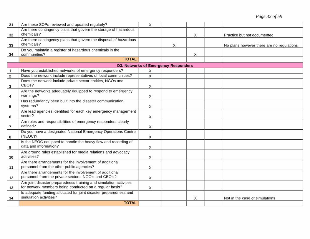
31 Are these SOPs reviewed and updated regularly? X
32 Are there contingency plans that govern the storage of hazardous chemicals? X Practice but not documented
33 Are there contingency plans that govern the disposal of hazardous chemicals? X No plans however there are no regulations
34 Do you maintain a register of hazardous chemicals in the communities? X
TOTAL D3. Networks of Emergency Responders
1 Have you established networks of emergency responders? X 2 Does the network include representatives of local communities? X
3 Does the network include private sector entities, NGOs and CBOs? X
4 Are the networks adequately equipped to respond to emergency warnings? X
5 Has redundancy been built into the disaster communication systems? X
6 Are lead agencies identified for each key emergency management sector? X
7 Are roles and responsibilities of emergency responders clearly defined? X
8 Do you have a designated National Emergency Operations Centre (NEOC)? X
9 Is the NEOC equipped to handle the heavy flow and recording of data and information? X
10 Are ground rules established for media relations and advocacy activities? X
11 Are there arrangements for the involvement of additional personnel from the other public agencies? X
12 Are there arrangements for the involvement of additional personnel from the private sectors, NGO’s and CBO’s? X
13 Are joint disaster preparedness training and simulation activities for network members being conducted on a regular basis? X
14 Is adequate funding allocated for joint disaster preparedness and simulation activities? X Not in the case of simulations
TOTAL

Page 33 of 59
D4. Shelter Facilities and Evacuation Plans 1 Has a national shelter policy been developed and approved? X
2 Does the shelter policy include a timeframe for the occupation of essential services identified as shelters? X
3 Are these shelters accessible to all vulnerable communities? X
4 Do the shelters have adequate facilities for the affected population? X Some facilities
5 Are the shelters safe from the impacts of the followings? All shelters are for after the event 5a earthquake hazards X Would depend on location
5b volcanic hazards?
X Would depend on geographic location of shelter and magnitude of eruption
5c landslide hazards? X Geographic location 5d flood hazards? X “ 5e hurricane wind hazards? X “ 5f storm surge hazards? X “ 5g technological hazards? X “ 5h biological hazards? X “
5i Are the shelters prone to the impact of any other hazard? Specify______________ X Fire, civil unrest, explosion ect.
6 Is there a national emergency evacuation plan? X 7 Is there a shelter security plan or guidelines? X There are guidelines to be followed
8 Have evacuation routes to shelters been clearly defined and demarcated? X Defined but not demarcated
9 Is there training in shelter management? X 10 Have alternate routes been identified and demarcated? X Defined but not demarcated 11 Do all members of the communities know the evacuation routes? X Not possible to know
12 Is there an effective coordination of transport and communication networks for shelters? X
13 Is the issuance of an evacuation order supported by legislation? X Has to be accented by Order of the Minister 14 Is emergency evacuation mandatory by law? X 16 Has a donation policy been defined and approved? X 17 Has a relief policy been clearly defined and approved? X
18 Has policy for the use of emergency housing assistance been clearly defined and approved? X
19 Are there arrangements for monitoring and evaluating the effectiveness of disaster preparedness plans? X
TOTAL

Page 34 of 59
E. Emergency Response
E1. Emergency Response Plan and Humanitarian Assistance
1 Does the country have an approved emergency response plan for all prevalent hazards? X Emergency management plan
2 Is there a response plan for terrorist attack? X 3 Is there a response plan for mass casualties? X 4 Is the response plan gender sensitive? X mutual
5 Do you have a national emergency response planning committee? X Pr-strike meeting
6 Are regular training workshops held for members of the emergency response team? X
7 Are the plans annually tested and reviewed? X
8 Are financial resources adequately allocated for the implementation of the plans? X Funding is inadequate
9 Are the required technical and human resources clearly identified? X
10 Are members of the response team trained in marine search and rescue? X
11 Are members of the response team trained in urban search and rescue? X
12 Do you have adequate resources for the development of response plans? X
13 Are corporate institutions officially required to have emergency response plans? X
14 Are corporate emergency response plans developed in consultation with the National Disaster Organization? X Some do some don’t
15 Are requirements for emergency response plans required by law? X
16 Are roles and responsibilities clearly defined in the response plans? X
17 Does the response plan outline evacuation routes and procedures? X
18 Does the response plan outline emergency notification procedures? X
19
Does the response plan make provisions for the evacuation of children, the elderly, and other persons with mobility challenges? X
20 Does the response plan have containment procedures? Containment? Don’t understand.
21 Are the details of the response plan shared with the population at risk? X Awaiting quotes from printers.

Page 35 of 59
22 Is the response plan supported by disaster risk maps? X
23 Are the criteria for evaluating the level of emergency response defined? X X
24 Are communication and information handling and processing protocols clearly defined and responsibilities assigned? X
25 Are there mechanisms for monitoring the effectiveness of the plan? X
26
Have partnership agreements been negotiated and concluded with public and private sectors as well as CBOs and NGOs that may enhance emergency response plans? X
27 Have agencies that offered humanitarian assistance been involved in pre-event planning? X
28 Have clear roles and responsibilities been established for emergency planners, responders, and managers? X
29 Has a coordinated command system been planned to ensure effective response at multiple sites? X
30 Have potential casualty collection points for triage and transport of the injured been identified? X
31 Has additional mortuary space been identified? X
32 Have health and sanitation supplies been moved to collection points and shelters? X
TOTAL
E2. Clean-up, Temporary Repairs, and Restoration of Services
1 Have clean-up, repair, and restoration teams been identified and trained? X
2 Has a clear strategy for deployment of these teams been developed? X
Some procedure in place but nothing officially documented
3 Have the tools and transportation required for clean-up been assembled? X Some available
4 Is there an established site-specific database on past damage? X Sector specific rather than site specific
5 Is this database used to inform and prioritize new projects, upgrading and clean-up activities? X To some extent
6 Is the cost of impact quantified based on currency value? x TOTAL

Page 36 of 59
E3. Damage Assessment
1 Has a common damage assessment methodology been adopted for the country? X
2 Have training materials been developed based on this methodology? X
3 Have damage assessment teams been identified? X
4 Have the damage assessment teams been trained using a standardized methodology? X
5 Do you maintain a national database of damage to properties? x Some properties 6 Do you maintain a national database of cost of damage? X
7 Is there legislation or policies for the undertaking of damage assessment and training? x
8 Is disaggregated post disaster data which is required for the damage assessments available? x
9 Is there regular update of post disaster data? X
10 Do you maintain a national database of damage claims for both insured and uninsured properties? X
TOTAL
E4. Mobilization of Recovery Resources 1 Has a disaster recovery policy been defined and approved? x
2 Do you have a comprehensive inventory of government resources that may be used for disaster recovery efforts? X May not be Comprehensive
3 Do you have a comprehensive inventory of private sector resources that may be used for disaster recovery efforts? X
4 Are there established MOUs with private sector companies to assist in recovery activities? X Not anymore
5 Have community resources that may be used for recovery efforts been identified and inventoried? X
6 Is there strategic pre-positioning of supplies or resources for ‘quick response’? X
7 Is there community level training to support disaster response? X
8 Are there arrangements for monitoring and evaluating the effectiveness of the emergency response plans? X There is after action review
TOTAL

Page 37 of 59
F. Rehabilitation and Reconstruction
F1. Rehabilitation and reconstruction of damaged infrastructure
1 Does a national disaster rehabilitation/recovery policy and plan exist? x
If YES, answer the following questions. If NO, go to question 2.
1a. Does the plan include infrastructural prioritization for reconstruction /rehabilitation? X
1b. Does the plan contain strategies for impact assessment, rehabilitation and reconstruction? X
1c. Does the plan identify essential skills and personnel needed? X
1d.
Does the plan identify essential equipment, service providers, technical experts, construction contractors, and telecommunications providers? X
1e. Does the plan have strategies for road clearance and reconstruction? X
1f. Does the plan have strategies for electricity restoration? X 1g. Does the plan have strategies for telecommunications restoration? X 1h. Does the plan have strategies for water supply restoration? X
1i. Does the plan have strategies for restoration of the health services? X Plan is incomplete
1j. Does the plan have strategies for restoration of the financial sector? X X
1k. Does the plan have strategies for restoration of services at the airports and seaports? X X
2 Do you have plans for the safe disposal of debris? X
3 Do you have plans for the safe disposal of hazardous waste materials? X
4 Is there spatial prioritization in rehabilitation/reconstruction of infrastructure? X Essential services restoration
5 Has a current inventory of sources of supply for rehabilitation and reconstruction materials been made? x
6 Has a purchasing agreement been made with the relevant suppliers? X
7 Is the disaster recovery plan annually reviewed? 8 Is the disaster recovery plan annually rehearsed and tested? X

Page 38 of 59
9 Do you have post-event assessment teams to determine causes of failures and reasons for success? X
10 Are the results of this assessment widely disseminated? X
11 Do the results of damage assessment inform reconstruction polices? X To some extent
TOTAL F2. Macroeconomic and Budget Management
1 Is there national budgetary allocation for rehabilitation and/or reconstruction? X
If YES, answer the following question. If NO, go to question 2.
1a. Is there sectoral budgetary allocation for rehabilitation and/or reconstruction? X
If YES, answer the following questions. If NO, go to question 2.
1b. Is the allocation based on objectively defined criteria? X
2 Is budgetary allocation for rehabilitation and reconstruction informed by past damages? X
3 Do disaster risk reduction policies guide fiscal and development planning? X
4 Is there a system of public accountability in relation to expenditure for rehabilitation/reconstruction? X
5 Is there policy guidance for budget management in relation to rehabilitation/reconstruction? X
6 Is more than 5% of your national budget dedicated to disaster risk reduction? X
TOTAL
F3. Revitalization for Affected Sectors 1 Are there plans for the revitalization of social sectors? X 2 Are there plans for the revitalization of economic sectors? X Some sectors
3 Are the priorities for the revitalization of the social sectors clearly defined? X
4 Are the priorities for the revitalization of the economic sectors clearly defined? X Defined in practice
5 Are sectoral priorities objectively determined and reviewed? X 6 Are there community-level plans for sectoral revitalization? X 7 Are the NGOs involved in sectoral revitalization? X Some are 8 Does the revitalization plan incorporate risk reduction activities? X For some entities

Page 39 of 59
9 Are there participation and partnerships between public and private entities for revitalization of affected sectors? X
10 Are there business continuity plans for educational institutions? X Work in progress 11 Are there business continuity plans for health facilities? X Work in progress 12 Are there business continuity plans for prisons facilities? X Never seen one – Model provided 13 Are there business continuity plans for government services? X Work in progress
14 Are there business continuity plans for the private sector?
X Work in progress – one day we will cover the thousands that exist
15 Are there business continuity plans for the justice system? X Work in progress 16 Are there business continuity plans for governance? X Work in prgress
17 Are there business continuity plans for the armed forces?
Not Applicable – No Armed Force in Saint Lucia
TOTAL
F4. Incorporation of Disaster Mitigation Components in Reconstruction Activities
1 Is identification of structural failure part of the post-impact assessment process? X
2 Is identification of non-structural failure part of the post impact assessment process? X
3 Is there a phased assessment of non-structural failure? X In some instances
4 Are reconstruction/rehabilitation activities informed by past failure? X To some extent
5 Are there systems to identify and promote awareness of past structural failures? X
6 Are there systems to identify and promote awareness of past non-structural failures? X
There is no promotion however structural failure are identified
7 Are there arrangements for monitoring and evaluating the effectiveness of rehabilitation and reconstruction plans? X
8 Do you conduct or facilitate research on disaster risk management? X NEMO facilitates but does not research
9 Are there measures to identify and promote awareness of successful mitigation measures X
TOTAL

Page 40 of 59
Country Fast Fact Would you kindly provide the following basic information with respect to your country?
Country Name: Saint Lucia Year Demographics Indicators 2002 2003 2004 2005 2006P
1. Total population 159,133 160,620 162,434 164,587 166,838 2. Total male population 77,868 78,629 79,407 80,549 81,679 3. Total female population 81,265 81,991 83,027 84,038 85,159 4. Total population under 15 years 48,336 47,497 46,903 46,704 46,614 5. Total population over 70 years 8,068 7,952 7,884 7,799 7,834 6. Land Area (sq km) 101.5 101.5 101.5 101.5 101.5
Financial Indicators: GDP by Sector 2002 2003 2004 2005 2006
1. Agriculture 67.33 56.73 55.10 41.47 45.52 2. Hotels & Restaurants 138.35 161.36 170.86 181.67 176.70 3. Transport 120.70 125.95 135.18 133.81 135.68 4. Communications 129.56 135.43 141.65 152.05 151.72 5. Real Estate & Housing 149.63 154.62 159.68 168.78 173.18 6. Total
Risk Management Budget 2002 2003 2004 2005 2006
1. Risk Identification 0 0 0 0 0 2. Risk Mitigation 0 0 0 0 0 3. Risk Transfer $19,369.88 $19,369.88 $19,369.88 $19,369.88 $19,369.88 4. Disaster Preparedness $289,206.00 $292,126.00 $304,577.00 $350,530.00 $423,234.00 5. Emergency Response $500,000.00 $500,000.00 $500,000.00 $500,000.00 $500,000.00 6. Rehabilitation and Reconstruction
As needed As needed As needed As needed As needed
History of Natural Disaster 2002 2003 2004 2005 2006 1. Hurricane storms 1 1 1 1 0 2. Flooding 3. Earthquakes 5 7 4 8 3 4. Volcanic Eruptions 0 0 0 0 0 5. Landslides [Major] 1 2

Page 41 of 59
GLOSSARY Acceptable risk The level of loss a society or community considers acceptable given existing social, economic, political, cultural, technical and environmental conditions. In engineering terms, acceptable risk is also used to assess structural and non-structural measures undertaken to reduce possible damage at a level which does not harm people and property, according to codes or "accepted practice" based, among other issues, on a known probability of hazard. Biological hazard Processes of organic origin or those conveyed by biological vectors, including exposure to pathogenic micro-organisms, toxins and bioactive substances, which may cause the loss of life or injury, property damage, social and economic disruption or environmental degradation. Examples of biological hazards: outbreaks of epidemic diseases, plant or animal contagion, insect plagues and extensive infestations. Building codes Ordinances and regulations controlling the design, construction, materials, alteration and occupancy of any structure to insure human safety and welfare. Building codes include both technical and functional standards. Capacity A combination of all the strengths and resources available within a community, society or organization that can reduce the level of risk, or the effects of a disaster. Capacity may include physical, institutional, social or economic means as well as skilled personal or collective attributes such as leadership and management. Capacity may also be described as capability. Capacity building Efforts aimed to develop human skills or societal infrastructures within a community or organization needed to reduce the level of risk. In extended understanding, capacity building also includes development of institutional, financial, political and other resources, such as technology at different levels and sectors of the society. Climate change The climate of a place or region is changed if over an extended period (typically decades or longer) there is a statistically significant change in measurements of either the mean state or variability of the climate for that place or region. Changes in climate may be due to natural processes or to persistent anthropogenic changes in atmosphere or in land use. Note that the definition of climate change used in the United Nations Framework Convention on Climate Change is more restricted, as it includes only those changes which are attributable directly or indirectly to human activity. Community A political or social entity which has a formal or socially recognized authority to adopt and enforce laws and ordinances for the area under its jurisdiction. In most cases, the community is an incorporated town, city, township, village, or unincorporated area of a county. However, each State defines its own political subdivisions and form s of government. Complex Disasters Complex disasters exist where adverse political conditions compound a disaster or emergency situation. Such situations are complicated because the breakdown of the political structure makes assistance or intervention difficult. This sort of emergency is usually associated with the problems of displaced people during times of civil conflict or with people in need caught in areas of conflict. Comprehensive Disaster Management (CDM) This is the new thrust for the 21st Century being promoted by CDERA. It moves away from the approach of “response and relief” which characterized Caribbean disaster management in the last century to a comprehensive mode to include all hazards, all phases of the disaster management continuum (prevention, mitigation, preparedness, response, recovery,

Page 42 of 59
rebuilding), and all sectors of the society (economic, environmental, and social planners, engineers, architects, insurance and banking industry among others). Coping capacity The means by which people or organizations use available resources and abilities to face adverse consequences that could lead to a disaster. In general, this involves managing resources, both in normal times as well as during crises or adverse conditions. The strengthening of coping capacities usually builds resilience to withstand the effects of natural and human-induced hazards. Counter measures All measures taken to counter and reduce disaster risk. They most commonly refer to engineering (structural) measures but can also include non-structural measures and tools designed and employed to avoid or limit the adverse impact of natural hazards and related environmental and technological disasters. Damage Assessment The process used to appraise or determine the number of injuries and deaths, damage to public and private property, and the status of key facilities and services such as hospitals and other health care facilities, fire and police stations, communications networks, water and sanitation systems, utilities, and transportation networks resulting from a man-made or natural disaster. Decontamination The reduction or removal of a chemical, biological, or radiological material from the surface of a structure, area, object, or person. Density Bonus An increase in the density otherwise allowed in a given zoning district which may be granted under specific provisions of the Zoning Ordinance when a developer provides excess open space, recreation facilities, or affordable dwelling units (ADUs), etc. www.co.fairfax.va.us/dpz/zoning/glossary/cd.htm Disaster A serious disruption of the functioning of a community or a society causing widespread human, material, economic or environmental losses which exceed the ability of the affected community or society to cope using its own resources. Though often caused by nature, disasters can have human origins. Wars and civil disturbances that destroy homelands and displace people are included among the causes of disasters. Other causes can be: building collapse, blizzard, drought, epidemic, earthquake, explosion, fire, flood, hazardous material or transportation incident (such as a chemical spill), hurricane, nuclear incident, tornado, or volcano. A disaster is a function of the risk process. It results from the combination of hazards, conditions of vulnerability and insufficient capacity or measures to reduce the potential negative consequences of risk. Disaster Management This is a collective term, which includes all aspects of planning for and responding to disasters. It may also refer to the management of both the risks and consequence of disasters. Disaster Recovery Center Places established in the area declared to have major disaster, as soon as practicable, to provide victims the opportunity to apply in person for assistance and/or obtain information relating to that assistance. DRCs are staffed by local, national, regional agency representatives, as well as staff from volunteer organizations (e.g., the Red Cross).

Page 43 of 59
Disaster risk management The systematic process of using administrative decisions, organization, operational skills and capacities to implement policies, strategies and coping capacities of the society and communities to lessen the impacts of natural hazards and related environmental and technological disasters. This comprises all forms of activities, including structural and non-structural measures to avoid (prevention) or to limit (mitigation and preparedness) adverse effects of hazards. Disaster risk reduction (disaster reduction) The conceptual framework of elements considered with the possibilities to minimize vulnerabilities and disaster risks throughout a society, to avoid (prevention) or to limit (mitigation and preparedness) the adverse impacts of hazards, within the broad context of sustainable development. The disaster risk reduction framework is composed of the following fields of action: Risk awareness and assessment including hazard analysis and vulnerability/capacity analysis; Knowledge development including education, training, research and information; Public commitment and institutional frameworks, including organisational, policy, legislation and community action; Application of measures including environmental management, land-use and urban planning, protection of critical facilities, application of science and technology, partnership and networking, and financial instruments; Early warning systems including forecasting, dissemination of warnings, preparedness measures and reaction capacities. Early warning The provision of timely and effective information, through identified institutions, that allows individuals exposed to a hazard to take action to avoid or reduce their risk and prepare for effective response. Early warning systems include a chain of concerns, namely: understanding and mapping the hazard; monitoring and forecasting impending events; processing and disseminating understandable warnings to political authorities and the population, and undertaking appropriate and timely actions in response to the warnings. Earthquake The sudden motion or trembling of the ground produced by abrupt displacement of rock masses, usually within the upper 10 to 20 miles of the earth's surface. Emergency Any occasion or instance--such as a hurricane, tornado, storm, flood, tidal wave, tsunami, earthquake, volcanic eruption, landslide, mudslide, snowstorm, fire, explosion, nuclear accident, or any other natural or man-made catastrophe--that warrants action to save lives and to protect property, public health, and safety. Emergency Alert System A digital technology (voice/text) communications system consisting of broadcast stations and interconnecting facilities authorized by the Federal Communication Commission. The system provides the National and local officials the means to broadcast emergency information to the public before, during, and after disasters. Emergency Health Services Services required to prevent and treat the damaging health effects of an emergency, including communicable disease control, immunization, laboratory services, dental and nutritional services; providing first aid for treatment of ambulatory patients and those with minor injuries; providing public health information on em ergency treatment, prevention, and control; and providing administrative support including maintenance of vital records and providing for a conduit of emergency health funds from State and Federal governments. Emergency Management The organization and management of resources and responsibilities for dealing with all aspects of emergencies, in particularly preparedness, response and rehabilitation. Emergency management involves plans, structures and arrangements established to engage the normal endeavours of government, voluntary and private agencies in a

Page 44 of 59
comprehensive and coordinated way to respond to the whole spectrum of emergency needs. This is also known as disaster management. Emergency Medical Services Services, including personnel, facilities, and equipment required to ensure proper medical care for the sick and injured from the time of injury to the time of final disposition, including medical disposition within a hospital, temporary medical facility, or special care facility, release from site, or declared dead. Further, emergency medical services specifically include those services immediately required to ensure proper medical care and specialized treatment for patients in a hospital and coordination of related hospital services. Emergency Operati ng Center The protected site from which State and local civil government officials coordinate, monitor, and direct emergency response activities during an emergency. Emergency Operations Plan A document that: describes how people and property will be protected in disaster and disaster threat situations; details who is responsible for carrying out specific actions; identifies the personnel, equipment, facilities, supplies, and other resources available for use in the disaster; and outlines how all actions will be coordinated. Emergency preparedness Emergency preparedness deals with planning and actions undertaken in advance of a possible or probable disaster to protect life and economic losses with a focus on the most vulnerable populations. Emergency Response Planning Exercises, Emergency Preparedness, Public Awareness, Communication and Information Management Systems and Technical Emergency Response Capacity are the key components of emergency preparedness framework. Environmental Impact Assessment (EIA) Studies undertaken in order to assess the effect on a specified environment of the introduction of any new factor, which may upset the current ecological balance. EIA is a policy making tool that serves to provide evidence and analysis of environmental impacts of activities from conception to decision-making. It is utilised extensively in national programming and for international development assistance projects. An EIA must include a detailed risk assessment and provide alternatives solutions or options. Environmental degradation The reduction of the capacity of the environment to meet social and ecological objectives, and needs. Potential effects are varied and may contribute to an increase in vulnerability and the frequency and intensity of natural hazards. Some examples: land degradation, deforestation, desertification, wildland fires, loss of biodiversity, land, water and air pollution, climate change, sea level rise, and ozone depletion. Environmental measures Environmental risk reduction measures are designed to protect existing or rehabilitate degraded environmental systems that have the capacity to reduce the impacts of natural hazards. These can take the form of policies and programs, such as development control or environmental impact assessments, which reduce or eliminate the effect of human activities on the environment. They can also include physical measures that restore or fortify damaged environmental systems. Secondary effects of hazard events, such as oil spills caused by flooding, must also be addressed as they often cause more significant environmental damage than do primary effects. Evacuation Organized, phased, and supervised dispersal of people from dangerous or potentially dangerous areas.

Page 45 of 59
• Spontaneous Evacuation. Residents or citizens in the threatened areas observe an emergency event or receive unofficial word of an actual or perceived threat and without receiving instructions to do so, elect to evacuate the area. Their movement means, and direction of travel is unorganized and unsupervised.
• Voluntary Evacuation. This is a warning to persons within a designated area that a threat to life and property exists
or is likely to exist in the immediate future. Individuals issued this type of waning or order are NOT required to evacuate, however it would be to their advantage to do so.
• Mandatory or Directed Evacuation. This is a warning to persons within the designated area that an imminent threat
to life and property exists and individuals MUST evacuate in accordance with the instructions of local officials. Evacuees All persons removed or moving from areas threatened or struck by a disaster. Flash Flood Follows a situation in which rainfall is so intense and severe and runoff so rapid that it precludes recording and relating it to stream stages and other information in time to forecast a flood condition. Flood A general and temporary condition of partial or complete inundation of normally dry land areas from overflow of inland or tidal waters, unusual or rapid accumulation or runoff of surface waters, or mudslides/mudflows caused by accumulation of water. Forecast Definite statement or statistical estimate of the occurrence of a future event (UNESCO, WMO). This term is used with different meanings in different disciplines. Geological hazard Natural earth processes or phenomena that may cause the loss of life or injury, property damage, social and economic disruption or environmental degradation. Geological hazard includes internal earth processes or tectonic origin, such as earthquakes, geological fault activity, tsunamis, volcanic activity and emissions as well as external processes such as mass movements: landslides, rockslides, rock falls or avalanches, surfaces collapses, expansive soils and debris or mud flows. Geological hazards can be single, sequential or combined in their origin and effects. Hazard A hazard is an extreme, threatening event in the natural or man-made environment that adversely affects human life, property, or activity, or the ecosystem that supports them. A primary hazard disrupts human settlements. A secondary hazard occurs in the aftermath of a primary hazard and contributes to further suffering or loss. Hazard analysis Identification, studies and monitoring of any hazard to determine its potential, origin, characteristics and behaviour. Hazard assessment and mapping Hazard assessments are studies that provide information on the probable location and severity of dangerous natural phenomena and the likelihood of their occurrence within a specific time period in a given area. These studies rely heavily on available scientific information, including geologic, geomorphic, and soil maps; climate and hydrological data; and topographic maps, aerial photographs, and satellite imagery. Historical information, both written reports and oral accounts from long-term residents, also helps characterize potential hazardous events. Ideally, a natural hazard assessment promotes an awareness of the issue among all stakeholders in an affected area, evaluates the threat of natural hazards, and describes the distribution of historical or potential hazard effects across the study area.

Page 46 of 59
Hazard Mitigation Any action taken to reduce or eliminate the long-term risk to human life and property from hazards. The term is sometimes used in a stricter sense to mean cost-effective measures to reduce the potential for damage to a facility orfacilities from a disaster event. Hazardous Material Any substance or material that when involved in an accident and released in sufficient quantities, poses a risk to people's health, safety, and/or property. These substances and materials include explosives, radioactive materials, flammable liquids or solids, combustible liquids or solids, poisons, oxidizers, toxins, and corrosive materials. High-Hazard Areas Geographic locations that for planning purposes have been determined through historical experience and vulnerability analysis to be likely to experience the effects of a specific hazard (e.g., hurricane, earthquake, hazardous materials accident, etc.) resulting in vast property damage and loss of life. Hurricane A tropical cyclone, formed in the atmosphere over warm ocean areas, in which wind speeds reach 74 miles per hour or more and blow in a large spiral around a relatively calm center or "eye". Circulation is counter-clockwise in the Northern Hemisphere and clockwise in the Southern Hemisphere. Hydro-meteorological hazards Natural processes or phenomena of atmospheric, hydrological or oceanographic nature, which may cause the loss of life or injury, property damage, social and economic disruption or environmental degradation. Hydro-meteorological hazards include: floods, debris and mud floods; tropical cyclones, storm surges, thunder/hailstorms, rain and wind storms, blizzards and other severe storms; drought, desertification, wildland fires, temperature extremes, sand or dust storms; permafrost and snow or ice avalanches. Hydro-meteorological hazards can be single, sequential or combined in their origin and effects. Incident Command System A standardized organizational structure used to command, control, and coordinate the use of resources and personnel that have responded to the scene of an emergency. The concepts and principles for ICS include common terminology, modular organization, integrated communication, unified command structure, consolidated action plan, manageable span of control, designated incident facilities, and comprehensive resource management. Joint Information Center A central point of contact for all news media near the scene of a large-scale disaster. News media representatives are kept informed of activities and events by public information officials who represent all participating agencies that are collocated at the JIC. Land-use planning Branch of physical and socio-economic planning that determines the means and assesses the values or limitations of various options in which land is to be utilized, with the corresponding effects on different segments of the population or interests of a community taken into account in resulting dec isions. Land-use planning involves studies and mapping, analysis of environmental and hazard data, formulation of alternative land-use decisions and design of a long-range plan for different geographical and administrative scales. Land-use planning can help to mitigate disasters and reduce risks by discouraging high-density settlements and construction of key installations in hazard-prone areas, control of population density and expansion, and in the siting of service routes for transport, power, water, sewage and other critical facilities. Mass Care The actions that are taken to protect evacuees and other disaster victims from the effects of the disaster. Activities include providing temporary shelter, food, medical care, clothing, and other essential life support needs to those people that have been displaced from their homes because of a disaster or threatened disaster.

Page 47 of 59
Mitigation Structural and non-structural measures undertaken to limit the adverse impact of natural hazards, environmental degradation and technological hazards. Natural hazards Natural processes or phenomena occurring in the biosphere that may constitute a damaging event. Natural hazards can be classified by origin namely: geological, hydro-meteorological or biological. Hazardous events can vary in magnitude or intensity, frequency, duration, area of extent, speed of onset, spatial dispersion and temporal spacing. Post-disaster measures In the aftermath of a disaster, there is great pressure to repair damage quickly. However, the quality of the reconstruction and rehabilitation work that takes place during this period often determines how well the same system weathers future hazard events. Time and budget pressures and the difficulties in communication and transport in the post-disaster environment make it difficult to increase resilience during reconstruction. Putting in place pre-approved and tested reconstruction plans and procedures, with identified financing, can significantly reduce vulnerability to future hazard events, while overcoming the traditional time and budget constraints. Although reconstruction measures are a component of long-term response and recovery, they can form a critical component of a comprehensive risk reduction program, as the recovery period provides an important window of opportunity for implementing necessary risk reduction measures. Preparedness Activities and measures taken in advance to ensure effective response to the impact of hazards, including the issuance of timely and effective early warnings and the temporary evacuation of people and property from threatened locations. Measures to arrange for the effective and opportune provision of early warnings, search and rescue, and emergency and rehabilitation management; measures to help limit the time and scope of disaster impact, including second-order effects such as disease and collateral damage. Prevention Activities to provide outright avoidance of the adverse impact of hazards and means to minimize related environmental, technological and biological disasters. Depending on social and technical feasibility and cost/benefit considerations, investing in preventive measures is justified in areas frequently affected by disasters. In the context of public awareness and education, related to disaster risk reduc tion changing attitudes and behaviour contribute to promoting a "culture of prevention". Public awareness The processes of informing the general population, increasing levels of consciousness about risks and how people can act to reduce their exposure to hazards. This is particularly important for public officials in fulfilling their responsibilities to save lives and property in the event of a disaster. Public awareness activities foster changes in behaviour leading towards a culture of risk reduction. This involves public information, dissemination, education, radio or television broadcasts, use of printed media, as well as, the establishment of information centres and networks and community and participation actions. Public information Information, facts and knowledge provided or learned as a result of research or study, available to be disseminated to the public. Recovery Decisions and actions taken after a disaster with a view to restoring or improving the pre-disaster living conditions of the stricken community, while encouraging and facilitating necessary adjustments to reduce disaster risk. Recovery (rehabilitation and reconstruction) affords an opportunity to develop and apply disaster risk reduction measures.

Page 48 of 59
Rehabilitation The restoration of basic services and the beginning of the repair of physical, social and economic damage. Relief / response The provision of assistance or intervention during or immediately after a disaster to meet the life preservation and basic subsistence needs of those people affected. It can be of an immediate, short-term, or protracted duration. Resilience / resilient The capacity of a system, community or society potentially exposed to hazards to adapt, by resisting or changing in order to reach and maintain an acceptable level of functioning and structure. This is determined by the degree to which the social system is capable of organizing itself to increase its capacity for learning from past disasters for better future protection and to improve risk reduction measures. Resource Management Those actions taken by a government to: identify sources and obtain resources needed to support disaster response activities; coordinate the supply, allocation, distribution, and delivery of resources so that they arrive where and when most needed; and maintain accountability for the resources used. Retrofitting (or upgrading) Reinforcement of structures to become more resistant and resilient to the forces of natural hazards. Retrofitting involves consideration of changes in the mass, stiffness, damping, load path and ductility of materials, as well as radical changes such as the introduction of energy absorbing dampers and base isolation systems. Examples of retrofitting include the consideration of wind loading to strengthen and minimize the wind force, or in earthquake prone areas, the strengthening of structures. Risk Risk is expected loss (deaths, injuries, damage to property or ecosystem on which human life depends, and disruption of economic activity) due to a particular hazard. The probability of harmful consequences, or expected losses (deaths, injuries, property, livelihoods, economic activity disrupted or environment damaged) resulting from interactions between natural or human-induced hazards and vulnerable conditions. Conventionally risk is expressed by the notation: Risk = Hazards x Vulnerability. Some disciplines also include the concept of exposure to refer particularly to the physical aspects of vulnerability. Beyond expressing a possibility of physical harm, it is crucial to recognize that risks are inherent or can be created or exist within social systems. It is important to consider the social contexts in which risks occur and that people therefore do not necessarily share the same perceptions of risk and their underlying causes. Risk assessment/analysis A methodology to determine the nature and extent of risk by analyzing potential hazards and evaluating existing conditions of vulnerability that could pose a potential threat or harm to people, property, livelihoods and the environment on which they depend. The process of conducting a risk assessment is based on a review of both the technical features of hazards such as their location, intensity, frequency and probability; and also the analysis of the physical, social, economic and environmental dimensions of vulnerability and exposure, while taking particular account of the coping capabilities pertinent to the risk scenarios. Risk Identification A thorough understanding of existing vulnerabilities, including their location and severity, is critical for the development and prioritization of investment programs and activities for hazard risk management. As the level of vulnerability can increase, or decline, with the aging of existing facilities and with new growth, determining underlying causes makes it possible to eliminate or reduce new vulnerabilities as communities, countries and the region as a whole develop. A broad range of

Page 49 of 59
activities contributes to the identification and understanding of natural hazard risk: hazard data collection and mapping, vulnerability assessment, risk assessment and post-disaster assessment. Risk mitigation Measures that attempt to reduce existing risk as well as measures to reduce the consequential damage and loss occasioned by a dangerous event once it occurs. Mitigation assumes that it is not feasible to avoid or control risk completely but that risk can be reduced to levels that are acceptable or feasible. Risk Reduction Risk reduction activities are designed to mitigate damage from hazard events. These activities address existing vulnerability through such measures as retrofit, strengthening and relocation. Actions taken to reduce future vulnerability, such as the implementation and enforcement of building standards, environmental protection measures, land use planning that recognizes hazard zones and resource management practices, will provide significant benefits over the long term. Risk reduction measures should lead to “safer” growth, rather than a further accumulation of vulnerability. However, they should always complement activities to safeguard individuals and resources exposed to existing vulnerabilities. Risk reduction measures can be directed towards physical, social and environmental vulnerability. Risk Transfer Mechanisms for passing on and spreading financial consequences; such mechanisms must be in place before damage occurs; insurance markets are key; risk transfer also occurs through public finance mechanisms funded by domestic and international sources.
Budget self-insurance The owner of a property—the government, a private company or an individual—allocates a modest yearly budget to spend on improved maintenance and on selected retrofit investments, which have the effect of reducing future expected losses in the event of a disaster. This enables the owner either to forego the purchase of regular insurance or to accept a higher deductible, thus reducing the cost of insurance.
Market insurance and reinsurance Insurance provides coverage for damage and expenses that are beyond the potential for budget self-insurance. Market insurance stabilizes loss payments through pre-payment in the form of regular premium payments. Once the extent of coverage has been agreed and premiums paid under an insurance contract, the insurer assumes the risk. Insurance makes available funds necessary to repair damage or rebuild shortly after a disaster event. Insurance costs for certain categories of buildings or uses, however, may be unaffordable. Coverage for some categories of natural hazards may also be unavailable. Business interruption insurance can help companies and their employees survive the recovery and rehabilitation period. It is important to note that insurance as a mechanism does not reduce actual vulnerability and is inefficient from a cost perspective. Consequently, all efforts to reduce the vulnerability of the assets to be insured should be taken before transferring the risk through insurance. To be sustainable, insurance mechanisms should qualify risks and strive to bring in good risks, not serve as a dumping ground for bad or unwise risks. Great reliance on reinsurance in the Caribbean makes insurance prices in the region vulnerable to shocks unrelated to immediate disaster experiences in the region.
Public asset coverage Most public assets are not covered by insurance. Funds for rebuilding damaged assets must come from annual budgets or external sources. This puts great pressure on public budgets in the post-disaster period when economies are often particularly weak, as typically little has been set aside for budget self-insurance purposes. Insurance coverage for critical public assets will ensure that key infrastructure can be rebuilt or rehabilitated quickly if damaged in a hazard event. Selection of assets that merit insurance coverage should be based on careful prioritization public facilities and on comprehensive facility vulnerability assessments.

Page 50 of 59
Risk pooling and diversification Insurance costs for geographically concentrated or relatively homogeneous groups or facilities are often high, due to the potential for simultaneous damage to all members of the group or category. Diversification of the risk pool, through banding with others from other areas or industries can result in reduced insurance premiums for all partic ipants.
Risk financing Risk financing mechanisms allow losses to be paid off in the medium - to long-term via some form of a credit facility. Alternative risk financing mechanisms provide cost-effective, multi-year coverage that assists with the stabilization of premiums and increases the availability of funds for insurance purposes. Examples of such mechanisms include credit backstop facilities and finite insurance mechanisms. Socio-economic measures Social risk reduction measures are designed to address gaps and weaknesses in the systems whereby communities and society as a whole prepare for and respond to disaster events. These measures are typically the responsibility of the National Disaster Offices and associated district- or community-level organizations. Effective community- and national-level social networks and health systems can also contribute to assuring continuity and recovery after a disaster event. Weaknesses in these systems are often concentrated in disadvantaged areas and groups. Awareness programs addressing existing hazards and physical and social vulnerabilities are often central to social risk reduction. Standard Operating Procedure A set of instructions constituting a directive, covering those features of operations which lend themselves to a definite, step-by-step process of accomplishment. SOPs supplement EOPs by detailing and specifying how tasks assigned in the EOP are to be carried out. Storm Surge A dome of sea water created by the strong winds and low barometric pressure in a hurricane that causes severe coastal flooding as the hurricane strikes land. Structural and non-structural measures Structural measures refer to any physical construction to reduce or avoid possible impacts of hazards, which include engineering measures and construction of hazard-resistant and protective structures and infrastructure. It also includes any actions that require the construction or strengthening of facilities or altering of the environment to reduce the effects of a hazard event. Measures to strengthen public - and private-sector buildings or facilities include flood- and wind proofing, elevation, seismic retrofitting and burial (e.g. utilities). Such measures are designed to reduce or eliminate damage to structures and their contents and functions. Environment alteration measures are designed to stabilize an otherwise unstable or hazardous area, to redirect a hazard or to reinforce natural systems that buffer hazard effects. Such measures include sediment trapping structures, shore protection and flood control works, slope stabilization, brush clearing and wetlands protection. Non-structural measures refer to policies, awareness, knowledge development, public commitment, and methods and operating practices, including participatory mechanisms and the provision of information, which can reduce risk and related impacts. It also includes changes to policies and programs that guide future development and investment towards reduced vulnerability to hazards. Examples of non-structural measures include physical development planning, development regulations, acquisition of hazardous properties, tax and fiscal incentives and public education. Typically, non-structural measures are significantly less costly than structural measures, but they have little immediate effect on reducing vulnerability and require oversight by the government to ensure continued, proper implementation. Sustainable development Development that meets the needs of the present without compromising the ability of future generations to meet their own needs. It contains within it two key concepts: the concept of "needs", in particular the essential needs of the world's poor, to which overriding priority should be given; and the idea of limitations imposed by the state of technology and social

Page 51 of 59
organization on the environment's ability to meet present and the future needs. (Brundtland Commission, 1987). Sustainable development is based on socio-cultural development, political stability and decorum, economic growth and ecosystem protection, which all relate to disaster risk reduction. Technological hazards Danger originating from technological or industrial accidents, dangerous procedures, infrastructure failures or certain human activities, which may cause the loss of life or injury, property damage, social and economic disruption or environmental degradation. Some examples: industrial pollution, nuclear activities and radioactivity, toxic wastes, dam failures; transport, industrial or technological accidents (explosions, fires, spills). Tornado A local atmospheric storm, generally of short duration, formed by winds rotating at very high speeds, usually in a counter-clockwise direction. The vortex, up to several hundred yards wide, is visible to the observer as a whirlpool-like column of winds rotating about a hollow cavity or funnel. Winds may reach 300 miles per hour or higher. Tsunami Sea waves produced by an undersea earthquake. Such sea waves can reach a height of 80 feet and can devastate coastal cities and low-lying coastal areas. Vulnerability The vulnerability of a building, a population or an entire country is measured by how susceptible it is to harm or loss in the face of a hazard. The conditions determined by physical, social, economic , and environmental factors or processes, which increase the susceptibility of a community to the impact of hazards. Vulnerability assessment Vulnerability assessments are systematic examinations of building elements, facilities, population groups or components of the economy to identify features that are susceptible to damage from the effects of natural hazards. Vulnerability is a function of the prevalent hazards and the characteristics and quantity of resources or population exposed (or "at risk") to their effects. Vulnerability can be estimated for individual structures, for specific sectors or for selected geographic areas, e.g., areas with the greatest development potential or already developed areas in hazardous zones.
• Socio-economic vulnerability. A social vulnerability assessment evaluates the vulnerability of the population and the economy to the effects of hazards. Both direct effects, such as personal injuries, and indirect effects, including interruption of employment and economic activities, disruption of social networks and increased incidence of disease are included. Significant differences in vulnerability typically exist among different segments of the population, due to factors such as quality of housing, financial stability and access to assistance.
• Physical vulnerability. A physical vulnerability assessment focuses on the vulnerability of the built environment, including buildings, homes, infrastructure and roads. Such an assessment includes reviews of the standards used in design and construction, locational vulnerability factors, current status and maintenance practices. Physical vulnerability assessments are useful tools for identifying deficiencies in current building and maintenance practices, for determining appropriate locations and uses for buildings and facilities and for prioritizing the use of resources for retrofit and upgrading of structures.
• Environmental vulnerability. Many environmental systems stabilize potential hazards or buffer their effects. Intact forests stands can support unstable steep slopes and reduce soil runoff and sedimentation. Coral reefs and mangroves can help anchor coastlines and reduce the impact of storm surges and waves. Degraded systems are less able to perform these functions, more vulnerable to damage and are less resilient in recovery from hazard effects. Improper development, management or repeated hazard damage contribute to this degradation.
Warning The alerting of emergency response personnel and the public to the threat of extraordinary danger and the related effects that specific hazards may cause. A warning issued by the National Meteorological Agency (e.g., severe storm warning,

Page 52 of 59
tornado warning, tropical storm warning) for a defined area indicates that the particular type of severe weather is imminent in that area. Watch Indication by the National Meteorological Agency that, in a defined area, conditions is favorable for the specified type of severe weather (e.g., flash flood watch, severe thunderstorm watch, tornado watch, tropical storm watch). Wildland fire Any fire occurring in vegetation areas regardless of ignition sources, damages or benefits.

Page 53 of 59
Bibliography Benson, Charlotte. 2003. Potential Approaches to the Development of Indicators for Measuring Risk from a Macroeconomic Perspective. Indicators for Disaster Risk Management, Operation ATN/JF -7907-RG, Information and Indicators Program for Disaster Risk Management. Inter-American Development Bank. http://idea.manizales.unal.edu.co/ProyectosEspeciales/adminIDEA/CentroDocumentacion/DocDigitales/documentos/Charlotte%20Benson%20EM%20Barcelona%20Nov%202003.pdf Bisek, P. A., Jones, E., and Ornstein, C. 2001. A Strategy and Results Framework for Comprehensive Disaster Management in the Caribbean for the Comprehensive Approach for Disaster Management in the Caribbean Project. http://www.cdera.org/doccentre/publications/CDM_Strategy_FDF.pdf BusinessTech Research Inc. 2006 Sub-categorisation of Activities in CDM Database. Checklist for Vulnerability Surveys (Earthquakes). Annex III from Disaster Mitigation Health Services Caribbean Development Bank. 1998. Strategy and Operations Guidelines- Natural Disaster Management. Caribbean Development Bank. 2002. Disaster Mitigation Facility for the Caribbean (DMFC). Background paper. Caribbean Disaster Mitigation Project. 1997. Planning to Mitigate the Impacts of Natural Hazards in the Caribbean. Unit of Sustainable Development and Environment, General Secretariat, Organization of American States. http? Caribbean Reducing Disaster Risk. 2006. Concept note on the Preparation of the Caribbean Reducing Disaster Risk Report and Disaster Risk Index, Version 2.0, May 2006. Draft report Caribbean RDR Concept 2_0.doc. CDERA (The Caribbean Disaster Emergency Response Agency). 2005. Caribbean Community Regional Programme Framework 2005-2015. Paper presented at Second World Conference on Disaster Reduction, 18-22 January, 2005, Kobe, Hyogo, Japan. The Caribbean Disaster Emergency Response Agency (CDERA), Lodge Hill, St. Michael, Barbados. CDERA Coordinating Unit. 2006. Disaster Management Audit Instrument. The Caribbean Disaster Emergency Response Agency (CDERA), Lodge Hill, St. Michael, Barbados. CDERA: Disaster Information it for the Caribbean media Earthquake Preparedness Checklist. http://www.johnmartin.com/earthquakes/EQGUIDES/index.htm Federal Emergency Management Agency. Year?? FEMA’s Hazard Mitigation Plan Checklist. Freeman, P., Martin, L.A., Linneroot-Bayer, J., Mechler, R., Pflug, G, and Warner, K. 2003. Disaster Risk Management: National Systems for the Comprehensive Management of Disaster Risk and Financial Strategies for Natural Disaster Reconstruction. The Inter-American Development Bank, Washington, D.C. http://www.crid.or.cr/crid/CD_Inversion/pdf/eng/doc15073/doc15073-contenido.pdf Inter-Agency Standing Committee. Date unknown. IASC In-Country Team Self –Assessment Tool for Natural Disaster Response Preparedness. http://www.humanitarianinfo.org/isac Inter-American Development Bank.2002. Facing the Challenge of Natural Disasters in Latin America and the Caribbean. An IDB Action Plan.
Page 54 of 59
Inter-American Development Bank. 2005. Indicators of Disaster Risk and Risk Management Program for Latin America and the Caribbean. Summary Report for World Conference on Disaster Reduction. Instituto de Estudios Ambientales, Manizales, Colombia. ISDR' (2002): "Living with Risk: a global review of disaster reduction initiatives" Marikina Safety Program. 2004. Comprehensive Earthquake Disaster Reduction Program and Action Plan: Final Report March 5, 2004. A Cooperative Marikina City/EqTAP/EDM-NIED Disaster Reduction Effort, Mirikina City, Philippines. Matrix of Disaster Management Activities for CDERA Participating States 2001-2005. The World Bank. 2003. Technology Risk Checklist 6.0. The World Bank Dilly, Maxx et al. 2005; Natural Disaster Hotspots: A Global Risk Analysis. Disaster Risk Management Series No. 5. The World Bank and Colombia University., Washington DC SLG 101: Guide for All-Hazard Emergency Operations Planning; http://www.fema.gov/pdf/plan/glo.pdf The World Bank (2002): Natural Hazard Risk Management in The Caribbean: Revisiting the Challenge; Technical Annex 1: Natural hazard risk management good practices. www.oas.org/cdmp/riskmatrix/RM_ANNEX.DOC Third International Conference on Early Warning. 2006. Developing Early Warning Systems: A Key Checklist. Draft document presented at EWC III conference in Bonn, Germany, 27 – 29 March 2006. Toolkit Working Group for the Media Security and Reliability Council. 2004. Local Cable System Model Vulnerability Assessment Checklist. http://www.fcc.gov/MSRC/. UNDP. 2004, Reducing Disaster Risk: a challenge for development. UNDP, New York. Oahu Civil defense Agency. Business/Industry Disaster Recovery Checklist.

Page 55 of 59
Appendix
Review of How Disaster Risk Management Initiatives have influenced the Development of a Caribbean Benchmarking Tool
Over the past decade, the Caribbean has directly and indirectly benefited from a number of regional and international disaster risk management initiatives such as: Caribbean Disaster Emergency Response Agency’s (CDERA) Audit Instrument, CDERA’s Comprehensive Disaster Management Framework, Caribbean Development Bank’s (CDB) Disaster Mitigation Facility for the Caribbean [DMFC], Organization of Eastern Caribbean States’ (OECS) Disaster and Risk Reduction Programme, USAID/OAS Caribbean Disaster Mitigation Project, United Nations Development Programme’s (UNDP) Caribbean Disaster Risk Reduction Initiative, Inter-American Development Bank’s (IADB) Indicators of Disaster Risk and Risk Management, and the World Bank’s Natural Disaster Hotspot Analysis. Indications of how the DRMBT has built on these initiatives are provided below: CDERA’s Audit Instrument The CDERA’s Audit Instrument was designed for the monitoring and evaluation of the management status National Disaster Management Organizations (NDMO) in the 16 CDERA participating states of the Caribbean. The audit is undertaken on a biennial basis. The instrument audits eight strategic issues. These are: organization and management of the NDMO; legislative framework for disaster management; disaster programming; disaster planning; hazard mitigation; education; information; and training.. Some elements of the Audit Instrument that were found relevant were adopted and used in the development of the Risk Management Benchmarking Tool (DRMBT). The Benchmarking Tool builds on the Audit Instrument by expanding the scope of risk management beyond the NDMO’s mandate of disaster management. There is an understanding that the Audit Instrument is being reviewed. In this regard it is suggested that efforts should be made to avoid any duplication between the Audit Instrument and the Benchmarking Tool. The Audit Instrument may be a sub-set of the Benchmarking Tool if so desired. CDERA’s Comprehensive Disaster Management Framework The Comprehensive Disaster Management (CDM) framework was developed as the disaster management programming tool for harmonizing and focusing disaster management activities of the Caribbean. The strategic objective is the integration of all phases of disaster management cycle into the development processes of CDERA member countries. The framework has 5 intermediate results (IR). These are:
IR-1: Stronger regional and national institutions promote CDM IR-2: Research, education and training support CDM IR-3: Major regional institutions and donors incorporate CDM in their own programs and promote CDM to their
national members/clients IR-4: Preparedness, response, and mitigation capability is enhanced and integrated IR-5: Hazard information is incorporated into development planning and decision making
Each intermediate result has expanded results that are more specific. Using the framework, a matrix of disaster management activities was developed for CDERA participating states. This provides a mechanism for knowing what disaster management activities are being undertaken in the region. The Benchmarking Tool differs from the CDM in its strategic intention. The CDM and the Benchmarking Tool are complimentary. Whereas the CDM framework is a disaster management programming tool, the Benchmarking Tool is an assessment tool for measuring the effectiveness of disaster risk management programmes. The output of a benchmarking assessment of a country may therefore be used to design a specific CDM programme of activities for improving the ranking that a Country may have scored.

Page 56 of 59
CDB’s Disaster Mitigation Facility for the Caribbean [DMFC] Initiatives of the Caribbean Development Bank, specifically the DMFC have influenced the development of the Model Vulnerability Assessment Tool (MVAT). The joint DMFC/CDERA initiative relating to the development of a Model Hazard Mitigation Policy for the Caribbean and the subsequent formulation of a national hazard mitigation policy based on this model in countries such as Jamaica and Grenada provides the foundation for some of the themes of the MVAT, especially in relation to priority areas for action in hazard/disaster mitigation. Specifically, the MVAT proposes the assessment of CDB/DMFC themes relating to:
• Integration of hazard risk reduction into national policy frameworks • Development, implementation and enforcement of appropriate legislation and regulations to support hazard risk
reduction activities • Conducting hazard vulnerability and risk assessment research • National and community-level capacity building.
USAID/OAS – Caribbean Disaster Mitigation Project (CDMP) The Caribbean Disaster Mitigation Project was implemented to reduce disaster-related loss through the application of mitigation measures. There are commonalities in themes and issues between the CDMP proposed planning approach to mitigate the impact of natural hazards in the Caribbean and the current CDB Model Vulnerability Assessment Tool (MVAT) and in that regard the MVAT seeks to build on the scope and methodology of the CDMP. This is especially true in regard to the concept of present vulnerability assessment proposed by the CDMP vulnerability analysis strategy. As such the MVAT seeks to broaden the scope of analysis outline by the CDMP in relation to:
• The population of an area • The amount and type of development in an area • The communication network of an area; and • The transportation network of an area.
In that context the MVAT seeks to build on the proposed database of the CDMP in relation to : • Historical and average frequency of hazards • Population at risk • Susceptibility of people and property • Critical facilities at risk • Existing mitigation measures
The thematic areas of the MVAT are also guided by the capability assessment themes of the CDMP, especially with respect to:
• Legal capability • Incentives • Institutional capability • Political capability • Technical capability
UNDP’s Caribbean Risk Management Initiative The UNDP’s Caribbean Risk Management Initiative (CRMI) has four strategic objectives:
• Increasing capacity for climate change adaptation and disaster risk reduction • Risk reduction and climate change adaptation integrated into development • Increasing investment in climate risk reduction projects • Horizontal cooperation and experience sharing
One of CRMI’s projects is the development of a Caribbean Reducing Disaster Risk report (CRDR). The CRDR report is an offspring of the UNDP’s Global Reducing Disaster Risk project. The CRDR is still in its formative stage. It has the intentions to develop indices that can be used to measure the impact of disaster on the economy, environment, agriculture, and tourism in the Caribbean.

Page 57 of 59
The CRDR will complement the Benchmarking Tool, as the reasons for a low index of a country in any particular component of the CRDR may be linked to its score in any of the six components of the DRMBT. The DRMBT therefore, provides some indication of why the index was low or high. IADB‘s Indicators of Disaster Risk and Risk Management The IADB’s Indicators of Disaster Risk and Risk Management (IDRRM) project (a collaborative project with UNC/IDEA) developed a system of indicators that may be used for risk benchmarking using relative indicators. It is a measurement approach based on composite indicators for benchmarking disaster risk at national scale. It is comprised of four composite indicators that assess the vulnerability and management situation of a country. These are:
• Disaster Deficit Index (DDI): provides a measure of the country risk from a micro-economic and financial perspective when faced with possible catastrophic events.
• Local Disaster Index (LDI): identifies the proneness of a country to small-scale disasters and the type of impact these have on local development.
• Prevalent Vulnerability Index (PVI): characterizes prevailing vulnerability conditions reflected in exposure in disaster prone areas, socioeconomic fragility, and lack of social resilience.
• Risk Management Index (RMI): measurement of the performance of risk management in a country. It evaluates four public policies: Risk Identification; Risk Reduction; Disaster Management; and Governance and Financial Protection. The RMI of a country is the average of the composite indicators derived from these public policies assessment. The Risk Management Index is similar to the DRMBT in its objective but different in its approach. Whereas the RMI is analytical, rigorous, and hard-core data intensive, the DRMBT is non-analytical, less rigorous and requires soft data. Given the poor level of data management in the region, it should be easier and less expensive to implement the DRMBT in the Caribbean World Bank’s Natural Disaster Hotspot Analysis The World Bank’s Natural Disaster Hotspot Analysis uses raster model Geographic Information Systems (GIS) techniques and publicly available data to undertake a global hazard risk exposure analysis and risk assessment at sub-national scale. The project assessed the risks of two disaster-related outcomes: mortality and economic losses. Risk levels were estimated by combining hazard exposure with historical vulnerability for two vulnerable elements: population and gross domestic product based on the incidence of six major natural hazards: earthquakes, volcanoes, landslides, floods, drought and cyclones. The computation of relative risk for each raster grid provides the opportunity to conduct a sub-national analysis (Dilly, Maxx et al. 2005) The disaster hotspot analysis provides a good global perspective of hazard risk. However, due to the low-resolution of its raster grid cell sizes (30’’-1 deg) it is unusable for community analysis. Unlike the DRMBT, the disaster hotspot analysis is analytical and is constrained by the quality and currency of publicly available data. It is however, necessary for a Caribbean natural disaster hotspot analysis to be carried out using high-resolution (25m) grid cell size.

Page 58 of 59
Suggested List of Required Reference Materials National Development Plan National Budget National Disaster Management Plan Hazard Maps Vulnerability Assessment Reports Risk Assessment Reports Disaster Management related legislations Disaster Management related regulations Disaster Management related policy Building Codes Development Control Regulations Population Census Disaster Occurrence Database/Register Disaster-related Memoranda of Understandings (local, national, regional, and international) Disaster-related Letters of Agreements (local, national, regional, and international) Programme of work relating to Disaster Management Zoning Regulations Land use plans Land use maps Disaster Mitigation Policy Disaster Mitigation Plans Disaster Mitigation Programmes Technical description of the following: § Weather monitoring systems § Early Warning Systems § Other Hazard Monitoring Systems

Page 59 of 59
National Assessment Team Members
BTool
1. Ministry of Finance [CHAIR] 2. Ministry of Physical Development [DEPUTY CHAIR] 3. Saint Lucia Met Services 4. Saint Lucia Fire Service 5. Saint Lucia Red Cross 6. Saint Lucia Insurance Council 7. Saint Lucia Hotel and Tourism Association 8. Ministry of Agriculture Forestry and Fisheries [Director Agricultural Services] 9. Saint Lucia Air and Seaports Authority 10. Ministry of Education [Chief Education Officer] 11. Ministry of Social Transformation [Director Social Services] 12. Ministry of Works 13. LUCELEC 14. WASCO 15. Cable and Wireless 16. Digicel 17. Rep – Financial Intuitions [Bank of Saint Lucia] 18. Credit Union League 19. Solid Waste Management Authority 20. NEMO – Damage Assessment Committee 21. NEMO – Supplies Management Committee 22. NEMO – Transportation Committee
Ex Officio
23. NEMO Secretariat