Embed Size (px)
Citation preview

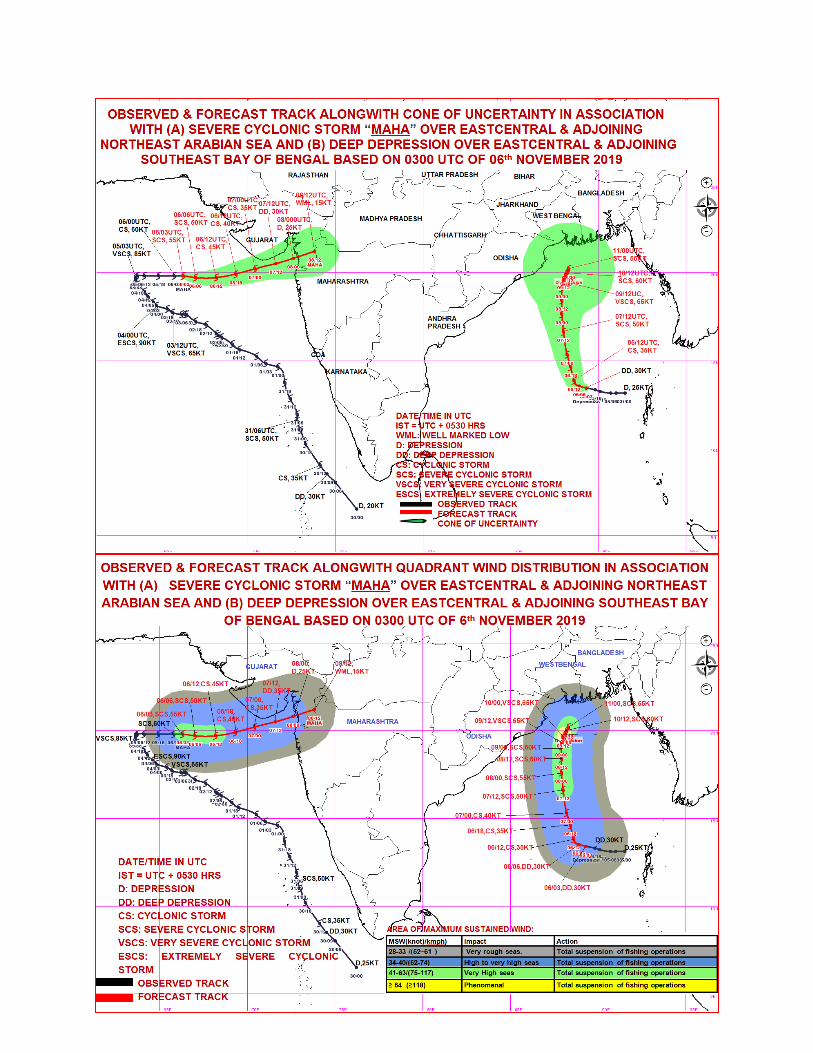
Date: 06-11-2019 The Severe Cyclonic storm MAHA (Pronounced as M’maha) over eastcentral & adjoining northeast Arabian Sea continued to move eastwards with a speed of 14 kmph during past 06 hours and lay centered at 0830 hrs IST of today, the 06th November, 2019 over eastcentral & adjoining northeast Arabian Sea near latitude 19.8°N and longitude 66.3°E, about 400 km west-southwest of Porbandar (Gujarat), 440 km west-southwest of Veraval (Gujarat) and 490 km west-southwest of Diu. It is very likely to move nearly eastwards, weaken into a Cyclonic Storm by today, the 6th November evening. Thereafter it is likely to move east-northeastwards, weaken further into a Deep Depression by early morning of tomorrow, the 7th November over northeast and adjoining eastcentral Arabian Sea. It is very likely to skirt Saurashtra coast and lie centered about 40 kilometers south of Diu around noon of 7th November as a deep depression. Continuing to move east-northeastwards, it would further weaken into a depression by tomorrow evening.
Forecast track and intensity are given in the following table: Date/Time(IST) Position
(Lat. 0N/ Long. 0E) Maximum sustained surface
wind speed (Kmph) Category of cyclonic
disturbance
06.11.19/0830 19.8/66.3 100-110 gusting to 125 Severe Cyclonic Storm
06.11.19/1130 19.7/67.0 90-100 gusting to 110 Severe Cyclonic Storm
06.11.19/1730 19.7/68.2 75-85 gusting to 95 Cyclonic Storm
06.11.19/2330 19.9/69.3 65-75 gusting to 85 Cyclonic Storm
07.11.19/0530 20.1/69.7 55-65 gusting to 75 Deep Depression
07.11.19/1730 20.3/71.6 40-50 gusting to 60 Depression
08.11.19/0530 20.6/72.6 25-35 gusting to 45 Well Marked Low
In association with the cyclonic storm ‘MAHA’, Gujarat State is very likely to experience an active wet spell during next 48 hours. The day wise forecast and warnings for the state are given below,
Date Weather Forecast for next 4 days
DAY-1 ( Valid from 0830 Hrs. IST of 06/11/2019 to 0830 Hrs. IST of 07/11/2019 )
Light to moderate rain/ thundershowers very likely at a few places in the
districts of Gujarat region namely Banaskantha, Ahmedabad, Kheda,
Anand, Vadodara, Bharuch, Surat, Navsari, Valsad and in Daman, Dadra
Nagar Haveli; at many places in all the districts of Saurashtra-Kutch. Dry
weather very likely in remaining districts of Gujarat region.
Government of India Ministry of Earth Sciences
India Meteorological Department
Meteorological Centre, RS/RW Building, Airport,
Ahmedabad-382 475.
Phone and Fax : 079-22865449
E_ mail: [email protected]
Press release
Warnings:
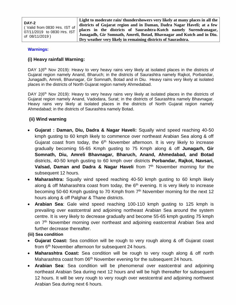
(i) Heavy rainfall Warning: DAY 1(6th Nov 2019): Heavy to very heavy rains very likely at isolated places in the districts of Gujarat region namely Anand, Bharuch; in the districts of Saurashtra namely Rajkot, Porbandar, Junagadh, Amreli, Bhavnagar, Gir Somnath, Botad and in Diu. Heavy rains very likely at isolated places in the districts of North Gujarat region namely Ahmedabad. DAY 2(6th Nov 2019): Heavy to very heavy rains very likely at isolated places in the districts of Gujarat region namely Anand, Vadodara, Surat; in the districts of Saurashtra namely Bhavnagar. Heavy rains very likely at isolated places in the districts of North Gujarat region namely
Ahmedabad; in the districts of Saurashtra namely Botad.
(ii) Wind warning
Gujarat : Daman, Diu, Dadra & Nagar Haveli: Squally wind speed reaching 40-50
kmph gusting to 60 kmph likely to commence over northeast Arabian Sea along & off
Gujarat coast from today, the 6th November afternoon. It is very likely to increase
gradually becoming 55-65 Kmph gusting to 75 Kmph along & off Junagarh, Gir
Somnath, Diu, Amreli Bhavnagar, Bharuch, Anand, Ahmedabad, and Botad
districts, 40-50 kmph gusting to 60 kmph over districts Porbandar, Rajkot, Navsari,
Valsad, Daman and Dadra & Nagar Haveli from 7th November morning for the
subsequent 12 hours.
Maharashtra: Squally wind speed reaching 40-50 kmph gusting to 60 kmph likely
along & off Maharashtra coast from today, the 6th evening. It is very likely to increase
becoming 50-60 Kmph gusting to 70 Kmph from 7th November morning for the next 12
hours along & off Palghar & Thane districts.
Arabian Sea: Gale wind speed reaching 100-110 kmph gusting to 125 kmph is
prevailing over eastcentral and adjoining northeast Arabian Sea around the system
centre. It is very likely to decrease gradually and become 55-65 kmph gusting 75 kmph
on 7th November morning over northeast and adjoining eastcentral Arabian Sea and
further decrease thereafter.
(iii) Sea condition
Gujarat Coast: Sea condition will be rough to very rough along & off Gujarat coast
from 6th November afternoon for subsequent 24 hours.
Maharashtra Coast: Sea condition will be rough to very rough along & off north
Maharashtra coast from 06th November evening for the subsequent 24 hours.
Arabian Sea: Sea condition will be phenomenal over eastcentral and adjoining
northeast Arabian Sea during next 12 hours and will be high thereafter for subsequent
12 hours. It will be very rough to very rough over westcentral and adjoining northwest
Arabian Sea during next 6 hours.
DAY-2 ( Valid from 0830 Hrs. IST of 07/11/2019 to 0830 Hrs. IST of 08/11/2019 )
Light to moderate rain/ thundershowers very likely at many places in all the
districts of Gujarat region and in Daman, Dadra Nagar Haveli; at a few
places in the districts of Saurashtra-Kutch namely Surendranagar,
Junagadh, Gir Somnath, Amreli, Botad, Bhavnagar and Kutch and in Diu.
Dry weather very likely in remaining districts of Saurashtra.

(iv) Storm Surge
Storm surge of about 0.5 meter above Astronomical tide is likely to inundate low
lying areas of Bhavnagar, Junagarh, Gir Somnath, Amreli, Surat, Bharuch,
Anand and Ahmedabad Districts from morning to forenoon of 7th November.
(v) Fishermen Warning
The fishermen are advised not to venture into westcentral and adjoining northwest Arabian
Sea during next 12 hours and over eastcentral & adjoining northeast Arabian Sea till 08th
November.
The fishermen are advised not to venture into Sea along & off Gujarat coast and adjoining
north Maharashtra coast till 8th November.
(vi) Port Warning:
Storm Warning Signals:
LOWER SIGNAL DISTANT WARNING – II (DW-II) AND HOIST SIGNAL LOCAL CAUTIONARY- III (LC-III) AT ALL PORTS OF NORTH AND SOUTH GUJARAT COASTS.
(vii) Damage Expected over coastal districts of Gujarat (Junagarh, Gir Somnath, Amreli, Bhavnagar, Surat, Bharuch, Anand, Ahmedabad, Botad, Porbandar) and Daman, Diu:
Minor damage to loose / unsecured structures. Some breaches in Kutcha road due to flooding. Minor damage to Banana trees and near coastal agriculture due to salt spray. Damage
to ripe paddy crops. Minor damage to Kutcha embankments.
5 DAYS RAINFALL FORECAST FOR THE DISTRICTS OF GUJARAT REGION, DAMAN AND DADRA NAGAR HAVELI
DATE OF ISSUE : 06-11-2019
S.NO. DISTRICT
06 NOV 07 NOV
DAY-1 (Today)
DAY-2 (Thu)
1 BANASKANTHA Light to Moderate RA/TSH(a few
places) Very Likely
Light to Moderate RA/TSH(at many places)
Very Likely
2 PATAN Dry
Very Likely
Light to Moderate RA/TSH(at many places)
Very Likely
3 MEHSANA Dry
Very Likely
Light to Moderate RA/TSH(at many places)
Very Likely
4 SABARKANTHA Dry
Very Likely
Light to Moderate RA/TSH(at many places)
Very Likely
5 GANDHINAGAR Dry
Very Likely
Light to Moderate RA/TSH(at many places)
Very Likely
6 ARAVALLI Dry
Very Likely
Light to Moderate RA/TSH(at many places)
Very Likely
7 KHEDA Light to Moderate RA/TSH(a few Light to Moderate RA/TSH(at many

places) Very Likely
places) Very Likely
8 AHMEDABAD Heavy At Isolated Places
Very Likely Heavy At Isolated Places
Very Likely
9 ANAND Heavy to Very Heavy At Isolated
Places Very Likely
Heavy to Very Heavy At Isolated Places
Very Likely
10 BARODA Light to Moderate RA/TSH(a few
places) Very Likely
Heavy to Very Heavy At Isolated Places
Very Likely
11 PANCHMAHAL Dry
Very Likely
Light to Moderate RA/TSH(at many places)
Very Likely
12 DOHAD Dry
Very Likely
Light to Moderate RA/TSH(at many places)
Very Likely
13 MAHISAGAR Dry
Very Likely
Light to Moderate RA/TSH(at many places)
Very Likely
14 CHHOTA UDAIPUR Dry
Very Likely
Light to Moderate RA/TSH(at many places)
Very Likely
15 NARMADA Dry
Very Likely
Light to Moderate RA/TSH(at many places)
Very Likely
16 BROACH Heavy to Very Heavy At Isolated
Places Very Likely
Light to Moderate RA/TSH(at many places)
Very Likely
17 SURAT Light to Moderate RA/TSH(a few
places) Very Likely
Heavy to Very Heavy At Isolated Places
Very Likely
18 DANGS Dry
Very Likely
Light to Moderate RA/TSH(at many places)
Very Likely
19 NAVSARI Light to Moderate RA/TSH(a few
places) Very Likely
Light to Moderate RA/TSH(at many places)
Very Likely
20 VALSAD Light to Moderate RA/TSH(a few
places) Very Likely
Light to Moderate RA/TSH(at many places)
Dry
21 TAPI Dry
Very Likely
Light to Moderate RA/TSH(at many places)
Very Likely
U.T DADARA NAGAR HAVELI
Light to Moderate RA/TSH(a few places)
Very Likely
Light to Moderate RA/TSH(at many places)
Very Likely
U.T DAMAN Light to Moderate RA/TSH(a few
places) Very Likely
Light to Moderate RA/TSH(at many places)
Very Likely
22 SURENDRANAGAR Light to Moderate RA/TSH(at many
places) Very Likely
Light to Moderate RA/TSH(a few places)
Very Likely
23 RAJKOT Heavy to Very Heavy At Isolated
Places Very Likely
Dry Very Likely
24 JAMNAGAR Light to Moderate RA/TSH(at many
places) Very Likely
Dry Very Likely
25 PORBANDAR Heavy to Very Heavy At Isolated
Places Very Likely
Dry Very Likely

26 JUNAGADH Heavy to Very Heavy At Isolated
Places Very Likely
Light to Moderate RA/TSH(a few places)
Very Likely
27 AMRELI Heavy to Very Heavy At Isolated
Places Very Likely
Light to Moderate RA/TSH(a few places)
Very Likely
28 BHAVNAGAR Heavy to Very Heavy At Isolated
Places Very Likely
Heavy to Very Heavy At Isolated Places
Very Likely
29 MORBI Light to Moderate RA/TSH(at many
places) Very Likely
Dry Very Likely
30 DEVBHUMI DWARKA
Light to Moderate RA/TSH(at many places)
Very Likely
Dry Very Likely
31 GIR SOMNATH Heavy to Very Heavy At Isolated
Places Very Likely
Light to Moderate RA/TSH(a few places)
Very Likely
32 BOTAD Heavy to Very Heavy At Isolated
Places Very Likely
Heavy At Isolated Places Very Likely
33 KUTCH Light to Moderate RA/TSH(at many
places) Very Likely
Light to Moderate RA/TSH(a few places)
Very Likely
U.T DIU Heavy to Very Heavy At Isolated
Places Very Likely
Light to Moderate RA/TSH(a few places)
Very Likely
(WARNING)
active Reg DIU actReg
Value ALERT actRegValue
Code _cls2w actRegCode
WS
WARNING(TAKE ACTION)
ALERT(BE PREPARED)WATCH(BE UPDATED)
NO WARNING(NO ACTION)
WARNING DAY-1Wednesday , 06 November 2019
Kutch
Jamnagar
Porbandar
Junagarh Amreli
Bhavnagar
Rajkot
Surendranagar
Ahmedabad
Gandhinagar
Banaskantha
PatanSabarkantha
Kheda Panchmahal
Dahod
Baroda
Anand
BroachNarmada
Surat
DangNavsari
Valsad
ChhotaUdaipur
MahiSagar
Aravalli
Tapi
Mahesana
BotadDevBhumiDwarka
Morbi
Gir
DIU
Daman
DDNH
active Reg DIU actReg
Value NO WARNINGactRegValue
Code _cls4w actRegCode
WS
WARNING(TAKE ACTION)
ALERT(BE PREPARED)WATCH(BE UPDATED)
NO WARNING(NO ACTION)
WARNING DAY-2Thursday , 07 November 2019
Kutch
Jamnagar
Porbandar
Junagarh Amreli
Bhavnagar
Rajkot
Surendranagar
Ahmedabad
Gandhinagar
Banaskantha
PatanSabarkantha
Kheda Panchmahal
Dahod
Baroda
Anand
BroachNarmada
Surat
DangNavsari
Valsad
ChhotaUdaipur
MahiSagar
Aravalli
Tapi
Mahesana
BotadDevBhumiDwarka
Morbi
Gir
DIU
Daman
DDNH

active Reg DIU actReg
Value NO WARNINGactRegValue
Code _cls4w actRegCode
WS
WARNING(TAKE ACTION)
ALERT(BE PREPARED)WATCH(BE UPDATED)
NO WARNING(NO ACTION)
WARNING DAY-3Friday , 08 November 2019
Kutch
Jamnagar
Porbandar
Junagarh Amreli
Bhavnagar
Rajkot
Surendranagar
Ahmedabad
Gandhinagar
Banaskantha
PatanSabarkantha
Kheda Panchmahal
Dahod
Baroda
Anand
BroachNarmada
Surat
DangNavsari
Valsad
ChhotaUdaipur
MahiSagar
Aravalli
Tapi
Mahesana
BotadDevBhumiDwarka
Morbi
Gir
DIU
Daman
DDNH
active Reg DIU actReg
Value NO WARNINGactRegValue
Code _cls4w actRegCode
WS
WARNING(TAKE ACTION)
ALERT(BE PREPARED)WATCH(BE UPDATED)
NO WARNING(NO ACTION)
WARNING DAY-4Saturday , 09 November 2019
Kutch
Jamnagar
Porbandar
Junagarh Amreli
Bhavnagar
Rajkot
Surendranagar
Ahmedabad
Gandhinagar
Banaskantha
PatanSabarkantha
Kheda Panchmahal
Dahod
Baroda
Anand
BroachNarmada
Surat
DangNavsari
Valsad
ChhotaUdaipur
MahiSagar
Aravalli
Tapi
Mahesana
BotadDevBhumiDwarka
Morbi
Gir
DIU
Daman
DDNH
active Reg DIU actReg
Value NO WARNINGactRegValue
Code _cls4w actRegCode
WS
WARNING(TAKE ACTION)
ALERT(BE PREPARED)WATCH(BE UPDATED)
NO WARNING(NO ACTION)
WARNING DAY-5Sunday , 10 November 2019
Kutch
Jamnagar
Porbandar
Junagarh Amreli
Bhavnagar
Rajkot
Surendranagar
Ahmedabad
Gandhinagar
Banaskantha
PatanSabarkantha
Kheda Panchmahal
Dahod
Baroda
Anand
BroachNarmada
Surat
DangNavsari
Valsad
ChhotaUdaipur
MahiSagar
Aravalli
Tapi
Mahesana
BotadDevBhumiDwarka
Morbi
Gir
DIU
Daman
DDNH
Legends:-
INTENSITY OF RAINFALL हिन्दी / ગુજરાતી VERY LIGHT 0.1 TO 2.4 MM बहुत हल्की वर्षा / બહુજ ઓછુ વરસાદ
LIGHT 2.5 - 15.5 MM हल्की वर्षा / ઓછો વરસાદ
MODERATE 15.6 - 64.4 MM मध्यम वर्षा / મધ્યમ વરસાદ
HEAVY 64.5 - 115.5 MM भषरी वर्षा / ભારે વરસાદ VERY HEAVY 115.6 - 204.4 MM बहुत भषरी वर्षा / ખૂબ ભારે વરસાદ
EXTREMELY HEAVY ≥ 204.5 MM अत्यधिक भषरी वर्षा / અત્યંત ભારે વરસાદ
EXCEPTIONALLY HEAVY
WHEN THE AMOUNT IS A VALUE NEAR ABOUT THE HIGHEST RECORDED RAINFALL AT OR NEAR THE STATION FOR THE
असषिषरण भषरी वर्षा / અસામાન્ય ભારે વરસાદ

MONTH OR SEASON. HOWEVER, THIS TERM WILL BE USED ONLY WHEN THE ACTUAL RAINFALL AMOUNT EXCEEDS 12 CM
PROBABILITY OF OCCURENCE (%)
हिन्दी ગજુરાતી
UNLIKELY संभषवनष नहीं શક્યતા નથી.
LIKELY संभषववत શક્યતા છે.
VERY LIKELY अधिक संभषवनष વધારે શક્યતા છે.
MOST LIKELY अत्यषधिक संभषवनष અત્યાધધક શક્યતા છે.
WARNING COLOUR CODES हिन्दी ગુજરાતી
WARNING (TAKE ACTION) चेतावनी ચતેાવણી
ALERT (BE PREPARED) सतर्क रिें સતકક રહો
WATCH (BE UPDATED) ननगरानी रखें ધ્યાન આપો
NO WARNING (NO ACTION) र्ोई चेतावनी निीीं કોઇ ચતેાવણી નથી