Embed Size (px)
Citation preview
GOVERNMENT OF INDIA
MINISTRY OF WATER RESOURCES
CENTRAL GROUND WATER BOARD
GROUND WATER INFORMATION SAWAI MADHOPUR DISTRICT
RAJASTHAN
WESTERN REGION JAIPUR 2013

i
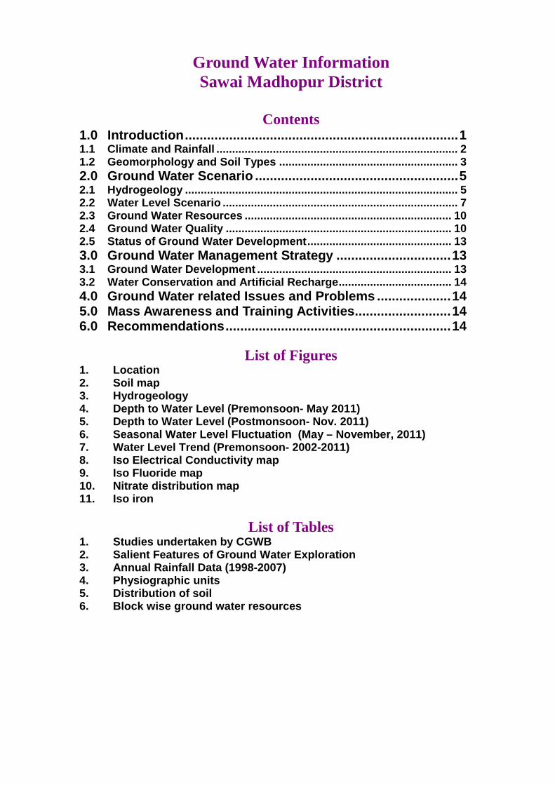
SAWAI MADHOPUR DISTRICT AT A GLANCE
1. GENERAL INFORMATION Geographical Area : 5020.65 sq. km. Administrative Divisions : Tehsils - 7; Development Block -5 Villages : 800 Population (2011) : 13,38,114
Average Annual Rainfall : 721 mm
2. GEOMORPHOLOGY Major Physiographic
unit : Alluvium, Hills
Major Drainage : Seasonal streams
3. LAND USE (2010-11) Forest Area : 79288 ha Net Area Sown : 290621ha Total Cropped Area : 412329 ha
4. SOIL TYPE : Recent Alluvial Soils, Lithosols and
Regosols of hills 5. PRINCIPAL CROPS (2010-11) Bajra : 89235ha Wheat
Jowar : :
84191ha 1942ha
Pulses Oilseeds Fruits & vegetables Condiments & spices
: : : :
22474 ha 198344 ha 12112 ha 3131 ha
6. IRRIGATION BY DIFFERENT SOURCES (2010-11)
Canals Tanks
: :
4908 ha 1366 ha
Tubewells : 75997 ha Other wells : 102719 ha Other sources : 6728 ha Net area irrigated : 191718 ha Gross area irrigated : 194484 ha
7. GROUND WATER MONITORING WELLS (As on March, 2012 ) Dugwells : 15 Piezometers : 02
8. GEOLOGY Quaternary to Recent : Alluvium Vindhyan Super Group : Sandstone, Shale& Limestone Bhilwara Super group : Quartzite, Shale, Slate, Schist, Phyllite
9. HYDROGEOLOGY Water Bearing
Formation : Alluvium; Weathered and fractured hard rocks
ii
Pre-monsoon Depth to Water Level (May-2011)
: 6 m to 49 m
Postmonsoon Depth to Water Level (Nov.-2011)
: 0.31 m to 49m
10. GROUND WATER EXPLORATION (As on 31.3.2013) Wells Drilled : EW 47, OW 5, PZ 3, SH 7 Depth Range : 21.78 – 175 mbgl Discharge : 13 – 3000 lpm Transmissivity : 2.93 – 272 m2/day
11. GROUND WATER QUALITY Major quality problems : Type of Water :
12. DYNAMIC GROUND WATER RESOURCES- (As on 31/03/2009) Net Annual Ground Water
Availability : 34624.03 ham
Annual Ground Water Draft (Irrigation+Domestic)
: 44361.49 ham
Stage of Ground Water Development
: 128%
13. AWARENESS AND TRAINING ACTIVITY A Mass Awareness
Programme : 0
B Water Management Training Programme
: 1
14. MAJOR GROUND WATER PROBLEMS AND ISSUES Over exploitation of ground water resources and ground water quality problems at places
Ground Water Information Sawai Madhopur District
Contents
1.0 Introduction....................................... ...................................1 1.1 Climate and Rainfall ............................... .............................................. 2 1.2 Geomorphology and Soil Types ....................... .................................. 3 2.0 Ground Water Scenario .............................. .........................5 2.1 Hydrogeology ....................................... ................................................ 5 2.2 Water Level Scenario ............................... ............................................ 7 2.3 Ground Water Resources ............................. ..................................... 10 2.4 Ground Water Quality ............................... ......................................... 10 2.5 Status of Ground Water Development................. ............................. 13 3.0 Ground Water Management Strategy ................... ............13 3.1 Ground Water Development ........................... ................................... 13 3.2 Water Conservation and Artificial Recharge......... ........................... 14 4.0 Ground Water related Issues and Problems ........... .........14 5.0 Mass Awareness and Training Activities............. .............14 6.0 Recommendations.................................... .........................14
List of Figures 1. Location 2. Soil map 3. Hydrogeology 4. Depth to Water Level (Premonsoon- May 2011) 5. Depth to Water Level (Postmonsoon- Nov. 2011) 6. Seasonal Water Level Fluctuation (May – Novembe r, 2011) 7. Water Level Trend (Premonsoon- 2002-2011) 8. Iso Electrical Conductivity map 9. Iso Fluoride map 10. Nitrate distribution map 11. Iso iron
List of Tables 1. Studies undertaken by CGWB 2. Salient Features of Ground Water Exploration 3. Annual Rainfall Data (1998-2007) 4. Physiographic units 5. Distribution of soil 6. Block wise ground water resources
1
Ground Water Information Sawai Madhopur District
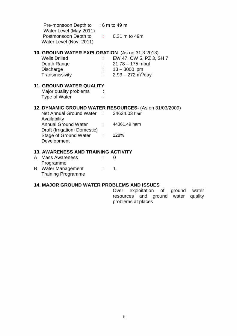
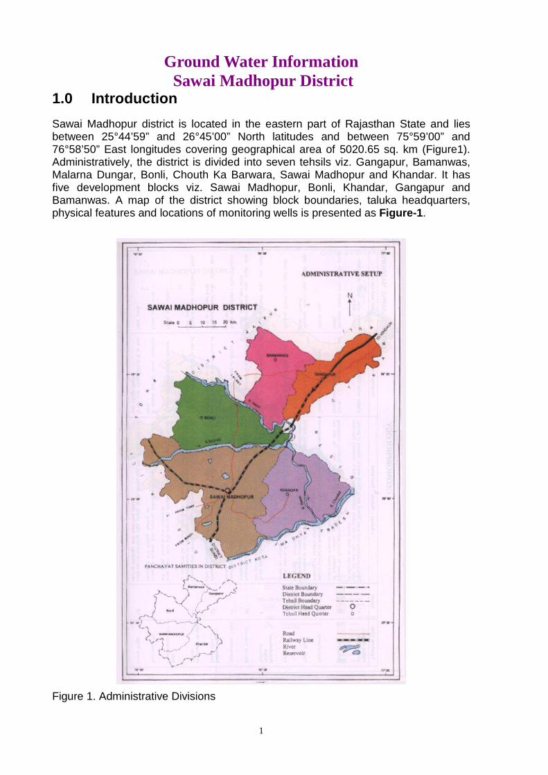
1.0 Introduction Sawai Madhopur district is located in the eastern part of Rajasthan State and lies between 25°44’59” and 26°45’00” North latitudes and between 75°59’00” and 76°58’50” East longitudes covering geographical area of 5020.65 sq. km (Figure1). Administratively, the district is divided into seven tehsils viz. Gangapur, Bamanwas, Malarna Dungar, Bonli, Chouth Ka Barwara, Sawai Madhopur and Khandar. It has five development blocks viz. Sawai Madhopur, Bonli, Khandar, Gangapur and Bamanwas. A map of the district showing block boundaries, taluka headquarters, physical features and locations of monitoring wells is presented as Figure-1 .
Figure 1. Administrative Divisions
2
Total population of the district is 1335551 (Census 2011). Out of this 19.95% of total population lives in towns and 80.05% in rural area. The population density is 297 persons per sq. km of area.
Central Ground Water Board has taken up various scientific studies in the district. A list of studies carried out in the district is given in Table 1.
Table 1: Studies undertaken by CGWB.
S. No.
Officer AAP Type of Survey/Study
1. M.Mehta 1974-75 Systematic hydrogeological survey in Banganga river basin covering parts of Jaipur, Bharatpur, Alwar, and Sawai Madhopur districts
2. D.K. Vaid, D.S.K. Rao & A.N. Lal
1977-78 Systematic hydrogeological surveys in Chambal basin in parts of Kota, Bundi, Sawai Madhopur and Tonk districts
3. S.K. Jain and S.Datta
1979-81 Systematic Hydrogeological Survey in parts of Gambhir river basin covering pafrts of Bharatpur, Dholpur and Sawai Madhopur districts
4. S.K. Gupta 1987-88 Reappraisal Hydrogeological Survey in Dausa, Baswa, Sikrai and Lalsot blocks of Jaipur and Mahuwa block of Sawai Madhopur district
5. R.L. Gupta 1991-92 Reappraisal hydrogeological survey in parts of proposed canal command area of Bisalpur project and its environ falling in Tonk, Sawai Madhopur and Bundi districts
The report on Ground Water Resources and Development Prospects in Sawai Madhopur district has been brought out by Central Ground Water Board in the year 1988. Revised report was issued in 2000. Since its inception, the Central Ground Water Board has drilled 47 Exploratory wells, 5 Observation wells, 3 piezometers and 7 slim holes in the district. Salient features of ground water exploration are listed in Table 2. Central Ground Water Board also monitors ground water levels through a network of 17 observation wells four times in a year during the months of January, May, August and November. Samples for water quality analyses are collected during May.
Table 2: Salient Features of Ground Water Exploration
Type of well
No. Depth drilled (m) SWL (m) T (m2/day) Discharge (lpm)
EC (µScm) at 25oC
EW 47 21.78 – 175 1 - 100 2.93 – 272 13 – 3000 235 – 44840 OW 5 74.55 – 160.05 11.41 – 39 40.25 25 – 1250 1110 – 1285 PZ 3 26 – 200.10 8.47 – 23.13 33.12 25 – 132 150 – 1000 SH 7 19.60 – 60.45 13.60 - 63 1000 - 3188
1.1 Climate and Rainfall The climate of the district can be classified as semi-humid. It is characterized by very hot summers and very cold winters with fairly good rainfall during south-west monsoon period. In May, the maximum temperature may sometimes reach up to 40.6oC. The potential evapotranspiration rates are quite high, especially during May and June. The total annual potential evapotranspiration is 1658.0 mm and is the highest in the month of June (220mm).
The normal annual rainfall of the district is 721 mm is slightly higher than average rainfall. The most of the rainfall is received (93.5%) during the monsoon months.
3
District is prone to mild and normal type of droughts. Probability of average annual rainfall exceeding around 1000mm is only 10%. However there is 90% probability that the average rainfall will be more than 380mm.The probability of occurrence of mean annual rainfall is about 50%.
Table 3a: Month-wise Normal Rainfall of Sawai Madhopur
District Jan Feb Mar April May Jun Jul Aug Sep Oct Nov Dec Total
Sawai
Madhopur
7.3 6.4 2.9 2.9 9.8 53.9 253.4 264.5 92.2 19.4 4.7 3.6 721.0
Table 3b: District-wise actual rainfall during 2010-2011
District Jun Jul Aug Sep Oct Nov Dec Jan Feb Mar Apr May Total
Sawai
Madhopur
19.3 165.4 320.7 185.9 0.0 115.9 2.1 0.0 16.0 0.0 0.0 4.0 829.3
Table 3b: District-wise actual seasonal rainfall during 2010-2011
District Annual
Normal
June 10 - Sep
10
Oct 10 - Dec
10
Jan 11 - Feb
11
March 11 -
May 11
Total (Jun 10
to May 11)
Alwar 630.9 760.1 29.9 44.0 21.0 855.0
(Source: Rajasthan Agricultural Statistics at a Glance, 2010-2011)
1.2 Geomorphology and Soil Types Physiographically, the district can be divided into three units as given below:
Table 4: Physiographic units in Sawai Madhopur district, Rajasthan
Sl. No. Physiographic Unit Extension 1 Hilly terrain Occupies the south and south eastern parts of district. The hills
follow a general trend of NE-SW direction starting from Jamaira in the north eastern part of the district to Odera in the south western part.
2 Alluvial plains with isolated hills
Occupies the central part of district.
3 Alluvial plains Mostly confined to the western part of district, however some northern and north western parts are also occupied by the alluvial plains.
Development of ravines with bad land topography along with Chambal river and its tributaries have a conspicuous physiographic region in the district. The surface elevation of ground ranges from 223 m amsl in the north east to about 507 m amsl in the south western part of the district.
The drainage system of the district is well developed with Chambal, Banas and Morel as main rivers and their tributaries. Chambal is the only perennial river and enters this district near village Karanpura and flows in north-easterly direction along interstate border with Madhya Pradesh. It is joined by Parbati river near village Pali. Other two main non-perennial rivers are Banas flowing from west to east through the central part of the district and then turning in south direction joining Chambal river and the Morel river flowing from north west to south east direction joining Banas river.
Drainage in the rocky terrain is sub-parallel type while in plain area, it is dendritic type. The drainage density in the district increases gradually towards south. The drainage density around Bamanwas and Malarna Dungar ranges from 0.30 to 0.50
4
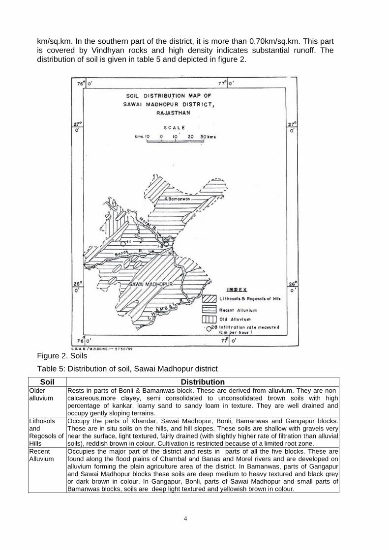
km/sq.km. In the southern part of the district, it is more than 0.70km/sq.km. This part is covered by Vindhyan rocks and high density indicates substantial runoff. The distribution of soil is given in table 5 and depicted in figure 2.
Figure 2. Soils
Table 5: Distribution of soil, Sawai Madhopur district
Soil Distribution Older alluvium
Rests in parts of Bonli & Bamanwas block. These are derived from alluvium. They are non-calcareous,more clayey, semi consolidated to unconsolidated brown soils with high percentage of kankar, loamy sand to sandy loam in texture. They are well drained and occupy gently sloping terrains.
Lithosols and Regosols of Hills
Occupy the parts of Khandar, Sawai Madhopur, Bonli, Bamanwas and Gangapur blocks. These are in situ soils on the hills, and hill slopes. These soils are shallow with gravels very near the surface, light textured, fairly drained (with slightly higher rate of filtration than alluvial soils), reddish brown in colour. Cultivation is restricted because of a limited root zone.
Recent Alluvium
Occupies the major part of the district and rests in parts of all the five blocks. These are found along the flood plains of Chambal and Banas and Morel rivers and are developed on alluvium forming the plain agriculture area of the district. In Bamanwas, parts of Gangapur and Sawai Madhopur blocks these soils are deep medium to heavy textured and black grey or dark brown in colour. In Gangapur, Bonli, parts of Sawai Madhopur and small parts of Bamanwas blocks, soils are deep light textured and yellowish brown in colour.

5
2.0 Ground Water Scenario
2.1 Hydrogeology Ground water occurs both in unconsolidated and consolidated formations of the district (Figure 3). A map depicting hydrogeological formations in Sawai Madhopur district is presented as Figure-3 .
Figure 3. Hydrogeology of Sawai Madhopur district
2.1.1 Consolidated formation Consolidated formations including schist, phyllite, shale, slate and quartzite of Bhilwara Super Group; sandstone, shale and limestone of Vindhyan Super Group;

6
and quartzite, schist and gneiss of Delhi Super Group covering about 60% of district form the principal aquifer in the district. Ground water occurs under unconfined condition in weathered and fractured portions of the consolidated formations. These form generally poorer aquifer than alluvium and are tapped by open wells, dug cum bore wells, and bore wells. Ground water condition in various formations is described in the following paragraphs.
Schists and gneisses Mica schist forms an important aquifer in Sawai Madhopur and Bonli blocks. The thickness of weathered zone is more compared to gneisses but the yield of wells is poor as the weathered product is mainly clayey. Yield of dug wells varies from 40 to 100 m3/day. Intrusives of pegmatite and quartz veins in the country rock increase the yield of the wells and recuperation is fast.
Phyllites and slates These form aquifer in limited area lying south west of Sawai Madhopur. The depth of weathering ranges from 2 to 3 m and fractured zone generally extends down to 10 m depth. Yield of wells depends upon the thickness of weathered zone. Yield of wells tapping this formation ranges from 20 to 300 m3/day. Recupeartion is faster than mica schist. Around Pachala west of Sawai Madhopur, the phyllite is main water bearing unit.
Quartzite Quartzite forms aquifer in the southwestern part of Sawai Madhopur and is highly fractured and jointed. Inter-bedding of slates and phyllites is common with the formation. The thickness of fractured zone extends from 2 to 14 m. Thickness of weathered zone is not significant.
Dolomitic limestone This forms aquifer in a small area to the west of Sawai Madhopur and is overlain by 2 to 4m thick zone of calcareous clay. The yield of wells ranges from 30 to 120m3/day.
Vindhyan shale Vindhyan shales form aquifer in extreme southern and south eastern parts of the district. These are intercalated with thin layers of calcareous matter. The shales are highly fractured and splintery in nature. Weathered and fractured zone extends from 2 to 17m in thickness and yield of dug wells varies from 20 to 350m3/day.
Vindhyan limestone In a small area around Malarna Dungar in Bonli block, limestone forms aquifer although it is devoid of karst structure. Yield of dug wells tapping this formation ranges from 10 to 40 m3/day.
Vindhyan sandstone Sandstone forms the most prominent aquifer after alluvium in the areal extent. It occurs in south eastern and eastern parts of the district. Bhander sandstone occurs as aquifer in southern and eastern part of the district around Bhankri, Machilpur and Langra. This is also resistant to weathering and has two sets of joints. Ground water occurs under unconfined condition. Yield of wells ranges from 15 to 145m3/day.
2.1.2 Unconsolidated formation Ground water occurs under unconfined to confined conditions in unconsolidated formation (alluvium of Quaternary age) which is tapped through various ground water abstraction structures viz. dug well, dug cum borewell and tube well.
Alluvium forms aquifer in large part of the area lying in central, northern and north western parts of the district and in area along the Chambal river in south eastern part
7
of the district. It consists of gravel, sand, silt, clay and kankar. Out of these, sand, clay and silty clay with kankar form the most dominating constituent which generally occur in upper zone and are being tapped by dug wells. Gravels generally occur at depth near the basement and these too generally do not form continuous layer. Alluvium forms most important aquifer which is being tapped by dug wells, dug cum borewells and tube wells. Ground water occurs under unconfined, semi-confined and confined conditions in these formations. The yield of dug wells varies from 50 to 150 m3/day.
2.2 Water Level Scenario Central Ground Water Board periodically monitors the National Hydrograph Network Stations (NHNS) stations in the Sawai Madhopur district, four times a year i.e. in January, May (Pre-monsoon), August and November (Post monsoon). The total number of hydrograph stations in the district is 17 comprising of 15 dug wells and 2 piezometers.
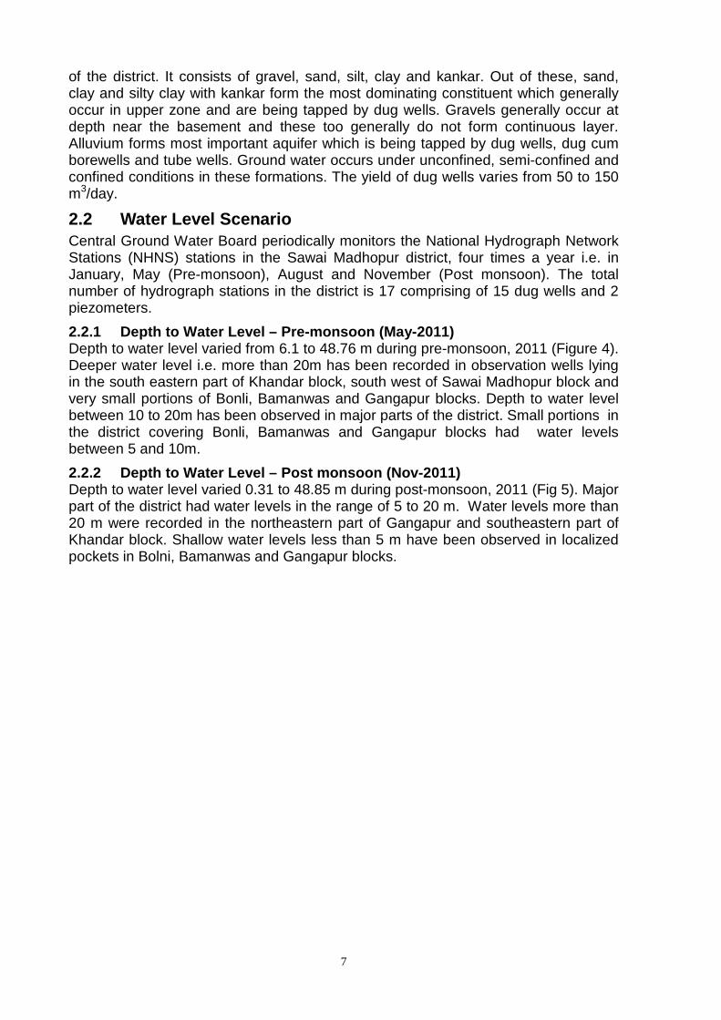
2.2.1 Depth to Water Level – Pre-monsoon (May-2011) Depth to water level varied from 6.1 to 48.76 m during pre-monsoon, 2011 (Figure 4). Deeper water level i.e. more than 20m has been recorded in observation wells lying in the south eastern part of Khandar block, south west of Sawai Madhopur block and very small portions of Bonli, Bamanwas and Gangapur blocks. Depth to water level between 10 to 20m has been observed in major parts of the district. Small portions in the district covering Bonli, Bamanwas and Gangapur blocks had water levels between 5 and 10m.
2.2.2 Depth to Water Level – Post monsoon (Nov-2011 ) Depth to water level varied 0.31 to 48.85 m during post-monsoon, 2011 (Fig 5). Major part of the district had water levels in the range of 5 to 20 m. Water levels more than 20 m were recorded in the northeastern part of Gangapur and southeastern part of Khandar block. Shallow water levels less than 5 m have been observed in localized pockets in Bolni, Bamanwas and Gangapur blocks.
8
Figure 4. Depth to Water Level during pre-monsoon (May, 2011)
Figure 5. Depth to water level map during post-monsoon (November, 2011)
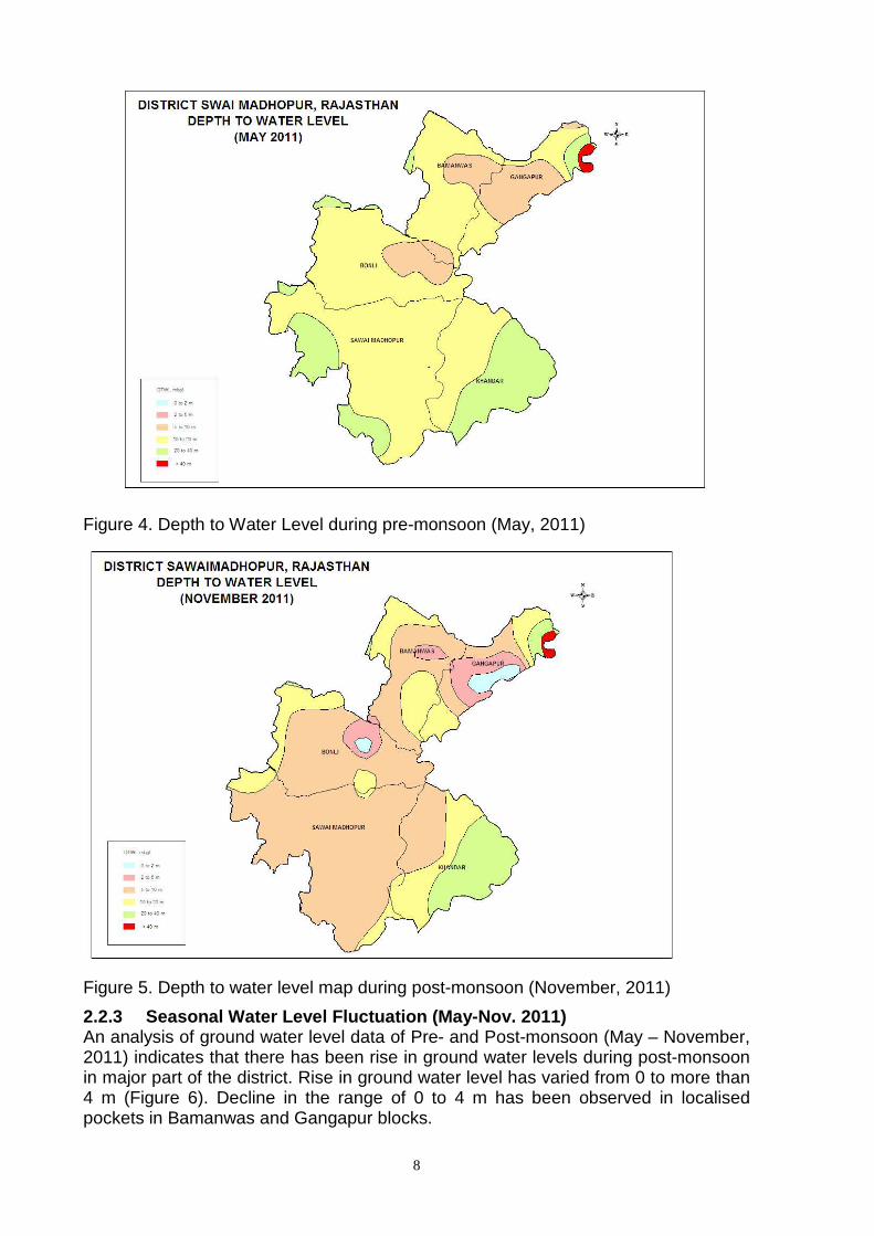
2.2.3 Seasonal Water Level Fluctuation (May-Nov. 20 11) An analysis of ground water level data of Pre- and Post-monsoon (May – November, 2011) indicates that there has been rise in ground water levels during post-monsoon in major part of the district. Rise in ground water level has varied from 0 to more than 4 m (Figure 6). Decline in the range of 0 to 4 m has been observed in localised pockets in Bamanwas and Gangapur blocks.
9
Figure 6. Water level fluctuation map (May 2011 - November 2011)
2.2.4 Water Level Trend (2002-11) The premonsoon trend map was also prepared and the same is presented in Figure 7. A perusal of the map indicates rising trend of upto 25 cm/year in major parts of Sawai Madhopur and Khandar blocks and localised pockets in Bonli, Bamanwas and Gangapur blcoks. Declining trend of upto 25 cm/year has been observed in major parts of Bonli, Bamanwas and Gangapur blocks and southeastern part of Sawai Madhopur block and northern part of Khandar block.
Figure 7. Decadal Pre-monsoon water level trend map (2002 – 2011)

10
2.3 Ground Water Resources Central Ground Water Board and Ground Water Department, Government of Rajasthan have jointly estimated the ground water resources of Sawai Madhiopur district based on GEC-97 methodology. The same are presented in Table 6. Total annual ground water resources and net annual ground water availability in the district have been estimated as 382.07 mcm and 366.37 mcm respectively. Annual ground water draft for all uses in the district has been assessed to be 443.61 mcm with overall stage of ground water development at 128%. Out of five blocks, four blocks fall under ‘Over-exploited’ category and one block is ‘Critical’.
Table 6: Block wise Ground Water Resources of Sawai Madhopur (March 2009)
(in mcm) Block Annual
Replenishable
Ground Water
Resources
Net Annual Ground Water
Availability
Existing Gross
Ground Water
Draft for Irrigation
Existing Gross
Ground Water
Draft for Dom.&
Industrial Use
Existing Gross
Ground Water
Draft for All Uses
Stage of Ground Water
Development (%)
Category
Bamanwas 60.9951 54.8956 63.1284 7.9266 71.0550 129 OE Bonli 68.7343 62.7109 52.6128 14.0116 66.6244 106 OE Gangapur 63.4050 57.8099 87.0178 19.2056 106.2234 184 OE Khandar 91.7055 83.3144 69.9900 11.6538 81.6438 98 CRITICAL S.Madhopur 97.2326 87.5094 93.6192 24.4491 118.0683 135 OE
Total 382.0726 346.2403 366.3682 77.2467 443.6149 128 OE
2.4 Ground Water Quality In general, quality of ground water is suitable for irrigation and domestic uses. Shallow ground water in the district is alkaline in nature with pH varying from 7.25 to 8.24.
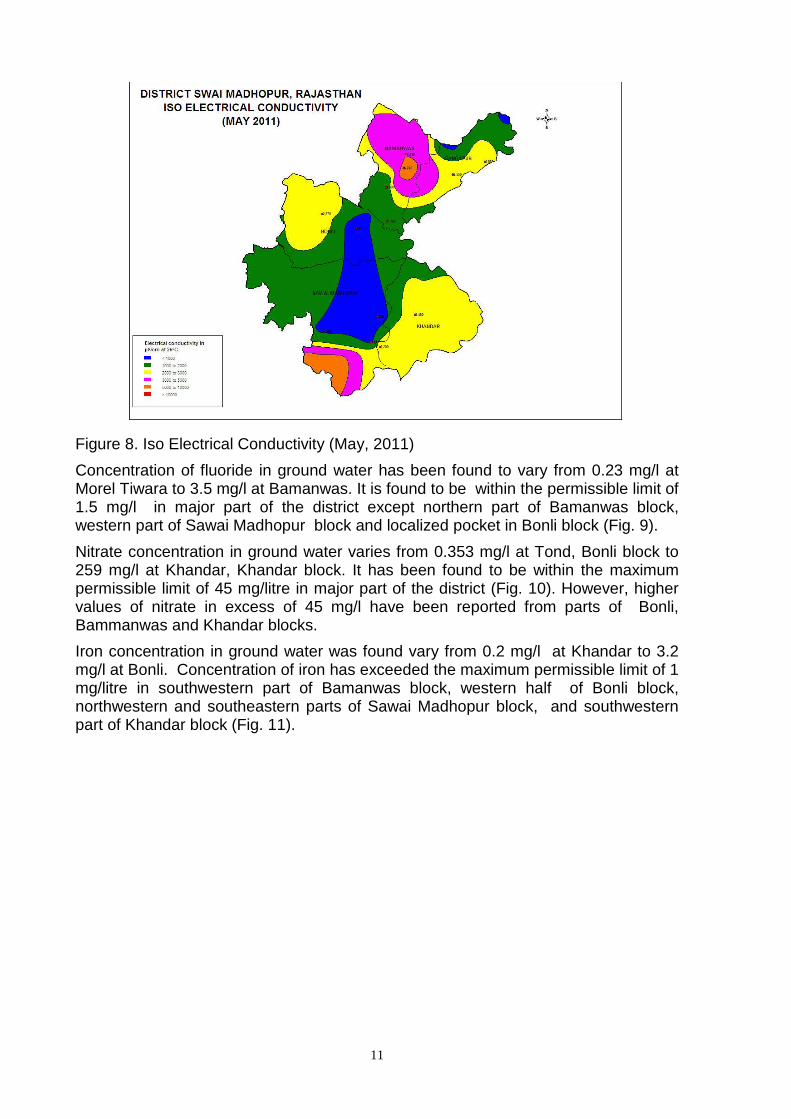
Electrical Conductivity varies from 587 µS/cm at 25oC at Malarna Chor, Bonli block to 57600 µS/cm at 25oC at Piplai. Electrical Conductivity in major part of the district is below 3000 µS/cm at 25oC (Fig. 8). Higher values of EC have been observed from southern part of Sawai Madhopur block and northern half of Bamanwas block. Chloride concentration varies from 28 mg/l at Ranthambore to 1314 mg/l at Piplai.
11
Figure 8. Iso Electrical Conductivity (May, 2011)
Concentration of fluoride in ground water has been found to vary from 0.23 mg/l at Morel Tiwara to 3.5 mg/l at Bamanwas. It is found to be within the permissible limit of 1.5 mg/l in major part of the district except northern part of Bamanwas block, western part of Sawai Madhopur block and localized pocket in Bonli block (Fig. 9).
Nitrate concentration in ground water varies from 0.353 mg/l at Tond, Bonli block to 259 mg/l at Khandar, Khandar block. It has been found to be within the maximum permissible limit of 45 mg/litre in major part of the district (Fig. 10). However, higher values of nitrate in excess of 45 mg/l have been reported from parts of Bonli, Bammanwas and Khandar blocks.
Iron concentration in ground water was found vary from 0.2 mg/l at Khandar to 3.2 mg/l at Bonli. Concentration of iron has exceeded the maximum permissible limit of 1 mg/litre in southwestern part of Bamanwas block, western half of Bonli block, northwestern and southeastern parts of Sawai Madhopur block, and southwestern part of Khandar block (Fig. 11).

12
Figure 9: Iso Fluoride (May, 2011)
Figure 10: Nitrate distribution (May, 2011)

13
Figure 11: Iso Iron (May, 2011)
Overall, the ground water quality in the wells monitored is good for irrigation purpose and there is a less possibility of developing sodium hazard.
2.5 Status of Ground Water Development The stage of ground water development for the district is 128%. Out of total 5 blocks, four blocks viz. Bamanwas, Bonli, Gangapur and Sawai Madhopur have stage of ground water development more than 100% and fall under over-exploited category. No recommendation is extended for additional ground water development except for drinking purposes.
3.0 Ground Water Management Strategy Ground water should be used judiciously by cultivating crops requiring less watering and use of sprinkler and drip irrigation systems should be encouraged. A modern agriculture management has to be taken into account for effective water management techniques involving economic distribution of water, maintaining minimum pumping hours and also by selecting the most suitable cost effective cropping pattern i.e. for getting maximum agriculture production through minimum withdrawal. Adopting proper soil and water management even using ground water with somewhat dissolved solids (TDS) may also be suitable for irrigation for growing salt tolerant crops in the area having high salinity.
3.1 Ground Water Development Stage of ground water development in four blocks in the district has exceeded 100%, which indicates that the scope of ground water development is already exhausted in these blocks and the blocks have been categorized as “Over-exploited”. There is no scope for further development in the district for irrigation or industrial use. However, exploratory drilling can be taken up in unexplored area for estimation of aquifer parameters. There is need to control and regulate ground water development in all the blocks in the district. Due caution is to be exercised in further development of ground water in Khandar block, where stage of ground water development has reached 98 % and the block is categorized as ‘Critical’.
14
3.2 Water Conservation and Artificial Recharge Northern part of the district is underlain by unsaturated moderate thickness of alluvium which provides sufficient scope for artificial recharge to ground water body as alluvial formation has very good storage and transmission capacity. In alluvial area, following ways of recharge techniques may be adopted:
• Roof top/paved area rain water harvesting for recharge to ground water in urban and industrial area.
• Village water runoff/roof top rain water harvesting by dug wells/percolation tanks in rural area.
• Construction of recharge shafts with gabion structures in nalas. • Recharge by dug well/percolation pit in agriculture farms.
In hard rock terrain, nala bunding, anicuts, dug wells, percolation tanks etc. are feasible structures which may be used to recharge the ground water body. These will certainly enhance the recharge to ground water body resulting in arrest of decline in water level.
Mass awareness programmes should be arranged at local level to make common people aware of importance of ground water resources, its better practices of use in domestic, irrigation and industrial sectors, present status of ground water scenario, need and ways of its conservation etc.
4.0 Ground Water related Issues and Problems Long term water level data (pre monsoon 2002-2011) have indicated declining water level trend in major part of the district. Four blocks in the district fall under Over exploited category, which necessitates regulation and control of ground water withdrawals through notification of blocks and further imposing ban on construction of ground water abstraction structures except under indispensable cases.
Bamanwas block is affected by ground water quality problems like salinity ,fluoride and nitrate. Salinity, fluoride and iron problems have been reported from Sawai Madhopur block. Bonli block is affected by problem of fluoride, nitrate and iron contamination in ground water.
5.0 Mass Awareness and Training Activities Central Ground Water Board organizes Water management Training Programmes at local level for central/ State agencies, NGOs, institutions etc. for capacity building to adopt various techniques of artificial recharge to ground water through rain water harvesting and surplus canal water, if available. One such training programme was organized at Sawai Madhopur on 19-20 March, 2009.
6.0 Recommendations • Ground water draft is very high in all the blocks. Stage of ground water
development in the district has reached 128% due to indiscriminate use. It has to be controlled by preventing further development.
• Revival of traditional rainwater storage system i.e. Baori, open wells, tanka etc. for rainwater conservation for use in day to day life will reduce ground water draft.
• Awareness programme on rainwater harvesting will be beneficial to check decline in water level and justified use.
• Taking advantage of uneven topography of the hard rock area small water harvesting system or earthen dams, up streams of irrigation commands at suitable sites may be constructed to store rainwater. This will increase recharge of ground water which ultimately results in increase yield of wells.

15
• Modern agriculture management techniques have to be adopted and optimum utilization of the water resource
• High water requirement crops should be discouraged. Proper agricultural extension services should be provided to the farmers so that they can go for alternate low water requirement economical crops.