Embed Size (px)
Citation preview

GNSS (GPS) buoy array in the
Pacific for natural disaster mitigation
Teruyuki KATO
Earthquake Research Institute
the University of Tokyo, Japan 1

(Modified from Oki & Koketsu, 2011)
2004 Sumatra EQ(Mw9.0)
2011 Off Tohoku EQ(Mw9.0)
1952 Kamchatka EQ(Mw9.0)
1957 Andreanov EQ(Mw9.1)
1964 Alaska EQ(Mw9.2)
2010 Central Chile EQ(Mw8.8)
1960 Chile EQ(Mw9.5)
Historical megaquakes occur only along the subducting plate boundaries.
And these earthquakes generate large tsunamis

Tsunami early warning for distant earthquake is provided through
Pacific Tsunami Warning Center, Hawaii
3

Plate boundary in the south Pacific
4
Plate velocities are shown in mm/yr
(Figure taken from web by Y. Ishikawa)

65 M>7.0 earthquakes
in the south Pacific region (2000-2016)
5
USGS

Recent significant tsunami earthquakes
in the south Pacific region
Solomon Islands M7.6 (13 Apr. 2014) &
M7.5(19 Apr. 2014)
Solomon Islands M8.0 (6 Feb. 2013)
Vanuatu M7.8 & Santa Cruz Is. M7.7(7 Oct.,
2009)
Samoa Islands Mw8.0 (29 Sep. 2009)
Solomon Islands Mw8.1 (1 Apr. 2007)
6

Countermeasures for natural disaster is a key for
SDG in the countries in this region
Earthquake and tsunami is one sample among other natural disasters.
Monitoring environmental parameters are fundamental for natural disaster mitigation – Temperature, pressure, rainfall, wind : typhoon etc.
– Seismic waves, crustal deformations: earthquake
– Sea-surface variations: sea-level rise, tsunamis
– Total electron content: ionospheric disturbance
These observations have been done mostly at on shore sites but data should be taken off shore as well for better early warning against natural disaster
GNSS buoy is a solution for this problem, in particular in the ocean
7
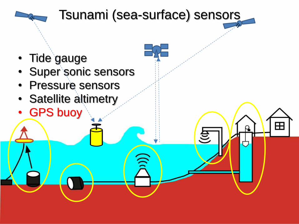
Tsunami (sea-surface) sensors
• Tide gauge • Super sonic sensors • Pressure sensors • Satellite altimetry • GPS buoy

Basic concept of sea-surface monitoring
using GNSS (GPS) buoy
Base
Station
Data
GPS Satellite
GPS Tsunami
Meter
9
RTK-GPS in baseline mode was implemented
Distance limit: less than 20km

GPS buoy for operational test off
Ofunato, northeastern Japan
1.6km
φ:2.8m H:8.2m Weight:12ton
Water depth:50m
2003Tokachi
Data were transmitted
to the City Hall and
Fire station
2001-2004
10

Peru Earthquake JST25/06/2001
Original 1Hz sampled data
11

Tsunami
Tide Gauge
GPS Buoy
Peru Earthquake JST25/06/2001
Filtered buoy data and tide gauge data
25 June 2001 (JST) 12

GPS buoys implemented as “wave meter” operated as a national wave monitor system NOWPHAS
• System uses RTK-GPS and data transmission by radio.
• Placed within 20km from the coast.
• Established at 15 sites as of 2012.
• Real time monitor on the Web is available.
(From ERI HP)
13

Observed tsunamis due to the Tohoku-Oki earthquake on 11th March 2011 by GPS buoys
Off North Iwate (Kuji)
Off Central Iwate (miyako)
Off South Iwate (Kamaishi)
EQ:14h46m
(Courtesy of Port and Airport Research Institute) 14
14:50 First tsunami alert by Japan Met. Agency (Miyagi 6m; Iwate 3m)
15:10 Acute sea-level rise was observed at JMA
15:14 Tsunami alert was updated to higher than 10m at Miyagi & 6m at Iwate
15:18 First very large tsunami arrived at Iwate

Lessons from the 11 March Tohoku-oki
tsunami and their countermeasures
GPS buoy should be placed much farther offshore for effective early warning (>100km)
Problems to be solved for far-offshore buoy deployments
1. Baseline mode kinematic observation has distance limit for accurate measurements (<20km).
– New algorithm of Precise Point Positioning should be introduced
2. Surface radio system is not adequate for long distance data transmission
– Data transmission via satellite is needed
15

Conventional PPP uses only IGS orbits/clock.
New PPP-AR uses corrections by GEONET data
GPS
receiver
IGS
(International GNSS Service)
Control
station 1Hz data
GEONET
New algorithm: PPP-AR (Precise Point Positioning with Ambiguity Resolution)
GPS satellite
T15,O48
Precise orbit
(sat. orbit and clock) Precise orbit
(sat. orbit and clock
+ correction by GEONET)
16

Experiments with QZSS & ETS-VIII
➣Period of experiments 16 Dec. 2013 – 5 Jan., 2014
1 - 15 Jun., 2014
➣Purpose
- Correction data transmission using LEX/QZSS
- Positioning data transmission via ETS-VIII.
- Real-time data dissemination through internet
(Michibiki) (Kiku 8)
17

Experiments with QZSS & ETS-VIII
18

Multi-purpose GNSS buoy for disaster mitigation
• More effective tsunami early warning at far offshore
• Ocean bottom crustal movements – Continuous monitoring by
GPS/Acoustic system
• Atmospheric research (GPS meteorology) – Contribution to weather
forecast
• Ionospheric research – Contribution to space
weather forecast
• Ocean surface monitoring with ancillary equips
• High speed satellite
communication is required
19

GPS satellites
Kinematic GPS
GPS base station
Acoustic ranging
Ocean bottom stations
Survey vessel
Slides provided by Mariko Sato (Japan Coast Guard)
Ocean bottom crustal movement observation using GPS/Acoustic system
20

Velocity of ocean bottom stations before the 3.11 Eq.
(Japan Coast Guard, File submitted to the Earthquake Research Committee)
Velocity by GPS-acoustic system
Velocity by GEONET

GNSS sat.
GPS buoy
Sending
sonic wave
Receiving
sonic wave
Internet
Kochi N. C.
Ocean bottom station (3 sets)
22
Application to ocean bottom crustal movements monitoring using GNSS buoy
Comm. Sat.
Receiving
site Users
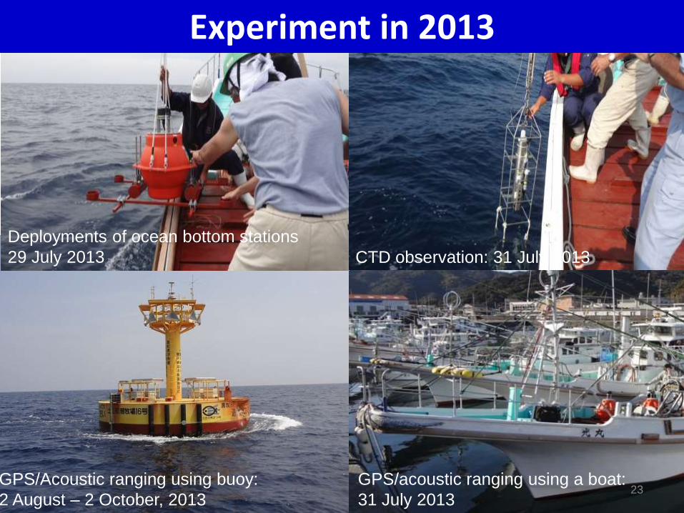
Experiment in 2013
Deployments of ocean bottom stations
29 July 2013 CTD observation: 31 July 2013
GPS/acoustic ranging using a boat:
31 July 2013
GPS/Acoustic ranging using buoy:
2 August – 2 October, 2013 23

Application of GNSS buoy for weather forecast (Meteorological Research Institute, Japan)
(Y. Shoji:Spring Meeting of MSJ 2010)
GPS buoy and GEONET sites Time series of ZTD between GEONET(1121) and buoy
Comparison is made between buoy and the GEONET site of the lowest height nearby the buoy.
Data period: 1-16 August 2008
Time series at the buoy (●) is generally consistent with that on the ground (●), yet the former differs
from the latter at some time periods.
More satellite number provides better
agreement between the two, implying
adding satellites other than GPS, such
as GLONASS, may improve the
results.
10 satellites 6 satellites 24

(translated from the slide by Tsugawa, NICT)
TEC variation observed
at the 2011 Tohoku earthquake by NICT
TEC variation observed using GEONET data. Short period variations with less than 10 minutes of
periods are shown. X indicates ionospheric epicenter. Concentric circle is centered at the
ionospheric epicenter. Cut-off elevation angle is 15deg. 25

Global ground-based GNSS network
- Next step to the oceanic region – (National Institute of Information and Communications Technology, NICT, Japan)
• More than 5,000 ground-based GNSS sites data are available online as of Jan. 2012,
over the world.
• More distributed GNSS sites in the ocean, together with more GNSS satellites,
improves spatial resolution and decreases blank area.
(translated from the slide by Tsugawa, NICT)
26

Proposed GNSS buoy array in the western Pacific
(81 sites in the Japanese EEZ; Modified from Tsugawa et al., 2012)
Expected cost for 81 sites:
(Very coarse!)
Construction 300million$
Operation 10million$/yr
Feasible? or Not?
27

Outlook for sustainable development in the Pacific countries by GNSS buoy array
• Society resilient against natural disaster is a key for development of a country
• GNSS buoy array around island country is a powerful tool for making a strong country against natural disaster, as well as monitoring sea level rise due to global warming.
• Japan has a technology of GNSS buoy for natural disaster reduction for contributing to Pacific island countries
• Further, GNSS buoy array can be a fundamental social infrastructure for monitoring earth; ocean bottom crustal deformation, ocean surface, atmosphere, ionosphere…., which is important for maritime industry, fishery, maritime traffic, etc., which will make coastal people more intelligent on the nature and more happy. 28

29