Embed Size (px)
Citation preview

Glossary of Geological Terms
_______________________________________________________________________
Carbonate Rock Types:The pure carbonate rocks are composed of varying admixtures of particles and matrix.Local production of carbonate particles eliminates effective use of grain size and sortingas significant factors as defining features in the vast majority of cases. Therefore, theclassification, organization and emphasis of rock types are based dominantly upon therelative abundance of particles and their packing. (Dunham, R. J. 1960), as follows:
Mudstone - Mud supported, with less than 10% particlesWackestone - Mud supported, with more than 10% particlesPackstone - Particles supported, with more than 10% mudGrainstone - Particles supported, with less than 10% mud
Ooids - A spherical or subspherical rock particle, which has grown by accretion around anucleus. The nucleus may be inorganic (e.g. sand grain). Their formation depends uponthe nuclei being constantly agitated, so that the calcareous material is uniformlydeposited. (oolitic)
Peloids - Are large ooids, about the size of a garden pea (3-6 mm in diameter). Algaecommonly play a significant role in their formation (pelitic).
Bioturbated - Is the reworking of sediments through the various burrowing, boring, andsediment ingesting activities of organisms. Borers such as algae, mollusks, and echinoidsare capable of penetrating hard surfaces. Burrowers such as shrimp, anemones andpolychaete worms are capable of excavating unconsolidated particles and Browsers, suchas sea cucumbers and gastropods ingest sediment in a nonselective manner and extractnutrients from the substrate.
Benthonic - Those animals that live on the sediments on the sea floor, including bothmobile and non-mobile forms. The free living (mobile) forms move to their food,whereas the sessile (non-mobile) forms, which may or may not be fixed, wait for theirfood to come to them. The characteristic of the second group is radial symmetry andcomplex food gathering organs e.g. Echinodermata: Crinoids (generally fixed), SeaUrchins, Sea Cucumbers, Star Fish, and Brittle Stars.
Facies - The sum total of features of a given environment, which are characteristic of thatenvironment, such as rock type, fossil assemblages and fauna. Facies, which areparticularly characterized by their rock type, are referred to as lithofacies, whereas thoseespecially characterized by their fauna are called biofacies.
Xerophytes - Are plants that structurally adapted for life and growth with a limited watersupply. These plants have developed mechanisms that limit transpiration, or provide forthe storage of water.

Hydric - Soil that is wet enough to periodically produce anaerobic conditions, therebyinfluencing the growth of plants.
Hydrophytic - Any plant growing in water or on a substrate that is at least periodicallydeficient in oxygen as a result of excessive water content.
Karst topography is a three-dimensional landscape shaped by the dissolution of a solublelayer or layers of bedrock, usually carbonate rock such as limestone or dolomite.
Epikarst – the upper surface of karst, consisting of a network of intersectingfissures and cavities that collect and transport surface water and nutrients.
Source KES 2007

Litho-facies Characteristics Community
(Biofacies)
Coralgal
Source: Sedimentary Environments and Facies. (Reading., 1979)
Habitat
Millepora.
Oolite
Reef (outer reef of shelf margin)
High diversity community including about 30 coral species: coral frames bound by coralline algae. Niches in frame colonized by mollusks, echinoids, foraminereans, hydrocorrallines, annelids, alcyonariains and fish. Spur and groove development. Optimum growth conditions extend from 1 m to 50 m depth. Comprises the windward reefs in the Bahamas.
Plexaurid
Aeropora palmata
Strombus samba
Oolite andGrape-stone
Occurs in back-reef areas, local patch reefs attached to rock bottom covered by blanket of ephemeral lime-sand. Corals (eg Montastrea and Diploria ) with gorgonaceans and plexaurid sea-whips. Biota dominated by strongly cemented and encrusting species.
Rock pavement
Inshore rocky shoreline
Areally restricted and strongly zoned. Dominated by cemented or closely attached biota and includes green algae, coralline algae, sponges barnacles, chitons, gastopods, bivalves, and echinoids. Rather variable depending on tidal range and degree of exposure.
Littorina
Rock ledgesandprominences
Subtidal rock ledges along exposed shorelines. Transitional with Plexaurid community. Many mollusks from the reef and rocky shoreline are found here. Corals include rock pavement species plus the hydrozoan Millepora. Mostly attached and encrusting species.
Subtidal unstable sand
Found on the outer Bank margin and immediate back reef area. Lime sand only partially stabilized by marine grasses. Bottom is rippled and there is much sediment movement, providing a high stress habitat. The conch Strombus , burrowing bivalves and sand-dollars are the typical fauna
Vegetation-stabilized sand
Strombus costatus
Is the most widespread habitat with the most diverse biota. The community develops in the sheltered waters of the back-reef and open lagoonal areas adjacent to the Bank edge. There is about 89% of non-skeletal sand grains in the oolitic facies and about 83% in the grapestone facies. These grains are composed of feacal pellets, mud aggregates, grapestone, and ooids. Green and red algae are common, mollusks are abundant (especially burrowers). Stabilization is either by algae or grass.
Contemporary oolite is forming and the facies contains about 90% of ooids. These sand shoals provide extremely mobile and grass-free habitats that are localized to actively growing intertidal oolite bars. Almost devoid of biota apart from active burrowing clam Tivela.
Intertidal, bank-edge unstable oolite
Tivela abaconis
Mud and Pellet Mud
Muddy-sand with normal to hyper- salinities
Located away from the shelf edge and transitional to the muddy shorelines and tidal flats. It is transitional between S. costatus and a euryhaline mangrove association. Members of the biota include green algae, grasses, the bryzoan Schizoporella, a coral (Manicina) , a few echinoids, mollusks. and Didemnum, a tunicate.
Didemnum
Subtidal variable salinity, muddy bottom
Occurs nearshore with a low-diversity salinity-tolerant biota, in areas receiving rain water runoff. The mollusk Ceritidea and Pseudocyrena are present with the non-calcareous alga Batophora, and miliolid and peneroplid foraminiferans.
Ceritideacostata
Intertidal and supratidal mangrove association
Muddy intertidal shorelines and supratidal flat are colonized by red and black mangrove ( Rhizophora mangle and Avicenna nitida). Sheltered marshes, mud flats and lagoonal shores support this community. The sediments are stromatolitic and rich in grazing gastropods, Fasciolaria and Batillaria.
Fasciolaria -Batillaria.
Table 4-1 Facies Composition and Distribution in the Bahama Banks
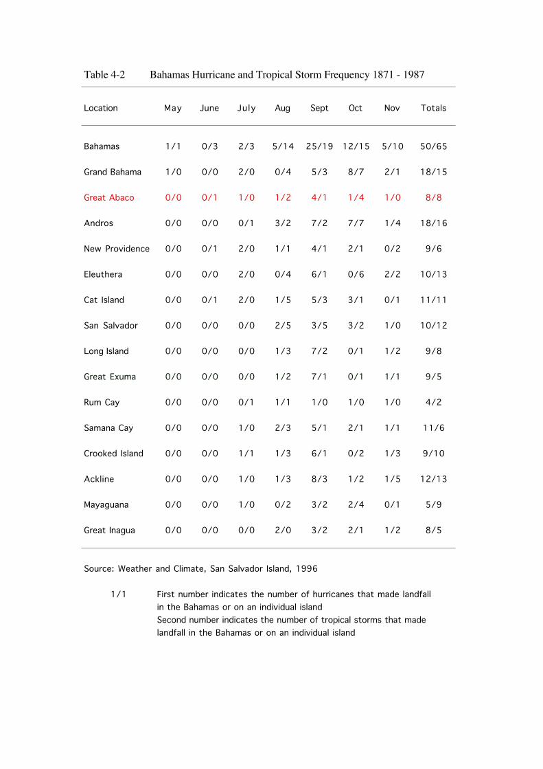
Location May June July Aug Sept Oct Nov Totals
Bahamas 1/1 0/3 2/3 5/14 25/19 12/15 5/10 50/65
Grand Bahama 1/0 0/0 2/0 0/4 5/3 8/7 2/1 18/15
Great Abaco 0/0 0/1 1/0 1/2 4/1 1/4 1/0 8/8
Andros 0/0 0/0 0/1 3/2 7/2 7/7 1/4 18/16
New Providence 0/0 0/1 2/0 1/1 4/1 2/1 0/2 9/6
Eleuthera 0/0 0/0 2/0 0/4 6/1 0/6 2/2 10/13
Cat Island 0/0 0/1 2/0 1/5 5/3 3/1 0/1 11/11
San Salvador 0/0 0/0 0/0 2/5 3/5 3/2 1/0 10/12
Long Island 0/0 0/0 0/0 1/3 7/2 0/1 1/2 9/8
Great Exuma 0/0 0/0 0/0 1/2 7/1 0/1 1/1 9/5
Rum Cay 0/0 0/0 0/1 1/1 1/0 1/0 1/0 4/2
Samana Cay 0/0 0/0 1/0 2/3 5/1 2/1 1/1 11/6
Crooked Island 0/0 0/0 1/1 1/3 6/1 0/2 1/3 9/10
Ackline 0/0 0/0 1/0 1/3 8/3 1/2 1/5 12/13
Mayaguana 0/0 0/0 1/0 0/2 3/2 2/4 0/1 5/9
Great Inagua 0/0 0/0 0/0 2/0 3/2 2/1 1/2 8/5
Source: Weather and Climate, San Salvador Island, 1996Source: Weather and Climate, San Salvador Island, 1996Source: Weather and Climate, San Salvador Island, 1996Source: Weather and Climate, San Salvador Island, 1996Source: Weather and Climate, San Salvador Island, 1996Source: Weather and Climate, San Salvador Island, 1996
1/1 First number indicates the number of hurricanes that made landfallFirst number indicates the number of hurricanes that made landfallFirst number indicates the number of hurricanes that made landfallFirst number indicates the number of hurricanes that made landfallFirst number indicates the number of hurricanes that made landfallFirst number indicates the number of hurricanes that made landfallFirst number indicates the number of hurricanes that made landfallFirst number indicates the number of hurricanes that made landfallin the Bahamas or on an individual islandin the Bahamas or on an individual islandin the Bahamas or on an individual islandin the Bahamas or on an individual islandin the Bahamas or on an individual islandSecond number indicates the number of tropical storms that made Second number indicates the number of tropical storms that made Second number indicates the number of tropical storms that made Second number indicates the number of tropical storms that made Second number indicates the number of tropical storms that made Second number indicates the number of tropical storms that made Second number indicates the number of tropical storms that made Second number indicates the number of tropical storms that made landfall in the Bahamas or on an individual islandlandfall in the Bahamas or on an individual islandlandfall in the Bahamas or on an individual islandlandfall in the Bahamas or on an individual islandlandfall in the Bahamas or on an individual islandlandfall in the Bahamas or on an individual island
Table 4-2 Bahamas Hurricane and Tropical Storm Frequency 1871 - 1987

SUB DIVISIONS M.Yrs BahamasSection
Quaternary HolocenePeriod Pleistocene 2
Pliocene ?Cenozoic Era Tertiary Miocene
OligocenePeriod Eocene Missing
Paleocene 63Late Cret.
CretaceousEarly Cret. 138
BedsMesozoic Era Jurassic Period
205
Triassic PeriodPhanerozoic 240 Basement
Permian Period290 ?
Carboniferous Pennsylvanian330
Paleozoic Era Period Mississippian360
Devonian Period410
Silurian Period435
Ordovician Period500
Cambrian Period570
Late Prot. Protozoic Middle Prot. Pre Cambrian
Early Prot.
Source: US Geological Survey, 1984Source: US Geological Survey, 1984
Table 4-3 Geologic Time Scale

Age Format ion M e m b e r Characteristics Characteristics
Hanna Bay Intertidal carbonate facies and eolianites Intertidal carbonate facies and eolianites deposited in equilibrium with modern deposited in equilibrium with modern sea-level, beach rock.sea-level, beach rock.
Holocene Rice Bay
North Point Consists entirely of eolianitesConsists entirely of eolianiteswith foreset beds which extend belowwith foreset beds which extend belowmodern day sea-level. Weakly developedmodern day sea-level. Weakly developedooids, predominantly peloidal andooids, predominantly peloidal andbioclastic limestones.bioclastic limestones.
Cockburn Town Subtidal and intertidal carbonate faciesSubtidal and intertidal carbonate faciesoverlain by regressive eolianitesoverlain by regressive eolianitesEolianites formation, with ooids dominant.Eolianites formation, with ooids dominant.
Pleistocene Grotto Beach
French Bay Transgressive eolianites whichTransgressive eolianites whichin some places is markedin some places is markedby an erosional platform on whichby an erosional platform on whichstillstand fossil corals are found.stillstand fossil corals are found.Ooid limestones dominant.Ooid limestones dominant.
Owl's Hole The eolianites of this unit are The eolianites of this unit are predominantly bioclastic limestones.predominantly bioclastic limestones.Ooids are rare.
Source: Carew and Mylroie, 1985
Table 4-4 Stratigraphic Model for Bahamas Geology

Table 6.1 Pineland Common Vegetation
P E Yes No
Caribbean pine P. caribaea var. bahamensis x x Co-dominant ground cover.
Bracken Pteridium aquilinum x Co-dominant ground cover.
Poisonwood M. toxiferum x
Wild guava Tetrazygia bicolor x Exotic species.
Lead tree Leucaena leucocephala x
Five fingers Tabebuia bahamensis x
Morning glory Ipomoea sp. x
Greenbrier Smilax sp. x
Love vine Cassytha filiformis x
Silver top palm Coccothrinax argentata x
E = Endangered -
P = Protected - Convention on International Trade in Endangered Species of Wild Fauna and Flora (CITES)
Conservation and Protection of the Physical Landscape of the Bahamas (Declaration of Protected Trees) Order, 1997
Protected Status
ObservedCommentsCommon Name Scientific Name

Table 6-2 Mangrove Common Vegetation
P E Yes No
Red mangrove R. mangle x Dominant
Black mangrove A. germinans x
White mangrove L. racemosa x
Green buttonwood C. erectus x
Black olive Bucida buceras x
Sawgrass C. jamaicense x
Seagrape C. uvifera x
Glasswort Salicornia sp. x
E = Endangered -
P = Protected - Convention on International Trade in Endangered Species of Wild Fauna and Flora (CITES)
Conservation and Protection of the Physical Landscape of the Bahamas (Declaration of Protected Trees) Order, 1997
Protected Status
ObservedCommentsCommon Name Scientific Name

Table 6-3 Coppice Common Vegetation (page 1 of 2)
P E Yes No
Poisonwood M. toxiferum x
Gumbo limbo Bursera simarouba x
Mahogany Swietenia mahogani x x x
Steel wood Randia aculeate x
Wild mamee Clusia rosea x
Quina Antirhea lucida x
Black olive Bucida buceras x
Torchwood Amyris elemifera x
Cinnecord Acacia choriophylla x
Lead tree L. leucocephala x
Seagrape C. uvifera x
Trema Trema lamarckiana x
Mango Mangifera indica x
Custard apple Annona reticulata x
Bahamas pigeon plum
Coccoloba tenuifolia x
Cocoplum Chrysobalanus icaco x
Common snake bark
Colubrina arborescens x
Cork tree Thespesia populnea x
E = Endangered -
P = Protected - Convention on International Trade in Endangered Species of Wild Fauna and Flora (CITES)
Conservation and Protection of the Physical Landscape of the Bahamas (Declaration of Protected Trees) Order, 1997
Protected Status
ObservedCommentsCommon Name Scientific Name

Table 6-3 Coppice Common Vegetation (page 2 of 2)
P E Yes No
Wild tamarind Lysiloma latisiliquum x
Joewood Jacquinia sp. x
Papaya Carica papaya x
Wild coffee Psychotria pubescens x
Gray nicker bean Caesalpinia bonduc x
Sword bush Phyllanthus epiphyllanthus x
Lancewood Nectandra coriacea x
Bush fleabane Pluchea symphytifolia x
Blue porterweed Stachytarpeta jamaicensis x
Wild hibiscus Phymosia abutiloides x
Smutgrass Sporobolus indicus x
Wild bamboo Lasiacis divaricata x
Bidens Bidens sp. x
Tassel flower Emilia fosbergii x
Dogfennel Eupatorium capillifolium x
Centella Centella asiatica x
Morning glory Ipomoea sp. x
E = Endangered -
P = Protected - Convention on International Trade in Endangered Species of Wild Fauna and Flora (CITES)
Conservation and Protection of the Physical Landscape of the Bahamas (Declaration of Protected Trees) Order, 1997
Protected Status
ObservedCommentsCommon Name Scientific Name

Table 6-4 Ironshore Common Vegetation
P E Yes No
Sandfly bush R. americana x Dominant
Sea purslane Sesuvium portulacastrum x
Sea ox eye Borrichia sp. x
Silver and green buttonwood C. erectus x
E = Endangered -
P = Protected - Convention on International Trade in Endangered Species of Wild Fauna and Flora (CITES)
Conservation and Protection of the Physical Landscape of the Bahamas (Declaration of Protected Trees) Order, 1997
Protected Status
ObservedCommentsCommon Name Scientific Name

Table 7-1 Benthic Macroinvertibrates and Fish Species Observed
Phylum Class Scientific Name Common Name Habitat
Annelida Polychaeta Bispira brunnea Social feather duster Rock
Arthropoda Crustacea Unidentified Crab Burrows in
seagrass bedsThalassoma bifasciatum Bluehead Rock/sand
Hypoplectrus gemma Blue hamlet Rock/sand
Chromis insolataSunshinefish
(juvenile)Rock/sand
Caranx crysos Blue runnerSand flat
seagrass beds
Haemulon sp. Grunt (juvenile) Rock/sand flat
Sphyraena barracuda* Barracuda (juvenile) Rock/sand flat
Abudefduf saxatilis Sergeant major Rock/sand flat
Ascidiacea Symplegma viride Encrusting social tunicate Rock
Chondrichthyes Ginglymostoma cirratum* Nurse shark Rock/sand flat
Diploria stringosa Symmetrical brain coral Sand flat
D. clivosa Knobby brain coral Sand flatPorites astreoides Mustard hill coral Sand flat
Montastraea annularis Boulder star coral Sand flatP. porites Finger coral Sand flat
Agaricia sp. Lettuce coral Sand flatHydrozoa Millepora alcicomis Fire coral Sand flat
Scyphozoa Aurelia aurelia Moon jellyfish Sand flat seagrass beds
Oreaster reticulatus Cushion sea star Seagrass bedsLinckia guildingii Common comet star Seagrass beds
Mellita sexiesperforata Six-keyhole sand dollar Seagrass beds
Diadema antillarum Ling-spined urchin Seagrass bedsClypeaster rosaceus Inflated Sea biscuit Seagrass beds
Holothuroidea Holothuria mexicana Donkey dung sea cucumber Sand flat
Fasciolaria tulipa* True tulip RockStrombus gigus* Queen conch HarvestedIrcinia strobilina Black-ball sponge Rock
Tedania ignis Fire sponge Sand flat* Marine organisms observed at Spencer's Bight location.
Actinopterygii
Chordata
Anthozoa
Cnidaria
Porifera Demospongia
Asteroidea
EchinoideaEchinodermata
Mollusca Gastropoda
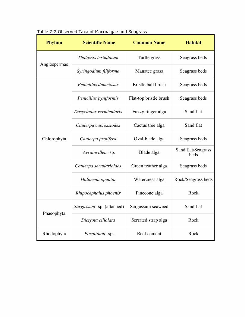
Table 7-2 Observed Taxa of Macroalgae and Seagrass
Phylum Scientific Name Common Name Habitat
Thalassis testudinum Turtle grass Seagrass beds
Syringodium filiforme Manatee grass Seagrass beds
Penicillus dumetosus Bristle ball brush Seagrass beds
Penicillus pyniformis Flat-top bristle brush Seagrass beds
Dasycladus vermicularis Fuzzy finger alga Sand flat
Caulerpa cupressiodes Cactus tree alga Sand flat
Caulerpa prolifera Oval-blade alga Seagrass beds
Avrainvillea sp. Blade alga Sand flat/Seagrass beds
Caulerpa sertularioides Green feather alga Seagrass beds
Halimeda opuntia Watercress alga Rock/Seagrass beds
Rhipocephalus phoenix Pinecone alga Rock
Sargassum sp. (attached) Sargassum seaweed Sand flat
Dictyota ciliolata Serrated strap alga Rock
Rhodophyta Porolithon sp. Reef cement Rock
Angiospermae
Chlorophyta
Phaeophyta
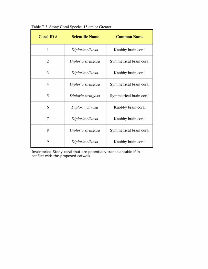
Table 7-3. Stony Coral Species 15 cm or Greater
Coral ID # Scientific Name Common Name
1 Diploria clivosa Knobby brain coral
2 Diploria stringosa Symmetrical brain coral
3 Diploria clivosa Knobby brain coral
4 Diploria stringosa Symmetrical brain coral
5 Diploria stringosa Symmetrical brain coral
6 Diploria clivosa Knobby brain coral
7 Diploria clivosa Knobby brain coral
8 Diploria stringosa Symmetrical brain coral
9 Diploria clivosa Knobby brain coral
Inventoried Stony coral that are potentially transplantable if in conflict with the proposed catwalk

Table 8-1 Summary of Potential Concerns
Map ID
Ecological Concern
Length of Impact
Estimated area of Impact
Mitigation Measures
1 Pineland 0.92 miles 4.46 Acres Direct impact to Pineland unlikely to adversely effect listed species
2 Mangrove Wetland
0.12 Miles 0.58 Acres
Direct impacts may not jeopardize listed species, Best Management Practices (BMP) should be employed during construction e.g. the use of dewatering settling ponds, silt fences and turbidity booms. Also there may be some opportunity to directly re-connect some degree of tidal flow under the historic Wilson City Road as a partial mitigation measure
3 Coppice 0.06 miles 0.29 acres Direct impact to Coppice unlikely to adversely effect listed species. Additional approvals may be required if old growth mahogany in conflict
4 Mangrove Wetland
0.06 miles 0.29 acresDirect impacts may not jeopardize listed species, BMP should be employed during construction e.g. the use of dewatering settling ponds, silt fences and turbidity booms.
5 Dead Coppice 0.54 miles 2.61 acres Direct impact to Coppice unlikely to adversely effect listed species. Additional approvals may be required if old growth mahogany in conflict
6 Coppice 0.57 miles 2.76 acresDirect impact to Coppice unlikely to adversely effect listed species.Additional approvals may be required if old growth mahogany in conflict
7 Shoreline /bay
700 ft Retaining wall proposed, BMP use during construction, Biologist on-hand if construction proposed during shark mating season
8 Coppice 0.45 miles 2.18 acresDirect impact to Coppice unlikely to adversely effect listed species.Additional approvals may be required if old growth mahaogany in conflict
9 Coppice (Dock)
2 acresDirect impact to Coppice unlikely to adversely effect listed species. Additional approvals may be required if old growth mahogany in conflict. If possible flag and work around.
10 Ironshore (Dock)
unknown Direct impact to Ironshore unlikely to adversely effect listed species.
11 Sand Flats 109 ft dia. of piles Marine BMP, turbidity curtains and relocate Stony coral (as required) if in conflict with construction
12 Patchy Sea Grass
30 ft dia. of piles Marine BMP, turbidity curtains and relocate Stony coral (as required) if in conflict with construction
13 Dense Turtle Grass
11 ft dia. of piles Operational SPCC Plan and marine monitoring. Area is genereally outside of the proposed construction of the 150 ft cat walk
14 Wilson City Artifacts
Unknown Flag and identify any Wilson City artifacts exposed by construction and have preservationists available to make a determination.
Source: kes 2009
Sea of Abaco (Proposed 150 ft Catwalk)
Cultural Impacts
Adjacent Wilson City Road
Spencer's Bight
Dock Road Extension
Proposed Dock

Table 11-1 Impacts Determination Summary
1
The impact of the construction utility easement is generally of limited concern. Thefollowing is a summary of unavoidable negative impacts and project benefits.
I. Land Use Impactdetermination
Description
Be compatible withexisting land use?
PotentialSignificant
Beneficial Impact
The project ROW located in undeveloped CrownLand, consisting of Pine and Coppice Uplands. Thegeneration of reliable power is of benefit to the peopleof Abaco
Be compatible withzoning and other landuse requirements?
PotentiallySignificant
Beneficial Impact
The proposed industrial land use is consistent with thedevelopment of Wilson City during the 1906-1916lumber era and the subsequent sugar use between1950 and 1970 in the site vicinity
Be compatible withenvironmental laws,regulations applicable tothe project or required ofthe proponent?
PotentiallyAdverse Impact
It is BEC’s policy and position to operate the facilityin accordance with Bahamas environmental rules andregulations, with the goal of promoting and ensuringgood environmental and ecological stewardship.
Include unique orunusual landforms in theimmediate project area(project foot print)?
No Impact No unique or unusual landforms are located within theproject footprint. Not applicable to project
Include unique orunusual landforms in theimmediate project area(surrounding area)?
No Impact No unique or unusual landforms are located in projectvicinity. Not applicable to project
II. Geology Impactdetermination
Description
Include activities such asconstruction that willdisturb the soil.eg.(excavation) ?
PotentiallyAdverse impact
Site clearing of trees in conflict with the project andtrenching required is required. At the completion ofimprovements, the corridor will be graded.
Result in subsidence ofthe land
No Impact Not anticipated.
Influence land slides ormud flows
No Impact Site consists of Lucayan Limestone, generallyconsidered to be hard and stable. Not applicable toproject
Be located in aseismically active area
No Impact No record of seismic activity in the area. Notapplicable to project

Table 11-1 Impacts Determination Summary
2
III. Water Quality Impactdetermination
Description
Alter the quality,amount, direction, or rateof flow of groundwater?
No Impact No alteration to groundwater flow is anticipated byROW project
Affect any municipal orprivate drinking watersupplies?
No Impact ROW project is located outside of the e Lake City-Marsh Harbour aquifer No impacts anticipated fromROW project
Alter the exposure ofcertain sensitivereceptors to waterpollutants?
PotentiallyAdverse Impact
Mangroves will be impacted during construction, butanticipated to recover following completion of ROW
Alter the drainageflow/patterns orabsorption rates ofsurface water ?
PotentiallyAdverse Impact
The dock site will be graded, asphalted andlandscaped. Surface flow regimes across the site willbe altered. Storm water flow will be directed to onsiteappurtenance via oil/water separators prior todischarge. The loss of drainage via infiltration willnot impact areas or ecology adjacent to the site andsite water management is beneficial to the project.
Occur within afloodplain?
No Impact Not located in a flood plain, but as with all of theisland, is susceptible to tropical storms
Result in discharge tosurface water (both freshand saltwater) and altersurface water quality
No Impact No surface water discharges are proposed for theproject.
Result in siltation tosurface water (bothfreshwater and marinewater areas)?
PotentiallyAdverse Impact
A potential for increase sedimentation is anticipatedduring the construction phase of the dock andpipeline. Both are anticipated to be of localsignificance and short duration. The impacts will beminimized by use of BMPs, during construction,incorporating the use of silt curtains, buoys, andsedimentation barriers.

Table 11-1 Impacts Determination Summary
3
IV. Biological Resources Impactdetermination
Description
Affect globally, regionally,or locally rare plant oranimal species of theirhabitats?
PotentiallyAdverse Impact
14-acres of upland habitat will be lost to theproject. Tree removal as required by the projectwill be conducted with permit approval. Potentialfor Mahogany trees to be present and in conflict.Exotic and opportunistic flora along the pipelineROW route and dock site will be removed.
Affect the overallbiodiversity of the affectedecosystem(s)?
PotentiallyAdverse Impact
Little or no impact are anticipated to fauna e.g.birds, which are mobile and will relocate. Otheranimals (if any) will also relocate into the adjacentareas of undisturbed Crown Land and further southto the Abaco National Park
Affect coral reefcommunities?
PotentiallyAdverse Impact
Stony Corals were identified potentially in conflictwith project and will require relocation. Inaddition, dock construction will result in impactsthat are local and of short duration (if any).
Affect Mangroves? PotentiallyAdverse Impact
During pipeline trenching and installation the useof silt curtains and sedimentation barriers isrequired of the BMP to reduce and/or eliminatespotential impacts to the mangrove area thatintercepts the pipeline route. One acre ofmangroves directly impacted. Mangroves atSpencer’s Bight to be protected by silt curtains
Affect sea grass beds ? PotentiallyAdverse Impact
Sea grass was observed proximal to Wilson Citydock. Use of BMP applicable. Impacts should belocal and short duration (if any)
Affect dunes? No Impact Not applicable to projectAffect other sensitive coastalenvironments (e.g. parks,wildlife refuge, and marinesanctuaries)?
PotentiallyAdverse Impact
The proposed industrial use of the dock has raisedconcerns of impacts to the sensitive environmentsin the Sea of Abaco. These concerns are mitigatedby implementation of EMPs and BMPs, for thepower plant and the operation of commerce inaccordance with Bahamas Maritime Authoritymandates. The power needs of Abaco outweighany potential local adverse impacts (if any).However, Significant Adverse Impact is a concernshould a discharge occur adjacent to Pelican CayNational Park.
Affect freshwater, riparian,or other coastal wetlands (i.e.Non-mangrove areas, such assalt marshes)?
No Impact No salt marshes present. Not applicable to project
Affect Upland habitats? PotentiallyAdverse Impact
14-acres of pine and coppice habitat will be lost tothe project. Caribbean Pine and Mahogany (if any)removal as required by the project will beconducted with permit approval.

Table 11-1 Impacts Determination Summary
4
Affect protected areas (e.g.Parks, wildlife refuges,marine sanctuaries)?
PotentiallyAdverse Impact
No impacts are anticipated to Abaco National Parklocated 23-miles to the south. No direct impact toPelican Cays Land and Sea Park. However, it isacknowledged that commercial ships using NorthBar Channel to enter the Sea of Abaco will traversePSLSP
Affect fish, shellfish or othercommercially importantmarine species?
PotentiallyAdverse Impact
It has been suggested that the industrial use of thedock to service the power plant, has the potential toimpact the ecosystem in the Sea of Abaco.However, the offshore concerns are mitigatedthrough the mandates of the Bahamas MaritimeAuthority.
V. Air Quality Impactdetermination
Description
Alter the local air qualitydirectly (e.g. fromconstruction activities, or thenature of the project)?
PotentiallyAdverse Impact
Any potential impacts during construction oroperation are mitigated by the remote location ofthe site and the distance from the closestpotentially sensitive receptor.
Alter the local air qualityindirectly (e.g. from anincrease in cars, boats,parking lots)?
PotentiallyAdverse Impact
Fugitive emissions are anticipated duringconstruction. These are anticipated to be localizedand of short duration.
Alter the exposure level ofcertain sensitive receptors toair pollutants?
No Impact No combustion associated with ROW. Notapplicable to project
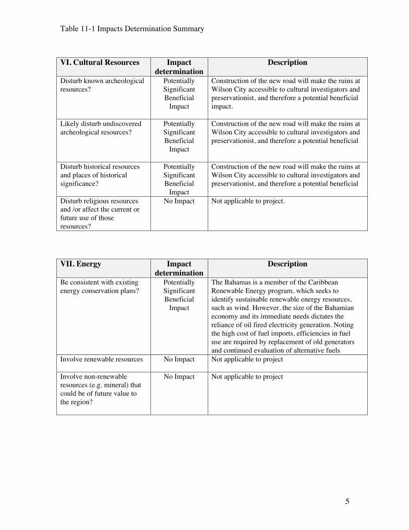
Table 11-1 Impacts Determination Summary
5
VI. Cultural Resources Impactdetermination
Description
Disturb known archeologicalresources?
PotentiallySignificantBeneficial
Impact
Construction of the new road will make the ruins atWilson City accessible to cultural investigators andpreservationist, and therefore a potential beneficialimpact.
Likely disturb undiscoveredarcheological resources?
PotentiallySignificantBeneficial
Impact
Construction of the new road will make the ruins atWilson City accessible to cultural investigators andpreservationist, and therefore a potential beneficial
Disturb historical resourcesand places of historicalsignificance?
PotentiallySignificantBeneficial
Impact
Construction of the new road will make the ruins atWilson City accessible to cultural investigators andpreservationist, and therefore a potential beneficial
Disturb religious resourcesand /or affect the current orfuture use of thoseresources?
No Impact Not applicable to project.
VII. Energy Impactdetermination
Description
Be consistent with existingenergy conservation plans?
PotentiallySignificantBeneficial
Impact
The Bahamas is a member of the CaribbeanRenewable Energy program, which seeks toidentify sustainable renewable energy resources,such as wind. However, the size of the Bahamianeconomy and its immediate needs dictates thereliance of oil fired electricity generation. Notingthe high cost of fuel imports, efficiencies in fueluse are required by replacement of old generatorsand continued evaluation of alternative fuels
Involve renewable resources No Impact Not applicable to project
Involve non-renewableresources (e.g. mineral) thatcould be of future value tothe region?
No Impact Not applicable to project

Table 11-1 Impacts Determination Summary
6
VII. Socioeconomics Impactdetermination
Description
Directly or indirectly resultin increased populationgrowth in the projectvicinity?
PotentiallySignificantBeneficial
Impact
New Road may promote additional recreationalopportunities. Abutting and adjacent lands arecrown lands and are undeveloped.
Affect unemployment/jobavailability?
PotentiallySignificantBeneficial
Impact
Some short tem opportunities associated withconstruction of ROW and road improvements.
Directly or indirectly resultin additional (i.e., non-project related) economicgrowth in the projectvicinity)?
PotentiallySignificantBeneficial
Impact
Potential indirect impact as an economic centermight occur as local venders seek to service thepower plant, based in part on its remote location,and the distance of Spring City and Marsh Harbour
Affect local housingavailability?
No Impact No housing developments are adjacent to theproperty. Not applicable to project
Displace or otherwise affectexisting housingdevelopments, especiallyinvolving minority and low-income communities?
No Impact No housing developments are adjacent to theproperty. Not applicable to project
Impact public health andsafety due to the intentional;or unintentional release ofhazardous substances,flammable liquids, toxicpollutants, etc?
PotentiallyAdverse Impact
No impacts to public safety are anticipated. In theevent of an unintentional release at the dock, spillcontainment protocols well be used and,emergency response contractors mobilized in theevent of a catastrophic event.
Impact worker health andsafety due to the intentional;or unintentional release ofhazardous substances,flammable liquids, toxicpollutants, etc?
PotentiallyAdverse Impact
Worker occupational health & safety was notspecifically addressed in this EIA. However, theconstruction vender will be required to haveavailable and implement a Health & Safety Planfor construction.

Table 11-1 Impacts Determination Summary
7
IX. Community Service Impactdetermination
Description
Affect availability of, ordemand for, fire protectionservices?
PotentiallyAdverse Impact
In the case of a small fire, fire containment will beperformed by onsite personnel, with the use ofavailable extinguisher providing there is no risk ofinjury. In the event of an uncontrollable forest fire,the Marsh Harbour fire department is a volunteerforce that would be severely stressed to manage afuel-based fire.
Affect availability of, ordemand for, policeprotection services?
No Impact No demand for police protection services isanticipated. Not applicable to project
Affect availability of, ordemand for, medical andhealth care services?
No Impact The demand for medical services will be no greaterthat that currently required for Marsh Harbourpower station. Not applicable to project
Affect availability of, ordemand for, public waterservices, including municipalwastewater supplies andstorm water drainage
No Impact All water use and disposal systems will be locatedonsite and are purpose built to satisfy the needs ofthe project. No demands or access to publicsystems is required or anticipated. Not applicableto project
Affect availability of, ordemand for, public wastewater services
No Impact All water use and disposal systems will be locatedonsite and are purpose built to satisfy the needs ofthe project. No demands or access to publicsystems is required or anticipated. Not applicableto project
Affect availability of, ordemand for, schools andrelated educational supportservices?
No Impact Not applicable to project
Affect availability of, ordemand for, communicationsystems?
No Impact Not applicable to project
Affect availability of, ordemand for, power
PotentialSignificantBeneficial
Impact
The objective of the ROW project is to provide fuelto the plant which will generated reliable andaffordable electricity to support the needs andeconomy of the Abacos
Affect availability of, ordemand for, solid wastedisposal services
No Impact GC will be responsible for properly managing allwaste streams during construction

Table 11-1 Impacts Determination Summary
8
X. Aesthetics Impactdetermination
Description
Result in objectionable odorsto surrounding areas?
PotentiallyAdverse Impact
The transmission of heavy fuel oil will result in apotentially objectionable odor at the dockHowever, the closest sensitive receptor is more thateight miles from the site, and no impacts areanticipated at Spring City
Affect local noise standards(or existing conditions)?
PotentiallyAdverse Impact
Based upon the remoteness of the site, anypotential noise exceedance beyond the sitesproperty line is mitigated by the distance of theclosest sensitive receptor
Affect scenic views? No Impact The ROW at completion will be grade andcamouflaged by vegetation. At completion thedock will be observable from the Sea of Abaco
Create light or glare? No Impact Low-level security lighting at night anticipated.
XI. Recreation Impactdetermination
Description
Affect the quality of land–based recreationalopportunities?
PotentiallySignificantBeneficial
Impact
Proposed improvements to Wilson City Road, andconstruction of the dock, will increase the potentialfor land based recreational opportunities, providesaccess to the Wilson City cultural resource andbeaches
Affect the quality ofwater–based recreationalopportunities?
PotentiallySignificantBeneficial
Impact
Proposed improvements to Wilson City Road, andconstruction of the dock, will increase the potentialfor water based recreational opportunities, whoaccess the water from the bays proximal to thedock
Increase the demand forrecreational facilities oropportunities?
No Impact Not applicable to project
Affect the quantity or qualityof open space?
PotentiallyAdverse Impact
Loss of 14 acres of upland is an unavoidableconsequence of the project. However, the removalof this land, will not impact the quality of theremaining crown lands or the land protected byAbaco National Park
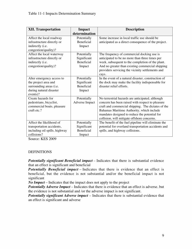
Table 11-1 Impacts Determination Summary
9
XII. Transportation Impactdetermination
Description
Affect the local roadwayinfrastructure directly orindirectly (i.e.congestion/quality)?
PotentiallyBeneficial
Impact
Some increase in local traffic use should beanticipated as a direct consequence of the project.
Affect the local waterwayinfrastructure directly orindirectly (i.e.congestion/quality)?
PotentiallySignificantBeneficial
Impact
The frequency of commercial docking use isanticipated to be no more than three times perweek, subsequent to the completion of the plant.And no greater than existing commercial shippingproviders servicing the vicinity settlements andcays.
Alter emergency access tothe project area andsurrounding areas (i.e.during natural disasterevents)?
PotentiallySignificantBeneficial
Impact
In the event of a natural disaster, construction ofthe dock may make the facility indispensable fordisaster relief efforts.
Create hazards forpedestrians, bicyclist,commercial boats, pleasurecraft etc.?
PotentiallyAdverse Impact
No terrestrial hazards are anticipated, althoughconcern has been raised with respect to pleasurecraft and commercial shipping. The dictates of theBahamas Maritime Authority, which includemandates designed to reduce the potential forcollision, will mitigate offshore concerns.
Affect the likelihood oftransportation accidents,including oil spills, highwaycollisions?
PotentiallySignificantBeneficial
Impact
The benefit of the fuel pipeline will eliminate thepotential for overland transportation accidents andspills, and highway collisions.
Source: KES 2009
DEFINITIONS
Potentially significant Beneficial impact – Indicates that there is substantial evidencethat an effect is significant and beneficialPotentially Beneficial impact – Indicates that there is evidence that an effect isbeneficial, but the evidence is not substantial and/or the beneficial impact is notsignificantNo Impact – Indicates that the impact does not apply to the projectPotentially Adverse Impact – Indicates that there is evidence that an effect is adverse, butthe evidence is not substantial and /or the adverse impact is not significant.Potentially significant Adverse impact – Indicates that there is substantial evidence thatan effect is significant and adverse