Embed Size (px)
Citation preview
Section 5
GeologyHydrology
Glenurquhart & Strathglass Wind Energy Project

Orkney Sustainable Energy Report OSE/2883 Geology
Glenurquhart & Strathglass Wind Energy Project
Geology, Superficial Deposits and Hydrology
Report OSE/2883: Section 5
March 2010
Client:
Mike Girvan
Corrimony Energy Ltd
Assessment:
Richard Gauld
BSc(Hons) IEng MInstMC Dip.GeoSci
Orkney Sustainable Energy Ltd
6 North End Road
Stromness
Orkney KW16 3AG

Orkney Sustainable Energy Document OSE/2883 Geology March 2010
2
1 Summary
1.1 A wind energy project is proposed for a moorland plateau between Cannich and
Drumnadrochit near Inverness. The project consists of five wind turbines, an upgraded
access track and a switchgear building, all to be owned by local companies.
1.2 As part of the planning process, studies relating to the possible effects of the wind
turbine development on the geology, superficial deposits, hydrogeology and hydrology
beneath and across the site have been undertaken.
1.3 The site and route of the access track have been surveyed over two years as part of the
project ecological assessment, with any hydrological features noted and mapped. The
project layout has evolved over the assessment period, and as the project has been
designed to have minimum ecological impact, care has been taken to avoid areas of
sensitive habitats. In addition, a walkover survey was completed, identifying any
surface water features, including sources, drains and burns.
1.4 The bedrock in the area is uniform metamorphic quartz-feldspar granulites of
Precambrian age. Folding of the rock is not significant, and rocky outcrops are present
throughout the site, particularly along the western slope of the hill.
1.5 The project has evolved to take into account ground conditions. In particular care has
been taken to avoid areas of peat or blanket bog, with the project infrastructure
positioned in area away from deep peat or bog. Water crossings have also been avoided,
with one new bridge required to cross the upper reaches of the River Enrick. The main
superficial deposit on the site is a thin draping of peat over part of the hill proposed for
the development. The deepest peat has been avoided by ensuring the access track
travels between all five turbines in a circuit; maximum recorded peat depth on the
turbine sites and along the route of the access track was around 0.5m
1.6 Assessment of the risk of possible ice and snow effects has been completed, with a low
probability of icing, and in any event the turbine site is well away from housing, public
roads and powerlines; the turbines are a minimum of 300m away from the track to east
of the site. Consequently ice throw is not predicted to be a significant issue for the
Glenurquhart & Strathglass Wind Energy Project
1.7 Hydrological management and pollution prevention measures are discussed, with a
series of recommendations presented.

Orkney Sustainable Energy Document OSE/2883 Geology March 2010
3
2 Landscape and Geomorphology
2.1 The project is located on Sliabh an Ruighe Dhuibh, a minor hill at the head of River
Enrick, in a remote and isolated moorland area between Glen Affric, Glen Moriston and
Loch Ness. Access to the site follows an existing track through Corrimony farm, and an
underground cable will be routed over to the Fasnakyle Power Station at Cannich, with a
switchgear house located near the power station, Figure 1.
2.2 The general area is defined as Rocky Moorland Plateau in the South Inverness
Landscape Character Assessment, and consists of a high rocky plateau, rising to the
more mountainous areas in the west, and bordering the Great Glen to the east. This
landscape type is characterised by small rocky hills which rise out of open, gently
rolling moorland plateaux. These plateaux possess distinct edges which isolate them
from adjacent areas which are generally not visible from their interior, creating an
impression of being within a remote upland moor. Rocky heather moorland dominates
the hilltops and upper slopes, and numerous small lochans and areas of bog occupy
depressions. Regenerating woodland concentrates along river valleys and form sporadic
patches on hillsides.
2.3 The geomorphology of the site is to a large degree controlled by the underlying geology.
The underlying rocks are made up of hard, metamorphosed sediments, which have been
cut by glaciers to create ranges of rugged, irregular mountains, covered in numerous
rocky outcrops, lochans and scattered glacial debris. Throughout these uplands, the
routes of glaciers have also emphasised fault weaknesses to create long, steep-sided
glens which sub-divide the mountains into a series of distinct ranges. Peat covers much
of the area, draping the bedrock with varying depths of superficial deposits.
2.4 Anthropological influences in recent years have altered the landscape. The boggy floors
of the straths were drained in the 18th century, converted into rich meadows and
eliminating the need to move cattle to high ground during the summer months. As a
result the character of many of the straths and glens changed radically; older traditional
landuse has disappeared, replaced by a more regular pattern of pastoral and arable fields
along the lower slopes, and large farmhouses surrounded by pastoral meadows along the
drained strath floors. Although the straths and glens have changed, the upper hills and
more remote moorland areas have not seen the effects of agricultural improvement, and
animal stock levels are low, with only limited anthropological impact.
Orkney Sustainable Energy Document OSE/2883 Geology March 2010
4
3 General Geology
3.1 This is a relatively homogenous area from a geological perspective, dominated by
metamorphic bedrock that was originally an area of sand and mud deposited 1000M
years ago. The establishment of the Moine thrust zone and the subsequent creation of
the Caledonian mountain range around 400M years ago resulted in deformation and
metamorphosis over a wide area. The Great Glen fault to the east of Corrimony is a
significant boundary, and is a major strike/slip fault that defines the boundary between
the older Northern Highlands to the west, and the Grampian Highlands to the east.
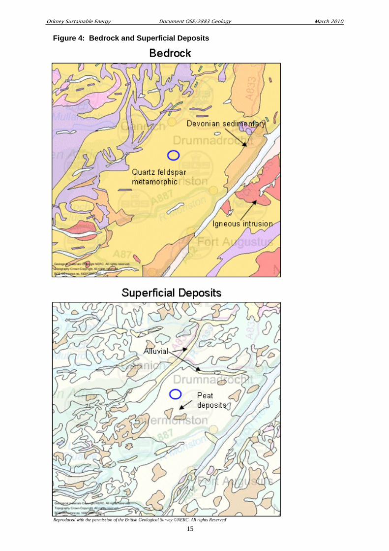
3.2 An assessment of the geology and the hydrogeological features of the area was
conducted with reference to maps produced by the British Geological Survey [2,3,4]..
These maps identified the extent of superficial deposits in the area, mainly peat and
glacial till soils, along with alluvial silt along the glens and straths to the north and west
of the site. The bedrock geology in this part of the Highlands is mainly quartz-feldspar
granulites of Moine age (1000– 873 Ma), Figure 4. Around 10km to the north east, the
Glen Urquhart Complex is a small intrusion of serpentinite that includes schist, gneiss
and bands of limestone.
3.3 The elevated plateau landforms present throughout this part of the Highlands are a
consequence of the extensive glaciation that has occurred, with major ice sheets
developing around 850,000 years ago. The last ice sheet disappeared around 15,000
years ago, and the passage of these ice sheets resulted in heavily glaciated valleys cut
into the gneiss and Moine rocks, giving a landscape which is rugged and boggy with
steep wooded valley sides and bare rocky hills.
3.4 The turbines are to be positioned on an area of hard bedrock on Sliabh an Ruighe
Dhuibh, with glacial till deposits giving rise to hummocky terrain. The topsoil varies
across the site with topography and aspect, with the upper River Enrick valley floor
dominated by brown earth soil, along with deep peat where drainage is poor. There is a
thin draping of peat on the upper slopes of the hill, with peaty podzols, peaty soils and
peaty gleys.
Orkney Sustainable Energy Document OSE/2883 Geology March 2010
5
4 Hydrology and Hydrogeological Features
4.1 A soil and hydrological investigation of the access route and the turbine site has been
completed, with reference to the following resources:
• Soil Survey of Scotland, 1: 50000 Scale Map number 73
• Land Use Capability, 1:50000 Scale Map number 73.
• OS 1:25000 Explorer Map number 415
• River Enrick Flood Risk Assessment; Glen Urquhart Land Use Partnership.
• The Design of Field Drainage Pipe Systems; MAFF Ref. 345.
• The Climate of the Agricultural Areas of Scotland; Met. Office.
• FEH CD-ROM 1999; CEH Institute of Hydrology, Wallingford.
• CIRIA C521; Sustainable urban drainage – design manual for Scotland and Northern Ireland
• CIRIA C697; The SUDS Manual
4.2 The River Enrick is approximately 26km long, and runs from the elevated landscape
around Sliabh an Ruighe Dhuibh, to join Loch Ness at Drumnadrochit. There have been
six major flooding events in recent years over the last two decades, resulting in a
detailed assessment of flood risks along Glen Urquhart.
4.3 Annual rainfall has been measured at the Mill of Tore Gauging Station, on the River
Enrick downstream of Corrimony; average annual rainfall for the last decade has been
1378mm. Rainfall levels in the area are moderate for the Highlands, largely due to the
rainshadow effect of the mountains to the south and west.
4.4 At Corrimony the river has a raised bed, with an extensive flood plain. River flows
have been managed to a certain extent, with embankments and barriers controlling local
floods. The source of the Erick is upstream of Corrimony, with two branches of the
river either side of the elevated turbine site, Figure 2. To the east of Sliabh an Ruighe
Dhuibh the river follows a steep and narrow route, with a series of small waterfalls. To
the west, the river flows more slowly along the valley floor; the source of the river is a
series of small lochans, the main one being Loch nan Eun. It should be noted that one
of the sources of the Enrick River is Loch a’Mhuilinn, one of two mill lochs in the area,
indicating that these hills have been used for renewable energy production in the past.
4.5 There are no other significant hydrological features to consider; the site access tracks
have avoided water crossings. There will be the need to cross the western tributary of
the river, and although there is a bridge in place at present, this will require replacement
Orkney Sustainable Energy Document OSE/2883 Geology March 2010
6
before any work can commence on the site; a simple slab and pier structure will be put
in place. The cable to Fasnakyle goes underneath two water courses; this should be
done using either directional drilling or by installing ducting in the river beds.
4.6 It is recommended that care should be taken to avoid pollution on the upper reaches of
the Enrick, and it is suggested that SEPA’s Pollution Prevention Guidelines PPG1,
PPG5, PPG6, PPG8 and PPG21 [5] should be adopted by the project. To combat the
potential risk of run-off from the track, it is recommended that mechanisms used to
construct Sustainable Urban Drainage systems be adopted, using a permeable surface on
the access track to allow water to pass through the upper layer, along with filter strips
and bunds of vegetated land to provide filtering and flow attenuation of water run-off.
5 Superficial deposits and topsoil stability; Peat Slide
5.1 Peat is a biogenic superficial deposit which when saturated consists of about 90-95%
water. The organic content of the solid part of peat is very high, and is made up of the
decayed remains of vegetation which has accumulated over a timescale of 100s of years.
5.2 Site assessment confirmed that there are very few major peat deposits in the area,
mainly around Loch ma Stac, 4km to the south of the turbines. These peat deposits
follow the shape of the bedrock, draping over the land in a blanket covering. The slope
of the hill is around 5° at the steepest, flattening out at the upper parts of the site.
5.3 Peat of varying depth and wetness underlies all of the moorland and the drained and
planted areas, with the most extensive deeper peat lying at the centre of the part of
Sliabh an Ruighe Dhuibh proposed for the development, Figure 3. The hill slopes
around the site have not been subject to peat cutting and there is only very limited
artificial drainage, close to the existing track in places.
5.4 Deep peat is not present at the locations chosen for the turbines, with only a thin layer of
around 0.5m present at the turbine positions and along the route of the access track. The
top of the hill is fairly level and mostly clothed in deep peat of a depth of around 1m,
with clusters of bog pools, particularly in the wetter central section. The steep slope to
the west has a thinner covering of peat with occasional outcrops of rock, and the route of
the access track has been designed to avoid areas of deep peat.
5.5 Despite avoiding areas of deep peat, around 5000m3 will be removed, based on the peat
depth measurements made along the track and on the spur, and the dimensions of the
Orkney Sustainable Energy Document OSE/2883 Geology March 2010
7
infrastructure elements. Where required some of this would be used at the point of
removal to form sloping verges around the turbine hardstandings and along the sides of
the uppermost access route. The remainder of the peat would be partly or wholly used
in reinstatement of the turbine hardstandings, and to infill the borrow pits plus an
existing pit further up along the track. The borrow pits would be filled to a depth of 1 to
1.5m, allowing for reinstatement of the vegetation as blanket bog.
5.6 Landslides, bog flows and bog bursts are widespread in the uplands of the British
Isles[6], and these movements are usually triggered by heavy or prolonged rainfall. Peat
slide involves instability of peat deposits over a rock or mineral subsurface, resulting in
slab-like failure.[7]. Bog burst involve the rupture of peat surfaces due to internal
swelling, resulting in disruption of the surface[8].
5.7 Landslide and peat movement share several common characteristics, all relating to hill
slope hydrological processes:
a. . A superficial layer overlying an impervious rock, clay or mineral base;
b. A convex slope or a slope with a break of slope at the head;
c. Proximity to local drainage either from seepage or groundwater flow;
d. A connection between surface drainage and the soil/rock interface.
5.8 Although peatslide is not fully understood, the hydrological process which triggers the
event is likely to be an increase in water flow at the interface between the peat layer and
the underlying impermeable base. Analysis of recorded peat movements in the British
Isles indicated that more than half occurred in the late summer months of October and
August [7]. suggesting that summer storms and periods of above average rainfall can
trigger slides. Slope form is also likely to influence hillside hydrology and stability.
Peat slides often occur on convex slopes, however slope angle can vary considerably; a
study of 18 occurrences of peat instability in the Pennines recorded slope angles of 4° to
24°[7].
5.9 There is little risk of peat slide at Corrimony. Drainage conditions and topography have
been considered and neither the access track nor the hardstanding areas have the
characteristics of an area at risk of landslide. The access track will be constructed to
ensure that water cannot drain into the interface between superficial layers and the
bedrock. The access track to the site will be aligned to ensure the track does not cut
across the slope, and the construction process will ensure that water does not drain into
the peat/rock interface, again to minimise the potential risk of peat slide.

Orkney Sustainable Energy Document OSE/2883 Geology March 2010
8
6 Ice and Snow Effects
6.1 The Corrimony area has a moderate average rainfall of around 1400mm per annum, and
consequently snow volumes are low due to rainshadow effects [9] .
6.2 The climate around this part of the Highlands is essentially mild in the summer and
typically cold in winter. Heavy snow fall is rare, and on average, the number of days
with snow falling is typically around 30 per winter; the winter of 2009/2010 was an
exceptionally unusual.
6.3 A European study has been completed into the likelihood of icing conditions occurring,
and the areas most likely to have blade icing include Germany, Austria, Switzerland,
France and the Spanish border region[10]. The Wind Energy Production in Cold
Climates Study (WECO) describes Scotland as a whole as having occasional to light
icing conditions, and it is predicted that the Glenurquhart & Strathglass turbines will be
subject to icing effects due to the relevant ice and snow conditions on perhaps three days
in the year.
6.4 When considering the possibility of ice throw from a turbine, the same WECO project
has the following statement:
“Ice throw is an essential problem when the site of the wind energy power plant is
planned to be close to public roads, housing, power lines etc. According to the data and
models developed and verified within the project it can be recommended for sites with
high probability of icing to keep a distance between the turbines and nearest objects of
about (hub height + diameter), or it can be recommended to stop the turbine
automatically during the icing period and wind coming from unfavourable directions, if
the public safety might be affected by ice throw.”
The Glenurquhart & Strathglass turbines have a low probability of icing, and in any
event the turbine site is well away from housing, public roads and powerlines; the
turbines are a minimum of 300m away from the track to east of the site. Consequently
ice throw is not predicted to be a significant issue for the Glenurquhart & Strathglass
Wind Energy Project.

Orkney Sustainable Energy Document OSE/2883 Geology March 2010
9
7 Hydrological management and pollution prevention
7.1 The construction of wind turbine foundations involves pouring fresh concrete. The
nearest watercourses are the burns feeding into River Enrick, approximately 800m from
the turbine site, and to reduce the risk of pollution run-off it is recommended that all
concrete will be brought onto site as a dry mix to minimise the risk of spills. Cleaning
of shutters and the washing of equipment should only be done away from the site
7.2 Track construction will be achieved by excavating down to bedrock, then to mitigate
any surface run-off problems the track will only be constructed in dry conditions, with a
layer of stone immediately placed on the exposed bedrock as the construction
progresses, with crushed rock aggregate sub-bottoming placed on top of the as-dug rock.
All displaced soil will be relocated into depressions and other areas in the turbine field.
7.3 Track construction will follow the general SUDS guidelines published by SEPA, with a
porous construction and a free-draining sub layer[11]. The access track will have a filter
strip adjoining the peaty soils to ensure that any water is routed to the upper layers of the
adjacent soil.
7.4 To minimise risk of pollution from oils and fuels during project construction, all work
should be to COSHH regulations and any machinery, equipment or construction
material should be located on areas of hardstanding away from water courses. Any
waste should be transported away from the work area and disposed of using standard
waste handling procedures.
7.5 Fuel or oil pollution would have a drastic affect on water quality should it enter any
water courses, and accordingly refuelling activities for construction vehicles and
equipment should be restricted to bunded and contained areas of hard standing at fuel
storage areas. Good site management should be established:
• Fuel storage should be in double-skinned tanks
• No-refuelling should take place within 100m of a watercourse
• Equipment should be regularly inspected for leaks and spillages
• The site compound should have a full set of absorbent pad spill kits
• Any static plant at the substation compound should be bunded
• Self-contained portaloos and washing facilities should only be located at hardstanding areas.

Orkney Sustainable Energy Document OSE/2883 Geology March 2010
10
References and bibliography
1 SNH Publications, Scottish Natural Heritage: South Inverness Landscape Character
Assessment.
2 British Geological Survey. Geological Survey One-Inch Survey Map
3 British Geological Survey. Soil Survey of Scotland, 1: 50000 Map No. 73
4 British Geological Survey. Land Capability for Agriculture, Map No. 73
5 SEPA pollution prevention guidelines: http://www.sepa.org.uk/guidance/ppg/
6 Tomlinson, R.W, Gardiner T, (1982). Seven bog slides in the Slieve-an-Orra Hills,
County Antrim. Journal of Earth Science, Royal Dublin Society 5.
7 Warburton J., Holden J., Mills A.J. (2004). Hydrological controls of surficial mass
movements in peat. Earth Science Review 67 139-156.
8 Bowes, D.R. (1960). A bog-burst in the Isle of Lewis. Scottish Geographical Journal 76,
21-23.
9 SEPA: Rainfall levels and Hydrological Summary for Mill of Tore, River Enrick
10 Finnish Metrological Institute. Wind Energy Production in Cold Climates.
http://www.fmi.fi/research_meteorology/meteorology_9.html#5
11 Jefferies C. (2004) SUDS in Scotland – The Monitoring Programme, Urban Water
Technology Centre, University of Abertay:
http://sudsnet.abertay.ac.uk/SNIFFERReport0251.htm

Orkney Sustainable Energy Document OSE/2883 Geology March 2010
11
Appendix:
Figures

Orkney Sustainable Energy Document OSE/2883 Geology March 2010
12
Switchgear building
Switchgear building
Substation
Cable Route
Access
Access
Access
Reproduced from Ordnance Survey Data, Crown Copyright Reserved. License No. 0100031673
Figure 1: Site Overview

Orkney Sustainable Energy Document OSE/2883 Geology March 2010
13
Switchgear building
Access
New Bridge
Access
Cable ducting under stream
Burns
New Access
Figure 2: Main Hydrological Features
Reproduced from Ordnance Survey Data, Crown Copyright Reserved. License No. 0100031673

Orkney Sustainable Energy Document OSE/2883 Geology March 2010
14
Figure 3: Peat Depths
Orkney Sustainable Energy Document OSE/2883 Geology March 2010
15
Figure 4: Bedrock and Superficial Deposits
Reproduced with the permission of the British Geological Survey ©NERC. All rights Reserved'