Embed Size (px)
Citation preview
t
t
tt
tt
t
t
t
tt
tt
tt
sg/s
tt
sg
sg
a/f
sw
tt
tt
tt
w
tt w
w
tt
sw
tt
sg
tt sg/s
tt
tt
w
sg
tt
sg/s/f
sg
sg/s/f
w
w
sg/s
t
w
w
a/sg
sg
sg
a/sg
sg
w
sg
tt
sw/f
sg
w
tt
a/sg
sgtt
sg/f
a/sg
sg
sg
a/sg
sg/s
sg/s
a/sg
sg
sg
w
sg/s
w
w
sg
tt
sg
w
sg
sg/s
w
w
s
a/sg
sg
sg
sg
wa/sg
sg
sg/s
sg tt
w
sg/s
a/sg
sw
sg
s
sw
sg
sg
sg/s
sg
sg/s
w
sw
Thompson
CT DEP Quadrangle
Clayv
illeDanie
lson
Oneco
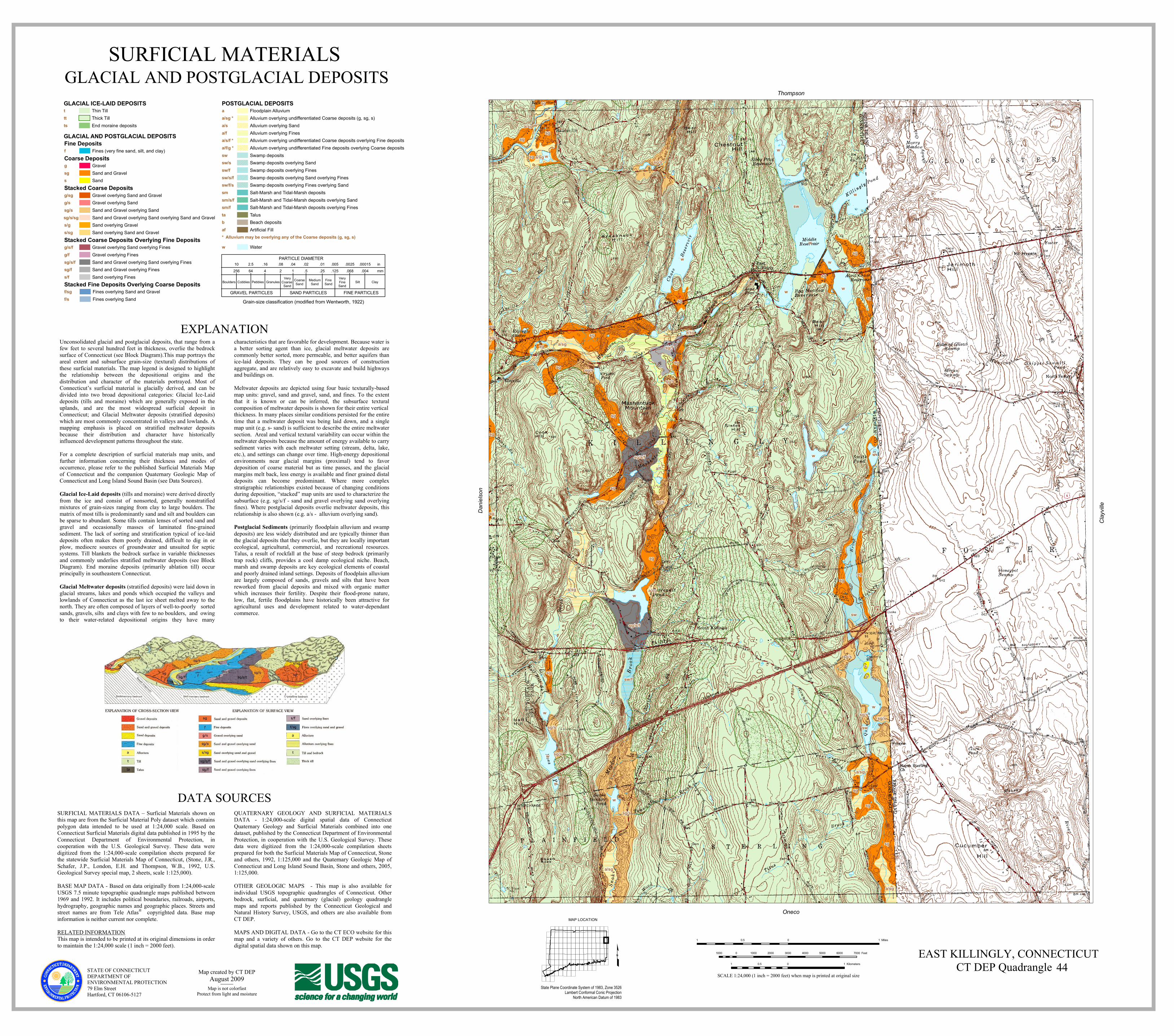
SURFICIAL MATERIALS GLACIAL AND POSTGLACIAL DEPOSITS
£State Plane Coordinate System of 1983, Zone 3526
Lambert Conformal Conic ProjectionNorth American Datum of 1983
MAP LOCATION
STATE OF CONNECTICUTDEPARTMENT OF ENVIRONMENTAL PROTECTION79 Elm StreetHartford, CT 06106-5127
DATA SOURCESSURFICIAL MATERIALS DATA – Surficial Materials shown onthis map are from the Surficial Material Poly dataset which containspolygon data intended to be used at 1:24,000 scale. Based onConnecticut Surficial Materials digital data published in 1995 by theConnecticut Department of Environmental Protection, incooperation with the U.S. Geological Survey. These data weredigitized from the 1:24,000-scale compilation sheets prepared forthe statewide Surficial Materials Map of Connecticut, (Stone, J.R.,Schafer, J.P., London, E.H. and Thompson, W.B., 1992, U.S.Geological Survey special map, 2 sheets, scale 1:125,000).BASE MAP DATA - Based on data originally from 1:24,000-scaleUSGS 7.5 minute topographic quadrangle maps published between1969 and 1992. It includes political boundaries, railroads, airports,hydrography, geographic names and geographic places. Streets andstreet names are from Tele Atlas® copyrighted data. Base mapinformation is neither current nor complete.RELATED INFORMATIONThis map is intended to be printed at its original dimensions in orderto maintain the 1:24,000 scale (1 inch = 2000 feet).
QUATERNARY GEOLOGY AND SURFICIAL MATERIALSDATA - 1:24,000-scale digital spatial data of ConnecticutQuaternary Geology and Surficial Materials combined into onedataset, published by the Connecticut Department of EnvironmentalProtection, in cooperation with the U.S. Geological Survey. Thesedata were digitized from the 1:24,000-scale compilation sheetsprepared for both the Surficial Materials Map of Connecticut, Stoneand others, 1992, 1:125,000 and the Quaternary Geologic Map ofConnecticut and Long Island Sound Basin, Stone and others, 2005,1:125,000.OTHER GEOLOGIC MAPS - This map is also available forindividual USGS topographic quadrangles of Connecticut. Otherbedrock, surficial, and quaternary (glacial) geology quadranglemaps and reports published by the Connecticut Geological andNatural History Survey, USGS, and others are also available fromCT DEP.MAPS AND DIGITAL DATA - Go to the CT ECO website for thismap and a variety of others. Go to the CT DEP website for thedigital spatial data shown on this map.
EXPLANATIONUnconsolidated glacial and postglacial deposits, that range from afew feet to several hundred feet in thickness, overlie the bedrocksurface of Connecticut (see Block Diagram).This map portrays theareal extent and subsurface grain-size (textural) distributions ofthese surficial materials. The map legend is designed to highlightthe relationship between the depositional origins and thedistribution and character of the materials portrayed. Most ofConnecticut’s surficial material is glacially derived, and can bedivided into two broad depositional categories: Glacial Ice-Laiddeposits (tills and moraine) which are generally exposed in theuplands, and are the most widespread surficial deposit inConnecticut; and Glacial Meltwater deposits (stratified deposits)which are most commonly concentrated in valleys and lowlands. Amapping emphasis is placed on stratified meltwater depositsbecause their distribution and character have historicallyinfluenced development patterns throughout the state.For a complete description of surficial materials map units, andfurther information concerning their thickness and modes ofoccurrence, please refer to the published Surficial Materials Mapof Connecticut and the companion Quaternary Geologic Map ofConnecticut and Long Island Sound Basin (see Data Sources).Glacial Ice-Laid deposits (tills and moraine) were derived directlyfrom the ice and consist of nonsorted, generally nonstratifiedmixtures of grain-sizes ranging from clay to large boulders. Thematrix of most tills is predominantly sand and silt and boulders canbe sparse to abundant. Some tills contain lenses of sorted sand andgravel and occasionally masses of laminated fine-grainedsediment. The lack of sorting and stratification typical of ice-laiddeposits often makes them poorly drained, difficult to dig in orplow, mediocre sources of groundwater and unsuited for septicsystems. Till blankets the bedrock surface in variable thicknessesand commonly underlies stratified meltwater deposits (see BlockDiagram). End moraine deposits (primarily ablation till) occurprincipally in southeastern Connecticut.Glacial Meltwater deposits (stratified deposits) were laid down inglacial streams, lakes and ponds which occupied the valleys andlowlands of Connecticut as the last ice sheet melted away to thenorth. They are often composed of layers of well-to-poorly sortedsands, gravels, silts and clays with few to no boulders, and owingto their water-related depositional origins they have many
characteristics that are favorable for development. Because water isa better sorting agent than ice, glacial meltwater deposits arecommonly better sorted, more permeable, and better aquifers thanice-laid deposits. They can be good sources of constructionaggregate, and are relatively easy to excavate and build highwaysand buildings on.Meltwater deposits are depicted using four basic texturally-basedmap units: gravel, sand and gravel, sand, and fines. To the extentthat it is known or can be inferred, the subsurface texturalcomposition of meltwater deposits is shown for their entire verticalthickness. In many places similar conditions persisted for the entiretime that a meltwater deposit was being laid down, and a singlemap unit (e.g. s- sand) is sufficient to describe the entire meltwatersection. Areal and vertical textural variability can occur within themeltwater deposits because the amount of energy available to carrysediment varies with each meltwater setting (stream, delta, lake,etc.), and settings can change over time. High-energy depositionalenvironments near glacial margins (proximal) tend to favordeposition of coarse material but as time passes, and the glacialmargins melt back, less energy is available and finer grained distaldeposits can become predominant. Where more complexstratigraphic relationships existed because of changing conditionsduring deposition, “stacked” map units are used to characterize thesubsurface (e.g. sg/s/f - sand and gravel overlying sand overlyingfines). Where postglacial deposits overlie meltwater deposits, thisrelationship is also shown (e.g. a/s - alluvium overlying sand).Postglacial Sediments (primarily floodplain alluvium and swampdeposits) are less widely distributed and are typically thinner thanthe glacial deposits that they overlie, but they are locally importantecological, agricultural, commercial, and recreational resources.Talus, a result of rockfall at the base of steep bedrock (primarilytrap rock) cliffs, provides a cool damp ecological niche. Beach,marsh and swamp deposits are key ecological elements of coastaland poorly drained inland settings. Deposits of floodplain alluviumare largely composed of sands, gravels and silts that have beenreworked from glacial deposits and mixed with organic matterwhich increases their fertility. Despite their flood-prone nature,low, flat, fertile floodplains have historically been attractive foragricultural uses and development related to water-dependantcommerce.
PARTICLE DIAMETER
VeryCoarse Sand
Boulders Cobbles Pebbles Granules MediumSand ClayFine
SandVeryFineSand
Silt
GRAVEL PARTICLES SAND PARTICLES FINE PARTICLES
CoarseSand
10 2.5 .16 .08 .04 .02 .01 .005 .0025 .00015 inmm256 64 4 2 1 .5 .25 .125 .068 .004
Grain-size classification (modified from Wentworth, 1922)
GLACIAL ICE-LAID DEPOSITSThin TilltThick TillttEnd moraine depositsts
GLACIAL AND POSTGLACIAL DEPOSITSFine Deposits
Coarse Deposits
Stacked Coarse Deposits
Fines (very fine sand, silt, and clay)f
GravelgSand and GravelsgSands
Gravel overlying Sand and Gravelg/sgGravel overlying Sandg/sSand and Gravel overlying Sandsg/sSand and Gravel overlying Sand overlying Sand and GravelSand overlying Gravels/gSand overlying Sand and Gravels/sg
Stacked Fine Deposits Overlying Coarse Depositsf/sgf/s
Stacked Coarse Deposits Overlying Fine DepositsGravel overlying Sand overlying Finesg/s/fGravel overlying Finesg/fSand and Gravel overlying Sand overlying Finessg/s/fSand and Gravel overlying Finessg/fSand overlying Finess/f
Fines overlying Sand and GravelFines overlying Sand
sg/s/sg
POSTGLACIAL DEPOSITS
* Alluvium may be overlying any of the Coarse deposits (g, sg, s)
Floodplain AlluviumaAlluvium overlying undifferentiated Coarse deposits (g, sg, s)a/sg *Alluvium overlying Sanda/sAlluvium overlying Finesa/fAlluvium overlying undifferentiated Coarse deposits overlying Fine depositsa/s/f *Alluvium overlying undifferentiated Fine deposits overlying Coarse depositsa/f/g *Swamp depositsswSwamp deposits overlying Sandsw/sSwamp deposits overlying Finessw/fSwamp deposits overlying Sand overlying Finessw/s/fSwamp deposits overlying Fines overlying Sandsw/f/sSalt-Marsh and Tidal-Marsh depositssmSalt-Marsh and Tidal-Marsh deposits overlying Sandsm/s/fSalt-Marsh and Tidal-Marsh deposits overlying Finessm/fTalustaBeach depositsbArtificial Fillaf
Waterw
Map created by CT DEPAugust 2009
Map is not colorfastProtect from light and moisture
EAST KILLINGLY, CONNECTICUT44
SCALE 1:24,000 (1 inch = 2000 feet) when map is printed at original size
1 0 10.5 Miles
1000 0 1000 2000 3000 4000 5000 6000 7000 Feet
1 0 10.5 Kilometers