Embed Size (px)
Citation preview
Gondo T. and Zibabgwe S.
GIS SOLUTIONS AND LAND MANAGEMENT IN URBAN ETHIOPIA. PERSPECTIVES ON CAPACITY, UTILIZATION AND TRANSFORMATIVE POSSIBILITIES
MANAGEMENT RESEARCH AND PRACTICE Vol. 2 Issue 2 (2010) pp: 200-216
200
Management Research and Practice
Volum
e 2, Issue 2 / June 2010
eISSN
2067- 2462
mrp.ase.ro
GIS SOLUTIONS AND LAND MANAGEMENT IN
URBAN ETHIOPIA. PERSPECTIVES ON
CAPACITY, UTILIZATION AND
TRANSFORMATIVE POSSIBILITIES
Tendayi GONDO1, Scelo ZIBABGWE2
1Urban and Regional Planning Department, University of Venda, P Bag X5050, Thohoyandou 0950, Limpopo province, South Africa, [email protected]
2Urban Management Masters Programme, Ethiopian Civil Service College, P.O. 5648, Addis Ababa Ethiopia, [email protected]
Abstract For strategic, operational and financial reasons, GIS solutions are becoming an increasingly important area for realizing effective land management systems for many municipal governments across the globe. Despite the obvious gains, many local authorities in Africa have not yet taken advantage of the new developments within this sector. The paper gives an anatomy of realities and challenges of using GIS solutions for improved land management in a sample of Ethiopian cities. Empirical evidence was gathered from a panel of experts drawn from at least 22 cities and towns through the Delphi method. The analysis was done within the context of the Capacity, Usage and Transformation (CUT) framework. The reality is that the status of GIS for land management in most cities is that of constrained capacity, usage and transformation. The analysis also reveals that access to GIS system software does not automatically translate to the attainment of organizational value. Instead, it enables the formulation and realization of organizational strategy that will direct organizational change and subsequently lead to increased organizational value. This however requires the fixing of challenges relating to finance, technical expertise, institutional arrangements and the implementation process.
Keywords: Organizational value, operational efficiency, implementation, capacity, usage, transformation.
1. INTRODUCTION
For strategic, operational and financial reasons, Geographical Information System (GIS) based mapping
solutions are becoming an increasingly important area for realizing effective land management systems for
many municipal governments across the globe. Despite the obvious gains, many local authorities in Africa
have not yet taken advantage of the new developments within this sector owing to a myriad of resource
challenges. With the advent of new technologies – such as global navigation satellite systems, remote
sensing and new GIS based mapping solutions, it seems Africa might be on the brink of leap-frogging over a
number of stages in urban planning as well as commercial and security systems (Masser, 2005; Opoku-
Mensah and Salih, 2007). The drive towards the information society has seen public utilities such as
electricity, gas and water, telecommunications and transport networks making extensive use of use of
geographic products and services to manage their operations. In addition many local authorities in developed
world are making use of geo-information products in developing and managing the land cadastre system.
Gondo T. and Zibabgwe S.
GIS SOLUTIONS AND LAND MANAGEMENT IN URBAN ETHIOPIA. PERSPECTIVES ON CAPACITY, UTILIZATION AND TRANSFORMATIVE POSSIBILITIES
MANAGEMENT RESEARCH AND PRACTICE Vol. 2 Issue 2 (2010) pp: 200-216
201
Management Research and Practice
Volum
e 2, Issue 2 / June 2010
eISSN
2067- 2462
mrp.ase.ro
We define geographic information as a branch of geography that focuses on collection, storage, analysis and
display of geographic data and the application of such data to decision making (Opoku-Mensah and Salih,
2007). GIS therefore can be seen as spatial tool of analysis that facilitates the planning purposes and
ultimately decision making at the highest corporate levels.
The invaluable role played by GIS in developing and managing an effective land cadastre system has been
recognized by the Ethiopian government as enunciated in its proclamation 456/2005 on Land Administration
and Use. The proclamation states that,
“Whereas, it has become necessary to establish an information database that enables to identify the size,
direction and use rights of the different types of land holdings in the country such as individual and federal
and regional states holdings” (preamble, proclamation #456 of July, 2005)
Urban land provision has been recognized as one major component that will go a long way in promoting
urban socio-economic growth in the country. Other pillars as spelt out in the current Urban Development
process include expansion of micro-business enterprises, housing development, provision of lands and
development infrastructure, development of social services, and setting urban classification, urban planning
and environmental protection (Melkamu, 2009). The lands component incorporates seven principles,
including real estate registration, provision of title deeds and enhancing real property transactions (Urban
Development Policy, 2006in Melkamu, 2009). The absence of a proper real estate registration system,
aggravated by problems such as absence of good governance, proliferation of illegal (informal) settlements,
poor urban management, outdated and/or rigid development plans, urban decay, and capacity problem saw
the Ethiopian Authorities introducing a number pilot projects in a number cities in 1999 aimed at improving
the land cadastre system through GIS applications. Cities that initially benefited from such projects included
Bahir Dar, Mekelle, Awassa and Adama.
The paper reviews the realities and challenges of mainstreaming GIS mapping solutions in Ethiopia’s urban
land management system. Following this introduction we present the adopted analytical framework. This is
followed by a sniper of the materials and methods utililized to generate empirical evidence. A results and
discussion section is then presented in the next section. The paper winds up by forwarding a number of
recommendation and giving major concluding thoughts.
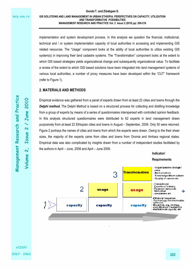
1.1. Analytical framework
The analysis is done within the context of the Capacity, Usage and Transformation (CUT) framework (Figure
1). Implicit in the framework is that change or transformation in land management can only be effected if
capacity is built (through the acquisition of GIS hardware and software) and if that capacity if appropriately
utilized to yield value. The capacity building process examines challenges and prospects in both the
Gondo T. and Zibabgwe S.
GIS SOLUTIONS AND LAND MANAGEMENT IN URBAN ETHIOPIA. PERSPECTIVES ON CAPACITY, UTILIZATION AND TRANSFORMATIVE POSSIBILITIES
MANAGEMENT RESEARCH AND PRACTICE Vol. 2 Issue 2 (2010) pp: 200-216
202
Management Research and Practice
Volum
e 2, Issue 2 / June 2010
eISSN
2067- 2462
mrp.ase.ro
implementation and system development process. In this analysis we question the financial, institutional,
technical and / or system implementation capacity of local authorities in accessing and implementing GIS
related resources. The “Usage” component looks at the ability of local authorities to utilize existing GIS
system(s) in improving their land cadastre systems. The “Transformation” component looks at the extent to
which GIS based strategies yields organizational change and subsequently organizational value. To facilitate
a review of the extent to which GIS based solutions have been integrated into land management systems of
various local authorities, a number of proxy measures have been developed within the “CUT” framework
(refer to Figure 1).
2. MATERIALS AND METHODS
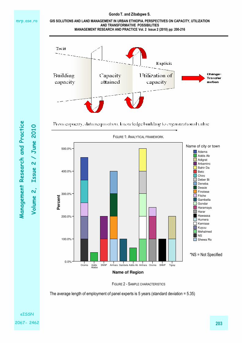
Empirical evidence was gathered from a panel of experts drawn from at least 22 cities and towns through the
Delphi method. The Delphi Method is based on a structured process for collecting and distilling knowledge
from a group of experts by means of a series of questionnaires interspersed with controlled opinion feedback.
In this analysis structured questionnaires were distributed to 62 experts in land management drawn
purposively from at least 22 Ethiopian cities and towns in August – September, 2009. Only 50 were returned.
Figure 2 portrays the names of cities and towns from which the experts were drawn. Owing to the their sheer
sizes, the majority of the experts came from cities and towns from Oromia and Amhara regional states.
Empirical data was also complicated by insights drawn from a number of independent studies facilitated by
the authors in April – June, 2008 and April – June 2009.
.
Indicator/
Requirements
Gondo T. and Zibabgwe S.
GIS SOLUTIONS AND LAND MANAGEMENT IN URBAN ETHIOPIA. PERSPECTIVES ON CAPACITY, UTILIZATION AND TRANSFORMATIVE POSSIBILITIES
MANAGEMENT RESEARCH AND PRACTICE Vol. 2 Issue 2 (2010) pp: 200-216
203
Management Research and Practice
Volum
e 2, Issue 2 / June 2010
eISSN
2067- 2462
mrp.ase.ro
FIGURE 1: ANALYTICAL FRAMEWORK.
Name of Region
TigraySNNPOromiaAmharaAddis AbGambelaAmharaSNNPAddis Ababa
Oromia
Perc
en
t
500.0%
400.0%
300.0%
200.0%
100.0%
0.0%
Shewa Ro
NS
Mehalmed
Kuyuu
Kemisse
Humera
Hawassa
Harar
Haramaya
Gondar
Gambella
Fitche
Finotese
Dessie
Deneba
Deber Bi
Chiro
Beto
Bahir Da
Arbaminc
Adigrat
Addis Ab
Adama
Name of city or town
FIGURE 2 - SAMPLE CHARACTERISTICS
The average length of employment of panel experts is 5 years (standard deviation = 5.35)
*NS = Not Specified

Gondo T. and Zibabgwe S.
GIS SOLUTIONS AND LAND MANAGEMENT IN URBAN ETHIOPIA. PERSPECTIVES ON CAPACITY, UTILIZATION AND TRANSFORMATIVE POSSIBILITIES
MANAGEMENT RESEARCH AND PRACTICE Vol. 2 Issue 2 (2010) pp: 200-216
204
Management Research and Practice
Volum
e 2, Issue 2 / June 2010
eISSN
2067- 2462
mrp.ase.ro
3. RESULTS AND DISCUSSION
3.1. Realities
Most Ethiopian urban centres grapple with informal land markets and developments a phenomenon
prevailing in most third world where, since the 1950s, 70-95% of all new housing built in developing countries
are unplanned or have been developed on land acquired informally (Farvacque and McAuslan, 1992) and the
trend does not show any sign of slowing down (UN-Habitat, 2003; Davis, 2004). As significant proportion of
urban development occurs outside the official purview of planning while the long term benefits of planned
settlements are recognized. To this problem urban/town planning acts & reacts on existing slums in a manner
that fails to capture and incorporate preventative and proactive measures that could reduce the spread of
future slum growth and ultimately mitigate the effects of unplanned settlements on the majority of urban
dwellers in developing countries (Sietchiping, 2005). This is particularly pertinent in the urban fringe where
informal subdivision processes outpace slow formal expropriation processes which when they materialize,
they find the land already occupied informally and there voices calling for regularization or formalization as
shown below.
Spatial extent of informal settlements when plans for masterplan boundary expansion commences
Spatial extent of informal settlements when plans for masterplan boundary expansion are approved
FIGURE 3 - SCHEMATIC OF INFORMAL LAND DEVELOPMENT IN THE URBAN FRINGE
Eight out of the 22 sampled towns and / cities (that 36 %) are already running a GIS based land management
system (Table 1). These include, but are not limited to cities such as Addis Ababa, Adama, Adiggrat, Bahir
Dar, Dessie, Gondar, Humera and Chiro town. Of the remaining 14 towns (64%) and / or cities plans were

Gondo T. and Zibabgwe S.
GIS SOLUTIONS AND LAND MANAGEMENT IN URBAN ETHIOPIA. PERSPECTIVES ON CAPACITY, UTILIZATION AND TRANSFORMATIVE POSSIBILITIES
MANAGEMENT RESEARCH AND PRACTICE Vol. 2 Issue 2 (2010) pp: 200-216
205
Management Research and Practice
Volum
e 2, Issue 2 / June 2010
eISSN
2067- 2462
mrp.ase.ro
said to be underway to introduce a GIS based land management system in 3 (14%) cities, including
Arbaminch, Hawassa and Shewa Robit. Absence of a GIS based land management system was
acknowledged in 10 (45%) other cities and / towns (refer to table 1). Two officials from Gambella city (5%)
were not sure whether the GIS based system existed. The analysis reveals that the majority of the sampled
towns and / or cities are not running a GIS based land management system. In all of the cases where the
system existed, it was acknowledged that the GIS applications in land management were not effectively
delivering the desired results owing to a multitude of constraints relating to capacity, the utilization of GIS
resources and the management of system development process. These shall be reviewed in later sections.
As a result of the absence of a GIS based land management system and the poorly function GIS systems in
some towns and cities, it is not surprising that the various facets of the land management process have not
benefited much (Figure 3 and 4). For example, 62% and 60% of the panel experts reiterated that the land
acquisition and land subdivision processes (respectively) of their respective local authorities had not
benefited much from GIS based solutions (Figure 3).
TABLE 1: EXISTENCE OF A GIS BASED LAND MANAGEMENT SYSTEM.
Does the LA run a GIS based land management system?
Don't knowNo, but plans underway
No, not at allYes, but..Yes
Percen
t
50.0%
40.0%
30.0%
20.0%
10.0%
0.0%
Aggregated statistics reveal that the majority (46%)
of the sampled panel experts acknowledged the
nonexistence of a GIS based land management
system. 34 % however acknowledged existence but
were not happy with its effectiveness. Only 1 panel
expert (2%) was content with the existence of a GIS
based land management in Addis Ababa. 14 % of
the experts said plans were underway to introduce a
GIS based land management system. The rest (4%)
DOES THE LA RUN A GIS BASED LAND MANAGEMENT SYSTEM?COUNT
Does the LA run a GIS based land management system?
Total
City/Town Yes Yes, but..
No, not at all
No, but plans
underway
Don't know
Count
Adam 0 1 0 0 0 1
Addis 1 4 0 0 0 5
Adigra 0 2 0 0 0 2
Arbam 0 0 0 2 0 2
Bahir 0 2 0 0 0 2
Beto 0 0 2 0 0 2
Chiro 0 2 0 0 0 2
Deber 0 0 1 0 0 1
Deneb 0 0 1 0 0 1
Dessi 0 2 0 0 0 2
Finote 0 0 2 0 0 2
Fitche 0 0 5 0 0 5
Gamb 0 0 0 0 2 2
Gonda 0 2 0 0 0 2
Haram 0 0 2 0 0 2
Harar 0 0 2 0 0 2
Hawa 0 0 0 3 0 3
Humer 0 2 0 0 0 2
Kemis 0 0 2 0 0 2
Kuyuu 0 0 2 0 0 2
Mehal 0 0 1 0 0 1
NS 0 0 3 0 0 3
Shew 0 0 0 2 0 2
Total 1 17 23 7 2 50
Gondo T. and Zibabgwe S.
GIS SOLUTIONS AND LAND MANAGEMENT IN URBAN ETHIOPIA. PERSPECTIVES ON CAPACITY, UTILIZATION AND TRANSFORMATIVE POSSIBILITIES
MANAGEMENT RESEARCH AND PRACTICE Vol. 2 Issue 2 (2010) pp: 200-216
206
Management Research and Practice
Volum
e 2, Issue 2 / June 2010
eISSN
2067- 2462
mrp.ase.ro
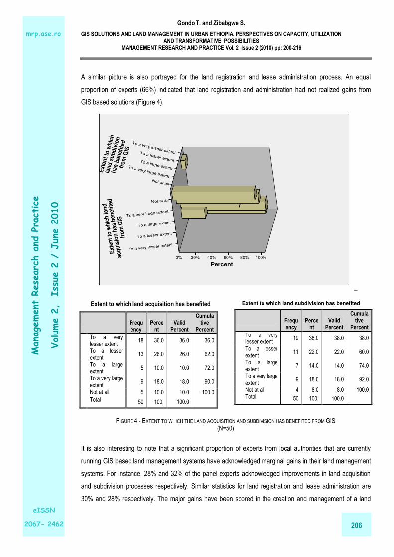
A similar picture is also portrayed for the land registration and lease administration process. An equal
proportion of experts (66%) indicated that land registration and administration had not realized gains from
GIS based solutions (Figure 4). E
xten
t to
wh
ich
la
nd
su
bd
ivio
n
has
ben
efit
ed
fro
m G
IS
Not at all
To a very large extent
To a large extent
To a lesser extent
To a very lesser extent
Percent
100%80%60%40%20%0%
Ext
ent
to w
hic
h la
nd
acq
uis
ion
ha
s b
enef
ited
fro
m G
IS
Not at all
To a very large extent
To a large extent
To a lesser extent
To a very lesser extent
_
FIGURE 4 - EXTENT TO WHICH THE LAND ACQUISITION AND SUBDIVISION HAS BENEFITED FROM GIS (N=50)
It is also interesting to note that a significant proportion of experts from local authorities that are currently
running GIS based land management systems have acknowledged marginal gains in their land management
systems. For instance, 28% and 32% of the panel experts acknowledged improvements in land acquisition
and subdivision processes respectively. Similar statistics for land registration and lease administration are
30% and 28% respectively. The major gains have been scored in the creation and management of a land
Extent to which land acquisition has benefited
Frequency
Percent
Valid Percent
Cumulative
Percent
To a very lesser extent
18 36.0 36.0 36.0
To a lesser extent
13 26.0 26.0 62.0
To a large extent
5 10.0 10.0 72.0
To a very large extent
9 18.0 18.0 90.0
Not at all 5 10.0 10.0 100.0
Total 50 100. 100.0
Extent to which land subdivision has benefited
Frequency
Percent
Valid Percent
Cumulative
Percent
To a very lesser extent
19 38.0 38.0 38.0
To a lesser extent
11 22.0 22.0 60.0
To a large extent
7 14.0 14.0 74.0
To a very large extent
9 18.0 18.0 92.0
Not at all 4 8.0 8.0 100.0 Total 50 100. 100.0
Gondo T. and Zibabgwe S.
GIS SOLUTIONS AND LAND MANAGEMENT IN URBAN ETHIOPIA. PERSPECTIVES ON CAPACITY, UTILIZATION AND TRANSFORMATIVE POSSIBILITIES
MANAGEMENT RESEARCH AND PRACTICE Vol. 2 Issue 2 (2010) pp: 200-216
207
Management Research and Practice
Volum
e 2, Issue 2 / June 2010
eISSN
2067- 2462
mrp.ase.ro
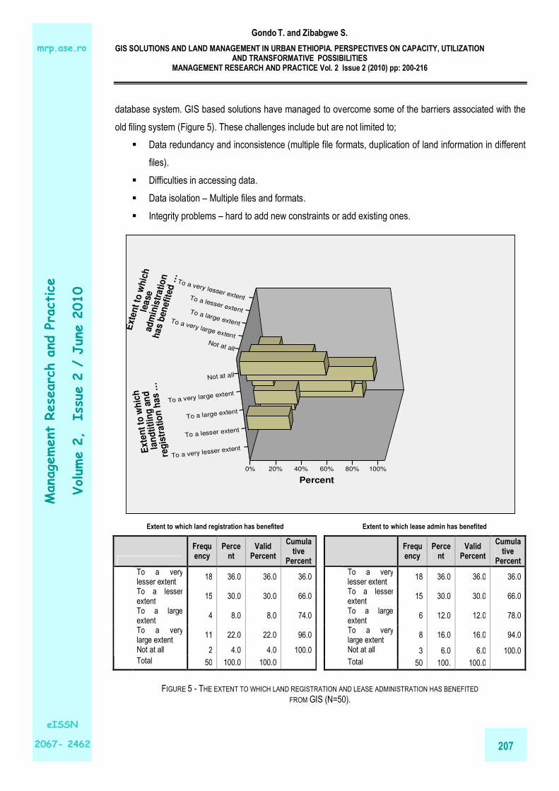
database system. GIS based solutions have managed to overcome some of the barriers associated with the
old filing system (Figure 5). These challenges include but are not limited to;
� Data redundancy and inconsistence (multiple file formats, duplication of land information in different
files).
� Difficulties in accessing data.
� Data isolation – Multiple files and formats.
� Integrity problems – hard to add new constraints or add existing ones.
Ext
en
t to
wh
ich
le
ase
ad
min
istr
ati
on
h
as
ben
efit
ed …
Not at all
To a very large extent
To a large extent
To a lesser extent
To a very lesser extent
Percent
100%80%60%40%20%0%
Exte
nt
to w
hic
h
lan
dti
tlin
g a
nd
reg
istr
ati
on
has …
Not at all
To a very large extent
To a large extent
To a lesser extent
To a very lesser extent
FIGURE 5 - THE EXTENT TO WHICH LAND REGISTRATION AND LEASE ADMINISTRATION HAS BENEFITED
FROM GIS (N=50).
Extent to which land registration has benefited
Frequency
Percent
Valid Percent
Cumulative
Percent
To a very lesser extent
18 36.0 36.0 36.0
To a lesser extent
15 30.0 30.0 66.0
To a large extent
4 8.0 8.0 74.0
To a very large extent
11 22.0 22.0 96.0
Not at all 2 4.0 4.0 100.0
Total 50 100.0 100.0
Extent to which lease admin has benefited
Frequency
Percent
Valid Percent
Cumulative
Percent
To a very lesser extent
18 36.0 36.0 36.0
To a lesser extent
15 30.0 30.0 66.0
To a large extent
6 12.0 12.0 78.0
To a very large extent
8 16.0 16.0 94.0
Not at all 3 6.0 6.0 100.0
Total 50 100. 100.0

Gondo T. and Zibabgwe S.
GIS SOLUTIONS AND LAND MANAGEMENT IN URBAN ETHIOPIA. PERSPECTIVES ON CAPACITY, UTILIZATION AND TRANSFORMATIVE POSSIBILITIES
MANAGEMENT RESEARCH AND PRACTICE Vol. 2 Issue 2 (2010) pp: 200-216
208
Management Research and Practice
Volum
e 2, Issue 2 / June 2010
eISSN
2067- 2462
mrp.ase.ro
� Atomicity of updates – land database often left in an inconsistent state with partial updates being
carried out.
� Challenges relating to concurrent access by multiple users – uncontrolled concurrent access often
leading to inconsistencies.
� Data security problems.
Though to varying extents, the development of GIS based database systems have in most cases offered
solutions to the above problems through,
� Controlling redundancy in data storage and in development and maintenance efforts.
� Sharing of data among multiple users.
� Restricting unauthorized access to data.
� Providing multiple interfaces to different classes of users.
� Representing complex relationships among data (in almost all the sample cases this has been
achieved through the use of relational data base models).
� Enforcing integrity constraints on land databases.
� Flexibility to change data structures.
� Availability of up to date information.
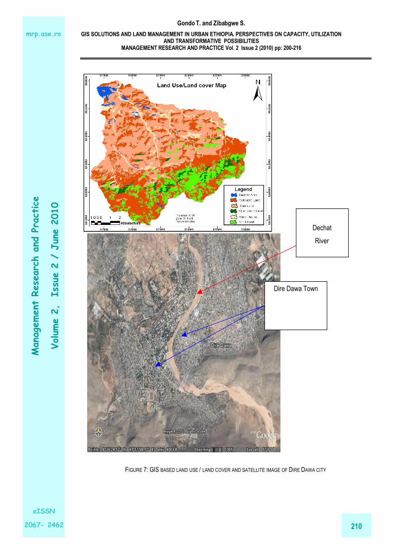
GIS mapping solutions (such as the one shown in Figure 6) have necessitated the tracking land use, property
and / or real estate changes in space and time. In Amhara Regional State general and more specifically in
Bahir Dar city GIS has permitted the identification and definition of major attributes of properties and or
parcels of land that are incorporated in the city owing to the inevitable expansion of city boundaries. Table 2
shows a sniper of major attributes in GIS database in the regional state.
FIGURE 6 - OLD MULTIPLE FILING SYSTEM IN ABIY ADDI MUNICIPALITY, ETHIOPIA. Source: Abiy Addi Municipality archive, 2008

Gondo T. and Zibabgwe S.
GIS SOLUTIONS AND LAND MANAGEMENT IN URBAN ETHIOPIA. PERSPECTIVES ON CAPACITY, UTILIZATION AND TRANSFORMATIVE POSSIBILITIES
MANAGEMENT RESEARCH AND PRACTICE Vol. 2 Issue 2 (2010) pp: 200-216
209
Management Research and Practice
Volum
e 2, Issue 2 / June 2010
eISSN
2067- 2462
mrp.ase.ro
TABLE 2 - MAJOR ATTRIBUTES IN GIS DATABASE IN AMHARA NATIONAL REGIONAL STATE, ETHIOPIA
Contents of a parcel data (Source; Amhara National Regional State Bureau of Works and Urban Development, 2008)
3.2. Challenges
Mainstreaming GIS based mapping solutions into the land management system of many local authorities in
Ethiopia has been constrained by many factors. We shall consider these within the “CUT” analytical
framework.
Capacity
The capacity of many local authorities to acquire and effectively implement a GIS based land management
system has been severely tainted by an overwhelming number of factors. Chief among these is inadequate
financial resources to procure the much needed GIS technologies (Both hardware and software). It is only
those few local authorities Like Addis Ababa, Adama City, Bahir Dar etc. that have managed to receive
financial and technical assistance from a number of organizations, including the federal government of
Ethiopia and GTZ just mention a few. Other small towns and cities have not taken an initiative and are
waiting for such initiatives to be extended to them in the near or distant future. The constrained access to and
utilization of GIS hardware such as computers is given in Figure 7.
Gondo T. and Zibabgwe S.
GIS SOLUTIONS AND LAND MANAGEMENT IN URBAN ETHIOPIA. PERSPECTIVES ON CAPACITY, UTILIZATION AND TRANSFORMATIVE POSSIBILITIES
MANAGEMENT RESEARCH AND PRACTICE Vol. 2 Issue 2 (2010) pp: 200-216
210
Management Research and Practice
Volum
e 2, Issue 2 / June 2010
eISSN
2067- 2462
mrp.ase.ro
Dechat
River
Dire Dawa Town
FIGURE 7: GIS BASED LAND USE / LAND COVER AND SATELLITE IMAGE OF DIRE DAWA CITY
Gondo T. and Zibabgwe S.
GIS SOLUTIONS AND LAND MANAGEMENT IN URBAN ETHIOPIA. PERSPECTIVES ON CAPACITY, UTILIZATION AND TRANSFORMATIVE POSSIBILITIES
MANAGEMENT RESEARCH AND PRACTICE Vol. 2 Issue 2 (2010) pp: 200-216
211
Management Research and Practice
Volum
e 2, Issue 2 / June 2010
eISSN
2067- 2462
mrp.ase.ro
Computer ownership statistics are 42%, 44%, 10% and 4% for very low, low, fair and high response
categories respectively. The fact that about 86% of the panel experts are acknowledging a generally low level
of computer ownership in their respective local authorities means that implementing and effectively running a
GIS based land management system is a daunting task for many. The situation looks dire when one
considers the level of utilization of available few computers (Figure 7). Computer utilization statistics are 52%,
36%, 8% and 4% for the very low, low, fair and high response categories respectively. Computer usage has
been construed by the general lack of expertise among the employees, and a lack of regular repairs on
mulfunctional computer equipment. Lack of expertise has seen many local authorities who have been
privileged enough to access some major developments in system software for the management of land and
land related assets failing to realize potential value (Figure 8). Other capacity related charges are institutional
in nature. In some urban centers such as Adama, The GIS system implementation process has not been
streamlined into vision of the local authority through a clear know organizational strategy. This coupled with
technical errors in the implementation process as well as a lack of proper coordination among different
departments and a lack of commitment by some officials has rendered the whole system ineffective and
inefficient. Even in those administrations such as Addis Ababa where the organizational strategy is clear, the
strategy has not been effectively communicated to all relevant employees and this has negatively affected all
efforts targeted at achieving commonality in objectives.
General level of
computer usage
Very
low
Low Fair High
Pe
rce
nt
100%
80%
60%
40%
20%
0%
General level of computer ownership
Very low
LowFair
High
FIGURE 8 - PERCEIVED LEVEL OF COMPUTER OWNERSHIP AND USAGE (N=50)

Gondo T. and Zibabgwe S.
GIS SOLUTIONS AND LAND MANAGEMENT IN URBAN ETHIOPIA. PERSPECTIVES ON CAPACITY, UTILIZATION AND TRANSFORMATIVE POSSIBILITIES
MANAGEMENT RESEARCH AND PRACTICE Vol. 2 Issue 2 (2010) pp: 200-216
212
Management Research and Practice
Volum
e 2, Issue 2 / June 2010
eISSN
2067- 2462
mrp.ase.ro
Which GIS based system softwares has been employed to manage land assets?
Don't knowNoneCityworksSynergen
Perc
en
t
1200.0%
1000.0%
800.0%
600.0%
400.0%
200.0%
0.0%
Shewa Ro
NS
Mehalmed
Kuyuu
Kemisse
Humera
Hawassa
Harar
Haramaya
Gondar
Gambella
Fitche
Finotese
Dessie
Deneba
Deber Bi
Chiro
Beto
Bahir Da
Arbaminc
Adigrat
Addis Ab
Adama
Name of city or town
FIGURE 9 - GIS BASED SYSTEM SOFTWARE THAT HAS BEEN ACCESSED BY A SAMPLE OF CITIES / TOWNS (N=50).
Usage
The utilization of GIS resources has been constrained by such factors as lack of commitment, lack of skilled
manpower, absence of incentives to motivate workers and a general lack of awareness of the utility of GIS
resources in land management. Training programmes initiated in a few cities and towns have been limited to
few people owing to financial constraints. The sheer small numbers of hardware components that exist in
many local authorities has not helped the situation.
Transformation
Fostering organizational change that yields organizational value in the land management process has been
difficult in many cities and towns owing to constraints characterizing capacity and usage. As a result service
delivery has remained relatively low (Table 3)
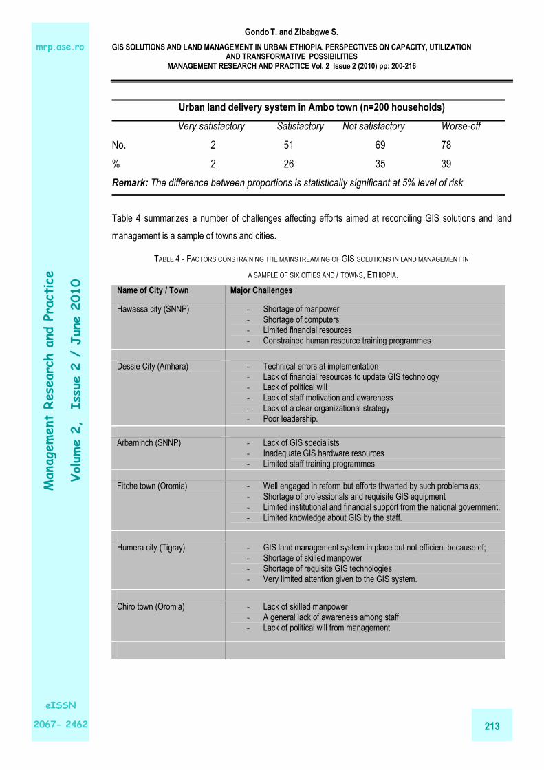
TABLE 3 - EFFECTIVENESS OF THE LAND DELIVERY SYSTEMS OF TWO SAMPLE TOWNS
Urban land delivery system in Nekemte town (n = 150 households)
Very satisfactory Satisfactory Not satisfactory
No. 15 45 90
% 10 30 60
Remark: The difference between proportions is statistically significant at 5% level of risk
Gondo T. and Zibabgwe S.
GIS SOLUTIONS AND LAND MANAGEMENT IN URBAN ETHIOPIA. PERSPECTIVES ON CAPACITY, UTILIZATION AND TRANSFORMATIVE POSSIBILITIES
MANAGEMENT RESEARCH AND PRACTICE Vol. 2 Issue 2 (2010) pp: 200-216
213
Management Research and Practice
Volum
e 2, Issue 2 / June 2010
eISSN
2067- 2462
mrp.ase.ro
Urban land delivery system in Ambo town (n=200 households)
Very satisfactory Satisfactory Not satisfactory Worse-off
No. 2 51 69 78
% 2 26 35 39
Remark: The difference between proportions is statistically significant at 5% level of risk
Table 4 summarizes a number of challenges affecting efforts aimed at reconciling GIS solutions and land
management is a sample of towns and cities.
TABLE 4 - FACTORS CONSTRAINING THE MAINSTREAMING OF GIS SOLUTIONS IN LAND MANAGEMENT IN
A SAMPLE OF SIX CITIES AND / TOWNS, ETHIOPIA.
Name of City / Town Major Challenges
Hawassa city (SNNP) - Shortage of manpower - Shortage of computers - Limited financial resources - Constrained human resource training programmes
Dessie City (Amhara) - Technical errors at implementation - Lack of financial resources to update GIS technology - Lack of political will - Lack of staff motivation and awareness - Lack of a clear organizational strategy - Poor leadership.
Arbaminch (SNNP) - Lack of GIS specialists - Inadequate GIS hardware resources - Limited staff training programmes
Fitche town (Oromia) - Well engaged in reform but efforts thwarted by such problems as; - Shortage of professionals and requisite GIS equipment - Limited institutional and financial support from the national government. - Limited knowledge about GIS by the staff.
Humera city (Tigray) - GIS land management system in place but not efficient because of; - Shortage of skilled manpower - Shortage of requisite GIS technologies - Very limited attention given to the GIS system.
Chiro town (Oromia) - Lack of skilled manpower - A general lack of awareness among staff - Lack of political will from management
Gondo T. and Zibabgwe S.
GIS SOLUTIONS AND LAND MANAGEMENT IN URBAN ETHIOPIA. PERSPECTIVES ON CAPACITY, UTILIZATION AND TRANSFORMATIVE POSSIBILITIES
MANAGEMENT RESEARCH AND PRACTICE Vol. 2 Issue 2 (2010) pp: 200-216
214
Management Research and Practice
Volum
e 2, Issue 2 / June 2010
eISSN
2067- 2462
mrp.ase.ro
4. RECOMMENDATIONS
The effective implementation of GIS based solutions in Ethiopia requires that the following issues are
addressed;
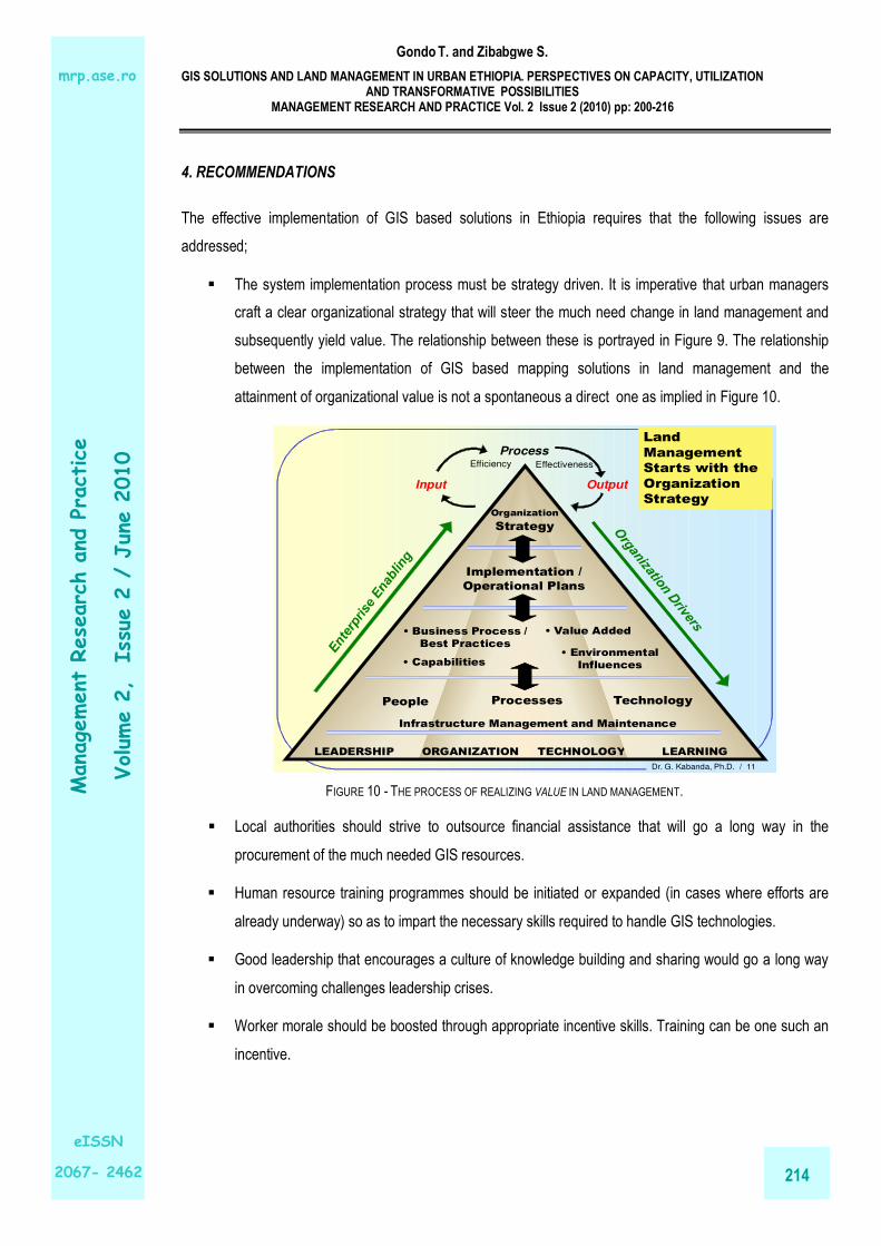
� The system implementation process must be strategy driven. It is imperative that urban managers
craft a clear organizational strategy that will steer the much need change in land management and
subsequently yield value. The relationship between these is portrayed in Figure 9. The relationship
between the implementation of GIS based mapping solutions in land management and the
attainment of organizational value is not a spontaneous a direct one as implied in Figure 10.
Dr. G. Kabanda, Ph.D. / 11
LEADERSHIP ORGANIZATION TECHNOLOGY LEARNING
People Processes Technology
Infrastructure Management and Maintenance
Organization
Strategy
Implementation /
Operational Plans
• Business Process /
Best Practices
• Capabilities• Environmental
Influences
• Value Added
Input
Process
Output
Efficiency Effectiveness
Land
Management
Starts with the
Organization
Strategy
FIGURE 10 - THE PROCESS OF REALIZING VALUE IN LAND MANAGEMENT.
� Local authorities should strive to outsource financial assistance that will go a long way in the
procurement of the much needed GIS resources.
� Human resource training programmes should be initiated or expanded (in cases where efforts are
already underway) so as to impart the necessary skills required to handle GIS technologies.
� Good leadership that encourages a culture of knowledge building and sharing would go a long way
in overcoming challenges leadership crises.
� Worker morale should be boosted through appropriate incentive skills. Training can be one such an
incentive.

Gondo T. and Zibabgwe S.
GIS SOLUTIONS AND LAND MANAGEMENT IN URBAN ETHIOPIA. PERSPECTIVES ON CAPACITY, UTILIZATION AND TRANSFORMATIVE POSSIBILITIES
MANAGEMENT RESEARCH AND PRACTICE Vol. 2 Issue 2 (2010) pp: 200-216
215
Management Research and Practice
Volum
e 2, Issue 2 / June 2010
eISSN
2067- 2462
mrp.ase.ro
� General awareness can be raised by initially opening up intra-organizational channels of
communication. The ideal starting point would be to communicate the local authority’s strategy to all
employees regarding the implementation of a new GIS system for land management.
� Need to go beyond the static GIS outputs through complimenting it with other techniques that have
simulation and modeling capabilities to help predict future informal settlement expansion areas so
that cities adopt preventive urban land management practices.
5. CONCLUSIONS
The reality is that the status of GIS for land management in most cities is that of constrained capacity, usage
and transformation. Capacity related challenges include inadequate financial resources to procure requisite
GIS infrastructure. Lack of implementation capacity, lack of a clear organizational strategy and a general lack
of political will among officials are some of the capacity constraints. The utilization of GIS technologies has
been constrained by the sheer small numbers of GIS resources (both hardware and software) characterizing
many local authorities. Inadequate GIS infrastructure maintenance schemes and lack of computer knowledge
are some of the bottlenecks that have seen the constrained utilization of GIS resources. The analysis also
reveals that access to GIS system software does not automatically translate to the attainment of
organizational value. Instead, it enables the formulation and realization of organizational strategy that will
direct organizational change and subsequently lead to increased organizational value. This however requires
the fixing of challenges relating to finance, technical expertise, institutional arrangements and the
implementation process.
ACKNOWLEDGEMENT
The authors acknowledge the invaluable contribution made by a panel of experts fro a number of Ethiopian
towns and / or cities. We also acknowledge the institutional support rendered by the Ethiopian Civil Service
College through its Worldbank / UNDP funded urban management masters programme, and the University of
Venda through the department of Regional and Urban Planning. We also acknowledge the support rendered
by ESRI, through the 4th ESRI Eastern Africa User Conference, 24 – 25 September, 2009, held at the United
Nations Conference Centre, Addis Ababa, Ethiopia where the paper ideas were presented. The views
expressed here are however the sole responsibility of the authors and not for the supporting institutions.
REFERENCES
Abbiy Addi Municipality. (2008) Municipality archive files.
Amhara National Regional State Bureau of Works and Urban Development (2008). A Manual for the Preparation of Cadastre for Urban Centres of the ANRS, Bahir Dar, Ethiopia.

Gondo T. and Zibabgwe S.
GIS SOLUTIONS AND LAND MANAGEMENT IN URBAN ETHIOPIA. PERSPECTIVES ON CAPACITY, UTILIZATION AND TRANSFORMATIVE POSSIBILITIES
MANAGEMENT RESEARCH AND PRACTICE Vol. 2 Issue 2 (2010) pp: 200-216
216
Management Research and Practice
Volum
e 2, Issue 2 / June 2010
eISSN
2067- 2462
mrp.ase.ro
Davis, M. (2004). Planet of Slums. Urban involution and the informal proletariat. New Left Review 26, March 2004, pp. 5-34.
Farvacque, C. and McAuslan, P. (1992). Reforming Urban Land Policies and Institutions in Developing Countries, World bank, Washington D.C.
Masser, I. (2005). GIS worlds: Creating Spatial Data Infrastructure. Pg 9. Carlifonia: ESRI Press
Melkamu, B.M. (2009). Growing Initiatives for the improvement of cadastre in Urban Amhara: Potentials, Prospects, Challenges. Eilat, Israel.
Opoku-Mensah, A. and Salih, M.A.M. (2007). African e-markets: Information and economic development. Economic Commission For Africa. Centre for African Studies, Copenhagen University and International books.
Sietchiping, R. (2005). Prospective Slum Policies: Conceptualization and Implementation of a Proposed Informal Settlement Growth Model, Third Urban Research Symposium On Land Development, Urban Policy And Poverty Reduction, 4-6 April 2005, Brasilia, Df, Brazil.
UN-Habitat (United Nations-Habitat) (2003). The challenge of slums: global report on human settlements 2003. London: Earthscan.