Embed Size (px)
Citation preview
177
Geomorphometry.org/2015
Multidimensional approach to natural instabilities in
mountain areas: how geomorphometry can improve
both hazard modeling and risk perception
Marco Giardino
Earth Sciences Department and NatRisk Centre
University of Torino
Torino, Italy
Luigi Perotti
Visiting scientist at Earth Sciences Department
Simon Fraser University
Burnaby, Canada
Walter Alberto
ImaGEO srl
Spin off Company University of Torino
Torino, Italy
Sara Ratto
Centro Funzionale
Regione Autonoma Valle d’Aosta
Aosta, Italy
Abstract—On going climatic and environmental changes have
increasing impacts on infrastructure and human activities within
mountain areas. Improvements are needed for both accurate
hazards modelling and targeted risks management through
diffusion of scientific results. By means of the application of a
multidimensional approach (local, regional) to natural hazards and
risks case studies of the European Alps, the paper shows the
strategic roles played by geomorphometric tools and methods
(accurate DEM derived data and targeted geomatics analytical
tools) for both enhanced accuracy of models of diverse
geoenvironmental processes and improved knowledge on natural
hazards and awareness on natural risks in mountain areas.
I. INTRODUCTION
Natural hazards and risks assessment in mountain areas is a challenging issue because of ongoing environmental changes associated with climate change and increasing impacts on infrastructure and socio‐economic and cultural activities. Since behavior of mountain communities towards natural hazards is mostly influenced by "perceived risk” than "real risk”, research should be addressed both to accurate hazards modelling and targeted applications of new technologies for diffusion of scientific results. This could improve the share of information among people, reaching for a larger and deeper corpus of knowledge about natural hazards and risk related policies [1]. By means of assessment of DEM derived data and selection of geomatics analytical tools, geomorphometry can be useful for
both 1) enhanced accuracy of models of diverse geoenvironmental processes of mountain regions and 2) improved “targeted” knowledge on natural hazards and increased awareness on natural risks.
II. AIMS AND METHODS
A. Multidimensional Approach to natural hazards
A diversity of information on natural hazards is available for the Alpine region, including different types of data and models by contents, quality, and dimensions. Within our research, we updated geodatabases on natural instability phenomena of the Western Alps with new regional and local data, either by remote sensing or by field surveys. We applied geomorphometrical techniques, we interpreted data, then we summarized and redrawn results in order to create reports, base maps, models and/or more elaborated geothematic or statistical representations. Our challenges were not only to overcome technical difficulties of data management and interpretation, but also to make available new straightforward risk scenarios to decision-makers, and the citizens. For this purpose, a multiscale approach (Regional Geological, Local Morphodynamic) for collection, interpretation, and representation of data on natural hazards is here proposed.
1) Regional Geological Approach (RGA) focuses on mountain environmental systems as a whole, by addressing
Giardino et al.
In: Geomorphometry for Geosciences, Jasiewicz J., Zwoliński Zb., Mitasova H., Hengl T. (eds), 2015. Adam Mickiewicz University in Poznań
- Institute of Geoecology and Geoinformation, International Society for Geomorphometry, Poznań
178
the analysis of large-scale, long-term features related to natural hazards; these represent general factors of instabilities in the mountain relief (geomorphological, lithological and structural factors). RGA allows interpretation of: 1) evolutionary stages of the mountain relief; 2) regional independent variables, offering a “static”
conditioning to the mountain system (e.g. landslides: “internal” causes, lowering shear strength).
2) Local “Morphodynamic” Approach (LMA) focuses on single elements of the dynamic environmental system. It is the study of characteristic landforms and processes of natural instability of mountains, relevant for understanding mechanism of relief evolution and natural hazards. LMA allows to perform: 1) control on dynamic factors of natural instabilities (e.g. landslides “external” causes, increasing shear stress); 2) modelling of instability process and assessment of natural hazards.
B. Geomatics applications for Geomorphometry
In the last 10 years Geomatics opened up new methods for detailed Earth surface analysis and new potentials for data processing [2]: combining geodatabases and geomorphometry [3], geomorphosites identification, assessment and representation [4], geomorphological mapping [5] and remote sensing analysis of landforms within a GIS environment [6]. Our hypothesis is that the combination of geomatics with DEMs and LiDAR derived DTMs [7] can be successful for both geomorphometric studies on landforms within remote/inaccessible areas [8], and for 2.5D perspective views and simplified mapping of natural hazard studies in mountains. For this purpose, we aims to explore the scalability of data within multidimensional approaches. Even if both approaches need a reference DEM or DTM, RGA is focused on extension quality for good reference derived map for instabilities, while LGM needs best GSD and precision in order to derive real relief characteristics.
III. APPLICATIONS AND RESULTS
A. Regional Geological Approach
The Aosta Valley is the smallest Italian region (area: 3.262 km2) and one of the main alpine valley systems, whose elevations ranges from 400 m a.s.l. (valley’s mouth into the Po Plain) to 4810 m a.s.l. (Mount Blanc, the highest peak of the European Alps). It is a relatively densely populated area, characterized by international transport corridors to France and Switzerland, high geodiversity content and tourist attractiveness, thus representing an ideal test area for natural hazards and risk studies. In order to improve the understanding of landslide, debris flow and flood hazards in the Aosta Valley and to better face the risks they represent for this mountain area, a comprehensive study
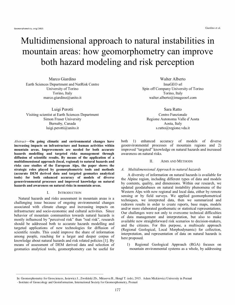
program (field researches, remote-sensing studies and historical data analysis) has been established by the Centro Funzionale and the Regional Geological survey of the Aosta valley. The University of Turin and Imageo organized a geodatabase, performed GIS mapping of monitored landslide at the regional and local scales. Neural network processing of high resolution hyperspectral MIVIS (Multispectral Infrared and Visible Imaging Spectrometer) images [9] produced orthoprojected maps of the whole Region for better definition of both lithotecnical properties (Figure 1) and geometry and state of activity of landslide (Figures 2 and 3). For the Regional Geological Approach to slope instabilities in the Aosta Valley, the DEM analysis has been coupled with interferometric assessment of terrain deformation by detection of permanent scatterers (PSInSAR techniques, [10].
Figure 1 – A portion of the lithotechnical map of the Aosta Valley in the Courmayeur district area, on the photogrammetric generated DEM (Digital Elevation Model) of the Region. Lithotecnical Units: 1) Massive igneous and metamorphic rocks; 2) Marble and other carbonatic massive rocks; 3) Carbonatic schist; 4) Fine-grained schist), 5) Pelitic-arenaceous-conglomeratic rocks; 6) Evaporitic rocks). Other Elements: a) Landslide accumulation; b) Alluvial deposits; c) Glacial deposits; d) slope debris; e) DSGSD: Deep-seated Gravitational Slope Deformation; f) Glaciers; g) Thrusts; h) Faults.
Giardino et al.Geomorphometry.org/2015
179
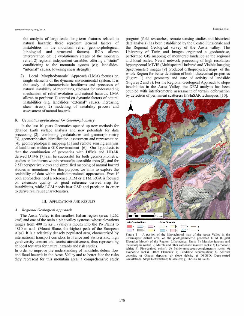
Close analysis of the Quart-Croce Fana DSGSD (Figure 2; middle Aosta Valley) reveals: up to 13 mm / year displacements along an active major scarp (A1), extensional, lower PS velocities (up to 8 mm / year) at A2; and a small area (D) corresponding to an active landslide.
B. Local Morphodynamic approach
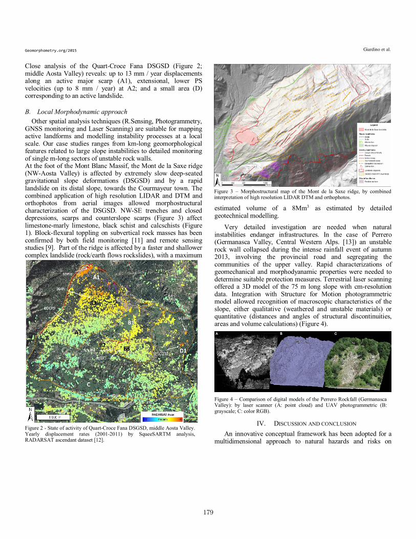
Other spatial analysis techniques (R.Sensing, Photogrammetry, GNSS monitoring and Laser Scanning) are suitable for mapping active landforms and modelling instability processes at a local scale. Our case studies ranges from km-long geomorphological features related to large slope instabilities to detailed monitoring of single m-long sectors of unstable rock walls. At the foot of the Mont Blanc Massif, the Mont de la Saxe ridge (NW-Aosta Valley) is affected by extremely slow deep-seated gravitational slope deformations (DSGSD) and by a rapid landslide on its distal slope, towards the Courmayeur town. The combined application of high resolution LIDAR and DTM and orthophotos from aerial images allowed morphostructural characterization of the DSGSD. NW-SE trenches and closed depressions, scarps and counterslope scarps (Figure 3) affect limestone-marly limestone, black schist and calcschists (Figure 1). Block-flexural toppling on subvertical rock masses has been confirmed by both field monitoring [11] and remote sensing studies [9]. Part of the ridge is affected by a faster and shallower complex landslide (rock/earth flows rockslides), with a maximum
estimated volume of a 8Mm3 as estimated by detailed geotechnical modelling.
Very detailed investigation are needed when natural instabilities endanger infrastructures. In the case of Perrero (Germanasca Valley, Central Western Alps. [13]) an unstable rock wall collapsed during the intense rainfall event of autumn 2013, involving the provincial road and segregating the communities of the upper valley. Rapid characterizations of geomechanical and morphodyanamic properties were needed to determine suitable protection measures. Terrestrial laser scanning offered a 3D model of the 75 m long slope with cm-resolution data. Integration with Structure for Motion photogrammetric model allowed recognition of macroscopic characteristics of the slope, either qualitative (weathered and unstable materials) or quantitative (distances and angles of structural discontinuities, areas and volume calculations) (Figure 4).
Figure 4 – Comparison of digital models of the Perrero Rockfall (Germanasca Valley): by laser scanner (A: point cloud) and UAV photogrammetric (B: grayscale; C: color RGB).
IV. DISCUSSION AND CONCLUSION
An innovative conceptual framework has been adopted for a multidimensional approach to natural hazards and risks on
Figure 2 - State of activity of Quart-Croce Fana DSGSD, middle Aosta Valley. Yearly displacement rates (2001-2011) by SqueeSARTM analysis, RADARSAT ascendant dataset [12].
Figure 3 – Morphostructural map of the Mont de la Saxe ridge, by combined interpretation of high resolution LIDAR DTM and orthophotos.
Giardino et al.Geomorphometry.org/2015

180
mountain regions. Geomorphometric methodologies and geomatics technologies have been applied for both accurate hazards modelling and targeted risks management [14].
The results of the case studies in the Western Alps reinforced the validity of the interpretative key for an user-friendly classification of mountain hazards. Within the Regional Geological Approach (RGA), case studies of 10-100 km wide areas indicated satellite regional DEM/DTM (SRTM, ASTER) and related low to medium resolution multispectral images from optical sensors as the appropriate tools for assessing structural, lithological and geomorphological features as long term and large scale factors of natural hazards. Application of Differential Radar Interferometry techniques (PSInSAR) allowed to individualize areas of enhanced ground deformation; target monitoring, time series visualization and correlation to the regional context allowed better results in reconstructing the recent evolutionary stages of the mountain relief.
Following the spatial and temporal “sizes” of natural instabilities, it has been also possible to operate appropriate selections of geomatics techniques and geomorphometric products within the case studies related to the Local Morphodynamic Approach (LMA). Better results, both in hazard and risk assessments of 0,1-1 km geomorphological phenomena have been obtained by the application of LIDAR DTMs, hyperspectral and high resolution satellite images, close range photogrammetry and Laser Scanning.
Geomatics applications to geomorphometry go beyond the limit of classical geomorphological techniques. They both overcome the difficulty of quantitative analysis over large areas, and allow monitoring of small/slow instability markers; moreover, they can be efficient despite lack of direct field geomorphological evidences. This is of great importance in the knowledge about rates and distributions of instability phenomena.
Mountain regions have geological and geomorphological characteristics that make them very sensitive to climate changes. Moreover their geo-environmental characteristics are very attractive to tourism activities. Consequently, increased human “pressure” makes higher geomorphological risks, particularly related to slope instability phenomena.
REFERENCES
[1] Angignard, M., Garcia, C., Peters-Guarin, G., Greiving, S., 2014 “The relevance of legal aspects, risk cultures and insurance possibilities for risk
management” In: Mountain risks: from prediction to management and governance. Edited by: van Asch, T., Coronas, J., Grieving, S., Malet, J.P.,
Sterlacchini, S., Springer, 327-340. [2] Tarolli P., Arrowsmith J R., Vivoni E.R. 2009 “Understanding earth
surface processes from remotely sensed digital terrain models”. Geomorphology, 113: 1-3.
doi:http://dx.doi.org/10.1016/j.geomorph.2009.07.005.
[3] Bolongaro-Crevenna A., Torres-Rodriquez V., Sorani V., Frame D., Ortiz D.M.A. (2005) - Geomorphometric analysis for characterizing landforms
in Morelos State, Mexico. Geomorphology, 67: 407-422.
[4] Seijmonsbergen A.C., De Jong M.G.G., De Graaf L.W.S. (2009) - A method for the identification and assessment of significance of
geomorphosites in Vorarlberg (Austria), supported by Geographical Information Systems. Geografi Fisica e Dinamica Quaternaria. Mem.
Descr. Carta Geol. d It., LXXXVII, 163-172.
[5] Anders N.S., Seijmonsbergen A.C., Bouten W. (2009) - Multi-Scale and Object-Oriented Image Analysis of High-Res LiDAR Data for
Geomorphological Mapping in Alpine Mountains. Proceedings of Geomorphometry. Zurich, Switzerland, 31 August -2 September, 2009
[6] Siart C., Bubenzer O., Eitel B. (2009) - Combining digital elevation data
(SRTM/ASTER) high resolution satellite imagery (Quickbird) and GIS for geomorphological mapping: A multi-component case study on
Mediterranean karst in Central Crete. Geomorphology, 112 (1-2): 106-121. doi: http://dx.doi.org/10.1016/j.geomorph.2009.05.010
[7] Corona P., Cartisano R., Salvati R., Chirici G., Floris A., Di Martino P.,
Marchetti M., Scrinzi G., Clementel F., Travaglini D., Torresan C. (2012) - Airborne Laser Scanning to support forest resource management under
alpine, temperate and Mediterranean environments in Italy. European Journal of Remote Sensing, 45: 27-37. doi: http://
dx.doi.org/10.5721/EuJRS2012450.
[8] Lucchesi S., Giardino M., Perotti L. (2013) - Applications of high-
resolution images and DTMs for detailed geomorphological analysis of mountain and plain areas of NW Italy. European Journal of Remote
Sensing 46: 216-233. doi: http://dx.doi.org/10.5721/ EuJRS20134612.
[9] Giardino M., Borgogno Mondino E., Perotti L. (2004). MIVIS Images classification for the geomorphological characterization of large slope
instabilities in Aosta Valley (Italian NW-Alps), in In: Ehlers, M. Posa, F., Kaufmann, H.J., Michel, U., De Carolis, G.: “Remote Sensing for
Environmental Monitoring GIS applications and Geology”, Proceeding of S.P.I.E., vol 5574, 331-340.
[10] Ferretti A., Prati C., Rocca F., (2001) Permanent Scatterers in SAR
Interferometry. IEEE Trans. on Geoscience and Remote Sensing, Vol. 39, no. 1, pp. 8‐20
[11] Deline P., Gruber S., Delaloye R., Fischer L., Geertsema M., Giardino M.,
Hasler A., Kirkbride M., Krautblatter M., Magnin F., McColl S., Ravanel L., and Schoeneich P., 2015- Ice Loss and Slope Stability in High-
Mountain Regions. in Haeberli W. and Whiteman C. (Eds) 521-562. Snow and Ice-Related Hazards, Risks, and Disasters.
http://dx.doi.org/10.1016/B978-0-12-394849-6.00015-9
[12] Ferretti A., Fumagalli A., Novali F., Prati C., Rocca F., Rucci A., (2011) A new algorithm for processing interferometric data‐stacks: SqueeSAR.
To be published on IEEE Trans. Geosciences and Remote Sensing.
[13] Allasia P., Audisio C., Baldo M., Cirio C.G., Lollino G., Giordan D., Godone F., Nigrelli G., Alpe F., Ambrogio S., Giardino M., Perotti L.,
Sambuelli L., De Renzo G., Fontan D., Barbero T., 2004 - P41 - Instrumented experimental sites for the control of landslide hazards in
mountain environments: the Germanasca and Susa Valleys (NorthWestern Italy), In: Guerrieri, L., Rischia, I. & Serva, L. (Series Eds). Field Trip
Guide Books, 32nd International Geological Conference, Florence 20-28 Agosto 2004, Memorie Descrittive della Carta Geologica d'Italia, Vol.
LXIII (5), P - 41, APAT, Roma, 40 p.
[14] Giardino M., Perotti L., Lanfranco M., Perrone G. (2012) - GIS and
geomatics for disaster management and emergency relief: a proactive response to natural hazards. Applied Geomatics, 4 (1): 33-46. doi:
http://dx.doi.org/10.1007/s12518-011-0071-z.
Giardino et al.Geomorphometry.org/2015