Embed Size (px)
Citation preview

ac
e
b
d f
INVERNESS
A9
A9
PITLOCHRY
PERTH
PITLOCHRYSOUTH JUNCTION
PITLOCHRYNORTH JUNCTION
LOCHFASKALLY
RIVER TUMMEL HIGHLAND MAIN
LINE RAILWAY
RIVE
R GA
RRY
LOCHFASKALLY
739
733
732731
730
729
727
719
703
654 653651
643
641
639
321319
313
322 323
638
640
642
644
668
725
637
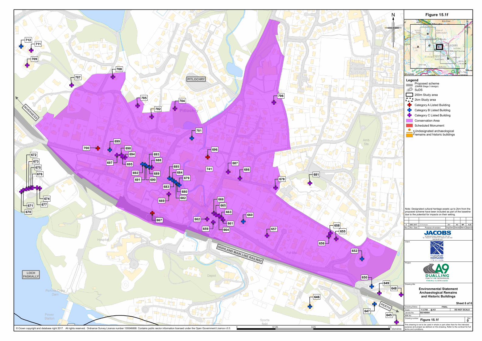
REFER TO SHEET 15.1f
© Crown copyright and database right 2017. All rights reserved. Ordnance Survey Licence number 100046668. Contains public sector information licensed under the Open Government Licence v3.0.
Figure 15.1a
?
N
Rev
Client
Project
Drawing title
Scale
Drawing number
Jacobs No.DO NOT SCALE@ A3
This drawing is not to be used in whole or part other than for the intendedpurpose and project as defined on this drawing. Refer to the contract for fullterms and conditions.
B2140004BIM No.
Rev. Rev. Date Purpose of revision Apprv'dRev'dCheckdOrig/Dwn
95 Bothwell Street, Glasgow, G2 7HX, UK.Tel: +44(0)141 243 8000 Fax:+44(0)141 226 3109
www.jacobs.com
Figure 15.1a
Environmental StatementArchaeological Remainsand Historic Buildings
0
JCrDEC 20170 ACES Publication
Drawing Status FINAL
MP AJG
Sheet 1 of 6
Legend
SuDS200m Study area2km Study area
GF Category A Listed BuildingGF Category B Listed BuildingGF Category C Listed Building
Conservation AreaScheduled Monument
0 1.5 3kilometres
Note: Designated cultural heritage assets up to 2km from theproposed scheme have been included as part of the baselinedue to the potential for impacts on their setting.
1:35,000
(DMRB Stage 3 design)Proposed scheme
GFGF GFGFGFGFGFGF
GF GFGFGF GFGF GFGF
GFGF
GFGFGFGFGF
GFGFGFGF
GFGF
723
722
721
718
717
716
715
714713
724
726728
720

PERTH
A9
INVERNESS
PITLOCHRY SOUTHJUNCTION
FOSS ROADUNDERBRIDGE
TUMMELUNDERBRIDGE
HIGHLAND MAINLINE RAILWAY
RIVER TUMMEL
640
638
271
264
258252
641
639
272
268
267265263
262261
260
259
254
252
792
ac
e
b
d f
© Crown copyright and database right 2017. All rights reserved. Ordnance Survey Licence number 100046668. Contains public sector information licensed under the Open Government Licence v3.0.
Figure 15.1b
?
N
Rev
Client
Project
Drawing title
Scale
Drawing number
Jacobs No.DO NOT SCALE@ A3
This drawing is not to be used in whole or part other than for the intendedpurpose and project as defined on this drawing. Refer to the contract for fullterms and conditions.
B2140004BIM No.
Rev. Rev. Date Purpose of revision Apprv'dRev'dCheckdOrig/Dwn
95 Bothwell Street, Glasgow, G2 7HX, UK.Tel: +44(0)141 243 8000 Fax:+44(0)141 226 3109
www.jacobs.com
Figure 15.1b
Environmental StatementArchaeological Remainsand Historic Buildings
0
JCrDEC 20170 ACES Publication
Drawing Status FINAL
MP AJG
Sheet 2 of 6
Legend
SuDS200m Study area2km Study area
GF Category A Listed BuildingGF Category B Listed BuildingGF Category C Listed Building
Conservation AreaScheduled Monument
}Undesignated archaeological remains and historic buildings
!(
0 0.5 1kilometres
1:10,000
Note: Designated cultural heritage assets up to 2km from theproposed scheme have been included as part of the baselinedue to the potential for impacts on their setting.
(DMRB Stage 3 design)Proposed scheme
PERTH
INVERNESS
PITLOCHRYLOCH
FASKALLY
C452 CLUNIE-FOSSUNDERBRIDGE
CLUNIEUNDERBRIDGE
PITLOCHRY
TUMMELUNDERBRIDGE
PITLOCHRY SOUTHJUNCTION
FOSS ROADUNDERBRIDGE
ROB ROY WAYUNDERPASS
RIVER TUMMELHIGHLAND MAIN LINE RAILWAY
713
668
306
271
264
258252
703
654653
651
643
289
305
304303
301
297
296295
293292 291
290288287
286 285284283
282
281
280278
275
274
273 272270
269268
267265263
262261
260
259
740
776
775
792
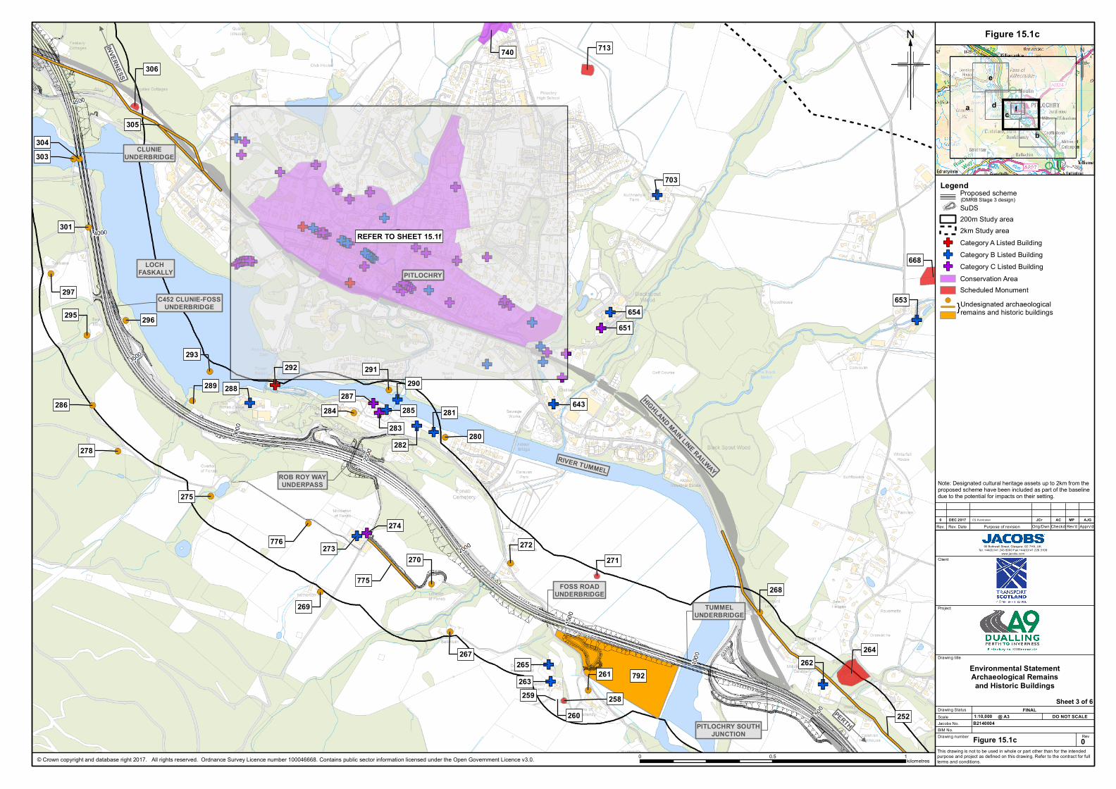
REFER TO SHEET 15.1f
ac
e
b
d f
© Crown copyright and database right 2017. All rights reserved. Ordnance Survey Licence number 100046668. Contains public sector information licensed under the Open Government Licence v3.0.
Figure 15.1c
?
N
Rev
Client
Project
Drawing title
Scale
Drawing number
Jacobs No.DO NOT SCALE@ A3
This drawing is not to be used in whole or part other than for the intendedpurpose and project as defined on this drawing. Refer to the contract for fullterms and conditions.
B2140004BIM No.
Rev. Rev. Date Purpose of revision Apprv'dRev'dCheckdOrig/Dwn
95 Bothwell Street, Glasgow, G2 7HX, UK.Tel: +44(0)141 243 8000 Fax:+44(0)141 226 3109
www.jacobs.com
Figure 15.1c
Environmental StatementArchaeological Remainsand Historic Buildings
0
JCrDEC 20170 ACES Publication
Drawing Status FINAL
MP AJG
Sheet 3 of 6
Legend
SuDS200m Study area2km Study area
GF Category A Listed BuildingGF Category B Listed BuildingGF Category C Listed Building
Conservation AreaScheduled Monument
}Undesignated archaeological remains and historic buildings
!(
0 0.5 1kilometres
1:10,000
Note: Designated cultural heritage assets up to 2km from theproposed scheme have been included as part of the baselinedue to the potential for impacts on their setting.
(DMRB Stage 3 design)Proposed scheme

INVERNESS
HIGHLAND MAIN LINE RAILWAY
PERTH
LOCH FASKALLY
C452 CLUNIE-FOSSUNDERBRIDGE
CLUNIEFOOTBRIDGE
CLUNIEUNDERBRIDGE
PITLOCHRYNORTH JUNCTION
ROB ROY WAYUNDERPASS
LOCH FASKALLY
LOCH FASKALLY
725
724
644
306
305
728727
719
313 312
311
310
289
308
305
304303
302
301
297
296295
293292 291
290288287
286 285284283
282
281
280278
275
REFER TO SHEET 15.1f
ac
e
b
d f
© Crown copyright and database right 2017. All rights reserved. Ordnance Survey Licence number 100046668. Contains public sector information licensed under the Open Government Licence v3.0.
Figure 15.1d
?
N
Rev
Client
Project
Drawing title
Scale
Drawing number
Jacobs No.DO NOT SCALE@ A3
This drawing is not to be used in whole or part other than for the intendedpurpose and project as defined on this drawing. Refer to the contract for fullterms and conditions.
B2140004BIM No.
Rev. Rev. Date Purpose of revision Apprv'dRev'dCheckdOrig/Dwn
95 Bothwell Street, Glasgow, G2 7HX, UK.Tel: +44(0)141 243 8000 Fax:+44(0)141 226 3109
www.jacobs.com
Figure 15.1d
Environmental StatementArchaeological Remainsand Historic Buildings
0
JCrDEC 20170 ACES Publication
Drawing Status FINAL
MP AJG
Sheet 4 of 6
Legend
SuDS200m Study area2km Study area
GF Category A Listed BuildingGF Category B Listed BuildingGF Category C Listed Building
Conservation AreaScheduled Monument
}Undesignated archaeological remains and historic buildings
!(
0 0.5 1kilometres
1:10,000
Note: Designated cultural heritage assets up to 2km from theproposed scheme have been included as part of the baselinedue to the potential for impacts on their setting.
(DMRB Stage 3 design)Proposed scheme
HIGHLAND MAIN LINE RAILWAY
INVERNESS
PERTHRIVER TUMMEL
RIVER
GAR
RY
A9
323
733
731
730
729
321
319
318
317
316
315
314
313 312
322
314
777
ac
e
b
d f
© Crown copyright and database right 2017. All rights reserved. Ordnance Survey Licence number 100046668. Contains public sector information licensed under the Open Government Licence v3.0.
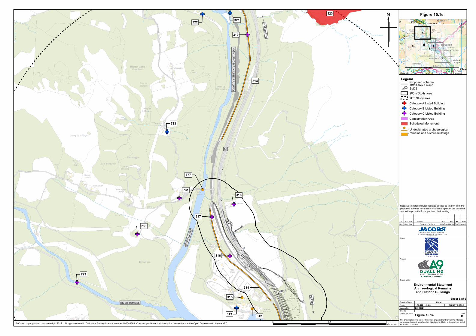
Figure 15.1e
?
N
Rev
Client
Project
Drawing title
Scale
Drawing number
Jacobs No.DO NOT SCALE@ A3
This drawing is not to be used in whole or part other than for the intendedpurpose and project as defined on this drawing. Refer to the contract for fullterms and conditions.
B2140004BIM No.
Rev. Rev. Date Purpose of revision Apprv'dRev'dCheckdOrig/Dwn
95 Bothwell Street, Glasgow, G2 7HX, UK.Tel: +44(0)141 243 8000 Fax:+44(0)141 226 3109
www.jacobs.com
Figure 15.1e
Environmental StatementArchaeological Remainsand Historic Buildings
0
JCrDEC 20170 ACES Publication
Drawing Status FINAL
MP AJG
Sheet 5 of 6
Legend
SuDS200m Study area2km Study area
GF Category A Listed BuildingGF Category B Listed BuildingGF Category C Listed Building
Conservation AreaScheduled Monument
}Undesignated archaeological remains and historic buildings
!(
0 0.5 1kilometres
1:10,000
Note: Designated cultural heritage assets up to 2km from theproposed scheme have been included as part of the baselinedue to the potential for impacts on their setting.
(DMRB Stage 3 design)Proposed scheme
ac
e
b
d f
!(
GF
GF
GF!(GF
GFGF!( GF
!(
GF
!(
GF
GF
GF GF
GFGF
GF
GFGF
GF
GFGFGF GF
GF GFGFGF GFGFGFGFGF
GFGFGFGFGF GFGFGFGF GF
GFGF GFGFGFGFGF GF
GFGFGFGF
GFGF GF
GFGF GFGFGFGFGF
GF
GF
GFGF
GF
GF
GF
GF
GFGF
PITLOCHRY
HIGHLAND MAIN LINE RAILWAY
INVERNESS
PERTH
LOCHFASKALLY
741
712711
709
708
707
706705 704
702
701
700699
698
697
696
695
694 693
692691 690
689
687686685
684
683
682
681
680
679 678
677
676675
674
673672
671670
669
667
666665
664
663662
661
660
659658
657
656
655
652
650649
648
647
646
645
292
688
© Crown copyright and database right 2017. All rights reserved. Ordnance Survey Licence number 100046668. Contains public sector information licensed under the Open Government Licence v3.0.
Figure 15.1f
?
N
Rev
Client
Project
Drawing title
Scale
Drawing number
Jacobs No.DO NOT SCALE@ A3
This drawing is not to be used in whole or part other than for the intendedpurpose and project as defined on this drawing. Refer to the contract for fullterms and conditions.
B2140004BIM No.
Rev. Rev. Date Purpose of revision Apprv'dRev'dCheckdOrig/Dwn
95 Bothwell Street, Glasgow, G2 7HX, UK.Tel: +44(0)141 243 8000 Fax:+44(0)141 226 3109
www.jacobs.com
Figure 15.1f
Environmental StatementArchaeological Remainsand Historic Buildings
0
JCrDEC 20170 ACES Publication
Drawing Status FINAL
MP AJG
Sheet 6 of 6
Legend
SuDS200m Study area2km Study area
GF Category A Listed BuildingGF Category B Listed BuildingGF Category C Listed Building
Conservation AreaScheduled Monument
}Undesignated archaeological remains and historic buildings
0 0.25 0.50.125 kilometres
1:3,750
Note: Designated cultural heritage assets up to 2km from theproposed scheme have been included as part of the baselinedue to the potential for impacts on their setting.
(DMRB Stage 3 design)Proposed scheme
!(


