Embed Size (px)
Citation preview

OF A A267 396
Th1w dcum~at ho been CLPPIOT4
DTIC1 ELECTE
S~A1 93-17157
Environmta -ImpactAnalsisProcess
I7

n,74:42' FP11,1 HID L"SýF fCEII TO O o:4:r PO
OF Air Force
Environmental Planning DiVisiono ~(HQ TJ /E VP)
V~RO~M SM69'~I~? ~/ 1260 Ak Fom; Pmaiagoi
e ~Wbashgicm DC 203301260
~ / 3Vfr sP
D2t4 227-292

COVER SHEET
a. Responsible Agency: U.S. Air Force
b. Action: In response to the recommendations of the Defense Secretary'sCommission on Base Realignment and Closure, the legislative requirements inthe Base Closure and Realignment Act (Public Law 100-526), and to U.S. AirForce plans to enhance mission readiness and national security, Beale Air ForceBase (AFB), located near Marysville, California, is planned to be realigned. The323rd Flying Training Wing now located at Mather AFB (located about 60 milesto the south) would be moved to Beale AFB. Construction of approximately 1.7million square feet of new facilities and demolition of several existing buildingswill be required.
c. Contact for Further Information: HQ SAC/DEVP, Offutt AFB, NE
402/294-3684
d. Designation: Draft Environmental Impact Statement (DEIS)
e. Abstract: This statement assesses the potential environmental impacts fromrealignment of Beale AFB, located near Marysville, California. Realignment willincrease on-base activity and require construction of new facilities. Existing airquality may be affected by both construction and operational activities.Operational impacts will not be significant with respect to local and regional airquality because operations will occur within the same air basin as they did atMather AFB. Biological habitats including vernal pools and other wetlands andriparian habitats may be affected by construction of new facilities; however, noFederal- or State-listed threatened or endangered species are expected to beaffected. Realignment will create additional peak period round trips, resultingin impacts on base access, intersections, and parking lots. Portions of the waterdistribution system and the water treatment facilities will have to be upgradedto meet the increased demand expected as a result of the realignment. If thepotential presence of abandoned underground storage tanks in areas planned forconstruction of new facilities and asbestos-containing materials in buildingsplanned for demolition or modification is verified, confirmatory studies andappropriate remedial actions will be required. The realignment will have apositive effect on the local and regional economy.
f. Comments on the Draft EIS should be addressed to HQ SAC/DEVP at theaddress noted above. The comment period ends on June 12, 1990. Notice ofa hearing on the Draft EIS will appear in local newspapers. HQ SAC/DEVP Lican also be contacted for information on this hearing
DTIC QUALITy PENLT•D i o. .
Availability Codes
- st ' Avail and/or
Dist J Special

TABLE OF CONTENTS
Sectionj~
LIST OF ACRONYMS .......................................... x
EXECUTIVE SUMMARY ..................................... ES-i
1.0 DESCRIPTION OF AND NEED FORTHE REALIGNMENT ACTION .............................. 1-1
1.1 INTRODUCTION .................................... 1-1
1.2 LOCATION OF BEALE AFB ........................... 1-2
1.3 SCOPING SUMMARY AND PREPLANNING
ANALYSIS ......................................... 1-2
1.4 RELEVANT FEDERAL, STATE, AND LOCALSTATUTES, REGULATIONS, AND GUIDELINES .......... 1-5
2.0 ALTERNATIVES INCLUDING THE REALIGNMENTACTION ................................................ 2-1
2.1 INTRODUCTION .................................... 2-1
2.2 DETAILED DESCRIPTION OF THEREALIGNMENT ACTION ............................. 2-1
2.2.1 Realignment Action ............................. 2-1
2.2.2 Construction and Facility Siting Alternatives ........... 2-5
2.2.3 Required Construction and Facilities ................. 2-7
2.2.3.1 Consolidated Aircraft Maintenance
Complex (CAMS) ........................ 2-7
2.2.3.2 Base Operating Support Complex (BOS)....... 2-16
2.2.3.3 Academic Complex ...................... 2-18
2.2.3.4 Family Housing ......................... 2-21
2.23.5 Demolition Candidates .................... 2-22
2.3 SUMMARY OF MAJOR ISSUES AND
POTENTIAL IMPACTS .............................. 2-22
3.0 AFFECTED ENVIRONMENT ................................ 3-1
3.1 INTRODUCTION .................................... 3-1
3.1.1 History ..................................... 3-1
3.1.2 M ission ...................................... 3-1
ii
i I II I I I II I I

TABLE OF CONTENTS (cont'd)
3.1.3 Existing Development ........................... 3-2
3.2 GEOLOGY, TOPOGRAPHY ........................... 3-2
3.2.1 Geologic Setting ............................... 3-2
3.2.2 Geomorphology ................................ 3-6
3.2.3 Seismic Activity ................................ 3-8
3.2.4 Soils ........................................ 3-8
3.3 AIR QUALITY ...................................... 3-9
3.3.1 Climate ...................................... 3-9
3.3.2 Air Resources ................................. 3-93.4 WATER RESOURCES ............................... 3-13
3.4.1 Groundwater ................................. 3-133.4.2 Surface W ater ................................ 3-13
3.4.3 W ater Quality ................................ 3-15
3.4.3.1 Groundwater ........................... 3-15
3.4.3.2 Surface Water .......................... 3-16
3.5 BIOLOGICAL RESOURCES .......................... 3-163.5.1 Vegetative Resources ........................... 3-16
3.5.1.1 General .............................. 3-16
3.5.1.2 Threatened, Endangered, and
Sensitive Species ........................ 3-17
3.5.2 Wildlife Resources ............................. 3-17
3.5.2.1 General .............................. 3-17
3.5.2.2 Threatened, Endangered, and Sensitive Species .. 3-20
3.6 ARCHAEOLOGICAL, CULTURAL, ANDHISTORICAL RESOURCES ........................... 3-20
3.7 NOISE ........................................... 3-21
3.7.1 Existing Noise Conditions ........................ 3-22
3.8 LAND USES ...................................... 3-24
3.8.1 Accident Potential ............................. 3-243.8.2 Height and Obstruction Criteria ................... 3-25
iii

TABLE OF CONTENTS (cont'd)
3.9 TRANSPORTATION .............................. 3-25
3.9.1 Access ...................................... 3-25
3.9.2 On-Base Roads ............................... 3-27
3.9.3 Bus Operations ............................... 3-27
3.9.4 Railroad .................................... 3-30
3.10 UTILITIES ........................................ 3-30
3.10.1 Electric Supply ............................... 3-30
3.10.2 Water Supply ................................. 3-30
3.10.3 Communication ............................... 3-32
3.11 WASTE MANAGEMENT ............................. 3-32
3.11.1 Solid Waste Disposal ........................... 3-32
3.11.2 Wastewater Disposal ........................... 3-33
3.11.3 Hazardous Waste Generation and Disposal ........... 3-33
3.11.4 Beale AFB Installation Restoration Program .......... 3-34
3.11.5 Underground Storage Tanks ...................... 3-34
3.11.6 Asbestos .................................... 3-41
3.12 SOCIOECONOMIC FACTORS ......................... 3-41
3.12.1 Demographics ................................ 3-41
3.12.2 Economic Characteristics ........................ 3-45
3.12-3 Housing .................................... 3-48
3.12.4 Education ................................... 3-49
3.12.5 Community Service Facilities ..................... 3-49
4.0 ENVIRONMENTAL CONSEQUENCES ......................... 4-1
4.1 MISSION AND OPERATION ........................... 4-1
4.2 GEOLOGY, TOPOGRAPHY ........................... 4-1
4.2.1 Cumulative Impacts ............................. 4-2
4.2.2 Mitigation Measures ............................ 4-2
4.3 AIR QUALITY ...................................... 4-3
4.3.1 Cumulative Impacts ............................. 4-7
4.3.2 Mitigation Measures ........................... 4-11
iv j

4.4 ATEIREOURCS I4-l
TABLE OF CONTENTS (cont'd)
4.4 WATER RESOURCES ............................... 4-12
4.4.1 Cumulative Impacts ............................ 4-12
4.4.2 Mitigation Measures ........................... 4-13
4.5 BIOLOGICAL RESOURCES .......................... 4-13
4.5.1 Cumulative Impacts ............................ 4-14
4.5.2 Mitigation Measures ........................... 4-144.6 ARCHAEOLOGICAL, CULTURAL, AND
HISTORICAL RESOURCES ........................... 4-15
4.6.1 Cumulative Impacts ............................ 4-16
4.6.2 Mitigation Measures ........................... 4-16
4.7 NOISE ........................................... 4-16
4.7.1 Cumulative Impacts ............................ 4-18
4.7.2 Mitigation Measures ........................... 4-18
4.8 LAND USES ...................................... 4-18
4.8.1 Cumulative Impacts ............................ 4-18
4.8.2 Mitigation Measures ........................... 4-18
4.9 TRANSPORTAI1ON ................................ 4-18
4.9.1 Cumulative Impacts ............................ 4-19
4.9.2 Mitigation Measures ........................... 4-19
4.10 TATE .........M............................. 4-22
4.10.1 Cumulative Impacts ............................ 4-22
4.10.2 Mitigation Measures ........................... 4-22
4.11 WASTE MANAGEMENT ............................. 4-23
4.11.1 Cumulative Impacts ............................ 4-24
4.11.2 Mitigation Measures ........................... 4-244.12 SOCIOECONOMICS, ................................. 4-25
4.12.1 Cumulative Impacts ............................ 4-29
4.12.2 Mitigation Measures ........................... 4-29
4.13 UNAVOIDABLE ADVERSE IMPACTS .................. 4-29
4.14 RELATIONSHIP BETWEEN SHORT-TERM
USES AND LONG-TERM PRODUCTIVITY .............. 4-29
V

TABLE OF CONTENTS (cont'd)
4.15 IRREVERSIBLE AND IRRETRIEVABLE
COMMITMENT OF RESOURCES ...................... 4-30
5.0 REFERENCES ........................................... 5-1
6.0 LIST OF PREPARERS AND ORGANIZATIONS ANDPERSONS CONTACTED ................................... 6-1
6.1 PREPARERS ....................................... 6-1
6.2 ORGANIZATIONS AND PERSONS CONTACTED .......... 6-2
APPENDIX A.- Average Daily Air Emissions Inventoryfor Yuba County .............................. A-1
APPENDIX B: Archaeological, Cultural, and Historic Resources ....... B-1
APPENDIX C: Noise Metrics ................................ C-1
vi m

LIST OF TABLES
No.Page
1-1 Summary of Relevant Federal, State, and LocalStatutes, Regulations, and Guidelines ......................... 1-6
2-1 Estimates of Full-Time Personnel Affected byRealignm ent ........................................... 2-2
2-2 Aircraft Operations and Expected Changes inOperations at Beale AFB ................................. 2-6
2-3 Programmed Project Cost and Budget Year .................... 2-8
2-4 Consolidated Aircraft Maintenance (CAMS) Complex ............ 2-15
2-5 Base Operating Support ................................. 2-17
2-6 Academic Complex ..................................... 2-19
2-7 Buildings Considered for Demolition ........................ 2-23
2-8 Major Potential Realignment Impacts on KeyAreas of Concern ...................................... 2-24
3-1 Units Assigned to Beale AFB as of 8 February 1990 .............. 3-3
3-2 Summary of Relevant Air Quality Data SurroundingBeale Air Force Base, 1985-1987 ........................... 3-11
3-3 Maximum Background Air Quality ConcentrationsSurrounding Beale Air Force Base, 1985-1987 .................. 3-12
3-4 Threatened, Endangered, and Sensitive Plant andWildlife Species That: May Occur iin the Vicinityof Beale AFB, California ................................. 3-18
3-5 Gate Traffic Volumes at Beale AFB ........................ 3-28
3-6 Utilization of Major Base Parking Lots ...................... 3-29
3-7 Annual Forecasted Quantities of WasteGenerated at Beale AFB ................................. 3-35
3-8 Beale AFB IRP Sites Summary ............................ 3-37
3-9 Summary of Asbestos Registry for BuildingsPlanned or Considered for Demolition or Modification ........... 3-42
3-10 Estimated Population of CommunitiesSurrounding Beale AFB ................................. 3-44
3-11 Annual Average Civilian Wage and SalaryEmployment, Yuba City Metropolitan StatisticalArea, 1987 (Yuba and Sutter Counties, CA) ................... 3-46
vii

LIST OF TABLES (cont'd)
No. -Page
3-12 Payroll and Expenditures and Estimated Impactsin 50-Mile Economic Impact Region in 1988 .................. 3-47
3-13 Beale AFB Students Enrolled in Yuba andSutter County Public Schools, FY 1989-90,by Assistance Category and School Capacity ................... 3-50
4-1 Maximum Daily Construction Emissions ....................... 4-4
4-2 Total Construction Emissions ............................... 4-5
4-3 Daily and Annual Aircraft Emissions FromSUNT Operations ....................................... 4-8
4-4 Daily Secondary Emissions From SUNT Operations .............. 4-9
4-5 Annual Secondary Emissions From SUNT Operations ............ 4-10
4-6 Impact on Peak Period Round Trips ........................ 4-20
A-1 1983 Base Year Inventory Average Daily Airt-missions, Yuba County ................................. A-2
B-1 Previously Recorded Archaeological Sites on BealeAir Force Base ........................................ B-3
B-2 Historical Locations on Beale Air Force Base .................. B-6
C-1 Loudness and Sound Levels of Everyday Noise ................. C-3
viii

!IST OF FIGURES
1-1 General Location M ap ................................... 1-3
2-1 "oillprehensive Plan, Beale Air Force Base ................... 2-10
2-2 Comprehensive Plan, Beale Air Force Base ................... 2-11
2-3 Comprehensive Plan, Beale Air Force Base ................... 2-12
2-4 Comprehensive Plan, Beale Air Force Base ................... 2-13
3-1 Functional Areas ........................................ 3-4
3-2 Geographic Setting ...................................... 3-5
3-3 Schematic of Geomorphic Units at Beale Air Force Base .......... 3-7
3-4 Major Surface Water Drainage Systems ...................... 3-14
3-5 Noise Contours (L.) .................................... 3-23
3-6 Base Access .......................................... 3-26
3-7 W ater Distribution System ................................ 3-31
3-8 IRP Site Locations ..................................... 3-36
4-1 Noise Contours (.,,,) for Operations ........................ 4-17
B-1 Predicted Zones of Prehistoric Resource Occurrence ............. B-2
C-1 Examples of Average Day-Night Sound Levels, I., ............... C-6
ix
LIP

LIST OF ABBREVIATIONS AND ACRONYMS
AAFES Army Air Force Exchange Service
ABC Air Base Group
ACHP Advisory Council on Historic Preservation
AFB Air Force Base
AFR Air Force Regulation
AICUZ Air Installation Compatible Use Zone
APZ Accident Potential Zone
ATC Air Training Command
BACT Best Available Control Technology
BAFB Beale Air Force Base
BASH Bird Air Strike Hazard
BEA Bureau of Economic Analysis
BIDDS Base Information Digital Disiribution System
BOS Base Operating Support
CAAQS California Ambient Air Quality Standards
Cal EDD California Employment Development Department
Cal DOF California Department of Finance
CAMS Consolidated Aircraft Maintenance Complex
CARB California Air Resources Board
CBPO Consolidated Base Personnel Office
CCSCE Center For Continuing Study of the California Economy
CDFG California Department of Fish and Game
CEO Council of Environmental Quality
CERCLA Comprehensive Environmental Response Compensation and LiabilityAct
CFR Code of Federal Regulations
CLUP Comprehensive Land Use Plan
CO Carbon Monoxide
COE U.S. Army Corps of Engineers
COMBS Contractor Operated/Managed Base Supply jCRWOCB California Regional Water Quality Control Board
XII1
I
LIST OF ABBREVIATIONS AND ACRONYMS (cont'd)
cy Cubic Yard
CZ Clear Zone
dB Decibel
DOD Department of Defense
EA Environmental Assessment
EIFS Economic Impact Forecast System
EIR Economic Impact Region
EIS Environmental Impact Statement
EO Executive Order
EPA Environmental Protection Agency
ERIS Economic Resource Impact Statement
EWO Electronics Weapons Officer
FAA Federal Aviation Administration
FTW Flying Training Wing
FY Fiscal Year
gpm Gallons per minute
HQ SAC Headquarters Strategic Air Command
HUD U.S. Department of Housing and Urban Development
IRP Ins'allation Restoration Program
kV Kilovolts
11. Average Day-Night Sound Level
MES Management Engineering Squadron
MET Management Engineering Team
mg/l Milligrams per Liter
mgd Million Gallons Per Day
MOA Military Operating Areas
MSA Metropolitan Statistical Area
MUTCD Manual On Uniform Traffic Control Devices
NAAQS National Ambient Air Quality Standards
NCO Non-Commissioned Officer
NEPA National Environmental Policy Act of 1969
xi

LIST OF ABBREVIATIONS AND ACRONYMS (cont'd)
NO2 Nitrogen Dioxide
NOI Notice of Intent
NO. Oxides Of Nitrogen
NPDES National Pollution Discharge Elimination System
NZ Noise Zones
03 Ozone
PAT Planning Assistance Team
PAVE PAWS Precision Acquisition Vehicle Entry Phased Array Warning System
PCB Polychlorinated Biphenyls
PMKo 10-Micron Particulate Matter or Less
SAC Strategic Air Command
SACOG Sacramento Area Council of Governments
SARA Superfund Amendments and Reauthorization Act
SCS Soil Conservation Service
SEL Sound Exposure Level
SHPO State Historic Preservation Officer
SID Standard Instrument Departures
SO2 Sulfur Dioxide
SRW Strategic Reconnaissance Wing
STP Sewage Treatment Plant
SV Services Squadron
SUNT Specialized Undergraduate Navigation Training
TCE Trichloroethylene
TDS Total Dissolved Soils
ug/mf Micrograms per Cubic Meter
USAF United States Air Force
USDA United States Department of Agriculture
UST Underground Storage Tank
xii

EXECUTIVE SUMMARY
The action evaluated in this Environmental Impact Statement (EIS) is therealignment of Beale Air Force Base (AFB), California. The realignment is the resultof the recommendations of the Defense Secretary's Commission on Base Realignmentand Closure, legislative requirements in the Base Closure and Realignment Act, andU.S. Air Force (USAF) plans to enhance mission readiness and national security. Therealignment involves the relocation of the 323rd Flying Training Wing--the SpecializedUndergraduate Navigation Training (SUNT)--currently operating out of Mather AFBnear Sacramento, California, to nearby Beale AFB. The SUNT includes 14 T-43 and25 T-37 aircraft, 486 military personnel, 307 full-time civilians, and a daily average of773 students. Additionally, a few tenant organizations with small numbers of personnelcurrently located at Mather AFB will relocate to Beale AFB as part of the realignment.
The Commission determined that this realignment will be facilitated by anunrelated and previously programmed force structure action to deactivate the SR-71program at Beale AFB. The deactivation of the SR-71 program has been the subjectof a separate National Environmental Policy Act (NEPA) document; however, thecumulative assessment of the force structure change is addressed in this EIS.
Beale AFB will experience construction of approximately 1.7 million squarefeet of floor area in various types of new facilities over the next 3 years toaccommodate the realignment. In addition, several existing buildings will bedemolished and/or renovated. Right operations at Beale AFB will increase byapproximately 34 percent as the 323rd Flying Training Wing (FTW) activity is addedto existing operations.
Provisions of the Base Closure and Realignment Act preclude the examinationof any alternative actions to realignment, but allow for the examination of alternativemethods of implementing the realignment. Because the act requires implementationof the realignment to occur at Beale AFB, the "no action" alternative, as well as thealternative to relocate the SUNT to a base other than Beale AFB, has not beenevaluated.
The following areas of environmental concern were identified during the scopingprocess: geology and topography; air quality; water resources; biological resources;archaeology; noise; land use; transportation; utilities; waste management; andsocioeconomics. For these areas of concern, potential environmental consequencesassociated with realignment are described and, as applicable, mitigation measures arerecommended.
Geology and To'ography. Potential geologic and topographic impacts could includeearthquake-induced strong groundmotion, liquefaction, settlement or expansion ofsoils, erosion, and construction-induced terrain modification. Potential mitigationmeasures to reduce impacts to insignificant levels include the design and constructionof facilities to withstand strong groundmotion and site-specific geotechnicalinvestigations. Measures proposed include dissipation and direction of runoff,
r

S- T -!
I III
IH
soils, erosion, and construction-induced terrain modification. Potential mitigationmeasures to reduce impacts to insignificant levels include the design and constructionof facilities to withstand strong groundmotion and site-specific geotechnicalinvestigations. Measures proposed include dissipation and direction of runoff,revegetation of disturbed areas, limitation of grading activities, and balancing of cutand fill volumes.
Air aiy. Existing air quality may be affected by both construction and operationalactivities. Construction impacts are anticipated to be short-term and localized,whereas operational activities will be long-term. Construction emissions will primarilybe associated with exhaust and dust generated by heavy equipment. These short-term impacts will be minimized by the proposed suppressing of dust during high windconditions. Additionally, potential measures including minimizing overlap of activitiesand subsequent overlap in peak short-term emissions; installation of vapor recoverysystems on gasoline-powered construction equipment; curtailment of activity duringperiods of high ozone conditions; paving high-use haul routes; and covering stockpilesmay be taken.
Operation emissions will be generated from aircraft emissions; aircraft refueling;aircraft maintenance; motor vehicles; building maintenance; and automotive refueling.However, it is anticipated that impacts resulting from SUNT operations will not besignificant with respect to regional air quality, because SUNT operations will occurwithin the same air basin as they did at Mather AFB; therefore, they do not representa new source of air emissions into the air basin. Local air quality at Beale AFB willbe impacted by increased emissions. Potential mitigation measures to reduceoperational air emissions include encouragement of car and van pooling and bustransportation, and use of state-of-the-art natural gas boilers at new facilities.
Water Resources. Surface water quality on base is not anticipated to be adverselyaffected by the realignment. Likewise, increased water demand as a result of therealignment is not expected to significantly affect existing water table levels, alter thedirection of groundwater flow, or affect other groundwater users in the area. Floodingand/or erosion impacts could occur, although their potential is considered very low.To reduce the potential for flooding and erosion impacts, it is proposed that sitegrading activities be minimized during the rainy months and that all site preparationactivities incorporate best available storm water management practices.
Biological RW iourej Although the realignment will primarily disturb introducedannual grassland, other habitats, including vernal pools and other wetlands andriparian habitats, may be affected. Consultation with the U.S. Army Corps ofEngineers (COE) will be undertaken in regards to their wetlands permit authority.Proposed mitigation measures to lessen potential impacts will include minimizing theareas to be graded; exclusion of construction-related activity from sensitive wetlandand riparian habitat areas; protection of wetlands with silt curtain/fence material;landscaping to reestablish vegetation in disturbed areas with use of native species; and
ES-2

Preservation Officer (SHPO) and the Advisory Council on Historic Preservation(ACHP).
Noise. Noise levels will increase very slightly over existing levels after the SUNTbegins operating at Beale AFB. An increase of approximately 2 percent in land area(750 acres) exposed to noise levels in excess of an average day-night sound level (L,)of 65 is projected. It is proposed that night flight activity be minimized to the extentpractical.
Land Uses. Existing land uses in the vicinity of Beale AFB will not be significantlyimpacted by the realignment. Although an approximate 750-acre expansion of the 65L, contour is projected to occur as a result of additional flight activity, this additionalacreage predominantly consists of agricultural uses. As a result, no mitigation measuresare proposed.
Transportation. The realignment will create additional peak period round trips to andfrom the base, resulting in impacts on base access, intersections, and parking lots. Anadditional 671 additional trips are expected during weekday peak periods. A numberof specific improvements to the on-base road system, parking lots, and gates, as wellas encouragement of alternatives to single-occupant automobile trips, are potentialmeasures to mitigate impacts to transportation.
Utilities. Increases in electricity and water demand, and communication needs willoccur as a result of the addition of the SUNT to Beale AFB. However, the increasein electricity demand is not expected to present a significant impact because there areample power supply and distribution systems on base. Water capacity on base isadequate to meet projected demands associated with increased base personnel.However, portions of the water distribution system will have to be upgraded in orderto adequately provide water to one portion of the base. In addition, existing watertreatment will have to be upgraded to mitigate high mineral levels during periods ofpeak demand. Impacts to water distribution are proposed to be mitigated by replacinga deteriorating 18-inch supply line from the on-base well field with a new, larger 20-inch line and by installing a second supply line to the flightline area and additionalpumps to the housing area. A potential mitigation measure for the treatment systemis the addition of facilities to reduce high mineral levels. No impact to on-basecommunication systems is anticipated.
Waste Management, Waste management issues were evaluated regarding potentialimpacts to solid waste disposal, wastewater disposal, hazardous waste generation anddisposal, underground storage tanks (USTs), and asbestos. Solid waste and wastewaterdisposal are not anticipated to present significant impacts to existing landfill andsewage treatment facilities. Potentially, the wastewater system may be improved byadditional backup lift pumps at one location and by using a storm water managementprogram. Hazardous waste generation will be limited to small amounts associated withthe operation and maintenance of SUNT aircraft and are not anticipated to presentsignificant impacts related to storage and disposal. Several abandoned USTs may existin areas where SUNT facilities will be built. Portions of these areas have beensurveyed to determine potential UST locations; however, results have not beenconfirmed by excavation. In areas where the potential for USTs exist, it is proposed
E-S-3

that additional geophysical surveys and excavations be conducted to confirm theirpresence and location. Several of the buildings slated for demolition ormodification may contain asbestos in various forms. To confirm the presence ofasbestos, it is proposed that detailed surveys be conducted prior to demolition ormodification, If asbestos is confirmed, appropriate remedial actions will beimplemented.
Socioeconomics, The realignment of Beale AFB will bring additional people andrevenue to the region around the base. The local economy will receive most of theestimated $72 million per year in increased base operating expenditures. The regionalimpact of this spending is projected to be about $97 million per year. Of this, about$48 million per year would accrue to regional households as personal income. Localgovernment revenues and expenditures are also projected to increase. These beneficialeconomic impacts are small in the regional context.
The number of personnel and their dependents moving to Beale AFB isexpected to be 3,435. Induced population growth would bring the total addition tolocal population to 4,100 persons. Construction activity will create short-termemployment for up to 800 workers, and indirect regional employment--attributable toconstruction of realignment facilities--will amount to about 3,465 person-years duringFY 91 through FY 93. Long-term employment gains supported by realignment willaverage 2,200 jobs. These population and employment impacts do not significantlyaffect current regional trends and are generally beneficial.
The 829 permanent party personnel are expected to relocate to the area aroundBeale AFB. An adequate housing supply exists to accommodate these households.Additionally, 450 to 475 school-age children of SUNT personnel are expected to enterarea schools after the realignment. Nearly all of these children are expected to attendWheatland schools, which currently have substantial excess capacity. Education impactassistance to schools is projected to increase by between $652,600 and $688,850 peryear. The sufficient capacity and additional impact assistance renders the impact of therealignment on schools insignificant. Impacts to other types of community services arenot expected to be significant.
ES-4

1.0 DESCRIPTION OF AND NEED FOR THE REALIGNMEN" ACTION
1.1 INTRODUCTION
The Defense Secretary's Commission on Base Realignment and Closure(Commission) was chartered on May 3, 1988, by the Secretary of Defense torecommend realignment and closure of military installations within the United States,its commonwealths, territories, and possessions. Subsequently, the Base Closure andRealignment Act (Public Law 100-526, October 24, 1988) endorsed the Secretary'sCommission and required the Secretary of Defense to implement its recommendationsunless he rejected them in their entirety or the Congress passed (and the Presidentsigned) a Joint Resolution disapproving the Commission's recommendations.
The primary criterion used by the Commission for identifying candidate baseswas the military value of the installation. However, cost savings were also considered,as were the current and projected plans and requirements for each military service.Last, the Commission focused its review on military properties and their uses, notmilitary units or organizational/administrative issues.
On December 29, 1988, the Commission recommended the realignment andclosure of 145 military installations. Of this number, 86 are to be completely closed,5 are to be closed in part, and 54 will experience a change (either an increase ordecrease in units and activities) as units and activities are relocated.
On January 8, 1989, the Secretary of Defense approved those recommendationsand announced that the Department of Defense (DOD) would implement them. TheCongress did not pass a Joint Resolution disapproving the recommendations within thetime allotted by the Base Closure and Realignment Act.
Therefore, the Act now requires the Secretary of Defense, as a matter of law,to implement those closures and realignments. Implementation must be initiated bySeptember 30, 1991, and must be completed no later than September 30, 1995. Thus,the decision has been made to realign Beale Air Force Base (AFB), California.
The realignment involves the relocation of the 323rd Hying Training Wing(FTW)-the Specialized Undergraduate Navigation Training (SUNT)--currentlyoperating out of Mather AFB near Sacramento, California, to nearby Beale AFB.The SUNT includes 14 T-43 and 25 T-37 aircraft, 486 military personnel, and 307full-time civilians. Approximately 1,100 students enter SUNT each year withapproximately 950 graduating annually. An average of 773 students are involved withSUNT-related activities on a daily basis. The withdrawal of the SUNT and the closureof Mather AFB is the subject of a separate National Environmental Policy Act of 1969(NEPA) document.
It was determined by the Commission that this realignment will take advantageof an unrelated and previously programmed force structure action to deactivate theSR-71 program at Beale AFB and improve multiservice training by using existingfacilities at Beale and consolidating similar activities. The unrelated and previously
1-1
planned deactivation of the SR-71 program has been the subject of a separate NEPAdocument; however, the cumulative assessment of the force structure change isaddressed in this Environmental Impact Statement (EIS).
The Base Closure and Realignment Act requires the implementing actions toconform to the provisions of NEPA, as implemented by the President's Council onEnvironmental Quality (CEQ) regulations (40 CFR 1500-1508). In addition, this EISalso follows Air Force regulations (AFR) 19-2, which incorporate both NEPA and theCEQ regulations within the Air Force system. However, the Base Closure andRealignment Act also modifies NEPA to the extent that the environmental analysisneed not consider:
"* The need for closing or realigning a military installation selected forclosure or realignment by the Commission.
"* The need for transferring functions to another military installation thathas been selected as the receiving installation.
"* Alternative military installations to those selected.
1.2 LOCATION OF BEALE AFB
Beale AFB currently consists of 22,944 acres of government-owned land inYuba County, approximately 40 miles north of the city of Sacramento and 13 mileseast of Marysville, in north-central California (Figure 1-1). The foothills of the SierraNevada mountains border the eastern edge of the base. Large water sources thatborder the base include the Yuba River to the north, the Bear River to the south, andCamp Far West Reservoir to the southeast. Other neighboring cities are Yuba City,16 miles west; Oroville, 40 miles north; and Grass Valley, 25 miles east.
1.3 SCOPING SUMMARY AND PREPLANNING ANALYSIS
The United States Air Force (USAF) published a Notice of Intent (NOI) inthe Federal Register on February 8, 1989, to prepare an EIS for the realignment ofBeale AFB. In accordance with the information presented in the NOI, the USAFheld a public scoping meeting on February 15, 1989, at the Marysville Chamber ofCommerce building. The purpose of this public meeting was to obtain input from thegeneral public and Federal, State, and local agency personnel to assist the USAF indetermining the nature, extent, and scope of significant issues related to therealignment action.
The public scoping meeting was attended by approximately 34 persons, includingvarious military personnel, the local news media (four local television stations, a localradio station, and a local newspaper), and a few local citizens. No written or oralcomments or concerns were presented by anyone in attendance. However, the generalpublic and agency officials were allowed until March 15, 1989, as stated in the NOI,to submit written comments on issues to be addressed in the EIS.
1-2

or
BesleAFS
CALIFORNIA W
ovL"Nos"it
*0AD
L"A
NEALE COLIAlItEs
G mrXursym 5 MILES
SCALE
Sou"*: SACOG, 1987
-WARYSWLLt
rjSEAW
YUBA AIR FORCIE VIAKcouNryA14PORr
pm
um
40"
FIGURE 1 -1GENERAL LOCATION MAP

The USAF received four letters from various State and Federal agenciesexpressing issues and concerns about the realignment action. Based on theinformation presented in these letters, significant issues that relate to the realignmentaction include the following:
"* Potential impacts to wetland and vernal pool areas.
"* Increased demand on existing wastewater treatment plant capacities.
"* Potential impact to known areas of past contamination on base and tocurrent or increased hazardous waste generation, use, and disposalmanagement.
"* Potential impacts to air quality.
"* Potential increases ir noise.
"* Potential impacts to surface water quality.
Potential impacts to protected plant and/or animal species.
"* Potential impacts to migratory deer herds.
"* Potential impacts to salmon spawning areas in Dry Creek/Best Slough.
It should be noted that, at the time the scoping process was being conducted,the USAF was proposing that a new parallel runway adjacent to the existing runwayat Beale AFB be constructed as part of the realignment action. Subsec!aent to thepublic scoping process, the Air Force Council disapproved the construction of thissecond runway. Therefore, Federal and State agency concerns expressed in theirletters that address potential impacts related to construction of an additional runwayas part of the realignment action are no longer relevant. However, a Parasail areafor parachute training, consisting of a 3,000 foot diameter circular road crossed byseveral paved intersecting roadways has has been added to the realignment actionsince the completion of the scoping process. Concerns related to the additionalrunway pertaining to potential impacts on biological resources are generaily applicableto this training facility.
The results of the scoping process have identified several issues to be addressedas part of the environmental impact analysis. In addition to those issues ider..ified byState and Federal agencies, the following issues will be addressed in this EIS: geologicenvironment; water supply;, zoning and political boundaries; archaeological, cultural,and historic resources; transportation; utilities and waste management; andsocioeconomic issues including employment, household income, housing, education, andcommunity service facilities.
1-4

1.4 RELEVANT FEDERAL STATE. AND LOCAL STATUTES. REGULATIONS.AND GUIDELINES
A summary of governmental actions including laws, regulations, executive orders(EO), and other types of actions imposing requirements relevant to the SUNTrealignment action is presented in Table 1-1.
1-5

tnd
0 M 4)
06- 0G toCS ) VCUQ 0 -' t--)~ 4)t- =
0 > O4
L ~ 0 U t -n. C) 4 L.>~ 0 0 0 c
~u c
G, W , L
U) V o-4) 06 =0,0 C4
(6o40m I
0 6 V(4 m06
b.. Ce
v) - v0U
-,. 0 ; o.
- C: C6D ->)s0 0 U0 " ý
0m-
0,
z0 -0
"o Do-~
*E(4L 4 o
u 730o
U Ui
0
0 S
~1 1-6
4) toC
v) 00 -
cn )~ to 0 cn .0 -
Q6.0 M o
-) ' - 0 r ,
0 b.D o ~ V
eVd 0 -0 4- = . -
to Co t
to O0 V -
0U 0 1
b. * I- wgo -W a 40C0 V0I
6m 0-. 6.
W.--
= 0.
aa. 0 03
cc -U
00U.
u 4?
00
< 4
v-
= r0 a aU, g
c 0600Zcy
4) U) U) CU U c
'-~ .0 0~,C L U C f- a o0;
to cl 0 -- h
0) 0 c- U)*
'V~oo
~t 060I.
0 .l - 6
0
z1. 06' LL0 S0
ICWC
ONU
sgo
oo -;c
* 1-8
-0 0 . 0 06u0
V2 V00 4)04 o~ C-
06 W u~u0 a 'I 4
I.. - C6.0 bg% A. U r-
1 0 0'- ,O C: 00 4 0-E 4)4 - >
6. 0- E mcc _o Cc
Do gn -. 4=
I- W .- 4 ) . u -3 0 . .a
*0 C)
2 -. 0. : - V m c0 0 .
cc m= 0 v cts r WC..x0 66
'Co too 0 S
000 Cu >,00. .
I-
o -6 TOtoCoCCc ' .5:= v - ' &.-0 Z E 6 U
0 t;0 CLcd =M 0lu C6 E
.0
C:C
0 CU'0 *Z
w .u'e q
*. 5..
Z0
%6 U
____ _ __1-9

0 .0U3 ~ ~En C0 Z CV . EnE
06 0 c
0. 0--- E .c4)-E to z nC C n4
to U S~ o 0cI : 0-w
X.0 0 u0 a: I- c c o C: -.vuo ~ ~ ~ ~ & 4a0 0~ 0 E) ) UO ~ Q
as 4 Enco gn 0Z~~ 4) z -0
= 0.- - 0 -
00 0 :Q.Coo
NS 06 V. U.
cca 0 0 0i0 0 -u >
-a 01" ) = ý,co -.0 '.*=U
o 06ZC*0
En in= 00C .t ;0z U
00
w P1
'E U.
rigo
I 1-10

.00
U = . ' iý 0 174) S Q. Cc .0 oo - 4
ccV - . r_ %.0U
0'0= >
- InC
0 000 00
r- W% WN
= C4cc *2. Oh.
c 75 0
C 6
4D)
= W-uu u U
VV0cgcc
00
Go
22

2.0 ALTERNATIVES INCLUDING THE REALIGNMENT ACTION
2.1 INTRODUCTION
The Base Closure and Realignment Act (Public Law 100-526, 24 October 1988)requires the Secretary of Defense, as a matter of law, to implement the realignmentof Beale AFB to include the SUNT mission. The Act requires the implementingactions to conform to the provisions of NEPA. However, the Act also precludes theexamination of any alternative actions to realignment. Consequently, this documentwill only examine alternate methods of carrying out the realignment. Because the Actrequires implementation of the realignment, "no action" is not an alternative and is notspecifically included. However, Chapter 3 presents the environmental conditionsassociated with the installation and its operations, which will serve as the baselineagainst which the implementation impacts are judged.
2.2 DETAILED DESCRIPTION OF THE REALIGNMENT ACTION
2.2.1 Realignment Action
The realignment action involves the addition of the SUNT, currently locatedat Mather AFB, to Beale AFB. The SUNT consists of six navigator training squadronsand one aircraft maintenance squadron. Approximately 1,100 students (Air Force,Navy, Marine, and foreign national) enter SUNT each year with approximately 950graduating annually. The average daily student load is approximately 773 persons. Inaddition to these students, there are also 486 full-time military personnel and 307full-time civilians associated with SUNT operations, including administrative staff,faculty, aircraft operations and maintenance personnel, and staff of tenant units.Estimates of the numbers of full-time personnel expected to relocate to Beale AFB asa result of the realignment are presented in Table 2-1. In addition to the SUNTpersonnel, 33 military personnel and 3 civilians under various commands are expectedto relocate. No reserve personnel will be affected by the realignment.
Since the Strategic Air Command (SAC) is the host command at Beale AFB,Base Operating Support (BOS) personnel included in the realignment will bereassigned from the Air Training Command (ATC) to SAC. It is estimated thatapproximately 230 positions of the 829 permanent party expected to relocate will bereassigned, including approximately 90 medical personnel. These 230 positions areexpected to bring support units up to required strength to accommodate the additionof the SUNT.
SUNT operations at Beale AFB are expected to become fully operational bythe fourth quarter of fiscal year (FY) 1993. Once operational, a complete SUNT in-session training course would last approximately 170 work days per year. Although thisrepresents a 34-week (or an approximate 9-month) period, in-session training coursesare continuously scheduled throughout the calendar year; thus, SUNT activities wouldoccur at Beale AFB year round.
2-1

TABLE 2-1
Estimates of Full-Time Personnel Affected by Realignment
Unit Officers Enlisted Civilians Total
323rd FTW (includes the 324 31 6 361450th, 451st, 452nd, 453rd,454th, and 455th FlyingSquadrons)
Department Operations Staff 49 26 56 131
Wing Headquarters 5 8 7 20
Physiological Training Unit 4 22 0 26
3314th Management 1 4 0 5Engineering Squadron (MES)Headquarters
Wing Commander 7 5 3 15
Aircraft Maintenance, __ 235Contractor
TOTAL, SUNT personnel 390 96 307 793
Tenant Units' -12 21 _3 36
TOTAL, Permanent Party 402 117 310 829
Students (average daily load) 72 51C A 773
TOTAL, Realignment 1,125 167 310 1,602
Source: 323rd FTW, ABG, Mather AFB; February 1990.Notes: 'Tenants include Air Force Communications Command, Air Force Commissary
Service, Office of Special Investigations, Military Airlift Command, Air ForceLegal Services Center, Air Force Audit Agency, Military Personnel Center,Air Force Logistics Command, and Electronics Security Command.
'Approximately 50 Marine students are considered enlisted. All other studentsare officers.
2-2
Flying operations related to SUNT would use Beale AFB for runway, hangar,maintenance, and repair facilities. However, air space necessary for flight trainingexercises would occupy essentially the same air space these exercises currently occupyoperating out of Mather AFB. The T-43 aircraft will continue to use the establishedlow-level training routes--designated IR-207, IR-275, and IR-400. The T-37 aircraft willbe assigned new Standard Instrument Departures (SIDs) by the Federal AviationAdministration (FAA). SIDs provide standard routes for the transition of an operationbetween departure and the enroute phase. Military Operating Areas (MOAs), specificairspace units designated for military training operations, used by the T-37 will not bechanged (Personal Communication, HQ SAC, February 1990).
Current flying operations at Mather AFB for the T-43 average 2,673 sortiesannually. Operations for the T-37 at Mather AFB average 8,262 sorties annually.These two types of aircraft average 82,800 runway operations each year--20,206 forthe T-43 and 62,604 for the T-37. An operation consists of one takeoff, one landing,one low approach, or one tor-ch and go, while a sortie is a complete mission flown byone aircraft that may include a number of operations. For these two types of aircraft,as they are currently operating at Mather AFB, there is an average of 7.5 operationsduring each sortie (Personal Communication, Captain Byron Wall, Mather AFB,February 1990).
The T-37 aircraft operated by the SUNT program is a two-seat jet trainerdesigned as such for the Air Force. Manufactured by Cessna, the T-37 has a wingspan of over 33 feet, a length of approximately 29 feet, and an overall height ofapproximately 9 feet. The maximum level speed of a T-37 is 370 knots or 426 milesper hour (mph) and its maximum range is 819 nautical miles or 943 miles. Productionof the T-37 ceased in 1977 (Jane's, 1977-78).
The SUNT also operates T-43 aircraft that were manufactured by Boeing astheir model number 737-200. These craft, designed as commercial transports, weremodified for the Air Force as navigator trainers. Each craft accommodates up to 12student navigators, four navigator proficiency students, and three instructors. Thesecraft have a wing span of 93 feet, a length of 100 feet, and an overall height of 37 feet.The maximum level speed of the T-43 is 509 knots or 586 mph and its maximum rangeis 2,200 nautical miles or 2,530 miles. Boeing ceased production of the 737-200 in1988 (Jane's, 1979-80 and 1989-90).
A force structure action was programmed at Beale AFB prior to the realignmentaction. This action was the deactivation of SR-71 flying operations and related supportfunctions, which affected 586 military personnel and 38 civilian personnel (HQ SAC,January 1990).
The realignment action and the force structure change will result in changes inthe units operating at Beale AFB. The existing units, as of February 8, 1990, arepresented below. Units associated with the realignment are presented in Table 3-1.
The 14th Air Division includes:
2-3
The 9th Strategic Reconnaissance Wing (SRW) includes:The 5th Strategic Reconnaissance Training Squadron.The 99th Strategic Reconnaissance Squadron.The 349th Air Refueling Squadron.The 350th Air Refueling Squadron.The 9th Avionics Maintenance Squadron.The 9th Field Maintenance Squadron.The 9th Organizational Maintenance Squadron.The 609th Organizational Maintenance Squadron.The 9th Reconnaissance Technical Squadron.
The 814th Combat Support Group includes:The 814th Civil Engineering Squadron.The 814th Security Policy Squadron.The 814 Services Squadron.The 814th Mission Support Squadron.
"* The 814th Supply Squadron.
"* The 814th Transportation Squadron.
"* The 814th Comptroller Squadron.
Units that are not part of the 14th Air Division include:
"* The 814th Strategic Hospital.
"* Detachment 6 of the 3904th Management Engineering Squadron, SAC.
"* The 7th Missile Warning Squadron, tenant.
"* The 1360th Audiovisual Squadron, tenant.
"• Detachment 626 of the 3753rd Field Training Squadron, tenant.
"* Detachment 11 of the 9th Weather Squadron, tenant.
"* The 1883rd Communication Squadron, tenant.
"• The Air Force Commissary Service, tenant.
"• The Air Force Legal Services, tenant.
"• The Air Force Office of Special Investigations, tenant.
(Source: Captain Mark Plaster, Beale AFB, Det 6, 3904 MES/SAC MET).
The deactivation of the SR-71 program will begin with the loss of one unit fromBeale--the 1st Strategic Reconnaissance Squadron. This squadron includes 30 officers,
2-4
nine enlisted personnel, and one civilian. Other units of the 9th StrategicReconnaissance Wing associated with the SR-71 program will also experience personnelreductions. This deactivation has been addressed in a separate EnvironmentalAssessment (EA) (HQ SAC, January 1990).
Changes in flight operations are expected as a result of both the force structure
change and the realignment. Table 2-2 presents estimates of average daily operationsand projected maximum changes. The projected maximum cumulative averageoperations per day include an undetermined classified number of T-38 and KC-135aircraft associated with the deactivation of the SR-71 program.
2.2.2 Construction and Facility Siting Alternatives
Construction of new facilities and upgrading of existing facilities will be requiredto provide adequate support to implement the realignment action. Based on theconstruction schedule and operational requirements, Beale AFB will be ready to beginaccepting the SUNT in FY 93. All realignment actions are expected to be completedby the end of FY 93.
Planning assistance for the siting of new facilities required as a result of therelocation of the SUNT to Beale AFB was requested by HQ SAC. In response, aPlanning Assistance Team (PAT) was organized and managed by the office of the AirForce Regional Civil Engineer, Western Region. The PAT consisted of membersrepresenting the following disciplines: airfield planning, aircraft maintenance,architecture, community and environmental planning, and engineering.
The PAT focused attention primarily on facilities identified and required bySAC and ATC. Professional engineering and community planning judgment, guidanceand standards established by Air Force directives, expressed local interests, andfunctional relationships were used to recommend siting for functional complexes andindividual facilities. Factors for siting facilities considered by the PAT included thegeneral and specific guidance set forth in AFR 86-4, Base Comprehensive Planning,and other associated directives; the airfield and airspace criteria contained inAFR 86-14; contaminated areas being investigated or remediated in accordance withthe Air Force Installation Restoration Program (IRP); quantity-distance zones aroundexplosives storage sites; AICUZ noise zones; an evaluation of existing facilities in thedevelopment zones for contribution to or impact on the new functional use of the area,and conversion or removal if required; existing and projected traffic patterns andvolumes; operational requirements expressed by ',ie senior staffs at Beale AFB andMather AFB; and functional relationships.
Complexes, or groups of facilities, were established based on functionalrelationships between facilities with existing compatible functions and land use zonesso that similar functions would be consolidated. Spatial requirements, physicallimitations, and environmental concerns were also major considerations. As a result,three complexes were developed-the academic complex, the consolidated aircraftmaintenance complex, and the base operating support complex. The base traffic
2-5

.0
E cQ=0 0
w C4
t-o
6.
o4a4 0
-~ 00 00
a.;w C4,C6- go
ca Vfa~
UU
&0 es '
04-
V-2->

network and existing facilities that would be consolidated, displaced, and/or relocatedto other sites were also evaluated.
Adjustments and refinements to the recommended PAT sitings were made bythe base and both Commands to take advantage of consolidation savings and joint useof facilities. The goal was to build the most efficient and cost-effective operation.
The required construction activities are shown in Table 2-3. The programmedcost of each construction project and the budget year in which funding will be providedare also shown in this table. Figures 2-1 through 2-4 show the preferred or selectedlocations of the facilities; the facilities are referred to on the figures as indicated inthe reference key column in Tables 2-4 through 2-6. Table 2-7 presents informationabout buildings that may be demolished to allow construction of new facilities. Thesebuildings are also shown on Figures 2-1 through 2-4 using the reference key indicatedon this table. The alternative sites considered for required complexes are shown onFigure 2-5.
2.2.3 Required Construction and Facilities
Principle components of the realignment action will require construction of newfacilities and modifications to existing facilities. Construction will range from FY 90through FY 93, with the SUNT fully operational at Beale by the fourth quarter of FY93. The general purpose of each complex or grouping of facilities, with specificconcerns and alternatives for siting of these facilities, follows.
2.2.3.1 Consolidated Aircraft Maintenance Comniex (CAMS)
The primary facilities needed to accommodate the additional aircraftmaintenance functions being relocated to Beale AFB are listed in Table 2-4. Thesquare footage shown in the area column is the footprint or the amount of land arearequired for each facility.
The facilities planned for the CAMS, iisted in Table 2-4, include a two-bay,high-bay maintenance hangar with adjacent apron and ramp for 14 T-43 aircraft. Twosingle story structures are planned. One would house the Field Maintenance Shop andthe other would house both the T-37 and T.43 Squadron Operations, as well as storagespace for aircrew and survival equipment. A building is planned for the COMBSwarehouse to store spare parts for the T-43 aircraft and will also house the AvionicsShop. A facility for repair of the fuel systems is planned. New roadways for access toand circulation within the CAMS will be required, and utilities will need to beextended to the CAMS location.
Three sites were considered for the CAMS that met the major siting criteriaof proximity to the flightline and adequate space for all necessary facilities. Onepotential site is at the southern end of the runway on the existing SR-71 trim pad,which would require demolition of the trim pad. However, the T-43 requires the useof a trim pad facility for maintenance and, therefore, it was not deemed economicallyfeasible to demolish the existing trim pad when a new use is expected for it.
2-7

TABLE 2-3
Pro-'ammed Project Cost and Budget Year
Programmed BudgetAmount Year
Project ($ Millions) (Fiscal Year FY)
Flight Simulator Training $8.7 1991
Electronic Weapons Officer(EWO)
Flight Simulator Training 6.6 1991
(T-45)
Wing Headquarters and 3.7 1991
Operations Staff Facility
Combined Squadron 5.3 1991
Operations Facility
Academic Facility 7.3 1991
Visual Information and 3.1 1991
Training Aids
Physiological Training 1.5 1991
Fiscal Year 1991 TOTAL $36.2
Student Officer Dormitory 28.0 1992
Modify Hospital 14.7 1992
Apron Ramp 14.4 1992
Utilities and Roads 1.8 1992
Fuel Systems Maintenance 3.4 1992
Dock
Hangar 11.4 1992
Field Maintenance Shop 2.6 1992
Avionics Shop 2.0 1992
Contractor Operated/ 0.9 1992
Managed Base Supply(COMBS) Warehouse
i 2-8

TABLE 2-3 (cont'd)
Programmed Budget
Amount Year
Project (SMil~lins)- (Fiscal Year FY
Squadron Operations (T-37) 3.4 1992
Squadron Operations (T-43) 2.5 1992
Transient Lodging Quarters 1.3 1992
Visiting Officers Quarters 1.4 1992
Military Personnel Base 4.8 1992
Support Center
Fiscal Year 1992 TOTAL $92.6
In-Flight Kitchen 0.4 1993
Officers Open Mess 6.2 1993
Army Air Force Exchange 6.8 1993
Service (AAFES) Facilities(Commissary and Shop andGas)
Modify Administrative Facility 1.4 1993
Modify Survival Equipment 0.7 1993
Shop
Modify Physical Fitness 6.2 1Y93
Centers
Modify Furniture Storage and 0.7 1993
Communication Facility
Enlarge Child Development 0.9 1993
Center
Refueling Vehicle Parking 0.3 1993
Fiscal Year 1993 TOTAL $23.6
Military Construction:(all years) TOTAL $152.4
Source: HJIQ SAC DE OFFUIT, 1990.
9#,. 2-9

If-IF
10 c
*14

-- - - -- --/ '
'~ " KSCALE
Kx~Kx KAM4:AM5,AM6>
COMPRHENSKEY PLAN
BEALE AIR FORCE BASE 2-10

2415
S243224
P242
STREET asil P242
4-A BSBS9 4
F7 DM4 DM5 D 6 C3T2420
11CZ= (--,V-T216
VD M R DMIDM2
S7153 6M13--3 BS4,
D 11
P2150
rX DM10BS9 DM8
P2
DM 14STREFT
21
STREET
/A
91)4
Ln
STREET
IN STREET
~V3~o BS8
BS 12
BS 12 40 800Feet
~w~s ~SCALE
DM~ KQ
'~ 2210
M9 AC1,AC2,AC3.AC4.-AC5,AC6,AC7, aSl
~ BS3
'~Eoqi. .tA1109r
KEY PLAN
STPEET-
FIGURE 2-2COMPREHENSIVE PLANBEALE AIR FORCE BASE 2-11

VII
. .........
If
IiI1
p.1ý
400 SFeet
SCALE
8 KEY PLAN
FIGURE 2-3COMPREHENSIVE PLANBEALE AIR FORCE BASE
200Pp d
co ,6
C))
_j BS13'
HI7GHw ~~P4204 t
ýD vN
""Eli.f>~ ~N\~ A,

/0 400 80OFeet
SCALE
KEY PLAN
FIGURE 2-4COMPREHENSIVE PLANBEALE AIR FORCE BASE 2-13

UL
wULLj
F-J
0 Lu
uNi
0 LU
Zx
cr -I
cc ~ L
LsnO
oozF2-1
m~~~r IN tn fnmm nm 4
C>.C
00u) h
u
coLI
ca
00 to wV) .0* .0.
0 =
v 410 0
01 V go
06 to C - 0 0
0
0<~
2-15

Another site is north of the site discussed above and adjacent to and partlyoverlapping the Fire Protection Training Areas. These areas have been identified andinvestigated under the ongoing IRP and are jointly referred to as FT-04. Site FT-04has soil contaminated by fuel hydrocarbons and lead that may potentially threatengroundwater. Cleanup of this contamination is likely to be required, which could delayconstruction at this location.
In addition, these first two sites are within a larger area designated as ST-23under the IRP. Old base maps showed 753 locations where underground storage tanks(USTs) may have been abandoned within the former boundaries of Camp Beale.Magnetometers identified 10 possible USTs in an area known as the Camp BealeHospital Area, a subpart of ST-23. The second alternative CAMS location overlapspart of the Hospital Area. Investigation and removal of possible USTs from this areacoupled with possible remedial actions associated with IRP FT-04 led to the exclusionof this alternative location from further consideration.
Another site considered for the CAMS is north of the other two sites andadjacent to taxiway 14. Some grading will be required on this site to prepare it forconstruction. A small part of this alternative site overlaps IRP ST-23 and its subunit,the Camp Beale Hospital Area. Of the three sites considered, this one has the poorestpotential for future expansion; however, this site has been selected for locating theCAMS because it is the most economical and practical.
2.2.3.2 Base Operating SuRoort Complex (BOS)
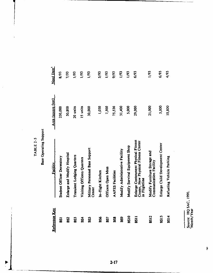
The purpose of BOS facilities is to provide all those facilities and activities thatare necessary for the day-to-day operation of the base and for support of the host andtenant mission. This also includes all Morale, Welfare, and Recreation facilities.Upgrades to existing BOS facilities and construction of new BOS facilities are requiredto accomodate the realignment. These requirements, presented in Table 2-5, constitutethe BOS complex. Other significant space requirements in addition to those for theprimary facilities include space for access drives and loading docks for logistics-relatedfunctions and privately owned vehicle parking for employees and visitors. Siting criteriaincluded the consideration of access and locations convenient for users. While theBOS complex forms a functional unit, its elements are physically dispersed throughoutthe base. Each element has distinctive siting requirements that are intrinsic to thatelement's function.
The Student Officer Dormitory will house the SUNT students while they arereceiving training. The dormitory is planned to be adjacent to the buildings in theAcademic Complex in the cantonment area. The Transient Lodging Quarters is alsoplanned to be adjacent to the Academic Complex buildings. These quarters willprovide temporary housing for enlisted personnel assigned to Beale AFB. VisitingOfficers Quarters are planned near, and slightly west of, the Academic Complex. Themajor siting concern, which was common to all three of these living facilities, is toplace them near facilities their occupants will use most heavily. Therefore, they are
i2-16oil
40 0 - ý - D CD ) (D
o 3 3 0 0 0 0 0 40 0 0) 0ca. 0 o 0ý .% wt 0 0 C 0 0 0 0D 0 G0
00 C 0 C; C ; 0Z 0ý CpC Z, C; 0 0o) t u C 0 - - en~ -1 CA 0 - '
C..q
0606
cu CL
0 -
C.4) 6. C i 4) C
0 al~
4)4 v LL1. 0. E.
4u..u C .
OS. 0~C # 0 C -, ) .
0)I - u w ce
Cu 2-17

planned for locations in or near the Academic Complex and in the cantonment area.To provide food service close to the Academic Complex, where SUNT personnel willwork and SUNT students will both live and study, an Officers Open Mess is plannedeast of the Academic Complex.
Several additional BOS facilities are planned to be built or modified within thecantonment area. Locations for n,-w buildings were chosen to be close to similaractivities, near concentrations of base personnel, and to have good access. Thesefacilities include Army Air Force Exchange Service (AAFES) facilities--a newCommissary, a small Shop and Gas convenience store, and expansion of the BaseExchange. The Commissary is planned for an area northeast of 25th street andsoutheast of B Street and was planned independently of the realignment action. TheShop and Gas is planned for the south quadrant of the intersection of A Street andDoolittle Drive. Another new facility will be the Military Personnel Base SupportCenter, also known as the Consolidated Base Personnel Office. Facilities to bemodified or enlarged in the cantonment area will include Administrative Facilities,the Fitness Center, the Furniture Storage and Communication Facility, and the BaseExchange.
All BOS facilities planned for the cantonment area will be within the boundariesof IRP Site 22. Four possible UST locations were detected by magnetometer in thecantonment area south of Warren Shingle Drive. Investigation of potential locationsand removal operations are proceeding and will be completed prior to initiation ofconstruction activity.
While most BOS facilities, existing and planned, are in the cantonment area, afew exist on and are planned for other parts of the base. The Hospital and ChildDevelopment Center, located in the eastern part of the base near the family housingarea, will be enlarged.
Four facilities in the BOS are planned for the flightline. The specificrequirements of personnel on the flightline and the nature of these facilities requiretheir placement there. These facilities include an In-Flight Kit-hen and a PhysicalFitness Center. Modifications to an existing building will house the Survival EquipmentShop. Parking for Refueling Vehicles will be added adjacent to existing parking.
2.2.33 Academic Complex
The primary facilities needed to provide the academic component of the 323rdFlying Wing's training mission at Beale AFB are listed in Table 2-6. The squarefootage shown in the area column is the footprint for the amount of land area requiredfor each facility.
The Academic Complex must provide all the facilities for navigator trainingother than those directly related to the aircraft at the flightline. Space is required inthe main complex for classrooms, navigator and electronic weapons officer simulators,aerospace physiology functions, associated headquarters and student squadronoperations, and a Parasail Area, which will be used for parachute training. TheAcademic Complex-one .functional unit-will occupy two sites because of the specific
2-18

V c
C)>
00 Q
C', 0ý -o C ad
< 06
CL)
I05
00
Go 4
ZS w
U))
<o o ;;I- < A A
001-
W %0 00
62 1

requirements for the Parasail Area, which are discussed later in this section. Thefacilities that will be adjacent to one another will be referred to as the main AcademicComplex, whereas the functional Academic Complex refers to these facilities and theParasail Area.
Four siting alternatives were considered for the main Academic Complex, allin the cantonment area. Three primary siting criteria for this Complex were integrationof the planned facilities with the Base Comprehensive Plan, proximity to communityand administrative support functions, and visual enhancement of the southern portionof the cantonment area, which serves as a "gateway" for visitors to the base.
One site considered is in the west-central part of the cantonment area, southof Doolittle Drive and between B and C Streets. This site is not close to somehighly-used support facilities, nor does it allow for future expansion. It also would nothave a positive impact on the visual quality of the gateway.
Another site considered is adjacent to the site described above, south of the ballfields and west of C Street. This site is not close to support facilities and encroacheson land projected for other uses in the Base Comprehensive Plan.
A site on the eastern edge of the cantonmen t area, northwest of Warren ShingleDrive, southwest of a drainage channel, and east of A Street was also considered. Inaddition to the large drainage forming the approximate boundary of the site, othersmall drainage channels cross the site, posing potential environmental and constructionproblems. Also, SUNT use of this site would not integrate well with the BaseComprehensive Plan.
The selected site is at the southern edge of the cantonment area, south ofWarren Shingle Drive between A and C Streets. No major negative features areassociated with this site and it provides a visual improvement for the gateway area.
The Parasail Area presents an unusual siting requirement for a large, open, flatarea because it will consist of intersecting 3,000-foot asphalt runways within a 3,000-foot diameter circular road. The runways will be used by motor vehicles that will towparasail trainees as they practice parachute techniques; therefore, the siting criteriashould emphasize safety considerations for trainees. In addition, support facilities, suchas a storage building, phone lines, and sanitary facilities, will be required. Alternativelocations for this use are still under evaluation. Three potential sites, which aredescribed below, mee*, the basic criteria of flat open areas.
A site considered is south of Doolittle Drive, between the cantonment and theflightline areas. Concrete foundations and roadbeds remaining from previousdevelopments would have to be removed before construction of a Parasail Area couldbegin. Washes associated with the Hutchinson Creek drainage would be filled toprovide level ground. A U2 flight track crosses the airspace above this site. The U2may fly as low as 500 feet, while a parasail trainee may be towed as high as 300 feet;therefore, this site allows a very small margin of safety (200 feet) for parasail traineesand U2 aircraft. Currently, this site is used as a bivouac area by Beale AFB. Thistraining activity would have to be relocated if the Parasail Area is located here.
2-20
Another site considered is south of Warren Shingle Road, between thecantonment and the flightline areas, and south of the site described above.Foundations and roadbeds from previous development would require removal, andwashes associated with Hutchinson Creek, whikh may include some wetlands, wouldneed filling and leveling. This location is rather close to the base railroad siding andtank farm where fuel is delivered and stored, which may p•isent a potential safetyhazard.
The preferred site for the Parasail Area is near the southern base boundary,west of South Earle Road. Although somewhat distant from the main complex, thissite is the most economical, requiring no removal of previous development. Also, lessgrading and filling would be required because this area is generally flat; however,access roads to the site will need to be upgraded. Additionally, vernal pools are knownto exist in this area, although no complete survey for them has been conducted. Thearea in which this site is located has been identified for possible location of artificalwetlands habitat to replace similar habitat that may be lost due to any futureconstruction.
2.2.3.4 Family Housing
The Air Force has conducted a market analysis to determine the number ofadditional permanent housing units needed to support the realignment of Beale AFB.However, a final determination of the number of units needed, if any, has not beenmade. Build-to-lease housing is proposed for construction under the authority ofSection 801 of the 1984 Military Construction Authorization Act (10USC 2828(g)).Build-to-lease (or Section 801) housing is constructed by a private developer, usuallyon privately owned land. The housing will be leased to the Air Force who will operateand maintain it for 20 years. Infrastructure and utility systems are required to beturned over to their respective municipality, tax district, or utility company The AirForce has the right of first refusal to purchase the property should the privatedeveloper wish to sell. Section 801 housing can be developed on government-ownedland only with special permission of the Secretary of the Air Force, permission thatis infrequently given.
A preferred site has not been chosen at this time. Three sites, each of morethan 100 acres, are being considered for possible construction of Section 801 housing.One site is on base, just south of existing housing, on Lark Drive and East GarryannaDrive. This land has been identified by the Government Services Administration asexcess property to be sold. However, its current government ownership will posedifficulties in qualifying for Section 801.
The other two sites are off base. Both are south of the base, near and north ofthe town of Wheatland. One is at the edge of the town and the other is between thebase and the town. If it is determined that additional housing is required, the impactfrom its construction and use will be assessed in a separate NEPA document.
2-211.

2.2.3.5 Demolition Candidates
Ten structures will be demolished to make way for planned new construction.All are in the cantonment area in or adjacent to the planned site of the mainAcademic Complex. The structures are listed in Section A of Table 2-7 and shownon Figure 2-2. An additional four structures in the same area are being consideredfor removal but their demolition has not been approved by the base. They are listedin Section B of Table 2-7 and also shown on Figure 2-2. The potential for thesestnrctures to be qualified for inclusion on the National Register of Historic Places hasnot been analyzed. Provisions of .he National Historic Preservation Act, includingconsultation with the SHPO, will be implemented prior to demolition. In addition, theDOD Memorandum of Agreement with the ACHP and the National Conference ofState Historic Preservation Officers concerning World War II temporary buildings mayapply to some of the demolition candidates. Pertinent provisions of the Agreement willbe adhered to, if appropriate.
2.3 SUMMARY OF MAJOR ISSUES AND POTENTIAL IMPACTS
Based on the results of discussions with USAF personnel and letters receivedfrom State and Federal agencies in response to the NOI, the scoping process hasidentified several areas of potential concern associated with the realignment of 3ealeAFB. Table 2-8 summarizes potential impacts of the realignment for the areas ofpotential concern.
2-22

TABLE 2-7
Buildings Considered for Demolition
A. Buildings that Beale AFB is prepared to have demolished.
Reference BuildingKey Number Facility
DM1 2195 Commissary Warehouse
DM2 2193 Hazardous Material Storage Facility
DM3 2198 High Voltage Electrical SwitchingStation
DM4 2174 Decontamination Facility
DM5 2i76 Dormitory
DM6 2177 Dormitory
DM8 2185 Morale, Welfare, and RecreationRental and Zone C Operations
DM9 2184 Incinerator
DM10 2180 Veterinarian
DM14 2131 Military Working Dog Kennels
B. Buildings that could be removed; however, demolition has notbeen approved by Beale AFB.
DM7 2175 Dormitory
DM11 2179 Class 6 Storage, Social Actions, andArea Defense Council
DM12 2171 Communications Squadron
DM13 2172 Communications Squadron
Source: HQ SAC, February 1990.
2-23

c
C. 3
ME 0
C6C
Va tc c c
ed v -Dow r-
L. C-ý 0
C S . v :9 'wE u ~ O - w- ~ 5t 8C-
00 c 0 0
*** CNo V
SO ;I w" IX 2 w w
EEO. SS0c V c CC
0-
C - ;% , - 0;4m m c
to
0 A... ceZ- C wd wz i
Cv r "C "
lo Ov I~ .'00 it 02 .2W z u
"Coo ~ ~ 0 C0
*V--c
r'J 0 2 2-24

e -c 02
C~~ 2 1. -C
C 20
ov -06u n .
C 06) V ' CL C
o .- ... 0, > 1-
D o c~C 0 C
0 ;o2~~~t I~ 'o a
- em 4-1 4
a ) -B
- ~10 -
C o 0
a 4)V rn
0.
.00
22C U A2
Ad~*0
2.cc
.2 z
02-25 4

va Q.
*06
-; C
4)a 0 cc
4)6oa .aCL
4Go c 04 0
c-4 41 -.
00 cZ-. 0). .
E E.
4) Go
44 *7
at)4"1
u z
44P 4)
C I?
-2-2

z z z z z4CC
0 )4
0..0
00~ .0
C w 0~.. 4I 5 6 ~ .
I ce cw v £ Ur
.CE -C -c
V V
cu -C
0 =
60 <
1! .: -it - -r,
9, v C.W=
-V -Caa 22
2-2

3.0 AFFECTED ENVIRONMENT
3.1 INTRODUCTION
3.1.1 Histo
Camp Beale, named for General Edward Fitzgerald Beale, opened in October1942 with more than 86,000 acres of land. During World War II, the camp was usedas an infantry training center, a personnel replacement depot, and a prisoner-oi-war(POW) camp. The POW camp may be considered of historic importance. During thewar, the camp supported a military population of more than 60,000 personnel.
Camp Beale was declared surplus in 1947, and in early 1948, transfer to theUSAF was arranged. The base was used for bombardier-navigator training. In 1951,Headquarters USAF announced the reactivation of the Beale Bombing and GunneryRange as a training site and officially changed the name to Beale Air Force Base.
During Beale's early years in the Air Force, the base underwent a number oforganization changes, at times being a part of ATC, Continental Air Command,Aviation Engineer Force, and finally SAC. Early in 1959, it was announced that the14th Air Division would be assigned to Beale AFB. In July 1959, Beale received itsfirst KC-135 jet strato tanker, with B-52 bombers arriving shortly afterwards. InSeptember of 1959, it was announced that Beale was to be the support base for threeTitan missile sites. By 1965, the Titan I missile program had been discontinued, andthe squadron was deactivated. Coupled with the deactivation of the missile unit,however, was the beginning of a new era in the history of the base with the activationof the 4200th SRW, later redesignated as the 9th SRW.
3.1.2 Mission
The mission of the 9th SRW is to provide global aerial reconnaissance and airrefueling support in wartime in accordance with provisions of the Emergency WarOrder. In peacetime, reconnaissance flights and reconnaissance air refueling supportare conducted in response to the Peacetime Aerial Reconnaissance Program andcontingency tasking from the National Command Authorities and the Joint Chiefs ofStaff. At the same time, the wing supports the requirements of unified and specifiedcommands. After raw intelligence data are collected by reconnaissance aircraft, the 9thSRW processes, reports, and disseminates intelligence products to specified civilian andmilitary users.
The major tenant organizations at Beale AFB are the 14th Air Division andthe 7th Missile Warning Squadron. The 14th Air Division's mission is to ensure thatunits assigned to the division are capable of conducting worldwide strategicreconnaissance and maintaining an airborne command post in continuous operation.
The primary and secondary missions of the 7th Missile Warning Squadron'sPrecision Acquisition Vehicle Entry Phased Array Warning System (PAVE PAWS)are to provide warning and attack assessment of a sea-launched and/or intercontinental
3-1
ballistic missile attack aimed at the continental United States and Southern Canada.The tertiary mission is to provide surveillance, tracking, reporting, and identificationof objects in space through a system known as Space Track.
Existing personnel who carry out these missions at Beale AFB are detailed inTable 3-1. Flight activity that fulfills Beale AFB mission objectives averagesapproximately 665 operations per day (HQ SAC, 1990). An operation is one takeoff,one landing, one low approach, or one touch and go.
3.1.3 Existing Develonment
Development at Beale AFB is basically confined to three functional areas--theflightline area, the cantonment area, and the family housing area. Figure 3-1 presentsthese three areas in relationship to one another.
The flightline area, besides containing the mission-essential runway andassociated taxiway and aprons, includes aircraft operation and maintenance facilities,mission support activities, supply activities, and ground vehicle maintenance and fuelingactivities. The runway is 12,000 feet long and 300 feet wide, with asphalt overruns of1,000 feet on the south and 2,250 feet on the north. The runway is capable of handlingany aircraft in the Air Force inventory. Additionally, Explosive Ordnance Demolitionand fire protection and training functions are carried out in this area, as are someadministrative operations. The flightline area has a small complement of communitycommercial and service facilities, as well as a small recreational facility.
The cantonment area supports many of the administrative functions andorganizations operating in the flightline area. This area is also the central businessdistrict for the base, dominated by administrative, community commercial,unaccompanied housing, and industrial uses. Social, maintenance, medical, andspiritual facilities are located here, as are base engineering and environmentaloperations.
The family housing area provides base housing for accompanied officers andenlisted personnel. A fire station and an administrative office are also present here,along with a number of other community service, commercial, and recreationalfacilities.
3.2 GEOLOGY. TOPOGRAPHY
3.2.1 Geoloic Setting
Beale AFB is approximately 40 miles north of the City of Sacramento in theeastern part of the Sacramento Valley. The Sacramento Valley together with SanJoaquin Valley to the south constitutes the Great Valley of California (Figure 3-2).Extending from Redding in the north to Bakersfield in the south, this valley is about60 miles wide, bordered to the east by Sierra Nevada Foothills and to the west by theCoast Ranges.
3
3-2

TABLE 3-1
Units Assigned to Beale AFB as of 8 February 1990
Military Civilian Total
14 Air Division 71 22 939 Strategic Reconnaissance Wing 241 6 2475 Strategic Reconnaissance Training 39 1 4099 Strategic Reconnaissance Squadron 53 - 53349 Air Refueling Squadron 102 - 102350 Air Refueling Squadron 104 - 1049 Avionics Maintenance Squadron 133 - 1339 Field Maintenance Squadron 304 9 3139 Organizational Maintenance Squadron 357 1 358609 Organizational Maintenance 315 4 319
Squadron9 Reconnaissance Technical Squadron 57 2 59814 Supply Squadron 284 33 317814 Transportation Squadron 117 28 145814 Combat Support Group 42 28 70814 Civil Engineering Squadron 263 179 442814 Security Police Squadron 233 1 234814 Services Squadron 64 2 66814 Mission Support 54updron 89 27 116814 Strategic Hospital 381 40 421814 Comptroller Squadron 46 19 65Detachment 6, 3904 Management 8 3 11
Engineering Squadron7 Missile Warning Squadron 65 7 721360 Audiovisual Squadron 15 1 16Detachment 625, 3753 Field Training 28 - 28
SquadronDetachment 11, 9 Weather Squadron 15 2 171883 Communications Squadron 153 7 160Detachment 6, 2163 Communications 11 - 11
GroupAir Force Commissary 71 43 114Air Force Legal Services 2 - 2Air Force Office of Special 5 6Investigations
TOTAL 3,668 466 4,134
Source: Capt. Mark K. PlasterDet. 6,3904 MES/SACMETBeale AFB
3-3

L I
UJ a114z offU
Ch
J z ISO
ISO LoI <*:~-:*cc
5
zuj U-
z L
A~j 0
3-4

4, 0 50 100 MILES
5%
BASIN RANGES
' C ,.....BEALE AIR FORCE BASE
I 0
.A7
Cx
FIGURE 3-2GEOGRAPHIC SETTING
. 13-5
19k1
d• " • - -- - • •u l m | tNan a Iam i i

3.2.2 Geomorpihi!
As shown on Figure 3-2, Beale AFB lies on the boundary of the Great ValleyProvince and the Sierra Nevada Province. The Sierra Nevada Provinc..; is a stronglyasymmetric mountain range. It has formed as a huge block of the earth's crust thatis being uplifted along a fault system on the east side of the range and tilted westward.This has resulted in the Sierra Nevada having a long, gentle western slope and a steepeastern escarpment.
The Great Valley Province was formed as a structural downwarp between theCoast Range Province on the west and the Sierra Nevada Province on the east. Ithas been filled with alluvial deposits derived from the erosion of the Sierra Nevadaand the Coast Ranges. Extending more than 400 miles from north to south andaveraging about 60 miles wide, the Great Valley comprises the Sacramento Valley inthe north and the San Joaquin Valley in the south. On its eastern boundary, thealluvial deposits of the Great Valley overlap bedrock of the Sierra Nevada block,which continues to slope gently to the west.
Because of its location on the boundary of the two provinces, Beale AFBdisplays characteristics of both the Great Valley and the Sierra Nevada. The westernportion of the base is relatively flat grassland, characteristic of the Great Valley.Moving eastward, the plains become low rolling hills that gradually merge with thefoothills of the Sierra Nevada.
Three geomorphic units characteristic of the Great Valley Province are presentat Beale AFB--river flood plains and channels, low alluvial plains and fans, anddissected uplands. These units are shown conceptually on Figure 3-3.
River plains and channels lie along the major drainages at Beale AFB. Asthese streams have meandered in recent geologic time, they have deposited sands andgravels along their channels, and silts and clays on their flood plains. Where present,these deposits may range in thickness up to about 100 feet on the western edge of thebase. Low alluvial plains and fans comprise most of the western part of the base. Thisunit is generally flat to gently rolling and is composed of alluvial deposits of mainlyPleistocene age. Unlike the river flood plains and channels, little or no deposition istaking place on this surface and, consequently, a mature soil profile has developed,which contains cemented sediments in many locations.
Dissected uplands form the eastern edge of the Great Valley, and comprisemost of the central portion of Beale AFB. This unit ranges from gently rolling landto dissected hills, with relief of up to several hundred feet. Dissected uplands arecomposed of unconsolidated to semiconsolidated continental deposits of mainlyPleistocene and Pliocene age (Poland and Evenson, 1966). This surface is beingeroded at the present time.
Moving eastward into the foothills of the Sierra Nevada at Beale AFB, thetopography gets progressively steeper, and outcrops consist of mostly older consolidatedsedimentary rocks of Oligocene to Pliocene age. On the eastern boundary of the base
I
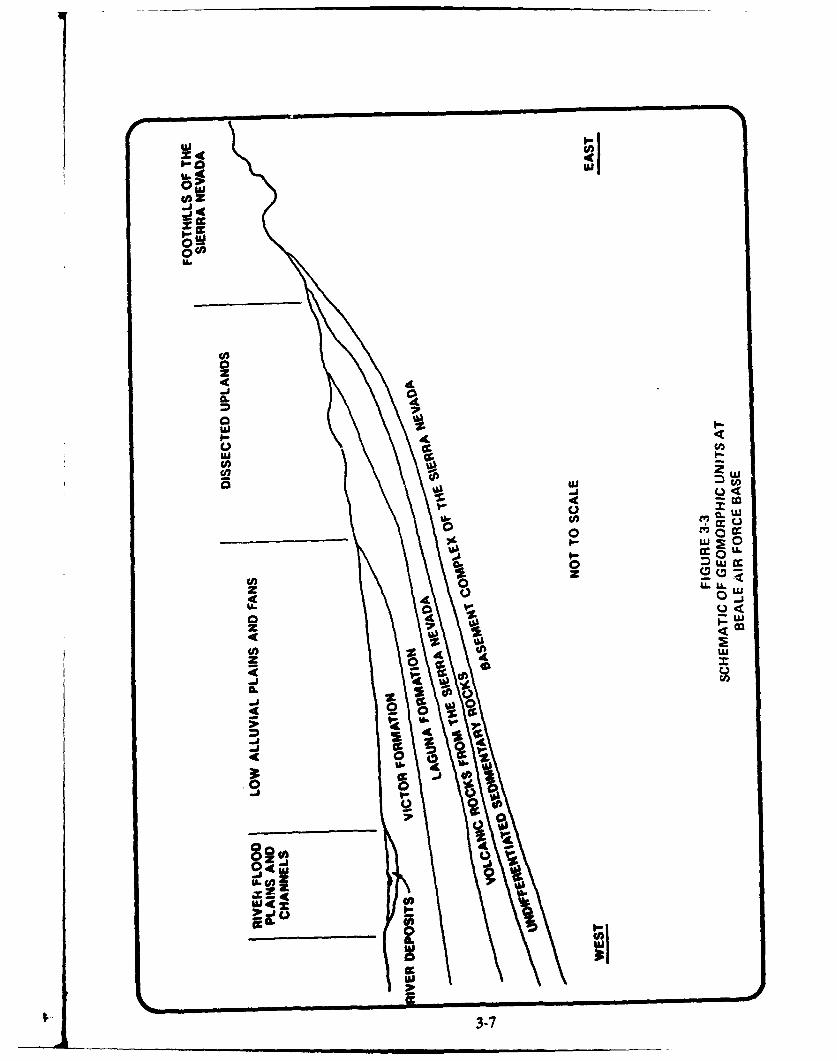
A.'0'
02m
00I'.
z
4L W0L 0
ac
tou
000 0
80 0
ov 4 $ A
4 00
-3-
are exposures of the crystalline basement rock of the Sierra Nevada, which range in age
from Mesozoic to Paleozoic.
3.2.3 Seismic Activity
The most recent seismic activity in the vicinity of Beale AFB was the minormovement that occurred along the Cleveland Hill Fault about 25 miles north of thebase and accompanied the 1975 Oroville earthquake sequence. Other mapped faultsin the area include the Highway 49 lineament about 20 miles east of Beale AFB anda shear zone, located a few miles east of the base, that trends in a northwesterlydirection. There are no known active or inactive faults within the boundaries of BealeAFB (Black and Veatch, 1985).
3.2.4 Soils
Soils at Beale AFB have been recently mapped by the United States Departmentof Agriculture (USDA), Soil Conservation Service (SCS, 1985). The formation of soilat a particular location is controlled by the geology, landforms, relief, climate, andvegetation at that location. The resulting characteristics of a particular soil, such as itstexture, permeability, and mineralogy, may affect the movement of groundwater.Detailed soil maps, profile descriptions, and tables of engineering properties may befound in the Soil Survey (SCS, 1985).
Much of the western portion of the base is covered by San Joaquin loam. Thisis a moderately deep, moderately well-drained soil formed on old alluvial terraces atan elevation of between 60 and 130 feet National Geodetic Vertical Datum. SanJoaquin loam typically contains a layer of hardpan at a depth of between 20 and 40inches. The infiltration rate is moderate (0.6 to 2.0 inches per hour) above about 16inches in silt and silty clay, and very slow (less than 0.06 inches per hour) below thisdepth in clay.
Redding-Corning gravelly loams cover most of the central part of the base,including the flightline and cantonment areas. These soils are moderately deep tovery deep and are well-drained. They form on old alluvial terraces at an elevation ofbetween 110 and 250 feet. A layer of hardpan is commonly found at a depth ofbetween 20 and 40 inches. The infiltration rate is moderate (0.6 to 2.0 inches perhour) in the upper 2 feet in clayey and silty sands and gravels. Below this depth, thepermeability is very slow in clays.
Pardee-Pardee Variant complex and Pardee gravelly loam covers much of thenortheastern part of the base. These are shallow, well-drained soils formed in gravellyand cobbly alluvium on old, dissected alluvial terraces above unrelated igneous bedrockat an elevation of between 120 and 250 feet. The infiltration rates of the soils aremoderately slow to moderate (0.2 to 2.0 inches per hour) in silty and clayey sands andgravcls.
On the northeastern edge of the base in the foothills between elevations ofabout 125 and 1,100 feet are Auburn-Argonaut loams. These soils are shallow tomoderately deep and well-drained, formed in residuum from basic metavolcanic rock.
3-8

Bedrock may be found at depths of 10 to 40 inches beneath the Auburn-ArgonaLtloams. Infiltration rates range from very slow to moderate (less than 0.06 to 2.0 inchesper hour) in silts and clays.
Perkins loam and Conejo loam are found along the drainages at Beale AFB.These are very deep, well-drained soils formed on stream terraces in alluvium derivedfrom mixed sources. Perkins loam tends to be found along the upper reaches of thedrainages. Its permeability is moderately slow (0.6 to 2.0 inches per hour), and it iscomposed of silts and clays, with some silty and clayey gravel below about 5 feet indepth. Conejo loam is normally found in the lower reaches of the drainage courses.This soil shows a moderate infiltration rate (0.2 to 2.0 inches per hour) in silts andclays.
3.3 AIR OUALITY
3.3.1 Climate
The regional climate of Beale AFB is controlled by its interior valley locationbetween the Coastal Range and the Sierra Nevada mountains. Because of its inlandlocation, the valley experiences warm summers and cool winters. Pacific stormsmigrating across California contribute to most of the annual rainfall that occursbetween November and April. The average annual daily maximum temperature is 73degrees Fahrenheit (F), while the average daily minimum is 47 degrees F. Snow fallson occasion in the Sacramento Valley. Relative humidity is variable and the areaexperiences approximately 34 days of fog annually (Ruffner, 1985).
The prevailing wind direction at Beale AFB is southwest, and averages 5.6 milesper hour (mph) during the simmer and 5.5 mph during the winter. The annualaverage wind speed is 5.6 mph (CARB, 1984). Atmospheric temperature inversions(air temperature increasing with height) are common in the region, creating a cappingeffect and holding air pollution near the surface. These inversions occur particularlyduring the late evening and early morning hours, and break down during the day dueto surface convective heating and atmospheric mixing. During the summer, the baseof these inversions is usually between 800 and 1,000 feet during the morning, and liftsto approximately 6,000 feet above ground level by afternoon. During the winter, thebase of the morning inversion is approximately 1,200 feet, but lifts only to 3,000 feetby afternoon due to weaker surface convective heating (Holyworth, 1972). An analysisof 5 years of meteorological data from the Sacramento Executive Airport showed thatstable conditions exist approximately 75 percent of the time.
3.3.2 Air Resources
Beale AFB is located in southern Yuba County and occupies portions of theSacramento Valley and Mountain Counties Air Basins for which the California AirResources Board (CARB) reports ambient air quality data. No air monitoring stationsare located on the base. The closest air monitoring stations reporting to the CARBare Auburn, Yuba City, Pleasant Grove, and North Highlands. These stations monitorozone (03), sulfur dioxide (SO2 ), nitrogen dioxide (NO 2), carbon monoxide (CO), and10-micron or less particulate matter (PM,o). The Auburn monitor, located
3-9
approximately 16 miles southeast of Beale AFB, monitors 03 and PM,. The PleasantGrove station is situated approximately 20 miles south of Beale AFB and monitors 03;and the North Highlands monitor is approximately 5 miles south of the Pleasant Grovestation and samples SOý, 06, CO, and NO,. Air quality background concentrations for1985 through 1987 collected at these stations are presented in Table 3-2.
Maximum background air quality data from the above-mentioned table arecompared to National Ambient Air Quality Standards (NAAQS) and CaliforniaAmbient Air Quality Standards (CAAQS) in Table 3-3. This table shows that Stateand Federal 1-hour 03 standards and State 24-hour PMK standards were exceeded atleast once within the 1985-1987 collection period.
The United States Environmental Protection Agency (EPA) has designatedYuba County an attainment area for all pollutants except 03. An attainment area isa region or air basin in which monitored air quality levels are in compliance with theNAAQS. In addition, the background data listed in Tables 3-2 and 3-3 shows that the24-hour PM,0 CAAQS standard of 50 ug/m& was violated at the Yuba City station inSutter County at least once during the 1985-87 sampling period.
CARB also reports the average daily air emissions for air basins and countiesbased on information provided to them by each Air Pollution Control District. Thisinformation for Yuba County for 1983 (the most current available) is presented inAppendix A. Sources of emissions are presented by category. In this inventory, aircraftoperating from Beale AFB are categorized under Other Mobile Sources as Aircraft-Government. This category of sources contributed less than 6 percent of the totalorganic gases, 7 percent of the reactive organic gases, slightly more than 2 percent ofthe carbon monoxide, and less than 5 percent of the oxides of nitrogen emitted county-wide.
A complete air emissions inventory reflecting current base operations (stationarysources and aircraft) is not available (Personal Communication, Capt. Sherman, BealeAFB). The Yuba County Air Pollution Control District has issued a facility-widepermit for most stationary source emissions at Beale AFB. The permitted equipmentincludes the following: five paint shops and paint spray booths; six degreaser andsolvent tanks; 31 fuel storage tanks and 50 tank trucks; two incinerators; 157 boilers,furnaces, and hot water heaters; 132 pieces of aviation ground equipment on theflightline; 64 power generators at the power production shop; and 66 generatorselsewhere on base. The cumulative air emissions from these sources are permitted atthe following levels: 70 tons per year total hydrocarbons, 100 tons per year NO,, 22tons per year SO., 3.7 tons per year PM,., and 73 tons per years CO. These do not,however, reflect the total composition of base operating emissions because permittedsources contribute only part of the total operating emissions.
Existing aircraft emissions at Beale AFB have been compiled by HQ SAC usingthe Aircraft Engine Emissions Estimator, November 1985. The number of flightoperations per month per aircraft type were input to determine the amount ofemissions produced. The inventory excludes transient aircraft that had less than oneoperation per month. Data to determine emissions from U-2 aircraft are classified
3-10
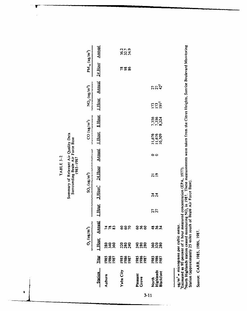
r- 42N00
AJ4 o 1
CD
4)
< 00
E- -I
r- r- OoCZ
C.0
00O c o 0Q0 0 ev , c
w- IR 0 "s -0 % 40
o,0,0 0 0 0 0 ' ' ,0
~ V.
<.0 todlQ u
E3-1

TABLE 3-3
Maximum Background Air Quality ConcentrationsSurrounding Beale Air Force Base
1985-1987
MaximumBackground
Averaging Concentration CAAQS NAAQS(Up (up
Pollutant .. Pgriod -In?) - -Id
03
1 hour 360 180 240
Annual 83 -
NO,1 hour 194 470 -
Annual 42 - 100
CO1 hour 11,700 23,000 40,000
8 hour 8,520 10,000 10,000
so,1 hour 27 655 -
3 hour 24 - 1,30024 hour 21 131 365
Annual 0 - 80
PKI
24 hour 98 50 150
Annual 36.2 30 50
ug/rr? = micrograms per cubic meter.Source: CARB, 1985, 1986, 1987.
3-12

and, therefore, unavailable for inclusion in this inventory. Annual emissions in tonsper year for aircraft at Beale AFB are presented below.
Carbon Monoxide 2,116 tons/yearHydrocarbons 839 tons/yearNitrogen Oxides 399 tons/yearSulfur Oxides 64 tons/yearParticulates 22 tons/year
3.4 WATER RESOURCES
3.4.1 Groundwater
Groundwater movement in the region has historically been in a direction fromthe Sierra Nevada foothills eastward to the Feather and Sacramento Rivers.- Until theearly part of this century, these river systems served as groundwater discharge systems.However, extensive farming and irrigation in the Sacramento Valley area rapidlylowered the water table and altered the direction of groundwater flow, thus changingthese rivers from discharge to recharge systems (Aerovironment, 1987).
Groundwater generally flows in a westerly/southwesterly direction across thebase. The most obvious groundwater characteristic in the area is intense drawdownsouthwest of the base boundary caused by irrigation pumping. Between 1945 and 1974,the water table fell about 60 feet, then stabilized in the mid-1970s. However, between1977 and 1980, the water table declined sharply once more in response to drought andincreased irrigation for rice production (Aerovironment, 1987). Since 1980, the waterlevel has risen markedly as a result of increased precipitation and lower riceproduction. Nevertheless, the overall drawdown has been sufficient to alter thedirection of local flow in the area of the base well-field from west to nearly south.
It is assumed that groundwater tapped for base use is basically unconfined exceptwhere local clay/silt lenses cap the aquifer to produce semiconfined conditions. Freshwater occurs at a depth of between 300 and 500 feet below the surface under most ofthe base.
3.4.2 SuracWate
Runoff from the base is collected and converged offsite by three principaldrainage systems-Dry Creek, Hutchinson Creek, and Reeds Creek. With the exceptionof Dry Creek, these streams are primarily intermittent (Figure 3-4). Because ofimpervious soil conditions, lack of topographic relief, and infrequent but sometimesheavy precipitation, the streams in the western portion of the base exhibit wide floodplain areas.
Dry Creek originates to the east of the base and flows to the southwest as BestSlough and Dry Creek, eventually discharging into the Bear River. Hutchinson Creek,which is the largest surface water system on the base, flows mainly southward on baseand eventually joins Reeds Creek. Reeds Creek flows mainly westward through the
3-13I.

U-
114
I. cjn0 M LL LU
13
CID 0/ naCg
LLJ z
0 ~za wr >
p : 1(
c~Ju.
IA Q
3.14
base and generally parallels the northern base boundary. Reeds Creek and HutchinsonCreek converge before they drain into Plumas Lake southwest of the base.
Both the flightline and the cantonment areas drainage is collected by HutchinsonCreek and its tributaries. Surface runoff from the family housing area is collected bytributaries of Dry Creek.
3.4.3 Water Ouality
3.4.3.1 Groundwater
Natural water quality at Beale AFB is generally good, with base water supplywells (Page, 1980) and most monitoring well samples meeting national primary andsecondary drinking water standards. Groundwater in the northern part of the base inthe vicinity of the flightline is recharged in large part by infiltration from-the YubaRiver located just north of the base boundary. This groundwater is low in TotalDissolved Solids (TDS) (161 to 233 milligrams per liter [mg/1]) compared to thesecondary drinking water standard of 500 mg/l). Nitrate is generally less than 10 mg/l,ranging from 3.4 to 12.5 mg/l. These values are higher than those for pristinegroundwater, but lower than those for other areas at Beale AFB and well below thenational primary drinking water standard of 45 mg/l. Sulfate levels are all well belowthe 250 mg/l secondary drinking water standard (CH, M Hill, 1990).
Groundwater in the central part of Beale AFB is further from river rechargeareas. The central area groundwater had higher TDS (260 to 385 mg/I) than in eitherthe north or south areas. Nitrate levels, while still below secondary drinking waterstandards, were higher than in the north area, possibly because of fertilizer or cattlegrazing in the area or irrigation of the golf course with water discharge from thesewage treatment plant (STP). Sulfate ranged from 10 to 65 mg/l, well below thesecondary drinking water standard of 250 mg/I (CM2 M Hill, 1990).
Groundwater in the southern part of Beale AFB is recharged largely on base byinfiltration from Dry Creek, Best Slough, and Hutchinson Creek; from precipitationeast of the base; and to a lesser degree from the Bear River south of the base. TDSgenerally ranged from 192 to 292 mg/l. Nitrate was higher here than in the north area,possibly related to fertilizer or cattle grazing in the area, and generally ranged fromlevels too low to be detected to 25 mg/l near the STP. Sulfates generally ranged from5 to 48 mg/l (CM2 M Hill, 1990).
Water from supply wells at Beale AFB is generally of good chemical quality.However, water from six base water supply wells exceeded the national secondarydrinking water standard for manganese of 0.05 mg/l when tested in 1975. Dissolvedmanganese is objectionable in water because it affects taste, stains plumbing, andaccumulates as deposits in distribution systems (Page, 1980). Complaints by waterusers of discolored water and staining of laundry washed in water with high manganeselevels are received approximately once a month. During periods of high demand, thebase is forced to use water from the wells known to have high manganese levels. Thewater distribution system is frequently flushed to remove accumulated deposits
3-15

(Personal Communications, Tony Guerrero, Beale AFB, 1990). Manganese was also
present in off-base agricultural and water supply wells.
3.4.3.2 Surface Water
Water quality parameters were measured in surface water samples at Beale AFBas part of the IRP Stage 2-1 Remedial Investigation. Results of these analyses andrelated quality control data are presented in Appendices A and F of that report(C-IM Hill, 1990). The following discussion is summarized based on these results.
Surface water was sampled within, and at three different tributaries ofHutchinson Creek. TDS varied from 69 to 169 mg/l in the Hutchinson Creek samples.Surface water type varied in Hutchinson Creek ranging from sodium-calciumbicarbonate to magnesium-calcium bicarbonate to sodium-magnesium bicarbonate.Surface water at the west side drainage ditch, which flows to Hutchinson Creek, hadTDS of 157 mg/l and was a calcium-sodium bicarbonate type.
Surface water quality was not measured in other drainage systems at Beale AFB;however, it can be assumed to have similar characteristics to those reported forHutchinson Creek.
3.5 BIOLOGICAL RESOURCES
3.5.1 Vegetative Resources
3.5.1.1 General
Beale AFB contains extensive open space and a variety of vegetation, includingannual grassland, freshwater marsh, oak woodland, riparian woodland, and vernal pools.Most of the base is undeveloped, consisting primarily of annual grasslands on gentlyrolling hills and flats. Freshwater marshes and oak and riparian woodlands arerelatively uncommon on the base, especially in areas where SUNT facilities will belocated.
Annual grasslands are dominated by a variety of native and introduced grasses,including wild oats, barley, and Italian rye grass. Several spring flowering herbs werealso observed, including brodiaea, wild hyacinth, and vetch. Many of the proposedfacilities will be in areas where annual grassland vegetation occurs.
Vernal pools are quite extensive west of the existing runway, surrounded byannual grassland. A base-wide wetland inventory was conducted in 1985 by the USDASCS. During this survey, all wetlands (including larger vernal pools and riparianwetlands) were classified and mapped.
"V iJa.-, pools ie -all, shallow bodies of water that occupy depressions ingrassland and woodland areas. They are filled with water in the winter and are dryin the summer. The bottom of the pool is usually an impervious claypan or bedrock.The vegetation is unique because the plants germinate as aquatic or semi-aquatic, butas the pool dries, they must adapt to terrestrial life and a dry-land environment. Water
3-16

stands in the pool throughout most of the rainy winter season, drowning any grasslandspecies that may have been established before the pool was filled. In the summer, thewater evaporates, leaving the pool bed baked hard and dry. This desiccation preventsthe establishment of most marsh species.
Freshwater marsh vegetation occurs in ponds and ditches that have a relativelypermanent supply of water. Marshes at the base contain perennial monocots such ascattail and tule, and scattered trees and shrubs such as willows, cottonwoods, andbuttonwillows. Freshwater marsh vegetation intergrades with riparian woodlandvegetation in many drainages throughout the base. Riparian woodlands occur alongthe banks and bottoms of intermittent drainages such as Hutchinson Creek. Thesewoodlands contain a more dense cover of willow, cottonwood, and sycamore trees.
3.5.1.2 Threatened. Endangered. and Sensitive Species
No State or Federally listed plant species (threatened or endangered) are knownto occur at or near any of the proposed facilities. Many of the vernal pools, however,may contain Federal candidates such as legenere, Red Bluff dwarf rush, and BoggsLake dodder (Table 3-4).
A vernal pool survey at Beale AFB was conducted by the California Departmentof Fish and Game (CDFG) in May 1985 (Holland, 1985). Although a suitable habitatfor the above listed species was found at the base, no listed plants were observedduring this survey. State or Federally listed plants may be present in vernal pools onthe base; however, no listed plants are currently known or expected to occur in otherwetland or upland habitats on Beale AFB.
Exhaustive surveys for rare plants have not been completed throughout the base.Sensitive species that may occur in vernal pools may only be detected during aspringtime botanical survey. Such a survey is being conducted by the NatureConservancy for pools in the western portion of the base. The report on this surveyis expected to be completeJ in August 1990. However, based on existing information,threatened and endangered species are not expected to be present. The Army Corpsof Engineers, which has permitting authority for construction activity in wetlands, willbe contacted for permitting requirements before initiating construction activity.
3.5.2 Wildlife Resources
3.5.2.1 General
The open space of Beale AFB allows for high numbers of wildlife species.Portions of Dry Creek/Best Slough and Hutchinson Creek support freshwater aquaticlife. The most abundant native habitat at the base is the grassland habitat. However,oak woodland, riparian woodland, vernal pool, and freshwater marsh habitats are alsofound at the base. No oak woodland or riparian woodland habitats that may supportwildlife will be affected by the proposed facilities.
Vernal pools and freshwater marshes on the base provide a seasonal habitat formigrating waterfowl and shorebirds and the open grasslands provide a seasonal habitat
3-17
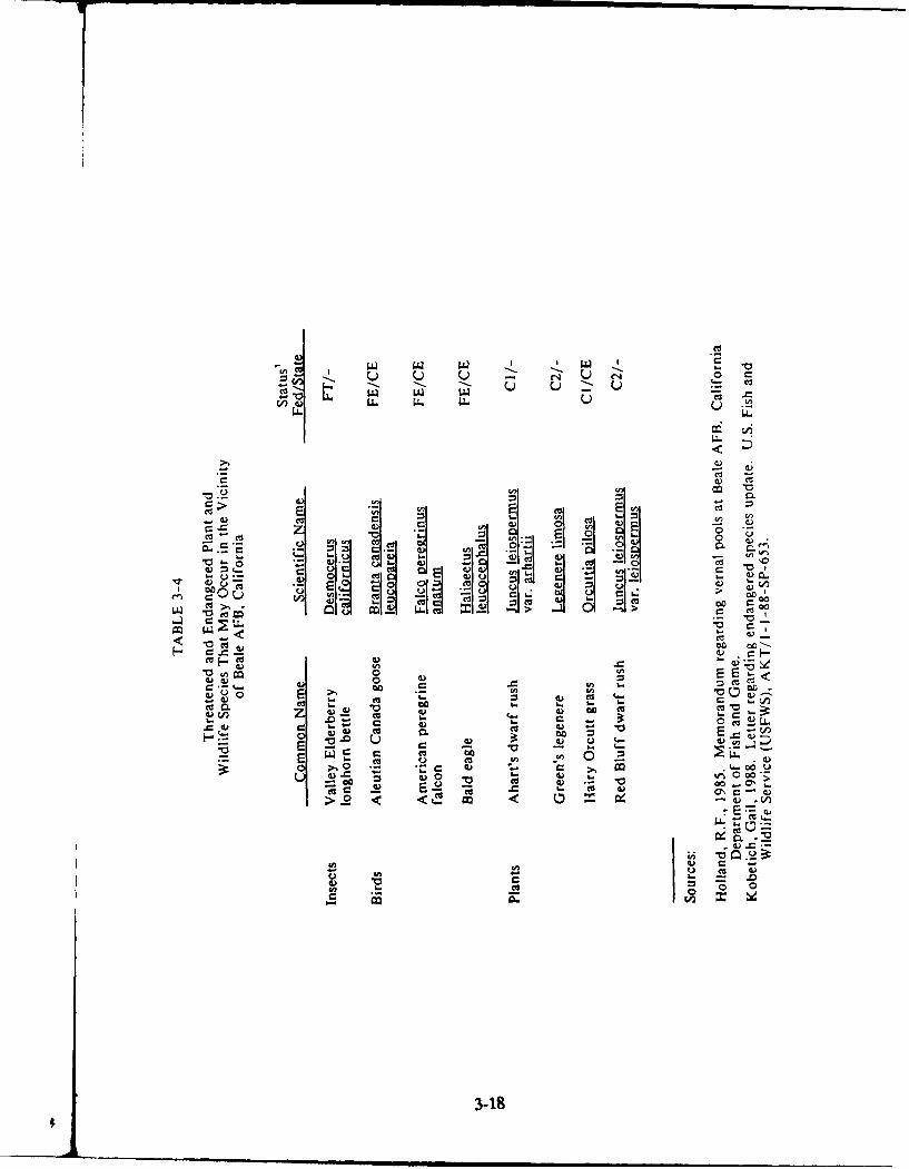
V0
u
m-
cd
.v of 0. 0
C%
E C cu
- I- .- .: w - . 000 to V00 2: &m <)
V)
3--18
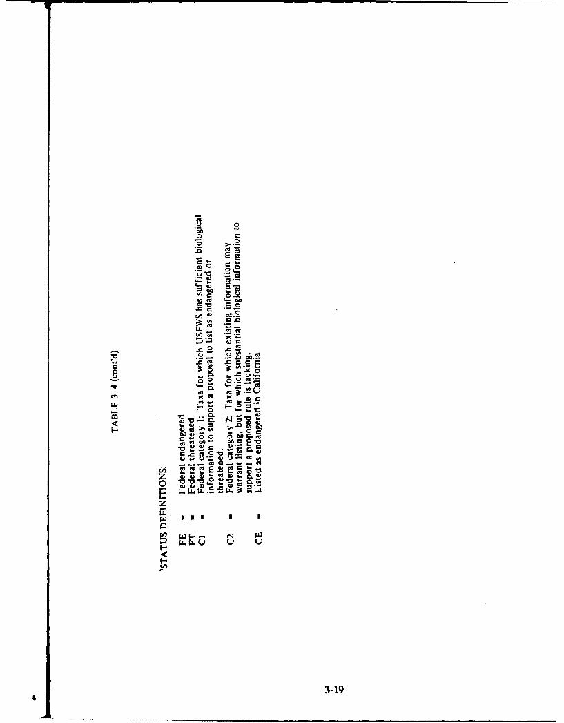
r &000
n g-c
CM1.- 0
Cu0 .0an0
0. -0 -V)0
mu Cu~
Cu. CU~.S
*~ .*3-19
for raptors. Beale AFB has an ongoing Bird Air Strike Hazard (BASH) program toalleviate the potential for large birds interfering with existing flight operations. Thisis of particular concern on base in areas west of the runway, where numerous vernalpools, portions of Rock Creek, and other small intermittent drainages have thepotential to provide habitat that can support seasonal and migrating bird populations.
Portions of Dry Creek/Best Slough in the vicinity of Beale AFB support aNovember and December king salmon run. Dry Creek is a perennial stream and iscapable of sustaining flows and adequate water quality to support upstream migrationof salmon during spawning periods. However, since flow volumes fluctuate with rainfallamounts, the quality of runs can be irregular. The last good run was in 1984 (PersonalCommunication, John Thomson, Beale AFB, October 1989).
The hilly, more heavily treed, and typically less populated areas in the easternportion of Beale AFB are used as a winter grazing range by migratory deer herds.The deer migrate from the lower portions of the Sierra Nevada Mountains in thewinter months to areas where grasses are more plentiful and weather less severe.During the hot, dry summer months, these deer herds migrate east to higher elevationswhere cooler, more suitable habitat exists.
3.5.2.2 Threatened. Endangered. and Sensitive Species
No animal or fish species listed as threatened or endangercd by the State orFederal government are expected to regularly utilize Beale AFB (PersonalCommunication, John Thomson, Beale AFB). Several Federally listed bird speciescould occur at Beale AFB as transients on rare occasions for brief periods of time,including the Aleutian Canada goose, peregrine falcon, and bald eagle (Table 3-4). Ithas been speculated that the endangered valley elderberry longhorn beetle could occuron the base; however, there are few elderberry trees present to provide suitable habitat.
3.6 ARCHAEOLOGICAL CULTURAL AND HISTORICAL RESOURCES
Although Euroamericans may have visited the Beale AFB vicinity as early as1808, it was not until 1841 that the history of the area was first recorded. Thediscovery of gold in California in the late 1840s had miners, merchants, and settlersmoving into the Yuba and Bear Rivers region, spurring the growth of mining camps,towns, and settlements. Two settlements, Marysville and Cabbage Patch (renamedWaldo), emerged in the early 1850s on the western and eastern edges of the present-day base boundary. Marysville was developed at the navigation head of the FeatherRiver and as the supply center for the northern mines.
Agriculture and cattle ranching were also influenced by the discovery of gold.Grains, particularly wheat, were grown throughout the Central Valley and the Bealearea supported a diversity of produce. Agriculture continued until the U.S.Government condemned 86,000 acres from 150 landowners and created Camp Bealein 1942.
Only small portions of Beale AFB have been intensely surveyed to determinepotential archaeological or cultural resources present on base. These include: 1) an
3-20
extensive survey of a portion of the Dry Creek drainage system in 1960-61 (Miller,1961); 2) a proposed irrigation project traversing the base in a narrow north-southcorridor surveyed in 1981 for the Yuba County Water Agency (Peak, 1981); 3) surveysconducted in 1982 by archaeologists from the U.S. Army Corps of Engineers inanticipation of proposed barracks construction in the cantonment area (Johnson andKenton, 1982); 4) surveys performed by Peak and Associates in 1983 for portions of theReeds Creek drainage and a proposed realignment to the west of the existing channel;5) large portions of the extreme southern portions of the base surveyed in 1987 (Raven,1987); and 6) ongoing surveys associated with the potential construction of a rail spurthrough a portion of the north-central area of the base (PAR & Associates, inprogress).
To date, a total of 22 archaeological sites has been recorded on the base. Ofthese 22 recorded sites, nine are prehistoric, eight relate to historic domestic activities,three are bridges, one relates to mining, and one relates to military activities. Most ofthe sites are discussed in detail by Raven (1987). Several additional sites have beenidentified by a privately funded study (Maniery, 1989). Table B-1 in Appendix Bsurrimarizes the known archaeological sites on the base and indicates whether they fallwithin the area of potential effect of the present project. This table indicates that twosites on the base have been determined eligible for the National Register, two siteshave been recommended as eligible, six sites have been recommended as not eligible,and twelve sites are of undetermined eligibility. Appcndix B includes a discussion ofthe two sites eligible for listing on the National Register.
In addition to the archaeological sites, 108 historic locations on the base havebeen identified through archival research. Most of these are (or were) structures, butroads, trails, mining ditches, and a cemetery are also identified. Table B-2 in AppendixB summarizes these historic locations.
Archaeological sensitivity for the base has been presented by Raven (1987).This sensitivity analysis provides information on the potential occurrence ofarchaeological sites on the base that have never been surveyed by an archaeologist.For prehistoric resources, five zones were identified-each zone is expected to containcertain types and densities of resources based on previous surveys near the base.Sensitivity for historic resources was based on historic documents and is discussedabove.
The sensitivity zones for prehistoric resources (Figure B-i in Appendix B) weredelineated on the basis of physiographic characteristics believed to influence prehistoricactivities and, in turn, the occurrence of certain types of remains. Descriptions of thezones also appear in Appendix B.
3.7 NI
Aircraft operations at Beale AFB produce noise, which results in both directeffects (annoyance, health effects, and impact on domestic animals) and indirect effects(land use) to the surrounding community. Ground noise levels generated by aircraftactivity at Beale AFB are estimated using the NOISEMAP computer program(Beckmann and Seidman, 1978). NOISEMAP results are expressed in terms of
3-21
average day/night sound levels (L,) using decibels (dB) on an A-weighted scale asunits. The A-scale gives a good approximation of the human ear's response to noiseand also correlates well with a person's judgement of the loudness of a noise event(EPA, 1974). 1, values are used by the Environmental Protection Agency (EPA), U.S.Department of Housing and Urban Development (HUD), and the DOD to describenoise exposure. In calculating 4, levels, noises that occur between 2200 hours and0700 hours are penalized by adding 10 dB to their actual noise levels. This penaltyaccounts for the fact that noises occurring at night are usually judged to be moreannoying than those occurring during the day. A more detailed description of the noisemetrics used in this analysis is given in Appendix C.
The noise levels estimated by NOISEMAP are based on me flight parametersof the aircraft, including the engine type, altitude, and throttle setting, and on theaircraft type, flight path, and profile utilization. These input data were gathered in1989. The data were in turn entered into a central computer at the Air ForceEngineering Services Center at Tyndale AFB, Florida. The NOISEMAP programcalculates 1 , values in decibels and plots a map of the noise "footprints" or contours.Noise contours are plotted with a minimum 4,, value of 65 dB because studies havedetermined that the percentage of persons highly annoyed by noise exposure increasesrapidly above this level. Also, HUD has adopted a L, value of 65 dB as the upperlimit of acceptable noise for residential development and the FAA uses a I, value of65 dB to define residential noise impact areas around airports. Documentation on theNOISEMAP program is located in Appendix C.
3.7.1 Existing Noise Conditions
Noise contours for Beale AFB are based on the average busy day, existing andplanned future peacetime levels of activity and the assumption that future militaryaircraft will not be noisier than existing military aircraft. Figure 3-5 presents L, noisecontours at Beale AFB under current operations. The noise contours shown in Figure3-5 take into account the recent deactivation of the SR-71 program at the base.
Noise complaints received by Beale AFB in 1988 were overwhelmingly attributedto sonic booms caused by SR-71 aircraft. It was estimated that 95 percent of the 217complaints in that year were of noise related to that aircraft. (USAF, HQ SAC, 1990).
Air traffic patterns for Beale AFB are established according to Air Forcedirectives, with safety and noise abatement considerations foremost. When flightsover populated areas cannot be avoided, procedures are established to minimize theinconvenience to those living in the affected areas. Prevailing winds are from thesouth about 90 percent of the time; thus, the majority of takeoffs are toward the south.The majority of the flying activity takes place west of the airfield and is regulated toa southeasterly flow. This means that most takeoffs are toward sparsely populatedrural areas in Yuba and Placer Counties. The northern patterns also fly over sparselypopulated areas.
Flying operations at Beale AFB are evaluated continuously to maintain noiselevels at a minimum. Practice takeoffs and landings and instrument approaches arenormally conducted at times when people are not sleeping, and usually are not
3-22

NLXY
.,//,.. . .-- 0
NOS COTOR (Ld' 3-23
t\ L
I 'd
FIGURE 3.5NOISE CONTOURS (Ld 11)
3-23

scheduled between 2200 and 0600 hours. During evening hours, only mission-essentialaircraft arrivwls and departures occur. Also, traffic patterns are located away frompopulation centers, and normal runup activities are not performed after 2200 hours orbefore 0600 hours. Engine runup locations have been established in areas ofminimized noise exposure for people on the base, as well as those in the surroundingcommunity. Blast deflectors are used to reduce noise where the runup blast is directedtoward the base boundary. Normal base operations do not include nighttime runups,but heavy workloads or unforeseen contingencies sometimes require a limited numberof nighttime engine runups.
3.8 LAND USES
Beale AFB is located entirely within the boundaries of Yuba County.Approximately 74 percent of the land area in the county is dedicated to farming andgrazing (EDAW, 1988; Cal DOF, 1988). The land bordering the base is primarilyagricultural. A Comprehensive Land Use Plan (CLUP) for Beale AFB was preparedby the Sacramento Area Council of Governments (SACOG, 1987), acting as theregional Airport Land Use Commission under authority of the Airport Land UseCommission Law (Article 3.5, California Public Utilities Code). The CLUPcharacterizes the existing land uses around the base as mostly agricultural landssupporting irrigated crops, such as rice, alfalfa, safflower, and corn; and deciduous treesthat produce peaches, prunes, and almonds, or rural residential mixed with open spacerecreation areas. In addition to adjacent agricultural lands, extractive mineraloperations occur to the north of the base adjacent to the Yuba River in an area knownas the Yuba Gold Fields.
SACOG considers the existing land uses around the base to be consistent withthe CLUP, which is based on flight safety, ground safety, and noise criteria. The planwas prepared to protect Beale AFB from incompatible uses of neighboring land;provide for the orderly growth of the area surrounding the base; safeguard the generalwelfare of the inhabitants within the vicinity of the airport and the general publicagainst adverse effects of aircraft noise; reduce the number of people exposed toairport related hazards; and ensure that no structures affect navigable air space.Planned land uses in the vicinity of the base, as described in the Yuba County GeneralPlan, are characterized as being generally consistent with the CLUP.
The maximum exterior noise exposure of noise-sensitive land uses should n( texceed an 1, level of 65 dB under the noise criteria contained in the CLUP. A rang.of acceptable noise levels for land uses that are not noise-sensitive has also beenestablished. Appendix C provides more detail on noise.
3.8.1 Accident Potential
The base has one runway, which is 12,000 feet long and 300 feet wide. Thereare asphalt overruns of 1,000 feet on the south and 2,250 feet on the north. Therunway is capable of handling any aircraft in the Air Force inventory.
The Air Force maintains 3,000-foot by 3,000-foot Clear Zones (CZ) at each endof the runway because of the high accident potential in these areas. Within the CZ,
3-24

land use restrictions prohibit economic use of the land. Accident Potential Zones(APZ) are less critical than the CZ, but still possess potential for accidents. APZ I are3,000 feet by 5,000 feet areas adjacent to the Clear Zones. APZ II are 3,000 by 7,GOOfeet areas adjacent to APZ I. These three zones (CZ, APZ I, and APZ 11) combineto form an area that extends to 15,000 feet from the runway threshold.
The Air Force controls activity in the Clear Zones. Through the Air InstallationCompatible Use Zone (AICUZ) program, the Air Force provides guidelines oncompatible land use within APZs to local agencies. (USAF, 1984). A 1,000-foot SafetyZone on each side of the runway center line, a 200-foot Safety Zone from the centerof each taxiway, and a 125-foot minimum Safety Zone from outside the aprons are alsomaintained. No incompatible land use is reported within the CZ, APZ I, or APZ IIat Beale AFB (USAF, 1984).
3.8.2 Height and Obstruction Criteria
In addition to accident potential and noise, the AICUZ plan also addressesheight and obstruction criteria for areas in the vicinity of airfields. These criteria,established by the USAF and FAA, are concerned with the following land useactivities: release into the air of any substances that would impair visibility orotherwise interfere with pilot vision; production of electrical emissions that wouldinterfere with aircraft communication and navigation systems; attraction of birds orwaterfowl; and placement of any type of natural or artificial object at a location andheight that would interfere with approaches and departures of aircraft. The State ofCalifornia prohibits construction of any structure that constitutes a hazard to airnavigation (unless the California Department of Transportation issues a permit). Theseobstruction criteria have also been incorporated into the zoning laws of Yuba County.
3.9 TRANSPORTATION
In December 1987, a traffic study of Beale AFB was conducted as part of aneffort to revise the Base Comprehensive Plan. Most of the quantifiable informationabout transportation conditions on and around the base is drawn from this study and,therefore, reflects specific conditions in December 1987.
3.9.1 Acces
There are five gates providing access to Beale AFB--the Main Gate on the west,Doolittle and Grass Valley Gates on the north, and Wheatland and Vasser Gates onthe south. Travel to and from the base occurs on a combination of State highways andcounty roads, including State Highways 65 and 70, State Route 20, North Beale Road,South Beale Road, Marysville Smartsville Road, and Spencerville Road. The locationsof the gates and roads are indicated on Figure 3-6. The relatively low traffic volumeson all except North Beale Road make it difficult for the access routes to become highpriorities for upgrading by the county. Daily traffic counts on or adjacent to the accessroads range from 850 on South Beale to 6,150 on North Beale Road.
t 3-25

0 1 2Miles
APPROXIMATE SCALE
SMIARTSVILLE
MARYSVILLEs
VASATEAT
WEATLAND TLAD
0 1870
LEGEND:0 CommunityT Beale AFB Boundary
0 Gate Locations
SOURCE. EDAW 1988 ~\ Average DailyTraffic Count
FIGURE 3-6BASE ACCESS
3-26
Traffic counts at each gate during morning and afternoon peak periods arepresented in Table 3-5. The Main and Doolittle Gates are the busiest while the GrassValley Gate is the least busy during these peak periods. Doolittle Gate has the highestpeak hour traffic (520 vehicles) and the highest 15-minute inbound traffic flow observed(192 vehicles). Backups of traffic occur there due to uneven distribution of arrivalsand security checks of some cars.
Vehicle traffic to and from the base is generated by five major user groups: (1)military personnel residing off base; (2) civilian employees working on base; (3) retiredmilitary personnel; (4) commercial traffic; and (5) visitors. Visitors generally use theMain Gate since it is always open and is the closest gate to the major urban center inthe area. Commercial truck traffic generally arrives from the south and favors eitherWheatland or Main Gates. Military personnel residing off-base, civilian employees,and military retirees use all of the gates. Their choice depends on their off-baselocation and on-base destination.
3.9.2 On-Base Roads
The road system on the base consists entirely of two-lane roadways. Capacityproblems can result at intersections where significant left-turn movements occur oneither minor or major streets. No left-turn lanes have been created to reduce suchdelays. At four locations, an auxiliary lane has been added on the outside of theroadway to enable through-traffic to maneuver to the right and pass traffic waiting toturn left. They are located on Gavin Mandery at intersections with A, C, and J Streets,and on Warren Shingle at the hospital entrance.
The ability of a road system to accommodate traffic demand in built-up areastypically is governed by the capacity of its intersections. Traffic exceeds intersectioncapacity on at least one approach per day at six intersections. All instances of capacityexceedance are for left turns or for through-movement on minor streets.
Four major base parking lots were analyzed as input to the development of theBase Comprehensive Plan (EDAW, 1988); two in the cantonment area (theCommissary and Base Exchange lots), and two in the flightline area on either side ofDouglas Road (Douglas Road north and south). Table 3-6 presents information on theuse of these lots. Based on the information in this table, the Douglas Road southernlot is slightly over capacity in the morning, apparently due to user preference for thislot over the northern lot. Other than this, adequate parking exists in these two areasof the base.
3.9.3 Bus .ngr.tion
The base operates a shuttle bus from 0600 to 1700 hours for the primarypurpose of providing transportation to work locations for military personnel withoutpersonal transportation. Military dependents are able to ride on a space-availablebasis. The local public transit system, Hub Area Transit System, operates a routebetween Beale AFB and Marysville during the summer to serve an employmenttraining program. Bus occupancy on this route was not great enough to justifyyear-round service.
3-27

.q... � C. -
0-
o §
C -
�o o� o�
o-�
LL. 0 ,-o O'C0'�� C.o.-
4) CI C
C's 04)
V�I 04) C
W E C-IC -�-� � 0
00'--C-,*0C
I- -. -� C
I-I-C'sI-
f-I
.1 8-C
8� we �
C
U E
'I
* ;�3.MiI� I-
a* U
I�I�
! tiC C� 2 � 0- � �
�-. .�
_ *�E� �g>'� MF>�� Wa
* .- 0� � * **��v.C I-.
I
3-28

TABLE 3-6
Utilization of Major Base Parking Lots
Available Weekday Spaces PercentLot Spaces Time Filled Filled
Commissary 225 1100 187 831700 152 68
Base Exchange 272 1100 152 561700 43 16
Douglas Road North 318 1000 151 481400 132 42
Douglas Road South 276 1000 280 1011400 237 86
TOTAL 1091 Morning 770 71Afternoon 564 52
Source: EDAW 1988.Note: Data collected in December 1987.
3-29

3.9.4 Railroad
The base railroad service, an extension of commercial tracks, enters the base onthe east side of South Beale Road and terminates in a switching yard east of J Streetbetween 6th Street (Gavin Mandery) and 14th Street (Warren Shingle). The service'sprimary function is to transport aviation fuel to the storage tanks located in this area,but occasional munitions shipments are also handled. Fuel deliveries are made threedays a week. A minimum of eight locomotive trips across Gavin Mandery are requiredfor each fuel delivery. For large deliveries, an additional eight locomotive movementsare required.
3.10 UTILITIES
3.10.1 Electric SuppLy
Electric service is provided to Beale AFB at 60 kilovolts (kV) from the WesternArea Power Administration and transmitted from their facilities over Pacific Gas &Electric (PG&E) lines to Grass Valley Substation. The base then distributes 60 kV toa number of substations on base where the voltage is stepped down to 12 kV anddistributed. The electrical system is considered extremely reliable, with only one to twoshort duration outages per year (PAT, 1989).
3.10.2 Water SuIDDI
The water distribution system at Beale AFB originates at the wellfield locatedon base approximately 1 mile east of the Main Gate (Figure 3-7). The field iscomposed of eight active wells whose collective capacities are 7,750 gallons per minute(gpm) or 11.16 million gallons per day (mgd) (EDAW, 1988). Water from the wellsis treated at the adjacent water treatment plant and then pumped through an 18-inchtransmission line to the main line booster station south of the flightline area. Thistransmission line is an approximately 50-year old spiral well casing, and is sufferingcorrosion failure. It will be programmed for replacement. From the main boosterstation, water is pumped to a 250,000-gallon elevated storage tank located near theflightline area, and to the 3,000,000-gallon main storage reservoir northeast of thecantonment area that feeds three other separate storage facilities. Total water storagecapacity for the base is 5.2 million gallons.
The water supply is adequate to meet present and future needs; however, thewater treatment and distribution system will need some improvement (PAT, 1989).Current groundwater usage at Beale AFB varies from 2.5 mgd in the winter to 6.0mgd in the summer; the large variation in usage is due to high irrigation demand in thedry months. These usage figures are assuming an average daily base population ofapproximately 10,000 people, including military personnel, dependents, civilian workers,base contract personnel, retired personnel taking advantage of base facilities, and othervisitors (Personal Communication, Mr. Tony Guerrero, Manager, Water Treatment andWater Supply, Beale, AFB, 1989).
The water supply to the housing area is adequate to meet substantial growth, butadditional delivery demands will probably require additional and backup booster
3-30
I..
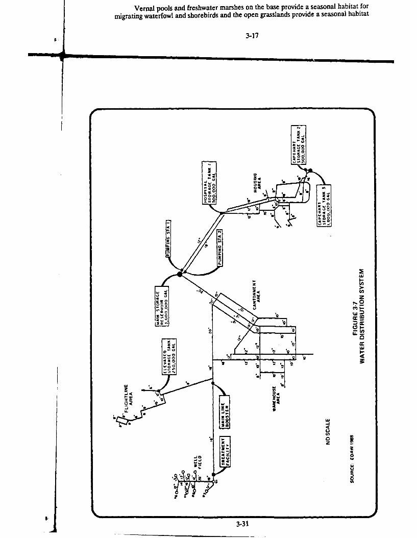
Vernal pools and freshwater marshes on the base provide a seasonal habitat formigrating waterfowl and shorebirds and the open grasslands provide a seasonal habitat
3-17
= . ,. .
0-9 -
[7,;M2z
IL%
C,'
CL X,
UAMcr
MccLL
3-31

pumps. The water supply and delivery system in the cantonment area is adequate tomeet present and future needs. The water supply to the flightline area is alsoadequate.
The water treatment includes injection of chlorine and fluoride. The water isnot filtered at the treatment plant, although some wells are equipped with sandseparators. The water treatment plant treats approximately 2 mgd during the wintermonths and up to 6.5 mgd in the summer months. The estimated capacity of the plantis 7 mgd. There is no treatment for manganese levels (see Section 3.4.3.1). In additionto the distribution system on base, reclaimed water from the wastewater treatmentplant is pumped to the golf course for irrigation through a separate water line.
3.10.3 Communication
Commercial communications services are provided to the base by Pacific Belland the American Telephone and Telegraph Company. The existing basecommunication system is at absolute maximum capacity and the 1883rd CommunicationSquadron is presently evaluating proposals for completely replacing the existing systemwith a new Base Information Digital Distribution System (BIDDS). The BIDDS willinclude a fiber optic cable system and a digital switch that will support a completestate-of-the-art communications system and will ultimately allow complete computernetworking. The BIDDS will ultimately have the capacity to serve the present baseload, the relocated SUNT load, and have spare capacity for 5 to 10 years projectedgrowth. The new BIDDS will be government-owned, contractor installed andcontractor maintained (PAT, 1989). It is anticipated that the BIDDS System will beinstalled and operational prior to the end of FY 1993 when the SUNT becomes fullyoperational at Beale AFB.
3.11 WASTE MANAGEMENT
3.11.1 Solid Waste Disposal
Solid waste from base operations and households is disposed of in a sanitarylandfill located on the southern portion of the base, between the cantonment area andthe family housing area. Vehicles enter the landfill from Gavin Mandery Road. Thislandfill, occupying about 40 acres, has been in use since 1981, and is permitted by theState as a Class m (nonhazardous) landfill. The landfill has an estimated totalcapacity of approximately 3,795,000 cubic yards (cy), of which approximately 845,000cy are used. The current usage rate is approximately 5,219 cy per month or 62,628 cyper year. At this current rate of use, the landfill has an estimated remaining lifetimeof 35 to 40 years (Personal Communication, Mr. Greg Miller, Beale AFB, September,1989).
Waste deposited there is primarily general refuse. Landfill operations consistof trench method disposal, and water runon and runoff controls are present.Management practices include no chemical disposal and daily coverage of the waste.A landfill study has been accomplished under the Installation Restoration Program thatcomplied with the California Solid Waste Assessment test. The results of this study
3-32

indicate that no groundwater contamination or contaminated leachate emanated from
the landfill (Aerovironment, 1987).
3.11.2 Wastewater Disposal
The sanitary sewer system at Beale AFB is primarily a gravity flow system.However, two iift stations are required to pump flightline wastewater up a slight gradeto the STP located in the southwestern portion of the base. The STP is designed totreat 5.0 mgd, and currently receives an average of approximately 1.0 mgd.
The sanitary sewer system services the three main areas of the base, the familyhousing area (including the Hospital and PAVE PAWS), the cantonment area, and theflightline area. Approximately 97 percent of the flow entering the STP originate fromthese areas. The remaining 3 percent of the flow is from the Precision Photo Lab.
Precision Photo Lab wastes are collected in a wet well and pumped through anunderground line to the photo wastewater treatment plant. Discharge from thispretreatment system combines with sanitary sewage prior to entering the STP.
A cease-and-desist order was issued by the CRWQCB because dischargelimitations stated by the NPDES permit were being exceeded. There were high levelsof boron and cyanide in the effluent along with a foaming problem upon discharge toHutchinson Creek. The boron and cyanide come primarily from the Precision PhotoLab wastewater that enters the sewage treatment facility. To correct these problems,an evaporation unit has been installed at the photo lab that pretreats the chemicalsolutions used in developing film prior to its entering the photo wastewater treatmentplant. It handles approximately 700 gallons per day. The evaporation unit reduces theamount of sludge entering the photo wastewater treatment plant from the filmdeveloping process. This sludge is placed directly in barrels at the photo lab anddisposed of in accordance with hazardous waste regulations. Approximately 3 to 5barrels (55 gallons each) of sludge were generated each month prior to installation ofthe evaporation unit. The photo washwater, approximately 20,000 to 25,000 gallons perday, is discharged directly into the photo wastewater treatment plant.
Primary and secondary treatment at the STP includes a grit chamber, twoclarifiers, two trickling filters, two anaerobic digestors, one chlorine contact chamberand an aeration pond. The effluent from the STP normally enters Hutchinson Creekin accordance with a NPDES permit issued by the CRWQCB (permit No. CA0110299).However, during times of low flow in the creek, a major portion of the treatment planteffluent is diverted to the golf course equalization pond where it is used for irrigation.Non-hazardous solids from the anaerobic digestors are taken to the base landfill fordisposal.
3.11.3 Hazardous Waste Generation and Disosal
Beale AFB has five accumulation areas for containerized hazardous wastes. Sitemanagers have the responsibility of maintaining and inspecting the accumulation sitesand the generation sites. These managers generally transport wastes from thegeneration points to the accumulation sites on a weekly basis. All waste oils and fluids
3-33
5 ________I_____________________
are either placed into drums or directly into aboveground or underground storagetanks. All waste oils are then sold to a local waste oil contractor. Drummed wastesare transported to the Central Storage Facility prior to removal by the DefenseReutilization and Marketing Office at McClellan AFB, California. Beale AFB isrequired to report generation totals to the Region IX office of the U.S. EnvironmentalProtection Agency and the State of California Department of Health Services bienniallyfor the preceding calendar year. The base is also required to report hazardous wastemanagement spending to HQ SAC each fiscal year. All of these reports are sourcesof information for types and quantities of hazardous wastes generated by baseoperations. Annual forecasted quantities of wastes generated at Beale AFB arepresented in Table 3-7 by category.
3.11.4 Beale AFB Installation Restoration Program
The Installation Restoration Program (IRP) is a product of DOD policy. Thispolicy, directed by Defense Environment Quality Program Policy Memorandum 81-5,has three objectives. The first is to identify and fully evaluate suspected problemsassociated with past hazardous material disposal sites on DOD facilities; second, tocontrol the migration of hazardous contamination from such facilities; and third, tocontrol hazards to health and welfare that may have resulted from these pastoperations. The legal mandate for the USAF IRP is the ComprehensiveEnvironmental Response Compensation and liability Act (CERCLA or Superfund)and the Superfund Amendments and Reauthorization Act (SARA).
The WRP is a three-phase program designed to ensure that identification,confirmation and quantification, and remedial actions are performed in a timely andcost-effective manner. The phases are as follows:
* Preliminary Assessment/Site Inspection.* Remedial Investigation/Feasibility Study.* Remedial Design/Remedial Action.
Beale AFB currently has 24 IRP sites. Figure 3-8 shows the general location ofthese sites. The sites include four landfills, three fuel spill areas, two abovegroundfuel storage areas, two sites associated with photographic wastewater treatment, twoengine test cells, two pesticide/herbicide buildings, one fire training area, and eightother sites of various types. One of these miscellaneous sites is actually a wide areaof the base where over 750 abandoned underground storage tanks are suspected.Table 3-8 lists the 24 IRP sites, a brief description of each site, and the waste typessuspected for each site. None of these sites nor any other portion of Beale AFB hasbeen listed or proposed for listing on the National Priorities List (40 CFR 300Appendix B and Federal Register Vol. 54 and 55).
A major field investigation of all 24 sites was recently completed. This work andan earlier study represent the bulk of the remedial investigation activities that areexpected to occur on the base. No further action is recommended at five sites at thistime. Additional investigation will be required at a dozen sites and monitoring ofconditions will continue at 15 sites. Five sites are ready for feasibility studies and seven
3-34
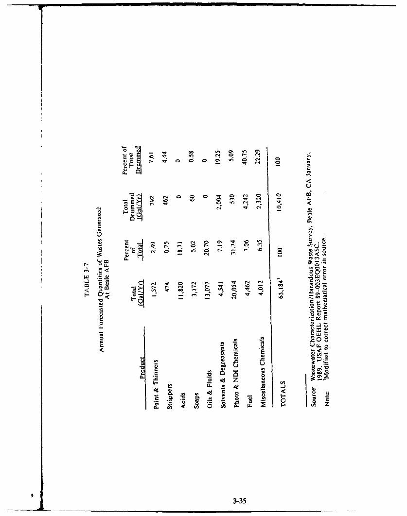
C> C4
U
C4 C- 4 0 0D 0 -, 0ý eD 0C6III 0 n IT f
0 0 C) '0 0n C; r ' r
Cu>
4)y 0
CuC4
Cu~~~~c Lo 0400I&0N-N%
cuu
to v
Cu:
06V 01~4) ~4FC
< o if
3-35-

z
CL
w z M5
.4W <
>) Q
a:z0 f
I-K
Cl)L
zI >
D <~
w IU ID
00 0z (n 6Iz~.'---1 I
3.36 L
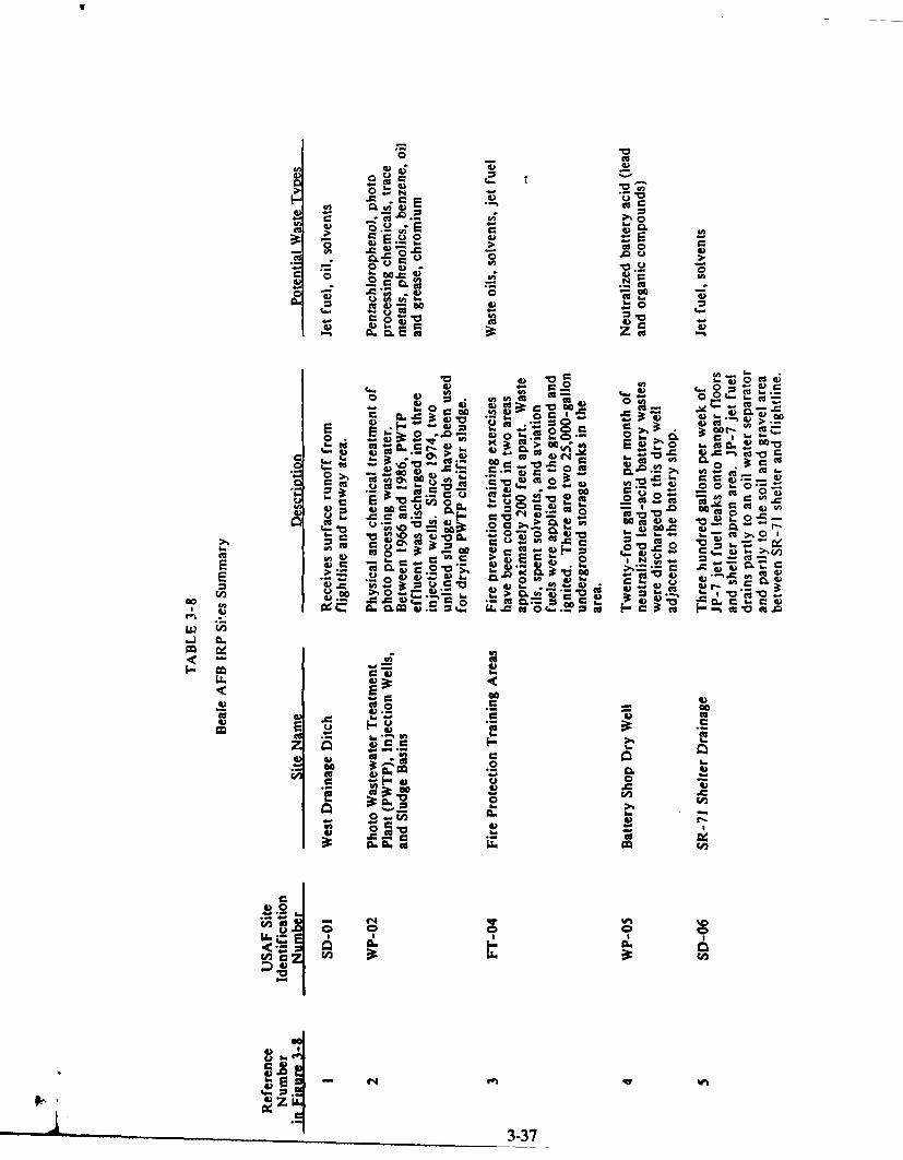
UU
Bt: -C o
C) Cu&.
0620
*0 CA F I tGo CAa)-a
4) 0
CD .0 ( 4)4) a0 4). Cu0 0
)u
C 6 10 cuC 0CL 4
> go -0 C= 4) C.cc.4
Co- . -i 06 .C r-1
06 P"u0 Gn- CC
2 t (A 42 V) r.- 4) cco . l - 'a - 4)0 2 .. U -
cis C> ca 0 0
E. .0. .- 0 Cu ft- Q3 Cc Cu 0e . 0 ~**CEn .. O ..0 i4)(8 4 .. U-C
0) Go~u c b U 06)~ W CI o(4 0 4)cc
C C. c M)~ 4)0" c
cqs~C 0
-U. 0 Q2C go0 ~ -00bS Cu3
%0A C o u.0 4) 0. 00' W -Ca
~~aa ~ 0 964*~* ~ ~ ~ .
4) 0 E £.A4C...( I-- CuC Fu)C
I" C- CO~ 06.
Cu CU. A .CuC
.2.tv *Cucc
Do 0 -6
U2 C
CaC
*05
o 0
oi.l.. I.
3-3
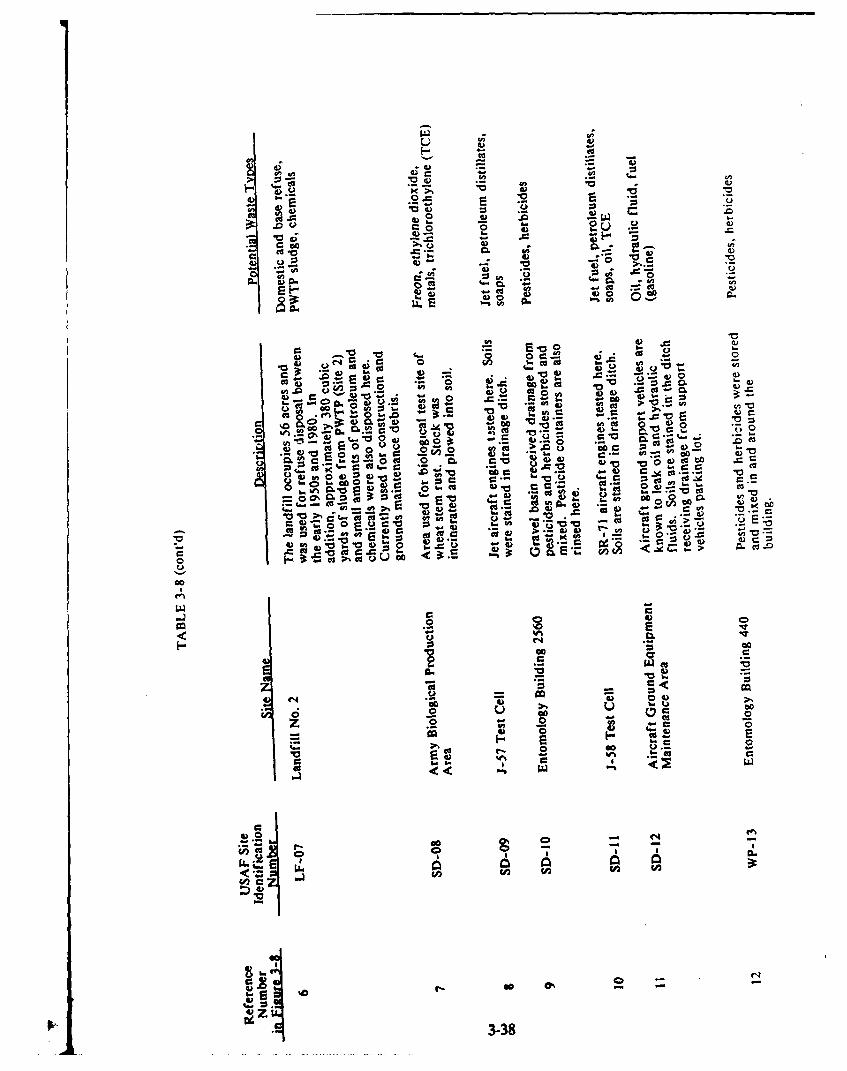
0 C6
e~o .rF..9 ,••eto•' - ' - -
S -) N.- 4n
.- , § v4 .
C> M
(A .o 0 UU 2e 4 0
001 *04 -wC
00 ou . 4)E~
0%ot
" 0 . - Q 0 4)E06r
"to .Uo - = to
0)0
" "4 _- C CA 4
'7 .6 4 --
~~..-.'.c V) C.. '
b. S 0 0 0
• -e ,
05l0 ý VV &1) 6 go~4)4 0Au
.* = ' 0 C; 06~ E ;~
0 -E
V ..- V
C4 0 V
~~ G C uC c
4) 0
EE0 d 0.o
V CL
3 -3

.0*0Z 06
4) 4 )3
c *0
0. 0 4) 0o Do
00.2- ccou 4). AL 44) 06
cU 4) = 6.0DE c4)E 00 ..- 4o 4)i2 b. $. )alc v1. ) 0.-
3:s 0.- 0. - a - 00 S0 0o ca 0 tot
C6 as 4) 4) bC 0r0 ba ý: 04 U0 IT.I -.c> n , Vci 0- w V) -- z -. 0
0- 0 OD CA)A" '00. 00
w Cl t-.0 0 0 - r1.0 to 6. 4 cc. -0:2C60 4n 0 04)4 - 0: 0 . L 4) 00
%)o 0 E 0 "aca.. r- 0. ci , 4) W
a0 0
t. o *V-)C = -
v >%) *.C 0 4)>
C 10 cc v4) a)~.. V~ w Cc "a ~0)4) .0 02 0 a.'a 3: 20. cc ii
~c 004) cc ~co S ... 4 0 00~0
*~04)~n 0 .02 .
CO U.4cc
0*
La x _ 5
LL, C4.
CA 0
C4 CI
03-39

.0
CD
G,
0
.A k..
06 00 06 0
L. ca
Z 06
0 to.00 4) 0a
U, - V C
co0U,
- &-
0 cc
soonU,)
0 .0
4C4
.0.0.
.0i 05 0
3-4- a- 0

for risk assessments. After these additional investigations, studies, and assessmentsare completed remedial design and action can proceed.
3.11.5 Underground Storage Tanks
There were approximately 750 underground storage tanks that stored fuel oil andgasoline in the area of Beale AFB previously occupied by Camp Beale. It is not knownwhcthc" they were emptied or removed when the Army closed the camp. Camp Bealerecords suggest that these tanks were located within an area identified as Site 22 of theongoing IRP. This area is shown on Figure 3-8. A review of 1943 maps of CampBeale indicated that there were a total of 38 gasoline USTs with capacities between5,500 and 12,000 gallons, and 715 fuel oil USTs ranging in size between 265 and 12,000gallons.
Limited investigations to determine the presence of USTs have been conductedwithin the cantonment area affected by the construction of the Academic Complex.The results of the investigations indicated several magnetic anomalies that couldpossibly be USTs. However, ground truthing activities to confirm the results of theinvestigation will be conducted.
3.11.6 Abestos
Initial inspection of facilities on base for the presence of suspected asbestos-containing material has been performed, but no sampling survey to confirm thepresence of asbestos has been completed. A summary of available information onasbestos in buildings planned for demolition or renovation has been assembled fromthe base's asbestos registry and is presented in Table 3-9. Prior to demolition orrenovation activities, a survey will be conducted to confirm the presence or absence ofasbestos. If asbestos is present, appropriate remedial actions will be implemented.
3.12 SOCIOECONOMIC FACTORS
Socioeconomic factors are described in a geographical context comprisingprimarily Yuba County, but also taking account of the surrounding region, asappropriate. Many of the military and civilian personnel of Beale AFB reside off basein Yuba, as well as in the neighboring counties of Sutter, Butte, Nevada, and Placer.A few reside as far away as Sacramento and its suburbs. The buying power of thepersonnel employed at Beale AFB is a major factor in the region's economic health.
3.12.1 Demogiazhics
Population estimates for Yuba and Sutter Counties are presented in Table 3-10.Yuba County has experienced a modest growth trend of between 1.7 percent and 2percent per year since 1950. The Yuba and Sutter County population is projected togrow less rapidly (1.4 percent annually) than the State as a whole over the next severalyears.
"3-41

0
c
r -Cc c
is ~
c ~ 0a
c0 . . a a aa2, 0 .2 e a
aa
In I -a
A r DINz
44 0 0 M
0. 342

2 -
s - c- a .
E a a E~. E
z - :
a0 0
O~~~~ as a~~.
At a: z ~
Z a Z = ;~
E
3-43
- IC .2 ---

TABLE 3-10
Estimated Population of Communities Surrounding Beale AFB
Population
Yuba County 57,300
Marysville 11,850Wheatland 1,890Unincorporated Area 43,600
Sutter County 62,500
Yuba City 24,600Live Oak 4,100Unincorporated Areas 33,800
Total Yuba and Sutter 120,000Counties
Total Urban 42,500
Source: Cal DOF 1989.Note: Individual figures may not add to totals
because they have been rounded.
3-44
3.12.2 Economic Characteristics
Beale AFB lies in the Yuba City Metropolitan Statistical Area (MSA), which iscomposed of Yuba and Sutter Counties. The resident civilian labor force for YubaCity MSA was 44,700 in 1987, of which 39,450 people were employed, while 5,250 (11.7percent) were unemployed (Cal EDD, 1988). The average number of jobs providedby Yuba City MSA-based employers totaled 34,500 in 1987, indicating that severalthousand working residents of the region were employed away from the MSA. Thestructure of employment in the Yuba City MSA reflects a diversified economy restingon a strong base of agriculture, manufacturing, commerce, and government. Table 3-11provides the composition of wage and salary employment for the Yuba City MSA in1987.
The number of construction workers in the Yuba City MSA generally balancesthe demand for such skills, according to the California Employment DevelopmentDepartment (Cal EDD). During 1987, the number ranged between a wintertime lowof 1,575 and a summertime high of 1,925 (Cal EDD, 1989). Construction workers inthe area have remained a relatively constant percentage of the total labor force throughthe years, expanding with the overall growth of the area workforce (Cal EDD, 1988).The Sacramento Valley is an enormous labor market, and there is considerablemobility of workers responding to project opportunities throughout the region. Therapid growth of the valley and foothills communities has attracted large numbers ofskilled and unskilled workers; therefore, no problem has been experienced in securinglabor for construction projects.
The Cal EDD projects modest growth of employment in the Yuba City MSA.Between 1987 and 1989, Cal EDD estimated that the total number of jobs in theregion would increase by about 850, or about 2.5 percent. The retail trade sector wasexpected to experience the largest employment increase of any sector during this periodfollowed by the services and government sectors (Cal EDD, 1988). These projectionsdo not take into account possible USAF actions. Other central foothill counties andcounties around Sacramento are all projected to grow more rapidly than Yuba andSutter in the near future (CCSCE, 1988), implying greater employment opportunities.Similar projections hold for the growth of personal income in the area. Personalincome levels in the Yuba City MSA have been lower, on a per capita basis than thestatewide averages. In 1987, the per capita income for the MSA was $12,158,compared to the statewide average of $17,841. The statewide average breaks downinto a metropolitan portion average of $18,044 per capita, and a nonmetropolitan areaaverage of $13,299 per capita. On this latter basis, the Yuba City MSA's per capitaincome is close to the statewide nonmetropolitan area average (BEA, 1989).
The Beale AFB Annual Report FY 1988 Economic Resource Impact Statement(ERIS) indicates that the base had a total of 4,642 personnel directly connected withhost and tenant activities in FY 1988, of whom 4,142 were military personnel and 500were civilians. An additional 748 civilian and contractor personnel were employed inthe Base Exchange, private on-base business, and contractor assignments (Beale AFB9th SRW/ACC, 1988). The ERIS estimates for payroll and expenditures spent in a 50-mile radius Economic Impact Region (EIR) are presented in Table 3-12.
3-45

TABLE 3-11
Annual Average Civilian Wage and Salary EmploymentYuba City Metropolitan Statistical Area, 1987
(Yuba and Sutter Counties, CA)
Economic Sector Number of Jobs
Total agriculture, forestry, andfishing 5,200
Agriculture production 4,725
Agricultural services, forestry, 475ar I fishing
Total nonagricultural 29,300
Construction and mining 1,850
Manufacturing 3,200Food & Idndred products 1,100Lumber & wood products 1,Z25Other manufacturing 875
Transportation and public 1,275utilities
Wholesale trade 1,325
Retail trade 6,300
Finance, insurance, and real 1,425estate
Services 5,925
Government 8,025Federal 1,475State 850Local & education 5,700
Total employment 34,500
Source: Cal EDD, 1988.Note: Employment is reported by place of work. Individual job figuresmay not add to totals because they have been rounded.
3-46

0% Q% @ coo0 0 tnm~O
0f co ea
00 qNV l - 4-I
0000
mC 00 Nf -n O N Go
0 00- tn C-4 « < < <
E 000 4jU .<
-i .9 0
0 u~ 06 wi i. 0
U ~~ ccE E- w 'ago~ MJU4) ~
WC -0~ ~ U 3
000 0 0 LL47

As indicated in Table 3-11, the $102.97 million of direct Beale AFB-relatedspending within the 50-mile radius EIR for payroll, goods, and services generated acumulative economic impact of $258.65 million in 1988 (Beale AFB 9th SRW/ACC,1988). This implies that the base had a regional multiplier effect equivalent to 2.5times the value of direct base-related spending (a direct impact of $102.97 millionplus an indirect and induced effect of $155.68 million). The economic impact regionencompasses all of Yuba and Sutter Counties and portions of Butte, Sierra, Nevada,Placer, El Dorado, Sacramento, Yolo, and Colusa Counties. Secondary job creationdue to the infusion of new income generated an additional 1,732 jobs in the region,according to the ERIS. Secondary job creation is the additional employment createdwithin the 50-mile EIR in response to the multiplier effect of the base-relted demandfor construction, materials and equipment, and consumer goods. The level of demandis estimated in the ERIS based on levels of on-base construction activities, materialsand equipment requirements, and payroll expenditures.
3.12.3 Housing
The housing situation in Yuba and Sutter Counties is relatively soft, with newsingle family home starts having declined between 1987 and 1988. According to theYuba-Sutter Chamber of Commerce, the housing market is in equilibrium with thepresent supply of new homes equal to about 12 to 18 months of demand, at currentlevels. Rental vacancy rates in apartment complexes are running at 5 percent. (Yuba-Sutter CoC, 1989). New subdivision homes are being priced from $75,000 to $125,000.Developers and landlords are expecting that the closure of Mather AFB in Sacramentoand transfer of some units to Beale AFB will firm up the market, and some spilloverof housing demand from the Sacramento area is beginning to be experienced.According to the Base Housing Assistance Office, " the rentals in the Yuba City,Marysville area are generally within the price range of all the military assigned toBeale AFB." The average two bedroom apartment rents for $300-450 per month, anda three bedroom house rents for $495 and higher (Beale AFB 814th CSG/DEEV,November/December 1988).
Total housing in Yuba and Sutter Counties in 1987 amounted to 43,586 units,of which 28,478 (65 percent) were single family units, 9,920 were multiple family units(23 percent), and 5,188 (12 percent) were mobile home units (Yuba-Sutter CoC, 1989).The SACOG is projecting that by the year 2000, the housing stock in the two-countyarea will total 54,357 units, a 25 percent increase. This rate of growth is equivalent toan average annual compound rate of 1.71 percent, which is about the same as therecent trend of population growth in the area.
According to the Base Housing Assistance Office, military family housing atBeale AFB consists of 1,712 units (211 for officers and 1,501 for enlisted personnel),anc, typically there are about 200 families on the waiting list at any given time (BealeAFB 814th CSG/DEEV, November/December 1988). An estimated 606 Beale AFBfamilies are housed in private housing off base. In addition to family housing, ninedormitories provide space for 1,090 Airman and Non-Commissioned Officers (NCO)not accompanied by dependents. Temporary lodging arrangements at Beale AFBconsist of the following:
3-48

Visiting Airman Quarters 33 units 67 bedsVisiting Officer Quarters 37 units 37 bedsTemporary Lodging Facilities 24 units 66 beds
3.12.4 Education
Yuba and Sutter Counties have 41 elementary schools, five intermediateschools, ten high schools, 13 parochial/Christian schools, two special schools servingonly handicapped students, one regional occupational program, 23 preschools anddaycare centers, one community college, and three satellite colleges. Enrollment in thepublic elementary, intermediate, and high schools totaled 21,125 pupils in 1988--1,040in the parochial/Christian schools, 335 in the special education schools, and 10,193 inYuba Community College (Yuba-Sutter CoC, 1988).
Schools that educate dependents of Federally employed personnel are eligiblefor Federal Impact Aid Subsidies under Categories A and B. Category A funds applyto dependents who have a parent or parents who both live and work on base. CategoryB funds apply to dependents who have a parent or parents who work on base but liveoff base in housing that is not Federally subsidized. In FY 1987-88, Beale AFBeducation impact funds totaled $2,123,101, with an additional $301,000 being providedas tuition assistance for college-level student dependents (this money is included in theConstruction and Services Procurement component of Table 3-11; ERIS, 1989). Mostof the school impact assistance went to Yuba County schools. Federal funding of alltypes to Yuba County schools amounted to $5.75 million in FY 1987-88 (Davis, 1990),which represented about 12 percent of the system's total budget of $48.3 million. TheBeale AFB school impact funds therefore accounted for more than one-third of thecounty schools' Federal funds, and for about 4 percent of 'he schools' total funding.
Table 3-13 shows the distribution of Beale AFB students in Yuba and SutterCounties public schools, grades kindergarden through 12. Lone Tree (K-3) and FarWest (4-6) schools are located on Beale AFB on sites leased by the WheatlandElementary School District, but they operate independently of the base. All otherschools are off base. Smaller school districts, such as Camptonville and PlumasElementary in Yuba County and Live Oak Unified School District in Sutter County,had no students qualifying for impact assistance from Beale AFB (Personalcommunications, school districts, 1990).
The three satellite colleges are all housed at Beale AFB--Golden GateUniversity (of San Francisco), Chapman College, and University of Southern California.(Yuba-Sutter CoC, 1988). Education enrollment of base personnel totaled 2,191persons during FY 1987-88: 27 in technical courses, 1,929 in undergraduate courses,and 236 in graduate courses. (ERIS, 1988)
3.12.5 Community Service Facilities
On Beale AFB, the 9th Strategic Hospital serves on-base requirements. It hasa staff of 398 persons, of whom 362 are military and 36 are civilian employees
3-49

q2
4C
E
CC
CC06•
Cd
4))
l~C.
c
=< |
U •'
U -~
so)
f4)
S~3-50
. ... -... ..

(ERIS, 1988). Law enforcement is provided on base by the Security Police (9thSecurity Police Squadron), which has a total of 233 personnel (ERIS, 1988).
The Services Squadron (SV) of Beale AFB has the responsibility to provide forthe needs of base personnel (EDAW, 1988). Under this charter, SV operates fourfunctions: furnishings (such as linens, etc.); services (including the Base Exchange,which is managed by AAFES; the Base Commissary, which is managed by Air ForceCommissary Services; the mortuary; and the honor guard); billeting; and dining. TheCommissary provides troop issue support and subsistence support to authorizedpatrons-base personnel, dependents, and retired military personnel. The BaseExchange sells consumer goods at a main store, and provides other services at anumber of small shops, a laundromat, a snackbar, a barbershop, and service stations.These are located in the cantonment area of the base, which also includes a post office,a credit union, a bank, and a number of recreational and activity facilities (EDAW,1988).
The base's MWR organization (9 CSG/SS) provides a wide range of recreationaland personnel support programs, including athletic programs, bowling and golf facilities,the Recreation Center, arts and crafts, a youth activities program, chaplain services, aveterinarian, and a childcare center. MWR also operated the Officers and NCO OpenMesses, the Aero Club, and the base Rod and Gun Club (ERIS, 1988).
3-51
4.0 ENVIRONMENTAL CONSEQUENCES
This section provides a discussion of the environmental impacts associated withthe realignment of the 323rd FTW to Beale AFB; means to mitigate adverseenvironmental impacts; potential cumulative impacts; any adverse environmental effectsthat cannot be avoided; the relationship between short-term uses of the humanenvironment and the maintenance and enhancement of long-term productivity; and anyirreversible or irretrievable commitments of resources associated with implementationof the realignment. The concept of "significance" used in this document is defined inSection 1508.27 of the CEQ's regulations implementing NEPA, and includesconsideration for both context and intensity (or severity). In the discussions that follow,criteria used to distinguish between significant and insignificant impacts are provided.To the extent feasible, distinctions are also made between local and regionalsignificance, and short- versus long-term duration.
4.1 MISSION AND OPERATION
Implementation of the realignment would add a mission to Beale AFB andincrease its overall operation. The realignment would increase personnel byapproximately 1,602 (combined military, civilian, and student) and station 14 T-43 and22 T-37 aircraft at Beale AFB. The realignment would require that additional facilitiesbe constructed and/or modified in the flightline, cantonment, and family housing areason base. These facilities would be associated with a new academic complex, aircraftmaintenance complex, and base operating support facilities.
Aircraft operations at Beale AFB will be significantly increased as a result ofthe realignment. At Mather AFB, current SUNT flight activity consists of an averageof 49 T-43 operations and 183 T-37 operations per day. When these operations areadded to current Beale AFB flight activity, a maximum increase of approximately 34percent-from 668 operations to approximately 897 operations per day-may result. Anoperation consists of one takeoff, one landing, one low approach, or one touch andgo. In addition, the base population would increase by approximately 3,435 persons,including military personnel and dependents.
Increases in base personnel and overall base operation will help offset the recentforce structure drawdown of the SR-71 program, which will be completed by June 1990.This drawdown resulted in the loss of approximately 624 positions (both military andcivilian) on base, as well as a number of flight operations per day. The exact numberof daily operations associated with the SR-71 drawdown is classified.
4.2 GEOLOGY. TOPOGRAPHY
General geologic conditions are considered to be similar across the base.Because of this similarity, potential impacts and mitigation measures are also expectedto be similar, if not identical. For this reason, impacts and mitigation measures arediscussed together as a whole and are applicable to all areas of the base.
4-1

Earthquake-induced strong groundmotion. Beale AFB is situated in atectonically active region that can be expected to experience groundmotion within theforeseeable future. Strong groundmotion from earthquakes can damage structures orfacilities not specifically designed and constructed to withstand such motion. Impactsassociated with earthquake-induced strong groundmotion can be significant andadverse, but mitigable. However, based on the seismic history of the area and thefact that the nearest active fault is located approximately 25 miles from the base,impacts at Beale AFB are expected to be minimal.
Liquefaction. Settlement, and Expansive Soils. liquefaction can occur insaturated granular soils subjected to strong groundmotion and will cause loss of soilstrength so that structures will not be supported. The potential for liquefaction tooccur in areas where realignment activities will occur is expected to be low due to theabsence of significant saturated soils and because soils beneath the sites containsufficient clay materials to preclude susceptibility to liquefaction. Differentialsettlement or expansion of soils underlying buildings, roads, and other facilitiesassociated with the realignment may lead to damage of these structures. Damagetypically consists of cracks in slabs or plaster, but may lead to significant structuraldamage if the settlement/expansion is extreme. However, because site-specificgeotechnical investigations have not been conducted, the potential for liquefaction,settlement, or expansion cannot be dismissed. Impacts to the project from liquefactioncould be significant and adverse, but are mitigable.
Erosion. There is a potential for erosion and subsequent deposition fromsheetflow during heavy rains, as well as wind erosion. Impacts associated with excessivesoil erosion and/or subsequent deposition of eroded material may involve damage tostructures. These impacts could be significant and adverse, but are mitigable.
Construction-Related Impacts. Construction-related impacts to the geologicenvironment primarily involve terrain modification associated with grading (cuts, fills,berms, drainage diversion measures), dust generation, and increased erosion potential.These impacts could be significant and adverse, but are mitigable.
4.2.1 Cumulative Imnacts
Because of the localized extent of the risk from seismic hazards and the natureof the potential impacts to and/or from the geologic environment, there should be nosignificant cumulative geologic impacts as a result of activities associated with theSUNT relocation to Beale AFB.
4.2.2 Mitigation Measures
The following measures are proposed to mitigate impacts to earth resources:
Sheetflow runoff will be dissipated and directed to natural drainages,and disturbed areas will be revegetated as soon as feasible to reducepotential erosion impacts to insignificant levels.
4-2
__2_I
ir
Grading activities will be limited to essential project areas only, and cutand fill volumes will be balanced to the extent possible to reduceconstruction-related impacts to insignificant levels.
The following potential measures would mitigate impacts to earth resources:
"* All structures and facilities would be designed and constructed inaccordance with applicable codes and standards to reduce potential strongground-shaking impacts to insignificant levels.
"* Site-specific geotechnical investigations would be required to evaluatewhether subsurface soils are susceptible to liquefaction, settlement, and/orexpansion. Specific recommendations developed by a qualifiedgeotechnical engineer, based on the results of the geotechnicalinvestigation, would be incorporated into building and facility designs toreduce these impacts to insignificant levels.
4.3 AIR OUALITY
Air quality impacts will be associated with both construction and operationphases of the realignment. The construction phase will use mobile diesel and gasolineconstruction equipment. The operation phase will result in incremental trafficemissions, and increased combustion emissions associated with SUNT-related aircraft.
Construction Activity Emission. It is anticipated that total project constructionactivities will be spread over a period of 3 years. During this time, internal-combustion engines used to power construction equipment will be primary sources ofNO,, Sq, CO, and reactive hydrocarbons (ROC, ozone precursors).
Construction air emissions have been estimated for individual constructionactivities on a daily and total cumulative basis. These emissions are based on anassumption of the types, size, quantity, and duration of use of construction equipmentfor construction projects of similar scope and magnitude. Maximum daily and totalproject construction emissions are provided in Tables 4-1 and 4-2. These tables presentindividual construction activities and approximate duration of these activities. Thereare three activities common to all phases: grading, foundation construction, andbuilding erection. The construction phase also includes two additional activities:demolition, which will precede grading; and paving.
Grading activities will be the major contributor of air emissions associated withconstruction of SUNT facilities. Grading will require the use of heavy-duty equipmentsuch as scrapers, motor graders, and dozers for earth movement. These gradingactivities will produce the peak daily air emissions for all criteria pollutants, except CO.Paving activities produce the peak daily emissions of CO due to the use of gasoline-powered dump trucks. High air emission rates of PMK, during grading will resultprincipally from fugitive dust due to ground disturbance by construction equipmentThe amount of area disturbed has been conservatively estimated assuming one thirdof the total project area is disturbed at any one time. Building erection will contributeto total construction emissions due to the extended nature of this activity. Fugitive dust
4-3
e 0 C) - ~ ' -
C1
0. % 00 - 0
-0%
00
C j00%
NW
04
o do
- 0C
~4-4

c;-. :11 -c CO, 0u c'o cp, N
2 06
eq-
V
act
00.
-o C
o Ml
~..'-..
LL.U
4-5#
emissions due to ground disturbance are expected to be minimal during non-gradingactivities.
Construction Activity Impacts. Impacts from construction emissions couldexacerbate existing air quality, but impacts would be short-term, localized, andmitigable. Short-term exceedance of the NAAQS and CAAQS for PMK, could resultfrom fugitive dust emissions associated with grading. PM,0 impacts could be significantand adverse during grading operations if concurrent with high wind conditions, butmitigable.
Combustion emissions of NO, and ozone precursor hydrocarbons from diesel-fired mobile construction equipment could contribute to an exceedance of the 1-hourNAAQS and CAAQS for ozone in the region. Grading equipment, because of theirhigher peak daily emissions, would have more effect on ozone than other constructionactivities. However, the impact of the emissions of NO. and ozone precursors duringgrading will be significant only in the project area and will not significantly affectregional (air basin) air quality. Agriculture (pesticides, biomass, etc.) andtransportation sources in the Sacramento metropolitan area are the major contributorsto the ozone levels in Yuba County. The construction emissions (especially withstaggered grading activities) would represent an incremental, short-term increase in theemissions inventory for the county. The probability of short-term localized exceedancesof the NO. CAAQS and NAAQS will be minimal because: 1) construction equipmentis mobile, 2) engine loads will fluctuate, and 3) the region is in attainment with respectto NO..
The construction related-air emissions of SO, and CO are expected to haveinsignificant impacts to local and/or regional air quality. Air quality impacts fromCO emissions are usually associated with urban traffic, while SO2 emissions areassociated with large industrial point sources. Neither of these types of sources existsat or in the vicinity of Beale AFB.
Operational Emissions. Operational emissions of hydrocarbons, NO., SO, CO,and PM,. will result from direct (primary) and indirect (secondary) activities associatedwith the realignment. Primary project emissions will emanate from the followingdirect activities and sources:
"• Aircraft combustion emissions (idling and takeoff and landing cycles)."• Aircraft refueling emissions."• Aircraft maintenance, including engine overhaul and testing."• Parasail-related motor vehicle activity.
Secondary project emissions include the following indirect activities and sources:
• Transportation emissions (automobile traffic and bulk delivery trucks)."* Building maintenance."• Fugitive hydrocarbons from the Shop and Gas convenience store.
IThe majority of direct project emissions will be associated with the operation
of the SUNT training aircraft. Combustion emissions associated with the jet engines £4-6
have been calculated on a daily and annual basis. The aircraft will produce airemissions while in idle, takeoff, climbout, and approach modes. Emissions duringcruising generally do not affect ambient air quality because they are released above theinversion layer. Table 4-3 presents the daily and annual emissions for SUNT trainingaircraft. Existing annual aircraft emissions from all flights, except those from the SR-71 and U2, are also presented in Table 4-3 for comparison to SUNT activity flightemissions. The comparison shows the largest percentage emissions increase will be forNO., approximately 26 percent. These projected emissions have been calculated basedon typical modal times for USAF training operations and emission characteristics ofAT-39 engines (EPA, 1985). Emissions associated with engine maintenance andaircraft refueling activities will contribute to total project hydrocarbon emissions;however, these are not included in this analysis.
Secondary emissions for SUNT operations associated with commuter traffichave been quantified based on the estimated number of commuter trips. The Shopand Gas facility will also have fugitive hydrocarbon emissions from fueling additionalpersonal vehicles. Tables 4-4 and 4-5 present these emissions on a daily and annualbasis assuming approximately 276 round-trips (rt) per day from each of the off-basecommunities of Wheatland (50 miles rt), Yuba City (32 miles rt), and Marysville (26miles nt). These trips assume minimal carpooling and typical emission profiles forCalifornia vehicles. Air emissions from residential housing will be primarily due tospace and water heating by natural gas combustion.
OQeration Impat. Because a complete air emissions inventory is not availablefor Beale AFB, total operational impacts (aircraft and ground equipment) associatedwith the SUNT operations cannot be quantified. However, it is anticipated that airquality impacts resulting from the realignment will be insignificant with respect toregional conditions. SUNT operations presently occur at Mather AFB, which is 40miles south of Beale AFB. Both bases are located within the Sacramento Valley airbasin. Therefore, the SUNT operations at Beale AFB will not introduce a new sourceof emission into the basin or impact regional ozone levels. Emissions will impact localair quality on and near the base.
SUNT ground operations that include degreasing, painting, solvent use, andengine testing will require air quality permits from Yuba County. These permits willrequire the use of BACT in accordance with the California Clean Air Act for controlof hydrocarbon emissions.
4.3.1 Cumulative Impacts
The SUNT operation emissions may represent a replacement of SR-71 relatedair emissions to the Beale AFB air emission inventory; although, due to classificationof the data on SR-71 related operations and emissions, these were not included in theanalysis. The number of days when the NAAQS and CAAQS for ozone is exceededin Yuba County is not expected to increase.
The emissions from aircraft operations emanate as mobile sources that aredispersed rapidly and have minimal localized air quality impacts. Emissions of Nq,Sq, CO, and PK,o are not expected to exceed the NAAQS and CAAQS. The
4-7

TABLE 4-3
Daily and Annual Aircraft EmissionsFrom SUNT Operations
Emissions (lb/day)Mode ROC NOQ, SO2 CO PM
Idle 196.6 28.6 9.2 635.9 2.5Takeoff 0.8 119.8 4.3 3.0 6.4.Climbout 1.0 168.7 6.0 4.2 8.4Approach _U 2.1 .AL21 j 24.0
Daily Totals: 201.4 799.2 36.6 655.1 41.3
Emissions (tons. year)
Idle 25.55 3.71 1.20 82.66 0.33Takeoff 0.10 15.58 0.56 0.39 0.83Climbout 0.14 21.94 0.78 0.55 1.09Approach __m -626 2 1.56 -112
Annual Totals: 26.18 103.90 4,76 85.16 537
Annual Existing Beale 839.00 399.00 64,00 2,116.00 22.00AFB Aircraft Emission
SUNT increase as 3 26 8 .04 25percent of existingBeale AFB aircraftemissions
Source: Dames & Moore computation.
4-8¶
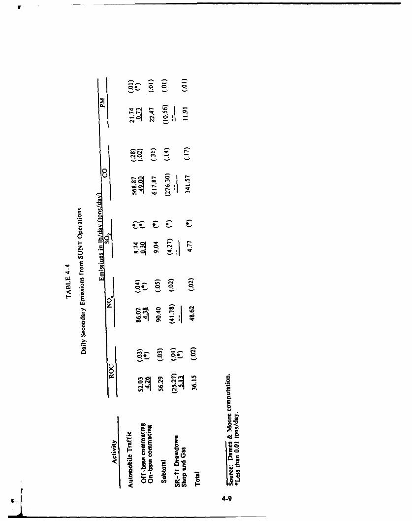
0..-
u
00
CC
00
C.,
r- 0
Z .
Ce
00
0 0*
t0 0
I--

00
0C6 t
C-,-
.j 2
.J 0
E F.(U E
gU 06
4-10

cumulative air quality impacts of SUNT aircraft with other base facilities will benegligible due to the intermittent use and extreme mobility of aircraft. The relocationof the SUNT operations will result in an increase in the Beale AFB air emissionsinventory, however, the large spatial spread of Beale AFB emission sources and itsrelative isolation from other major sources of emissions in Yuba County will result inan insignificant cumulative effect on air quality.
It is assurned that emissions from SUNY operations at Beale AFB will be similarto those currently occurring at Mather AFB. Since both are in the same regional airbasin, no significant cumulative impact on regional air quality is anticipated other thantnose emissions associated with construction related activities.
4.3.2 Mitigation Measures
Construction-related Mitigations. The following proposed mitigation measurewill help to reduce construction-related air quality impacts to insignificant levels:
During high wind conditions, watering of disturbed areas and/orapplication of chemical dust suppressants will be implemented to helpcontrol fugitive dust.
The following potential measures would further reduce construction-related airquality impacts:
Construction activity would be planned to minimize overlap of activitiesand subsequent overlaps in peak short-term emi-ions.
Vapor recovery systems would be installed on any gasoline-poweredconstruction equipment.
"* During periods of high ozone conditions, construction activity would betemporarily curtailed to minimize the potential for an ozone NAAQSand/or CAAQS violation.
"* Paving of high-use haul routes and covering of stock piles would beperformed to help minimize fugitive dust.
Operation-related Mitigations. The following potential mitigation measuresincorporated in SUNT operations would help to reduce operational air quality impactsto insignificant levels:
"* Development of an on-base and off-base transportation plan to encouragecar/van pooling and bus transportation.
"* 3tate-of-the-art natural gas boilers would be used at new facilities to theextent feasible.
4-11

4.4 WATER RESOURCES
Potential impacts to water resources will be similar at all areas whererealignment activities will be located. Because of this similarity, potential impacts andmitigation measures are discussed as a whole and are applicable to all areas.
Potential impacts associated with flooding could include damage to structuresand the interruption of SUNT activities. However, the potential for flooding in areaswhere the realignment activities will occur is considered to be very low due to thefollowing factors:
"* Limited watershed areas that would in turn limit the potential supply of
runoff onto these areas.
"* The relatively flat or gently rolling terrain.
"* Significant distance from the three principal drainages on Beale AFB tonew realignment facilities.
"* The relatively small, seasonal rainfall that characterizes the Beale AFBarea.
Therefore, the impacts of flooding in areas where SUNT activities are proposed arenot considered significant.
The increased water demand (Section 4.10) as a result of the realignment willbe primarily a result of domestic uses and is not expected to significantly affect regionalwater table levels or alter the direction of groundwater flow. Despite relatively highwater use in areas around Beale AFB for agricultural irrigation, the additional waterdemand as a result of SUNT activities is not expected to be significant with respect tothe base's or to overall regional groundwater availability, and is not anticipated toaffect other groundwater users in the area.
Existing surface water quality in Hutchinson Creek/Dry Creek, Best Slough, orother drainages will not be adversely affected by construction or operation-relatedactivities associated with the realignment. This is due to the remoteness of thesedrainages from construction areas and the relatively flat or gently rolling interveningterrain.
4.4.1 Cumulative Imnacts
Beale AFB is relatively isolated from other water users in the area. This,coupled with the fact that the additional groundwater supply necessary in support theSUNT realignment will not adversely affect regional groundwater conditions, suggeststhat cumulative impact to water resources will not be significant. This will be furtherreinforced when the SR-71 drawdown is complete and approximately 624 military andcivilian positions are eliminated from Beale AFB.
414-12

4A.2 Mitigation Measures
The following mitigation measures are proposed to reduce potential impactson water resources to insignificant levels:
"* Site grading activities will be minimized during the rainy months(November-March) to the extent feasible.
"* All grading and site preparation plans will incorporate best available
storm water management practices.
No other mitigation measures are proposed.
4.5 BIOLOGICAL RESOURCES
Construction of the 50-acre CAMS facility, as well as other flightline areastructures, will not result in significant adverse impacts to sensitive biological resources.The proposed new gymnasium lot contains a small vernal pool and two small poplartrees. This loss is considered insignificant because of the small size of the vernal pool(only 40 square feet) and the small number of trees, and because of the previousdisturbance in this area. Introduced annual grassland will be removed from manyfacility locations; however, this loss is considered minor in the context of the largeamount of similar habitat throughout Beale AFB.
Construction of an access road north of the CAMS site would result in theremoval of three or four vernal pools located along a small drainage. These pools aremostly small; the largest appears to be about 100 by 25 feet. Loss of these pools isnot considered a significant impact because: (1) the pools are small and not likely toprovide substantial habitat compared to other larger, more developed pools on thebase; and (2) this portion of the base does not represent an important vernal pool area(Personal Communication, John Thomson, Beale AFB, November 1989). It should alsobe noted that neither the base-wide SCS wetland study or the National WetlandInventory maps indicated the existence of these pools at the CAMS site, nor the poolat the proposed gymnasium site, due to their small size, shallow impoundments, andlow numbers.
Development of most of the Academic Complex facilities will not result in theremoval of any native habitat, nor any impacts to threatened or endangered plant orwildlife species. It is recommended that construction activities in the cantonment areabe excluded from the cottonwood tree grove and wetland habitat adjacent toHutchinson Creek.
An intermittent drainage with freshwater marsh vegetation and sparse riparianscrub is located near the preferred location for the Shop and Gas facility. Since it isadjacent to other structures and roadways, the drainage is not considered highlysensitive. As such, loss of this habitat is not considered significant.
4-13

The Parasail Area will require clearing and grading within a 3,000-foot-diametercircular road, improvement of an access road to the site, and installation of supportfacilities. The preferred parasail area near the southern base boundary will result inthe removal of the annual grassland habitat, possible removal of vernal pools, andpossible disturbance to an intermittent drainage course leading to Hutchinson Creek.The two alternative parasail areas south of Doolittle Drive and south of WarrenShingle Drive would primarily affect previously disturbed areas. They are likely tohave less impact on biological resources than the preferred parasail area near the baseboundary.
The USAF will coordinate all efforts associated with impacted wetland andvernal pool areas on base with the U.S. Army Corps of Engineers (COE). This wouldinclude identification and delineation of impacted wetland/vernal pool habitats inaccordance with the "Federal Manual for Identifying and Delineating JurisdictionalWetlands" (FICWD, 1989). Based on the results of these delineations, appropriatepermits will be applied for, and, if necessary, mitigation measures will be implementedin accordance with COE recommendations.
The construction of new facilities and conduct of SUNT operations will notimpact any known threatened or endangered vegetative or wildlife species on BealeAFB. In addition, these activities will not adversely affect migratory deer populationson base, or anadromous fish populations in Dry Creek/Best Slough.
4.5.1 Cumulative Imnacts
The realignment of Beale AFB will require the construction of a number ofnew facilities on the base. However, this action, in conjunction with the recentlyprogrammed force structure drawdown of the SR-71 program at Beale AFB, will nothave significant cumulative impacts to biological resources.
4.5.2 Mitigation Measures
In addition to coordinating with the COE regarding possible wetland/vernalpool habitats, the following measures are proposed to mitigate potential impacts tobiological resources to insignificant levels:
* Limit grading areas to the minimal amount feasible.
0 Exclude construction activities near the cottonwood tree grove in thecantonment area.
* Avoid wetland/riparian habitat adjacent to Hutchinson Creek in thecantonment area, and protect this area with use of silt curtain/fencematerial until construction in this area is completed.
0 Develop a landscape plan to re-establish vegetation in disturbed areas asquickly as is feasible. The plan should include the use of native speciesto the extent possible.
4-14

Develop a vernal pool mitigation area on base to replace similar habitat
loss.
4.6 ARCHAEOLOGICAL CULTURAL AND HISTORICAL RESOURCES
No standing historic structures or sites of specific ethnographic or heritageconcern have been identified on Beale AFB. Hence, the impact assessment focuseson potential effects to archaeological sites.
The realignment may cause both direct and indirect impacts to archaeologicalresources. Potential direct impacts would result primarily from ground disturbanceassociated with construction of the proposed facilities. These activities (use of heavyequipment, grading, excavation, and other disturbances), if conducted in the area ofarchaeological sites, may cause displacement, breakage, or removal of archaeologicalmaterials. Removal of archaeological materials would result in total data loss for theaffected area, while displacement of maierials would compromise the vertical andhorizontal contexts that are crucial for archaeological interpretation. If artifacts orother remains are broken or crushed, diagnostic elements are often lost.
The addition of new personnel to the base would increase the potential forindirect impacts to archaeological resources. In general, these types of impacts consistof casual collecting of surface artifacts or displacement of archaeological materialsresulting from increased use of base grounds. Casual collecting is of particular concernbecause formal artifacts, which are often particularly important for understanding sitefunction, are usually most susceptible to this activity.
Construction activity associated with the realignment will primarily occur inareas that are either classified Zone D or Zone E as it relates to potentialarchaeological sensitivity on Beale AFB (see Appendix B for a detailed explanationof these zones). The Academic Complex proposed for the cantonment area is locatedentirely within the zone of lowest sensitivity for the base (Zone E). Although none ofthe proposed impact area has been surveyed, a roughly 30-acre parcel about 200 metersto the northwest has been surveyed with negative results (Johnson and Kenton, 1982).No archaeological sites or historic locations are known to exist within this portion ofthe cantonment area and significant impacts to these types of resources are unlikely.
The flightline area is within the Prime Vernal Pool Terrain sensitivity zone(Zone D). A roughly 1/2-mile corridor to the east of Doolittle Drive has recentlybeen surveyed under a privately funded investigation, resulting in the discovery ofthree small bedrock mortar sites about 1 mile north of the potential impact area(Maniery, 1989). No surveys have been conducted within the proposed CAMS areaand no archaeological sites have been recorded there. One historic location is shownon the 1911 Downs Valley USGS topographic quadrangle, surveyed in 1909. Doyles1887 map identifies the landowner as M. Shaw. However, no surface manifestation ofthis structure currently exists in the area.
4-15

4.6.1 Cumulative Impacts
The SR-71 drawdown did not require construction or demolition of buildingsor create other disturbances in areas of historical or archaeological sensitivity.Therefore, the realignment of Beale AFB is not expected to create significantcumulative impacts to archaeological, historic, or cultural resources known to occuron base.
4.6.2 Mitigation Measures
Mitigation of archaeological impacts associated with the realignment of BealeAFB will be accomplished in accordance with regulations implementing Section 106of the National Historic Preservation Act. Consultation with the SHPO has beeninitiated regarding appropriate procedures to identify potentially significant culturalresources that could be affected by the project. Implementation of the followingproposed mitigation measures will reduce potential impacts to archaeological resourcesto insignificant levels:
" Initiate and/or complete archaeological surveys of previously unsurveyedportions of the project areas.
"* Conduct archaeological monitoring during construction to identifypotential buried archaeological features and artifacts and take appropriateactions to protect such resources.
" Consult with SHPO regarding the significance of additional culturalresources that may be identified during the archaeological survey anddevelop and execute appropriate treatment programs for such resources.
4.7 NOISE
In order to assess noise impacts related to SUNT operations at Beale AFB, theAir Force Engineering Services Center at Tyndall AFB, Florida generated a series ofnoise contours that incorporated projected SUNT operations with current base flightoperations using data produced for the AICUZ program. The noise contours weredeveloped using the computer program NOISEMAP, which is documented anddescribed in Appendix C.
Noise contours were generated for flying activities anticipated to occur with theSUNT operations. Figure 4-1 indicates a slight increase in noise levels, expressed inL,, over existing conditions. Although noise levels of 65 L. or greater cover a largearea around Beale AFB, the addition of the SUNT operations will not significantlyexpand this area. The area under the contours, 65 1.,, or greater, will be approximately36,300 acres, compared to 35,550 acres for current conditions. This represents anincrease of approximately 2 percent, which is considered insignificant. Land use aroundthe base is primarily agriculture and mineral extraction, which are not noise-sensitiveactivities.
i4-16
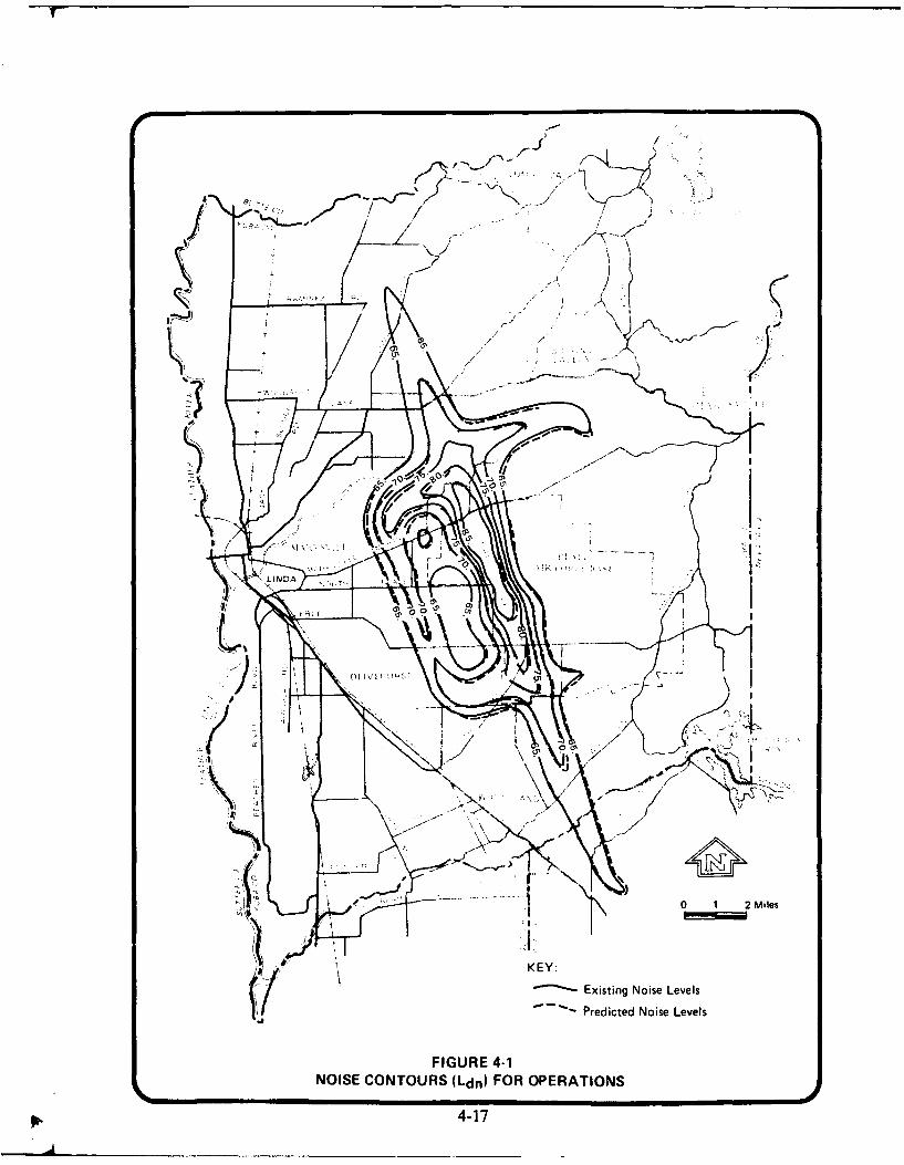
A 4~
0 11 2Miles
KEY:
~-Existing Noise Levels(1 Predicted Noise Levels
FIGURE 4-1NOISE CONTOURS (Ldn) FOR OPERATIONS
4-17
Aircraft flight operations associated with SUNT activities are at subsonic speeds.
Therefore, no impacts from sonic booms will occur as a result of the realignment.
4.7.1 Cumulative Impacts
The deactivation of the SR-71 program at Beale AFB has resulted in a reductionin flight activity and a subsequent reduction in noise levels surrounding the base. Noisecomplaints have decreased considerably since the deactivation of the SR-71 program.The expected noise reduction as a result of drawdown of the SR-71 program is nearlyequal to the predicted noise increase as a result of the realignment (HQ SAC, 1990).Therefore, the realignment of Beale AFB to accommodate the SUNT will have nosignificant cumulative effect on noise levels at Beale AFB.
4.7.2 Mitigation Measures
To further reduce potential noise impacts to insignificant levels, it has beenproposed that the USAF minimize night flight activity associated with SUNT operationsto the extent practical. No other mitigation measures are proposed.
4.8 ADUE
No significant impacts are expected to occur to existing land uses outside BealeAFB as a result of the realignment. Increased flight activity, associated with SUNToperations, is predicted to expand the land area included under the 65 L,, noisecontour by 2 percent (from 35,550 acres to approximately 36,300 acres). This increaseis not considered significant because current land uses in this area are primarilyagriculture and mineral extraction. In addition, this small increase should still beconsistent with the CLUP and Yuba County's General Plan.
4.8.1 Cumulative Impacts
No cumulative impacts to land uses are expected to occur as a result of theSUNT addition to Beale AFB.
4.8.2 Mitigation Measures
No mitigation measures are proposed.
4.9 IRANSPORTATION
The relocation of the SUNT to Beale AFB will increase personnel on the baseby approximately 1,602 persons--829 permanent party and an average of 773 students.Living quarters adjacent to the Academic Complex is planned for the students. Nodecision has been reached regarding the possibility of additional on-base housing forpermanent party personnel. Therefore, approximately 829 SUNT personnel can beexpected to live off base and travel daily by car to SUNT facilities in the cantonmentana flightline areas (as a worse-case scenario). These additional car trips will adverselyaffect the ability of the existing gates to accommodate traffic, especially during morningand evening peak periods. Information on expected changes in peak period round trips 4
4-18
is shown in Table 4-6. Additionally, dependents of SUNT personnel will travel to baseby car through the various base gates to take advantage of on-base facilities. Therelative impact on each gate will depend on destinations and time of day of travel.These impacts are expected to be adverse and significant, but mitigable.
Relocated SUNT personnel and their dependents will add auto traffic to theon-base road system. Detailed information on numbers of personnel expected atspecific on-base destinations is not available to quantify impacts at individual roadsand intersections. However, it is expected that a number of intersections currentlyL_. "r exceeding their capacity would receive increases in traffic volume. This trafficincrease represents an adverse and significant, but mitigable impact.
Parking on base will also be affected by the addition of SUNT personnelautomobiles. Additional parking space for the expected 1,602 new personnel will beneeded in the cantonment and flightline areas. It should be noted that parkingconvenient to many existing facilities in the flightline area is already limited. Thisrepresents an adverse and significant, but mitigable impact.
Rail and truck delivery of aviation fuel is also expected to increase as a resultof the proposed action. Information on the level of increased delivery activity thatwill be required to support the SUNT relocation has not been quantified by basepersonnel. However, rail and truck deliveries to support SUNT operations are notanticipated to have a significant impact to existing base facilities.
4.9.1 Cumulative Imracts
The deactivation of the SR-71 program will eliminate approximately 624positions, which will result in a small but beneficial impact to ground transportation.This beneficial impact will reduce the overall impacts on base transportation due torealignment.
4.9.2 Mitigation Measures
Improvements to transportation recommended in the Beale AFB DraftComprehensive Plan (EDAW, 1988) would help to mitigate impacts to gates, on-baseroads, and parking from the addition of SUNT personnel and their cars. Theserecommended improvements address capacity problems at several intersections onDoolittle Drive: standardization of control signing and marking; inadequate flightlineparking; poor parking layout design; two poorly aligned and narrow bridges on GavinMandery Drive; and lack of appropriate pedestrian and bicycle routes. A briefsummary of the potential improvements recommended in the Draft BaseComprehensive Plan follows.
* Improve a number of intersections on Doolittle Drive and implementmeasures to reduce traffic in the central cantonment area.
0 Install school zone signing and beacons according to the Manual onUniform Traffic Control Devices (MUTCD), as well as establish studentwalking routes and install crosswalks and crosswalk signs.
4-19

I..
06
c I
06)
cc
.00
402

SImprove parking lots, including construction of new parking facilities on
the flightline, and improve layout and access points for the major lots inthe cantonment areas.
* Upgrade striping and signs to conform with the MUTCD to improvesafety.
* Replace right-hand passing lanes on Gavin Mandery Drive and in frontof the hospital on Warren Shingle Drive with left-turn lanes to improvesafety.
* Install guide signs at appropriate locations with a level of information,'omprehensible in moving traffic.
0 Improve the roadside at the intersection of A Street and Doolittle Driveso that driveways for the fueling area can be differentiated from A Streetand thereby improve safety.
0 Develop a comprehensive pathway system in the cantonment and flightlineareas to improve pedestrian access.
* Develop a local road between A and B Streets as the primary access roadto the Base Exchange and Commissary parking lots in conjunction withplanned relocation of the Commissary.
0 Develop a collector road as the primary access point to the flightline usingsections of Douglas Street, Creasman Avenue, and Curtis Street toprovide safe and efficient travel in that area.
In addition to improvements recommended in the Draft Comprehensive Plan,additional mitigation measures are proposed to help reduce the impact of SUNT trafficon Beale AFB gates, roads, and parking to insignificant levels.
To accommodate the peak hour arrivals and departures, Doolittle, Main, andWheatland gates should be expanded. Additional lanes at Doolittle, Main, andWheatland gates with the appropriate additional security personnel to adequately coverthe lanes will allow the increased number of peak hour arrivals and departures to beprocessed without excessive traffic congestion.
A decrease in the number of single-occupant car trips should be encouraged toreduce traffic congestion and parking space requirements. A combination of ride-sharing, expanded on-base shuttle bus service, and pedestrian and bicycle travel willreduce on-base traffic generated by the SUNT relocation.
Additional parking spaces will be required even if a decrease in the proportionof single-occupant car trips is achieved. Up to 1,602 additional spaces could berequired if all the SUNT personnel have cars on base at one time. Parkingimprovements already planned or recommended in the Draft Comprehensive Plan
4-21

and as part of the planned SUNT facilities should be implemented for the relocated
SUNT personnel.
4.10 UTILITIE
Current electrical service and capacity is adequate to meet the additionaldemand anticipated by the addition of the SUNT to Beale AFB. Although increasedelectrical usage will occur as a result of the realignment, this impact is not consideredto be significant.
The addition of the SUNT will increase the average daily number of waterusers by approximately 2,000 (assuming 400 dependents), or 20 percent. This willincrease the average daily water usage to approximately 3.0 mgd in the winter and to7.2 mgd in the summer. When the SR-71 program is completely deactivated (June1990), these usage numbers will only increase by 10 percent to 2.75 mgd in the winterand 6.6 mgd in the summer as a result of the SUNT realignment. Although this is wellbelow the 11.25 mgd capacity of the base water supply system, excessive pumping mayincrease high mineral levels in the water.
The water treatment plant has a capacity to treat up to 7.0 mgd; however, theonly treatment is disinfection and chlorination. Additional treatment may be requiredto remove excess minerals due to excessive pumping (Personal Communication, Mr.Tony Guerraro, Manager Waste Treatment and Water Supply, Beale AFB, October1989). The water distribution system appears to be adequate over the base with theexception of the falling 18-inch water supply line leading from the well field area tothe main pump station.
A new BIDDS Communications System is currently planned for installation atBeale AFB, which is unrelated to the SUNT relocation. This system will be in placeand operational before the commencement of SUNT operations. The new BIDDSsystem has the capacity to handle present and planned growth at Beale AFB (includingthe SUNT relocation) into the foreseeable future. Therefore, no significant or adversecommunication impacts will occur.
4.10.1 Cumulative Imnacts
The realignment of Beale AFB will not present any significant cumulative effectsto the base electrical supply and communications systems. If the mitigation measuresproposed below are implemented, there will be no significant cumulative impacts toexisting water supply or usage. The unrelated but planned deactivation of the SR-71program will not provide any adverse cumulative effects to utilities.
4.10.2 Mitigation Measures
A number of measures could mitigate impacts to base utilities to insignificantlevels:
Electrical Supply and Communications. No mitigation measures are proposed.
4-22 T
Water Supply. To mitigate impacts to the water distribution system, thefollowing is proposed:
Replacement of the failing 18-inch water supply line from well field witha 20-inch line.
Potential mitigation measures include the following:
"* Addition of a second 8-inch supply line to the flightline area to ensureadequate and sustained water for firefighting purpuses.
"* Addition of booster pumps to deliver water to the family housing area.
* Upgrading of system to add treatment for manganese.
4.11 WASTE MANAGEMENT
Solid Waste Disposal. The landfill has 2,950,000 cubic yards (cy) capacityremaining or approximately another 45 years of life at projected use rates. Theaddition of the SUNT to Beale AFB is expected to increase solid waste disposal byabout 20 percent per month to about 6,300 cy per month. This will reduce the usefullife span for this facility to about 39 years, and represents an adverse and significant,but mitigable impact to solid waste disposal.
Wastewater Disposal. The existing wastewater and sewage disposal system hasadequate capacity to handle projected requirements generated by the realignment.However, the new kitchen in the flightline area will add flow volumes that exceed thelift pump capacities at the Building No. 1086 lift station. This is considered to be anadverse and significant, but mitigable impact.
All sanitary flow is delivered to the Beale AFB STP. The STP has a designcapacity of 5 mgd and presently peaks at 1.45 mgd. The STP has sufficient capacityto handle the 20 percent increase in volume expected to be generated (approximately1.75 mgd during peak periods) as a result of the SUNT relocation and is not expectedto experience any significant or adverse impacts.
During periods of heavy rain, stormwater runoff infiltrates the sanitary sewersystem and could cause an overflow condition if the operators did not meter the flowinto the plant by allowing receiving lines to backfill. To date, this has not causedsignificant problems. However, with the addition of the SUNT personnel and theaddition of increased hard surface areas that would allow for an overall increase instormwater runoff, this condition is considered to be potentially adverse and significant,but mitigable.
Hazardous Waste Generation and Disposal. The addition of the SUNT toBeale AFB is not anticipated to generate significant quantities of hazardous waste.These wastes would be limited to fuels, lubricants, antifreeze, and other similarproducts associated with the operation and maintenance of the T-37 and T-43 aircraft.Any waste generated as a result of the operation of these aircraft would be stored and
4-23

disposed of in accordance with existing base policies and proLedures for hazardousmaterials, as well as in accordance with appropriate State and Federal regulations.Therefore, no significant impacts relating to hazardous waste generation and disposalare anticipated.
Installation Restoration Progra . Current IRP activities at Beale AFB directedat cleanup of past hazardous waste disposal sites will continue unimpeded throughoutthe construction period, as well as during the operation of SUNT activities. The newor modified facilities required to accommodate the SUNT will not affect any identifiedIRP site with the exception of Site 22, which encompasses a broad area of the base andaddresses abandoned USTs. However, base-wide IRP remedial investigation/feasibilitystudies and subsequent remedial action will continue until cleanup is complete.Therefore, the realignment of Beale AFB to accommodate the SUNT will not adverselyimpact ongoing IRP activities.
Underground Storage Tanks. A UST survey of approximately 100 acres in theimmediate vicinity of the preferred location for the Academic Complex has beencompleted. The survey indicated several potential UST locations. Other areas wherefacilities are being constructed have not been surveyed. It is very unlikely that USTsexist in the planned Parasail Area or in the area planned for the CAMS. H3we,'er, itis anticipated that they will not present a significant impact to the overall developmentof facilities.
Asbesto. Asbestos may be present in some of the buildings identified fordemolition or renovation; however, a detailed sampling program has not yet beenconducted. The presence of asbestos is not likely to present significant impacts aslong as appropriate remedial actions are implemented to safely remove asbestos priorto demolition or renovation activities.
4.11.1 Cumulative Imgacts
No significant cumulative impacts to waste management are expected as a resultof the SUNT relocation. Reductions in hazardous waste generation as a result of thedeactivation of the SR-71 program will help to offset increases in solid and liquid wastegeneration expected as a result of the realignment.
4.11.2 Mitigation Measures
Mitigation measures could reduce potential impacts to waste management toinsignificant levels.
Solid Waste Disposal
A potential measure is to vigorously pursue a program to recycle wastes,especially paper, glass, and aluminum cans to help minimize landfill useand extend its expected life.
4-24
. .... ...
Wastewaterjg iZ&W
Two potential measures are:
* One hundred percent backup lift pumps at the Building No. 1086 liftstation to meet additional capacity needs.
Development of a stormwater management program with adequatepretreatment of possibly conaminated runoff. This will help minimizethe practice of allowing lines to backfill and reduce the potential foroverflow of the STP system.
Hazardous Waste Generation
No mitigation measures are proposed.
Installation Restoration Progam
No mitigation measures are proposed.
Underground Storage Tanks
It is proposed that:
"* In areas planned for SUNT facilities where geophysical surveys have beenconducted, ground t uthing will be accomplished to confirm initial results.If USTs are confirmed, they will be removed in accordance withapplicable county, State, and Federal regulations.
"* Geophysical surveys to confirm the presence of USTs will be completedprior to construction activities in areas identified for SUNT developmentthat have not been previously surveyed.
A complete detailed asbestos survey and sampling program is proposedon all buildings slated for modification and/or demolition. If the presenceof asbestos is confirmed, appropriate remedial measures should beimplemented in accordance with applicable State and Federal regulations.
4.12 SQClOECQNOMICS
To estimate the nature and extent of socioeconomic impacts, the EconomicImpact Forecast System (EIFS), an interactive computer system for evaluatingsocioeconomic impacts of military base mission changes on a user-defined region-inthis case, the two-county area of Yuba and Sutter Counties-was used. EIFS wasdeveloped by the Construction Engineering Research Laboratory of the U.S. ArmyCorps of Engineers and is maintained by the Department of Urban and RegionalPlanning of the University of Illinois at Urbana-Champaign. EIFS has a large data
4-25

base of socioeconomic information on every county in the United States, which can beincorporated into economic models to generate estimates of the effects on specifiedcounty or multi-county areas of changes in construction and operating activities atmilitary bases. Estimates of construction and personnel requirements for the SUNTrelocation developed by Beale and Mather AFB were input to the EIFS models toproduce projections of likely changes in area population, employment, incomes, school-age children, and government expenses and revenues. These changes are evaluatedbelow in the context of the baseline characteristics of the study region so thatconclusions may be drawn as to the extent of the action's socioeconomic impacts.
Impact-Generating Factors. The primary causes of socioeconomic impacts onthe residents of Yuba and Sutter Counties will be changes in base personnel levelsand new construction of facilities to accommodate the move.
The SUNT relocation's impact on the base's total annual operating costs isestimated at about $72 million per year, based on the change in total base personnel.In light of the fact that the local and/or regional area around Beale AFB willexperience an increased demand for goods and services, this increase is considered tobe an overall beneficial impact.
Dem.grp.býo. Most of the 829 new permanent personnel are expected torelocate over time from Mather AFB and the Sacramento area to Beale AFB and theMarysville area. The Mather AFB personnel and their dependents will account formost, but not all of the population increase that the SUNT relocation could cause.The economic stimulus of the base expansion is projected to induce secondaryemployment in the region, which could, in turn, attract some relocation of job seekersfrom outside the region.
Taking induced employment-related population growth into account, it isestimated that the total increase in Yuba-Sutter counties' population due to the SUNTrelocation could be approximately 4,100 persons. This increment would represent anaddition of around 3.3 percent to the two-county area's projected 1993 population ofabout 125,100 people. Thus, the projected increment of population due to therelocation exceeds historical average rates, but the impact is not considered to besignificant because this is a one-time change and not a continuing growth element.
E=lm~en . The SUNT relocation will generate new jobs in the region. Inthe short term, construction of the SUNT facilities is projected to requireapproximately 800 workers in the peak year (FY 92) of the 3-year construction phase(FY 91-93). The construction labor force is projected to number about 300 workersin FY 91 and 170 workers in FY 93. (This estimate was developed based on theprogrammed costs and assumes that 34.2 percent of cost is for labor.) The infusionof new construction payroll into the regional economy, plus procurement of materialsand services from local vendors, will also stimulate secondary employment in supportand service sectors. The EIFS model projects that total direct and indirect regionalemployment attributable to the construction work will amount to about 3,465person-years over the 3-year construction phase.
44-26

The SUNT relocation will also cause a long-term net increase in directemployment of permanent base military and civilian personnel to about 829 persons.Their consumption expenditures, plus those of the navigation students during their stayat Beale, wiU support and stimulate other employment in the region. The EIFS modelprojects that total regional direct and indirect employment supported by the SUNTactivities will average about 2,200 jobs.
Since contracts have not been awarded for the construction work or procurementof materials and services for the SUNT operation, it is not possible to identify whichportion of the base's overall employment and income effects would accrue specificalyto Yuba and Sutter Counties. It seems reasonable that one-fourth of the constructionwork would fall to Yuba and Sutter County contractors and construction workersbecause of their proximity to the site. The larger share of the work would probablygo to Sacramento-based contractors who have greater resources. It is estimated,therefore, that direct and indirect construction employment accruing to Yuba andSutter County residents from the SUNT relocation would amount to approximately 865person-years of work, with the peak level totaling approximately 200 jobs in FY 1992.This number would represent an increase of about 0.5 percent of the projected 1992resident civilian employed labor force, which is considerably less than the area's annualaverage growth rate of 1.3 percent per year. The projected short-term increment inconstruction-related local employment due to the SUNT is not regarded as a significantimpact and may result in a net beneficial impact to the area.
It is estimated that the majority of the indirect employment stimulated by theSUNT operation would be in Yuba and Sutter Counties because much of the secondaryemployment would be due to local consumption spending by the base personnel. Atwo-thirds proportion of the total SUNT operation-generated employment accruing tothe two-county area seems reasonable. This would amount to around 1,470 jobs (witha subjective margin of error of plus or minus 25 percent or 370 jobs). This one-timeincrease in jobs would occur between FY 91 and FY 93 and is not regarded as asignificant socioeconomic impact and may result in a net beneficial impact to the area.
Personal Income. Costs of constructing the SUNT facilities have been estimatedat $148.6 million, of which expenses for construction labor, materials and equipment,and design services to be expended within the 50-mile radius EIR of Beale AFB areprojected at approximately $122.3 million. The regional share was estimated on thebasis of the distribution of construction expenses for the base in FY 1988, whichshowed that 82.3 percent of that year's total constructin expenditures went tobusinesses and workers in the region (ERIS, 1988). The economic impact of the SUNTconstruction outlays on the EIR would amount to about $193 million over the threeyears of scheduled work, according to the EIEFS forecast model. This figure representsthe total increase in business volume in the EIR due to the realignment constructionwork at Beale AFB. About $70 million of the business volume change representsincome accruing to households in the region (including on-and off-base militarypersonnel) due to the infusion of construction payroll spending and local areaprocurement of construction materials and services. Assuming that one-fourth of thenew income, or about $18 million, actually accrued to Yuba and Sutter Countyhouseholds, the increment to the two-county area's total personal income ofapproximately $1.4 billion would be about 1.3 percent. This amount is less than the
4-27

area's recent trend of 3.5 percent per year since the early 1980s, which suggests thatthe construction income impacts would be insignificant and easily accommodated bythe Yuba City MSA.
Base operating expenses are estimated to increase by about $72 million peryear after completion of the SUNT relocation. This estimate is based on the projectednet change in base personnel applied to the base's total operating expenses in FY 88.About two-thirds of the base's FY 1988 expenditures accrued to businesses and workersin the EIR (ERIS, 1988). The regional economic impact of this spending, as measuredby the total annual increase in regional business volume attributable to the SUNT-related activities, is projected to be about $97 million per year, according to the EIFSforecast model. Of this figure, about $48 million per year would accrue to regionalhouseholds as personal income. As a measure of the significance of this increment ofincome, if two-thirds ($32 million) of the total were to accrue to Yuba and SutterCounty households, the increase would be about 2.3 percent of the total regionalpersonal income of $1.4 billion. This is substantially below the 3.5 percent per yearactually being experienced in Yuba and Sutter Counties, leading to the conclusion thatthe SUNT operations would have a small, but positive impact on the local economy.
Housil-g. The increase in Beale AFB's military and civilian personnel from theSUNT relocation is estimated at 1,292 military and 310 civilians. Development ofadditional housing under a build-to-lease arrangement with a private developer is beingconsidered. No decision has been reached on this issue. Rental vacancy rates in Yubaand Sutter Counties are running at approximately 5 percent, or 2,180 rental units (in1987). In addition, some transferring personnel will commute from their currenthomes. Thus, the incremental demand associated with the SUNT relocation would notbe expected to strain the local housing market supply or prices, and represents aninsignificant impact.
Eduati . The number of school-age children that may be associated with theSUNT relocation is estimated at between 450 and 475. The wide range is due to theuncertainty of how many navigation students at any one time might have dependentchildren and the amount of induced local population growth that the SUNT programmight stimulate. Most Beale AFB dependent children attend the Wheatlandelementary and high schools, which have ample physical capacity to accommodate thepotential increase in enrollment. Excess capacity in these schools is approximately1,660 seats-930 at the elementary level and 730 at the high school levels.
The primary issue for schools is financial assistance for dependents of Federally-employed personnel, which is provided under the Federal education impact assistanceprogram. If the assistance program is not decreased, any increase in enrollments canbe accommodated by hiring more teachers to maintain proper student-teacher ratios.In FY 88-89, education impact assistance for the Wheatland schools is projected toamount to $2.2 million, assuming 100 percent funding of the program (Cole, 1989).The $2.2 million in impact assistance was associated with a total of about 1,546Category A and B students in the two Wheatland school districts. Assuming the levelof funding remains constant and all the dependents of SUNT personnel attend theWheatland schools, the education impact assistance funding would increase by lx .weenapproximately $652,600 and $688,850 per year. These funds would represent an
4-28
increment to the two districts' revenue sources of about 7 percent based on their FY87-88 financial resources, totaling $9.6 million (Davis, 1990). Therefore, additionaldemands on the local education system are not expected to be significant.
Community Services and Facilities. The realignment of Beale AFB includesadditions to BOS facilities, as described in Section 2, and relocation of supportpersonnel from Mather AFB. These additional facilities and personnel will bringcommunity services and facilities up to the strength required to support therealignment.
4.12.1 Cumulative Impacts
The relocation of the SUNT to Beale AFB will have a small but beneficialimpact to the economic base of Yuba and Sutter counties. This impact will more thanoffset the socioeconomic impacts to the region as a result of the recent deactivationof the SR-71 program at Beale AFB. Impacts of the realignment to housing andeducation, although expected to be insignificant, may be seen as partially replacing lossof demand for these services resulting from the deactivation of the SR-71 program.
4.12.2 Mitigation Measures
Based on the above analyses of anticipated socioeconomic changes as a resultof the SUNT relocation, no mitigation measures are proposed.
4.13 UNAVOIDABLE ADVERSE IMPACTS
The impact analysis presented above indicates that the realignment will notcreate any unavoidable adverse impacts that cannot be mitigated to insignificant levels.
4.14 RELATIONSHIP BETWEEN SHORT-TERM USES AND LQNG-TERMPRODU YIIT
The short-term use of the environment necessary to accommodate therealignment at Beale AFB is not expected to result in significant long-term adverseimpacts on the productivity of the environment. The realignment represents acommitment of a relatively small portion of Beale AFB to a more intensive land use.Once the SUNT facilities are in place, use of the acreage for other purposes will beprecluded. However, facilities could be removed and the land restored toapproximately its original condition at the end of the project's useful lifetime. Theaffected areas should be available at that time for other possible beneficial land uses,contingent upon the then-prevailing plans and missions of Beale AFB.
Environmental protection measures would be included in the project to minimizethe effects of potential environmental impacts. Most environmental impacts would beof short duration, and recovery from impacts is expected to be relatively rapid. As aresult, there should be no significant narrowing of the range of beneficial uses of theenvironment, and no long-term significant risks to health and safety would result fromthe realignment.
4-29

4.15 IRREVERSIBLE AND IRRETRIEVABLE COMMITMENT OF RESOURCES
Irreversible and irretrievable commitments of natural resources that would resultfrom the proposed action include consumption of fossil fuels fortransportation/equipment and generation of electricity;, use of materials duringconstruction that cannot be recycled at the end of the project's useful lifetime; anduse of energy for the production of materiais used in new equipment and facilities.The relatively small scope of the realignment would not present any significant impacts.
The realignment contains no design elements that pose any danger of anenvironmentally significant accident, as long as recommended mitigation measures areimplemented. In contrast, the primary purpose of the SUNT mission is to afford state-of-the-art training to military personnel in support of a strong, safe, and effectivenational defense.
4-30
5.0 REFERENCES
Aerovironment, Inc., May 1987. Installation Restoration Program Phase II--Confirmation!Ouantification Stage 1 Final Report for Beale Air Force Base.Marysville. California.
Air Force Regulations 19-2.
Beale Air Force Base, 9th SRW/ACC, 1988. Beale Annual Report FY 1988.Economic Resource Impact Statement.
Beale Air Force Base, Housing Assistance Office, 9th CSG/DEEV,November/December 1988. Civilian/Military Locator Report.
Beckman, J.M., and H. Kenton, 1982. Letter Report: Intensive Cultural ResourceSurvey of Proposed Unaccompanied Enlisted Personnel Housing. Beale AirForce Base. Yuba County_, U.S. Army Corps of Engineers, California.
Black and Veatch, 1985. Underground Injection Control Permit Applications. InjectionWells 1. 2. 3 Photographic Wastewater Treatment and Disposal FacilityDepartment of the Air Force. Beale Air Force Base. California, Submitted toU.S. Environmental Protection Agency, Region IX. June 1985.
Bureau of Economic Analysis (BEA), U.S. Department of Commerce, April 1989.Survey of Current Business, Vol.69, No.4.
California Air Resources Board (CARB), Technical Support Division EmissionInventory Branch, December 1986. Emission Inventory 1983.
California Air Resources Board (CARB), 1984. Vol. XVI, California Surface Wind.limatQl•, State of California.
California Air Resources Board (CARB), 1985. VoL XVII, Air Quality Data Summary,State of California.
California Air Resources Board (CARB), 1986. VoL XVIH Air uality DataSummary, State of California.
California Air Resources Board (CARB), 1987. Vol. XIX, Air Quality Data Summary,State of California.
California Department of Finance (Cal DOF), Demographic Research Unit, 1988.California Statistical Abstract. 1988
California Department of Finance (Cal DOF), Demographic Research Unit, May 1989.Population Estimate of California Cities and Counties. January 1. 1988 to
,anuanL1222 Report 89 E-1.
5-1

California Employment Development (Cal EDD), May 1988. Annual PlanningzInformation: Yuba City Metropolitan Statistical Area (Sutter-Yuba County.1988-1989.
I
California Health & Safety Code, Division 26.
Center for Continuing Study of the California Economy (CCSCE), 1988. CalifornizCounty Projections. 1988 Edition'
C 2 M HILL, 1990. Installation Restoration Program Stage 2-1 Remedial Investigation,C- 2M HILL, Sacramento, California.
Code of Federal Regulations (CFR), Section 40 Part 300, Appendix B.
Code of Federal Regulations (CFR), Section 40 Part 1500-1508, November 1978.
Commission on Base Realignment and Closure, December 1988.
Davis, Gray, California State Controller, 1990. Annual Report of FinancialTransactions Concerning School Districts of California,
Department of the Air Force, HQ SAC, 1990. Environmental Assessment:Deactivation of the SR-71 Program. Beale Air Force. Californi
Doolittle, AJ., 1868. Township and County Map of the Central Part of CaliforniaSan Francisco.
Donovan, MJ., R.P. Hampson, and J.H. Cleland, 1984. Intensive Cultural ResourceSurvey of Excess Area Beale Air Force Base. California National Park Service,San Francisco.
Doyle, J.M., 1887. Official Map of Yuba County.
EDAW, Inc., 1988. Draft Base Comprehensive Plan for Beale Air Force BaseCaliforna-
Federal Register, 1989. Federal Regi.ter, VoL 54, No. 25.
Federal Register, 1989. Federal Regir, VoL 54, No. 47.
Federal Register, 1989. Federal Regir, Vol 54, No. 51.
Federal Register, 1989. Federal Regisr, Vol. 54, No. 55.
Federal Register, 1989. Federal Regiter, Vol 54, No. 61.
Federal Register, 1989. Federal Reist, VoL 54, No. 65.
Federal Register, 1989. Federal Registr, Vol 54, No. 89. A5-2
Federal Register, 1989. FedalRegitr, Vol. 54, No. 103.
Federal Register, 1989. Federal Register, Vol. 54, No. 134.
Federal Register, 1989. Federal Regst, Vol. 55, No. 35.
Federal Interagency Committee for Wetland Delineation (FICWD), 1989. FederalManual for Identifying and Delineating Jurisdictional Wetlands,Washington, D.C.
Holland, Robert F. 1985. Memo to Trip File Regarding Vernal Pools at Beale AFB,May 6, 1985.
Holyworth, USEPA, Division of Meteorology, Office of Air Programs, Janiuary 1972.Mixing Heights. Wind Speeds. and Potential for Urban Air Pollution Throughoutthe Contiguous United States. Research Triangle Park, North Carolina.
Jane's All the World's Aircraft 1977-78. Jane Publ. Inc., 1978.
Jane's All the World's Aircraft 1979-80. Jane Publ. Inc., 1980.
Jane's All the World's Aircraft 1989-90. Jane Publ. Inc., 1990.
Johnson, P.J., and S.L Kenton, 1982. Letter Report: Intensive Cultural RsouSurvey of Proposed Unaccompanied Enlisted Personnel Housing. Beale AirForce Base. Yuba County, U.S. Army Corps of Engineers, California.
Maniery, Mary, 1989. Cultural Resource Inventory and Evaluation: Beale Air ForceBase Rail Extension Project. Eastern and Central Corridors, Report submittedto Jones and Stokes. PAR Environmental Services, Sacramento, California.
Miller, C.L, 1961. Report of Archaeological Site Survey, Student paper, Departmentof Anthropology, California State University, Sacramento.
O'Haire, Karen, California Regional Water Quality Control Board, letter to HughStirts, U.S. Department of the Air Force, March 21, 1989.
Page, R.W., 1980. Groundwater Conditions at Beale Air Force and Vicinity. California.USDI-Geological Survey.
Peak, Ann S., 1981. Cultural Resource Assessment of the Yuba County WaterAgency's South County Irrigation Project. Report on file, Yuba County WaterAgency, Marysville.
Planning Assistance Team (PAT), March 1989. Base Realignment Siting Analysis forBeale Air Force Base. California Air Force Regional Civil Engineer, WesternRegion, San Francisco, California.
5-3

Poland, J.F., and R.E. Evenson, 1966. Hydrogeoloey and Land Subsidence. GreatCentral Valley. California, U.S. Geological Survey, Sacramento, California.California Division of Mines and Geology, Bulletin 190, Geology of NorthernCalifornia.
Raven, C.M., C.M. Woods, J.H. Cleland, and J.C. Smith, June 1987. A CulturalResource Overview of Beale Air Force Base. California, National Park Service,San Francisco.
Roop, W., 1981. The Archaeology of Vernal Pools: An Example from Placer County,
Paper presented at the Second Symposium on Vernal Pools and IntermittentStreams, Institute of Ecology, University of California, Davis.
Sacramento Area Council of Governments (SACOG), June 1987. Beale Air ForceBase Comprehensive Land Use Plan.
Sacramento Area Council of Governments (SACOG), 1988. Growth Projections byJurisdiction. Housing Projections for Sutter and Yuba Counties. 1988.
Thomas Brothers, 1940. Thomas Brothers Map of Yuba County. Californi .
Thompson and West, 1879. History of Yuba County. Californig, Oakland: Thompsonand West.
U.S. Department of Agriculture (USDA) Soil Conservation Service, 1985. Beale AirForce Base. Interim Soil Survey.
U.S. Environmental Protection Agency (USEPA), Office of Air Quality Planning andStandards, 1977. Guidelines for Air Quality Maintenance Planning and AnalysisVolume 10 (Revised): Procedures for Evaluating Air Quality Impact of NewStationary Sourcs. Publication No. EPA-450/4-77-001. Research Triangle Park,North Carolina.
U.S. Environmental Protection Agency, March 1974. Information on Levels ofEnvironmental Sound Requisite to Protect Public Health and Welfare with theAdequate Margin of SafeO.
U.S. Geological Survey, 1895. Smartsville. California' 1:125,000 topographic
quadrangle.
U.S. Geological Survey, 1910. Wheatland. California, 1:31,680 topographic quadrangle.
U.S. Geological Survey, 1911. Browns Valley. Californiz, 1:31,680 topographicquadrangle.
U.S. Geological Survey, 1915. Sencerville. Californi, 1:31,680 topographicquadrangle.
U.S. Geological Survey, 1947. heatliand-rCaiforia, 1:24,000 topographic quadrangle.
5-4

IU.S. Geological Survey, 1973. C=mp Far West. Califorfl, 1:24,000 topographic
quadrangle.
U.S. Geological Survey, 1973. Wolf-Californla. 1:24,000 topographic quadrangle.
U.S. Geological Survey, 1973. Wheatland. California. 1:24,000 topographic quadrangle.
U.S. Geological Survey, 1973. Browns Valley. Californi'. 1:24,000 topographic
quadrangle.
U.S. Geological Survey, 1973. Smartville. California, 1:24,000 topographic quadrangle.
U.S. Geological Survey, 1973. Rough and Ready. Californi3. 1:24,000 topographic
quadrangle.
Wescoatt, N., 1861. Official Map of Yuba County. California. San Francisco:
Britton & Company.
Yuba-Sutter Chamber of Commerce (Yuba-Sutter C of C), 1988. School Enrollment.
1988.
Yuba-Sutter Chamber of Commerce (Yuba-Sutter C of C), March 1989. Yjk-MI
Bu . Vol. VIII, No3.
5-5
6.0 LIST OF PREPARERS AND ORGANIZATIONSAND PERSONS CONTACTED
6.1 PREPARERSThe following people are responsible for the preparation of this Environmental
Impact Statement:
Oak Ridge National Laboratory
Charles R. Boston. Dr. Boston has a Ph.D. in chemistry from NorthwesternUniversity. He has managed more than 50 NEPA projects during his 36 yearsof experience, focusing primarily on DOD and Department of Energy work. Dr.Boston has published over 60 publications in referred journals.
J. Tim Ensminger. Mr. Ensminger earned a B.S. in Environmental Science anda M.S. in Biology from East Tennessee State University. Mr. Ensminger has 14years of experience including performing environmental assessments for actionsat several Air Force Bases and other DOD programs. He has authored 28publications.
Dames & Moore
Richard C. Tucker. Mr. Tucker holds both B.S. and M.S. degrees in CivilEngineering from the Georgia Institute of Technology. He has over 20 yearsof experience on engineering and environmental projects including managingnumerous environmental studies for military installations.
Gary L. Haward. Mr. Hayward earned a B.S. degree in Geology at NewEngland College and a M.S. in Marine Science from the University of SouthFlorida. He has 10 years of professional experience on environmental projects,primarily focusing on NEPA documents. He has managed many environmentalprojects including several in California.
MaggiB.arate. Ms. Brasted has a BA. degree from the University ofMaryland in Sociology where her studies concentrated on demographic statisticsand analysis. She has 6 years of experience in demographic and environmentalprojects.
James CleIand. Dr. Cleland has a Ph.D. in Anthropology from the Universityof Virginia. For 17 years he has performed and managed archaeological,historical, and ethnological assessments, surveys, and other studies. His recentexperience has been primarily in California.
Johgn.fG•y. Dr. Gray holds a Ph.D. in Plant Ecology, as well as a degree inBiology from the University of California. In addition to experience instructingat the university level, Dr. Gray has 8 years of experience performing andmanaging biological investigations. These investigations have included baseline
6-1

invent- -ies, impact analyses, and mitigation studies primarily in the westernUniteL States and particularly in California.
Rober Mott. Mr. Mott earned a BA in Economics from Michigan StateUniversity and a MA also in Economics from the University of California,Berkeley. For 26 years Mr. Mott has performed and managed economic studies.His recent experience has emphasized direction of socioeconomic impactassessment for environmentally sensitive projects, primarily in California.
Steve R. Radis. Mr. Radis holds a BA and MA in Climatology fromCalifornia State University, Northridge. For 5 years he has provided programmanagement and atmospheric dispersion modeling for various projects includingthose involving air quality, meteorology and climatology, and public health riskassessment.
Matthew F. Dunn. Mr. Dunn obtained a B.S. with honors in ChemicalEngineering from the University of California, Santa Barbara. He has 7 yearsof experience in areas of air quality engineering, regulatory analysis, andchemical engineering.
Cynthia A. Ellio. Ms. Elliot earned a B.S. in Meteorology from thePennsylvania State University. For 4 years she has provided air quality analysis,meteorological evaluations, and atmospheric dispersion modeling.
.Miari .. Ra. Ms. Raso holds a BA in Geography from the University ofCalifornia, Santa Barbara. Her 3 years of experience has emphasized air qualitymonitoring and noise surveys for various projects including severalEnvironmental Assessments.
6.2 ORGANIZATONS AND PERSONS CONTACTED
The following organizations and persons were contacted during the preparationof this Environmental Impact Statement:
Beale Air Force Base
Maj. George O¶Brien, Environmental and Contract PlanningCapt. Mark Plaster, Management Engineering TeamCapt. Tony Ronquillo, Public Affairs OfficeCapt. Christopher Sherman, Bioenvironmental EngineeringKirk Schmalz, Environmental and Contract PlanningRobert Woodson, Environmental and Contract PlanningJohn Thomson, Environmental and Contract PlanningTracy Kissler, Environmental and Contract PlanningGreg Miller, Environmental and Contract PlanningTony Guerrero, Manager Waste Treatment and Water Supply, Environmental
and Contract Planning
6-2

Brooks Air Force Base
Capt. Ike Andrews, IRP Program
Mather Air Force Base
Colonel McCormick, Base OperationsCapt. Byron Wall, Implementation Office
Headquarters. Strategc Air Command
Capt. Jamil Gornley, Engineering Services
Capt. Bob Harrison, Manpower
Rick AUman, Yuba County Planning Office
Bernie Engle, Air Pollution Control District
California Department of Fish and Game
Robert Hubbard
Jim Jokerst
6-3

APPENDIX A
Average Daily Air Emissions InventcxyFor Yuba County

- -. 1. 1 ; C ;
V.
CL.
m Go 00
.0
00 00
to C)Q P0
cc
0
'o6C 0 0Go.
0
oUDo
0 '00
c =
0004-3 b
COc a-0>
0 < o , P- o o <0 cmz wo0
< -r.
I t; ~''6 6666
A-1

",I I £ I 0 0 0
44)
"C-7 0 0
<m
M , i 0 0 0 0 0 00
"
CcI I I t I 4 '.
*0
C,
0
00 9:
SIIII r ='" I S I i * ,= i i i i I0 .
04 "
0 ~ ~ ~ 0 -. %C
v -4 0 6 r
• •b.
6 W3•---or. II I Irv-
0
A-2A-2

0 %- 1 -l '
mv 0i 0 0 0;
cu, T' 'q-
0
C4.
u to
C4u
00
0 0 915 gz-0% aO gzx
I-Z
rn ~ ~ ~ OF 4)a 0 f 00 00 VJ-z % = > o
A-3)
APPENDIX B
Archaeological, Cultural, andHistoric Resources

APPENDIX B
Archaeological, Cultural and Historic Resources
B.1 ARCHAEOLOGICAL SENSITIVITY ON BEALE AFB
The sensitivity zones for prehistoric resources (Figure B-i) were delineated onthe basis of physiographic characteristics believed to influence prehistoric activities and,in turn, the occurrence of certain types of remains. Descriptions of the zones appearbelow.
Perennial Streams (Zone A) - Prehistoric activities associated with perennial streamswould occur along the Dry Creek/Best Slough system and possibly Hutchinson Creek.These streams not only would have provided a stable water source for prehistoricinhabitants of the base, but would also support a riparian habitat containing relativelyabundant resources. Any habitation sites on the base are likely to be situated in thiszone.
Lower Foothills (Zone B) - The low, oak-covered foothills on the eastern portion ofthc, base probably experienced the second most intensive prehistoric use of any areaof the base. Surveys in nearby areas suggest that these hills were used for resourcegathering and processing, and are likely to contain isolated bedrock milling features.Hunting blinds, though not expected anywhere on the base, are most likely to be foundin this zone. Habitation sites may occur at the confluences of seasonal drainages in thiszone, but are less likely than along perennial streams.
Seasonal Streams (Zone C) - Hutchinson Creek and Reeds Creek host minor riparianassociations and may have provided economically important resources (grasses, sedges,forbs, and animals), particularly in the spring and early summer. Archaeologicalmanifestations of the use of this zone are expected to be sparse because of the lineardistribution of the resources.
Vernal Pool Terrain (Zone Dl - This is the area of the base where vernal pools aremost frequent. Vernal pools have elsewhere been recognized to have provided minorconcentrations of critically timed resources, and have been observed to be associatedwith sparse scatters of artifacts (Roop, 1981).
Other Areas (Zone E) - Areas away from water sources or prehistorically significantresources are generally unlikely to contain archaeological sites, but may have containedmicroenvironmental resources not predictable based on present information. Surveysof nearby areas, however, indicate that these areas were rarely used.
B.2 PREVIOUSLY RECORDED ARCHAEOLOGICAL AND HISTORIC SITES
Table B-1 and B-2 present information relative to previously recordedarchaeological and historic sites in Beale AFB.
B-1
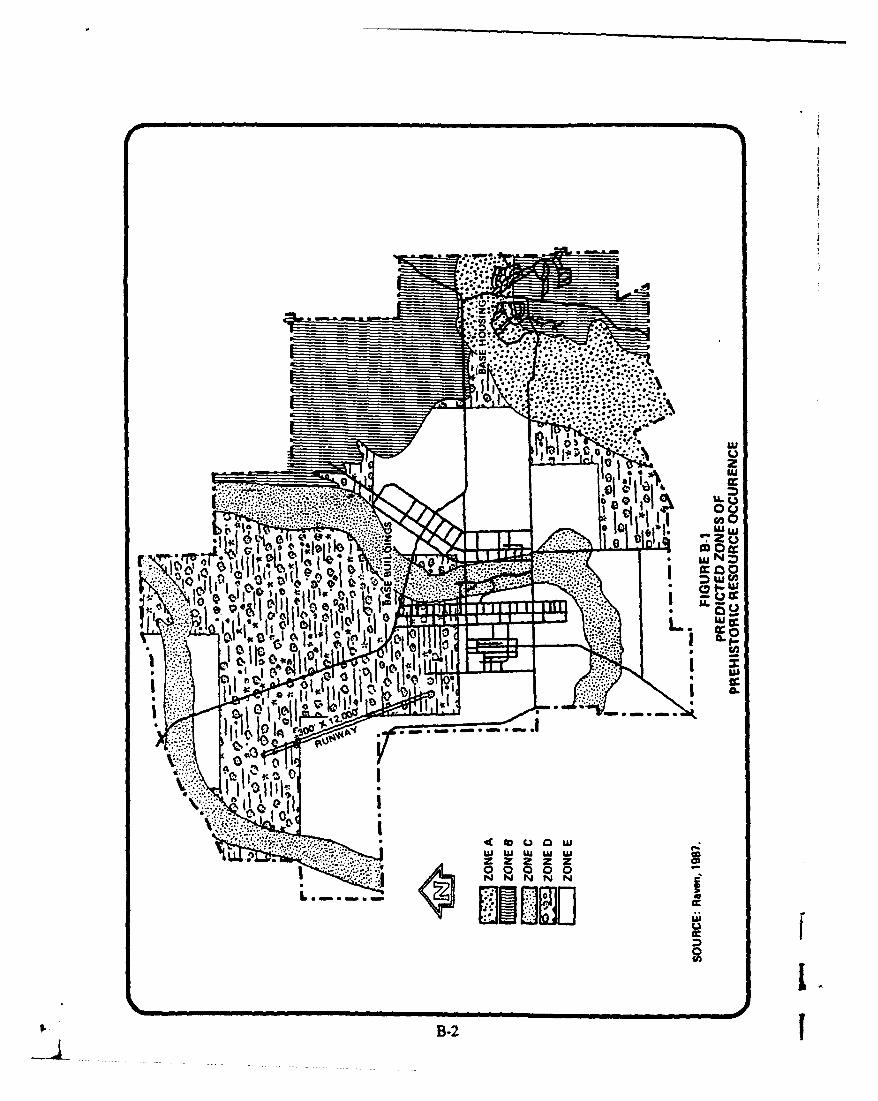
IaaU.
U Na08
oi mojw
10
I~~~ *t*~
LU
Ix5. B-2A

00 0 0 00 00 0% 00 0% 00
to0 0 0 0 0
> > > > ~o o0 0 0 0
4) 4
4) c )4 4 ) 4) 4) cU~~~~ V : V * 3
a-0 vW 41 .0 W >3 2Wý*E W
a- 0 (0< 0v< 0 << 0
4n
u 480 .0 06 4uIL 0.! 0A 0 0 %0
-0 1C6 0) 4 0.zA W; c -0xo
.0Cin0
a- M M
U ~a-B-3

00 00 00 R 0
M~~4 4)Zw z L06t~~ ~ ~ ~ = C6 m- . zA 6 S0 C. 06 A 6 =
o< ~ ~ ~ ~ ~ ~ ; o<o <o < <o <o
V%- ) V)4 ) 4 ) 4 ) 4 ) 4
-. - 4 V V) V *0 ) 4) ~
4) ~ 4) 4'~4) C.~ C~ C 0 0 C C
CV c v 0 0 ~ 0 .06 'Da E
00
0 I-
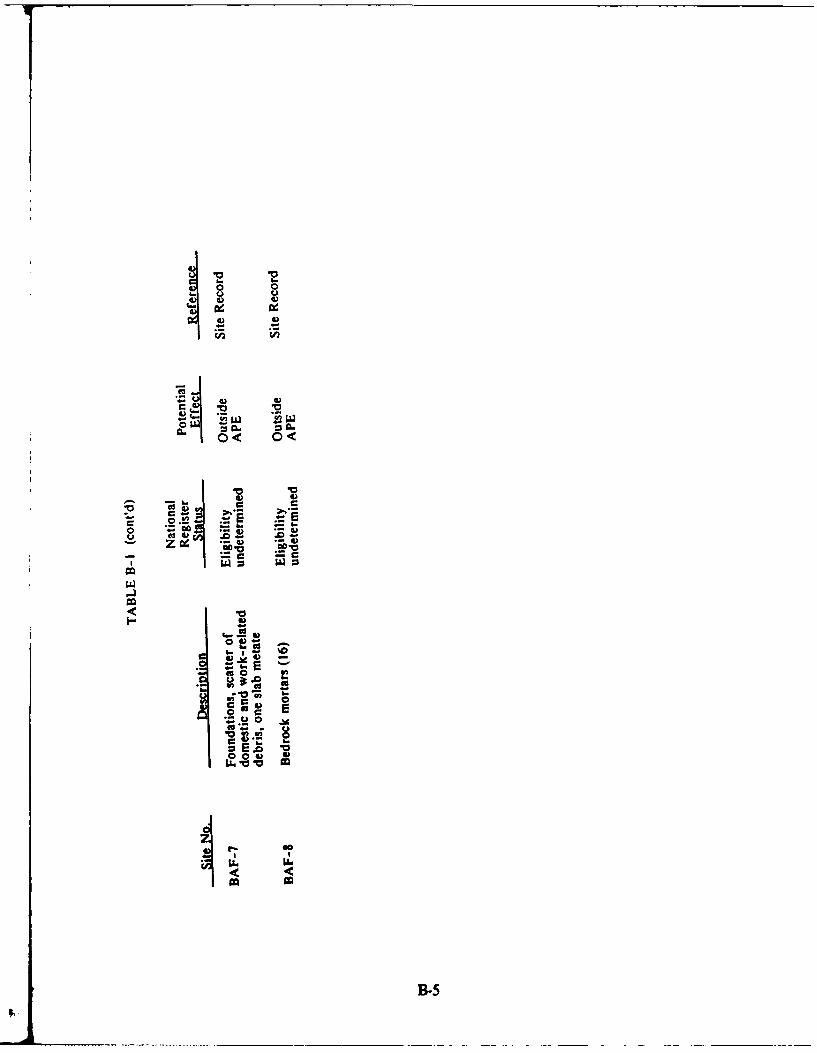
0 0
I I
S- - C ,.,
cc 04 O .0 @a
wo
-B-

TABLE B-2
Historical Locations on Beale Air Force Base
Resource Twe Number
Unidentified Structures 51
Homesteads 23
Roads 19
Mining Ditches 4
Schools 3
Trails 2
Hotels 2
Business (Riley & Company) 1
Community (Erle) 1
Dance Hall (Community of Erie) 1
Cemetery 1
TOTAL 108
B-6r

B.3 SITES ELIGIBLE FOR THE NATIONAL REGISTER
As previously shown on Table B-i, two of the archaeological sites at Beale AFBhave been determined eligible for inclusion on the National Register. A briefdescription of these sites is provided below.
Site 1 - YUB-1157
This site is located in the vicinity of Best Slough in the southern portion ofBeale AFB. It contains a number of bedrock mortar pits in four zones ofexposed, decomposed sandstone.
Site 2 - YI.B-1161
This site is located west of a southwest trending intermittent tributary to DryCreek south of the family housing area. It appeared to be a short-term, perhapssingle use, chipping station where a large number of flakes/debitage have beenfound.
B-7

APPENDIX C
Noise Metrics
APPENDIX C
Noise Metrics
C.1 BASIC ATTRIBUTES OF SOUND
Noise may be defined as unwanted sound. An acceptable definition of soundis that it is a physical disturbance of the atmosphere that can be detected by the humanear. Factors that influence people's perception of such physical disturbanct.2 as "noise"are:
"* The magnitude of the sound level."* The duration of the sound event."• The number of such events in a given time period (such as aday)."* The time of day of these events.
The results of this analysis qualify these effects in terms of the noise metrics
used in this report. These are describe in the following sections.
C.2 A MEASURE OF INSTANTANEOUS SOUND LEVEL
A basic fact of human hearing is that the hum ..n ear is more sensitive to soundenergy at higher frequencies than at lower frequencies (that is, the ear does no* havea "flat" frequency response). Furthermore, the ear's relative sensitivity to differentfrequencies changes somewhat with the level of the sound. This effect, however, ismost pronounced at lower sound levels. Any sound level measure that purports tocorrelate well with people's subjective assessment of the loudness or noisiness of soundmust account for this variable sensitivity to differing frequencies.
One approach for obtaining an accurate correlation between measured sounulevels and subjective human response was the introduction of frequency weighingnetworks in sound level meters. The sound level meter is a device for measuring soundpressure levels. The small pressure fluctuations are detected by an extremely sensitivemicrophone and transformed into an electrical signal. By means of electronic circuitry,this electrical signal is amplified and displayed on a meter in decibels (dB). Withorigins dating back to the mid-1930s, the A-weighing network is still in widespreadinternational use today. This network discriminates against the lower frequencies andvery high frequencies, to which the ear is less sensitive, according to a relationshipapproximating a person's subjective reaction in terms of loudness at moderate soundlevels.
In past laboratory and field studies, it has been found that people make relativejudgments of the "loudness," or the "annoyance" or "disturbance" of sounds thatcorrelate quite well with the A-scale levels of those noises. However, a change of 10dB in the A-level corresponds roughly to a subjective judgment of the halving ordoubling of the loudness or noisiness. In other words, a sound judged to be twice asloud as another sound would only have a sound level approximately 10 dB greater than0),e first sound (even though the 10 dB change corresponds to a factor of 10 in actual
C-1

sound energy). On the other hand, the difference of one or two dB between sounds,although probably detectable if heard within a short time interval, would not bc judgedto be significantly different in loudness by most observers. Table C-1 shows therelationships between A-weighted sound level and relative loudness for every-day noisesources.
C.3 A MEASURE OF INDIVIDUAL NOISE EVENTS
Of major interest in this report is the noise produced by aircraft during takeoffand landing operations. These noises fall into the broad category of "transient" noises,which come and go in a finite period of time. Aircraft takeoff, landing, and flyovernoises may be characterized as sound signals that increase in level, generally over aperiod of several seconds, to a maximum value, then decrease, and eventually mergeinto the fluctuating background noise.
Dependent primarily on the type of aircraft, type of operations, and distancefrom the observer to the aircraft, the maximum flyover noise levels will vary widely inmagnitude ranging from levels unnoticed in the presence of other background noisesto levels sufficiently high to create feelings of annoyance or to interfere with speech orsleep.
The duration will also vary depending on the proximity of the aircraft, speed,and orientation with respect to the observer. Unfortunately, the maximum noise levelrating ignores the duration aspect of the event. Extensive psychophysical research hasshown that for two events of the same maximum level, the longer of the two will invariably be rated as the noisier or more annoying.
Over the years, several mathematical models have been proposed to accountfor this observation. The model that is in common usage today asserts that subjectiveannoyance is related to the total amount of perceived acoustic energy in the noiseintrusion. Computationally, the total energy is determined by measuring theinstantaneous A-level at closely spaced intervals in time (e.g., every h second) andsumming these readings by logarithmic additions. The analyses in this report are basedon the SEL (Sound Exposure Level), which is the energy summation of the A-levelover the upper 10 dB of the noise signal. The SEL is being widely used to describethe noise of a variety of transportation noise sources.
C.4 A MEASURE OF DAILY NOISE EXPOSURE
Descriptors of individual aircraft noise intrusions are helpful in comparing oneaircraft with another or in relating the aircraft noise to other sources of noise in thecommunity. However, community response to aircraft noise is not based on a singleevent, but on a series of events over the day. Factors that have been found to affectsubjective assessment of the daily noise environment include (1) the noise levels ofindividual events, (2) the number of -vents per day, and (3) the time of day at whichthe event occurs. Most environmental descriptors of noise are based on these threefactors, although they may differ considerably in the manner in which the factors aretaken into account.
C-2
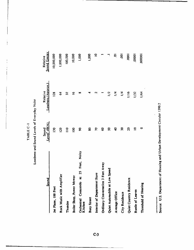
0 0C00> 0 0ýCý 0 ý 0 L 0ý 0 0 - 0 0D 0
g~ 0 D a ~ - - .0 0
0~0 0 q 0 0 Go C4 I0v
S0 0> Co-C
mc C* 00 r, %V %n - ' V (
< 0
cc c
~0 <0
-~ 0
M~ G en
it 0
00
CC
C-3

Any single-number descriptor of a complex noise environment represents adrastic simplification of the real-world conditions. However, the administrative andgeneral usefulness and the simplicity of a single number descriptor results inwidespread use of such measures for regulatory, administrative, and planning purposes.The U.S. Air Force has adopted the average day-night sound level (LI,,) as the measureof the noise regulations, which is widely employed throughout the country as adescriptor of community noise environment.
The 4, represents the equivalent level (also denoted as average level) over a24-hour period with the noise occurring at night (10 p.m. to 7 a.m.) multiplied by afactor of 10 (10 dB). The I,, incorporates a 10-dB nighttime weighing for noisesoccurring between 10 p.m. and 7 a.m. to account for the presumed greater potentialdisturbance of people by nighttime noise. This presumption is partially substantiatedby community complaint studies and social survey data that indicate that the samenoise environment is considered more disturbing or annoying during the nighttimethan during the daytime. There is a greater need at night for a quiet environment inwhich to sleep and relax. In most communities, the exterior background noise leveldecreases during the night by 10 dB or more, and the activity inside homes alsodecreases. These both contribute to a lowering of interior noise levels. Consequently,any high-level intrusive noise can be expected to be more disturbing during the night.
The L,, may be determined in two different ways. It may be calculated bymeasuring the noise either continuously or on a discrete sampling basis throughoutthe 24-hour period. In practical applications, 4, is usually computed by sampling thenoise one or more times a second and calculating the equivalent level for each hourlyperiod to obtain hourly noise levels. The L, is then computed from the set of 24hourly levels, after adding the appropriate weighing to the night levels.
C.5 L.CRI•TERION VALUES
Current Air Force guidelines, in the Air Installation Compatibility Use Zone(AICUZ) programs, stipulate I, as the upper limit for residential development unlessspecial noise insulation features are incorporated into buildings. The choice of 65 dBinvolves an administrative decision that necessarily involves tradeoffs between desireto eliminate all community annoyance with aircraft noise, consideration of economicand political factors, and community and military needs for air transportation.
The choice of a 65 dB I, criterion is supported by regulations andadministrative standards adopted by other governmental agencies. For example, HUDhas adopted an 4, level of 65 dB as the upper limit of acceptable aircraft and non-aircraft noise with regard to residential development and governmental funding forcommunity planning. The I4, value used by the FAA to define residential noise impactareas around airports is 65 dB. A recent American National Standard Institutestandard on land use planning with respect to noise also suggests a limit of 1, 65 forresidential land use.
The above discussion suggests that the criterion of 65 dB is reasonable in orderto achieve a balance that takes into consideration the air transportation needs of the
C4

conmn•niaty and the desired goals to minimize annoyance and noise interference.However, it is clear that setting a 65 dB 1.,, criterion will not eliminate all annoyanceor community dissatisfaction. And for some activities, the L,, criterion should besupplemented with other criteria regarding levels of individual noise intrusions.
In the absence of aircraft noise, people in suburban and urban areas are exposedto considerable noise due to other sources, the most prevalent of which is motorvehicle traffic. Figure C-i shows the approximate range of day-night levels for differenttypes of community noise exposure.
C.6 COMPATIBLE LAND USE
Most studies on residential aircraft noise compatibility recommend no residentialuses in noise zones (NZ) above L., 75. Usually no restrictions are recommendedbelow 1, 65. Between L,, 65-75, there is currently no consensus. These areas maynot qualify for federal mortgage insurance is residential categories according to24 CFR 51 (adopted July 12, 1979). In many cases, the approval of the U.S.Department of Housing and Urban Development (HUD) requires noise attenuationmeasures, the Regional Administrator's concurrence, and an Environmental ImpactStatement. Past Air Force experience and the lack of definitive criteria do not justifyan Air Force recommendation to categorically prohibit residential uses in these areas,although these uses may be undesirable. However, wherever possible, residential usesshould be located below 1, 65.
Most industrial/manufacturing uses are compatible in the airfield environs.Exceptions are uses such as research or scientific activities that require lower noiselevels. Noise attenuation measures are recommended for portions of buildings devotedto office use, receiving the public, or where normal background noise level is low.
The transportation, communications, and utilities categories have a high noiselevel compatibility because they generally are not people intensive. When land is usedfor these purposes, the use is generally very short in duration. Where buildings arerequired for these uses, additional evaluation is warranted.
The uses of commercial/retail trade and personal and business servicescategories are compatible without restriction up to L. 70; however, they are generallyincompatible above L,, 80. Between LV 70-80, attenuation should be included in thedesign and construction of buildings.
The nature of most uses in the public and quasi-public services category requircea quieter environment; attempts should be made to locate these uses below 1, 65, orprovide adequate attenuation.
Areas where noise levels exceed 4,, 75 are not generally recommended forrecreational uses. Buildings associated with golf courses and similar uses should besound attenuated.
C-5

LdnDAY-NIGHT
CUALITATIVE SOUND LEVELDESCRIPTIONS (Decibels) OUTDOOR LOCATIONS
-90-LOS ANGELES- 3rd FLOOR APARTMENT NEXT TO FREEWAY
LOS ANGELES V6 MILE FROM TOUCH DOWN ATMAJOR AIRPORT
CITY NOISE _80- LOS ANGELES- DOWNTOWN WITH SOME CONSTRUCTION(DOWNTOWN MAJOR ACTIVITY
METROPOLIS) HARLEM - 2 nd FLOOR APARTMENT
i VEY -70- BOSTON -ROW HOUSING ON MAJOR AVENUE
NOISY URBANOY--
_ • • W A TTS - 8 M ILES FRO M TO U CH D O W N A T M A JO R A IRPO RTz 'EWP ORT- 3 5MILES FROM TAKEOFF AT SMALL AIRPORT
RYURBAN --
** LOS ANGELES-OLD RESIDENTIAL AREA
SUBURBAN±__
.SM ALL T FILLMORE-SMALLTOWN CUL-de-SACSQUIET --501 ,SAN DIEGO- WOODED RESIDENTIAL
--- ___ C A L I F O R N I A -T O M A T O F I E L D O N F A R M
-40-
SOURCE: UNITED STATES ENVIRONMENTAL PROTECTION AGENCY. INFORMATION ONLEVELS OF ENVIRONMENTAL SOUND REQUISITE TO PROTECT PUBLIC HEALTHAND WELFARE WITH THE ADEQUATE MARGIN OF SAFETY.MARCH 1974, P. 14.
FIGURE C-1EXAMPLES OF AVERAGE DAY-NIGHT
SOUND LEVELSLdn
C-6
With the exception of forestry activities and livestock farming, uses in theresource production, extraction, and open space categories are generally compatiblewithout restriction.
C.7 NOISEMAP PROGRAM DOCUMENTATION
The NOISEMAP computer program is a comprehensive set of computer routinesfor calculating noise exposure contours for airport operations. The program wasdeveloped under sponsorship of the U.S. Air Force. The program permits calculationof the noise environment in terms of L,,, noise exposure forecast, or community noiseequivalent levels. With simple modification of the input data, NOISEMAP also candevelop noise level contours, typically in terms of effective perceived noise level orsound exposure level for individual aircraft operations.
4, contours produced by NOISEMAP are relied upon by the Air Force as theprimary descriptor of air base noise exposure. It forms a primary technical tool for theAICUZ program. NOISEMAP is also used by the U.S. Navy, U.S. Army, U.S.Environmental Protection Agency, and several state agencies and consultants todevelop noise environmental contours for civil and military airports. NOISEMAP isapproved by the Federal Aviation Administration (FAA) for use in FAA-funded airportstudies.
The program and underlying technical concepts are very well documented inthe technical reports. The basic modeling concepts, guidelines for acquiring noiseperformance data, application guide, and the basic computer program are describedin the following five reports:
Bishop, D.E., Community Noise Exposure Resulting from Aircraft Operations:Application Guide for Predictive Procedure, Air Force Report AMRL-TR-73-105, November 1974 (AD A004818).
Galloway, WJ., Community Noise Exposure Resulting from Aircraft Operations:Technical Review, Air Force Report AMRL-TR-73-106, November 1974 (ADA004822).
Bishop, D.E., and Galloway, WJ., Community Noise Exposure Resulting fromAircraft Operations: AcQuisition and Analysis of Aircraft Noise andPerformance Data, Air Force Report AMRL-TR-73-107, August 1975 (AD017741).
Reddingius, N.H., Community Noise Exposure Resulting from AircraftOperations: Computer ProraAM Operator's Manual, Air Force Report AMRI.,TR-73-108, July 1974 (AD 785360).
Horonjeff, RD., Kandukuri, R.R., and Reddingius, N.H, Community NoisExposure Resulting from Aircraft Operations: Computer ProMgam Description.Air Force Report AMRL-TR-73-109, November 1974 (AD A004821).
C-79.
The original computer program operator's manual has been updated to reflectprogram changes and is available as an Air Force report:
Beckmann, J.M., and Seidman, H., Community Noise Exposure Resulting fromAircraft Operations: NOTSEMAP 3-4 Computer Proram Operator's Manuial,Air Force Report AMRL-TR-78-109, December 1978 (AD A068518/OGA).
Basic noise information for military aircraft is documented in the following sixvolume report, prepared by the U.S. Air Force Aerospace Medical ResearchLaboratory:
Speakman, J.D., Powell, R.G., and Cole, J.N., Community Noise ExposureResulting from Aircraft Operations: Acoustic Data on Military Aircraft, AirForce Report AMRL-TR-73-110, November 1977.
Vol. 1 - Acoustic Data on Military Aircraft (AD A053699).Vol. 2 - Air Force Bomber/Cargo Aircraft (AD A053700).Vol. 3 - Air Force Attack/Fighter Aircraft (AD A053701).Vol. 4 - Air Force Trainer/Fighter Aircraft (AD A053702).Vol. 5 - Air Force Propeller Aircraft (AD A055079).Vol. 6 - Navy Aircraft (AD A056217).
A military aircraft noise data digital tape file for use with NOISEMAP isavailable upon request from:
6570th Aerospace Medical Research LaboratoryAMRL/BBEAir Force Systems CommandWright-Patterson AFB, Ohio 45433
Computer programs for computing noise versus distance curves from noise dataat single ground locations have been developed by the University of Dayton and aredescribed in the following report:
Mohlman, H. T., Computer Programs for Producing Single-Event Aircraft NoiseData for Specific Engine Power and Meteorological Conditions for Use withUSAF Community Noise Model (NOISEMAP), Air Force Report AFAMRL,TR-83-020, April 1983.
Base noise and performance characteristics for major civil aircraft were initiallycollected and described in several reports prepared under EPA sponsorship:
Galloway, WJ., Mills, J.F., and Hays, A.P., Data Base for Predicting Noise fromCivil Aircraft: Flight Profile Prediction, BBN Report 2746R, March 1976.
Bishop, D.E., Mills, J.F., and Beckmann, J.M., Effective Perceived Noise LevelVersus Distance Curves for Civil Aircraft, BBN Report 2747R, February 1976.
C-8!. f

Bishop, D.E., Mills, J.F., and Beckmann, J.M., Sound Exposure Level VersusDistance Curves for Civil Aircraft BBN Report 2759R., February 1976.
More recently, the civil aircraft noise and performance data have been reviewedand updated for the FAA. These data are incorporated into the current versions of theFAA's Integrated Noise Model airport noise computer program.
Bishop, D.E., and Beckmann, J.M., Civil Aircraft Noise Data for Computationof Aircraft Noise Contours, BBN Report 4440 (draft), November 1980.
Potter, R.C., and Mills, J.F., Aircraft Flight Profiles for Use in Aircraft NoisePrediction Models, BBN Report 4594 (draft), January 1981.
Potter, R.C., and Mills, J.F., Aircraft Flight Profiles for Use in Aircraft NoisePrediction Models, BBN Report 4594 (draft), January 1981.
Following the original development of NOISEMAP, a series of research andsensitivity studies concerned with various aspects of NOISEMAP assumptions andmodeling algorithms has been undertaken. Sensitivity refers to the variability of noisecontour size and shape resulting from changes in modeling algorithms or input data.These studies are documented in the following Air Force reports:
Bishop, D.E., Dunderdale, T.C., Horonjeff, R.D., and Mills, J.F., SensitiviStudies of Community-Aircraft Noise Exposure (NOISEMAPM PredictivePedel , Air Force Report AMRL-TR-75-115, March 1976 (AD A026535).
* Tone Corrections."* Runup Weightings."• Temperature and Pressure Altitude."* Excess Ground Attenuation and Airframe Shielding Algorithms.
Bishop, D.E., Dunderdale, T.C., Horonjeff, R.D., and Mills, J.F., FutherSensitivity Studies of Community-Aircraft Noise Exposure (NOISEMAP)Prediction Procedures, Air Force Report AMRL.-TR-116, April 1977 (ADA041781).
"* Tone Corrections."* Excess Ground Attenuation and Fuselage Shielding Models.* Climatic Variations.
Fidell, S., Test Plan for Aircraft Runup Noise Penally Evaluation, Air ForceReport AMRL-TR-75-110, March 1976 (AD A026209).
Walker, D.Q., Aircraft Sideline Noise: A Technical Review and Analysis ofContemporary Datl Air Force Report AMRL-TR-76-115, April 1977 (ADA042076).
Walker, D.Q., An Analysis of Aircraft Flyover Noise, Air Force Report AMRILTR-78-8, April 1978 (AlD A058522).
C-9
9.i
Extended capabilities of NOISEMAP to include noise from helicopters andfrom special aircraft operations are described in the following reports:
Galloway, WJ., Helicopter Noise Level Functions for Use in Community NoiseAnalyses, Air Force Report AMRL-TR-78-87, December 1978.
Bishop, D.F., Procedures and Data for Predicting Day-Night Levels forSupersonic Flight and Air-to-Ground Gunnery, BBN Report 3715, prepared forthe Air Force Civil Engineering Center (draft), August 1978.
The NOISEMAP program has been modified to permit convenientdetermination of demographic information within noise contour boundaries, asdescribed in the following reports:
Seidman, H., and Bavely, C., Computer-Aided Collection of Demographic Datawithin Day-Night Level Contours: Two Test Cases, Air Force Report AMRL-TR-78-39, August 1978.
Seidman, H., Incorporation of Environmental Impact Indices into NOISEMAP,Air Force Report AMRL-TR-81-31, February 1981.
Initial NOISEMAP field validation studies and the development of detailedtechniques for field measurement of air base noise for comparison with NOISEMAPpredictions have been undertaken. They are documented in the following reports:
Seidman, H., Horonjeff, R.D., and Bishop, D.E., Validation of Aircraft NoiseExposure Prediction Procedure, Air Force Report AMRL-TR-76-111, April1977 (AD A041674).
Rentz, P.E., and Seidman, H., Development of NOISECHECK Technology forMeasuring Aircraft Noise Exposure, Air Force Report AMRL-TR-78-125, May1980.
Bishop, D.E., Harris, A.H., Mahoney, J., and Rentz, P.E., NOISECHEProcedures for Measuring Noise Exposure from Aircraft Operations, Air ForceReport AMRL.TR-80-45, November 1980.
Lee, R.A, Field Studies of the Air Force Procedures (NOISECHECK) forMeasuring Community Noise Expmsure from Aircraft Operations, Air ForceReport AMRL-TR-82-12, March 1982.
Additional NOISEMAP research studies are underway. Special effort has beenmade to extend the usability of the program for specific Air Force necds through the Idevelopment of a special preprocessor program to handle military aircraft noise andperformance data. Modeling concepts and algorithms (for instance, those concernedwith propagation over ground and the transition between air-to-ground and ground- Ito-ground propagation) are undergoing continuing study. Modification of NOISEMAPto allow convenient calculation of day-night levels at specified points, rather than
C-10
computation at an array of grid positions, is being undertaken. The results of thesestudies will be described in future Air Force-sponsored reports.
C-1I