Embed Size (px)
Citation preview

GEOTECHNICAL INVESTIGATION PROPOSED WATERMAIN REPLACEMENT ON MARY STREET AND CHARLES STREET TOWN OF BLUE MOUNTAINS, ONTARIO for GREENLAND CONSULTING ENGINEERS PETO MacCALLUM LTD. 19 CHURCHILL DRIVE BARRIE, ONTARIO L4N 8Z5 PHONE: (705) 734-3900 FAX: (705) 734-9911 EMAIL: [email protected] Distribution: PML Ref.: 16BF018 2 cc: Greenland Consulting Engineers (+email) Report: 1 1 cc: PML Barrie May 2016

May 26, 2016 PML Ref.: 16BF018 Report: 1 Mr. Brad Parker Greenland Consulting Engineers 120 Hume Street Collingwood, Ontario L9Y 1V5 Dear Mr. Parker Geotechnical Investigation Proposed Watermain Replacement on Mary Street and Charles Street Town of Blue Mountains, Ontario
Peto MacCallum Ltd. (PML) is pleased to present the results of the geotechnical investigation
recently completed at the above noted project site. Authorization for the work described in this
report was provided by Mr. J. Hartman, in the signed Engineering Service Agreement dated
April 4, 2016, and in the Engineering Services Agreement Change Order No. 1, dated
April 29, 2016, to be returned.
The Town of Blue Mountains is proposing to replace about 450 m of watermain and service
laterals along Mary Street and Charles Street in Clarksburg. The new watermain will comprise
150 mm diameter PVC pipe and will be installed with an invert of approximately 2.0 m below
existing road grade. A small creek crosses Mary Street and the watermain invert will drop to
4.5 to 5.0 m below road grade, about 2.0 m below the creek. The portion of the watermain below
the creek will be installed with trenchless methods, so the creek is not disturbed. Once the
underground works have been completed, the roadway will be restored over the watermain
trench.
The purpose of this investigation was to explore the subsurface soil and ground water conditions
along the alignment, and based on this information, provide comments and geotechnical
engineering recommendations for utility installation and pavement design.
Geoenvironmental assessment of the site was not within the terms of reference, and no work has
been carried out in this regard.
19 Churchill Drive, Barrie, Ontario L4N 8Z5 Tel: (705) 734-3900 Fax: (705) 734-9911
E-mail: [email protected] BARRIE, HAMILTON, KITCHENER, TORONTO

Proposed Watermain Replacement on Mary Street and Charles Street, Town of Blue Mountains, Ontario PML Ref.: 16BF018, Report: 1 May 26, 2016, Page 2
The comments and recommendations provided in this report are based on the site conditions at
the time of the investigation, and are applicable only to the proposed works as described in the
report. Any changes in plans, will require review by PML to assess the applicability of the report,
and may require modified recommendations, additional analysis and/or investigation.
INVESTIGATION PROCEDURES
The initial investigation program was to have PML attend the site to witness and log test pits,
during a test dig conducted by the Town of the Blue Mountains, in an attempt to find the existing
watermain. This occurred on April 20, 2016. During the test dig, only one test pit (Test Pit 1) was
excavated (to 1.8 m depth), however the watermain was not found.
Subsequently, the existing watermain was located by the Town with a vacuum truck (PML was
not on-site). Boreholes were requested and it was also revealed to PML that a portion of the new
watermain would need to be installed beneath the creek on Mary Street by trenchless methods.
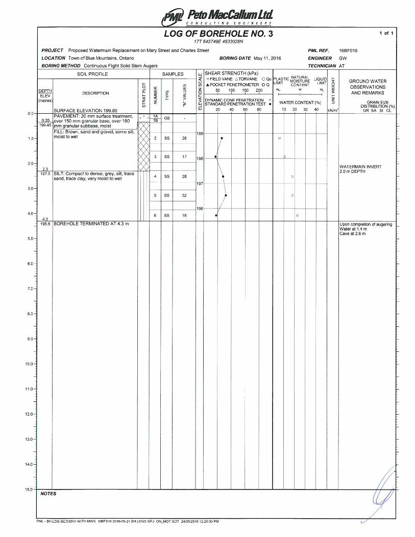
The field work for the boreholes was carried out on May 11, 2016 and consisted of three
boreholes. Borehole 1 was advanced to 6.4 m depth near the creek on Mary Street and
Boreholes 2 and 3 were advanced to 4.3 m in other areas of the watermain alignment.
Test pit and borehole locations are shown on Drawing 1.
The test pit was advanced by a rubber track backhoe under the direction of the
Town of Blue Mountains staff. The boreholes were advanced using continuous flight solid stem
augers, powered by a truck mounted CME-75 drill rig, equipped with an automatic hammer,
supplied and operated by a specialist drilling contractor, working under the full-time supervision of
a member of our engineering staff.
The pavement component thicknesses encountered in the boreholes were measured and
samples of the granular material collected. Representative samples of the underlying subgrade
soils were recovered at frequent depth intervals for identification purposes using a conventional
split spoon sampler. Standard penetration tests were carried out simultaneously with the

Proposed Watermain Replacement on Mary Street and Charles Street, Town of Blue Mountains, Ontario PML Ref.: 16BF018, Report: 1 May 26, 2016, Page 3
sampling operations to assess the strength characteristics of the subsoil. Ground water
conditions were closely monitored during the course of the field work.
The location of the test pit was established in the field by the Client. The location of each
borehole was established in the field by PML, cognizant of underground utility locates.
Surface elevations of the test pit and boreholes were established relative to a Temporary Bench
Mark (TBM), as shown on Drawing 1, and described as follows:
TBM: Top of Iron Bar at Southeast Corner of Mary Street and Charles Street Intersection Elevation 199.23 (metric, geodetic)
Traffic control was provided by PML in accordance with the Ontario Traffic Manual, Book 7. Test
pits were backfilled with excavated soils. All boreholes were backfilled and capped with cold mix
asphalt.
All recovered samples were returned to our laboratory for moisture content determination and
detailed examination to confirm field classification. Grain size analyses were carried out on four
samples of existing subgrade materials. Associated Atterberg limits testing was carried out on
one of these samples. The results are presented on Figures 1 to 4, attached.
SUMMARIZED SUBSURFACE CONDITIONS
Reference is made to the appended Log of Test Pit sheet for details of the subsurface conditions
observed in the open test pit. Reference is made to the appended Log of Borehole sheets for
details of the subsurface conditions, including soil classifications, pavement thicknesses, inferred
stratigraphy, Standard Penetration N values, ground water observations and the results of
laboratory water content determinations.
The test pit and boreholes revealed pavement or topsoil underlain by fill, over a major silt unit,
locally, underlain by a till deposit. A description of the distribution of the subsurface conditions is
presented below.

Proposed Watermain Replacement on Mary Street and Charles Street, Town of Blue Mountains, Ontario PML Ref.: 16BF018, Report: 1 May 26, 2016, Page 4
Topsoil
At the surface of Test Pit 1, a 400 mm layer of silt topsoil was encountered.
Pavement
The table below summarizes the pavement structure encountered in the boreholes:
BOREHOLE SURFACE
TREATMENT (mm)
GRANULAR BASE (mm)
GRANULAR SUBBASE
(mm)
TOTAL THICKNESS
(mm) Mary Street
1 20 110 200 330 2 20 100 110 230
Charles Street 3 20 150 180 350
Fill
Below the pavement structure or topsoil, fill was encountered in the test pit and in all boreholes to
depths of 1.5 to 2.4 m (elevation 196.7 to 197.9). The fill comprised sandy silt to sand, some silt
to sand and gravel. Three samples of the material from the boreholes were submitted for grain
size analysis and the results are presented on Figures 1 to 3, attached. The fill was moist to wet.
Moisture contents ranged from 5 to 22%.
Silt
A native silt unit was encountered below the fill in in all boreholes and in the test pit. The layer
extended to the 1.8 m depth of excavation in Test Pit 1, and carried to the 4.3 m depth of drilling
in Boreholes 2 and 3. In Borehole 1, the unit was penetrated at 5.5 m (elevation 193.3). The unit
contained trace sand and trace clay. A sample of the silt was submitted for a grain size analysis
and the results are presented on Figure 4, attached. Atterberg limits testing showed the material
was non-plastic. The unit was typically compact, locally loose or dense, with
Standard Penetration N Values (N values – blows per 300 mm of penetration of the split spoon
sampler) of 7 to 32. Moisture contents were 18 to 25%, with the material being very moist to wet.

Proposed Watermain Replacement on Mary Street and Charles Street, Town of Blue Mountains, Ontario PML Ref.: 16BF018, Report: 1 May 26, 2016, Page 5
Till
A till deposit was found below the silt in Borehole 1, extending to the 6.4 m depth of investigation.
The till comprised silty sand, with trace gravel. Cobbles and boulders were noted. The till was
very dense with moisture contents of about 9% (moist).
Ground Water
In Test Pit 1, minor seepage was noted at 1.2 m depth (elevation 198.2), however there was no
sidewall sloughing and the infiltration rate was quite slow.
Upon completion of augering, water was observed in all the boreholes at 0.8 to 1.4 m depth
(elevation 198.0 to 198.4).
Based on the above, in conjunction with the moisture content profile, it is believed that the ground
water is perched within the fill above the silt layer, with the silt layer also being wet. The creek
base at about elevation 196.0 (about 3.0 m below the road grade) and the water was about
100 mm deep at the time of our field work.
Ground water levels will fluctuate seasonally and in response to variations in precipitation.
GEOTECHNICAL ENGINEERING CONSIDERATIONS
General
The Town of Blue Mountains is proposing to replace about 450 m of watermain and service
laterals along Mary Street and Charles Street in Clarksburg. The new watermain will comprise
150 mm diameter PVC pipe and will be installed with an invert of approximately 2.0 m below
existing road grade. A small creek crosses Mary Street and the watermain invert will drop to
4.5 to 5.0 m below road grade, about 2.0 m below the creek. The portion of the watermain below
the creek will be installed with trenchless methods, so the creek is not disturbed. Once the
underground works have been completed, the roadway will be restored over the watermain
trench.

Proposed Watermain Replacement on Mary Street and Charles Street, Town of Blue Mountains, Ontario PML Ref.: 16BF018, Report: 1 May 26, 2016, Page 6
The test pit and boreholes revealed topsoil or pavement, over fill and a major silt unit, locally
underlain by a till deposit. Ground water was encountered at 0.8 to 1.4 m depth (about elevation
198.0 to 198.4) in the test pit and the boreholes.
Site Servicing
The proposed watermain will have an invert of 2.0 m below the road grade, locally deeper under
the creek (4.5 to 5.0 m) where trenchless methods are proposed for installation.
Trench Excavation and Ground Water Control
Trench excavation and ground water control for the watermain is discussed in
Excavation and Ground Water Control later in the report.
Pipe Bedding
Based on the boreholes, the subgrade at invert levels (about 2.0 m depth throughout the
alignment) is expected to comprise a thin fill layer over native silt. Where fill or other deleterious
materials are encountered at invert level, such fill should be sub-excavated and replaced with
increased bedding thickness, subject to geotechnical field review.
Standard granular bedding, in accordance with OPSS compacted to 95% Standard Proctor
maximum dry density should be satisfactory. For flexible pipes, bedding and cover material
should comprise OPSS Granular A. For rigid pipes, the bedding material should comprise
OPSS Granular A and cover material may comprise select native soil free of oversized material.
Trench Backfill
Trench backfill should be compacted to 95% Standard Proctor maximum dry density in 200 mm
thick lifts. Backfill for at least the upper 1 m of trench should be close to optimum moisture
content to prevent subgrade instability issues.
In general, excavated materials from above the ground water table are expected to be acceptable
for reuse subject to exclusion of deleterious content/organics, and geotechnical review and

Proposed Watermain Replacement on Mary Street and Charles Street, Town of Blue Mountains, Ontario PML Ref.: 16BF018, Report: 1 May 26, 2016, Page 7
approval during construction. Material from below the ground water table will have to be dried out
or mixed with drier soil to render the material suitable.
Earthworks operations should be inspected by PML to approve materials, placement and
compaction efforts and ensure the specified degree of compaction is achieved throughout.
Trenchless Watermain Installation
It is understood that the watermain will be installed beneath the existing creek crossing on
Mary Street with an invert at 4.5 to 5.0 m depth (about elevation 194.0) some 2.0 m below the
creek bed. In this regard, Horizontal Directional Drilling (HDD) is recommended, subject to the
commentary below.
Based on Borehole 1 on Mary Street, the operation will encounter compact to loose silt and be
below the creek and groundwater levels. It is noted that a very dense till deposit was contacted
below the silt and may be contacted during the operation. Cobbles and boulders were
encountered in the till and will represent possible obstacles to the trenchless operations.
It is assumed that HDD operations will be carried out from the surface and no sending-receiving
pits are required.
HDD installations should be carried out in accordance with OPSS 450,
Construction Specifications for Pipeline and Utility Installation in Soil by Horizontal Directional
Drilling.
A monitoring program to measure the vertical ground movements is recommended.
Consideration should be given to a monitoring program that follows the plan outlined in MTO’s
Guidelines for Foundation Engineering – Tunnelling Specialty for Encroachment Permit
Application, including a series of monitoring points, daily measurements, and review level and
alert levels of movement where a specific plan of action is in place for these levels of movement.

Proposed Watermain Replacement on Mary Street and Charles Street, Town of Blue Mountains, Ontario PML Ref.: 16BF018, Report: 1 May 26, 2016, Page 8
Excavation and Ground Water Control
Considering bedding thickness and potential fill removal, excavation for the watermain will extend
to about 2.5 m below the present road levels. In this regard, excavation will be carried out
through the existing pavement, fill, and into the underlying silt. Excavation within these materials
should be straightforward, and may be carried out using conventional equipment.
All construction work must be carried out in accordance with the requirements of the
Occupational Health and Safety Act (OHSA). The site soils are considered as Type 3 soil
requiring side walls to be constructed at no steeper than one horizontal to one vertical (1H:1V)
from the base of the excavation.
Ground water was observed below 0.8 to 1.4 m depth in all boreholes; however it was noted that
the ground water seepage volume in the open test pit was manageable. In this regard,
conventional sump pumping should suffice to control ground water seepage and surface water
run-off in most excavations.
Water taking in Ontario is governed by the Ontario Water Resources Act (OWRA) and the
Water Takings and Transfer Regulation O. Reg. 387/04. Section 34 of the OWRA requires
anyone taking more than 50,000 L/d to obtain a Permit to Take Water (PTTW) from the
Ministry of the Environment and Climate Change (MOECC). This requirement applies to all
withdrawals, whether for consumption, temporary construction dewatering, or permanent drainage
improvements. In April of this year the MOECC made some changes to the PTTW requirements.
Projects such as this, where creek diversion is required and/or if it assessed that less than
400,000 L/d of ground water will be taken, the Owner can apply for a permit online via the
Environmental Activity and Sector Registry (EASR) system. It is understood that under the EASR
a permit/permission to proceed, might be granted in less time than the typical three months for a
Category 3 PTTW.
Based on our current understanding of these recent changes, this project might qualify for the
new EASR system registry. Once design details are finalized the project should be reviewed to
confirm the MOECC requirements for a PTTW.
Proposed Watermain Replacement on Mary Street and Charles Street, Town of Blue Mountains, Ontario PML Ref.: 16BF018, Report: 1 May 26, 2016, Page 9
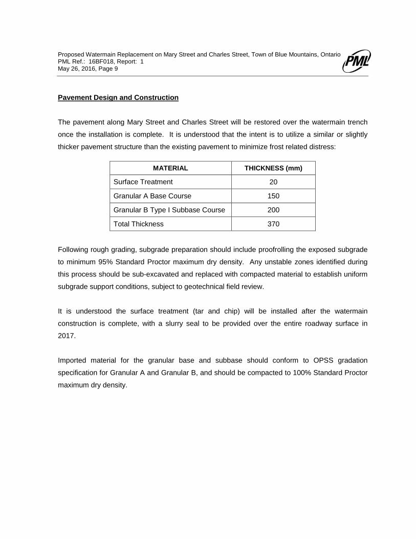
Pavement Design and Construction
The pavement along Mary Street and Charles Street will be restored over the watermain trench
once the installation is complete. It is understood that the intent is to utilize a similar or slightly
thicker pavement structure than the existing pavement to minimize frost related distress:
MATERIAL THICKNESS (mm)
Surface Treatment 20
Granular A Base Course 150
Granular B Type I Subbase Course 200
Total Thickness 370
Following rough grading, subgrade preparation should include proofrolling the exposed subgrade
to minimum 95% Standard Proctor maximum dry density. Any unstable zones identified during
this process should be sub-excavated and replaced with compacted material to establish uniform
subgrade support conditions, subject to geotechnical field review.
It is understood the surface treatment (tar and chip) will be installed after the watermain
construction is complete, with a slurry seal to be provided over the entire roadway surface in
2017.
Imported material for the granular base and subbase should conform to OPSS gradation
specification for Granular A and Granular B, and should be compacted to 100% Standard Proctor
maximum dry density.

Proposed Watermain Replacement on Mary Street and Charles Street, Town of Blue Mountains, Ontario PML Ref.: 16BF018, Report: 1 May 26, 2016, Page 10
Geotechnical Review and Construction Inspection and Testing
It is recommended that the project design drawings be submitted to PML for geotechnical review
for compatibility with site subsurface conditions and the recommendations contained in this report.
Earthworks operations should be carried out with review by PML to approve subgrade
preparation, backfill materials, placement and compaction procedures and check the specified
degree of compaction is achieved throughout fill materials.
The comments and recommendations provided in the report are based on the information
revealed in the boreholes. Conditions away from and between boreholes may vary, particularly in
view of service trenches and previous earthworks activities at the site, which may necessitate
modifications to the recommendations contained in the report.


LIST OF ABBREVIATIONS
PENETRATION RESISTANCE
Standard Penetration Resistance N: - The number of blows required to advance a standard split spoon sampler 0.3 m into the subsoil. Driven by means of a 63.5 kg hammer falling freely a distance of 0.76 m. Dynamic Penetration Resistance: - The number of blows required to advance a 51 mm, 60 degree cone, fitted to the end of drill rods, 0.3 m into the subsoil. The driving energy being 475 J per blow.
DESCRIPTION OF SOIL
The consistency of cohesive soils and the relative density or denseness of cohesionless soils are described in the following terms:
CONSISTENCY N (blows/0.3 m) c (kPa) DENSENESS N (blows/0.3 m)
Very Soft 0 - 2 0 - 12 Very Loose 0 - 4 Soft 2 - 4 12 - 25 Loose 4 - 10 Firm 4 - 8 25 - 50 Compact 10 - 30 Stiff 8 - 15 50 - 100 Dense 30 - 50 Very Stiff 15 - 30 100 - 200 Very Dense > 50 Hard > 30 > 200 WTPL Wetter Than Plastic Limit APL About Plastic Limit DTPL Drier Than Plastic Limit
TYPE OF SAMPLE
SS Split Spoon TW Thinwall Open WS Washed Sample TP Thinwall Piston SB Scraper Bucket Sample OS Oesterberg Sample AS Auger Sample FS Foil Sample CS Chunk Sample RC Rock Core ST Slotted Tube Sample
PH Sample Advanced Hydraulically PM Sample Advanced Manually
SOIL TESTS
Qu Unconfined Compression LV Laboratory Vane Q Undrained Triaxial FV Field Vane Qcu Consolidated Undrained Triaxial C Consolidation Qd Drained Triaxial
PML-GEO-508A Rev. 2004-01