Embed Size (px)
Citation preview

Jüri Roosaare (assoc.prof., University of Tartu)1
Socrates – Erasmus Summer School: Full Integration of Geodata in GIS
Geospatial analysis in GIS
Geospatial analysis in GISintegrating data
for hydrologic applications by means of ArcGIS software

Jüri Roosaare (assoc.prof., University of Tartu)2
Socrates – Erasmus Summer School: Full Integration of Geodata in GIS
Geospatial analysis in GIS
Materials for this lectureare compiled using:
Arctur, D. & Zeiler, M. 2004. Designing Geodatabases. Case Studies in GIS Data Modeling. ESRI Press, 393 ppESRI ArcGIS documentation [manuals of different versions]Maidment, D.R. (ed.) 2002. ArcHydro: GIS for Water Resources.ESRI Press, 203 pp. + CDRoosaare, J. 2004. Geoinformaatika. Kaitseväe Ühendatud Õppeasutuse õppevahend. Tartu, 172 pp. + CD

Jüri Roosaare (assoc.prof., University of Tartu)3
Socrates – Erasmus Summer School: Full Integration of Geodata in GIS
Geospatial analysis in GIS
GIS is geospatial IINFORMATION NFORMATION SSYSTEMYSTEMIS = computer system + its environment
hardwarehardwareknowknow howhow
softwaresoftware datadata
peoplepeople
infrastructureinfrastructure

Jüri Roosaare (assoc.prof., University of Tartu)4
Socrates – Erasmus Summer School: Full Integration of Geodata in GIS
Geospatial analysis in GIS
database is an organised collection of logically related datadata have to be processed to gather information
in order to increaseknowledge of users
AndmesisestusAndmesisestusAndmesisestus
AndmehaldusAndmehaldusAndmehaldus
AndmeanalüüsAndmeanalüüsAndmeanalüüsAndmeesitusAndmeesitusAndmeesitusANDMEBAASANDMEBAASANDMEBAAS
KasutajaliidesKasutajaliidesKasutajaliides
ANDMEBAASIDANDMEBAASIDANDMEBAASID
AndmesisestusData inputData input
AndmehaldusDBMSDBMS
AndmeanalüüsDataanalysis
DataanalysisAndmeesitusData
presentationData
presentation ANDMEBAASANDMEBAASANDMEBAAS
KasutajaliidesUser interfaceUser interface
ANDMEBAASIDDatabase(s)Database(s)

Jüri Roosaare (assoc.prof., University of Tartu)5
Socrates – Erasmus Summer School: Full Integration of Geodata in GIS
Geospatial analysis in GIS
Logical level(independent of software)
Reality model Conceptual (information) model
Data level(DBMS specific)
Data model
Physical data modelling
User level
Presentation models

Jüri Roosaare (assoc.prof., University of Tartu)6
Socrates – Erasmus Summer School: Full Integration of Geodata in GIS
Geospatial analysis in GIS
Reality model Conceptual (information) model
polygonslinesraster
Thematic layers (themes)– a key concept in GIS. A thematic layer is a collection of commongeographic elements. Each theme may have its own geographic representations.
......

Jüri Roosaare (assoc.prof., University of Tartu)7
Socrates – Erasmus Summer School: Full Integration of Geodata in GIS
Geospatial analysis in GIS
Data modelgeorelationalgeorelational data modeldata model
– spatial data and attributive data separately– e.g. shapefiles:
vector data for the features in binary files (.shp)attributes in a data table (.dbf)unique identifiers are used to link them to each other.
spatial data
attributivedata

Jüri Roosaare (assoc.prof., University of Tartu)8
Socrates – Erasmus Summer School: Full Integration of Geodata in GIS
Geospatial analysis in GIS
Data modelgeorelational data modelgeodatabasegeodatabase data modeldata model
– all elements are managed in standard DBMS tables using standard SQL data types
– object-basedfeatures, rasters, tables, references etc
– altogether in a container file (.mdb) as a databaseobjects can have built-in behaviour (objects encapsulation)each table stores a feature classeach feature is a row in that tablespatially large feature classes can be stored seamlessly, not tiled.

Jüri Roosaare (assoc.prof., University of Tartu)9
Socrates – Erasmus Summer School: Full Integration of Geodata in GIS
Geospatial analysis in GIS
Reality model
Conceptual (information) model
Data model
Presentation models
animationsmapsreportsforms...
Physical data modelling – a black box for the user

Jüri Roosaare (assoc.prof., University of Tartu)10
Socrates – Erasmus Summer School: Full Integration of Geodata in GIS
Geospatial analysis in GIS
ArcGIS geodatabase model datasets

Jüri Roosaare (assoc.prof., University of Tartu)11
Socrates – Erasmus Summer School: Full Integration of Geodata in GIS
Geospatial analysis in GIS
ArcGIS geodatabase model

Jüri Roosaare (assoc.prof., University of Tartu)12
Socrates – Erasmus Summer School: Full Integration of Geodata in GIS
Geospatial analysis in GIS
ArcGIS geodatabase modelArcGIS has several template data models
– census units– addresses and locations– land cadastre– transportation networks– hydrography
data on water resourcesinventory approachwater as “blood” of landscapebehavioural approach
Definitions of hydrology and hydrography are different in different scientific regions
Definitions of hydrology and hydrography are different in different scientific regions
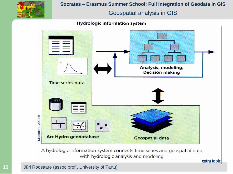
Jüri Roosaare (assoc.prof., University of Tartu)13
Socrates – Erasmus Summer School: Full Integration of Geodata in GIS
Geospatial analysis in GIS
Mai
dmen
t, 20
02:9
extra topic

Jüri Roosaare (assoc.prof., University of Tartu)14
Socrates – Erasmus Summer School: Full Integration of Geodata in GIS
Geospatial analysis in GIS
Arc Hydro data modelDivides water resources data into five components:
– Network – connected sets of points and lines showing pathways of water flow.
– Drainage – drainage areas and stream linesdefined from surface topography.
– Channel – a 3D line representation of the shape of river and stream channels.
– Hydrography – the base data fromtopographic maps and tabular datainventories.
– Time series – tabular attribute datadescribing time-varying water properties for any hydro feature
Does not describe constructedwater pipe systemsHas an associated set of tools
– to support hydrologic simulation modelling

Jüri Roosaare (assoc.prof., University of Tartu)15
Socrates – Erasmus Summer School: Full Integration of Geodata in GIS
Geospatial analysis in GIS
Feature dataset Network
Flow direction is assignedgoing downstream on the hydro network
HydroPointEventshave relative location
Streams hierarchy may be ordered in different ways(Horton’s, Strahler’s etc.)
Streams hierarchy may be ordered in different ways(Horton’s, Strahler’s etc.)

Jüri Roosaare (assoc.prof., University of Tartu)16
Socrates – Erasmus Summer School: Full Integration of Geodata in GIS
Geospatial analysis in GIS
Feature dataset DrainageDrainage areas have complex hierarchy and different definitions– to simplify– to standardise
Drainage areas have complex hierarchy and different definitions– to simplify– to standardise

Jüri Roosaare (assoc.prof., University of Tartu)17
Socrates – Erasmus Summer School: Full Integration of Geodata in GIS
Geospatial analysis in GIS
Feature dataset Drainage
Basins are set of administratively chosen drainage areas that partition a region for purposes of water resources management.Basins are normally named after the principal rivers and streams of the region.
an ArcHydro geodatabase for each basin

Jüri Roosaare (assoc.prof., University of Tartu)18
Socrates – Erasmus Summer School: Full Integration of Geodata in GIS
Geospatial analysis in GIS
Feature dataset Drainage
Watersheds are subdivision of a basin into drainage areas selected for a particular hydrologic purposes.
the same network may have different watersheds

Jüri Roosaare (assoc.prof., University of Tartu)19
Socrates – Erasmus Summer School: Full Integration of Geodata in GIS
Geospatial analysis in GIS
Feature dataset Drainage
Catchments are subdivision of a basin into elementary drainage areas defined by a consistent set of physical rules.
http:
//www
.dop.c
o.nz/f
iles/i
mage
s/GIS
.Wate
rshed
1.jpg

Jüri Roosaare (assoc.prof., University of Tartu)20
Socrates – Erasmus Summer School: Full Integration of Geodata in GIS
Geospatial analysis in GIS
Feature dataset Channel
Bridge, Dam, ..., UserPointBridge, Dam, ..., UserPoint

Jüri Roosaare (assoc.prof., University of Tartu)21
Socrates – Erasmus Summer School: Full Integration of Geodata in GIS
Geospatial analysis in GIS
Feature dataset Hydrography
Developed according to US

Jüri Roosaare (assoc.prof., University of Tartu)22
Socrates – Erasmus Summer School: Full Integration of Geodata in GIS
Geospatial analysis in GIS
Time series data
fixedvariables
points
time

Jüri Roosaare (assoc.prof., University of Tartu)23
Socrates – Erasmus Summer School: Full Integration of Geodata in GIS
Geospatial analysis in GIS
Time series data

Jüri Roosaare (assoc.prof., University of Tartu)24
Socrates – Erasmus Summer School: Full Integration of Geodata in GIS
Geospatial analysis in GIS
ID-s for featuresA data table in relational database must have the primary key – a unique IDentifier of each row (feature).In Arc Hydro, all features are hydro features and therefore have two obligatory attributes:
– HydroID – An integer attribute that uniquely identifies the feature in the geodatabase;format for HydroID: <class number><feature number>extended HydroID: <drainage area ID> <class number><feature number>
– Assign_HydroID– a tool to support automatic assignment of IDs
– HydroCode – A text attribute that is a permanentpublic identifier of the feature
to link Arc Hydro with other IS-s
2112000033
drainage area ID feature class feature number

Jüri Roosaare (assoc.prof., University of Tartu)25
Socrates – Erasmus Summer School: Full Integration of Geodata in GIS
Geospatial analysis in GIS
Relationships in data model

Jüri Roosaare (assoc.prof., University of Tartu)26
Socrates – Erasmus Summer School: Full Integration of Geodata in GIS
Geospatial analysis in GIS
Relationships in data model
HydroJunction has WaterbodyHydroJunction has Waterbody

Jüri Roosaare (assoc.prof., University of Tartu)27
Socrates – Erasmus Summer School: Full Integration of Geodata in GIS
Geospatial analysis in GIS
Arc Hydro Toolsdescription the drainage patterns of a catchmentdrainage analysis on a terrain modeldevelopment of attributes that can be useful in hydrologic modellingcomprehensive documentation (Overview, Tutorial, online Help) attached

Jüri Roosaare (assoc.prof., University of Tartu)28
Socrates – Erasmus Summer School: Full Integration of Geodata in GIS
Geospatial analysis in GIS
Arc Hydro Tools
Tools in this menu deal with processing of Digital Elevation Model (DEM). They are mostly used once in order to prepare spatial information for later use.

Jüri Roosaare (assoc.prof., University of Tartu)29
Socrates – Erasmus Summer School: Full Integration of Geodata in GIS
Geospatial analysis in GIS
Arc Hydro ToolsTools in this menu deal with watershed and subwatersheddelineation and basin characteristic determination. They operate on top of the spatial data prepared in the terrain preprocessing stage.

Jüri Roosaare (assoc.prof., University of Tartu)30
Socrates – Erasmus Summer School: Full Integration of Geodata in GIS
Geospatial analysis in GIS
Arc Hydro Tools
These tools provide functionality for generation of some of the key attributes (fields) in the Arc Hydro data model. Some of the tools require existence of a geometric network.

Jüri Roosaare (assoc.prof., University of Tartu)31
Socrates – Erasmus Summer School: Full Integration of Geodata in GIS
Geospatial analysis in GIS
Arc Hydro Tools
These tools generate or manipulate properties of geometric (hydro) network.

Jüri Roosaare (assoc.prof., University of Tartu)32
Socrates – Erasmus Summer School: Full Integration of Geodata in GIS
Geospatial analysis in GIS
Arc Hydro Tools
These are tools for management of Arc Hydro project properties.In general, they will be seldom used.

Jüri Roosaare (assoc.prof., University of Tartu)33
Socrates – Erasmus Summer School: Full Integration of Geodata in GIS
Geospatial analysis in GIS
Arc Hydro buttonstracing flow path from the selected point to the outlet following the steepest descent
delineation of watershed for a selected point:
batch point generation (as input for watershed batch processing)
assigning related IDentifier
global point delineation – merges the resulting in delineation local watershed with the Catalog Units (e.g. EDNA) polygons located upstreamtracing upstream, downstream or in both directions (e.g. to display the catchments located upstream and/or downstream from a specific junction)

Jüri Roosaare (assoc.prof., University of Tartu)34
Socrates – Erasmus Summer School: Full Integration of Geodata in GIS
Geospatial analysis in GIS

Jüri Roosaare (assoc.prof., University of Tartu)35
Socrates – Erasmus Summer School: Full Integration of Geodata in GIS
Geospatial analysis in GIS