Embed Size (px)
Citation preview

REPORT OF THEDEPARTMENT OF TRANSPORTATION ON THE
Georgetown Pike
TO THE GOVERNOR ANDTHE GENERAL ASSEMBLY OF VIRGINIA
SENATE DOCUMENT NO. 47
COMMONWEALTH OF VIRGINIARICHMOND1994
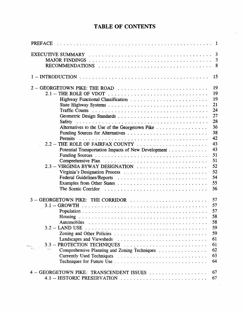
TABLE OF CONTENTS
PREFACE 1
EXECUTIVE SUMMARY 3MAJOR FINDINGS . . . . . . . . . . . . . . . . . . . . . . . . . . . . . . . . . . . . .. 3RECOMMENDATIONS 8
1 -- INTRODUCTION . . . . . . . . . . . . . . . . . . . . . . . . . . . . . . . . . . . . . . .. 15
2 -- GEORGETOWN PIKE: THE ROAD 192.1 -- THE ROLE OF VDOT . . . . . . . . . . . . . . . . . . . . . . . . . . . . . .. 19
Highway Functional Classification . . . . . . . . . . . . . . . . . . . . .'. .. 19State Highway Systems . . . . . . . . . . . . . . . . . . . . . . . . . . . . . .. 21Traffic Counts 24Geometric Design Standards. . . . . . . . . . . . . . . . . . . . . . . . . . .. 27Safety 28Alternatives to the Use of the Georgetown Pike . . . . . . . . . . . . . . .. 36Funding Sources for Alternatives . . . . . . . . . . . . . . . . . . . . . . . .. 38Permits 42
2.2 -- THE ROLE OF FAIRFAX COUNTY . . . . . . . . . . . . . . . . . . . . .. 43Potential Transportation Impacts of New Development , 43Funding Sources . . . . . . . . . . . . . . . . . . . . . . . . . . . . . . . . . .. 51Comprehensive Plan 51
2.3 -- VIRGINIA BYWAY DESIGNATION . . . . . . . . . . . . . . . . . . . . .. 52Virginia's Designation Process 52Federal Guidelines/Reports 54Examples from Other States . . . . . . . . . . . . . . . . . . . . . . . . . . .. 55The Scenic Corridor 56
3 -- GEORGETOWN PIKE: THE CORRIDOR 573.1 -- GROWTH . . . . . . . . . . . . . . . . . . . . . . . . . . . . . . . . . . . . . .. 57
Population. . . . . . . . . . . . . . . . . . . . . . . . . . . . . . . . . . . . . .. 57Housing . . . . . . . . . . . . . . . . . . . . . . . . . . . . . . . . . . . . . . .. 58Automobiles 58
3.2 -- LAND USE . . . . . . . . . . . . . . . . . . . . . . . . . . . . . . . . . . . . .. 59Zoning and Other Policies . . . . . . . . . . . . . . . . . . . . . . . . . . . ., 59Landscapes and Viewsheds 61
3.3 -- PROTECTION TECHNIQUES 61Comprehensive Planning and Zoning Techniques . . . . . . . . . . . . . .. 62Currently Used Techniques 63Techniques for Future Use . . . . . . . . . . . . . . . . . . . . . . . . . . . .. 64
4 -- GEORGETOWN PIKE: TRANSCENDENT ISSUES . . . . . . . . . . . . . . . . .. 674.1 -- HISTORIC PRESERVATION. . . . . . . . . . . . . . . . . . . . . . . . . .. 67

VirginiafNational Register Listing 67Effects of Eligibility -- Preservation Laws 71Preservation Funding . . . . . . . . . . . . . . . . . . . . . . . . . . . . . . .. 73
4.2 -- SAFETY AND TORT LIABILITY. . . . . . . . . . . . . . . . . . . . . . .. 76Description of Tort Liability. . . . . . . . . . . . . . . . . . . . . . . . . . .. 76Tort Liability and Road Design Factors . . . . . . . . . . . . . . . . . . . .. 77Risk Management ... . . . . . . . . . . . . . . . . . . . . . . . . . . . . . .. 79Historic Preservation Laws 79
5 -- CONCLUSION AND RECOMMENDATIONS . . . . . . . . . . . . . . . . . . . . .. 83
NOTES 89
APPENDICES . . . . . . . . . . . . . . . . . . . . . . . . . . . . . . . . . . . . . . . . . . . .. 97A. Functional Classification Definitions . . . . . . . . . . . . . . . . . . . . . . . .. 97B. Criteria for Transferring Secondary Roads to the Primary System . . . . . .. 98C. Accident Analysis Figures . . . . . . . . . . . . . . . . . . . . . . . . . . . ',' .. 99D. Criteria for Designation as a Virginia Byway 117E. Federal Guidelines: The Scenic Corridor. . . . . . . . . . . . . . . . . . . .. 118F. Historic Corridor Ordinance and Enabling Legislation . . . . . . . . . . . .. 120G. Section 106 of the National Historic Preservation Act of 1966 . . . . . . .. 121H. The Section 106 Process: Evaluating Effects . . . . . . . . . .. 122I. Section 4(f) of the Department of Transportation Act of 1966 . . . . . . . .. 123J. National Environmental Policy Act of 1969 . . . . . . . . . . . . . . . . . . .. 124K. Joint Resolutions. . . . . . . . . . . . . . . . . . . . . . . . . . . . . . . . . . .. 125L. Work Plan 127M. Public Hearing 128

FIGURES
1-1. The Georgetown Pike Corridor, Fairfax County, Virginia. . . . . . . . . . . . .. 16
2-1. Georgetown Pike 24-Hour Traffic Volumes at Selected Locations . . . . . . . .. 25
2-2. Georgetown Pike Peak-Hour Traffic Volumes at Selected Locations 26
C-l. Total Number of Accidents per Year 99
C-2. Number of Injury and Property Damage Accidents per Year 100
C-3. Number of Fatal Accidents per Year ' 101
C-4. Percentage of Accidents by Collision Types 102
C-5. Type of Fixed Objects Hit in Accidents . . . . . . . . . . . . . . . . . . . . . . . . . 103
C-6. Percentage of Accidents Occurring by Surface Condition . . . . . . . . . . . . . . 104
C-7. Percentage of Accidents by Hour of Occurrence 105
C-8. Number of Accidents per Year at Intersection of Old Dominion Drive 106
C-9. Number of Accidents per Year at Intersection of River Bend Road ... . . . . . 107
C-IO. Suggested Positive Barrier to Decrease Accident Occurrence at theIntersection of River Bend Road . . . . . . . . . . . . . . . . . . . . . . 108
C-ll. Number of Accidents per Year at Intersection of Swinks Mill Road 109
C-12. Number of Accidents per Year at Intersection of Harvey Road 110
C-13. Number of Accidents per Year at Intersection of Route 7 . . . . . . . . . . . . . . 111
C-14. Number of Accidents per Year at Intersection of Douglas Drive 112
C-15. Number of Accidents per Year at Intersection of Mackall Avenue 113
-C-16. Number of Accidents per Year at Intersection of the Ramp fromEB Georgetown Pike to NB 1-495 .. 114
C-17. Number of Accidents per Year at Intersection of Springvale Road 115
C-18. Predicted Accident Reduction by Shoulder Widening on Two-Lane Roads .... 116

TABLES
2-1. Sites with Greater Than 40 Accidents . . . . . . . . . . . . . . . . . . . . . . . . .. 31
3-1. Population . . . . . . . . . . . . . . . . . . . . . . . . . . . . . . . . . . . . . . . . . . . 57
3-2. Housing 58
3-3. Minimum Number of Vehicles Available in the Georgetown Pike Corridor . .. 59

pREFACE
House Joint Resolution No. 411 (HJR 411) and Senate Joint Resolution No. 235 (SJR235) requested that the Virginia Department of Transportation (VDOT) study specifiedpreservation issues concerning the Ceorgetown Pike (Route 193) in Fairfax County, Virginia,and report its findings to the Governor and the 1994 General Assembly.
Gerald E. Fisher, a Research Scientist at the Virginia Transportation ResearchCouncil, was designated to lead this study. The study team included Richard V. Taylor, wholed the research and writing of the report, and Philomena B. Lockwood, who assisted withthe research, analysis, and writing on accidents and the effects of development ontransportation in Fairfax County.
The study team thanks the following people for their extraordinary assistance with thisstudy: Senator Janet D. Howell and Delegate Vincent F. Callahan, especially for theirparticipation at the Public Hearing; Fairfax County Dranesville District Supervisor Ernest J.Berger; Elizabeth David and Bruce Kriviskey, our contacts with Fairfax County's HeritageResources Branch; Chuck Almquist, Sam Chamberlain, Paul Eno, Kathy lehter, EdJankiewicz, Colleen Karmol, Dennis King, Wayne Pumphrey, and John Winfield with theFairfax County Government; Tanya Beauchamp, preservation consultant to Fairfax County;John J. Adams and all the citizens and organizational representatives who wrote comments orspoke at the Public Hearing on August 5, 1993; Hugh Miller, Julie Vosmik, and ElizabethHoge with the Virginia Department of Historic Resources; and Art Buelher and Derral Joneswith the Virginia Department of Conservation and Recreation.
From VDOT's Central Office: Phil Baker, William A. Brown, Lynwood Butner,Claude D. Garver, Jr., David R. Gehr, Jack Hodge, Gene Martin, Margaret Redford, LeoRutledge, Carl Sheets, Mary Lynn Tischer, Gerald Venable, and Cooper Wamsley. FromVDOT's Northern Virginia District: Jim Cromwell, Otis Deal, Frank Edwards, Thomas F.Farley, Bill Jones, Noreen Maloney, Bill Mann, David Ogle, Bill Thomas, Tom Walker, andGary Yowell. From VDOT's Fairfax Residency: Kaye Braxton and Young Ho Chang.From, VDOT's Richmond District: Jerry Moore.
From the Virginia Transportation Research Council: Gary R. Allen, AngelaAndrews, Gene Arnold, Steve Blackwell, Bob Borhart, Tina Briganti, Randy Combs, BenCottrell, Eileen Dieck, Linda Evans, Wayne Ferguson, Jerry Garrison, Roger Howe, JanKennedy, Mike Perfater, and Jennifer Ward.
1

2

EXECUTIVE SUMMARY
Raising public awareness of the history of the Georgetown Pike, in order to preservethe road's historic character, has long been a goal of citizens and Fairfax County officials.The road was designated as the Commonwealth's first Virginia Byway in 1974. Since thattime, growth along the road and in other parts of Northern Virginia has resulted in asignificant increase in traffic. A proposed widening of a portion of the road to four laneswas canceled in 1979 due to public opposition.
There is continuing public opposition to safety and capacity improvements (e.g.,deceleration lanes) proposed by Virginia Department of Transportation (VDOT) engineers tohelp manage traffic at new subdivision street entrances. For this reason, the 1993 GeneralAssembly directed VDOT to reexamine this subject. '
Pursuant to House Joint Resolution No. 411 (HJR 411) and Senate Joint ResolutionNo. 235 (SJR 235) (1993), VDOT examined issues concerning the preservation of thehistoric, cultural, and scenic nature of the Georgetown Pike (Route 193) in Fairfax County.VDOT identified existing standards, regulations, and statutes as well as alternatives to thesethat could be used in preserving the Georgetown Pike.
VDOT designated a team at the Virginia Transportation Research Council to researchand write this study. The study team accomplished this through (1) meetings with FairfaxCounty officials and citizens; VDOT Central Office, Northern Virginia District, and FairfaxResidency staff; and Virginia Department of Historic Resources and Virginia Department ofConservation and Recreation staff; (2) comments received at a public hearing held in FairfaxCounty; and (3) written comments from other interested parties. Research of statutes,regulations, processes, and standards identified by various officials was conducted, andspecial traffic counts on the Georgetown Pike were taken.
MAJOR FINDINGS
1. Basic Configuration
The Georgetown Pike does not now eonfonn to state and national design standardsregarding pavement width, shoulder width, and horizontal and vertical alignment for ahighway of its functional classification and traffic volumes.
__ Earlier attempts to widen the road to a four-lane facility were vigorously resisted, andihe Highway Commission (now the Commonwealth-Transportation Board) adopted aresolution in 1979 that the road would remain a two-lane facility. This remains the positionof the Board and of VDOT . However , tum lanes added to accommodate new developmentare viewed by some as widening the road.
3
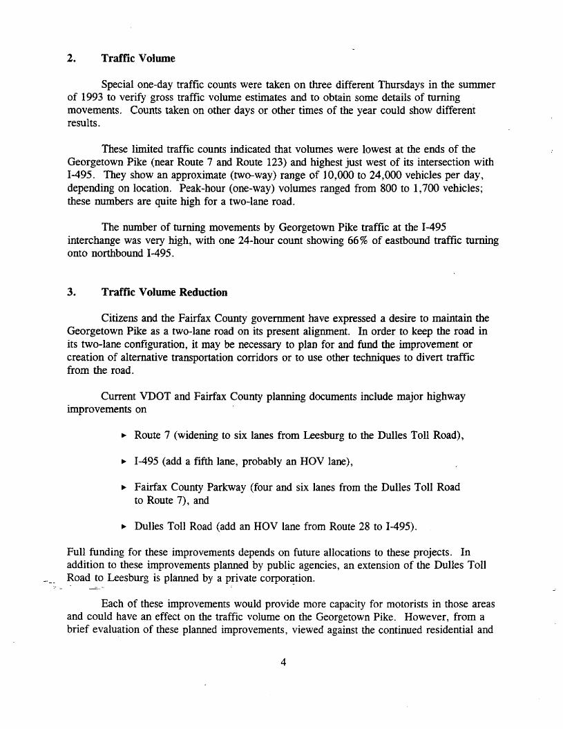
2. Traffic Volume
Special one-day traffic counts were taken on three different Thursdays in the summerof 1993 to verify gross traffic volume estimates and to obtain some details of turningmovements. Counts taken on other days or other times of the year could show differentresults.
These limited traffic counts indicated that volumes were lowest at the ends of theGeorgetown Pike (near Route 7 and Route 123) and highest just west of its intersection with1-495. They show an approximate (two-way) range of 10,000 to 24,000 vehicles per day,depending on location. Peak-hour (one-way) volumes ranged from 800 to 1,700 vehicles;these numbers are quite high for a two-lane road.
The number of turning movements by Georgetown Pike traffic at the 1-495interchange was very high, with one 24-hour count showing 66% of eastbound traffic turningonto northbound 1-495.
3. Traffic Volume Reduction
Citizens and the Fairfax County government have expressed a desire to maintain theGeorgetown Pike as a two-lane road on its present alignment. In order to keep the road inits two-lane configuration, it may be necessary to plan for and fund the improvement orcreation of alternative transportation corridors or to use other techniques to divert trafficfrom the road.
Current VDOT and Fairfax County planning documents include major highwayimprovements on
.. Route 7 (widening to six lanes from Leesburg to the Dulles Toll Road),
.. 1-495 (add a fifth lane, probably an HOV lane),
.. Fairfax County Parkway (four and six lanes from the Dulles Toll Roadto Route 7), and
.. Dulles Toll Road (add an HOV lane from Route 28 to 1-495).
Full funding for these improvements depends on future allocations to these projects. Inaddition to these improvements planned by public agencies, an extension of the Dulles Toll~oad to Leesburg is planned by a private corporation.
Each of these improvements would provide more capacity for motorists in those areasand could have an effect on the traffic volume on the Georgetown Pike. However, from abrief evaluation of these planned improvements, viewed against the continued residential and
4
commercial development in Fairfax and Loudoun Counties, it appears that none of themalone, nor all of them together, is likely to have a significant, long-term effect in reducingtraffic volumes on the Georgetowr.. Pike.
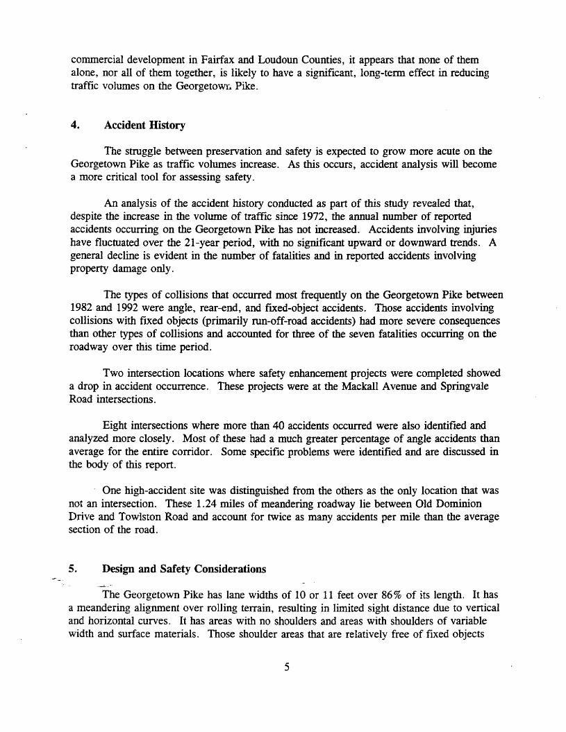
4. Accident History
The struggle between preservation and safety is expected to grow more acute on theGeorgetown Pike as traffic volumes increase. As this occurs, accident analysis will becomea more critical tool for assessing safety.
An analysis of the accident history conducted as part of this study revealed that,despite the increase in the volume of traffic since 1972, the annual number of reportedaccidents occurring on the Georgetown Pike has not increased. Accidents involving injurieshave fluctuated over the 21-year period, with no significant upward or downward trends. Ageneral decline is evident in the number of fatalities and in reported accidents involvingproperty damage only.
The types of collisions that occurred most frequently on the Georgetown Pike between1982 and 1992 were angle, rear-end, and fixed-object accidents. Those accidents involvingcollisions with fixed objects (primarily run-off-road accidents) had more severe consequencesthan other types of collisions and accounted for three of the seven fatalities occurring on theroadway over this time period.
Two intersection locations where safety enhancement projects were completed showeda drop in accident occurrence. These projects were at the Mackall Avenue and SpringvaleRoad intersections.
Eight intersections where more than 40 accidents occurred were also identified andanalyzed more closely. Most of these had a much greater percentage of angle accidents thanaverage for the entire corridor. Some specific problems were identified and are discussed inthe body of this report.
One high-accident site was distinguished from the others as the only location that wasnot an intersection. These 1.24 miles of meandering roadway lie between Old DominionDrive and Towlston Road and account for twice as many accidents per mile than the averagesection of the road.
5. Design and Safety Considerations
The Georgetown Pike has lane widths of 10 or 11 feet over 86 % of its length. It hasa meandering alignment over rolling terrain, resulting in limited sight distance due to verticaland horizontal curves. It has areas with no shoulders and areas with shoulders of variablewidth and surface materials. Those shoulder areas that are relatively free of fixed objects
5
(utility poles, trees, etc.) often drop off from the road so steeply that recovery of a vehiclethat has run off the road would be difficult.
The most serious flaw of the Georgetown Pike is the lack of adequate shoulders. Theroad has been widened throughout its history so that the pavement now reaches the ditches.This condition presents many problems.
Due to the lack of adequate shoulders, an accident or a disabled vehicle may block theroad for an extended period of time, and police, fire, and rescue personnel have few safeplaces to position vehicles for emergency response situations. Speed limit enforcement isalso hampered.
There are many run-off-road accidents involving fixed objects where an increasedclear zone would provide an opportunity for drivers to recover control of vehicles. VDOTmaintenance personnel have nowhere to push snow off the road, yet keeping the road open isa high priority for the citizens using it.
The lack of shoulders or other safe stopping places makes the road very demandingfor drivers, and especially for tourists.
An analysis of possible shoulder widening indicated that adding six feet of unpavedshoulders to each side of the road would yield as much as a 35 % reduction in nonintersectionaccidents.
6. Eligibility for Listing in the National Register
The Virginia Department of Historic Resources' (VDHR) recent designation of theroad as eligible for listing in the National Register of Historic Places is the first suchdesignation in the Commonwealth of any road without limited access, and it is the firstdesignation of any road under VDOT control. Such designation could affect the design ofany improvements to the road that are financed with federal funds. The operational andmaintenance implications of the designation are not yet clear.
However, such a designation does not exempt VDOT from its responsibility toprovide safe highways for the citizens of the Commonwealth. Further, it is not deemedsufficient to protect the right-of-way alone; without protection of the corridor surrounding theroadway, the Georgetown Pike could lose much of its remaining integrity, and itsdevelopment would further stress the road's ability to function safely.
7. Accommodating Growth
Fairfax County has applied protective measures to the Georgetown Pike corridorthrough its zoning and subdivision powers, and one historic district has been created.
6

However, development of adjacent land continues, primarily in single-family residentialsubdivisions.
In the census tracts adjoining the Georgetown Pike, U.S. Census data indicate thatbetween 1970 and 1990, the population increased by 115%, the number of housing unitsincreased by 229 %, and the number of vehicles increased by 234 %.
The continuing connection of new subdivision street entrances onto a highway withmore traffic than it can easily manage has led VDOT to request right-tum and left-tum lanesand tapers to maintain traffic flow and safety. Some citizens believe that VDOT engineersare requiring "unnecessary" changes.
8. Statute, Policy, and Regulation
VDOT engineers, often criticized by citizens elsewhere in Northern Virginia forfailing to plan for ever-growing traffic volumes, respond by attempting to accommodate newsubdivision street entrances without significantly endangering or slowing existing traffic.Measures to accomplish this include tum lanes and tapers, as well as other localimprovements.
In the Northern Virginia District, which includes all of Fairfax County, VDOTemploys the highway entrance standards appropriate for urban areas. In more rural areas ofthe Commonwealth, lower entrance standards are employed.
There are no provisions in statute or policy that authorize VDOT engineers to givepriority to historic or scenic values over the safety, comfort, and convenience of the public.Nor are there provisions to protect VDOT employees from charges of negligence should theywaive accepted design standards -- in the interest of historic preservation -- and accidentsresult. Finally, there is no provision stating that drivers of the Georgetown Pike shouldexpect to find less than customary highway design and safety features.
9. Virginia Byway Designation and Tourism
The designation of the Georgetown Pike as a Virginia Byway in 1974 and itsincorporation in state and county maps as a byway are actions intended to encourage visitorsto tour the corridor. There were valid reasons for the designation, and there are still validreasons for tourists to visit.
~ However, the road has almost no provisions.for visitors. There are narrow or no'shoulders along much of its length; there are few pull-offs for enjoying points of historic orscenic interest; and there are few places where pedestrians, equestrians, or cyclists can safelyenjoy the surroundings.
7

Although there are parks and other attractions along it, the narrow road and its heavytraffic can be hostile to casual visitors, who are forced to concentrate on maneuvering safelythrough curves and traffic, rather than enjoying the scenery.
The Georgetown Pike is designated as a Virginia Byway and is listed as such on theofficial state transportation map and on the Fairfax County historical tour map. Continuedencouragement for tourists to visit the Georgetown Pike is a questionable public policy unlessreasonable provisions are made for their safety and enjoyment.
These findings, as well as the comments of citizens, local officials, VDOT staff, andother state agency staff, led the study team to recommend that the following actions be takento preserve the Georgetown Pike without reducing safety.
RECOMMENDATIONS
During the course of this study, the right-of-way of the Georgetown Pike wasdesignated by VDHR as eligible for listing in the National Register of Historic Places. Noother VDOT-maintained highway has been so designated. Accordingly, issues concerningthis designation were incorporated into this study.
In the field of historic preservation, there are several treatment philosophies for thepreservation of a historic property, depending on the circumstances and uses of the property.Of the major options available, it is recommended that "rehabilitation" be the acceptedtreatment philosophy for the Georgetown Pike.
Rehabilitation acknowledges the possibility that a historic property still in active usemay require alteration or addition to meet continuing or changing uses while retaining itsessential historic character. The essential historic characteristics of the Georgetown Pike areits location and its meandering alignment over rolling terrain.
The following specific recommendations are offered.
1. Configuration of the Georgetown Pike
A. The Traveled Way
-Since 1979, it has been the position of the Commonwealth Transportation Board thatthe Georgetown Pike remain a two-lane facility. The traffic volume on this road wouldnormally indicate a need to widen it to four lanes, at least in some locations. However,there is a strong consensus among persons interested in historic preservation that such
8

widening is not desirable. Angle and rear-end collisions, the most common types ofaccidents on the Georgetown Pike, are not associated with inadequate road width, but aremore typically the result of inadequate intersection design.
For these reasons, it is recommended that maintaining a good two-lane roadway, inits current location, continue to be the position of the Commonwealth Transportation Boardand VDOT, Fairfax County, and VDHR. No general widening, realignment, or relocation ofthe traveled portion of the road is recommended, except as provided below.
B. The Roadside
The inadequate shoulders of the Georgetown Pike cannot be ignored. Due to a lackof shoulders, an accident or a disabled vehicle may block the road for extended periods, andpolice, fire, and rescue personnel have few safe places to position vehicles for emergencyresponse situations. Speed limit enforcement is also hampered. VDOT maintenancepersonnel have nowhere to push snow off the road, yet keeping the road open is a highpriority for citizens who use it.
Because there are many run-off-road accidents involving fixed objects, an increasedclear zone would provide an opportunity for drivers to recover control of vehicles.
It is strongly recommended that plans be developed to improve the shoulders of theroad. In lieu of conventional paved shoulders, it is recommended that planning beundertaken by VDOT and Fairfax County, in cooperation with VDHR, to provide parkwaylike grass-covered aggregate and soil shoulders along both sides of the road.
Such grass shoulders would provide many of the safety benefits of paved shoulders,would be more attractive, would discourage their use as alternate travel lanes, yet wouldprovide sufficient support for occasional vehicular use. Analysis indicates that adding sixfeet of grass shoulders to each side of the road could yield as much as a 35% reduction innonintersection accidents.
In planning for shoulder widening, these related roadside provisions should beincluded:
~ Pull-offs for tourist use to be provided at areas of unusual scenic or historic value(very important in making the road tourist-friendly);
~ Landscape plans for planting selected native tree species behind the relocated ditches(to maintain the character of the corridor past the life expectancy of existing mature
.vegetation and well into the twenty-second century); and
~ A path for cyclists and pedestrians, preferably separated from the road (this is not asimportant as pull-offs and tree planting but may also be desirable).
9
Partial funding of the design and implementation of these nonshoulder improvementsmay be available through the enhancement provisions of ISTEA.
c. Spot Safety Improvements
Periodic analysis of accidents occurring on the Georgetown Pike should be continuedto insure the early identification of safety problems. The accident history should also beused by decision-makers to determine the most appropriate entrance treatments for specificconditions.
Specific locations are identified in this report, and will continue to be identifiedthrough regular analyses of accident data, where spot improvements will be required toreduce localized hazards to the traveling public. All parties must recognize that such spotimprovements will be needed and that their design must be undertaken in a way to minimizethe adverse effects of these improvements on the character of the roadway.
Where controversies arise over the design of a particular improvement, it is,recommended that mediation, which has been used successfully in Virginia for some roadimprovements, be considered for use in the design process.
2. Street Entrances
It is recognized that the connection of new subdivision street entrances (and themeasures that provide for safe turning movements at these new intersections) creates strongopposition from many citizens. It is recommended that several actions be taken to minimizethe number and the adverse effects of new entrances, in the priority order listed below.
A. Alternate Access
Where feasible, it is recommended that Fairfax County and VDOT work together toensure that new subdivisions have no direct access to the Georgetown Pike but connectinstead to existing secondary roads in the area.
B. Joint Access
Where new subdivision street entrances are unavoidable, it is recommended thatFairfax County and VDOT take strong measures to minimize the number of new entrances, byrequiring joint entrances, by requiring that new subdivisions accommodate the future accessneeds of adjacent undeveloped lands, and by using any other appropriate means.
-c. Rural Entrance Standards
Because some new subdivisions will have no other lawful access, new entrances to theGeorgetown Pike will be required. However, as shoulders are widened, intersection sight
10

distance will improve. Therefore, the need for deceleration lanes and tapers for such streetentrances should be reduced.
Provided the Fairfax County Board of Supervisors so requests, and provided thatVDHR formally concurs, it is recommended that VDOT engineers, where a minimum stoppingsight distance of 300 feet is available or can be provided at no cost to the Commonwealth,adhere to VDOT's Minimum Standards for Entrances to State Highways 0989 edition) fornew entrances to the Georgetown Pike.
This document, intended primarily for application for rural highways, is consideredinadequate for use in urban areas such as Northern Virginia, where higher entrance standardsare employed. In consideration of Fairfax County's desire to maintain the road's existingcharacter, and in consideration of VDHR's designation of this road as eligible for listing inthe National Register of Historic Places, it is recommended that VDOT engineers recognizeand employ these "rural" standards on this road, on a trial basis.
This change would require most new cul-de-sac subdivision streets serving fewer than30 residential units (which is believed to include most subdivision activity in the area) tohave only an entrance radius, with no right-tum deceleration lane or taper.
VDOT's engineers, concerned for public safety and traffic capacity, prefer higherstandards. They have not recommended this course of action, nor have they recommendedagainst it. However, with a formal request from the Fairfax County Board of Supervisors toinitiate this change, and with formal concurrence of VDHR, VDOT could accede to thewishes of these governmental agencies on a trial basis, for this road only.
However, should accident or other information show that the application of theseminimum standards led to safety or other traffic problems, their application should bediscontinued at the discretion of VDOT's Northern Virginia District Administrator.
D. Existing Entrances
Earlier evaluation of entrances resulted in a 1979 recommendation by the VirginiaDepartment of Highways, and supported then by the Georgetown Pike and Potomac RiverAssociation, that the entrance from Langley Lane to the Georgetown Pike be closed.
Although the major construction project proposed at that time was dropped, thisminor street, with its very limited sight distance, is still a problem entrance. It is
"<recommended that Fairfax County, with the cooperationof vlnrl', give strongconsiderationto closing or abandoning the Langley Lane entrance.
11

3. The Corridor
Fairfax County has requested, and VDHR has concurred, that only the right-of-way ofthe Georgetown Pike be designated as eligible for listing in the National Register of HistoricPlaces. Some observers of this process note that, while preservation of the right-of..way mayserve a useful purpose, the roadway structure is not very historic. Instead, it is a mid..twentieth-century adaptation of what probably began as an animal trail.
The preservation of the road itself does little to preserve the scenic characteristics ofthe corridor, which include the public and private properties within view of the road.Without action to preserve and protect these lands, all that might remain of the scenic andhistoric Georgetown Pike could be the roadway's lay on the land.
The preservation of private lands is much more difficult than the preservation of landsowned by public agencies. However, as these lands continue to develop, the accommodationof increased traffic volumes and increased turning movements will continue to modify theGeorgetown Pike's roadway. .
It is recommended that Fairfax County, in cooperation with VDHR, seriously consideradditional corridor protection schemes that would control and preserve the views along thecorridor. Only by preserving the scenic qualities of the land is preservation of the roadlikely to succeed.
4. Alternative Transportation Corridors
Current VDOT and Fairfax County plans include highway improvements on:
~ Route 7 (widening to six lanes from Leesburg to the Dulles Toll Road);
~ Interstate 495 (adding a fifth lane, most likely an HOV lane);
~ Fairfax County Parkway (widening to four and six lanes from the Dulles TollRoad to Route 7); and
~ Dulles Toll Road (adding an HOV lane from Route 28 to 1-495).
In addition to these improvements planned by public agencies, an extension of the DullesToll Road to Leesburg is scheduled for construction by a private corporation.
-Bach of these improvements would improve-conditions for motorists in the affectedareas and could have an effect on traffic volume on the Georgetown Pike. However, from abrief evaluation of these planned improvements viewed in the context of the continuedresidential and commercial development in western Fairfax and Loudoun Counties, it appears
12

that none of them alone, nor all of them together, is likely to have a significant, long-termeffect in reducing traffic on the Georgetown Pike.
It is recommended that Fairfax County, VDOT, and the Virginia Department of Railand Public Transportation continue to examine alternatives for improving highways, transit,and ridesharing opportunities and to work to broaden the acceptance of telecommuting as analternative to commuting.
5. The Administrative System
Suggestions have been made that the Georgetown Pike be transferred from thePrimary System to the Secondary System of State Highways to provide opportunities forrestricting through-truck traffic or to limit other traffic.
Historically, this road was designed and constructed for commercial hauling betweenLeesburg and the port of Georgetown. For most of its considerable history, the road servedprimarily for the mobility of through traffic, and only in the past few decades has access tolocal lands become a significant traffic volume factor.
Route 193 is functionally classified as a rural major collector (west of Bullneck Run)and as an urban minor arterial to its eastern end. It meets criteria for a primary highway,and it accommodates a traffic volume upwards of 20,000 vehicles per day.
It is not appropriate. either from a historical perspective or from the perspective oftoday's transportation needs, that through traffic be restricted. It is recommended that theroad remain in the primary system.
As this report was given to VDOT to write, it is important to recognize that whilemany of the objections raised over the years to work done by VDOT on the GeorgetownPike are legitimate from a preservation standpoint, the question of safety is not. One of themajor reasons for government in the United States is to protect the health, safety, andwelfare of its citizens. Certain safety measures need to be taken on the Georgetown Pike tocreate a safer environment for citizens who use the road. However, as VDOT CommissionerRay D. Pethtel wrote in the June 1993 issue of VDOT's newspaper, Bulletin:
Cultural resources are integral to our environment here in Virginia, and VDOTis playing a great role in preserving them for posterity, while we remaincommitted to providing the safest, most efficient transportation networkpossible. 1
.
13

14
CHAPTER 1 -- INTRODUCTION
The Georgetown Pike has a long history as a transportation corridor. The path alongwhich it lies today is said to have begun as a trail carved out of the forest by animals. Later,Native Americans picked up this trail and used it to access the Potomac River below theLittle Falls. When settlers came to the area, the trail was used as a rolling road, withhogsheads of tobacco rolled to awaiting ships for transport abroad. From 1813, when thefirst portion of the road was chartered, until 1934, the road served as a toll road undervarious names -- most notably the Georgetown-Leesburg Pike. One of the private toll roadcompanies built the road in its present configuration in 1920. In 1934, the Madeira School(which is located on the Georgetown Pike) purchased the road from a private toll roadcompany and turned it over to the state, which placed the road in the secondary road system.In May 1948, the Georgetown Pike was transferred to the Primary System of State Highwaysat the request of Fairfax County officials.'
On June 20, 1974, the Commonwealth Transportation Board (CTB) designated theGeorgetown Pike as the first Virginia Byway. Throughout the 1970s and 1980s, the areasurrounding the Pike saw great development pressure and population growth, which sent newcars onto the road and changed the scenic character of its corridor. This growth, combinedwith transportation planning and safety concerns, led to the emergence of a number of issuesregarding conflicts between the preservation of the road and the necessity for safetyimprovements for the growing number of drivers using it.
Most of these issues surfaced at public hearings where improvements to theGeorgetown Pike proposed by the Virginia Department of Transportation (VDOT) werepresented. The major issues found in writing this study were identified by VDOT staff,Fairfax County officials, and citizens. The major issues and the project(s) that led to theiridentification were as follows (see Figure 1-1):
~ "Projects that include the addition of lanes or the widening of the road couldadversely impact the historic character of the road." A project to expand a section
, of the road to four lanes from the Beltway east for approximately one mile, whichwas first proposed in 1977, was never built due to opposition from citizens andcounty officials. Some vertical curves were corrected for better sight distance.
~ "The choice and design of proposed changes to the road are not always sensitive tothe historic character of the road and its corridor." A project to widen Chain BridgeRoad and Route 193 at Langley Forks in the late 1950s was challenged by citizens
.ana was resolved by building a Route 123 "bypass" to the east of what is now OldChain Bridge Road. Around 1987, another realignment at the Langley Forksintersection was proposed to improve sight distance. The cut and fill required onthese vertical curves would have affected historic structures and very old boxwoodalong the road. Through many meetings and much compromise, the road wasrealigned without damaging the boxwood or the relationship of the historic structures
15
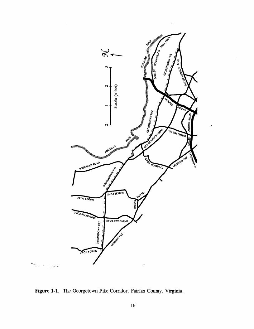
Figure 1-1. The Georgetown Pike Corridor, Fairfax County, Virginia.
16

to the roadway. The Langley Forks area was declared a Historic District, listed inthe National Register of Historic Places, and placed in a historic overlay district byFairfax County between 1980 and 1982.
... "Projects proposed in the name of safety disrupt the special character of the road. II
This relates to the rolling character of the road and safety improvements that reducedvertical curves for better sight distance. Projects on Utterback Store Road and LeighMill Road in 1986, Mackall Avenue in 1987, and Springvale Road in 1989 reducedvertical curves at intersections with the Georgetown Pike to improve safety and sightdistance.
... "Deceleration, acceleration, and turning lanes degrade the historic character of theroad and are a means of widening the road. II VDOT standards require that,manynew entrances to Route 193 include right-hand or left-hand turn and/ordeceleration/acceleration lanes. The Thistle Hill subdivision -- for which VDOTengineers felt a 250-foot deceleration lane was necessary -- was allowed to have onlya 60-foot taper. This compromise was worked out by VDOT, citizens, and localofficials.
... As a result of these conflicts, citizens and county officials have been searching forways of protecting the Georgetown Pike from improvements that would degrade thehistoric character of the road. The ways identified by citizens and county officialsincluded historic designation of the road and its VDOT-held right-of-way, userestrictions, and a change of highway systems. An Ad Hoc Committee to PreserveGeorgetown Pike was organized to identify these measures.
Concern over these issues led local citizens, county officials, and state legislators from theGeorgetown Pike area to initiate the legislation that led to this study report.
This report is organized to identify problems and possible solutions to the many issuesraised concerning the Georgetown Pike. According to the joint resolutions, VDOT wasdirected to study the following:
1. Identification of all statutory, regulatory, or published engineering,construction, traffic, or safety standards that may be inconsistent with thepurpose of maintaining the existing or historic character of this byway;
2. Identification and recommendation of alternatives to any engineering, legal, orother requirements of standards that, if followed, would degrade the aesthetic,natural, or historic character of the Jieorgetown Pike;
3. Identification of sources of funding available for preservation or improvementsto alternative transportation corridors including those sources available underISTEA (the Intermodal Surface Transportation Efficiency Act of 1991) and theNational Historic Preservation Act of 1966; and
17

4. A study of ISTEA, especially the environmental programs and provisions ofthe act, as well as programs developed by the states of Maryland, Delaware,and Pennsylvania pursuant to ISTEA, in determining what alternatives andoptions may be available.
From these major issues and the issues referred to in the resolutions, the followingorganization of the report was created:
Chapter 2 -- Issues Dealing with the Georgetown Pike as a RoadSection 2.1 -- The Role of VDOTSection 2.2 -- The Role of Fairfax CountySection 2.3 -- Virginia Byway Designation
Chapter 3 -- Issues Dealing with the Georgetown Pike CorridorSection 3.1 -- GrowthSection 3.2 -- Land UseSection 3.3 -- Protection Techniques
Chapter 4 -- Transcendent IssuesSection 4.1 -- Historic PreservationSection 4.2 -- Safety and Tort Liability
18
CHAPrER 2 - GEORGETOWN PIKE: THE ROAD
SECTION 2.1 -- THE ROLE OF VDOT
The issues surrounding the Georgetown Pike (Route 193) in Fairfax County are farreaching and complex. Some citizens believe that certain actions taken by VDOT areinterfering with the historic nature of the road and are incompatible with its designation as aVirginia Byway. Citizens and county staff have suggested many possible solutions to thisissue.
Among the requests made by citizens and county staff to VDOT, the following wereoffered at a meeting with Fairfax County Heritage Resources staff, Dranesville DistrictSupervisor Berger and his staff, and residents from the Georgetown Pike corridor and arediscussed in this section: the transfer of the Georgetown Pike from the primary highwaysystem to the secondary road system, the possibility of placing through-truck trafficrestrictions on Route 193, and the possibility of using cut-through traffic restrictions on theroad. These suggestions are seen by citizens as ways of (1) reducing traffic -- andcongestion -- on the road; (2) keeping the historic "character" of the road intact; and (3)using current regulations and policy procedures to "save" the road from what they see asharmful alterations.
Before the specifics regarding these requests are discussed, it is important to knowhow VDOT's actions regarding the Georgetown Pike are governed by certain laws,standards, and regulations and the role of funding for these actions. This section focuses onthese issues.
Highway Functional Classification
There are many levels of classification for a highway, all of which are used to aid inthe administering of transportation programs. Highways can be classified by design type(freeways vs. conventional streets), route number (allocation of roads to various road systemsto help with traffic operations), and administrative systems (denoting level of importance andfunding source). A fourth level of classification is functional classification, or theorganization of highways by the nature of the service they are meant to provide.'
The functional classification is meant to aid transportation planners by describing thepurpose of a highway in the overall transportation network. The capacity of a highway -- the
--c- maximum. hourly rate at which (persons or) vehicles can reasonably be expected to traverse apoint or uniform section of a lane or roadway during a given time period -- is used to assesswhether or not a highway system is meeting the needs of those who travel on it." Thecapacity of a road helps transportation officials determine the type of road needed to meet thetraffic demand and the steps to be taken to relieve overcrowding when roads are overcapacity.
19

Another term that deals with the service characteristics of a road is level of service.
Level of service is a qualitative measure describing operational conditionswithin a traffic stream, and their perception by motorists and/or passengers. Alevel-of-service definition generally describes these conditions in terms of suchfactors as speed and travel time, freedom to maneuver, traffic interruptions,comfort and convenience, and safety. 5
Level of service is usually based on operating speeds and volume-to-capacity ratios. Thereare six levels of service according to the national standards of the American Association ofState Highway and Transportation Officials (AASHTO), with Level A indicating free-flowtraffic conditions and Level F denoting primarily stop-and-go traffic." According to studiesby VDOT's Northern Virginia District, in 1990 the Georgetown Pike was operating overcapacity during peak hours at a Level of Service E, which generally indicates an unstableflow, with speeds averaging 30 to 35 mph. The studies forecast the Georgetown Pikeoperating in 2010 at a Level of Service F during peak hours, the lowest and least desirablelevel. .
The usual method of improving a highway's level of service or increasing its capacityis the addition of lanes. Widening shoulders or supplying tum lanes can also increasecapacity because they allow traffic to flow more smoothly. Another method is to providealternate routes for traffic using the road.
A functional classification is a way of defining a road's purpose and placement in thehierarchy of the transportation network. VDOT's functional classifications -- which followstandards set by the Federal Highway Administration (FHWA) -- for the Georgetown Pikeinclude three categorizations. The section from Route 7 to Bullneck Run (between LangleyRidge Road and Merriwood Lane) is classified as a rural major collector, and the sectionfrom Bullneck Run to Old Chain Bridge Road is classified as an urban minor arterial. Ashort section from Old Chain Bridge Road to Dolley Madison Boulevard (Route 123) isconsidered a connecting link under the urban principal arterial classification. According tothe Virginia Statewide Highway Plan, the functional classification definitions for theGeorgetown Pike are as follows:
Rural Major Collector - These highways provide service to any county seat,large towns, or other major traffic generators .not served by the arterialsystem. They provide links to the higher classified routes and serve asimportant intracounty travel corridors.
Urban Minor Arterials - These highways interconnect and supplement theprincipal arterial system with a greater empliasis on land access and a lowerlevel of traffic mobility. They provide intracommunity services as well asconnecting rural collectors to the urban highway system.7
20
AASHTO's A Policy on Geometric Design of Highways and Streets, which providesguidelines for standards for new highway construction, also contains functional classificationdefinitions (see Appendix A).
VDOT's classifications for the Georgetown Pike seem to be appropriate for the road.Route 193 is much more urban on its eastern end and grows more suburban as it moves .westward. The road passes through parks, which give it a rural feel, and it connects withtwo principal (major) arterials and an interstate in Fairfax County -- Route 7 (LeesburgPike), Route 123 (Dolley Madison Boulevard/ Chain Bridge Road), and 1-495 (the CapitalBeltway), respectively.
VDOT cannot prohibit through-truck traffic on the Georgetown Pike -- which is in thePrimary System of State Highways -- unless it is deemed necessary for the safety of thetraveling public. There is no evidence of significant safety problems involving trucks, sotruck restrictions on the Georgetown Pike do not seem appropriate. However, somerestrictions are allowed in the secondary road system. Some citizens asked the DranesvilleDistrict Supervisor's office staff to look into ways of transferring the Georgetown Pike to thesecondary system.
State Highway Systems
Knowing the origin of the state's two older road systems, the Primary System of StateHighways (or state highway system) and the Secondary System of State Highways (orsecondary road system), is helpful in understanding what roads are placed in each systemtoday. The state highway system is composed of major roads with the exception of interstatehighways. The secondary road system originated with the Byrd Road Act of 1932, when thestate assumed responsibility for county roads (with a few exceptions) and placed them in thisnew system. In general, the state highway system includes major intercounty and statewideconnecting routes that form an alternative to and supplement the interstate system; theseroutes are numbered from 1 to 599. The secondary roads are used for more localized,intracounty traffic providing access to adjacent lands; these routes are numbered beginning at600.
Given that the uses and capacity of roads change over time, the General Assembly hasallowed for the transfer of roads from one system to another (Section 33.1-35 of the Code ofVirginia).
The Commonwealth Transportation Board may transfer such roads, bridges.._~9 streets as the Board shall deem proper from the primary system of statehighways to the secondary system of state highways. 8
A 60-day public notice period followed by a public hearing is required if a locality requestsit. There is no existing policy establishing criteria for the transfer of a road from theprimary to the secondary system.
21

For comparative purposes, the requirements of the policy for transferring a secondaryroad to the primary system were analyzed. A majority of the nine requirements is needed tojustify a transfer (see Appendix B). The Georgetown Pike does serve as a link betweenimportant roads, it does serve places of great scenic and historical interest, and it does havegreater than 750 vehicles per day traveling on it. If undertaken, studies of light trucks,foreign vehicles, and tractor trailers may prove out also. Whether they do or not, theGeorgetown Pike appears to be appropriately designated as a primary highway.
The most common reason for transferring a road from the primary to the secondarysystem is when an alternate or bypass of that route is built. Since there are no plans to buildan alternate to the Georgetown Pike, and existing alternate routes are strained, this possiblereason for transferring it to the secondary system is not applicable. For all of these reasons,Route 193 is appropriately assigned to the primary system, and no transfer is recommended.
The policies governing the secondary road system do contain provisions forimplementing use restrictions in specified cases. Through-truck traffic restrictions andresidential cut-through traffic provisions are two mentioned for use by some citizens:
Through- Truck Traffic Restrictions
Restricting through trucks on a secondary road is possible; the CommonwealthTransportation Board adopted a policy regarding requests for these restrictions on September15; 1988. The policy consists of five criteria, of which three must be met to impose throughtruck restrictions on a secondary road. These five criteria are summarized below:
1) Reasonable alternate routing is provided.
2) The road requested for restriction is functionally classified as local or collector.
3) The character and/or frequency of truck traffic on the route proposed for restriction isnot compatible with the affected area. The chart below should be used as a guide:
Total Traffic Volume Ranges4000+
2000-40001000-2000400-1000
250-40050-250
Total Truck Volume Ranges200
100-20050-100
20-5013-203-13
--::- - 4).l:he engineering of the roadway and/or the accident history indicate the road is notsuitable for truck traffic.
22

5) Within 150' of the roadway center line there must be at least 12 dwellings per 1,000feet of roadway."
Assuming the Georgetown Pike were to be placed in the secondary system, there islittle evidence that it meets any of the above criteria for restricting truck traffic, with the onepossible exception being criterion #2. Since part of the Georgetown Pike is classified as arural major collector by VDOT (although not by Fairfax County), it might pass this criterionfor the portion of the road classified as a collector. Although the volume of truck traffic hasnot been determined, alternate routing of the trucks away from the Georgetown Pike wouldseem to require longer distances and times than it would take to travel the Georgetown Pike.The closest alternate route would be Rte. 7 (Leesburg Pike) to Rte. 123 (Dolley MadisonBoulevard), routes which are often congested. In addition, a substantial portion of trucktraffic on the Georgetown Pike is likely to be serving citizens and businesses along the roadand would not qualify as "through trucks. "
So even if the Georgetown Pike were to be transferred to the secondary system, itdoes not seem likely that through truck restrictions would be placed on the road undercurrent policy. Another measure mentioned by some citizens for the Georgetown Pike wasthe restriction of cut-through traffic.
Residential Cut-Through Traffic Restrictions
The cut-through traffic restrictions which VDOT policy allows can occur only onlocal residential streets. A local street is a street that provides access to adjacent land andaccess to higher road systems, where service to through traffic is discouraged.'?Accordingly,
Residential cut-through traffic is traffic passing through a specific residential areawithout stopping or without at least one trip end within the area. It is traffic thatwould be better served by the street system intended for through traffic, but, forvarious reasons, uses the residential street system. II
Since the Georgetown Pike is classified much higher than a local residential street,restrictions on cut-through traffic could not be placed on it.
As for the Georgetown Pike corridor, traffic may well be using local residentialstreets to cut through to the Georgetown Pike from Rte. 7, or vice-versa. Cut-through trafficusing local residential streets that connect with the Georgetown Pike is a problem beyond thescope of this study.
The conclusion reached from this analysis of use restrictions is that they areinappropriate for use on the Georgetown Pike regardless of the road system it is in.
23

Traffic Counts
Attempts to analyze traffic patterns on the Georgetown Pike were made difficult bythe lack of actual traffic counts in recent years. Economies have been achieved in theoperations of VDOT by significantly reducing traffic counts. However, the lack of currenttraffic counts presents problems when a particular road is being examined.
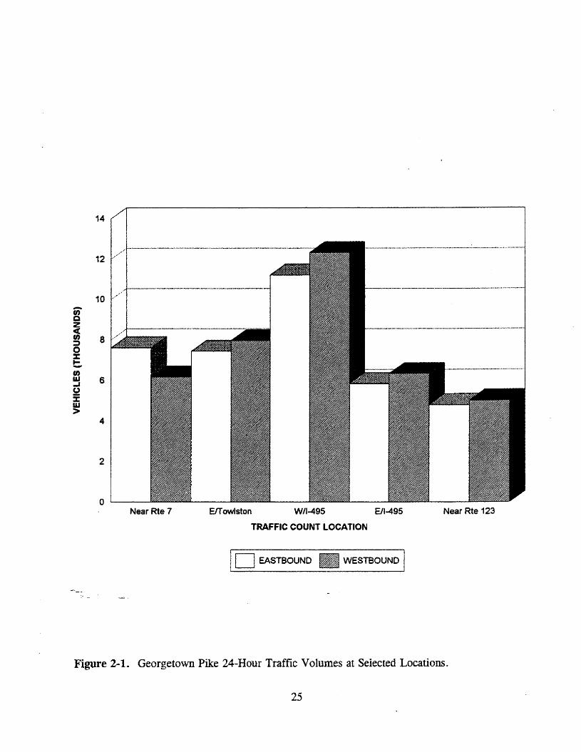
VDOT's Traffic Engineering Division, Special Studies Section, undertook specialtraffic counts as a part of this study and additional traffic counts were made by technicians atthe Virginia Transportation Research Council. These counts provide useful informationregarding travel trends on the Georgetown Pike, but are not intended to represent acomprehensive study of all traffic patterns on the road (see' Figures 2-1 and 2-2).
Special traffic counts were taken on the Georgetown Pike (Route 193) on threeThursdays: June 24, July 29, and August 12. These midnight-to-midnight counts were takenat different locations on different days, and direct comparisons of these one-day traffic countsare not necessarily valid. However, there is no reason to believe that these figures areatypical of summer Thursdays. Traffic counts at other times of the year could be higher orlower.
These special traffic counts were made along Route 193 at five locations: near Route7, east of Towlston Road, west of 1-495, east of 1-495, and near Route 123. Counts werealso taken on the ramps of the interchange at 1-495 and Route 193.
At the Route 7 (Dranesville) end, 24-hour traffic volumes on June 24 were 7,613eastbound and 6,169 westbound, for a total of 13,782 (no explanation is offered for this55/45 % directional distribution). Peak-hour morning traffic (eastbound) was 779 vehiclesbetween 6:30 and 7:30 a.m. Peak-hour evening traffic (westbound) was 565 vehiclesbetween 4:30 and 5:30 p.m.
The counters placed just east of Towlston Road (and east of the Great Falls NationalPark) on July 29 recorded 7,443 vehicles eastbound and 7,963 vehicles westbound, for a 24hour total of 15,406. Peak-hour morning traffic (eastbound) was 1,115 between 7:15 and8:15 a.m. Peak-hour evening traffic (westbound) was 1,049 between 5:15 and 6:15 p.m.
Comparing the Towlston Road data with those from Dranesville, one notes that thereis only a gradual increase in total traffic, from west to east, over the approximately six milesbetween these count locations. However, there is a significant increase in traffic volumesover the three miles between Towlston Road and 1-495, as will be seen.
Georgetown Pike traffic volumes are highest just west of the 1-495 interchange, where"two-way.traffic totaled 23,539 vehicles on July 29. As expected, eastbound and westbound
traffic was about evenly divided, with 52% westbound. Peak-hour morning traffic(eastbound) at this location was 1,567 vehicles between 7:30 and 8:30 a.m. Peak-hourevening traffic (westbound) was 1,681 vehicles between 5:30 and 6:30 p.m.
24
14
Near Rte 123ElTowlston WII-495 ElI-495
TRAFFIC COUNT LOCATION
Near Rte 7o
4
10 ..,/
2
.~ .__.._--_.~~.._..__._._-_...._-_._...._...._._----_._-
enQZc(In 8:::»o::z:...-In~ 6u%w>
ID EASTBOUND • WESTBOUND I
Figure 2-1. Georgetown Pike 24-Hour Traffic Volumes at Selected Locations.
25

2,000
1.500
(I)w....(J 1.000:fUJ>
500
Near Rte 7 ElTowlston W/I-495 ElI-495
TRAFFIC COUNT LOCATION
Near Rte 123
I0 EASTBOUND AM PEAK • WESTBOUND PM PEAK I
Figure 2-2. Georgetown Pike Peak-Hour Traffic Volumes at Selected Locations
26

The turning movement of eastbound Route 193 traffic at the 1-495 interchange is veryhigh. On July 29, eastbound Route 193 traffic totaled 11,218 vehicles (24 hours). Of thistotal, fully 7,376 vehicles (65.8%) turned left onto the ramp to 1-495 northbound. Peak-hourturning movements are very similar: of 1,567 vehicles eastbound, 997 vehicles (63.6%)turned left. This indicates that a significant portion of the eastbound traffic on Route 193 iseither crossing the Potomac River to reach destinations in Maryland or the District ofColumbia, or accessing other points in Northem Virginia via the George WashingtonMemorial Parkway.
Traffic from 1-495 southbound onto Route 193 is also high, as may be expected. OnAugust 12, 9,368 vehicles used that off-ramp, with a one-hour volume of 1,189 vehiclesbetween 5:00 and 6:00 p.m. On June 24, the total traffic volume was 11,414, with a peakhour volume of 1,722 between 5:15 and 6:15 p.m.
Just east of 1-495, traffic volumes are lower. On June 24, traffic was 5,856eastbound and 6,399 westbound, for a total of 12,255. Peak-hour morning traffic(eastbound) was 864 between 7:00 and 8:00 a.m. Peak-hour evening traffic (westbound) was979 between 4:45 and 5:45 p.m.
Near Route 123, traffic on June 24 was 4,820 eastbound and 5,020 westbound, for atotal of 9,840 vehicles. Peak-hour volumes were 1,058 eastbound and 1,044 westbound.
These counts give an idea of how crowded the Georgetown Pike is, especially duringthe morning and evening rush hours. The capacity of the Georgetown Pike currently is givenas 12,000 ADT (average daily traffic) by VDOT's Northern Virginia District TransportationPlanning Division. There was a volume of 23,539 vehicles on the busiest section of theGeorgetown Pike during the special counts. The road, for the most part, seems to beoperating over-capacity.
Geometric Design Standards
The safety of highways used by the public is the top concern of any transportationagency. There are many standards and guidelines that transportation agencies follow toensure that safety is always being considered. For example, the standards presented inAASHTO's A Policy on Geometric Design of Highways and Streets are considered to benational guidelines for standards for new highway construction. VDOT has adapted many ofAASHTO's standards into its own Road Design Manual, which includes the standards usedby VDOT when designing new highways or reconstruction projects.
Design standards are meant to be used as guidelines by designers when designing newhighways or reconstructing old highways to increase safety and capacity. However, there areoften times when exceptions to the standards are made for certain road projects. Whenexceptions are considered, safety plays a major role in the ultimate decision. Some
27

discretion is given to the design engineer. In Virginia, major variations from standards canbe granted only by VDOT's Chief Engineer.
Examples of standards (from VDOT's Road Design Manual) for roads classified asurban arterials -- as a portion of the Georgetown Pike is -- include a minimum lane width of11 feet and a minimum paved/stabilized shoulder width of eight feet. For a rural collector -which another segment of the Georgetown Pike is classified as -- the minimum lane width is12 feet, and for graded shoulders (cut and fill), the minimum width is eight feet. TheGeorgetown Pike does not meet the standard for the minimum width for shoulders alongalmost its entire length, and there are some sections that do not have lanes at least 11 feetwide.
Given these examples though, the only time an AASHTO or a VDOT design standardfor new highway construction would be applied to the Georgetown Pike would be on anyproject that involved more than maintenance -- i.e., bridge replacement, cross-sectionimprovements, the addition of shoulders, and other major construction projects.
Safety
Improvements to highways are almost always made for one of two reasons: toimprove the safety of the highway or to improve the capacity of the highway. Manyimprovements can increase safety and capacity at the same time. After reviewing the majorsafety improvements that can be made to two-lane highways, accident statistics and designfeatures on the Georgetown Pike are discussed.
Highway Improvements
Safety improvements that are often made to highways include increasing lane width,shoulder width, and clear zones; straightening horizontal curves; and cutting or fillingvertical curves to increase sight distance. Increasing lane width and shoulder width givesdrivers room to recover after their vehicles run off the road and also increases the distancebetween vehicles traveling in opposite directions on two-lane roads. Other important aspectsregarding shoulders include the provision of better emergency vehicle access, improved roadmaintenance performance, and a safe pull-off area for speed limit enforcement.
A clear zone, or a "forgiving roadside," is an area next to the roadway that has nofixed obstacles for vehicles to hit when they run off the road. Fixed obstacles include trees,guardrail, nonbreakaway signs or structures, sharp pavement-edge drop-offs, and deepdrainage ditches. These clear zones (or recovery areas) can range from simple eight-foot
___ shoulders to 30-foot-wide clear zones. The safety impact of clear zones is obvious -- with no"obstacleson the side of the road, an out-of-control vehicle or driver trying to avoid anaccident has a 'safe alternative to a collision.
28

The vertical alignment of roads can have a great effect on safety. The height of avertical curve can affect the sight distance of a driver. When a vehicle goes up a verticalcurve, the driver cannot see what is coming toward the vehicle on the other side of the roador what is happening on the downside of the hill. Reduction of vertical alignment canimprove sight distance, therefore permitting drivers to see the other side of the slope sooner,allowing for better accident avoidance.
The straightening of a horizontal curve can also improve sight distance. Anotherimportant safety factor on horizontal curves is the effect of entering and exiting a sharp curvefrom a straight portion of a highway. Excessive speed at these points can often cause avehicle to stray from its lane or to run off the road. The superelevation (or "banking") ofsuch a curve can improve the ability of a vehicle to stay on the road while also improvingpassenger comfort while the vehicle is passing through the curve.
A final major category of safety improvements involves intersections. When vehiclesenter a roadway from another roadway, factors such as sight distance and the grading of anintersection play important roles in the safety of that intersection. The number of turningmovements at an intersection affects safety. A vehicle leaving a road down slope from theentering road has the added difficulty of entering the roadway fast enough. If sight distanceis also restricted, the intersection can become very dangerous. Also, if the intersectioncannot be viewed from a decent distance, drivers might not be properly aware of theimpending intersection, which could cause accidents, especially rear-end collisions.
Accidents -- General Trends
. Between 1972 and 1992, there was a general decrease in the number of reportedaccidents on the Georgetown Pike. This prevalent trend can be seen in Figure C-l inAppendix C, which compares the total number of accidents for each year. The number ofaccidents ranged from 248 in 1972 to 155 in 1991; the average was 206 per year. Thegeneral decline may be a result of many factors. The likelihood that certain types ofaccidents are reported may change from year to year. A fatal accident must be reported, andbecause of unknown potential medical costs and the need for emergency care, an injuryaccident is also likely to be reported. However, there may be some fluctuation from year toyear in the number of accidents reported that involve only property damage. This could becaused by the dollar amount of property damage -- which must be reported -- increasing overtime. This increase is intended to account for inflation but may also cause fluctuation in thetotal number of accidents reported. Also, since the consequences of reporting accidents toinsurance companies have grown more severe over the 21-year time frame, the likelihood ofindividuals reporting accidents may have decreased, thereby creating further fluctuation.
The possible variance in reporting property damage accidents suggests that morereliable results may be found from an examination of trends in fatal and injury accidents. Acomparison between the injury and property damage only accidents is shown in Figure C-2 inAppendix C. This graph displays the general decline in the number of property damage only
29
accidents. The number of injury accidents, on the other hand, fluctuated over time, with nosignificant upward or downward trend.
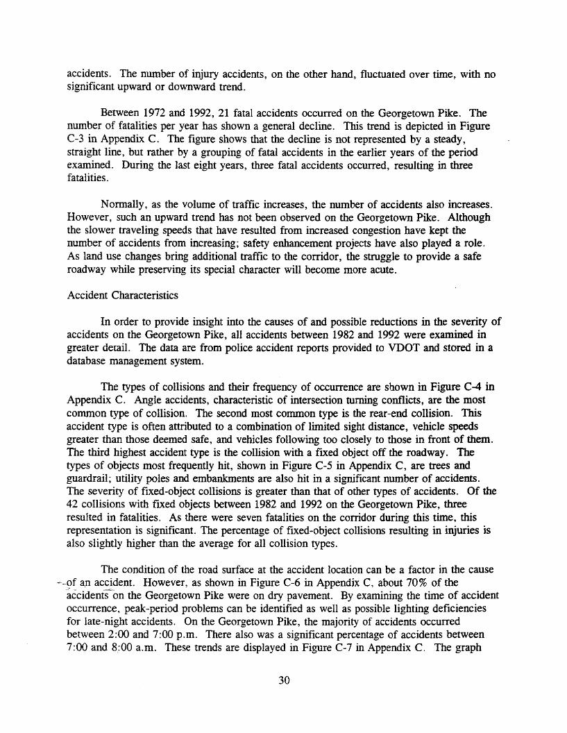
Between 1972 and 1992, 21 fatal accidents occurred on the Georgetown Pike. Thenumber of fatalities per year has shown a general decline. This trend is depicted in Figurec-3 in Appendix C. The figure shows that the decline is not represented by a steady,straight line, but rather by a grouping of fatal accidents in the earlier years of the periodexamined. During the last eight years, three fatal accidents occurred, resulting in threefatalities.
Nonnally, as the volume of traffic increases, the number of accidents also increases.However, such an upward trend has not been observed on the Georgetown Pike. Althoughthe slower traveling speeds that have resulted from increased congestion have kept thenumber of accidents from increasing; safety enhancement projects have also played a role.As land use changes bring additional traffic to the corridor, the struggle to provide a saferoadway while preserving its special character will become more acute.
Accident Characteristics
In order to provide insight into the causes of and possible reductions in the severity ofaccidents on the Georgetown Pike, all accidents between 1982 and 1992 were examined ingreater detail. The data are from police accident reports provided to VDOT and stored in adatabase management system.
The types of collisions and their frequency of occurrence are shown in Figure C-4 inAppendix C. Angle accidents, characteristic of intersection turning conflicts, are the mostcommon type of collision. The second most common type is the rear-end collision. Thisaccident type is often attributed to a combination of limited sight distance, vehicle speedsgreater than those deemed safe, and vehicles following too closely to those in front of them.The third highest accident type is the collision with a fixed object off the roadway. Thetypes of objects most frequently hit, shown in Figure C-5 in Appendix C, are trees andguardrail; utility poles and embankments are also hit in a significant number of accidents.The severity of fixed-object collisions is greater than that of other types of accidents. Of the42 collisions with fixed objects between 1982 and 1992 on the Georgetown Pike, threeresulted in fatalities. As there were seven fatalities on the corridor during this time, thisrepresentation is significant. The percentage of fixed-object collisions resulting in injuries isalso slightly higher than the average for all collision types.
The condition of the road surface at the accident location can be a factor in the cause--9f a.n accident. However, as shown in Figure C-6 in Appendix C, about 70% of the
accidents on the Georgetown Pike were on dry pavement. By examining the time of accidentoccurrence, peak-period problems can be identified as well as possible lighting deficienciesfor late-night accidents. On the Georgetown Pike, the majority of accidents occurredbetween 2:00 and 7:00 p.m. There also was a significant percentage of accidents between7:00 and 8:00 a.m. These trends are displayed in Figure C-7 in Appendix C. The graph
30
represents percentages of accidents and does not account for volumes of traffic. Hourlyvolumes are not available for the years examined, but concentration during peak trafficperiods is presumed.
Site-Specific Accident Analysis
Another benefit of looking at the trends of all accidents along the Georgetown Pike isthat smaller samples can be compared to the larger picture. A disproportionaterepresentation of a particular factor may mean that it plays a role in the accidents takingplace at that location.
As part of the accident analysis, those locations with the highest accident occurrenceand those representing a significant upward or downward trend were examined. Byidentifying these locations, some of the contributing factors were identified, and in somecases recommendations were made for safety improvement. All accidents between 1982 and1992 were included in the analysis. Because of the limited volume data available for specificlocations, accidents are presented in gross numbers only and not in accident rates. Wherepossible, consideration for volumes were made.
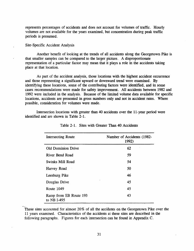
Intersection locations with greater than 40 accidents over the Ll-year period wereidentified and are shown in Table 2-1.
Table 2-1. Sites with Greater Than 40 Accidents
Intersecting Route
Old Dominion Drive
River Bend Road
Swinks Mill Road
Harvey Road
Leesburg Pike
Douglas Drive
Route 1049
Ramp from EB Route 193to NB 1-495
Number of Accidents (19821992)
62
59
54
50
46
45
45
43
These sites' accounted for almost 20 % of all the accidents on the Georgetown Pike over the11 years examined. Characteristics of the accidents at these sites are described in thefollowing paragraphs. Figures for each intersection can be found in Appendix C.
31

... Old Dominion Drive (Route 738): The highest number of accidents occurred at thisintersection. The total number of accidents by year is displayed in Figure C-8.Although there are a number of years that have an excessively high number, there isno upward or downward trend. A significant number of accidents occurred duringthe evening peak period, and the percentage of angle accidents was higher than thepercentage of angle accidents along the entire length of the roadway.
This intersection provides access to residential areas south of the corridor and is analternative route to the Tyson's Comer area and Arlington County. The north leg ofthis intersection provides access to Great Falls National Park. The high number ofangle incidents indicates conflicts between turning vehicles. As they were prevalentin the evening, they were probably occurring between westbound vehicles turning leftonto Old Dominion and eastbound Georgetown Pike traffic. The provision of a lefttum lane for this turning movement with an exclusive left-tum signal phase might helpreduce the accident problem. However, other steps to improve the sight distance foreastbound Georgetown Pike traffic might be warranted, as well as a review of thesignal timing and phasing to ensure adequate opportunity for the left-tum movementonto Old Dominion.
... River Bend Road (Route 603): A substantial number of accidents occurred at thisintersection. A slight upward trend can be seen in the number of accidents occurringper year, as is displayed in Figure C-9. This was likely due to increased commutertraffic at this location. This intersection provides access to several residential areasnorth of the Georgetown Pike and to Riverbend County Park. The percentage ofaccidents between 7:00 and 9:00 a.m. was greater than 55 %. This is very significant,as the total number of accidents during this time period on the entire corridor was lessthan 13%. Several citizens provided comments regarding this problem. During themorning peak period, drivers wait on River Bend Road to tum left onto theGeorgetown Pike. Occasionally, an eastbound driver will stop long enough to allow acar to make the tum. Motorists behind the courteous Georgetown Pike driver willuse the right-tum lane into Nethercliffe Hall Road to pass the stopped vehicle. Thedriver turning from River Bend Road cannot see this motorist until a collision is closeat hand. This explanation is supported by the abnormally high representation of angleaccidents at this site.
It was suggested that the right-turn lane be closed to prevent this conflict. Althoughthis may be the only complete solution, eliminating this lane may have other safetyand capacity consequences that cannot be fully known until implemented. It isrecommended that other possible improvements be attempted before going to thisextreme. One such alternative might involve a positive barrier to make use of theright-turn lane as a passing lane very difficult while still allowing complete access.This suggestion is depicted in Figure C-10.
... Swinks Mill Road (Route 684): Rear-end collisions represented over 46% of theacc-idents at this location, as compared to 29% of the accidents on the entire road.
32
Figure C-11 shows a general decline in the number of accidents each year. The timethe accidents occurred corresponded very closely with that of all :"' ccidents on theroad. Steps should be taken to increase the sight distance so that turning vehicles arevisible sooner and to increase driver expectancy of stopped or slowed vehicles. Thissite might also benefit from turning lanes to provide storage for waiting vehicles.
~ Harvey Road (Route 1970): Although this intersection represents a high-accidentlocation, there was a general decline in the number of collisions over the past sixyears. This trend can be seen in Figure C-12. The accident occurrence was highestin the afternoon from 2:00 to 6:00 p.m., and there was a high representation of angleaccidents. A traffic signal at this location provides access to the north and south forresidential areas. This afternoon peak of accidents may be due to the increasedvolume of traffic during those hours from Langley High School drivers. The phasingand timing of the traffic signals should be reviewed to ensure adequate access for allmovements.
II- Leesburg Pike (Route 7): The number of accidents at this intersection fluctuatedover recent years and significantly increased in 1992 to nine accidents. These trendsare depicted in Figure C-13. A high percentage of these accidents occurred in theafternoon, between 1:00 and 5:00 p.m. Seven of the nine accidents in 1992 occurredduring this time frame. All the accidents in 1992 and more than 90 % of those in theprior years were rear-end collisions. This is significantly higher than the 29 % figurefor all rear-end collisions that occurred on the Georgetown Pike. The possibility ofincreasing driver expectancy of stopped vehicles should be examined at thisintersection.
., Douglas Drive (Route 937): Except for a peak of 11 accidents in 1990, the numberof accidents at this intersection did not change significantly over the time periodexamined, as is depicted in Figure C-14. There was a sharp increase in the numberof collisions in the morning peak hours and in the early afternoon. The majority ofaccidents were angle collisions. The high number of accidents in the morningindicates a problem involving drivers turning out of the subdivision.
.,' Mackall Avenue (Route 1049): This intersection warrants attention because of thehigh number of accidents, but also because of the steady decrease in accidents overthe 11 years examined. This trend is shown in Figure C-15. Eleven accidentsoccurred at this location in both 1982 and 1983. Over the next four years, thenumber of accidents per year ranged between three and five. In January of 1987, aroad project was initiated to change the grade and improve the vertical sight distance.The project was completed in October of that year, and only six accidents haveoccurred in the six years since then, with no more than two accidents occurring inanyone year.
., Ramp from Route 193 Eastbound to 1...495 Northbound: The number of accidentsat this ramp in 1989 was the greatest over the l l-year period, but accidents have
33
steadily declined since. This trend can be seen in Figure C-16. The times theaccidents occurred were at the same peak periods as for the total sample. Onenotable factor is that a much greater percentage of the accidents at this location wereangle collisions. Only about 32% of all accidents on the entire corridor were anglecollisions, but at this ramp, 86% were categorized as angle collisions. This is notsurprising, as a significant percentage of the eastbound drivers on this section of theGeorgetown Pike make a left turn onto this ramp. Over the last several years,suggestions and complaints regarding this intersection have been received fromcommuters. Changes in traffic control measures have been implemented as warrantedto help alleviate the problem.
Two additional locations were examined that had fewer than 40 accidents. The firstof these locations, 0.5 mile east of Old Dominion Drive, was the site of 38 accidents. It isof significant interest because it was the only location with such a high occurrence ofaccidents that was not an intersection. This location falls within the 1.24-mile section of theGeorgetown Pike between Old Dominion Drive and Towlston Road, is adjacent to GreatFalls National Park, and is distinguished by its meandering nature. This short stretch ofroadway accounted for 10.73 % of all accidents along the Pike between 1982 and 1992; itaccounted for 18.8% of all accidents at nonintersection locations -- about double thepercentage expected from the percentage of roadway represented. These accidents werespread more evenly throughout the day, with some concentration between 8:00 and 11:00p.m. About 50% of the accidents occurred when the pavement was wet, which issignificantly higher than the overall rate of 24%. Almost 70% of these accidents werecollisions with fixed objects off the roadway, and the objects most frequently hit were treesand guardrail. Although some of these accidents were attributed to driver inattention andvehicle speed, the weather and time of day also appear to have played roles. Additionalwarning and possible lighting may be needed on this stretch of roadway as it has a moresevere curvature than other sections. By improving driver expectancy, proper precautionscan be taken. This section of the roadway should also be reviewed and suggestions made onhow to increase the clear zone adjacent to the roadway to allow an errant vehicle to re-enterthe roadway without hitting a fixed object.
The second location, Springvale Road, was examined not because of the high numberof accidents, but because of the strong decline in accidents over the l l-year period. Asdepicted in Figure C-17, the number of accidents at this intersection peaked in 1984 and1985, with eight each year. The sight distance at this intersection was very poor, with angleaccidents representing the majority of collisions. One of the accidents in 1984 resulted in afatality, as did an accident in 1980. A road project to change the grade and increase thesight distance at this location was completed in November of 1989. In the three years since
--$~ projectwas completed, only three accidents have-occurred.
In summary, except for the one meandering section of the Georgetown Pike, all highaccident locations were at intersections. These accidents typically occurred during one orboth peak traffic periods. The types of collisions most dominant were angle and rear-endconflicts. Critical to these safety concerns are adequate sight distance, appropriate
34

deceleration and storage areas, and driver expectancy. In two locations described previously,measures taken to change the alignment and increase the sight distance appear to have beeneffective in reducing the number of accidents at these locations. Additional scrutiny of highaccident locations should occur so that carefully planned, effective changes can beimplemented. Also, increased knowledge of these accident locations would allow properprecautions to be taken during the planning and development stages and therefore might helpprevent the creation of additional high-risk locations.
Road Design -- General Considerations
When designing a highway project, the idea of roadway consistency should be kept inmind. Drivers expect certain things on roadways -- anything that could be a surprise todrivers should be warned of well in advance. A consistent design of roadways, especiallywhen spot improvements are made, will aid driver expectation.
Safety is of the utmost concern to highway officials, and it is the one area that isnever compromised. However, considering the fact that each road in the state is differentand involves many different factors, there are options available to providing safe means oftransportation. One fact to keep in mind is the following:
Most of the present day roadway routes were in existence by [1920], but theywere largely unpaved, unsuited to all weather travel by automobiles, andgenerally not intended for use by motor vehicles. . . . the automobileinherited, and had to make do with, a road system created for another meansof transportation. 12
Making these road systems safe for automobile drivers is not an easy or inexpensive task, butit is necessary. Roads were originally built for use by horse and wagon, whose speed waswell below five miles per hour, a speed at which sight distance on curves is not a greatconcern. The Georgetown Pike retains a great deal of its pre-motor vehicle alignment.
Given all of the information on the importance of safety, and the necessity of somesafety, improvements given accident statistics for the Georgetown Pike, the study team feltthat a recommendation for improving the overall safety of the Georgetown Pike would beappropriate. There seems to be a consensus among interested parties that the traveled way ofthe Georgetown Pike should remain in its present location and should not be widened.However, traffic volumes continue to grow and accidents continue to occur.
Shoulders
Since the Georgetown Pike has almost no shoulders in several areas, and minimalshoulders in other areas, this is an obvious area to examine. It is well known that pavedshoulders can improve safety. However, paved shoulders would be objectionable to manypeople who want to maintain the minimum asphalt intrusion on the land. For this reason, thestudy team examined whether unpaved shoulders would improve safety.
35

A method exists for predicting the accident rate of various two-lane, two-way, pavedrural roads on state primary and secondary systems. This method, developed by Zegeer, etal, is summarized in the Transportation Research Board's report entitled Designing SaferRoads." The Zegeer method is intended for use with rural roads and thus does not predictintersection accidents. However, for some stretches of the Georgetown Pike, there are fewstreet entrances and rural conditions prevail. Fortunately, intersection and non-intersectionaccident data can be separated, and reasonable comparisons can be made between actualaccident data and predictions made using the Zegeer method.
For this method, the accident rate is defined as the number of run-off-road, head on,opposite-direction side-swipe, and same-direction side-swipe accidents per mile per year.Significantly, intersection and rear-end accidents are not predicted by the Zegeer method.The roadside hazard rating used in this methodology is a median rating of the roadsidehazards (fixed-objects such as trees that are close to the road) for a particular highwaysegment that is measured subjectively on a scale from one (least hazardous) to seven (mosthazardous) .
For analysis of the Georgetown Pike, the following assumptions were made, for thetwo-lane sections only:
Traffic Volume:Pavement Lane Width:Shoulder, Paved:Shoulder, Unpaved:Terrain:Roadside Hazard Rating:
17,000 ADT (median value)10.15 feet (weighted average)ofeet0, 1, 2, 3, 4, 5, and 6 feetRolling5 (of a possible 7)
The results of the analysis predicted that the present road, with no significantshoulders over much of its length, should experience 7.97 accidents per mile per year,excluding rear-end collisions. This predicted figure agrees surprisingly well with the 1,169nonintersection accidents that occurred over the entire length of the Georgetown Pike from1982 through 1992. This is an average of 9.01 accidents per mile per year, including rearend collisions.
Having developed confidence that the Zegeer method was appropriate, it was thenused to predict the effects of adding grass-covered shoulders while holding lane width andother variables constant. The results, shown graphically in Figure C-18 in Appendix C,predicted that adding six feet of unpaved shoulder (consisting of gravel, turf, or earth) couldreduce the nonintersection accident rate by 35%, to 5.2 accidents per mile per year.
Alternatives to the Use of the Georgetown Pike
There are a number of routes that can and do serve as alternatives to the GeorgetownPike. A list of these routes and the improvements planned or being considered for them
36

follows (sources include the Northern Virginia 20-year subregional plan, the Fairfax CountyComprehensive Plan Transportation Map, and news articles):
110 Route 7 (Leesburg Pike): widening to six lanes, limited access, from the Dulles TollRoad to the Loudoun County line; to a six-lane arterial from the Loudoun County lineto Route 28; to six lanes, limited access, from Route 28 to Leesburg;
.. Dulles Toll Road: new construction of a four-lane, privately built extension fromRoute 28 to Leesburg; adding an HOV (high-occupancy vehicle) lane in each directionover the entire length;
110 Fairfax County Parkway: new construction of a four-lane arterial from BaronCameron Avenue north to Route 7, and new construction of a six-lane arterial fromthe Dulles Toll Road to Baron Cameron Avenue;
.. Old Dominion Drive: no major improvements planned;
110 1-495 (Capital Beltway): adding a fifth lane in each direction, most likely an HOVlane; and
.. Route 123; widening to six lanes from Tyson's Comer to the George WashingtonMemorial Parkway.
None of these improvements is scheduled for completion in the next few years. Theimprovements that could have the greatest affect on the Georgetown Pike are the Route 7widening, the Dulles Toll Road extension, and construction of the Fairfax Parkway betweenRoute 7 and the Dulles Toll Road. However, it does not appear that significant amounts oftraffic will be diverted from the Georgetown Pike even when these projects are completed.
Other alternative corridors or means of transportation include carpooling and itsrelated ridesharing/commuter parking lots; public transportation, including possible masstransit rail lines in the Dulles Toll Road median; a western bypass of Washington, D.C.; andbicycle or pedestrian circulation on existing and planned trails, including those that areincluded on the Fairfax County Trail Map.
Another alternative to more cars on the Georgetown Pike is the broadened use oftelecommuting. Businesses can implement programs that allow their employees to work athome with computers, facsimile machines, and telephones. Telecommuting could take placefull time or part time. The main benefit of this program would be to relieve commuter
- __ traffic using area roads. In addition, reducing traffic through telecommuting could reduce air"0 pollution, which is one requirement of the Clean Air Act Amendments of 1990 and animportant factor in the environmental programs of ISTEA.
37

Funding Sources for Alternatives
The funding process for highway maintenance and improvements is very complicatedand is beyond the scope of this study. However, a description of funding sources that couldbe used on improvements to alternative transportation corridors will provide a picture of theoptions open to VDOT for funding a transportation project.
In terms of funding, it is important to remember that there are many projects thatneed to be constructed with a limited amount of funds. Therefore, the allocation of money toimprove these corridors (or for use on the Georgetown Pike itself) would not be automatic -the usual process of allocating funds at the state, regional, and local levels would still need tobe followed. Allocations for improvement projects are listed in the CommonwealthTransportation Board's Six-Year Plan, the most recent of which allocated funds throughFiscal Year 1998-1999. The Six-Year Plan contains no allocations for improvements on theGeorgetown Pike. There are sources of funds for safety improvements and regularmaintenance that could be applied to the Georgetown Pike if it was decided that such workwas necessary.
There are three major sources of funding for transportation projects: federal, state,and local funds. (All federal funds flow to VDOT with some restrictions on their use.) Afourth source, private funds, is being used for the Dulles Toll Road extension to Leesburg.After a description of federal and state sources, a list of possible funding sources forimprovement to four of the Georgetown Pike's alternative corridors is presented.
Federal Sources
The most recent federal transportation funding bill is the ISTEA, in which manydifferent funding programs are outlined. For the purposes of this study, those fundingprograms that could be applied to the Georgetown Pike and/or its alternative transportationcorridors are presented.
National Highway System
The National Highway System (NHS) includes interstate highways and otherprincipal, connecting arterial roads within states that are designated as part of the NHS.NHS funding can be used for a variety of projects -- from new construction to .maintenance.These funds must be met with a minimum state match of 20% of the total project cost, as doall ISTEA-allocated funds. (The Georgetown Pike will not be included in the NHS.)
- __ Surface Transportation Program
The Surface Transportation Program (STP) includes funding that goes to states forallocation to transportation projects. Enacted as a major part of ISTEA, the STP has fundsfor a variety of transportation projects.
38

The STP provides broad discretion for State and local governments to fund awide variety of activities, including highway and transit capital projects,carpool projects, bicycle and pedestrian facilities, planning, and research anddevelopment. 14
Within the STP, there are specific required funding categories. Fully 10% of STP fundsallocated to a state must be used for transportation enhancements. Another 10% must beused for safety improvements.
Funds from the STP can also be used for planning, including plans for reaching airquality standards in areas that do not meet the standards set in the Clean Air ActAmendments of 1990. The allocation of a portion of STP funds to specific projects areprioritized regionally by the Metropolitan Planning Organizations (MPOs). The MPQs takeinto account the entire regional transportation system and its intennodal nature whenprioritizing these funds.
Congestion Mitigation and Air Quality Improvement Program
The Congestion Mitigation and Air Quality Improvement program (CMAQ) is anothermajor new program under ISTEA. Funding for CMAQ projects (which are identified byMPOs) is used to alleviate congestion problems, and most important, to aid in helpingnonattainment areas meet air quality standards. This program has $6 billion authorized oversix years to be allocated to help with these problems. Since Northern Virginia is anonattainment area, some of these funds might be used there.
Other Environmental Provisions
ISTEA also has provided limited funding for the Interim Scenic Byways Program andfor the National Scenic Byways Program, which is being developed by a Scenic BywaysAdvisory Committee. These funds are to be used for technical assistance and grants to statesthat have existing byways programs or to states wanting to set up byways programs that meetnational standards. Those standards have yet to be established by the Advisory Conunittee.
State Sources
The federal funds provided under ISTEA are allocated to states for uses specifiedunder each program. Within these program allocations, states have broad discretion in howto spend the funds.
___Highway Maintenance and Operating Fund
In Virginia, federal funds go first into the Highway Maintenance and Operating Fund(HMOF). SOIDe revenues from state motor fuel taxes also are placed in the HMOF. Thecombined funds are used first for highway maintenance and operating costs (the only federalfunds for maintenance are for interstates) as well as for other costs, such as transfers to other
39
agencies. Any remaining funds are transferred into the state's Transportation Trust Fund(TTF). Designated federal funds are passed through the HMOF to the TTF.
Transportation Trust Fund
The Transportation Trust Fund was established in 1986 as the result ofrecommendations of the Commission on Transportation in the Twenty-FirstCentury (COT-21). A major reason for its creation was to establish amechanism for funding multimodal transportation facility construction. 15
TTF revenues are provided by pass-through funds from the HMOF, revenues from1/2 % of the state sales tax, state motor fuel taxes, and other taxes. TTF funding is used tosupport aviation, ports, public transportation, and highways.
Federal and state highway funds are combined and allocated together, throughallocation processes controlled by the Virginia legislature. Highways that serve asalternatives to the Georgetown Pike will be constructed or improved using TTF funds.
Enhancement Funding
The requirement in ISTEA that 10% of STP funds must be used to fund transportationenhancements provides a source of funding for scenic byways and historic roads. There areten categories of projects for which these enhancement funds can be used:
1. Provision of facilities for bicycles and pedestrians.2. Acquisition of scenic easements and scenic or historic sites.3. Scenic or historic highway programs.4. Landscaping and other scenic beautification.5 . Historic preservation.6. Rehabilitation and operation of historic transportation buildings, structures or
facilities.7. Preservation of abandoned railway corridors.8. Control and removal of outdoor advertising.9. Archaeological planning and research.
10. Mitigation of pollution due to highway run-off. 16
Most states have created a Transportation Enhancement Program to allocate funds to projectsunder various categories.
The enhancement programs developed by Maryland, Delaware, Pennsylvania, and--;Virginia.are essentially similar. All of the programs were created following basic FHW A
guidelines, and the ten enhancement categories are the same for all the programs. Areas thatdiffer somewhat from state to state include the makeup of project selection committees, theresponsibility for final approval, the matching funds policies, and the number of fundingcycles completed. This information was compiled from state DOT enhancement program
40

documents and the Rails-to-Trails Conservancy's report entitled, Enhancing America'sCommunities: A Nationwide Survey of The Transportation Enhancements Provisions ofISTEA. 17
~ Delaware: Delaware's Transportation Enhancement Program had not yet completed afull funding cycle as of December 1992. The projects are reviewed on an ongoingbasis, with planning and funding selections made annually. The final projectrecommendations are made by an executive-level Advisory Committee, whichincludes one citizen. The fmal selection of projects to receive enhancement funding ismade by the Secretary of Transportation. Federal funds must be matched at 20 % ofthe total project cost. The local sponsors propose the level of local match for theirproject.
~ Maryland: Maryland's and Delaware's enhancement programs are nearly identical.Maryland also accepts applications on an ongoing basis, and selection is accomplishedon an annual basis. The final recommendations are made by an interagencyexecutive-level Advisory Committee, which does not include any citizens. The fmalselection and approval reside with the Secretary of Transportation. Maryland hascompleted two funding cycles, allocating a total of $12,457,000 combinedfederal/state/local match. The matching fund policy in Maryland is different fromothers in that the project sponsor must provide 50% of the total project cost, to becombined with federal (40%) and state (10%) shares.
~ Pennsylvania: The Pennsylvania Transportation Enhancement Program hascompleted two funding cycles, allocating a total of $20,130,000 in federal, state, andlocal funds for enhancement projects. The fmal recommendations are provided by anAdvisory Committee of state and local officials and representatives of public interestgroups. Final selections are made by the State Transportation Commission. Projectsponsors must provide at least 20 % of the proposed project costs.
~ Virginia: Virginia's Transportation Enhancement Program is relatively new, with thefirst application deadline on August 1, 1993, and the first of the annual selections
, scheduled for November 1993. Virginia's program is very similar to Pennsylvania'sin that recommendations are made by an Advisory Committee with final approval andselection made by the Commonwealth Transportation Board. Virginia's program alsorequires project sponsors to provide at least 20% of the total project costs.
This comparison of enhancement programs identified important information regardingfunding. Both Pennsylvania and Virginia provide the option for in-kind contributions of
--!and, materials, and/or labor to make up part of the...20% match. However, under FHWA.advisement on in-kind contributions, the amount of the contributions can be applied only toreduce the total project cost (with the exception of certain right-of-way donations); theycannot be used to make up a portion of the required 20 % match of federal funds .18 Thisprovision will most likely be changed in the near future in both programs.
41
The major element in these enhancement programs seems to be the provision ofmatching funds from sources other than state-allocated transportation funds. In Virginia, inparticular, it seems that those projects with the 20 % minimum funding provided from sourcesother than state transportation funds and in-kind contributions will have the greatest chancefor success.
Application of Sources
VDOT's Programming and Scheduling Division provided a list of possible sources offunding for improvements to the following alternative transportation corridors:
... Route 7 (Leesburg Pike): Eligible funding could include NHS funds, state-onlyfunds, regular primary allocations allocated to Northern Virginia, regional STP fundsavailable for prioritization by the responsible MPO (the National Capital RegionTransportation Planning Board), and Commonwealth Transportation Boarddiscretionary statewide STP funding .
... 1-495 (Capital Beltway): Eligible funding includes NHS funds .
... Fairfax County Parkway: Funding has been a combination of developer financing,county board financing, secondary road funds, and NBS funds; eligible fundingincludes statewide STP funds.
... Dulles Toll Road: Currently funded through toll collections, funding of the privateroad could be through a combination of loans and private investment.
Although many of these improvements have yet to be approved or funding allocated forthem, this list does demonstrate the number of options available to VDCT, Fairfax County,the local MPO, and private investors to pay for highway construction.
Permits
VDOT has another major role in the administration of the Georgetown Pike, and thatis the issuance of pennits to private owners and developers. Developers and otherlandowners are required to obtain permits issued by VDOT before anything may be placed inits right-of-way or connections made to a state road. These pennits include right-of-waypermits, which regulate such things as utilities, fences, gates, mail boxes, and the like.Another type of permit is an entrance permit, or a permit that allows owners or developers to
_ build entrances to their land from the state-owned road.
42

SECTION 2.2 -- THE ROLE OF FAIRFAX COUNTY
Fairfax County also plays a role in providing transportation within the county.Beyond working with VDOT in the allocation of funds for road improvement projects, thecounty also has a number of policies regarding transportation. This includes the review ofsite plans for new developments to ensure that they meet county policies. The county alsosupplies its own funding for a number of transportation projects that otherwise might not beconstructed in a timely fashion.
Potential Transportation Impacts of New Development
The impacts of actual development and potential road projects on the character of theGeorgetown Pike were a recurring issue throughout this study. Many comments made at theGeorgetown Pike Public Hearing in August focused on the fear that any changes to the roadwould have a detrimental impact on the aesthetic nature of the corridor. Residents statedtheir affection for the overhanging trees and the meandering alignment that create' a ruralatmosphere. Any changes in these features, they contended, would detract from the beautyof the corridor.
While it is true that the trees, hills, and curves do add to the character of the road,scenic and environmental concerns are not the only objectives VDOT must consider inestablishing and administering its policies. VDOT's mission statement is to provide safe,efficient, effective, and environmentally sound highways and surface transportation systemsnow and into the twenty-first century. 19 Balance, an integral aspect of this mission, is oftendifficult to achieve, and compromises are often required.
As there are no plans at this time or within the 20-year planning horizon toreconstruct the Georgetown Pike, any changes that occur will be the result of newdevelopments or spot safety projects. The focus of this section is on the changes that willresult because of new development. All growth generates additional traffic; however, ofmost interest along the Georgetown Pike are new access points. A new entrance createsadditional points of conflict and can reduce the capacity of the roadway by slowing downthrough traffic while turning movements are made. The impact of entrances is emphasizedin VDOT's Site Review Manual:
Each entrance onto the road will decrease the road's capacity, the ability toconvey traffic. Each entrance will also adversely affect the safety of themotorists. The second most predominant factor (next to the average dailytraffic) in the overall accident rate of highways is the number of entrances perniile. 20
Access management and good entrance design can minimize the impacts of these newentrances, and both VDOT and Fairfax County playa role in achieving these goals on theGeorgetown Pike.
43

Nature of the Problem
VDOT's Northern Virginia District has been criticized over the past decade by thosewho feel that a lack of planning has resulted in an inadequate transportation network. Manyhave questioned why current traffic congestion was not anticipated and prevented. One ofthe explanations for the congestion is that vehicle usage in Northern Virginia is multiplyingtwice as fast as the population. Between 1980 and 1990, the population increasedapproximately 32% while the number of vehicle miles traveled increased 68%.21
Despite any possible explanations, disgruntled travelers frequently verbalize theircriticisms to VDOT representatives. Critics and transportation officials alike have pointed tothe fast rate of development as one of the causes of congestion and have expressed thephilosophy that development should not be allowed unless the transportation network isavailable to accommodate the increased traffic generated. Although VDOT does not haveany control over the amount or rate of development, as that is a local issue, it does havesome control over the improvements required to mitigate the impacts of new developments.This is one area where the state can' directly work to match road improvements with theanticipated growth. Developers' contributions are one of the few, consistent sources ofprivate funding for transportation improvements. It is not expected that developers solve allthe traffic woes of the county but rather improve facilities sufficiently so that thedevelopments will not exacerbate the problem.
VDOT's Responsibility in the Site Plan Review Process
VDOT has the authority to regulate entrances to state highways as cited in the Codeof Virginia, Section 33.1-198. The construction of such entrances must be in accordancewith various VDOT standards. However, each case is reviewed individually. Measuresbeyond the minimum standards are often required to ensure the safe and efficient use of thehighway. Under Section 33.1-12 of the Code of Virginia, VDOT is given the authority andresponsibility to protect traffic, and it is under these broad general powers that VDOT canlegally make requirements exceeding the minimums. 22
In VDOT's Northern Virginia District, where the number and magnitude of newdevelopments are so large, there is a section charged with reviewing all site plan submissionsand providing recommendations for road improvements. This Land Development Sectionensures that any roadways in a site plan intended to be taken into the state system meetVDOT's Subdivision Street Requirements and that all entrances to state-maintained roadwaysmeet VDOT's Minimum Standards of Entrances to State Highways. VDOT engineers alsotry to ensure that sufficient accommodations are made so as to minimize the impact on the
- __ road network. VDOT's Fairfax Residency -- the body ultimately responsible for maintaining"'state roaas within Fairfax County -- plays a role in reviewing and approving site plans.Access to a state road is prohibited without an entrance permit, which is issued by theresidency.
44
Fairfax County's Responsibility in the Site Plan Review Process
The county is responsible for the physical development of territory within itsjurisdiction. Under the Code of Virginia, the state mandates local commissions to prepareand recommend a comprehensive plan for this development. The purpose of thiscomprehensive plan is to
achieve a coordinated, adjusted, and harmonious development of the territorywhich will, in accordance with present and probable future needs andresources best promote the health, safety, morals, order, convenience,prosperity and general welfare of the inhabitants."
One basic thrust of the county's comprehensive plan is to balance land use with publicfacilities, such as the transportation infrastructure. There are three divisions within thecounty government that are primarily involved with development and its impact ontransportation. The Office of Comprehensive Planning determines the existing zoning for thecounty and develops the county's blueprint for the future. The Department of EnvironmentalManagement is responsible for reviewing site plans and enforcing zoning regulations. TheOffice of Transportation coordinates the county's interest in development with other plannedtransportation improvements.
Site. Review Process for Residential Subdivisions
As there is a strong relationship between the capacity and design of a highway facilityand the zoning designation of adjacent property, there must be close coordination andcooperation between the two jurisdictions that govern these areas -- VDOT and FairfaxCounty. 24
In order to build a new subdivision, a plan must first be produced by the landowneror land developers and then submitted for county approval. The county makes sure that theplan is in accordance with its zoning ordinance, the instrument by which the specific land use.recommendations of its comprehensive plan are implemented." Subdivision regulationsmust be adhered to if the parcel is being divided into lots smaller than five acres. Thedesign of all facilities constructed to serve the new development are governed by the county'sPublic Facilities Manual:"
As part of the county's review process, development plans are submitted to VDOT sothat it may assess the impact to the roadway. In the Northern Virginia District, where a highpercentage of the roads operate above the traffic volume for which they were designed,
«<:ynoT engineers typically ask for substantial mitigation measures. This request usuallyincludesfight-tum and left-tum lanes into a new development and dedication of right-of-wayto provide sufficient width for the ultimate roadway planned in the county's comprehensiveplan. It may also include alleviation of off-site impacts of the development, such ascontribution to a traffic signal at a nearby intersection. Frequently, a process follows wherethe developer or landowner tries to convince VDOT that the impacts of its development do
45

not warrant such extensive improvements. VDOT must consider any additional informationprovided by the developer, or extenuating circumstances, and determine which improvementsare truly reasonable. Although VDOT engineers are directed to work with the developer asmuch as possible, their first responsibility is to ensure the safety of the traveling public."
Neither the county nor the developer is required to incorporate VDOT'srecommendations into the plan at this point. The plan can proceed to the next step withoutVDOT approval. However, even with the county's approval, the developer cannot beginentrance work without an entrance permit. The Fairfax Residency, the body responsible forissuing these permits, reviews the plans and notes if the recommendations made by the LandDevelopment Section have been incorporated. The residency has the option of requiringrevisions to the plan or approving it as is. If the residency requires changes not deemedreasonable by the developer, the developer may request a review by VDOT's districtadministrator. If the district administrator does not approve the waiver, the developer mayappeal to VDOT's Chief Engineer.
Benefits of Managing Access
The benefits of access management can best be seen where it has been most ignored:on commercial strip developments. Delays and accidents are numerous along thesecorridors; they are also unsightly for motorists. Although access problems are magnified incommercial areas, the issues are the same for residential areas. In order to preserve thecapacity and safety of a highway, it is vital to limit the total number of access points, to havesufficient separation between access points, and to provide appropriate design of entrancesfor the type and volume of expected traffic on both the existing road and the new one. Bymanaging access, more costly, time-consuming, and socially disruptive future roadwayreconstruction can often be avoided. 28
The dilemma of implementing access management programs was summed upconcisely in an FHWA report entitled Access Management for Streets and Highways, whichstated that the application of these techniques is often a controversial issue among theindividuals and agencies affected." Property owners generally feel entitled to certainproperty rights of adjoining road facilities. Highway officials, charged with maintaining thesafety and capacity of the roadway system, are often accused of being insensitive to the needsof property owners and the community. A balanced, comprehensive program that providesreasonable access while maintaining safety and efficiency in traffic movement is essential. 30
Auxiliary lanes are an important component of access management on arterials such--- asthe Georgetown Pike. The purpose of separate.turning lanes is to expedite the movement
.7" of through traffic, increase intersection capacity, permit the controlled movement of turningtraffic, and promote the safety of all traffic. 31 When undue deceleration or acceleration byaccessing traffic takes place directly on the highway, it disrupts the flow of through trafficand often is hazardous. 32 The decelerating vehicles cause a speed differential between themand the through traffic. This differential is a major factor in the frequency and severity of
46

conflicts. 33 This problem is exacerbated by poor sight distance. If a driver does not see aslow-moving vehicle ahead, the chance for a conflict is higher.
The left-turning vehicle is the most susceptible to accidents and operational difficultiesat an intersection or entrance." Where left-turning vehicles share a lane with throughtraffic, the left-tum movement can be responsible for considerable delay and trafficdisturbance, especially when the volume of opposing traffic is high." Accidents involvingleft-tum movements are typically more severe than right-tum movement or throughmovement accidents, with injury accidents being much more common.36
In terms of safety, special treatment for right-turning traffic is less critical than forleft-turning traffic." However, exclusive right-tum lanes can be cost-effective in certainsituations as they reduce conflicts with following vehicles, side-swipe conflicts with throughvehicles, and conflicts with pedestrians crossing a street being entered by right-turningvehicles. 38 By removing slow-moving vehicles from the traffic flow, right-tum lanes alsohelp maintain the capacity of the mainline.
WalTants for Auxiliary Lanes
The decision to install auxiliary lanes should be determined by a traffic engineeringstudy, with various guidelines and warrants used to direct the decision. 39 As stated inAASHTO's A Policy on Geometric Design of Highways and Streets:
Many factors must be considered [in warranting acceleration and decelerationlanes], such as speeds, traffic volumes, capacity, type of highway, serviceprovided, the arrangement and frequency of intersections, and accidentexperience."
Several general conclusions are listed by AASHTO, and those that are germane to this studyare as follows:
1. Speed-change lanes are warranted on high-speed and on high-volume highwayswhere a change in speed is necessary for vehicles entering or leaving thethrough-traffic lanes.
2. All drivers do not use speed-change lanes in the same manner; some use littleof the available facility. As a whole, however, these lanes are usedsufficiently to improve the overall safety and operation of the highway.
3. Use of speed-change lanes varies with volume, with the majority of driversusing them at high volumes.
4. Deceleration lanes on the approaches to at-grade intersections that "alsofunction as storage lanes for turning traffic are particularly advantageous, and
47
experience with them generally has been favorable. Such lanes reduce hazardand increase capacity.41
The AASHTO guidelines go on to state that deceleration lanes are particularly advantageouson high-speed roads because if not provided, turning vehicles must slow in the travel lanes.If drivers of following vehicles are not alert, rear-end collisions are a likely result. 42
FHWA's Access Management for Streets and Highways mentions that many states andmunicipalities have adopted warrants for when to provide right-turn and left-tum lanes thatserve as guidelines for their engineers and the developers. These guidelines vary widely, andwithin a jurisdiction where a written policy exists, authorities indicate that there is often littleconsistency in the way they are actually administered. 43
Requirements for Left-Tum Lanes
Criteria have been developed for providing separate left-tum lanes by several studies.One study requires consideration of the peak-hour volume of the intersection approach and ofleft-turning vehicles and the operating speed. The AASHTO warrants for left lanes includethese same factors, but they also consider the opposing volume of traffic. 44 TheseAASHTO guidelines are included in VDOT's Minimum Standards ofEntrances to StateHighways. By including the opposing volume, the likelihood of gaps occurring that are largeenough to accommodate a left-turning movement is considered. Because of the large peakhour volumes on the Georgetown Pike, gaps in the opposing traffic are few, requiring leftturning vehicles to wait to complete their desired tum. Left-turn lanes provide storage andare therefore needed even when the number of vehicles turning left is small.
Requirements for Right-Turn Lanes
The main criteria used for determining if a right-tum lane is needed are the volumeon the mainline and the number of trips expected to be generated into the site. The averagerunning speed of the mainline traffic should also be a consideration. The differentialbetween the speed of the traffic and the speed of a right-turning vehicle is a critical indicatorof the frequency and severity of conflicts at intersections." By providing right-turn lanes,the turning movements can be made at greater speeds, thereby reducing the speeddifferential. At suburban and high-speed rural intersections, design concerns should focus onright-tum lanes as a solution to potential rear-end conflicts."
The VDOT guidelines for determining the treatment for right-tum movements areincluded in the Minimum Standards of Entrances to State Highways. These guidelines arebased on a study published in 1981 that addressed rural areas specifically and was based
~-:., _largel~on safety concerns." The guidelines were-developed through an analysis of fielddata, a survey of other state DOTs, and professional judgment." The report stated thatthere are other factors of concern not addressed in the guidelines since the influence of thesefactors was not measurable from the field data. These factors include sight distance, grade,delay, availability of right-of-way, and angle of tum. The study emphasized the need for
48

flexibility in applying the guidelines as they were designed simply to be an aid in theselection of right-tum treatments.49 This emphasis was carried over into the standardsadopted by VDOT for statewide use and are stated clearly in the Minimum Standards ofEntrances to State Highways. These guidelines also state that where a full right-tum lane isnot warranted on a primary road, a taper is recommended for all entrances unless the amountof turning traffic is less than 10% of the total. In that case, the recommended treatment is aradius."
In VDOT's Northern Virginia District, the use of the Minimum Standards ofEntrances to State Highways is limited as it is felt that these standards are applicable only inrural areas. The district follows higher standards for warranting deceleration lanes. Forsubdivisions, the Northern Virginia VDOT engineers will generally request a right-tum laneinto the subdivision if there are more than three dwelling units. This helps to ensure that themainline traffic is not disrupted and drivers are not delayed by traffic generated by a newdevelopment.
Length of Tum Lanes
The length of auxiliary lanes consists of three components: deceleration length,storage length, and entering taper length.51 The optimum length for deceleration is basedon the distance it takes to brake when traveling at the average running speed. Thecoefficient of friction of the tires on the pavement is assumed for wet conditions, and anaverage braking rate for the design vehicle is used. The amount of storage needed dependson whether the lane is a right-tum or left-tum lane, the type of traffic control, the number ofturning vehicles, and the approach volume.f The taper provides room for a vehicle tomake a' comfortable transition into the turning lane and is determined by the design speed andthe lateral distance a vehicle must traverse.
For all roads within its jurisdiction, the VDOT Northern Virginia District has adopteda standard length for all turn lanes based on the design speed. This policy was also adoptedin the mid-l980s by the county transportation agencies within the Northem Virginia District.The full-tum lane length is less than the deceleration length recommended by AASHTO, andthe loo-foot taper required by the Northern Virginia District policy is also less than the tape!lengths suggested by AASHTO.
Application of Access Management to the Georgetown Pike
The Georgetown Pike has narrow lanes and often no shoulders. The changes inhorizontal and vertical alignment help create a rural environment. It is these samecharacteristics that residents find so endearing that move VDOT engineers to recommend
">: tum lanes and other road enhancements. VDOT engineers feel justified in requesting roadenhancements, such as tum lanes, as the road already provides a low level of service to thetraveling public and these additions can help provide relief. Deceleration lanes on such ahighway are also important as they provide a factor of safety for avoiding conflicts withturning vehicles. VDOT's Land Development Section sees its role as maintaining the safety
49

and capacity of the highways. In making its recommendations, the VDOT engineers do notuse a single chart or table. They use the tools discussed previously and feel that engineeringjudgment is an essential aspect of the decision-making process.
It might seem that a set of warrants for entrance treatments developed specifically forall Virginia byways that was agreed upon by the state, the local jurisdiction, and the citizenswould be a tremendous benefit. However, one definitive standard can never be appropriatefor all conditions. Inadequate sight distance may require that more be done to denote anentrance, whereas the proximity of a historic site to the roadway may warrant a shorter tumlane so as not to encroach on the historic property. On a byway, it may be reasonable tosacrifice some capacity to maintain the character of the corridor.
Since new development along the corridor appears inevitable, steps must be taken toensure that the increased traffic does not aggravate roadway hazards. Auxiliary lanes mustbe provided where warranted to maintain safety. As the 1981 report by the VirginiaTransportation Research Council bases its guidelines for providing right-tum lanes on safety,this would appear to be the logical standard for Virginia byways as it would require theminimum amount of change. Where a stopping sight distance of at least 300 feet can beprovided, implementation of these guidelines would mean that a taper be provided if therewere to be 30 to 60 residential units in a subdivision. A full-width tum lane would beprovided if there were to be 60 units or more. Below 30 units, large radii (60-joot minimum)should be provided so that the turns can be made at greater speeds. The drivewaygeometries should also be such that vehicles can leave the travelway at high speeds.Engineering judgment must maintain a significant role in the recommendation process.
There are several ways in which other access management techniques can be appliedto the Georgetown Pike to maintain the nature of the environment while maximizing safety.The first step should be to minimize the number of access points on the Georgetown Pike byrequiring access to another existing street if at all possible. Spacing between driveways hasnot yet been a major factor because of large-lot development, but all efforts should be madeto consolidate as many new access points as possible. By planning and designating thelocation of access to undeveloped parcels now, regardless offuture subdividing, the countycan place these entrances where maximum sight distance is achieved and the least disruptionoccurs. If sight distance is insufficient, visual cues of the driveway can be provided.Recommended cues include warning signs, contrasting pavements, reflectorized treatment,entrance lighting, or a combination of any of these.53
A combination of these access management techniques could improve the overallroadway operation without necessitating major construction. In addition, the implementationof written guidelines for entrance treatments would likely ease the conflicts that frequently
___occur between transportation officials and the residents of the Georgetown Pike. If;-disagreements continued to arise, mediation could be considered to settle those that could notbe resolved through normal means. This technique involves regular meetings betweenrepresentatives from all involved groups with a trained mediator and has proven effective inother pans of the state.
50

Funding Sources
The main source of local funding for secondary road improvements used by FairfaxCounty are local bond issues. These bonds have been used by the county to build sections ofthe Fairfax Parkway and to make improvements to West Ox Road, among many otherprojects. Although the county receives allocations from the state, the county has found itnecessary to finance some of its own roads in order to have then built in a timely fashion toease traffic congestion.
Comprehensive Plan
Fairfax County's comprehensive plan includes a section on transportation, and also aspecific statement regarding the Georgetown Pike. In the policy plan portion of the·comprehensive plan, the county defines its road system and explains the classifications thatdesignate each road.
Fairfax County classifies the Georgetown Pike as a minor arterial (Type B).According to the text of the county's comprehensive plan, minor arterials "usually carry aneven mix of local and through traffic. They link collectors, and sometimes local streets, withprincipal (major) arterials. "54 The Type B designation is used on roads "which aresomewhat shorter in length, traverse a less densely developed area, or are located in moremature areas and consequently were built to a somewhat older design standard. "55 Thetransportation map in the comprehensive plan, which details desired improvements to FairfaxCounty roads, shows the Georgetown Pike as a two-lane improved road."
The comprehensive plan also includes specific language on the Georgetown Pike:
Georgetown Pike should be maintained within its existing right-of-way.Center tum lanes and deceleration and acceleration lanes should bediscouraged and curb cuts not be allowed unless no other alternative exists.Georgetown Pike is commonly acknowledged to contain some traffic hazards.However, it is generally acceptable in its present condition to local residents.It has been designated a Virginia Byway. Major changes in alignment, or towiden the road, would damage the scenic and historic character and thehistoric integrity of the byway and have been strongly opposed by residents ofadjacent areas. Planning efforts should focus on other means of dealing withtraffic volume in order to maintain this byway. Scenic and conservationeasements should be sought along Georgetown Pike wherever practical for thepreservation of the historic and scenic significance and beauty of the
_corridor. 57
The county assumes that VDOT and other agencies dealing with the county will follow, tothe extent possible, the policies and plans outlined in its comprehensive plan.
51
SECTION 2.3 -- VIRGINIA BYWAY DESIGNATION
A road through an area with great scenic beauty and/or cultural and historic resourcesis often considered a road worth treasuring in America. These roads frequently follow theirhistorical routes and often have grand views and vistas that can be seen when they aretraveled. The generic term that has come to encompass these roads is scenic byway. Thisterm, or one similar to it, has been applied to roads in many states throughout the country.
A national scenic byways program, which is in the process of being organized, willestablish a network of roads that will include National Scenic Byways and All-AmericanRoads. Under ISTEA, the U.S. Department of Transportation has set up an Interim NationalScenic Byways Program and a Scenic Byways Advisory Committee, which is in the processof defining national minimum criteria and standards for such roads. 58 Without nationalstandards, states have been relatively free to set up their own scenic road programs -- withvarying degrees of success.
Virginia's Scenic Highway and Virginia Byway Program is based on criteria that aresomewhat different from those used in states such as California or New York. The one thingthat all these programs do have in common is the recognition of the scenic qualities of theseroads and the importance of recognizing them. Measures. for protecting these scenicqualities, however, are not consistent.
This section focuses on Virginia's program and compares it with those of other states.Protection techniques are included in Chapter 3 -- these can help protect scenic roads andcorridors from visual and other significant degradation.
Virginia's Designation Process
A single, universal definition of scenic byway does not presently exist. Each statewith a program, and the federal government, has its own definition. Two examples follow:
A road is considered to be a scenic highway when it has been designatedthough legislation or some other official declaration for its scenic, historic,recreational, archeological, or cultural values. Scenic highways are roadsdesignated through State or Federal actions along the Federal, State, and localhighway systems. They can be classified as parkways, greenways, trails,heritage highways, drives, roads, byways, backways, or highways. 59
A "Virginia byway" is defined as a road, designated as such by the--:. .. Commonwealth Transportation Board, having relatively high aesthetic or
cultural value, leading to or within areas of historical, natural or recreationalsignificance. 60
52

The first defmition is from the FHWA's Interim Scenic Byways Program: Policy and GrantApplication Procedure of 1992, which defines terms for the interim process of funding scenicroads under ISTEA. The second is the definition of a Virginia Byway from the Code ofVirginia.
Enabling Legislation
The Virginia General Assembly passed the Scenic Highway and Virginia Byways Actin 1966. The act authorized the Commonwealth Transportation Board to designateappropriate roads as either a "Scenic Highway" or a "Virginia Byway." The "VirginiaByway" designation could be applied to roads in the state that met specific criteria fordesignation (see Appendix D). The "Scenic Highway" designation was meant for specialroads -- such as the Blue Ridge Parkway and Skyline Drive -- and is defined as "a roaddesignated as such by the Commonwealth Transportation Board, within a protected sceniccorridor located, designed and constructed so as to preserve and enhance the natural beautyand cultural value of the countryside. "61
The legislation authorized what are now the Virginia Department of Conservation andRecreation (VDCR) and VDOT to develop criteria for designating roads in theCommonwealth. Significantly, the legislation included no provision for protecting the roadsafter they were designated.
The Virginia Byways Legislation was designed as a recognition act and assuch, places no land use restrictions or controls upon a designated bywaycorridor. . . . The state obtains no land use controls, implied or otherwise,through the process of designating state roads as Virginia Byways. 62
However, the legislation does spell out one important criterion for designation -- thatpreference will be given to corridors controlled by zoning or other techniques." Therehave been no studies to determine what level of protection is afforded by this criterion.
Criteria for Designation
The criteria for designation, which were adopted in 1973 -- a year prior toGeorgetown Pike's designation -- and revised in 1988, are largely associated with the scenicand cultural characteristics of the roads. The criteria (see Appendix D) call for diversity ofexperiences, linking of important points, bypassing of major roads, and provision of featuresthat will enhance motorist safety and state that a preference is given to those corridorscontrolled by zoning. 64 The road must meet these criteria before being designated aVirginia byway.
According to VDOT/VDCR policy (established in 1988), each Virginia byway is tobe reviewed periodically. The review involves a look at each byway to determine if lithequalities which caused the road(s) to be designated are still evident and that there has been nosubstantial change in the character of the corridor. t165 Presently, this review process is
53
being revised. In the near future, it is anticipated that these reviews will be conductedperiodically by VDOT district personnel (there are nine VDOT districts throughout theCommonwealth), while reviews for the designation of roads will continue to be made jointlyby VDOT's Environmental Division and VDCR.
Revocation
The review of a byway may be used in the process for revoking a road's designation.If the review indicates that the byway no longer meets the designation criteria, aninvestigation takes place to determine if changes can be made to meet the designation criteriaor the road's designation should be revoked.66
VDOT Policies
VDOT policies regarding scenic highways and Virginia byways are consistent with itspolicies for other roads of the same functional classification. Although no established VDOTpolicies treat Virginia byways differently from other similarly classified roads, VDOT's"Management Objectives for Scenic Highways and Virginia Byways" states: "Whenplanning improvements for existing Virginia Byways, the Department of Transportation willpay careful attention to the aesthetic, environmental and cultural resources related to roadcorridors. 1167
In terms of funding for Virginia byways, VDOT's management objectives state that" . as special funds become available, a priority will be placed upon using part of thosefunds to provide enhancement features within the right of way of existing VirginiaByways. "68 VDOT will also, as funding permits, consider the provision of pull-offs -where safety is not an obstacle -- for viewing important historic or scenic sites.
Federal Guidelines/Reports
Many federal regulations affect scenic byways, either directly or indirectly. Federalrequirements for all state highway projects paid for with any federal funds are also applicableto scenic byways (or Virginia byways). The requirements include planning, environmentalassessments, economic impacts, design and safety standards, relocation assistance, right-ofway acquisition, energy conservation, and accounting practices; the states must also followconstruction requirements and agree to follow maintenance requirements after construction ofthe project. 69
FHWA's Scenic Byways categorizes the elements of scenic roads and scenic corridors--; under th~ following headings: water, topography.rfauna, vegetation, historic & cultural, and
recreation." More information on scenic road and corridor elements can be found inAppendix E. Regarding the designation of scenic byways, states must keep in mind that
54

Highway safety improvements might well be needed and required inconnection with any particular segment of scenic byways. Integration ofhighway safety improvements with scenic enhancement programs are anessential part of a coordinated highway planning process. 71
Examples from Other States
Many other states have scenic byway programs. Two states, California and NewYork, add steps to the designation process that might strengthen Virginia's program. TheNew York designation process requires a rigorous evaluation of the nominated road. Theoverall goals of the New York Scenic Roads Program are the following:
Protect, preserve and enhance the natural and man-made scenic beauty of NewYork state; promote a greater awareness and appreciation of the state's scenic,ecological, cultural and historical attributes; and provide economic benefits bystimulating tourism. 72
The New York program, however, does not restrict land use in or around the designatedscenic highway but does provide technical assistance to local jurisdictions in these matters.
The stringent requirements of New York's program come directly from its nominationprocess, which involves a survey of the road. This survey compiles scenic components, bothpositive and negative, for each mile of roadway. "If the road has an average of ten or morepositive scenic components in each mile, it is probably worth further consideration. "73
After this survey, the designation process is completed by the Department of EnvironmentalConservation, which has the final say in designating a road. The scenic componentevaluation is a strong tool in determining whether a road merits a scenic designation,especially under New York's system where the economic benefits of tourism are deemedquite important.
The California Scenic Highways Program dictates that local governments mustsupport the designation in a specific manner. The California Department of Transportation(Caltrans), prior to designation, requires localities to "adopt a program to protect andenhance the appearance of the scenic corridor.r'" An example of a local jurisdiction'sprotection program for a scenic highway comes from the National Trust for HistoricPreservation's contribution to the 1990 National Scenic Byways Study:
Ventura County protects Highway 33, a state-designated scenic highway,through a Scenic Highway Protection Overlay Zone, the requirements and
-restrictions of which are detailed in the zoning ordinance. All developmentalong the road -- which includes grading more than 1,000 square feet ofground or removing native vegetation -- must be approved by permit. 75
55

The Scenic Corridor
The importance of the scenic corridor cannot be ignored when designating a scenicbyway. With most scenic byways, it is important to protect not only the road itself, but alsothe surrounding landscape and views with which the scenic quality of the road is associated.For example, even though a portion of the Georgetown Pike is urbanized (or suburbanized),this does not necessarily mean that it is an inappropriate byway. As the American Society ofLandscape Architects stated in its contribution to the National Scenic Byways Study of 1990:
Scenic Byways through and near urban environments are most difficult todesign and manage due to high volumes of traffic, commercial value ofadjoining properties, and urban clutter. And yet, they present a greatopportunity both in terms of community involvement, protection of communityvalues, service to large numbers of people, and relatively large budgets."
The protection aspect of this statement is very important to the scenic corridor of anydesignated roadway.
FHWA's Scenic Byways discusses the importance of the scenic corridor in relation tothe scenic road. The elements of a scenic road and its corridor are numerous. The sceniccorridor itself consists of the designated road and its right-of-way plus "the scenic,recreational, historic or cultural area traversed, extending out to variable distances beyondthe right-of-way. 1177
The scenic corridor may include among its elements ". . . outstanding scenic vistas,unusual geologic formations, dramatic urban scenes, scientific features, or other elements -all providing pleasure for the highway traveler. "78 The obvious need for protecting theseelements for the "pleasure of the highway traveler" is discussed in Section 3.3.
56

CHAPTER 3 -- GEORGETOWN PIKE: THE CORRIDOR
SECTION 3.1-- GROWTH
An issue of great importance to the Georgetown Pike corridor and to the GeorgetownPike itself is the amount of growth that has occurred there since the road was designated as aVirginia Byway in 1974. This section demonstrates the amount of growth in the corridorbetween 1970 and 1990 through an analysis of population, housing, and vehicles.
Population
The populations of Loudoun County, Fairfax County, and the Georgetown Pikecorridor within Fairfax County have all grown significantly since 1970. t Table 3-1 detailsthis growth.
Table 3-1. Population
Year Loudoun County Fairfax County Georgetown PikeCorridor
1970 37,150 455,021 14,368
1980 57,427 596,901 22,244
1990 86,129 818,584 30,860
% Change1970-1990 +131.84 +79.90 +114.78
Source: U.S. Census (1970, 1980, 1990).
With the number of people in the Georgetown Pike corridor increasing almost 115% in 20years, the number of automobile trips generated from within the corridor has also increasedsignificantly. This increase has most likely been accommodated to a great extent by theGeorgetown Pike, since it is the main artery of the corridor. The huge population growth inLoudoun County -- mainly in the eastern section closest to the Georgetown Pike -- has placedgreat demand on the roads leading from Loudoun County to Washington, D.C., and other
."The-Georgetown Pike corridor, as defined for ibis demographic analysis, includes thefollowing 1990 Census Tracts: 4701, 4705, 4801, 4802, 4803, and 4804. These tracts arebordered by the Loudoun County line on the west; Route 7 (Leesburg Pike) on the south; theCapital Beltway, Old Dominion Drive, Dolley Madison Boulevard and Chain Bridge Road onthe east; and the Potomac River on the north.
57

employment centers. The traffic from Loudoun County has most likely added significantly tothe traffic volumes on the Georgetown Pike.
Housing
Most of the Georgetown Pike corridor is zoned for residential use; housing in thecorridor is abundant. Data from the 1990 Census are presented in Table 3-2. The housingstructures are broken down by decade, showing when they were built.
Table 3-2. Housing
Year Structure Built # of Structures % of Total
1980 to March 1990 4,174 35.3
1970 to 1979 4,055 34.3
1960 to 1969 2,023 17.1
1950 to 1959 940 8.0
1940 to 1949 236 2.0
1939 or earlier 389 3.3
TOTAL 11,817 100.0
Source: U.S. Census (1990).
The numbers in this table provide further proof of the growth and developmentpressure in the Georgetown Pike corridor since 1970. The decade in which the largestnumber of structures were built was the 1980s. From 1970 through March 1990, almost70 % of the currently existing housing structures in the Georgetown Pike corridor wereconstructed. This indicates the major role development has played in the increase of trafficon the Georgetown Pike.
The entrances onto the Georgetown Pike for subdivisions, where a number of thesehouses are located, have also had an effect on the road because of the large number ofentrances required and the standards to which they must be built. This growth in housinghas affected the scenic qualities of much of the Georgetown Pike corridor. Where once therewere large open fields, there are now housing subdivisions, which change the aesthetic andhistoric character of the corridor.
-- - Automobiles
These results are based on the number of vehicles available to households in theGeorgetown Pike corridor. The numbers presented in Table 3-3 are minimum totals, since
58
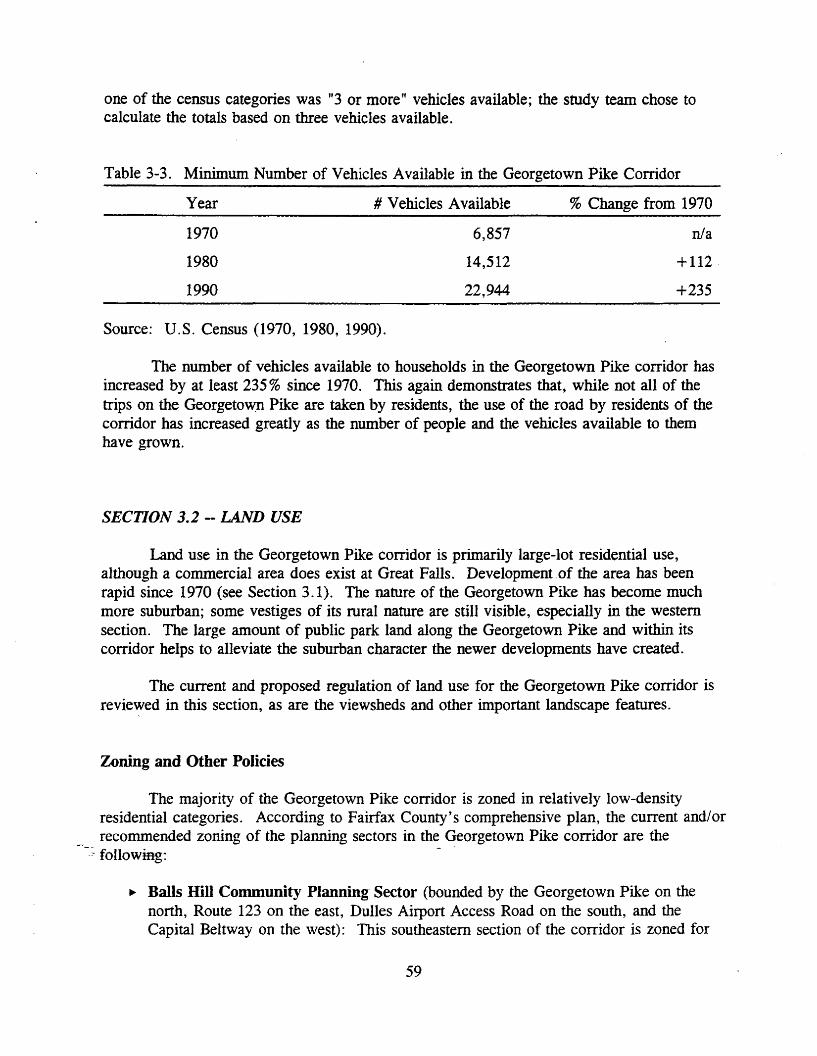
one of the census categories was "3 or more" vehicles available; the study team chose tocalculate the totals based on three vehicles available.
Table 3-3. Minimum Number of Vehicles Available in the Georgetown Pike Corridor
Year # Vehicles Available % Change from 1970
1970 6,857 n/a
1980 14,512 +112·
1990 22,944 +235
Source: U.S. Census (1970, 1980, 1990).
The number of vehicles available to households in the Georgetown Pike corridor hasincreased by at least 235% since 1970. This again demonstrates that, while not all of thetrips on the Georgetown Pike are taken by residents, the use of the road by residents of thecorridor has increased greatly as the number of people and the vehicles available to themhave grown.
SECTION 3.2 -- LAND USE
Land use in the Georgetown Pike corridor is primarily large-lot residential use,although a commercial area does exist at Great Falls. Development of the area has beenrapid since 1970 (see Section 3.1). The nature of the Georgetown Pike has become muchmore suburban; some vestiges of its rural nature are still visible, especially in the westernsection. The large amount of public park land along the Georgetown Pike and within itscorridor helps to alleviate the suburban character the newer developments have created.
The current and proposed regulation of land use for the Georgetown Pike corridor isrevie~ed in this section, as are the viewsheds and other important landscape features.
Zoning and Other Policies
The majority of the Georgetown Pike corridor is zoned in relatively low-densityresidential categories. According to Fairfax County's comprehensive plan, the current and/orrecommended zoning of the planning sectors in the Georgetown Pike corridor are the
-:. following: -
.. Balls Hill Community Planning Sector (bounded by the Georgetown Pike on thenorth, Route 123 on the east, Dulles Airport Access Road on the south, and theCapital Beltway on the west): This southeastern section of the corridor is zoned for
59

one or 0.5 acre per dwelling unit, although there is some zoning allowing 0.25 to0.33 acre per dwelling unit near the road.
.. Potomac Palisades Community Planning Sector (bounded by the Potomac River onthe north, Arlington County on the east, the Georgetown Pike on the south, andDifficult Run on the west): This northeastern portion of the corridor is zoned not lessthan one acre per dwelling unit east of the Beltway and five acres per dwelling unitwest of the Beltway.
.. Spring Hill Connnunity Planning Sector (bounded by the Georgetown Pike on thenorth, the Capital Beltway on the east, the Dulles Airport Access/Toll Road andRoute 7 on the south, and Old Dominion Drive and Towlston Road on the west):This south-central portion of the corridor is primarily zoned at one acre per dwellingunit except in the western portions, which are zoned either large-lot (two acres perdwelling unit) or estate (five acres or more per dwelling unit).
.. Riverfront Community Planning Sector (bounded by the Potomac River on thenorth and east; Route 193 and Beach Mill Road on the south; and River Bend Road,Seneca Road, and the Loudoun County line on the west): This northernmost sectionof the corridor is composed of large portions of park lands. The remaining land iscurrently zoned at two acres per dwelling unit but is proposed to be zoned to five toten acres per dwelling unit.
.. Springvale Community Planning Sector (bounded by Beach Mill Road on the north,Seneca Road and River Bend Road on the east, the Georgetown Pike and Route 7 onthe south, and the Loudoun County line on the west): This northwestern section ofthe corridor is primarily zoned at two acres per dwelling unit, with some sectionsproposed for five to ten acres per dwelling unit. Some existing subdivision land iszoned at 0.5 to one acre per dwelling unit.
.. Hickory Community Planning Sector (bounded by the Georgetown Pike on thenorth, Old Dominion Dr.; Towlston Road, and Difficult Run on the east; Route 7 andthe Dulles Access/Toll Road on the south; and Hunter Mill Road and Route 7 on thewest): This section of the corridor is proposed to be rezoned mainly at two to fiveacres per dwelling unit, although sections in the corridor are currently zoned at one totwo acres per dwelling unit.79
The zoning in the Georgetown Pike corridor protects the Difficult Run watershed,especially in the central and northern sections, by requiring a minimum of two acres for eachdwelling unit. This protection by the county is now required under the Chesapeake BayPreservation Act, which does not allow any construction on steep slopes in important
-watersheds whose waters eventually feed into the Chesapeake Bay. The rest of the corridoris zoned at this large-lot level or to the level of the existing development, anywhere from 0.2dwelling unit per acre to four dwelling units per acre.
60

A number of other county policies affect development in the corridor. Right-of-wayrequirements in the site plan review process require that 90 feet be dedicated when newsubdivisions are placed on a minor arterial (two-lane). So, the dedication of a right-of-wayof 45 feet from the centerline of the Georgetown Pike is required of any development withland fronting on the road. Setbacks from the right-of-way line are additional; these setbacksare required under the Fairfax County Zoning Ordinance.
Other policies include provisions in the county's Public Facilities Manual.Countywide requirements for service drives along primary highways and for street lightshave been lifted for roads designated as Virginia byways in the county -- at the moment, theonly byway is the Georgetown Pike. The Board of Supervisors passed these changes so thatneither street lights nor service drives are required along the Georgetown Pike. This actionkeeps each development that is planned on land adjacent to the Georgetown Pike from havingto apply for a waiver of these regulations.
Landscapes and Viewsheds
The Great Falls National Park, Riverbend County Park, and the Northern VirginiaRegional Park Authority's park lands along the Potomac River all act as important regionalrecreational and scenic resources. The park land the Georgetown Pike traverses lends theroad a forested quality, especially near the Difficult Run and Scott's Run. These park landsare protected from development, but often lands right across the road can be developed orredeveloped.
There are very few truly rural agricultural views remaining along the GeorgetownPike. At the intersection with Springvale Road there is a barn and a field that can be seen'from the Georgetown Pike. The horse pastures at Madeira School and other locationsremind the traveler of the road's rural history. Any or all of these lands could bedeveloped -- the remnants of the rural character of the corridor could still be erased.
The special character of the Georgetown Pike as a road and as a corridor is in largepart provided by these rural scenic features. While some protective measures to maintainthese special characteristics are in place, many others need to be implemented to truly protectthe integrity of the Georgetown Pike corridor.
SECTION 3.3 -- PROTECTION TECHNIQUES
Many teclmiques have been used or suggested for use in maintaining the specificqualities that make a scenic road and its corridor special. Sources for the protectiontechniques presented here include The National Trust for Historic Preservation's SavingAmerica's Countryside and The Conservation Foundation's Creating Successful Communities:A Guidebook to Growth Management Strategies.
61

Comprehensive Planning and Zoning Techniques
The aesthetic quality of scenic roadways is easily compromised. Billboards,garish signs, poorly designed residential development, strip commercialdevelopment, and incompatible uses . . . can irreparably mar an otherwiseattractive landscape.80
The dangers of unregulated, or poorly regulated, development in the corridor of a scenicroad or byway are great. The most effective tool in allaying these dangers is strict zoningordinances used in tandem with overlay districts. Comprehensive planning, which illustrateshow a municipality sees itself developing in the near future, can be an effective way ofprotecting a scenic corridor's aesthetic qualities if it is implemented in the proper way.
Zoning devices such as large-lot or low-density residential zoning can help to keep aonce rural landscape from becoming urban; however, a poorly designed or executed large-lotsubdivision can still be damaging to the aesthetic qualities of a scenic corridor.
To work effectively, large lot zoning must usually be used in combination withregulations that accommodate market demand in other more suitable areas.Over-reliance on large lot zoning, however, often encourages land consumingand inefficient low-density sprawl. 81
Cluster zoning is another teclmique that could be used in areas of the GeorgetownPike corridor that are zoned primarily as large-lot residential. With the appropriateregulations, cluster zoning could be used to protect or screen the viewsheds of theGeorgetown Pike from additional residential development. Cluster zoning allows "flexibledesign and clustering of development in higher densities on the most appropriate portion of aparcel in order to provide increased open space elsewhere on the parcel. "82 So, in ascenario concerning the Georgetown Pike, a subdivision development could be clusteredtogether at a higher density away from the road, with a screen of trees and/or open space topreserve existing views along the road. Open space areas, however, need to be preservedthrough perpetual easements or other similar means lest they become targets for futuredevelopment.
Among the most effective zoning technique is the use of overlay districts. Thesedistricts add further restrictions and/or regulations to the development of land covered by theoverlay. The overlay district's regulations do not replace those of the conventional zoningon the land but merely add to the existing ordinance. Three types of protective overlaydistricts are discussed further on: the traditional historic district, the corridor overlaydistrict, and the agricultural/forestal district.
62

Currently Used Techniques
These protection techniques are already in use to some degree by Fairfax County inthe Georgetown Pike corridor. The county's use of some of these techniques could be moreformalized to make it easier for residents to understand their purpose and their benefits.
Agricultural/Forestal Districts
Protecting land by using agricultural/forestal districts temporarily places the landunder conservation and reduces its property tax assessment. This program is used by FairfaxCounty with approximately 323 acres of land in the Georgetown Pike corridor. 83 The mainproblem with this protection technique is that it does not put permanent restrictions on theuse of land. Also, it is a voluntary program -- a property owner could at any time requestremoval from the district and, if the request were granted, have the property developedaccording to its current zoning.
Historic District
A historic district is often established by a jurisdiction to attain architectural reviewauthority over a number of significant historic structures that are in danger of beingaesthetically degraded. "Historic district significance can be ascribed to a collection ofbuildings, structures, sites, objects and spaces that possess integrity of location, design,setting, materials, workmanship, feeling, and association. 1184
, In the Georgetown Pike corridor, one such historic district already exists. TheLangley Fork Historic District was established between 1980 and 1982 to protect not only thestructures within its boundaries but also the portion of the Georgetown Pike that ran throughit. One of the factors listed in the request for designation was: "the need to protect the areafrom adverse environmental influences including inappropriate improvements to theGeorgetown Pike. "85 While there are other significant sites in the Georgetown Pikecorridor, there do not seem to be any other concentrations of such buildings or sites thatwould warrant the establishment of other historic districts. A voluntary program of propertyinclusion along the Georgetown Pike could be used to create a linear historic district, but amore fitting technique might be the creation of a corridor overlay district.
Conservation and Preservation Easements
Conservation and preservation easements can also be used to place restrictions on landuse. An easement II is an agreement between a property owner and the holder of the
--e_ase~ent governing treatment of the property by current and future owners. 1186 AneasementIs"recorded in local land records (and with the state agency accepting the easement)so that no development occurs except that which is allowable under the easement's deedrestrictions.
63
In Virginia, preservation easements can be donated to the Virginia Department ofHistoric Resources (VDHR), and conservation easements can be given to VDCR or theVirginia Outdoors Foundation. These easements often allow for federal and/or state incometax incentives, often in addition to a lowering of the value of a property so that propertytaxes are not such a burden.
Techniques for Future Use
This section provides additional protection techniques that could be used by FairfaxCounty to protect the scenic quality of the Georgetown Pike corridor. However, some ofthese techniques are not currently allowed under Virginia law -- enabling legislation wouldhave to be written and passed into law for municipalities to use them.
Corridor Overlay District
In 1988, Virginia passed legislation permitting local jurisdictions to establishurbanand architectural design standards for major routes of tourist access to historic districts orsites (Section 15.1-503.2 of the Code of Virginia, which can be found in Appendix F). Thetown of Leesburg was the first to take advantage of this provision. The town designated aportion of Route 15 leading to Leesburg as a historic corridor overlay district.
The purpose of these historic corridor regulations is to implement the TownPlan goal of ensuring quality urban design compatible with Leesburg'shistoric, architectural and tourist resources through architectural control alongthe town's arterial routes to the Old and Historic District.87
Fairfax County could adopt a similar ordinance and implement a corridor district for theGeorgetown Pike.
Important components of a scenic corridor overlay district include architecturalguidelines, setbacks, height limitations, signage, vegetation control, and any other regulationsthat pertain to the protection of the special scenic qualities of that corridor. 88 While someof these components are already dealt with satisfactorily in the present Fairfax CountyZoning Ordinance, a thorough look at the Georgetown Pike corridor to analyze thesecomponents and to create a corridor overlay district could greatly strengthen the existingprotective measures.
Especially appropriate in the Georgetown Pike corridor would be a plan for county,~ VDOT, and adjoining property owners to set up vegetation guidelines for the corridor. The-lmportaneeof trees to the scenic nature of the roadway is great -- a formal way of protectingfuture views and providing for the continued existence of trees along the corridor is crucial.This plan could include the agricultural/forestal district as an option for large parcels of land.
64
Tax Incentives
There are many forms of tax incentives that provide property owners with additionalinducement to protect their land. Among them are federal charitable contribution taxdeductions and various local property tax incentives. The federal charitable contributiondeduction can be used in the following instances:
Taxpayers may deduct from their federal income tax the value of historicallyimportant land areas and certified historic structures donated to governmentsand other appropriate recipients for preservation purposes. Donation of partialinterests in such properties, e.g., easements, are also deductible. 89
In order to receive this tax deduction, the gifts must be given in perpetuity.
In many states, property tax benefits a local jurisdiction could offer range fromlowering the valuation of historic properties to lowering property tax rates for land underconservation or preservation easements. In Virginia, the constitution authorizes the GeneralAssembly to pass a general law for localities "to provide a partial exemption from local realproperty taxation ... of real estate whose improvements, by virtue of age and use, haveundergone substantial renovation, rehabilitation or replacement. ,,90 Otherwise, the GeneralAssembly is not authorized to enact any "local, special, or private law ... for theassessment and collection of taxes . . . . "91
The Constitution of Virginia also gives the General Assembly the power to pass lawsallowing localities to lower property tax rates for real estate devoted to agriculture,horticulture, forest, or open space uses. The agricultural/forestal district is an example ofthis -- a General Assembly act that allows for a lower tax rate on real estate placed in adistrict.
However, any reduction in value or tax rates can cost a jurisdiction much-neededrevenue. In order for these tax incentives to work, they must be part of an overall plan thatprotects certain important scenic corridors from degradation while providing additionalbenefits in more appropriate locations within the jurisdiction. This would help to balancerevenue and ensure the corridor's protection.
Transfer of Development Rights
The transfer of development rights (TDR) has been used as a preservation techniqueboth for agricultural land and in association with the air rights above existing buildings in
-_cities such as New York and San Francisco. The concept of the use of TDRs as apreservation tool is that "unused development rights of a parcel containing a historic buildingcould be transferred to another site. "92 A system of TDRs in the Georgetown Pike corridorcould consist of landholders selling the excess development rights of their property to adeveloper in another area specifically designated to receive these development rights. Thereceivers of the development rights could, therefore, build more on their land then the
65

present zoning allows, while the senders would profit from the transfer but also conserve theundeveloped portion of their land.
TDRs do require a high level of staff expertise to design and administer.93 Theyalso require a market -- there must be areas with development pressure where developmentrights are needed or else the program will not work. Before the TDR technique could beused in Virginia, the General Assembly would have to pass into law enabling legislation thatwould give municipal governments (or certain municipal governments) the right to set upTDR programs.
The protection afforded by TDRs is not in perpetuity -- a future change in the zoningof the conserved land could effectively negate the preservation of the property. As long asthe municipality continued its current zoning and preservation practices, however, this landwould be protected. TDRs have not been a very popular preservation technique in theUnited States because weak real estate markets and the availability of other zoning techniquesoften diminish their value. 94
Land Acquisition
As a protection technique, land acquisition is often the best protection that can beafforded a scenic corridor. Acquisition of lands in a scenic corridor by local, state, orfederal governments, or with the help of a private interest, can place sensitive land in thehands of those that are best able to control its development for the benefit of the public. Forexample, land in urban areas may be acquired or designated for open-space use bymunicipalities. This interest in open-space lands must be held for a minimum of five yearsbut can also be in perpetuity. 9S Governments can also work with land trusts to acquireland. 11A land trust holds land and other property rights for the benefit of the public andoften undertakes educational, recreational, and scientific activities. 1196
A revolving fund, which is usually a private endeavor but sometimes is organized bya state or local historic preservation agency, uses funds to purchase lands or properties -usually those that are in imminent danger of degradation or destruction -- on which strictlimits are imposed. These limits usually include deed restrictions that limit development onthe land. The properties are then sold to "sympathetic buyers who agree to manage,develop, or restore the properties in accordance with deed restrictions. 1197 The VirginiaHistoric Preservation Foundation provides such a revolving fund.
66

CHAPTER 4 - GEORGETOWN PIKE: TRANSCENDENT ISSUES
SECTION 4.1 -- HISTORIC PRESERVATION
Historic properties provide communities with a sense of identity and stability.Preserving these properties significantly contributes to the vitality of today 'scommunities and ensures that tangible reminders of the past will remain forfuture generations. 98
Historic preservation in the United States has been associated mainly with the saving ofimportant historical structures (i.e., buildings). As the field has grown, additional types ofproperties have been considered worthy of preserving. Archaeological sites, landscapes, andimportant uninhabited structures such as bridges, railroads, and roadways have beenpreserved. It is in this last category that the Georgetown Pike falls. The history of theGeorgetown Pike as a transportation corridor is what proponents feel makes it worthy ofpreservation.
The main preservation obstacle in many minds has been the standards to whichVDOT adheres when dealing with the Georgetown Pike. The first of these obstacles is thecontinued, but mistaken, belief by some that VDOT plans to expand the Georgetown Pike tofour lanes. A Commonwealth Transportation Board resolution from 1979 clearly states thatthe Georgetown Pike is to remain a two-lane road. In addition, the 20-year subregional planfor Northern Virginia lists the Georgetown Pike as a two-lane road. This plan, the NorthernVirginia 2010 Transportation Plan, was created in 1987-88 by citizens and local officialsfrom every northern Virginia jurisdiction.
Many aspects of historic preservation can and do affect the Georgetown Pike. Theeligibility of the road for listing in the National Register of Historic Places affects what canbe done to the road and its right-of-way, both of which are owned by VDOT. The treatmentof historic properties, the laws that enable and govern preservation, and sources of fundingfor preservation activities are all discussed in this section.
Virginia/National Register Listing
Preserving a historic property presumes actions to retain its special character. Beforepreserving a property, it may be wise to designate it -- usually this means listing it in theNational Register of Historic Places. This listing provides recognition of the importance ofthe property to the history of the United States as a whole or to a state or locality.
67

Definitions of Preservation
Preservation is a broad term and is used in conjunction with other tenus to formvarious meanings. The term preservation by itself can be defined as the act of keeping aliveor in existence, of making lasting; as the act of keeping safe from harm or injury, of saving;and as the act of keeping up or maintaining. A definition of preservation put forth by theNational Trust for Historic Preservation follows;
Generally, saving from destruction or deterioration old and historic buildings,sites, structures, and objects and providing for their continued use by means ofrestoration, rehabilitation, or adaptive use. 99
According to the wording of the General Assembly resolutions initiating this study,the importance of "preserving the historic character" is how preservation is addressed. Adefinition of historic preservation, on the other hand, takes the definition of preservation andattaches the importance of the past to it:
Historic preservation is the process of ensuring that places significant in thepast are protected and integrated into places for the present and future."?
This definition is interesting because of its emphasis on compatibility between the historiccharacter -- or nature -- of a place and its applicability to the present and future. Thehistoric character of a property is what can make it eligible for listing in the NationalRegister.
The National Register
The National Register of Historic Places is a nationwide inventory of properties thatare important because of their place in the history, architectural history, archaeology,engineering, and/or culture of the United States. To be listed in the National Register, aproperty must go through a designation process that is administered by each state's StateHistoric Preservation Officer (SHPO). In Virginia, the director of the Department ofHistoric Resources is the SHPO, and VDHR is the agency that reviews and acceptsnominations to the National Register (and to the Virginia Landmarks Register).
The nomination of a property -- which can be a building ~ a structure, a site, anobject, or a group of properties that form a district -- to the National Register is guided by
-_~ four criteria for eligibility:
Criterion A: Properties that are associated with events that have made a significantcontribution to the broad patterns of our history.
Criterion B: Properties that are associated with the lives of persons significant in ourpast.
68

Criterion C: Properties that embody the distinctive characteristics of a type, period,or method of construction or that represent a significant and distinguishable entitywhose components may lack individual distinction.
Criterion D: Properties that have yielded, or may be likely to yield, informationimportant in prehistory or history.101
In addition to meeting at least one of these criteria, a property must also have integrity in thefollowing areas: location, design, setting, materials, workmanship, feeling, and association.
For a property such as the Georgetown Pike, for which federal funds may be used,listing in the National Register would invoke federal review processes. The GeorgetownPike was declared eligible for designation to the National Register at the August 17, .1993,meeting of the State Review Board -- VDHR' s advisory body. The Georgetown Pike wasdeemed important regionally in the area of significance of transportation. Even though theroad has not actually been entered in the National Register, all review processes have beeninvoked because of the eligibility ruling, including the various ways it can be treated.
Treatment of Historic Properties
The purpose of "treating" a historic property is to physically safeguard it from harmor ruin. A treatment is the guiding philosophy of how to preserve a specific property.There are generally four types or areas of treatment for a historic property. These rangefrom total reconstruction of a nonexistent structure from drawings, documents, and otherrecords, to the rehabilitation of a property for present and future use. The four treatmentssuggested in the Secretary of the Interior's Standards for the Treatment of Historic Propertiesare the following: (1) preservation, which focuses on the maintenance and repair of existinghistoric materials and retention of a property's form as it has evolved over time; (2)rehabilitation, which acknowledges the need to alter or add to a historic property to meetcontinuing or changing uses while retaining the property's historic character; (3) restoration,which is undertaken to depict a property at a particular period of time in its history, whileremoving evidence of other periods; and (4) reconstruction, which recreates vanished ornonsurviving portions of a property for interpretive purposes. 102
In the case of restoration, there is no one particular time period in the road's historyto return to -- the road continues its historic use at the present time. As for reconstruction,Georgetown Pike is very much alive and existing today -- the rebuilding of an Indian trailwould obviously not be appropriate. The treatments of preservation and rehabilitation seemworthy _o~_!U~her examination.
The Secretary of the Interior's definition of preservation (as a treatment) is
the act or process of applying measures necessary to sustain the existing form,integrity, and materials of an historic property. Work, including preliminarymeasures to protect and stabilize the property, generally focuses upon the
69

ongoing maintenance and repair of historic materials and features rather thanextensive replacement and new construction. 103
There do not seem to be any "historicIt materials and/or features on the Georgetown Pike(excluding its lay on the land) that would require maintenance and repair. The physicalfeatures of the road -- its roadbed, pavement, guardrail, bridges, markings, and signs -- aretwentieth-century creations with no specific reference to the historical physical nature of theroad.
The only feature of the road that seems to meet this definition of preservation as atreatment is the "historic character" of the road. The way Georgetown Pike lays on theland -- its relationship to the natural topography -- is what defines its historic character. Therelationship to the natural and rural views and the mature trees directly beside the road definethe scenic character of the Georgetown Pike.
Further, the Secretary's standards state that II when a continuing or new use does notrequire additions or extensive alterations, Preservation may be considered as a .treatment. "104 This statement seems to suggest that another treatment might be moreappropriate for the Georgetown Pike, because its continuing use is as a primary highwayand, as such, the road will most likely require additions or alterations over time.
With this in mind, rehabilitation seems to be appropriate as a treatment for thephysical features of the Georgetown Pike.
Rehabilitation is defined as the act or process of making possible a compatibleuse for a property through repair, alterations, and additions while preservingthose portions or feature_s which convey its historical, cultural, or architecturalvalues.'?'
The Secretary's standards recommend rehabilitation as a treatment "when alterations oradditions to the property are planned for a new or continued use. 11106 It seems improper toassume that no changes are necessary for the Georgetown Pike's use as a road; the modemuse of roads is always changing. For the Georgetown Pike's continued use as a road,changes will be necessary -- for safety, maintenance, the types of vehicles using the road,and possible implementation of advanced vehicle/highway system components.
After reviewing the range of treatments available for use on the Georgetown Pike, it_~~ems that the rehabilitation treatment, regarding the safety of the traveled way androadsides-would be the most appropriate. Although preservation of the road's rolling natureis also important, this does not require treatment as much as a "hands off" approach. As atreatment is applied to the Georgetown Pike, the project will be subject to a number offederal preservation laws and their associated regulations.
70

Effects of Eligibility -- Preservation Laws
There are a number of federal laws that regulate the effects that federal undertakingscan have on historic properties. Of these laws, Section 106 of the National HistoricPreservation Act of 1966 (NHPA), Section 4(0 of the Department of Transportation Act of1966, and the National Environmental Policy Act of 1969 will impact many projectsproposed for the Georgetown Pike, now that it has been declared eligible for listing in theNational Register.
National Historic Preservation Act of 1966
The National Historic Preservation Act of 1966, the most far-reaching preservationlaw, established a number of programs to help save historic properties in the United States.The main components of NHPA are the creation of the National Register of Historic Placesand the National Historic Landmarks Program; the recognition of state programs and thedesignation of SHPOs; preservation fund allocations; creation of the Advisory Council onHistoric Preservation (ACHP) and its Section 106 review process; and Section 110, whichgoverns the preservation of federally owned properties. The most important facet of NHPAas it affects the Georgetown Pike is Section 106.
Section 106 is "the provision of the National Historic Preservation Act of 1966 thatrequires the head of a federal agency financing or licensing a project to make a determinationof the affect of the project on property in or eligible for the National Register of HistoricPlaces. "107 (See Appendix G.) An overview of the procedures for this process provides aninsight into the method of review of projects proposed for the Georgetown Pike by VDOT.The main source for this overview was Veronica M. Kelly's report for the VirginiaTransportation Research Council entitled, Virginia Department of Transportation Compliancewith Section 106 of the National Historic Preservation Act.
The agencies that will usually be involved in the Section 106 process are VDOT,VDHR, the state FHWA office, and possibly the ACHP. The main goal of this reviewprocess is to keep any National Register or National Register-eligible properties from beingdamaged. So, the first step involves locating any of these properties. If no properties arelocated, the review process is complete. If there are significant properties, the next step is todetermine whether or not the project will have any effect on these properties.
Using the Criteria of Effect in Section 106 (see Appendix H), the agency (FHWA orVDHR) will determine if there is an effect:
An-undertaking has an effect on a historic property when the undertaking mayalter characteristics of the property that may qualify the property for inclusionin the National Register. For the purpose of determining effect, alteration tofeatures of the property's location, setting, or use may be relevant dependingon a property's significant characteristics and should be considered. 108
71

If no effect is found, then the Section 106 process is complete with the approval of theSHPO. If effects are found, then a further review is necessitated.
This further review involves applying the Criteria of Adverse Effects (see AppendixH) to the project and property:
An undertaking is considered to have an adverse effect when the effect on ahistoric property may diminish the integrity of the property's location, design,setting, materials, workmanship, feeling, or association. 109
Again, if no adverse effect is found, the review process ends by sending a summary of theprocess to the ACHP or by having the ACHP review the results in a 30-day time period.
If one or more adverse effects are found, a mitigation process is activated involvingthe FHWA and the SHPO. This usually results in a compromise solution that keeps theadverse effect of the project from harming the property. The agencies develop a . Memorandum of Agreement (MOA) delineating what steps will be taken to avert the adverseeffect. If all parties (including the ACHP) agree to the MOA, then the process is complete.
The most common mitigation procedures are avoidance and data recovery. Avoidancemeans redesigning a project so that it does not affect the historic property. Data recoveryusually means collecting archaeological data before construction commences -- in otherwords, collecting as much information about the history of the property as is possible beforeit is disturbed. This is the process, more or less, that VDOT will have to follow when usingfederal funding. An agreement between the Secretary of Natural Resources and the Secretaryof Transportation requires VDOT projects to go through the state's environmental reviewprocess to identify any impact on historic properties.
Section 4(f) of the Department of Transportation Act of 1966
Section 4(0 of the Department of Transportation Act of 1966 does not allow federalfunding or approval of any transportation project that makes use of a significant historicalsite (or parks, wildlife areas, recreation areas, etc.) unless there is no feasible alternative todoing so and the project has been planned to minimize the damage to the property to theutmost extent. (See Appendix I.) In this act, the "use" of a site includes indirect effects thatwould substantially impair its value. Compliance with Section 4(f) is usually coordinatedwith the Section 106 review process.
For instance, if the Section 106 review process showed that there would be an effecton.a.property due to a transportation project, Seetion 4(f) would kick in and planning for itsprovisions would be triggered. Much like the Section 106 review process, certain regulatoryand administrative measures were implemented that limit the number of cases which requirea full undertaking of the Section 4(0 compliance procedures.
72

National Environmental Policy Act of 1969
The National Environmental Policy Act of 1969 clearly states that it is the policy ofthe federal government, in cooperation with state and local governments, to "preserveimportant historic, cultural, and natural aspects of our national heritage, and maintain,wherever possible, an environment which supports diversity and a variety of individualchoice. 11110 (See Appendix J.) The main means for achieving this policy directive isrequiring all major federal actions to have an environmental impact statement (EIS).
The regulatory aspect of this law is carried out by the national Council onEnvironmental Quality, which requires that a draft EIS be prepared as part of the Section 106review process.
Virginia's Role
The integration of the EIS, the Section 106 review process, and the Section 4(f)compliance process is well established. This integration is necessary so that major projectsare not delayed indefinitely. Integration of these processes usually occurs at the state level.The Commonwealth of Virginia is a key player in most of the federal preservation-relatedreview processes. VDHR is the lead agency for review of a project that might affect aproperty listed in or eligible for the National Register.
Pursuant to federal law, the Department reviews all federally funded, licensedor sponsored projects in Virginia to assess the impact of these projects on
. significant cultural resources. The timely review, discussion and negotiationthat are at the heart of this process most often produce a mutually satisfactorysolution that minimizes any harmful effects the federal project might have onhistoric and archaeological resources. III
In addition, VDHR acts under state law to review any project involving state-ownedlandmarks, which would include the Georgetown Pike.
, The review processes are generally not adversarial. Rather, they serve as examplesof groups working together to form a solution amenable to all. The length of the processescan be quite short when no real disagreements occur.
Preservation Funding
There are a number of sources available to-fund preservation projects. Many of thesesources-are aimed primarily at the rehabilitation or renovation of historic buildings, not thepreservation of roads. The following sections look at only those sources that could providefunding for preservation work on the Georgetown Pike.
73
National Trust Funding
The National Trust for Historic Preservation offers grant and loan programs forvarious preservation activities.
The National Trust, a private, non-profit organization, is the only nationalpreservation organization chartered by Congress (in 1949) to encourage publicparticipation in the preservation of sites, buildings, and objects significant inAmerican history and culture. The National Trust acts as a clearinghouse ofinformation on all aspects of preservation, assists in coordinating efforts ofpreservation groups, provides professional advice on preservation, conductsconferences and seminars, maintains 17 historic properties as museums,administers grant and loan programs, and issues a variety of publications. 112
The technical/professional assistance and advice offered by the National Trust is aninvaluable resource for those interested in preservation, including those working on theGeorgetown Pike. .
The National Trust's Preservation Services Fund is intended to help increase the flowof information and ideas related to preservation. These grants are small, averaging $1,000 to$1,500, to a maximum of $5,000. Eligible activities for these grants include: hiringconsultants to undertake preservation planning or design projects, obtaining professionaladvice to strengthen management capabilities, sponsoring preservation conferences, designingand implementing innovative preservation education programs targeted to a specific audience,and undertaking other planning activities that will lead to implementation of a specificpreservation project. 113
Many of these activities could spur the implementation of protection techniques in theGeorgetown Pike corridor. One important aspect of these grants is that they must bematched at least dollar-for-dollar, requiring additional funding sources.
ISTEA Funding
A new and popular source of funding for transportation projects is the TransportationEnhancement Program. This is a funding source created by ISTEA. Through ISTEA'sSurface Transportation Program, 10% of the funds allocated to each state must be used fortransportation enhancements. In Virginia, this amounts to about $7 million a year through1996.
Funds from the historic preservation categories (see Section 2.1, EnhancementPundingr-can be used to inventory sites or to rehabilitate a historic property. This could beespecially useful when working on the Georgetown Pike. For additional information, onecan contact the Programming and Scheduling Division, VDOT, 1401 East Broad Street,Richmond, VA 23219.
74

State Funding
The Commonwealth of Virginia has a Threatened Properties Fund from which grantsare awarded to owners of landmarks that are seriously threatened -- which can includeanything from deterioration to the sale and/or destruction of a property. This program iscarried out by VDHR. VDHR also receives an annual subsidy from the federalgovernment's Historic Preservation Fund, which is funded through the leasing of off-shoreoil drilling. A part of these funds are funneled directly to the Certified Local Governments(CLGs) Program.
CLGs originated with the 1980 amendments to the National Historic Preservation Actof 1966. Local governments can be "certified" if they have set up a historic preservationcommission and a preservation program that meets the requirements set by the National ParkService and the state SHPO. Once a government is certified, it assumes a more formal rolein identifying, evaluating, and planning for the protection of the community's culturalresources -- the National Register listing process. CLGs are also eligible for technicalassistance from the SHPO to help carry out their preservation programs.
Special funding for CLGs is another benefit for local communities that are certified.At least 10% of Virginia's federal preservation funding must go to CLGs:
Certified local governments may apply for grants from a share of Virginia'sannual federal appropriation to carry out approved preservation projects, suchas additional survey of resources or preparation of local design guidelines forhistoric areas. 114
Fairfax County is not currently a CLG, although interest has been expressed to VDHR by thecounty. For more information on CLGs, contact the Virginia Department of HistoricResources, 221 Governor Street, Richmond, VA 23219.
Other Funding Sources
> Preservation can involve a number of tasks, from publishing a simple brochure or oralhistory interview to conducting a full-fledged inventory and master plan for a historicdistrict. The many federal and state sources of funding cover a variety of preservationactivities but often do not fully fund these activities. A local government often must assistthe funding of preservation projects in order to have them completed.
A source that can help to fill funding gaps is a local preservation group. These-igroups can sponsor fund-raising activities, whether it be direct mail solicitations, historic
property tours, or other community or tourism-related events. For example, the village ofWaterford in Loudoun County has several fund-raising festivals. The proceeds of theseevents go directly toward the continued preservation of their historic village and the farmlandthat surrounds it.
75

A final source that could be used for a number of different preservation activities isgrants from foundations. It is helpful to have contacts with these foundations; even withoutcontacts, a well-written, pertinent grant request can help to achieve the funds necessary forpreservation activities. For more information, one can contact The Foundation Center, 1001Connecticut Avenue, N.W., Washington, D.C. 20036.
SECTION 4.2 -- SAFETY AND TORT LIABILITY
The major concern for VDOT when designing and maintaining roadways is the safetyof the traveling public; any accident is a failure of the driver-vehicle-highway system. Also,the constant threat of being sued by an accident victim compels VDOT and theCommonwealth to adhere to certain standards and risk management strategies that keep thesafety of the public and the state's tax coffers from peril.
This section provides a brief description of tort liability and its related terminology, alook at safety and tort liability as they relate to the roads under VDOT's jurisdiction, adescription of risk management and the strategies adopted by VDOT in order to make itselfless liable in tort actions, and the relationship between tort liability and compliance withhistoric preservation laws.
Description of Tort Liability
(The following description of tort liability is based on a presentation given by WayneFerguson and Janice Alcee of the Virginia Transportation Research Council and Jim Wheelerof the Attorney General's office to the Advisory Committee on Highway Safety and Design
\ Standards in Scenic and Historic Areas in Richmond, Virginia, on May 4, 1993.)
A tort can be defined as a civil wrong or civil injury. A tort is not a criminal wrongor injury, which occurs when someone commits a criminal act against a person. A tortaction "seeks repayment for damage to property and injuries to an individual. "1l5 In a caseinvolving VDOT, a party (plaintiff) could seek damages for an accident that occurred on ahighway. This tort liability involves a party or parties (defendant) charged with beingnegligent. Negligence can be through either misfeasance, where the party improperlyperforms its duties, or nonfeasance, where the party fails to perform its duty. 116 So, toavoid liability in a suit seeking damages, VDOT must prove that it was not negligent in itsduty of care -- which includes providing safe roads for the traveling public.
-fu--Virginia, the principle of contributory negligence is exercised. Under contributorynegligence, if the plaintiff is found to be partly negligent in causing an accident -- whether ornot VDOT is also negligent -- the plaintiff is awarded no damages. Other states have asystem of comparative negligence, where a damage award is granted to the plaintiff only atthe percentage at which the defendant was found to be negligent.
76

A number of court cases have further defined what is necessary to bring a successfultort action against a person or an agency. In order to have a valid tort action, the followingelements must exist: '.
1. The defendant must have a legal duty to the plaintiff.
2. There must be a breach of duty; that is, the defendant must have failed toperform or to properly perform that duty.
3. The breach of duty must be a proximate cause of the accident that resulted.
4. The plaintiff must have suffered damages as a result.
Proving that these four elements apply is the burden placed on the plaintiff in a tort liabilitycase.117
Tort Liability and Road Design Factors
A tort action is usually undertaken because of an accident on a highway that resultedin injuries and/or damages. The action is predicated on the fact that the highway wasdefective or not safe enough and that this caused the accident. For VDOT, this means thatan existing highway could be faulted for tort liability purposes if it was determined by acourt to be unsafe. In a case VDOT might face, a plaintiff could not merely state that thehighway or highway feature was unsafe. The plaintiff would have to prove that the highwaywas unsafe or defective.
Specifically, to hold VDOT liable for a roadway defect, the plaintiff mustprove that the defect was a dangerous result of a VOOT employee's breach ofcare; the defect caused the plaintiff's injury; and VDOT had constructive oractual knowledge of the defect. 118
One area that will be under scrutiny in such a case is the design of the highway.
Highway Design
The design of a highway is often the basis for tort liability suits against VDOT. Thegeneral rule in court cases involving design issues is that the highway needs to have beenbuilt according to the accepted standards (usually the standards set by AASHTO) at the timethehighwaywas built. These standards change over time. So, for example, if a highwaywas built or reconstructed in 1967, it does not have to meet the 1990 AASHTO standards.
There are other sides to the issue of an appropriate design for a highway. A case inCalifornia demonstrates that changes in use can also affect liability:
77

Even when a highway has not been reconstructed, the adequacy of the existingdesign may be challenged when conditions have changed substantially such thata clear danger exists. For example, the state of California lost a tort case(Baldwin v. State) in which the omission of left-tum lanes was known to bedangerous. Although the highway was designed in accordance with applicablestandards, traffic conditions had changed over time. 119
This case demonstrates that it is not always enough for a highway to have been built to theappropriate standards of the time, but that DOTs have the responsibility of keeping theirroads safe in instances of deterioration, changes in use, and other factors that affect safety.One option is to reconstruct a highway, which in essence is building a new highway usingnew highway design standards.
For example, if VDOT were reconstructing a two-lane rural highway designed in the1940s, there would be certain safety features the designers would want to consider.Increasing lane width, shoulder width, and clear zone areas; straightening horizontal curves;and cutting or filling vertical curves to increase sight distance are just a few of these. Notall of these safety features need to be corrected in every situation. That could end up costingVDOT -- and the taxpayers -- a considerable sum. An example of an option follows:
At traffic volumes greater than 750 vehicles per day, reconstruction ofhorizontal curves can be more safety cost-effective than lane and shoulderwidening and can reduce vehicle operating costs and travel time.P"
This example demonstrates that a full reconstruction of an "unsafe" road is not alwaysnecessary to make it sufficiently safe for the public and to defend against liability in a tortaction.
An Altemative Approach
An approach that seems appropriate for use on the Georgetown Pike is to keep thetraveled way itself unchanged, with the exception of spot safety improvements whereaccident data or other relevant evidence warrants them. Improvements would be made to theroadsides to reach a reasonable level of safety -- all for the benefit of preserving the road'shistoric character for future generations. This approach could raise a number of problems,uincluding an effect on the nature of VDOT's duty of care. However, taking no action couldraise more problems. The idea for taking this approach is based on the wishes of citizensand other governmental agencies (the Fairfax County Board of Supervisors and VDHR) thatthe roadway be modified as little as possible.
TIre-desires of Fairfax County and VDHR are based on historic and aestheticconsiderations. The idea of aesthetics being part of the police powers of government -- thatis, providing for the health, safety, and welfare of the public -- appeared in the 1954 U.S.Supreme Court case Berman v. Parker, which dealt with urban renewal in the District ofColumbia.. Justice Douglas wrote in his opinion:
78

Public safety, public health, morality, peace and quiet, law and order -- theseare some of the more conspicuous examples of the traditional application ofthe police power to municipal affairs.... The concept of public welfare isbroad and inclusive. The values it represents are spiritual as well as physical,aesthetic as well as monetary. It is within the power of the legislature todetermine that the community should be beautiful as well as healthy. 121
This grant of power to municipal governments to control aesthetics has been applied througharchitectural review boards in historic districts. However, instances of governments placinghigher priority on aesthetic values than public safety are difficult to fmd.
Risk Management
Recognizing that there is no way to eliminate tort liability claims, many states haveadopted risk management programs. The main reasons for a DOT to have a riskmanagement program is to better provide for the safety of the users of highways and toprotect the taxpayers from uncontrolled damage awards in tort actions.
While a risk management program takes time and money to administer, the timeneeded by staff members to prepare for and take part in defending against a tort action couldbe much greater. The costs involved in staff salary and legal fees for court cases are alsohigh, so a well-defined program that tries to minimize liability is a logical and cost-effectivestep.
A simple way of looking at a risk management program is that it is a sensible meansof increasing safety and reducing liability with a relatively minor addition of work for agencystaff members. VDOT currently has a risk management process in place, so that it betterserves the public and keeps them -- and their pocketbooks -- safer.
Historic Preservation Laws
The need for understanding the relationship between tort liability and historicpreservation laws is especially apparent in the case of the Georgetown Pike. Since the Pikehas recently been declared eligible for designation in the National Register of Historic Placesand the Virginia Landmarks Register (see Section 4.1), both state and federal reviewprocesses for historic properties have come into effect. These review processes require thatany project affecting a historic property must not damage the property's historic character or
">: that such-damage be mitigated.
The effect of these reviews could mean a disparity between the requirements ofhighway construction standards and the opinions expressed in the historic preservation reviewprocess. The question this raises is which set of standards or opinions is the one to follow
79
to best protect the safety of the traveling public and the historic character of the road withoutopening up VDOT to liability and risk of tort actions.
The existence of requirements based on laws promoting historic preservationdoes not change the transportation agency's obligation to build and operatehighways that are safe to use. Nor can it relieve the agency of liability fornegligence in performing that mission. It can, however, affect a definition ofthe agency ~ s duty of care to highway users by sharpening the focus on thecharacter of the property involved, and so helping identify the range ofmeasures that are available to rehabilitate the structure or mitigate the effectsof rehabilitation. 122
Requesting a DOT to look at a range of measures is the ultimate effect of the preservationreview process. This has already occurred with a project on the Georgetown Pike.
VDOT had a project underway to make structural improvements to a nonhistoricalbridge on the Georgetown Pike when the National Register designation process was initiated.As a preemptive move, VDOT asked VDHR to review the project (a step that is requiredonce the road is declared eligible). VDHR responded by recommending -- not requiring -that VDOT place stone cladding on the bridge parapets that would harmonize with the stonepiers sitting next to the bridge.
This idea mirrors a solution that was recently used for the reconstruction of bridgeson the George Washington Memorial Parkway, a road listed in the National Register. In thissituation, VDHR did not tell VDOT not to change the bridge but instead asked it to take intoaccount the historic nature of the road and put a historical enhancement into the project.This step did not affect the safety implications of the project, so VDOT's duty of care in thissituation was not changed. The cooperation shown between VDHR and VDOT on this oneproject bodes well that future reviews will be a cooperative process -- not an adversarial one.
The continuing research on tort liability identified another important factor:
The most recent revisions and republications of "nationally recognizedhighway safety standards" show a preference for avoiding establishment ofprecise and mandatory criteria (or standards) for the design, construction,maintenance and operations of highway systems, and for providing ranges ofsuitable options from which engineering discretion can select the one toachieve a program objective. 123
The engineer's discretion and options alluded to require that even more stringent records of"the.process.used to determine the appropriate design of a highway improvements be madeand that a transportation agency define and follow its duty of care in an appropriate manner.
The processes involved when a property is placed in the National Register are notintended to keep VDOT from keeping the roads safe. Instead, the preservation review
80

processes will add another facet to VDOT's design process -- that of keeping the historiccharacter of this property intact while planning and designing safety improvements for theroadway.
81

82

CHAPTER 5 -- CONCLUSION AND RECO:M:MENDATIONS
If we believe that everyone who enters a neighborhood, whether as a tourist oras a resident, is a temporary occupant, the length of the stay being the onlydiscemable difference between the two, the importance of concentratingpreservation efforts on the physical fabric of the place is clear. 124
During the course of this study, the right-of-way of the Georgetown Pike wasdesignated by VDHR as eligible for listing in the National Register of Historic Places. Noother VDOT-maintained highway has been so designated. Accordingly, issues concerningthis designation were incorporated into this study.
In the field of historic preservation, there are several treatment philosophies for thepreservation of a historic property, depending on the circumstances and uses of the property.Of the major options available, it is recommended that "rehabilitation" be the acceptedtreatment philosophy for the Georgetown Pike.
Rehabilitation acknowledges the possibility that a historic property still in active usemay require alteration or addition to meet continuing or changing uses while retaining itsessential historic character. The essential historic characteristics of the Georgetown Pike areits location and its meandering alignment over rolling terrain.
The following specific recommendations are offered.
1. Configuration of the Georgetown Pike
A. The Traveled Way
Since 1979, it has been the position of the Commonwealth Transportation Board thatthe Georgetown Pike remain a two-lane facility. The traffic volume on this road wouldnormally indicate a need to widen it to four lanes, at least in some locations. However,there is a strong consensus among persons interested in historic preservation that suchwidening is not desirable. Angle and rear-end collisions, the most common types ofaccidents on the Georgetown Pike, are not associated with inadequate road width, but aremore typically the result of inadequate intersection design.
For these reasons, it is recommended that maintaining a good two-lane roadway, in--it§ current.location, continue to be the position of the Commonwealth Transportation Board
and VDOT, Fairfax County. and VDHR. No general widening, realignment, or relocation ofthe traveled portion of the road is recommended, except as provided below.
83

B. The Roadside
The inadequate shoulders of the Georgetown Pike cannot be ignored. Due to a lackof shoulders, an accident or disabled vehicle may block the road for extended periods, andpolice, fire, and rescue personnel have few safe places to position vehicles for emergencyresponse situations. Speed limit enforcement is also hampered. VDOT maintenancepersonnel have nowhere to push snow off the road, but keeping the road open is a highpriority for citizens who use it.
Because there are many run-off-road accidents involving fixed objects, an increasedclear zone would provide an opportunity for drivers to recover control of vehicles.
It is strongly recommended that plans be developed to improve the shoulders of theroad. In lieu of conventional paved shoulders, it is recommended that planning beundertaken by VDOT and Fairfax County, in cooperation with VDHR, to provide parkwaylike grass-covered aggregate and soil shoulders along both sides of the road.
Such grass shoulders would provide many of the safety benefits of paved shoulders,would be more attractive, would discourage their use as alternate travel lanes, yet wouldprovide sufficient support for occasional vehicular use. Analysis indicates that adding sixfeet of grass shoulders to each side of the road would yield as much as a 35 % reduction innonintersection accidents.
In planning for shoulder widening, these related roadside provisions should beincluded:
~ Pull-offs for tourist use to be provided at areas of unusual scenic or historic value(very important in making the road tourist-friendly);
~ Landscape plans for planting selected native tree species behind the relocated ditches(to maintain the character of the corridor past the life expectancy of existing maturevegetation and well into the twenty-second century); and
~ A path for cyclists and pedestrians, preferably separated from the road (this is not asimportant as pull-offs and tree planting but may also be desirable).
Partial funding of the design and implementation of these nonshoulder improvementsmay be available through the enhancement provisions of ISTEA.
C. Spot Safety Improvements
Periodic analysis of accidents occurring on the Georgetown Pike should be continuedto insure the early identification of safety problems. The accident history should also beused by decision-makers to determine the most appropriate entrance treatments for specificconditions.
84

Specific locations are identified in this report, and will continue to be identifiedthrough regular analyses of accident data, where spot improvements will be required toreduce localized hazards to the traveling public. All parties must recognize that such spotimprovements will be needed and that their design must be undertaken in a way to minimizethe adverse effects of these improvements on the character of the roadway.
Where controversies arise over the design of a particular improvement, it isrecommended that mediation, which has been used successfully in Virginia for some roadimprovements, be considered for use in the design process.
2. Street Entrances
It is recognized that the connection of new subdivision street entrances (and themeasures that provide for safe turning movements at these. new intersections) creates strongopposition from many citizens. It is recommended that several actions be taken to minimizethe number and the adverse effects of new entrances, in the priority order listed below.
A. Alternate Access
'Where feasible, it is recommended that Fairfax County and VDOT work together toensure that new subdivisions have no direct access to the Georgetown Pike but connectinstead to existing secondary roads in the area.
B. Joint Access
"Where new subdivision street entrances are unavoidable, it is recommended thatFairfax County and VDOT take strong measures to minimize the number of new entrances, byrequiring joint entrances, by requiring that new subdivisions accommodate the future accessneeds of adjacent undeveloped lands, and by using any other appropriate means.
c. Rural Entrance Standards
Because some new subdivisions will have no other lawful access, new entrances to theGeorgetown Pike will be required. However, as shoulders are widened, intersection sightdistance will improve. Therefore, the need for deceleration lanes and tapers for such streetentrances should be reduced.
Provided the Fairfax County Board of Supervisors so requests, and provided that--- _VDHRformally concurs, it is recommended that VDOT engineers, where a minimum stopping
sight distance of 300 feet is available or can be provided at no cost to the Commonwealth,adhere to VDOT's Minimum Standards for Entrances to State Highways (]989 edition) fornew entrances to the Georgetown Pike.
85

This document, intended primarily for application for rural highways, is consideredinadequate for use in urban areas such as Northern Virginia, where higher entrance standardsare employed. In consideration of Fairfax County's desire to maintain the road's existingcharacter, and in consideration of VDHR's designation of this road as eligible for listing inthe National Register of Historic Places, it is recommended that VDOT engineers recognizeand employ these "rural" standards on this road, on a trial basis.
This change would require most new cul-de-sac subdivision streets serving fewer than30 residential units (which is believed to include most subdivision activity in the area) tohave only an entrance radius, with no right-tum deceleration lane or taper.
VDOT's engineers, concerned for public safety and traffic capacity, prefer higherstandards. They have not recommended this course of action, nor have they recommendedagainst it. However, with a formal request from the Fairfax County Board of Supervisors toinitiate this change, and with formal concurrence of VDHR, VDOT could accede to thewishes of these govenunental agencies on a trial basis, for this road only.
However, should accident or other information show that the application of theseminimum standards led to safety or other traffic problems, their application should bediscontinued at the discretion of VDOT's Northern Virginia District Administrator.
D. Existing Entrances
Earlier evaluation of entrances resulted in a 1979 recommendation by the VirginiaDepartment of Highways, and supported then by the Georgetown Pike and Potomac RiverAssociation, that the entrance from Langley Lane to the Georgetown Pike be closed.
Although the major construction project proposed at that time was dropped, thisminor street, with its very limited sight distance, is still a problem entrance. It isrecommended that Fairfax County, with the cooperation of VDOT, give strong considerationto closing or abandoning the Langley Lane entrance.
3. The Corridor
Fairfax County has requested, and VDHR has concurred, that only the right-of-way ofthe Georgetown Pike be designated as eligible for listing in the National Register of HistoricPlaces. Some observers of this process note that, while preservation of the right-of-way mayserve a useful purpose, the roadway structure is not very historic. Instead, it is a mid-
--.:. twentieth-century adaptation of what probably began as an animal trail.
The preservation of the road itself does little to preserve the scenic characteristics ofthe corridor, which include the public and private properties within view of the road.Without action to preserve and protect these lands, all that might remain of the scenic andhistoric Georgetown Pike could be the roadway's lay on the land.
86

The preservation of private lands is much more difficult than the preservation of landsowned by public agencies. However, as these lands continue to develop, the accommodationof increased traffic volumes and increased turning movements will continue to modify theGeorgetown Pike's roadway.
It is recommended that Fairfax County, in cooperation with VDHR, seriously consideradditional corridor protection schemes that would control and preserve the views along thecorridor. Only by preserving the scenic qualities of the land is preservation of the roadlikely to succeed.
4. Alternative Transportation Corridors
Current VDOT and Fairfax County plans include highway improvements on:
.. Route 7 (widening to six lanes from Leesburg to the Dulles Toll Road);
.. Interstate 495 (adding a fifth lane, most likely an HOV lane);
.. Fairfax County Parkway (widening to four and six lanes from the Dulles TollRoad to Route 7); and
.. Dulles Toll Road (adding an HOV lane from Route 28 to 1-495).
In addition to these improvements planned by public agencies, an extension of the DullesToll Road to Leesburg is scheduled for construction by a private corporation.
Each of these improvements would improve conditions for motorists in the affectedareas and could have an effect on traffic volume on the Georgetown Pike. However, from abrief evaluation of these planned improvements viewed in the context of the continuedresidential and commercial development in western Fairfax and Loudoun Counties, it appearsthat none of them alone, nor all of them together, is likely to have a significant, long-termeffect, in reducing traffic on the Georgetown Pike.
It is recommended that Fairfax County, VDOT, and the Virginia Department of Railand Public Transportation continue to examine alternatives for improving highways, transit,and ridesharing opportunities and to work to broaden the acceptance of telecommuting as analternative to commuting.
5. The Administrative System
Suggestions have been made that the Georgetown Pike be transferred from thePrimary System to the Secondary System of State Highways to provide opportunities forrestricting through-truck traffic or to limit other traffic.
87

Historically, this road was designed and constructed for commercial hauling betweenLeesburg and the port of Georgetown. For most of its considerable history, the road servedprimarily for the mobility of through traffic, and only in the past few decades has access tolocal lands become a significant traffic volume factor.
Route 193 is functionally classified as a rural major collector (west of Bullneck Run)and as an urban minor arterial to its eastern end. It meets criteria for a primary highway,and it accommodates a traffic volume upwards of 20,000 vehicles per day.
It is not appropriate, either from a historical perspective or from the perspective oftoday's transportation needs, that through traffic be restricted. It is recommended that theroad remain in the primary system.
88

NOTES
1. Pethtel, Ray D. 1993. Tending transportation and history. Virginia Department ofTransportation (VDOT) Bulletin, June, p. 2.
2. Cooke, Elizabeth Miles. 1977. The history of the old Georgetown Pike. Annandale:Charles Baptie Studios. Various pages; Fairfax County History Commission.November 1992. Georgetown Pike: historic byway or commuter bypass? Fairfax.
3. American Association of State Highway and Transportation Officials (AASHTO).1990. A policy on geometric design of highways and streets. 3rd ed. Washington,D.C. p. 1.
4. Transportation Research Board (TRB). 1985. Highway capacity manual. SpecialReport No. 209. Washington, D.C. p. 1-3.
5. Ibid.
6. AASHTO, pp. 90-91.
7. VDOT. Transportation Planning Division. 1989. Virginia statewide highway plan:Northern Virginia District (CD-9). Richmond. p. 6.
8. Code oj Virginia, 1950, Title 33.1, §33.1-35.
9. VDOT. September 15, 1988. Procedures for considering requests for restrictingthrough trucks on secondary highways.
10. VDOT, Virginia statewide highway plan, p. 6.
11. Cottrell, B.H. February 1990. An operating guide for the control of residential cutthrough traffic. VTRC Report No. 90-TAR2. Charlottesville: VirginiaTransportation Research Council. p. 9.
12. Kuhlman, Richard S. 1986. Killer roads: From crash to verdict. Charlottesville:The Michie Company. p. 29.
13. Zegeer, C. V., J. Hummer, D. Reinfurt, L. Hurf, and W. Hunter. 1986. Safetyeffects of cross-section design for two-lane roads. Vols. I and II. Publication No.
-- fJIWA-RD-87-008 and 009 . Washington.rD.C.: U.S. Department of Transportation(U.S. DOT). (Summarized in Appendix C, pp. 248-255 of TRB Special Report No.214, 1987.)
14. U.S. DOT. 1992. Environmental programs and provisions: Intermodal SurfaceTransportation Efficiency Act of 1991. Publication No. FHWA-PD-92-012.Washington, D.C. p. 1.
89

15. VDOT. 1993. Transportation allocation formulae study (draft). Richmond.
16. VDOT. 1993. Transportation enhancement program. Richmond. pp. 3-7.
17. Patten, R.S., and H. Hiemstra. 1993. Enhancing America's communities: Anationwide survey of the transportation enhancements provisions of ISTEA.Washington, D.C.: Rails-to-Trails Conservancy.
18. U.S. DOT. July 27, 1993. Use of in-kind match and private capital on enhancementprojects. Office of Engineering Memorandum. Washington, D.C.
19. VDOT. Management Services. October 28, 1992. VDOT department policymemoranda manual. Department Policy Memoranda Number 1-2. Richmond.
20. VDOT. Richmond District Traffic Engineering Section. 1992. The guidebook forentrance permit evaluation. 2nd ed. Richmond. Chap. I, p. 6.
21. Milliken, J.G. June, 1993. Presentation to the General Assembly AppropriationsCommittee. Richmond.
22. VDOT, Guidebook for Entrance Permit Evaluation, Chap. I, p. 1.
23. Code of Virginia, 1950, Title 15.1, §15.1-446.1.
24. U.S. DOT. 1982. Access management guidelines for streets and highways. ReportNo. FHWA-IP-82-3. Washington, D.C.
25. Fairfax County. 1990. The comprehensive planjor Fairfax County, Virginia: Policyplan for Fairfax County. Volume 1. Fairfax. p. 20.
26. Fairfax County, Comprehensive Plan, p. 21.
27. VDOT, Guidebook for Entrance Permit Evaluation, Chap. I, p. 2.
28. U. S. DOT, Access Management for Streets and Highways.
29. Ibid.
30. Ibid.
31. Koepke, F.J., and H.S. Levinson. 1992. Access management guidelines for activity-~ c.~~!ers. NCHRP Report 348. Washington,_D.C. p. 97.
32. AASHTO, p. 797.
33. Koepke and Levinson, p. 97.
90

34. AASHTO, p. 790; Neuman, T.R. 1985. Intersection channelization design guide.NCHRP Report 279. Washington, D.C. p. 61.
35. Koepke and Levinson, p. 97.
36. Ibid.; VDOT, Guidebookjor Entrance Permit Evaluation, Chap. V, p. 1.
37. Neuman, p. 61.
38. Ibid.
39. Koepke and Levinson, p. 97.
40. AASHTO, p. 798.
41. Ibid.
42. Ibid.
43. U. S. DOT, Access Management for Streets and Highways.
44. AASHTO, p. 790.
45. Koepke and Levinson, p. 97.
46. Neuman, p. 63.
47. Cottrell, B.H. 1981. The development of criteria for the treatment of right tummovements on rural roads. VHTRC Report No. 81-R45. Charlottesville: VirginiaHighway and Transportation Research Council. p. 3.
48. Ibid.
49. Ibid.
50. . VDOT. Traffic Engineering Division. 1989. Minimum standards of entrances tostate highways. Richmond. p. 10.
51. AASHTO, p. 828.
52. Koepke and Levinson, p. 98.
--- )3". -l]-.S. DOT, Access Management for Streets-and Highways.
54. Fairfax County, Comprehensive Plan, pp. 78~ 80.
55. Ibid., p. 80.
91

56. Fairfax County, Comprehensive Plan, map insert.
57. Fairfax County Board of Supervisors. March 9, 1992. Amendment to the FairfaxCounty comprehensive plan. Fairfax.
58. U.S. DOT. April 27, 1992. National scenic byways program. Washington, D.C.
59. U.S. DOT. April 27, 1992. Interim scenic byways program: Policy and grantapplication procedure. Washington, D.C. p. 1.
60. Code of Virginia, 1950, Title 33.1, §33.1-63.
61. Code of Virginia, 1950, Title 33.1, §33.1-64.
62. Virginia Department of Conservation and Recreation (VDCR). 1989. 1989 Virginiaoutdoors plan. Richmond. pp. 130-131.
63. Code of Virginia, 1950, Title 33.1, §33.1-63.
64. VDCR. 1993. A guide for Virginia byway management. Richmond. pp.4-5.
65. Commonwealth Transportation Board. June 22, 1992. Memorandum of agreementbetween the Commonwealth Transportation Board and the Virginia Department ofConservation and Recreation related to the administration of the Scenic Highway andVirginia Byway Program. Richmond. p.2.
66. Commonwealth Transportation Board, pp. 3-4.
67. Commonwealth Transportation Board, p. 8.
68. Ibid.
69. U.S. DOT. 1988. Scenic byways. Publication No. FHWA-DF-88-004.Washington, D.C. p. 5-3.
70. Ibid., p. 1-3.
71. Ibid., p. 5-15.
72. New York Department of Environmental Conservation. c. 1987. Preserving NewYork State scenic roads: A guide to designation. Albany. p. 1.
7"3. New York Department of Environmental Conservation, p. 4.
74. California Department of Transportation. 1988. Guidelines for the officialdesignation of scenic highways. Sacramento. p. 5.
92

75. Mastran, Shelley. 1990. Protection techniques for scenic byways: Four case studies.National Trust for Historic Preservation for the U.S. Department of Transportation.Publication No. FHWA-ED-90-024. Washington, D.C. p. 19.
76. American Society of Landscape Architects for the U.S. Department of Transportation.Creative landscape design solutions in scenic byways. Publication No. FHWA-ED90-029. Washington, D.C. p. 17.
77. U.S. DOT, Scenic Byways, p. 7-1.
78. Ibid., p. xii.
79. Fairfax County. 1991. The comprehensive plan for Fairfax County, Virginia: Areaplans. Vols. 3 and 4. Fairfax, various pages.
80. Mantell, Michael A. for The Conservation Foundation. 1990. Creating successfulcommunities: A guidebook to growth management strategies. Washington, D.C. :Island Press. p. 92.
81. Mantell, p. 180.
82. Mantell, p. 181.
83. Fairfax County. 1993. Agricultural/forestal districts. Fairfax.
84. National Trust for Historic Preservation (National Trust). 1990. Landmark yellowpages. Washington, D.C.: The Preservation Press. p. 60.
85. Fairfax County. Langley Fork Historic District: Fairfax County, Virginia. Fairfax.p. 15.
86. Stokes, Samuel N. with A. Elizabeth Watson, et al. 1989. Saving America'scountryside: A guide to rural conservation. Baltimore: The Johns HopkinsUniversity Press. p. 179.
87. Town of Leesburg. 1992. H-2 corridor ordinance in town of Leesburg zoningordinance. Leesburg. p. 59.
88.
89.- --
;- -90.
91.
Mastran, p. 59.
National Trust, Landmark yellow pages, p. 106.
Code of Virginia, 1950, Constitution of Virginia, Article X, §6(h).
Code of Virginia, 1950, Constitution of Virginia, Article IV~ §14(5).
93

92. Andrews, Gregory E. 1987. Historic preservation in the private sector. In TheAmerican mosaic: Preserving a nation's heritage, ed. Robert E. Stipe and AntoinetteJ. Lee. Washington, D.C.: US/ICOMOS. p. 215.
93. Mantell, p. 183.
94. Andrews, p. 216.
95. Code of Virginia, 1950, Title 10.1, §10.1-1701.
96. Stokes, et aI, p. 193.
97. Ibid., p. 198.
98. Virginia Department of Historic Resources (VDHR). Informational brochure onVDHR. Richmond.
99. National Trust. 1993. Landmark yellow pages: Where to find all the names,addresses, facts, and figures you need in preservation. 2nd ed. Washington, D.C.:The Preservation Press. p. 124.
100. Ramirez, Constance W. Spring 1993. Class Syllabus, Preservation Planning,University of Virginia School of Architecture. Charlottesville.
101. National Trust, Landmark yellow pages, 2nd ed., p. 199.
102. U.S. Department of the Interior. 1992. The Secretary of the Interior's standards forthe treatment of historic properties 1992 . Washington, D. C.
103. Ibid.
104. Ibid.
105. Ibid.
106. Ibid.
107. National Trust, Landmark yellow pages, 2nd ed., p. 125.
108. Kelly, Veronica M. 1988. Virginia Department of Transportation compliance withSection 106 of the National Historic Preservation Act. VTRC Report No. 89-R9.S-~arlottesville: Virginia Transportation Research Council. p. 9.
109. Kelly, p. 55.
110. Public Law 91-190, January 1, 1970; 42 U.S.C. 4371 et seq.
111. VDHR.
94

112. National Trust, Landmark yellow pages, 2nd ed., p. 191.
113. National Trust. Preservation services fund. ~ashington, D.C.
114. VDHR.
115. TRB. 1987. Designing safer roads: Practices for resurfacing, restoration, andrehabilitation. Special Report No. 214. Washington, D.C. p. 175.
116. Ibid., p. 177.
117. TRB. 1983. Practical guidelines for minimizing tort liability. NCHRP Synthesis ofHighway Practice No. 106. Washington, D.C. p. 6.
118. Culkin, Donald S., Adam C. Thackston, and Willard A. Stanback. 1988.Assessment of tort liability risk management in the Virginia Department ofTransportation. VTRC Report No. 89-R8. Charlottesville; Virginia TransportationResearch Council. p. 3.
119. TRB, Designing Safer Roads, p. 181.
120. Ibid., p. 7.
121. Wright, Robert R., and Morton Gitelman. 1982. Land use: Cases and materials.St. Paul: West Publishing Company. p. 1193.
122. Netherton, Ross D.. 1991. Supplement to legal aspects of historic preservation inhighway and transportation programs. Legal Research Digest, 20, p. 35.
123. Ibid.
124. Stipe, Robert E. 1987. The next twenty years. In The American mosaic:Preserving a nation's heritage, ed. Robert E. Stipe and Antoinette J. Lee.Washington, D.C.: US/ICOMOS. p. 278.
95

96
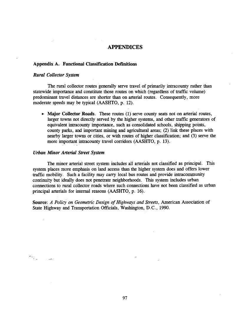
APPENDICES
Appendix A. Functional Classification Definitions
Rural Collector System
The rural collector routes generally serve travel of primarily intracounty rather thanstatewide importance and constitute those routes on which (regardless of traffic volume)predominant travel distances are shorter than on arterial routes. Consequently, moremoderate speeds may be typical (AASHTO, p. 12).
.. Major Collector Roads. These routes (1) serve county seats not on arterial routes,larger towns not directly served by the higher systems, and other traffic generators ofequivalent intracounty importance, such as consolidated schools, shipping points,county parks, and important mining and agricultural areas; (2) link these places withnearby larger towns or cities, or with routes of higher classification; and (3) serve themore important intracounty travel corridors (AASHTO, p. 13).
, .
Urban Minor Arterial Street System
The minor arterial street system includes all arterials not classified as principal. Thissystem places more emphasis on land access than the higher system does and offers lowertraffic mobility. Such a facility may carry local bus routes and provide intracommunitycontinuity but ideally does not penetrate neighborhoods. This system includes urbanconnections to rural collector roads where such connections have not been classified as urbanprincipal arterials for internal reasons (AASHTO, p. 16).
Source: A Policy on Geometric Design of Highways and Streets, American Association ofState Highway and Transportation Officials, Washington, D.C., 1990.
97
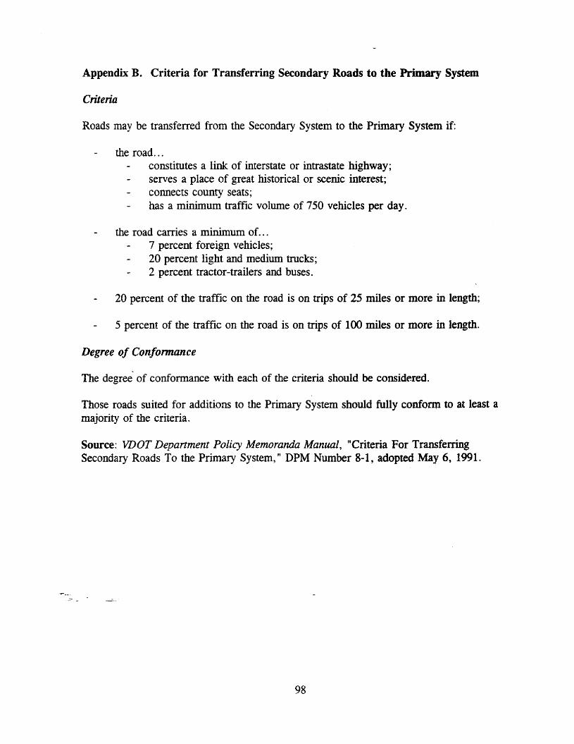
Appendix B. Criteria for Transferring Secondary Roads to the Primary System
Criteria
Roads may be transferred from the Secondary System to the Primary System if:
the road ...constitutes a link of interstate or intrastate highway;serves a place of great historical or scenic interest;connects county seats;has a minimum traffic volume of 750 vehicles per day.
the road carries a minimum of. ..7 percent foreign vehicles;20 percent light and medium trucks;2 percent tractor-trailers and buses.
20 percent of the traffic on the road is on trips of 25 miles or more in length;
5 percent of the traffic on the road is on trips of 100 miles or more in length.
Degree of Conformance
The degree of conformance with each of the criteria should be considered.
Those roads suited for additions to the Primary System should fully conform to at least amajority of the criteria.
Source: VDOT Department Policy Memoranda Manual, "Criteria For TransferringSecondary Roads To the Primary System," DPM Number 8-1, adopted May 6, 1991.
98
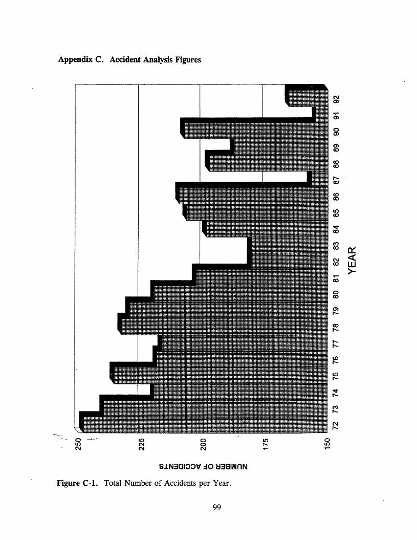
Appendix C. Accident Analysis Figures
C\Ien
~
en
0en
enCD
CDCD
f"-CD
<0CD
1.0CD
~CD
('I)co 0::N <CCD W
>-~
CD
0CD
enr-
CD.....f"-r-
<0t-
1.0r-
~......
('I')......
N......
0 It> 0 l() 0LO N 0 ,.... 1.0N N N T- T-
Sl.N3010:>\f:lO ~38wnN
Figure C-l. Total Number of Accidents per Year.
99

Appendix C (continued)
ooN
oo..-
S.lN3C.:>:>V :10 ~38wnN
oIt)
Nm
-r-m
0(J)
enCO
ex>ex>
,....CO
toCD
It)CO
~CO
~CO a=N <tCO w
>---CO
0CO
enr-
eor-
r-,....
CDr-
Il)r-
vr-
Mr-
Nr-
an 0N
Figure C-2. Number of Injury and Property Damage Accidents per Year.
100
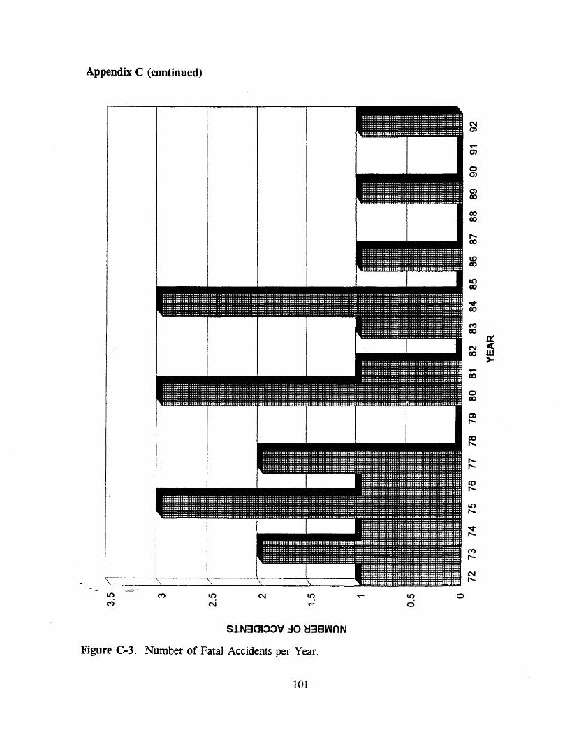
Appendix C (continued)
;111111111111111111111111111111111111111111111111111111
SlN301:J:J":l0 ~38wnN
Figure C-3. Number of Fatal Accidents per Year.
101
NQ)
'If"'"0)
00)
0)co
coco,......co
(0co
anco
vco
('I')CD
a:N c(CD W
>~
co
0CD
0),.....
CD,.....
,.....,.....
<0,.....
Il),.....
v,.....
('l'),.....
N,.....

Appendix C (continued)
(I)to2wo(3o~u,
00N ....
ZW
~wa.
0 -J >- C/) 0:: 0::t- -c
~::> z >- 0 w 0
z ~ 0 0~ 0:: J:
Z 0 WC/)
·z0
w z 0 t-o -c 0:: a::: z « c ~ 0 w z 0w w ::s :J a:: Q.. -c ....J w~ a:: w u, ...J
~a:::
CL. f/) 0 C> I
0 W Cl u, ....J 0 Z I « 0::« I a w (J en 0 ~ w z -cw I «CD ~ ., U I c .,
~C/) ::r: w
0 rn C/) z rn w 0::0 ~
0 w 0 en 00- WX
Z x -0 enu: u.. en
Figure C-4. Percentage of Accidents by Collision Types.
102

Appendix C (continued)
tn0 t-
ZC")W0U0c(
t-OW.,m0
0 CN W><iLu.0I-ZW0a:w
0 0-~
~ -J WU~
..J W 0
en ::J 0 C>Z 0::: :c 0 w 0.. 0
~ W 0::: o en wC) (/) > -c z >- W ....J 0:::Ci) >- 0 :J W ~ W - W
~W C> u, ::::i ~ ~ :c
i= I- ~~ z 00::: ::::> -c
::I: -c Qla..
Figure C-5. Types of Fixed Objects Hit in Accidents.
103

Appendix C (continued)
aeo
a<0
ol()
aM
oN
o
0::wJ:tO
zG~
iszocwo
~ ~o ::;)Z enC/)
>n::o
Sl.N3CI:>:>'<f :10 l.N3:>~3d
Figure C-6. Percentage of Accidents Occurring by Surface Condition.
104
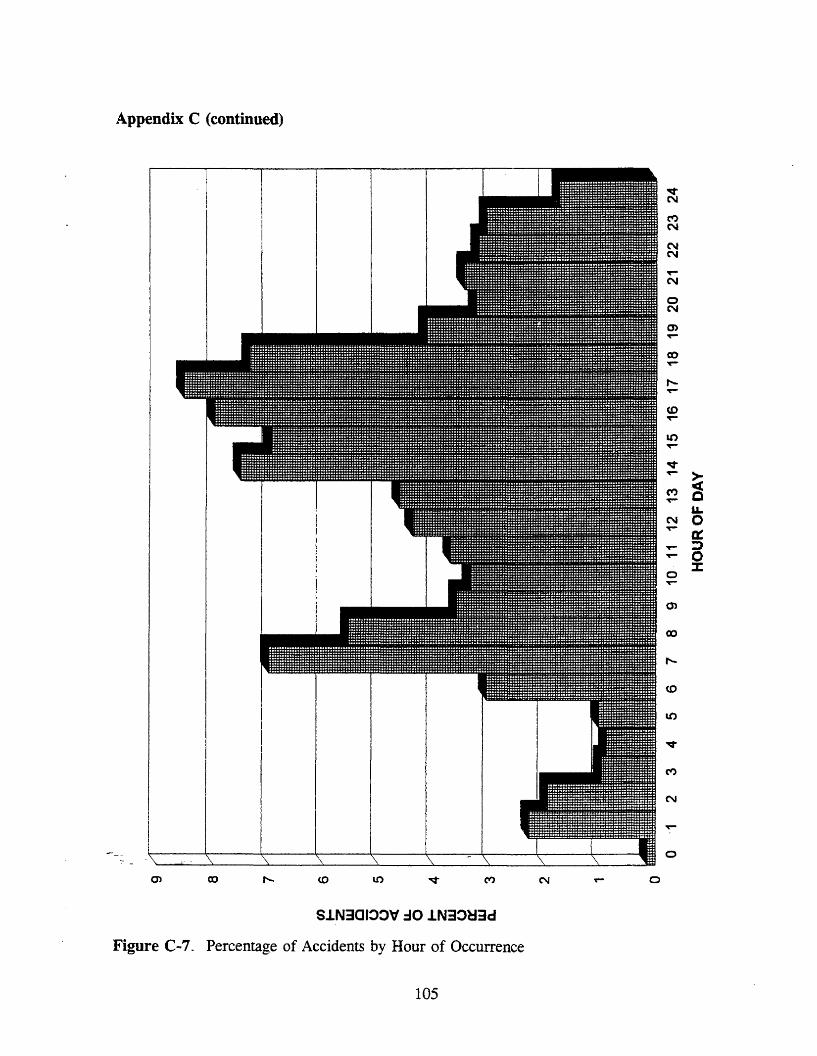
Appendix C (continued)
S.1N301:>:>ld :JO .1N3:>~3d
Figure C-7. Percentage of Accidents by Hour of Occurrence
105
oq-N
(")N
NN
or-N
0N
enor-
coor-
t-or-
<.0or-
10or-
Vor- >('t) ·ct0r- e
11.N 0~ a:or- J0r- o
Z00r-
O)
co
,.....,
<.0
lO
v
(")
N
0r-
o
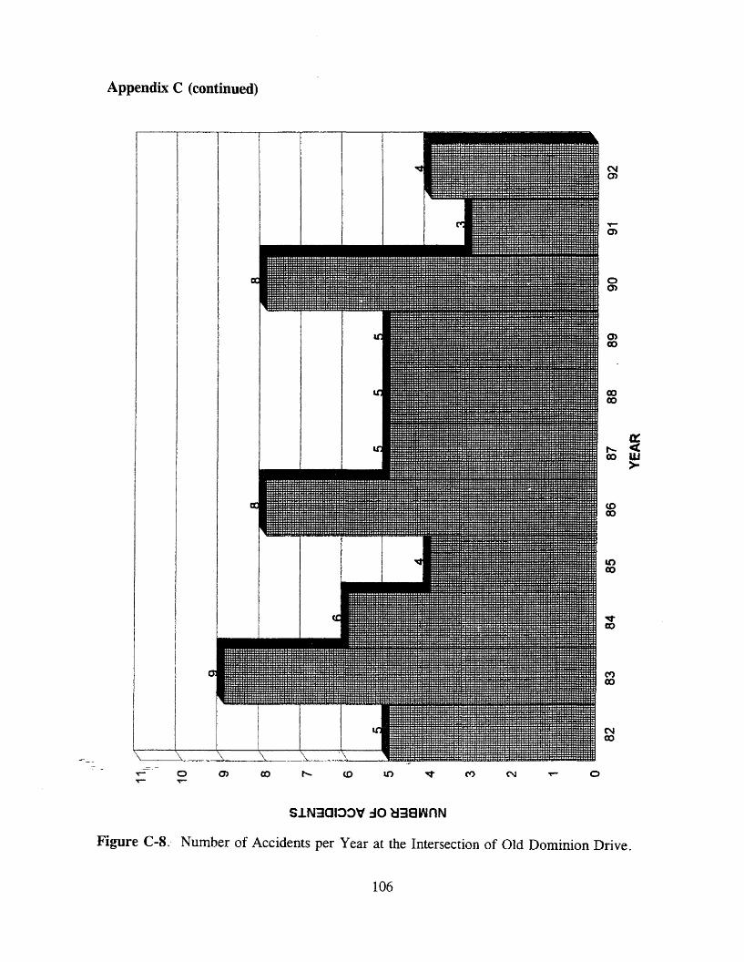
Appendix C (continued)
C'\Im
om
0>CD
CDCD
r--- ~CD W
>
(0CD
LC)CD
Sl.N3CI::>::>\f :10~38wnN
Figure C-8. Number of Accidents per Year at the Intersection of Old Dominion Drive.
106

Appendix C (continued)
Nen
oen
(J)co
I'- ~co W
>
coco
L()eo
Sl.N301:>:>lf :10 lJ38WnN
Figure C-9. Number of Accidents per Year at the Intersection of River Bend Road.
107
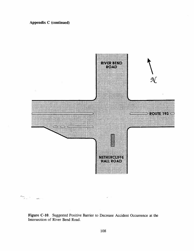
Appendix C (continued)
Figure C-IO. Suggested Positive Barrier to Decrease Accident Occurrence at theIntersection of River Bend Road.
108

Appendix C (continued)
o0>
0>co
coco
a:r-- «co w
>
coco
S.lN3CI:>:>'f :10 ~38wnN
Figure C-l1. Number of Accidents per Year at the Intersection of Swinks Mill Road.
109

Appendix C (continued)
SiN301:>:>" .:10 H38wnN
N o
o0)
coco
t- ~co w
>
LOco
Nex>
Figure C-12. Number of Accidents per Year at the Intersection of Harvey Road.
110

Appendix C (continued)
SlN301:>::>V:l0 H38wnN
Figure C-13. Number of Accidents per Year at the Intersection of Route 7.
111

Appendix C (continued)
Nm
om
coco
a::...... c:(CD W
>
<.0co
LOco
Nco
Sl.N3CI:>:>'V :10~38wnN
Figure C-14. Number of Accidents per Year at the Intersection of Douglas Drive.
112

Appendix C (continued)
-or- --0or- --- or- en
SJ.N3QI~::>'d .:10 ~38wnN
o
Nen
aen
OlCD
CDCD
0::I' «CD w
>
<0co
It)co
C\Ico
Figure C-15. Number of Accidents per Year at the Intersection of Mackall Avenue.
113

Appendix C (continued)
S~N301:l:l":l0 ~38wnN
Figure C-16. Number of Accidents per Year at the Intersection of the Ramp from EBGeorgetown Pike to NB 1-495.
114
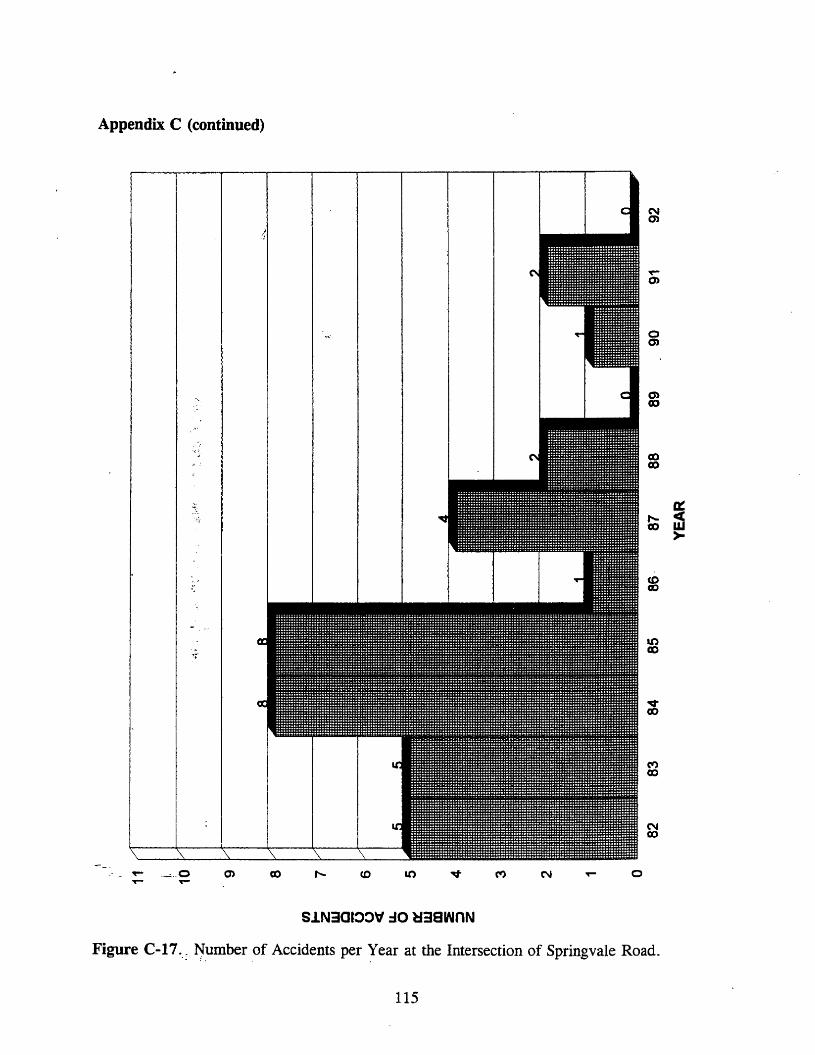
Appendix C (continued)
S~N3al:>O\f :10 ~38wnN
Figure C-17.-: fiumber of Accidents per year at the Intersection of Springvale Road.
115
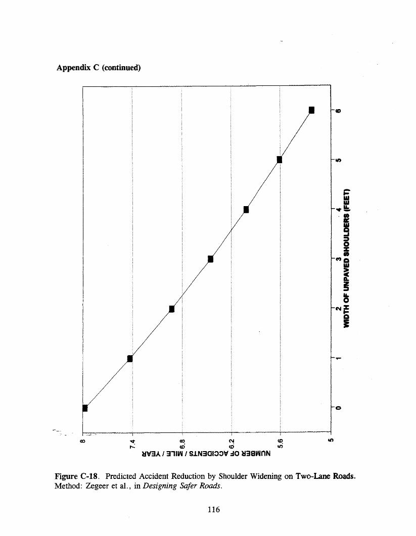
Appendix C (continued)
-
co ~ ~ N ~~ m ~ ~
H\f3A I 311W I SJ.N3CIOOV :JO H3BwnN
o
Figure C-18. Predicted Accident Reduction by Shoulder Widening on Two-Lane Roads.Method: Zegeer et aI., in Designing Safer Roads.
116

Appendix D. Criteria for Designation as a Virginia Byway
In order to be considered for designation as a Virginia Byway, a segment of road mustsubstantially meet the tests of the following physical criteria:
1. The route provides important scenic values and experiences.
2. There is a diversity of experiences, as in transition from one landscape scene toanother.
3. The route links together or provides access to significant scenic, scientific, historic orrecreational points.
4. The route bypasses major roads or provides opportunity to leave high-speed routes forvariety and leisure in motoring.
5. Landscape control or management along the route is feasible.
6. The route affords opportunities for the provision of features which will enhance themotorist's enjoyment of the byway and provide for the improved safety of the visitor.
7. The route contributes to good distribution within elements of the Scenic Highway andVirginia Byway system.
8. . Local government(s) has/have initiated zoning or other land-use controls, so as toreasonably protect the aesthetic or cultural value of the highway.
Source: A Guidefor Virginia Byway Management, Department of Conservation andRecreation, Commonwealth of Virginia, Richmond, Reprint, July 1993, pp. 4-5.
117
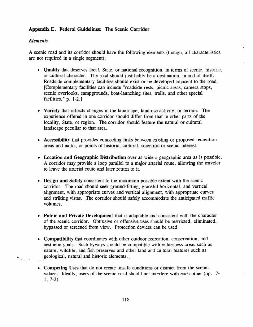
Appendix E. Federal Guidelines: The Scenic Corridor
Elements
A scenic road and its corridor should have the following elements (though, all characteristicsare not required in a single segment):
~ Quality that deserves local, State, or national recognition, in terms of scenic, historic,or cultural character. The road should justifiably be a destination, in and of itself.Roadside complementary facilities should exist or be developed adjacent to the road.[Complementary facilities can include "roadside rests, picnic areas, camera stops,scenic overlooks, campgrounds, boat-launching sites, trails, and other specialfacilities, " p. 1-2.]
~ Variety that reflects changes in the landscape, land-use activity, or terrain. Theexperience offered in one corridor should differ from that in other parts of thelocality, State, or region. The corridor should feature the natural or culturallandscape peculiar to that area.
~ Accessibility that provides connecting links between existing or proposed recreationareas and parks, or points of historic, cultural, scientific or scenic interest.
~ Location and Geographic Distribution over as wide a geographic area as is possible.A corridor may provide a loop parallel to a major arterial route, allowing the travelerto leave the arterial route and later return to it.
~ Design and Safety consistent to the maximum possible extent with the sceniccorridor. The road should seek ground-fitting, graceful horizontal, and verticalalignment, with appropriate curves and vertical alignment, with appropriate curvesand striking vistas. The corridor should safely accommodate the anticipated trafficvolumes.
~ Public and Private Development that is adaptable and consistent with the characterof the scenic corridor. Obtrusive or offensive uses should be restricted, eliminated,bypassed or screened from view. Protection devices can be used.
~ Compatibility that coordinates with other outdoor recreation, conservation, andaesthetic goals. Such byways should be compatible with wilderness areas such asnature, wildlife, and fish preserves and other land and cultural features such asgeological, natural and historic elements._
~ Competing Uses that do not create unsafe conditions or distract from the scenicvalues. Ideally, users of the scenic road should not interfere with each other (pp. 71, 7-2).
118

Appendix E (continued)
Controls
A variety of devices have been developed and used to control scenic highway corridors:
~ Wider than normal right-of-way.~ Outright acquisition of corridor areas.~ Fee acquisition and leaseback to adjacent owners.~ Acquisition of scenic or conservation easement.It- Local zoning (county or city).It- State zoning.It- Scenic highways corridor reservations.~ Designation of special conservation or corridor districts.It- Comprehensive planning.~ Restrictive covenants in deeds (p. 7-4).
Source: Scenic Byways, U.S. Department of Transportation, Federal HighwayAdministration, Washington, D. C., July 1988.
119
Appendix F. Historic Corridor Ordinance and Enabling Legislation
Enabling Legislation
§ 15.1-503.2. Preservation of historical sites and areas in counties and municipalities. - A. 1. The governing body of any county or municipality may adopt an ordinance settingforth the historic landmarks within the county or municipality as established by the VirginiaLandmarks Commission, and any other buildings or structures within the county ormunicipality having an important historic, architectural or cultural interest, and any historicareas within the county or municipality as defined by § 15.1-430 (b), amending the existingzoning ordinance and delineating one or more historic districts, adjacent to such landmarks,buildings and structures, or encompassing such historic areas, or encompassing parcels ofland contiguous to arterial streets or highways (as designated pursuant to Title 33.1,including § 33.1-41.1 of that title) found by the governing body to be significant routes oftourist access to the county or municipality or to designated historic landmarks, buildings,structures or districts therein or in a contiguous county or municipality. Such amendment ofthe zoning ordinance and the establishment of such district or districts shall be in accordancewith the provision of Article 8 (§ 15.1-486 et seq.) of this chapter. The governing body mayprovide for an architectural review board to administer such ordinance. Such ordinance mayinclude a provision that no building or structure, including signs, shall be erected,reconstructed, altered or restored within any such historic district unless the same isapproved by the architectural review board or, on appeal, by the governing body of suchcounty or municipality as being architecturally compatible with the historic landmarks,buildings or structures therein. . . .
Source: Code of Virginia, § 15.1-503.2.
120

Appendix G. Section 106 of the National Historic Preservation Act of 1966
SEC. 106. The head of any Federal agency having direct or indirect jurisdiction over aproposed Federal or federally assisted undertaking in any State and the head of any Federaldepartment or independent agency having authority to license any undertaking shall prior tothe approval of the expenditure of any Federal funds on the undertaking or prior to theissuance of any license, as the case may be, take into account the effect of the undertakingon any district, site, building, structure, or object that is included in or eligible for inclusionin the National Register. The head of any such Federal agency shall afford the AdvisoryCouncil on Historic Preservation established under Title II of this Act a reasonableopportunity to comment with regard to such undertaking.
Source: Public Law 89-665, October 15, 1966; 16 U.S.C. 470 et seq.
121
Appendix H. The Section 106 Process: Evaluating Effects
800.9 Criteria of Effect and Adverse Effect
(a) An undertaking has an effect on a historic property when the undertaking may altercharacteristics of the property that may qualify the property for inclusion in the NationalRegister. For the purpose of determining effect, alteration to features of the property'slocation, setting, or use may be relevant depending on a property's significant characteristicsand should be considered.
(b) An undertaking is considered to have an adverse effect when the effect on a historicproperty .may diminish the integrity of the property's location, design, setting, materials,workmanship, feeling, or association. Adverse effects on historic properties include, but arenot limited to:
(1) Physical destruction, damage, or alteration of all or part of the property;(2) Isolation of the property from or 'alteration of the character of the property'ssetting when that character contributes to the property's qualification for the NationalRegister;(3) Introduction of visual, audible, or atmospheric elements that are out of characterwith the property or alter its setting;(4) Neglect of a property resulting in its deterioration or destruction; and(5) Transfer, lease, or sale of the property.
(c) Effects of an undertaking that would otherwise be found to be adverse may beconsidered as being not adverse for the purpose of these regulations:
(1) When the historic property is of value only for its potential contribution toarcheological, historical, or architectural research, and when such value can besubstantially preserved through the conduct of appropriate research, and such researchis conducted in accordance with applicable professional standards and guidelines;(2) When the undertaking is limited to the rehabilitation of buildings and structuresand is conducted in a manner that preserves the historical and architectural value ofaffected historic property through conformance with the Secretary's "Standards forRehabilitation and Guidelines for Rehabilitating Historic Buildings"; or(3) When the undertaking is limited to the transfer, lease, or sale of a historicproperty, and adequate restrictions or conditions are included to ensure preservationof the property's significant historic features.
Source: 36 C.F.R. Part 800 (1987).
122
Appendix I. Section 4(f) of the Department of Transportation Act of 1966
Sec. 4(t). Maintenance and enhancement of natural beauty of land traversed bytransportation lines.
It is hereby declared to be the national policy that special effort should be made to preservethe natural beauty of the countryside and public park and recreation lands, wildlife andwaterfowl refuges, and historic sites. The Secretary of Transportation shall cooperate andconsult with the Secretaries of the Interior, Housing and Urban Development, andAgriculture, and with the States in developing transportation plans and programs that includemeasures to maintain or enhance the natural beauty of the lands traversed. After August 23,1968, the Secretary shall not approve any program or project which requires the use of anypublicly owned land from a public park, recreation area, or wildlife and waterfowl refuge ofnational, State, or local significance as detetmined by the Federal, State, or local officialshaving jurisdiction thereof, or any land from an historic site of national, State, or localsignificance as determined by such officials unless (1) there is no feasible and prudentalternative to the use of such land, and (2) such program includes all possible planning tominimize harm to such park, recreational area, wildlife and waterfowl refuge, or historic siteresulting from such use.
Source: Public Law 89-670, October 15, 1966; 49 U.S.C. 1653(f).
123

Appendix J. National Environmental Policy Act of 1969
Sec. 101 (b) In order to carry out the policy set forth in this Act, it is the continuingresponsibility of the Federal Government to use all practicable means, consistent with otheressential considerations of national policy, to improve and coordinate Federal plans,functions, programs, and resources to the end that the Nation may
(1) fulfill the responsibilities of each generation as trustee of the environment forsucceeding generations;(2) assure for all Americans safe, healthful, productive, and esthetically and culturallypleasing surroundings;(3) attain the widest range of beneficial uses of the environment without degradation,risk to health or safety, or other undesirable and unintended consequences;(4) preserve important historic, cultural, and natural aspects of our national heritage,and maintain, wherever possible, an environment which supports diversity and avariety of individual choice;(5) achieve a balance between population and resource use which will permit highstandards of living and a wide sharing of life's amenities; and(6) enhanced the quality of renewable resources and approach the maximum attainablerecycling of depletable resources.
Sec. 102. The Congress authorizes and directs that, to the fullest extent possible: (1)the policies, regulations, and public laws of the United States shall be interpreted andadministered in accordance with the policies set forth in this Act, and (2) all agencies of theFederal government shall
(C) include in every recommendation or report on proposals for legislation and othermajor Federal actions significantly affecting the quality of the human environment, a detailedstatement by the responsible official on
(i) the environmental impact of the proposed action,(ii) any adverse environmental effects which cannot be avoided should theproposal be implemented,(iii) alternatives to the proposed action,(iv) the relationship between local short-term uses of man's enviromnent andthe maintenance and enhancement of long-term productivity, and,(v) any irreversible and irretrievable commitments of resources which wouldbe involved in the proposed action should it be implemented.
Source: Public Law 91-190, January 1, 1970; 42 U.S.C. 4371 et seq.
124

Appendix K. Joint Resolutions
SENATE JOINT. RESOLUTION NO. 235
Requesting the Department 01 Transportation to study Georgetown Pike.
Agreed to by the Senate, February' 25, 1993Agreed to by the House of Delegates, February 23, 1993
WHEREAS, the General Assembly has recognized the Importance of preserving thehistoric character of certain roads and highways within the Commonwealth by passinglegislation providing for the designation at such roads and highways as Virginia byways(Article 5 (§ 33.1·62 et seq.) of Chapter 1 of Title 33 of the Code of Virginia); and
WHEREAS, an important part of the character of Virginia byways is their originalalignment, adjacent structures, trees and other vegetation; and
WHEREAS, Georgetown Pike, located in Fairfax County, was designated as the firstVirginia Scenic and Historic Byway in 1973, and its preservation is now being threatened;and
V{HEREAS, the primary purpose of designating Virginia byways is to preserve theaesthetic and cultural character of roads leading to or within areas of historical, natural, orrecreational significance; and
WHEREAS, the goals of maximizing traffic flows, improving roadways to meet currenthighway engineering and safety standards, and requiring certain road Improvements inconjunction with adjacent development sometimes connlct with the goal ot preserving thecharacter of Virginia byways; and
WHEREAS, the Intermodal Surface Transportation Efficiency Act at 1991 (ISTEA) hasestablished a committee to review requirements for byways; and
WHEREAS, the Department of Transportation is currently studying .criteria fordesignation of byways and has established an advisory committee; now, therefore, be it
RESOLVED by the Senate, the House of Delegates concurring. That the Department ofTransportation be requested to study the Georgetown Pike.
The Department shall consider the tollowing issues as they relate to the GeorgetownPike:
(i) Identification of all statutory, regulatory, or publisbed engineering, construction,traffic, or safety standards that may be inconsistent with the purpose of maintaining theexisting or historic character of this byway;
(Ii) Identification and recommendation of alternatives to any engineering, legal, or otherrequirements ot standards that, it followed, would degrade the aesthetic. natural, or historiccharacter of Georgetown Pike; and
(iii) Identification of sources of funding available for preservation or improvements toalternative transportation corridors including those sources available under ISTEA and theNational Historic Preservation Act ot 1966;
The Department shall consider ISTEA, especially the environmental programs andprovisions of that act. as well as programs developed by the states of Maryland, Delaware.and Pennsylvania pursuant to ISTEA, in determining what alternatives and options may be
<-avanabte, _. - The-Department shall consult with the County of Fairfax and its office ofcomprehensive planning, and shall hold at least one public bearing in the County ofFairfax.
The Department shall complete its study ot the Georgetown Pike in time to submit itsfindings and recommendations to the Governor and the 1994 General Assembly as providedin the procedures of the Division of Legislative Automated Systems for processinglegislative documents.
125

Appendix K (continued)
GENERAL ASSEMBLY OF VIRGINIA-InS SESSIONBOUSE JOINT RFSOLtTnON NO. 411
Ap"eed to by the Rouse of Deleptel, February 18t 1113Ap"eed to by tile Senate, Febn1U)' 18, 1"3
WHEREAS, the General Assembly bu recacntted the Importance of preservtna tilehistoric: dwacter of certain roads and bl&bWQI wttbJD the Commonwealth by passiDileglslatloa provldlq for the deslpatloo of sudl roads ancI bllbwa~ II _VlrJInta byways(ArtIcle 5 (I 33.1-G et seq.) of Chapter 1 of nUe 33 of tbe Code of V1rIlDJ8>; and
WHEREAS, an Important part of the cbar8der ot V11'IiDIa byways Is their ort8laalallpDleot. adjacent structures, trees aod other veaetatJoo; aad
WHEREAS, Georaetowa Pike. located In FaIrfu County, W8I designated 81 the tlrstVIrginia SceoIc aDd 1Iistoric Byway In 1973. aDd Its presemtUoo II now beiDl threate.aed;and . .
WHEREAS. the primary purpose of deslpaUoa VIrJ1D1a byways 11 CD preserve theaestJletlc aDd cultural character of roeds leadloa to or wttlllo areas ot historical. natural. orrecreatlODlll sIpltIcance; and
WHEREAS, the pia of mulmIz1q tratflc 1I0ws. Improving roadways to meet currenthighway eqloeeJ1q aDd safety standards. and requlrtDl certalD road improvements InconJuDCtloD wtUl adJaceat developmeDI sometimes contlld with the .... ot preservlog thedlarader of Vlf'IIDla bywa~ 8DCl
WHEREAS, the IntermodaJ Surface TJ'B.DSPOrtatlon Emdeocy Ad of 1991 (ISTEA) hasestabllsbed a committee to review requirements for byways; and
WHEREAS, tbe Department 01 TransportatioD Is currently studylq criteria tordesJgnaUoo 01 byways and bas establJslled aD adVIsory committee; DOW. therefore, be It
RESOLVED by tbe Rouse of Delegates. tile Senate CODcurrlD& That the Department otTranspor1attoo be requested to study the GeorptoWD Pike.
De Department sbal1 coDSIder the foUowlnl Issues as they relate to the GeoraetownPike:
(I) IdeDtlftcatioo of all statutory, regulatory. or publlsbed eqIDeer1n& coostrucUon.trafftc or safety standards that may be 1DcoDsIsteat with the P1U'pOIe of malntaJD1n& theexistlD. or blstoric character of tb11 byway;
(II) IdeDUncaUoD aod recommendation of altematlves to any eqineerl.D& 1epI. or otherrequirements of standards that. If foUowed. would dep'ade the aesthetic. natural. or bJstoriccbaracter of GeofleloWD PIke; aDd
(W) IdeoWicatlOD of JOUrCeS of tundlD& available for praervaUon or Improvements toalteroatlve transportatloo corridors lDdudlq those sources avaUable UDder ISTF.A and tileNaUooaI IIIItortc Preservation Ad of 1968;
De Department sbaII consider ISl'EA. especially the environmental programs andprovllloas of tbat act. 81 weI1 ~~rograms developed by the states of MaryIaDd. Delaware.and PeontylvaaJa purswmt to ISTEA, In determlDfua wbat altematlves and optIoos may beavailable.
Tbe Depertment sball consult with the County of Fairfax and Its office of__._ compreileDSlve planoln& aDd sbaIl bold at least_ one pubUc bearl.og In the County of
~Falrfu;=--The Department sbaD complete Its study of tile Georgetown Pike In time to submit Itt
nndlnp and recommendations to the Governor aDd the 1194 GeneraJ Assembly as providedin the procedures of the Dlvtslon of LqtslaUve Automated Systems for the processlq otleg1slaUve documents.
126

Appendix L. Work Plan
PROPOSED WORK PLANfor
SJR 235 & HJR 411 (1993)
Study of the Georgetown Pike - Fairfax County
June 1-30:
Initiate contact with knowledgeable VDOT personnel to assemble backgrounddocuments and state information. Conduct field trip with selected VDOT personnel.
Initiate contact with selected citizens and county officials. Determine issues of speciallocal interest. Conduct field trip with selected community representatives.
July 1-31:
Advertise and conduct public hearing in Fairfax County. Prepare minutes of publichearing, including written communications received.
Identify and categorize issues. Include appropriate VDOT district, residency, and. division staff in this process.
August 1 - September 15:
Assess comments of citizens and officials.Define main issues.Propose and evaluate alternatives.
, Prepare draft report of study.
September 16-30:
Prepare final report.
october 1: -=---
Deliver final report to Policy Analysis.
127

Appendix M. Public Hearing
PUBLIC HEARINGRoute 193, Georgetown Pike, Fairfax County
Thursday, August 5, 1993, 7:00 p.m.Langley High School
6520 Georgetown PikeMcLean, Virginia
Speakers:
1.2.3.4.5.6.7.8.9.10.II.12.13.14.15.16.17.18.19.20.2l.22.23.24.25.26.27.28.
---~. _29.30.31.32.
David Ogle, VDOTGerald E. Fisher, VTRCDelegate Vincent F. CallahanSenator Janet D. HowellSupervisor Ernest J. BergerElizabeth Z. Wertz, McLeanHerb Becker, McleanJ.C. Censky, McleanEugene Methvin, McLeanHenry Ahari, McLeanRoss RowlandManning Gasch, McLeanFrank B. Crandall, McLeanJohn Adams, McLeanMary Ellen WestJohn Chomeau, McLeanMichael Gillette, Great FallsJoan Bliss, Great FallsRay AbbernathyThomas K. Moore, McLeanCornelius J. Golden, Jr., McleanAllen Muchnick, ArlingtonRichard Bliss, Great FallsRichard A. Poole, McLeanTim Hall, McLeanBrent Clarke, McleanJames Frazer, Great FallsDan Denning, Great Falls
_--Freston Shelton, McLeanSally Oldham, McleanBert NyeBruce McJilton, Great Falls
128
Appendix M (continued)
Written Comments:
1. Richard Peters, President, Great Falls Citizens Association2. W. Ross Rowland, Great Falls3. Jane Fragola, Great Falls4. Thomas K. Moore, Mclean5. Ted G. Berlincourt, McLean6. John Hamilton, McLean7. Cornelius B. Kennedy, McLean8. Edward A. Mainland, Mclean9. Nijole S. Vaitekunas, Great Falls10. Anna Marie Mulvihill, Vienna11. Glenn E. Wise, Mclean; Millicent T. Lang, Mclean, John W. Bowman and Grace
Bowman, Mclean12. Otis C. Deal, JI., VDOT Northern Virginia District13. Trish Bunn, Springfield, Virginia14. Marion H. Smoak, Mclean15. Linda Kolodziej, Conservation Chair, Fairfax Audubon Society16. David Ogle, VDOT Northern Virginia District17. Nathan H. Olshan, Mclean18. Young H. Chang, VDOT Fairfax Residency19. Delegate Jerry M. Wood, Warrenton, Virginia20. Milburn P. Sanders, Great Falls21. Frank D. Edwards, VDOT Northern Virginia District
129