Embed Size (px)
Citation preview
GeoL. Soc. MaLaYJia, BuLLetin 42, December 1998; pp. 119-128
Geophysical investigations of the hot spring occurrences in the Sungei Serai and Kampung Dusun Tua areas,
Hulu Langat, Selangor
MOHD ANuAR MD. RAZALI
Jabatan Penyiasatan Kajibumi Malaysia Peti Surat 1015
Jalan Sultan Azian Shah 30820 Ipoh, Perak
Abstract: At the request of the Director, Geological Survey Department of SelangorlW. Persekutuan, two geophysical surveys using regional gravity and transient electromagnetic (TEM) techniques were carried out at Hulu Langat area and Sg. Serai, Selangor. The objectives of the survey were to delineate major geological structures that may be associated with the occurrences of the hot springs in the area.
The regional gravity survey detected two major faults along part of Sungai Langat and Sungai Semenyih. These faults created a fractured zone. This fracture zone provided a conduit for the hot spring to seep through.
The TEM results indicate the presence of two conductive zones which are attributed to fractures within the bedrock. Future physical development at the sites should be implemented away from these conductive zones to avoid potential interference to these structures which have been identified as the pathways of the hot springs. Abstrak: Atas permintaan Pengarah Kajibumi SelangorlW. Persekutuan, dua survei geofizik dengan menggunakan kaedah graviti rantau dan 'transient elektromagnetic (TEM)' telah dilaksanakan di sekitar kawasan Hulu Langat dan Sg. Serai, Selangor. Objektif survei ini ialah untuk memetakan struktur geologi yang berkaitan dengan pembentukan kolam air panas.
Keputusan survei menunjukkan kaedah survei graviti rantau dapat mengesan dua struktur besar sesar di sepanjang Sungai Langat dan Sungai Semenyih. Sesar-sesar ini menghasilkan suatu zon rekahan. Zon-zon rekahan ini merupakan temp at pengeluaran air panas.
Keputusan survei TEM menunjukkan terdapatnya dua zon konduktif yang disebabkan rekahan di batuan dasar. Segala pembangunan yang akan dilakukan dikawasan zon konduktifini patut dielakkan untuk tidak mengganggu struktur geologi yang merupakan laluan sumber air panas ini.
INTRODUCTION
Two geophysical methods the gravity and the transient electromagnetic (TEM) methods, were used to investigate the occurrences of hot spring in the Hulu Langat area, Selangor. There are four known occurrences of hot springs within the survey area (Fig. 1). It is anticipated that there are major subsurface geological structures (faults) that may be associated with the occurrences of these hot springs. A regional gravity survey was initiated to identify and delineate these structures.
A detailed investigation using the transient electromagnetic (TEM) method was then carried out at the Sungai Serai hot spring site (Fig. 1). A similar investigation was done by Abd. Rahim (1996) at the Sungai Semenyih site. The two hot springs in nearby Dusun Tua have already been developed and were found to be unsuitable for detailed investigation. The primary objective of the TEM technique is to map in detail geological structures which are the source/pathway of the hot springs.
These structures should then be preserved whenever development takes place to avoid loosing the hot spring.
The geophysical investigations were undertaken at the request of the Geological Survey Department of SelangorlW. Persekutuan.
BASIC PRINCIPLE OF THE TEM TECHNIQUE
The transient-electromagnetic (TEM) technique involves passing a steady current through a wire loop (usually square with fixed dimension) for a sufficiently long time, setting up a primary magnetic field. When the current (and thus the primary magnetic field) as abruptly terminated (in TEM terminology this is referred to as the transmitter off-time), a circular sheet of current (termed 'smoke ring') immediately flows on the surface of the ground. As the smoke ring diffuses downwards and deeper into the ground, its radius increases. The maximum value of the current density also

120 MOHO ANUAR MD. RAZALI
420000E 423000E 426000E 429000E 432000£ 435000E Z .---.---------.---------r---------.---------.---------.-------,~ o ~
g b ~ 0 ~ 0 ~ z z o o o
~ ~ g~ . ~ I MPANG
zl o o o 1.0 ~ 1<')
z o o o N ~ rr)
z o o o OJ I ..... ; I")
z o o o I.D n rr)
z o o o f"-) I") I")
Z
CHERAS
, : I I , " -, ,
\ I
Kg. Paya Lebar
\~o . K~ ... Dusu KEMAJUAN
TANAH I \ . , 'fuo ~ .- S. TUNTONG
(FElCRA)
-, -.... ..... ~'_ ... . _.:.. ,I , .... \
HUTAN RlZA8 SUNGAl lAI..ANG
LADANG ::i SAM FOH ',~~ , r-_ ....
''t' \
-~, \
'I
HULU SEMENYiH " ,
~ 01
J~
18 I~
J~ OJ
l§ z
("..J
.J'>.
I~ IL I~
~~ 10
IZ
~i ~~
z
'-'" ~
l~ I~ ~ 0 0 0
-0 ~~ . I',) ,-I __ -'-________ -'-________ -'-________ -'-________ -'-________ -'-______ ---' ! "-
42DDOOE 423DOOE 426DOOE 429DODE 432DDOE 435DDOE
2500 5000 !
(meters)
LEGEND
/" Road
" Trock , , ,
/ River
ED Hot Spring
• Gravity Station
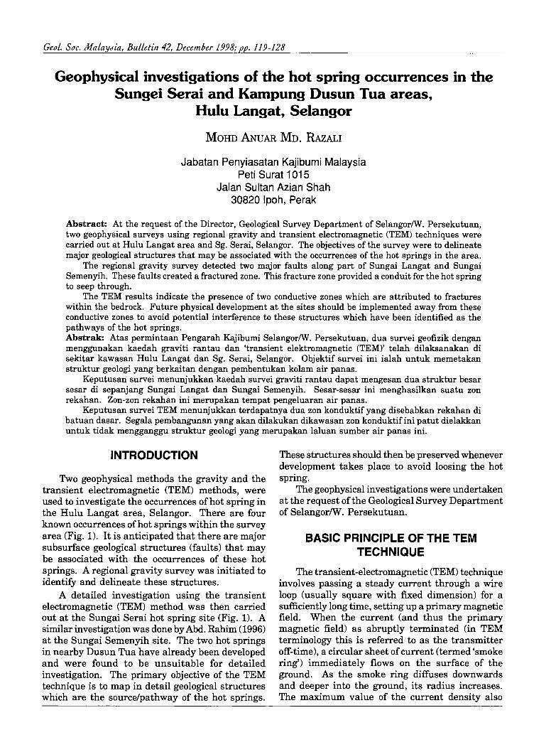
-t-Figure 1. Distribution of gravity stations and location of TEM survey site.
Ceo L. Soc. J/!/a LaYJia, BuLLetin 42

GEOPHYSICAL INVESTIGATIONS OF THE HOT SPR ING OCCURRENCES IN THE SUNGAI SERAI AND KAMPUNG DUSUN TUA AREAS 121
decreases. If conductors are present in the ground, an electromagnetic force (emf) is induced. The magnitude of this emf is proportional to the time rate-of-change of the primary magnetic field at the conductor. This emf also causes eddy currents to flow in the conductor with a characteristic decay ('transient decay') which is a function of conductivity (the inverse of resistivity), size and shape of the conductor. The decaying currents generate a proportional (secondary) magnetic field, the time rate-of-change of which is measured by a receiver coil.
TEM MEASUREMENT
The current flowing through the transmitter loop is in the form of 'pulses' (this technique is also sometimes called Pulse EM) with on and off times.
A steady current is caused to flow ('on time') in the transmitter loop for sufficiently long time before being abruptly terminated ('off time') . TEM measurements are made during the transmitter off-time, in the absence of the primary magnetic field. During the off-time, the receiver coil measures the amplitude (often referred to as voltages) of the transient decay over a series of time intervals known as delay times. In fact, the measurement of the voltages are averaged over many cycles (known as stacking) of the transmitter pulses to enhance the data. The width of these delay times (in milliseconds) is often referred to as 'windows', 'channels' or 'gates'. The delay times dictate the depth of investigation; the later the delay time, the deeper is the depth of investigation. A number of delay time series is available to cater for different depths of investigation.
422 160E 422180E 422200E 422220E 422240E 422260E 422280E 422300E LEGEND z o co N
""" r'l
!< X
L5
X
L4
L2
o 11 L9 LlO
422160E 422 180E 422200E 422220E 4222 40E 422260E 422280E 422300E
25 o (met ers)
Figure 2. Distribution ofTEM stations.
December 1998
OJ o z ../ Sg. Serai
/ Stream
D Building
[ill Hot Spring - - -- pond
"'''' Swamp ",.,v v"''''
XXxx Fence
~ Dense bushes
LZ TEM line
TEM Station
-f-

122 MOHD ANUAR MD. RAZAU
The TEM measurement can be made using either the separate loop or the coincident loop. In the separate loop configuration, two separate loops (a transmitter and a receiver loop) are required for the data acquisition. The coincident loop configuration operates with only a single loop. The loop acts as a transmitter when the current is on and as a receiver when it is off.
TEM VOLTAGES AND APPARENT RESISTIVITY
Although the TEM technique measures amplitude (voltages) of the transient decay over a number of delay times, it is possible and useful to convert the TEM voltages to apparent resistivity. This is done by applying a formula for the conversion.
When the TEM data are transformed to apparent resistivities, the subsurface can be looked at as consisting of different layers (at the point of measurement), each with a distinct resistivity. This is achieved by employing a technique known as In layered inversion (or simply 'inversion') which calculates the true resistivity, thickness and depth (from the surface) of each layer, thus producing a model of the subsurface.
FIELD PROCEDURES
The geophysical surveys were carried out from 3 to 17 July 1997, using the La Coste & Romberg Model G-972 Gravity Meter for the regional gravity survey and the Sirotem MK3 equipment for the transient electromagnetic (TEM) technique.
The regional gravity survey covered an area of 450 km2 with a total of 96 gravity stations spaced at 1 km interval (Fig. 1). As the survey area is generally inaccessible, the gravity survey was confined to locations along the roads and tracks.
For the TEM survey, readings at 128 stations, at a 10-metre station interval were taken. The stations were positioned along 14 lines, all aligned in a north-south direction (Fig. 2). The high resolution times series were used to obtain a better resolution of the shallower layers. A lO-m coincident loop configuration was utilised for the survey.
DATA REDUCTION AND PROCESSING
All gravity data were reduced to the bouguer anomaly using available software. A reduction density of 2.67 gm/cc was used for the bouguer plate correction. The reduced data were further subjected to a regional/residual separation to discriminate between localised and regional features using the second derivative filters.
The raw TEM data were automatically saved in the equipment's solid state memory during field data acquisition. For processing, the raw data were directly input into a portable computer using the PC PLUS software. The inversion of the TEM data to obtain resistivity depth profiles was done using the TEMIXP software package.
RESULTS AND DISCUSSIONS
Regional gravity survey
The bouguer anomaly map is shown in Figure 3. A gradual increase in gravity values is observed towards the southwest of the survey area. This suggests the presence of a much denser rock type in that direction. As this part of the survey area (L1) is underlain by the Kajang Formation, the higher values are attributed to the metasediments comprising of mainly schist with minor intercalations of limestone (marble) and phyllite.
To the north-east of the survey area, the Jelebu Schist (L2) is well defined by the gravity survey as it appears as gravity highs on the bouguer anomaly map. The rest of the survey area is underlain by granite which exhibits much lower gravity values as it is less dense compare to the other rock types found within the survey area.
Along Sg. Langat, the gravity contours are significantly disturbed (F1) indicating the existence of a major geological structure which is interpreted as a fault. The interpreted fault appears as a series of gravity highs and lows (F1) trending northeastsouthwest on the residual anomaly map (Fig. 4). The Semenyih Fault (F2), although not clearly observed on the bouguer anomaly map, appears as a prominent lineament trending parallel to the Sg. Langat Fault. All the known occurrences of hot spring occur along either one ofthese faults. These are strong evidences suggesting that the hot spring occurrences are fault controlled.
The residual anomaly map also indicates clearly the granite/metasediment (L1) and granite/schist (L2) contacts. The findings of the gravity survey are summarised in Figure 5.
TEM survey
The results of the survey at the Sg. Serai hot spring site are presented as apparent resistivity maps (Figs. 6 and 7) and TEM voltage profiles (Figs. 8, 9 and 10).
Apparent resistivity map
The apparent resistivity values of window 10 (delay time of 0.113 ms) and window 15 (delay time 0.341 ms) (Figs. 6 and 7 respectively) were gridded to show lateral changes of the subsurface at different
Ceol. Soc. MalaYJia, Bulletin 42

z o o o ..r I/) n
z o o a II) n
z o o o ro ..r n
z o o o II) ..r n
z o o o N ..r n
z 8 o Ol n n
z o o o <0 n n
420000£ 42.3000£ 426000£ 429000£ 4.32000£ 4.35000£
420000£ 423000£
2500
(meters)
5000 I
426000£ 429000£ 432000£ 435000£
o o o z
GJ .p. Ol o o o 2
IN ~ N o 8 z
IN '.,J <0 o o o
+ z
GJ IN o} o o o z
LEGEND
--, , ,
/ r:::l ~ + ++ +++ +++
n LJ
Rood
Track
River
Hot Spring
Fault
Semenyi fault
Quartz vein
Schist
Granite
Metasedlmen
- .,.oo~ - 14.00 --15.00 - 16 . 00 - 17 . 00 - 18 . 00 - 20,00 _ 1 <
- 22 . 00
mgals
Figure 3. Bouguer anomaly map and general geology of survey area.
420000£ 42.3000£ 426000E 429000£ 4.32000E 4.35000£ z ~-'~~--~~~~~~~~--~~~~--~~~~~~~~---'lN o (Jl o .p. o 0 ..r 0 I/) 0 n z
LEGEND
z IN ~ Road o VI o a I/) n
z o o o Cl;) ..r n
z o o o c<) ..r n
z o o o N ..r n
z o o o Ol
o o o z
IN .p. (11 o o o z
I ~ i ;1 ~ ~ I ! o 0 o 0 o 0 n - 0 '') L---1 ________ ....L ________ L-______ -L ________ L-______ -1. ______ -.l Z
420000E 423000£
2500 0 ......-.--- 2500
(meters)
5000 :
426000E 429000E 432000£ 435000E
Figure 4. Residual anomaly map (second derivative filter) .
Track
River
Hot Spring

124
z o o o "'" t1) t")
z o o o l[) t")
z o o o ,-,)
"'" n
z o o o N
"'" n
z o o o (J)
n t')
MOHD ANUAR MD. RAZALI
420000E 423000E 426000E 429000E 432000E 435000E
+ " I
,', I ,
1
+
+
+
~--' ... Kg. ~a Lebor
;. ~ __ _ ,.' f"'V
, f"'V
\~~.~UAN . ~'lAH ~ TUNTONG ~ELCRA) ,
\ rv , I
rv
+
HUTAN RIZAB SUNGAI lALANG
+ + HULU SEMENYlH
I 1 • I ,
J + , --,
420000E 423000E 426000E 429000E 432000E 435000E
2500 5000 , (meters)
Figure 5. Gravity interpretation map.
~ (Jl .j>.
LEGEND o o I~
J ~ ~ o _ o " a " z
j! Itn
1§ z
, , ,
Road
Track
River
Hot Spring
Fault
Schist
Granite
Metasediment
Ceo!. Soc. MaLaYJia, BuLLetin 42

25
~ r<)
z o N
N V r<)
Z o o N
;:!; Z o <Xl o N V r<)
Z g o N V r<)
4221 60E 4221 80E 422200E 422220E 422240E 422260E 422280E 422300E
o 25
( meters )
LEGEN D
../ / D R LJ
xXxx
Sg. Serai
Stream
Building
Hot Spring pond
Swamp
Fence
Dense bushes
-.... Conductive .... ~I Zone
20'Jo> ~ le .N 17 . 5;2 ~ 16.32
15. 1'2 ':." . 13.86 * 12 .35 1 0.~.2 .' 7. 30>
Ohm-m
Figure 6. Apparent resistivity map of Windows 10 (0.0104 ms).
5
422160E 422220E 422240E 422260E 422280E 422300E zr=~~~~~~~~~~~~~~=7~~--.------.--~--.----.u o A <Xl N
N ~ V 0 r<) Z
N v r<)
Z o N
N V r<)
Z o o N v r<)
g ~ o
~ ~ z
3 ~~. N ... : ~~~ ",~"" u
~ ~~.~~~ ~~~~ ~ r<)L-~ ______ ~ ____ ~ ______ ~ ____ ~ ____ ~~ ____ -J ______ ~ __ ~Z
422160E 422180E 422200E 422220E 422240E 422260E 422280E 422300E
o 25
(meters)
LEGEND
../ / o n u
xXxx
Sg. Serai
Stream
Building
Hot Spring pond
Swamp
Fence
Dense bushes
121' Conductive ......... .J Zone
•. 81 ~ 4.!iJ . 4 , .30 4.07
~::7 . ~ 3.J3 2.9~ .. " .' 2.41 ", .
Ohm-m
-f-Figure 7. Apparent resistivity map of Windows 15 (0.320 ms) .

126 MOHO ANUAR MD. RAZALI
1000
--Delay times (ms)
f---f---+---+- - ----i----t---i
S' 2-Ul Q) 0>
~ 0 >
100
10
0.1 342040
1000
100
0.1 342040
,..-
342060
--
.'
r-
,
342060
..--'~ / -........ ~ / -
--- -0.>. __ ~--I- k ---
- - :=== --- ---- -- "
, += 1 -+--"--1--- ":13 -t---j-- -----
+-
342080 342100 342120 342140 342160 342180
Northin m
Figure 8. TEM voltages at selected delay times for Line 5.
I LlNE-6 I
I Conductive Zone (LZ1)
-/ . '- ./ -- '\
/'" :'-..., 1 / "- ~ ./ --- ',\ '. /"
~ ~ ". i/ , ."" {' ;:..~ ~~\ --,
./< -tJ . ~ , I ---'!
---. - , .
-\ '\~ t-\ r-----" ....-
I
342080 342100 342120 342140 342160 342180 Northing (m)
Figure 9. TEM voltages at selected delay times for Line 6.
. 0.C66
* 0 .080
0.128
,~ 0.224
0.320
. 0.464
* 0.656
.. 0.848
1.232
Delay times (ms)
• D.CE6
.. O.Cl!O
~ 0.128
v 0.224
0.320
. 0.464
* 0.656
.. 0 .848
1.232
Geo L. Soc. M alaYJia, BuLLetin 4]

>' 2-III QI Ol
4l! 0 >
5
1000 .ond ." ===±:- ,
hot spring pond (P2) X-- :-r- - ---. - - ~n- f-:- r- --I-
/' I--'--- -100 - - - .....::s~ = .-=
,.- ~, .L/t -~ ,,~ ~r~' - ~~ -- . ~ ..... k--. A., -L V l
~ ::::::-< ~~- --~ ~~~ ~ ~ .
, .il·· .....-: "c-_
'---T-~ "-<"- -- ~ ~ '~' 10
.,. ....... J-- -......., /'
~ .. ~~~ /' / I
I L l-·
0.1 342040
- • . -" ~ . , ----..... ... -
I
342060 342080
.-t
.!,
' . • -
-- , 1---'--1 , :
342100 342120 342140 342160 Northing (m)
Figure 10. TEM voltages at selected delay times for Line 7.
422160E 422180E 422200E 422220E 422240E 422260E 422280E 422300E z / (.,J
0 I j,/xx -l>-
0Cl N
N I x x co .q-
I // 0
I") z
z I '/fx
(.,J
0 t)x -l>-lD
11~/ N
N Ol .q- 0 I") Iii /x x
z Z 0J "x X .j>. 0
11/ _ .q- ,~
N .j>. .q-
() 0
I") 1 x z z x (.,J
0 .j>.
N N ~
N N .q- 0 I") z z "'. (.,J
0 bO -l>-0 N
" N '" 0 .q- '" .. 0 I") ... z z ~ " '"
(.,J
0 " .j>.
co '"
N 0 '"
0 N
~ co
.q- " 0 I")
" 0 z
Z IJ1 (.,J
" 0
~~ '" -l>-
lD N 0 'Y 0 N '"
Ol <t " Ii' 0 I")
~~ ~ z
'" '" ,... z " 0 (.,J
0 \V W ~ .j>. .q- -~~~~~
N 0
~~~ 0
N .j>. .q- 0 I") z
422160E 422180E 422200E 422220E 422240E 422260E 422280E 422300E
0 25
(meters)
Figure 11. TEM interpretaiton map.
Delay times (ms)
342180
. 0.032
• O.ca;
* 0 .(8)
0.128
. 0.464
*' 0.£56
. Q84B
• 1232
LEGEND
./ Sg. 5erai
/ Stream
D Building
[ill] Hot Spring pond - - .. -
... .., Swamp ""'''' v""
xxxx Fence
~ Dense bushes
S Proposed Borehole
Conductive Zone
-f-

128 MOHD ANUAR MD. RAZAu
'levels' of depth. The later window (window 15) is 'seeing' at a relatively greater depth.
Both the apparent resistivity maps (Figs. 6 and 7) show almost similar features. Two conductive zones (LZI and LZ2) are observed on both the maps. The two existing hot spring ponds are located on LZI. These conductive zones are due to fractures within the rock which acts as conduits for the hot spring water to ascent to the surface. Fractures in the rocks will render the zone conductive as it allows water to flow through. The presence of the fractures is further substantiated by the existence of a major fault delineated by the gravity survey. Development of the fault would have induced fractures to occur in the rock.
The third conductive zone (LZ3) observed on the maps is not real and should be ignored. This is due to the presence of water pipes and zincs close to the surface which affected the TEM measurements.
TEM voltage profile Figures 8, 9 and 10 show the TEM voltages at
selected delay times for lines 5, 6 and 7 respectively. The liens crosses the conductive zone, LZI. The profiles indicate changes in conductivity, both laterally and vertically. The delay times were chosen to reflect different 'levels' of depth penetration. The later delay times indicate a greater depth of penetration.
The conductive zone appears as high voltages between stations 342100N to 342140N (Fig. 8), 342090N to 342140N (Fig. 9) and 342080N to 342130N (Fig. 10). In Line 5 (Fig. 8) the hot spring pond (PI) occurs between 342116N to 342135N. The second hot spring pond (P2) appears between 342100N to 342110N in Line 7 (Fig. 10). All the hot
spring ponds are located in conductive zone LZl. This indicates that the occurrences of the hot spring are associated with the fractures which allows the hot spring water to flow through to the surface.
CONCLUSIONS AND RECOMMENDATIONS
The regional gravity survey delineated two major faults, Fl and F2 along Sungai Langat and Sungai Semenyih respectively. All the hot spring occurrences are located along these two faults. This strongly suggests that the occurrences of the hot springs are directly associated with the fault which induced the development of fracture zones which provides a conduit for the hot spring to seep through and ascent to the surface.
The TEM survey at Sungai Serai hot spring site delineated two conductive zones which are attributed to fractures in the rock. These fractures have been identified as the main pathways of the hot springs. It is recommended that future development and construction on this site should be kept away from the known conductive zones so as to preserve these subsurface geological structures and to avoid any potential impacts to the hot spring flow.
Boreholes are recommended to be drilled at locations as shown in Figure 11 to confirm the geophysical findings.
REFERENCE
ABDUL RAHIM, H., 1996. Hot Spring Investigation Using Transient Electromagnetic Technique in Sg. Lalang,Hulu Langat, Selangor. Report GF 06/96 (Unpubl.), /abatat! Penyiasatan Kajibumi Malaysia.
...... Mllnuscript received 2 November 1997
Geot. Soc. MataYJia, Bulletin 42


