Embed Size (px)
Citation preview

Italian Journal of Engineering Geology and Environment - Book Series (6) www.ijege.uniroma1.it © 2013 Sapienza Università Editrice
481
DOI: 10.4408/IJEGE.2013-06.B-46
GEOMATICS FOR SLOPE STABILITY AND ROCK FALL RUNOUT ANALYSIS: A CASE STUDY ALONG THE ALTA TAMBURA ROAD
IN THE APUAN ALPS (TUSCANY, ITALY)
RiccaRdo SALVINI & MiRko FRANCIONI
University of Siena - Department of Environment, Earth and Physical Sciences and Centre of Geotechnologies - Siena, Italy
Key words: rock topple, runout, photogrammetry, laser scan-ning, GIS
INTRODUCTIONThe present research started in 2007 when, after a
rock fall event occurred during the night of February 27-28 in the Guadine village area (Fig. 1), the Massa Municipality decided to conduct a detailed study on the stability of the slope overhanging the Alta Tambura road. The road connects Massa to five villages of the Apuan Alps - Guadine, Gronda, Redicesi, Casania and Resceto, which were isolated for several days because of the main street destruction due to the event. The presence of large angular boulders at the bottom of the valley implies that this area has already experienced
ABSTRACT With increasing awareness of geological risks, the
study of rocky slopes plays a key role in the Earth Sci-ences, especially in areas of high vulnerability due to the presence of human settlement. The present paper de-scribes the stability and runout analyses carried out along the Alta Tambura road, in correspondence with the Gua-dine village connecting the Massa urban settlement to the Apuan Alps (Tuscany, Italy). The integration among various types of survey and analytical methodologies al-lowed for the application of up-to-date approaches for hazard assessment. Results from these types of studies are useful in the decision-making process concerning choosing the most appropriate mitigation works and, as in such a case, their a posteriori validation. With regard to the survey techniques, terrestrial laser scanning and digital close-range photogrammetry were used to pro-duce the digital elevation model, oriented stereo-images, orthophotos and accurate positions and volumes of rocky wedges and joints located on the slope overhanging the analyzed road. Thanks to this data, a deterministic sta-bility analysis was conducted and the spatial distribution of rock fall density, velocities and kinetic energies was modeled by means of the “cone-method”. Historical evi-dence of rock falls, identified during fieldwork activities and photointerpretation, were used to assess and cali-brate the accuracy of results obtained from the method and allowed, through a further 2D rock fall runout analy-sis, the calculation of the dissipation energy that protec-tion measures need to mitigate the risk in the area.
Fig. 1 - Orthophoto of the Guadine village showing the zone affected by rock fall in 2007, and highlight-ing Alta Tambura road on March 7, 2007; inset map of Tuscany showing the Apuan Alps in red

R. SALVIN1 & M. FRANCIONI
482
International Conference Vajont 1963-2013. Thoughts and analyses after 50 years since the catastrophic landslide Padua, Italy - 8-10 October 2013
alii, 2005) we assessed the probabilistic distribution of rock fall end points, velocity and kinetic energy along the rock falling paths and existing barriers. By model-ling the spatial distribution of rock fall frequency, we improved the accuracy of the study moving from a 2D analysis, which assumes that the fall follows the path of steepest descent, to a 2.5D approach.
GEOLOGICAL AND GEOMORPHOLOGI-CAL SETTING
In the rock fall area and at the base of the Renara stream, outcrops are composed of lithotypes belonging to the Paleozoic Crystalline Basement of the Apuan “Autochthonous” (caRMignani, 1985) which consists of the “Porphyroids and porphiric schists” and the “Lower Phyllites” formations. Porfiroids are made of rhyolitic-rhyodacitic metavulcanites, are either light green or gray in colour, with millimeter crystals of quartz and feldspars in a quartzitic, muscovitic and chloritic matrix. Porphiric schists are characterized by muscovitic-chloritic fillads and metarkoses with abundant quartzitic porphyroclasts., The “Grezzoni” formation crops out on the slope, above the crystal-line basement. Thin and discontinuous lenses of “Ser-avezza Breccias” and “Megalodon marble” separate this formation from the overlying “Dolomitic marble”, which is made of light gray-pinky dolomite alternat-ing with dolomitic marble. Such a geological sequence belongs to the “Autochthonous” Unit and crops out in the overturned limb of the “Vinca-Forno” anticline, a non-cylindrical isoclinal NE-vergent fold, formed dur-ing the first compressive deformation event (D1 phase) and dated as late Oligocene - very early Miocene (caRMignani & kligfield, 1990). Since the early Mi-ocene, a second deformation phase (D2) overprinted the earlier structures, generating new ductile to ductile-brittle (and later only brittle) structures linked to post-compression tectonic uplift and internal extension of the piled-up tectonic units. In the study area, the folds generated during the D2 phase show axes oriented at N300° and dips gently towards the NE
With regard to the geomorphology, the study area is strongly influenced by the structural-geological ar-rangement of the Apuan Alps. The area belongs to the M. Cipolla - M. Girello ridge characterized by a SW-NE direction and by a very sharp crest, which varies in elevation between 630 and 930 m a.s.l.. The upper part of the ridge is composed of carbonaceous rocks
rock falls, leading to serious problems for the road.The aim of this study is to acquire detailed geo-
logical and topographical information which, together with climate and chemical weathering, induce rock fracturing, opening of joints, rainfall infiltration, and subsequent instability (liM et alii, 2004). Once the failure process initiates, the rock detaches and the fall-ing trajectory is dictated by slope geometry and land use. The lack of detailed data on slope topography, in-stability source areas, rock block geometry and falling paths, including runout distance, can limit the assess-ment of rock fall hazard (doRRen, 2003, glenn et alii, 2006). In order to obtain all the information necessary to perform the slope stability analysis and the rock fall runout simulation, several types of geomatic surveys and analytical methodologies were proposed. In this paper, we used Digital Terrestrial Photogrammetry (DTP) and Terrestrial Laser Scanning (TLS) to study the geometric characteristics of slopes, rocky wedges and discontinuities, thus overcoming problems like the inaccessibility of outcrops and the complexity of the slope morphology. Today, TLS is one of the best ways to characterize the rock mass (fekete et alii, 2010; taMbuRi, 2008; nguyen et alii, 2011; Runqiu & Xiujun, 2008), to analyze the slope stability (aRM-esto et alii., 2009; nagalli et alii, 2012; kaspeR-ski et alii, 2010), and to model the rock fall (abel-lán et alii, 2010; OppikofeR et alii, 2009; Monnet et alii, 2010). DTP also provides information about the structural and geo-engineering setting of slopes. Since the 1970s, photogrammetry has been utilized to characterize the rocky mass (Wickens & baRton, 1971; Mosaad allaM, 1978) and nowadays, thanks to the advance of digital and informatic methodolo-gies, it has became widespread either with (feRReRo et alii, 2009; stuRzeneggeR & stead, 2009; Salvini et alii, 2011; salvini et alii, 2013) or without TLS (HanebeRg, 2008; Roncella et alii, 2005; StuRzeneg-ger et alii, 2009; fiRpo et alii, 2011).
The geomatics technologies used can yield ori-ented stereo-images, orthophotos and precise digital models of slopes and rocky wedges. Geometrical and structural characteristics of slopes, such as joint atti-tude, spacing and persistence, and block volumes, can be also derived. The results were used together with a deterministic method to evaluate the slope stability. Through the application of the “cone-method” (toppe, 1987; jaboyedoff & labiouse, 2003, jaboyedoff et
GEOMATICS FOR SLOPE STABILITY AND ROCK FALL RUNOUT ANALYSIS:A CASE STUDY ALONG THE ALTA TAMBURA ROAD IN THE APUAN ALPS (TUSCANY, ITALY)
Italian Journal of Engineering Geology and Environment - Book Series (6) www.ijege.uniroma1.it © 2013 Sapienza Università Editrice
483
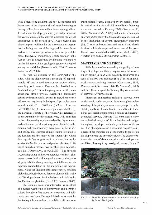
trated rainfall events, alternated by dry periods. Stud-ies carried out for the rock fall immediately following the event occurred on February 27-28 (salvini et alii, 2007a; salvini et alii, 2007b) and additional in-depth analyses performed by the Massa Municipality resulted in the installation of several protectionary measures (Fig. 2) such as beams, bars and inelastic and elastic barriers both in the upper and lower part of the slope. Elastic barriers, installed in 2010, are certified (E2000), 4 meters high and able to support up to 2,000 kJ
MATERIALS AND METHODSWith the aim of understanding the geological set-
ting of the slope and the consequent rock fall causes, a new geological map with instability landforms at a scale of 1:5,000 was produced (Fig. 3) based on field-work surveys, existing literature (caRMignani, 1985; caRMignani & kligfield, 1990; di pisa et alii, 1985) and the official map of the Tuscany Region at a scale of 1:10,000 (249110 section).
Moreover, engineering-geological surveys were carried out in such a way as to have a complete under-standing of the joint systems necessary to perform the stability analysis of latent blocks. In addition to tradi-tional geological, geomorphological and engineering–geological surveys, DTP and TLS were used to carry out a detailed analysis of discontinuities and wedges throughout the slope, particularly in inaccessible ar-eas. The photogrammetric survey was executed using a reamed bar mounted on a topographic tripod set on the slope facing the one under study. The distance be-tween the zone of data acquisition and the slope was ca. 300 m, thus requiring two digital cameras, CanonTM
with a high slope gradient, and the intermediate and lower parts of the slope consist of rocks belonging to the crystalline basement with a lower slope gradient. In addition to the slope gradient, type and presence of the vegetation also influences the structural-geological arrangement of the area; in fact, it was observed that slopes appear rockier with the discontinuous vegeta-tion in the highest part of the ridge, while dense forest and soil cover is more prevalent in the lower part of the slope. This type of morphology is quite common in the Apuan Alps, as documented by literature with studies on the influence of the geological-geomorphological setting on landslides (baRoni et alii, 2010; d’aMato avanzi et alii, 2000).
The rock fall occurred on the lower part of the ridge, with the slope having a mean dip of approxi-mately 38° and a rectilinear-convex profile, which, according to leHMan (1756), can be classified as a “rectified slope”. The outcropping rocks in this area experience strong physical weathering dominantly caused by intense rainfall events. In fact, the meteoric affluxes are very heavy in the Apuan Alps, with a mean annual rainfall of over 3,000 mm (d’aMato avanzi et alii, 2004). This pluvio-metric regime is controlled by the particular climate of the Apuan Alps, referred to as the Apennine–Mediterranean type, with transition to the sub-coastal type, characterized by dry summers and cold winters, with a primary peak of rainfall in the autumn and two secondary maximums in the winter and spring. This extreme climate feature is related to the location and the shape of the Apuan Alps, which intercept air flow originating from the Atlantic to the west or the Mediterranean, and produce the forced lift-ing of humid air masses, favoring their rapid adiabatic cooling (d’aMato avanzi et alii, 2004). The physical weathering acting in the area, together with karst phe-nomena associated with the geology, are conducive to slope instability, thus generating rock falls and debris deposits accumulation in the morphological depres-sions. Along the SE slope of the ridge, several nivation niches host debris deposits that occasionally fail, while the NW slope shows nivation hollows referable to the last Pleistocene glaciation (bini, 2005; fedeRici, 2005).
The Guadine event was interpreted as an effect of physical weathering of porphyroids and porphiric schists through surface processes, generating rock falls on the steepest slopes. The rock debris deposits are at the limit of equilibrium and can be mobilized after concen-
Fig. 2 - Examples of protectionary measures executed by the Massa Municipality

R. SALVIN1 & M. FRANCIONI
484
International Conference Vajont 1963-2013. Thoughts and analyses after 50 years since the catastrophic landslide Padua, Italy - 8-10 October 2013
tion and two LeicaTM System 1200 GPS receivers were used for the topographic survey (Fig. 4A). Through the GSM connection to the Leica GeosystemsTM Spider-Net network, differential GPS techniques were applied with the aim of determining the absolute coordinates of the system origin, and that of the azimuth zero direc-tion. By this technique, since the total station allowed for determination of the relative coordinates of sur-veyed points (X, Y and Z) through the measurement of angles and distances and trigonometric calculations, absolute coordinates of ca. 100 GCP were calculated and used for the absolute orientation of the images within LPS module of ERDASTM IMAGINE software.
Moreover, a RiegelTM Z420i TLS (Fig. 4B) was used to acquire a point cloud necessary for the 3D modelling of the slope. The distance between the slope and the instrument ranged from 250 to 400 m and the spatial resolution of the point cloud was set to 7 cm at a distance of 300 m, corresponding to a scanning angle of 0.013°. The point cloud was stored and processed using LeicaTM Cyclone software. The described topo-graphic survey was also utilized for the registration to absolute coordinates of the TLS point cloud.
Data was analyzed by DTP and 3D modelling techniques that, managed within a Geographical In-formation System (GIS), constructed a complete deterministic understanding of the geometric charac-
Eos5D and Eos20D, with focal lengths varying from 10 to 200 mm to produce detailed and panoramic pho-tos. The resolution of the two cameras was set to 14 and 8 Megapixel, respectively. The direction of strips was oriented parallel to the slope as much as possible, at N65, with pitching at approximately ±15° from the horizontal in order to have a complete photographic coverage of the unstable slope.
Differential GPS and topographic surveys were also carried out in order to collect Ground Control Points (GCP), that were clearly visible on the slope and necessary for the absolute orientation of the images. A LeicaTM TCRP 1203+R1000 (reflectorless) total sta-
Fig. 4 - Topographic surveying with the total station (A); TLS during data acquisition (B)
Fig. 3 - Geological map showing instability landforms and a cross section; (black-colored fold axes represent minor struc-tures of D1 phase within the “Vinca-Forno” anticline; blue-colored structures relate to antiform and synform axes of the D2 phase refolding of the primary schistosity)

GEOMATICS FOR SLOPE STABILITY AND ROCK FALL RUNOUT ANALYSIS:A CASE STUDY ALONG THE ALTA TAMBURA ROAD IN THE APUAN ALPS (TUSCANY, ITALY)
Italian Journal of Engineering Geology and Environment - Book Series (6) www.ijege.uniroma1.it © 2013 Sapienza Università Editrice
485
0.049 for the horizontal and vertical acceleration, re-spectively. The percentage of water saturation in joints was empirically varied from 0 to 100%. The procedure was carried out in accordance to the Italian Norme Tec-niche per le Costruzioni (NTC) (M.LL.PP., 2008). In addition to the deterministic study, a probabilistic and sensitivity analysis on Safety Factor (SF) related to the critical joint system was performed with the aim of de-fining its variation as combination of input variables, as shown in Tab. 1.
Taking into account the presence of the road and the houses at the bottom of the slope, results of the sta-bility study were integrated with a detailed rock fall ru-nout analysis based on the DEM. The analysis was con-ducted by means of RocFall software (RocscienceTM).
The “cone-method” was applied through the free-ware Conefall software (QuanterraTM) in order to cal-culate the spatial distribution of rock fall transit den-sity, velocities and kinetic energy. This required the usage of the DEM and the source position of the most dangerous blocks sited on the slope, which were iden-tified through the photointerpretation of terrestrial pho-tos. Results were used to validate the dispersion areas and to create proper rock fall trajectories. This method maps the general rock fall spatial distribution and is helpful in understanding which areas could be affected by a hypothetic rock fall. However, values obtained from these simulated rock fall events were calculated based on all the blocks sited on the slope in this study, so the real velocity and kinetic energy which could be reached during a fall could not be determined for each individual block. Hence, with the aim of trying to overcome such a limitation, the method was calibrated by calculating the volume of rocky blocks present at the bottom of the valley, which are remnants of past failures from the slope. This was conducted using fieldwork data and evidence from photointerpretation. This, in combination with a further 2D rock fall simu-lation, allowed us to better assess the kinetic energy of blocks during the fall and, consequently, the dissipa-tion energy that protection measures should have in or-der to effectively mitigate the risk of similar collapses.
RESULTSThe cognitive survey shows that the 2007 rock
fall originated from an elevation of 316 m a.s.l., forming a detachment niche 18 m wide. The rock fall reached the Renara stream bed at an elevation of 180
teristics of slopes, wedges and joints. These, together with engineering-geological fieldwork measurements, allowed for the analysis of the stability of the slope and the rock fall runout.
Kinematic analyses of stability were carried out using joint systems so that latent phenomena could be geometrically identified. Dips. 6.0 software (Roc-scienceTM) was used for this deterministic study, using friction angles from the engineering-geological survey and several slope attitudes as computed from spatial processing of the Digital Elevation Model (DEM). The DEM was created from TLS data which was merged to morphological features, which were stereo-restituted from terrestrial and aerial photographs, and altogether were merged to the existing topographic maps at a scale of 1:2,000; this activity was necessary to fill shad-ows that resulted in the point cloud in proximity to veg-etated areas and at the toe of the slope near the stream bed. The final DEM was created in grid format with a 1 m cell size. Spatial analysis techniques were applied to the DEM in order to obtain the slope and the aspect of different slope zones, giving the dip and dip direction to be utilized in the stability analysis. Spatial variability of the slope morphology was then used for the purpose of studying the steadiness of several dipping slopes, up to the computed maximum stable slope angles.
Results from the kinematic stability analysis high-lighted a critical joint system conducive to toppling. Hence, we performed a dynamic study using the beta testing version of the RocTopple software (Rocscien-ceTM), which is based on the goodMan & bRay method (1976). The study was carried out under both static and dynamic conditions, dependant on the local seismic ac-celeration and the percentage of water saturation. We derived seismic coefficients (dimensionless numbers that define the seismic acceleration as a fraction of the acceleration due to gravity) from the GeoStru PS soft-ware (geostRu, 2008), obtaining values of 0.099 and
Tab. 1 - Variables and relative ranges used in the probabi-listic study on SF

R. SALVIN1 & M. FRANCIONI
486
International Conference Vajont 1963-2013. Thoughts and analyses after 50 years since the catastrophic landslide Padua, Italy - 8-10 October 2013
m a.s.l., overtopping a 90 m long stretch of the Alta Tambura road.
The study revealed that the landslide originated as a rock topple involving boulders and soil in prox-imity to an hold trail which was characterized, in that part, by a dry stone wall. Rainfall events in the days preceding the landslide led to initial failure triggered by poor drainage and an increase of water pressure at the interface between debris and rocky basement. Toppling of rock down the steep slope by bouncing, rolling and sliding then increased the volume of the failed mass, clearing the slope of soil, debris and stones in unstable equilibrium and destroying the old anthropic terraces which characterized the slope from 250 to 185 m a.s.l.. The mechanism which caused such an event represents one of the most
critical geomorphologic vulnerabilities of the zone, prone to rock toppling and to the difficulties of con-trolling the water runoff.
The integration of geomatics and traditional en-gineering-geological surveys allowed for the deter-mination of the attitude of joint systems and slopes. Measurements from DTP were compared with field-work data by means of a density analysis of attitudes in stereographic projection (Fig. 5). As shown in the figure, similarities between the joint distribution ob-tained through engineering-geological surveys and DTP are evident, even if the photogrammetric data have a greater dispersion. This is because the engi-neering-geological survey was carried out in acces-sible outcrops, whereas DTP photointerpreted joints refer to the whole 3 ha wide slope. The larger the area under study, the more the attitude of joints may vary. Nevertheless, the mean attitude derived from the two methods corresponds well with data variability that is always less than 10° (Tab. 2).
Tab. 2 - Mean values of joint systems attitude from geo-engineering survey and DTP
Fig. 5 - Contour plots of joint systems from engineering-geological survey and DTP. Data is presented using stereographic projection through the Schmidt equal-area method
Tab. 3 - Variation of SF in different slopes taking into ac-count water saturation in joints and local seismic acceleration (sc=seismic coefficients)

GEOMATICS FOR SLOPE STABILITY AND ROCK FALL RUNOUT ANALYSIS:A CASE STUDY ALONG THE ALTA TAMBURA ROAD IN THE APUAN ALPS (TUSCANY, ITALY)
Italian Journal of Engineering Geology and Environment - Book Series (6) www.ijege.uniroma1.it © 2013 Sapienza Università Editrice
487
points for failures and for the measurement of the volume of the most dangerous blocks located on the slope, yielding sizes ranging from 7 to 500 m3 and a mean value of 90 m3. This was followed by a dynamic stability analysis of the F2 system, which included the computation of the slope stability limit angles. In addition to the geometrical characteristics of slopes and joints, RocTopple also requires input data such as the rock unit weight (2.7 t/m3), the shear strength model (Mohr-Coulomb), the joints friction angle (30°) and the cohesion (0.04 t/m2). The values used for this computation came from the engineer-ing-geological survey, rock mass classification and literature. Table 3 shows the variation of SF for dif-ferent slopes up to the slope stability limit angles, taking into account water saturation in joints and lo-cal seismic acceleration. It shows that SF is always greater than the physical limit (1.00) with the excep-tion of slope stability limit angles which lie close to or below 1.00, both in static and dynamic conditions. The change of slope dip direction and the relative F2 apparent dip reduction cause the decrease of SF.
Based on slope morphology as measured from the DEM, the kinematic stability analysis was conducted by testing several slopes with dip directions and dips varying respectively from 115 to 160° and from 40 to 60°. The F2 joint system proved positive to toppling failures and the subsequent kinematic analysis, aimed to calculate the slope stability limit angles, gave the following results: if considering 30° of dip direction variability plus a tolerance of 10° because of system scattering, unstable slopes may vary from 125 to 205° in dip direction with a dip of about 13°. When dealing with toppling kinematic analyses, the friction angle (30° for the F2 system) must also be considered to compute the slope limit angle, so that it may finally vary from 125/43 to 205/43.
By means of spatial analysis techniques, these values of dip direction and dip were applied within ArcGIS software (ESRITM) to map the combination between “aspect” and “slope” calculated from the DEM; this processing made it possible to highlight areas potentially prone to this kind of collapse (Fig. 6)
DTP allowed for the identification of the source
Fig. 6 - Map of source points and areas where the slope attitude values are out of the stability range for F2 joint system toppling (A). Stereographic projection of maximum stable slope angles using the Wulff equal-angle method (B)
R. SALVIN1 & M. FRANCIONI
488
International Conference Vajont 1963-2013. Thoughts and analyses after 50 years since the catastrophic landslide Padua, Italy - 8-10 October 2013
the method in terms of rock fall velocity and kinetic energy, all the achieved results were then confirmed through comparison with evidence of rocky blocks collapsed in the past from the slope and recognizable today on the stream bed.
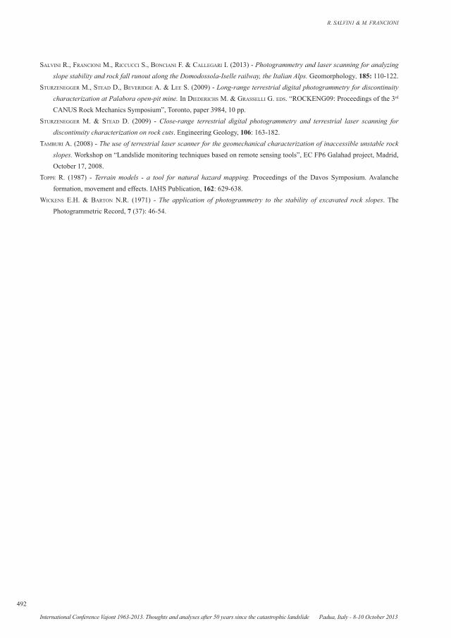
Thus, considering the position and the typology of the barriers installed on and at the foot of the slope, a further 2D runout analysis was carried out with the aim of evaluating the kinetic energy that every sin-gle block could potentially have upon impact with the protectionary structures. Fig. 9 shows an example of such an analysis where a block, during ten trials, is successfully stopped by the barriers. Knowing this deterministic energy, it was possible to verify the ef-ficiency of the installed protectionary measures in any different studied zones. Results of this study showed very high values of kinetic energy when simulating the detachment of big blocks located at the top of the slope. The value of impacting energy decreased for smaller blocks or those sited in the lower part of the slope. It is important to underline that the Massa Municipality installed protection barriers which are either double or triple-lined. Therefore, acting togeth-er, these barriers could limit even very high rock fall energy (Fig. 9). Considering that the value of kinetic energy was sometimes much larger than one toler-able by the most efficient existing passive protection systems, additional active reinforcements have been adopted and partially completed. This has been pos-sible through the installation of steel cable panels, the attachment of blocks to stable portions of the slope
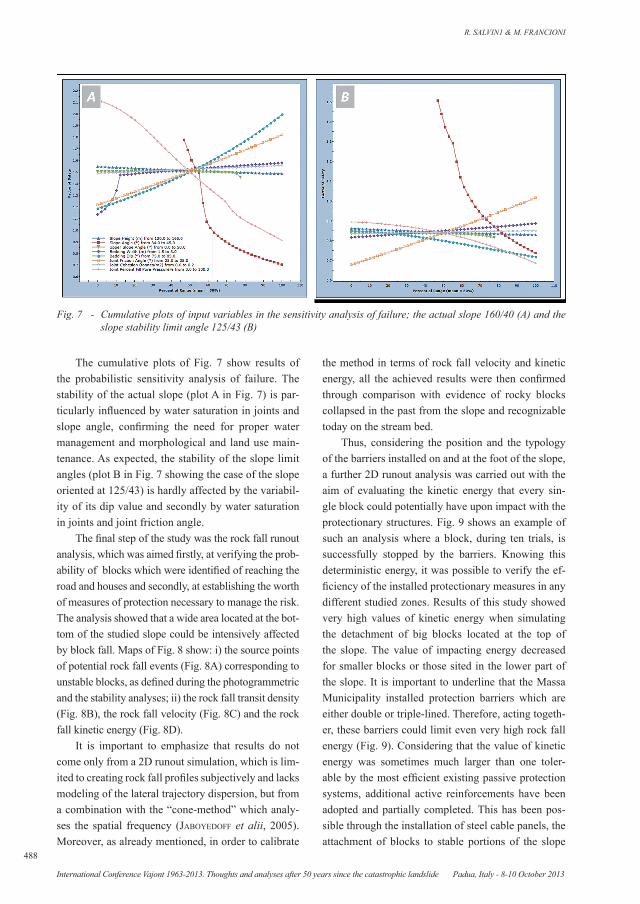
The cumulative plots of Fig. 7 show results of the probabilistic sensitivity analysis of failure. The stability of the actual slope (plot A in Fig. 7) is par-ticularly influenced by water saturation in joints and slope angle, confirming the need for proper water management and morphological and land use main-tenance. As expected, the stability of the slope limit angles (plot B in Fig. 7 showing the case of the slope oriented at 125/43) is hardly affected by the variabil-ity of its dip value and secondly by water saturation in joints and joint friction angle.
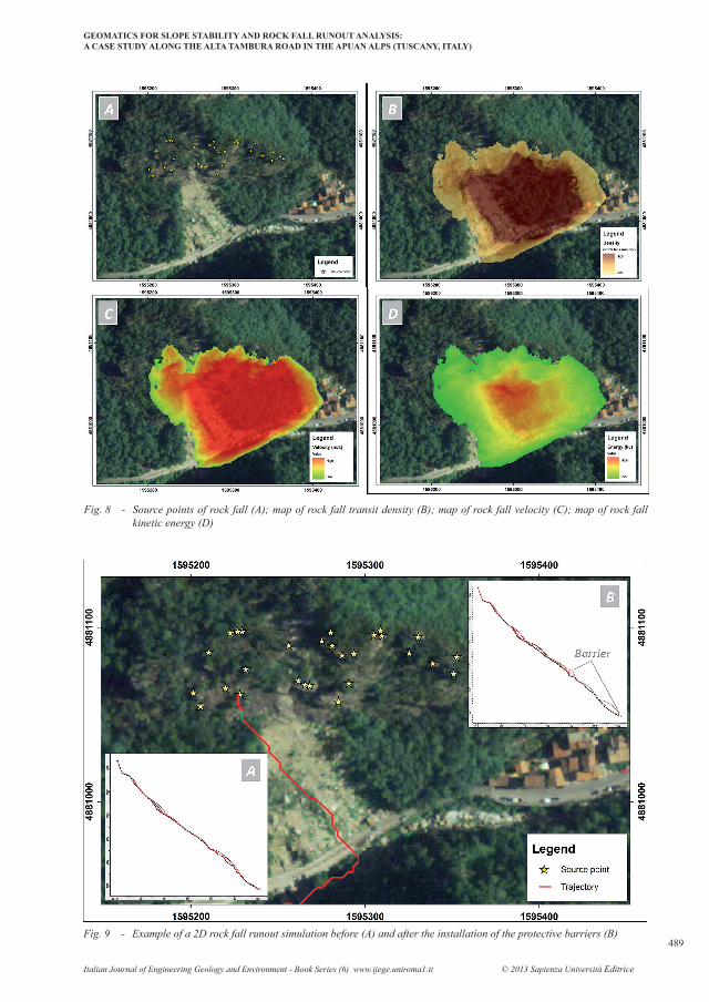
The final step of the study was the rock fall runout analysis, which was aimed firstly, at verifying the prob-ability of blocks which were identified of reaching the road and houses and secondly, at establishing the worth of measures of protection necessary to manage the risk. The analysis showed that a wide area located at the bot-tom of the studied slope could be intensively affected by block fall. Maps of Fig. 8 show: i) the source points of potential rock fall events (Fig. 8A) corresponding to unstable blocks, as defined during the photogrammetric and the stability analyses; ii) the rock fall transit density (Fig. 8B), the rock fall velocity (Fig. 8C) and the rock fall kinetic energy (Fig. 8D).
It is important to emphasize that results do not come only from a 2D runout simulation, which is lim-ited to creating rock fall profiles subjectively and lacks modeling of the lateral trajectory dispersion, but from a combination with the “cone-method” which analy-ses the spatial frequency (jaboyedoff et alii, 2005). Moreover, as already mentioned, in order to calibrate
Fig. 7 - Cumulative plots of input variables in the sensitivity analysis of failure; the actual slope 160/40 (A) and the slope stability limit angle 125/43 (B)
GEOMATICS FOR SLOPE STABILITY AND ROCK FALL RUNOUT ANALYSIS:A CASE STUDY ALONG THE ALTA TAMBURA ROAD IN THE APUAN ALPS (TUSCANY, ITALY)
Italian Journal of Engineering Geology and Environment - Book Series (6) www.ijege.uniroma1.it © 2013 Sapienza Università Editrice
489
Fig. 8 - Source points of rock fall (A); map of rock fall transit density (B); map of rock fall velocity (C); map of rock fall kinetic energy (D)
Fig. 9 - Example of a 2D rock fall runout simulation before (A) and after the installation of the protective barriers (B)

R. SALVIN1 & M. FRANCIONI
490
International Conference Vajont 1963-2013. Thoughts and analyses after 50 years since the catastrophic landslide Padua, Italy - 8-10 October 2013
through bars, bolts and steel cables and slings, and the creation of more efficient draining systems necessary to avoid water overpressures.
CONCLUSIONSGeological and engineering-geological studies, in-
tegrated with geomatics surveys, highlight the intercon-nection between geological setting, geomorphology, meteorological events, climate and slope instability. Under particular climatic conditions and land conser-vation abandonment, rock blocks and debris deposits could trigger unexpected failures which are then able to evolve into large landslides, as in this case study.
Moreover, this study demonstrated that by inter-acting with other systems and the slope, the F2 joint system could generate rock blocks prone to toppling, as proven by the presence of large angular boulders at the bottom of the valley.
The attitude of other joint systems, variously dip-ping towards the slope (i.e. F1, K2), favors water in-filtration and, without the creation of more efficient drainage networks, could induce new instability events.
The estimation of the area affected by rock fall was produced through the analysis of the transit den-sity spatial distribution. Based on these results, the subsequent 2D runout analysis enabled calculation of the proper trajectories and determination of the en-ergy that blocks could reach during hypothetical slope rockfall. Knowing the kinetic energy of blocks made it possible to evaluate and assess the efficiency of pro-tectionary systems which have been installed.
ACKNOWLEDGMENTSThe authors wish to acknowledge the support by
Massa Municipality, geol. Andrea Piccinini and Roc-science Inc.
REFERENCESabellan a., calvet j., vilaplana j.M. & blancHaRd j. (2010) - Detection and spatial prediction of rockfalls by means of
terrestrial laser scanner monitoring. Geomorphology, 119: 162-171.aRMesto j., oRdonez c., alejano l. & aRias p. (2009) - Terrestrial laser scanning used to determine the geometry of a granite
boulder for stability analysis purposes. Geomorphology, 106: 271-277.baRoni c., Ribolini a., bRuscHi g. & Mannucci p. (2010) - Geomorphological map and raised-relief model of the Carrara
marble Basins, Tuscany, Italy. Geogr. Fis. Dinam. Quat., 33: 233-243.bini M. (2005) - Glacial landforms in the Apuan Alps (Tuscany -Italy): features in danger of extinction. Il Quaternario, Italian
Journal of Quaternary Sciences, 18 (1): 175-178.caRMignani L. & kligfield R. (1990) - Crustal extension in the Northern Apennines: the transition from compression to
extension in the Alpi Apuane core complex. Tectonics, 9: 1275-1303.caRMignani L. (1985) - Carta geologico-strutturale del complesso metamorfico delle Alpi Apuane (Foglio Nord) - Scala
1:25.000. LAC - Litografia Artistica Cartografica, Florence, Italy.d'aMato avanzi g., gianneccHini g. & puccinelli R. (2000) - Geologic and geomorphic factors of the landslides triggered
in the Cardoso T. Basin (Tuscany, Italy) by the June 19, 1996 intense rainstorm. Proc. of 8th International Symposium on Landslides: 381-386.
d'aMato avanzi g., gianneccHini g. & puccinelli R. (2004) - The influence of the geological and geomorphological settings on shallow landslides. An example in a temperate climate environment: the June 19, 1996 event in northwestern Tuscany (Italy). Engineering Geology, 73: 215-228.
di pisa a., gattiglio M., MeccHeRi M. & vietti n. (1985) - Nuovi dati sulle Metabasiti della Valle del Giardino del Basamento Paleozoico Aprano. Atti Soc. Tosc. Sc. Nat. Ser.A, 95: 89-103.
doRRen L.K.A. (2003) - A review of rock fall mechanics and modelling approaches. Progress in Physical Geography, 27: 69-87.fedeRici P.R. (2005) - Aspetti e problemi della glaciazione Pleistocenica nelle Alpi Apuane. Istituto Italiano di Speleologia.
Memorie, Ser.II, 18: 19-32.fekete s., diedeRicHs M. & lato M. (2010) - Geotechnical and operational applications for 3-dimen. laser scanning in drill and
blast tunnels. Tunnelling and Underground Space Technology, 25: 614-628.feRReRo a.M., foRlani g., Rondella R. & voyat H.i. (2009) - Advanced geostructural survey methods applied to rock mass
characterization. Rock Mechanics and Rock Engineering, 42 (4): 631-665.fiRpo g., salvini R., fRancioni M. & RanjitH p.g. (2011) - Use of digital terrestrial photogrammetry in rocky slope stability

GEOMATICS FOR SLOPE STABILITY AND ROCK FALL RUNOUT ANALYSIS:A CASE STUDY ALONG THE ALTA TAMBURA ROAD IN THE APUAN ALPS (TUSCANY, ITALY)
Italian Journal of Engineering Geology and Environment - Book Series (6) www.ijege.uniroma1.it © 2013 Sapienza Università Editrice
491
analysis by distinct elements numerical methods. International Journal of Rock Mechanics and Mining, 48 (7): 1045-1054.geostRu (2008) - GeoStru PS Software. http://www.geostru.com/geoapp/parametrisismici.aspx (access date 18 February, 2013).glenn n.f., stReutkeR d.R., cHadWick d.j., tHackRay g.d. & doRscH S.J. (2006) - Analysis of LiDAR-derived topographic
information for characterizing and differentiating landslide morphology and activity. Geomorphology, 73: 131-148.goodMan R.e. & bRay J.W. (1976) - Toppling of rock slopes. ASCE Specialty Conference on Rock Engineering for Foundations
and Slopes, 2: 201-234.HanebeRg W.C. (2008) - Using close range terrestrial digital photogrammetry for 3-D rock slope modelling and discontinuity
mapping in the United States. Bulletin of Engineering Geology and the Environment, 67: 457-469.jaboyedoff M., dudt J.P. & labiouse V. (2005) - An attempt to refine rock fall hazard zoning based on the kinetic energy,
frequency and fragmentation degree. Nat Hazard Earth Sys, 5: 621-632.jaboyedoff M. & labiouse V. (2003) - Preliminary assessment of rockfall hazard based on GIS data. 10th International Congress
on Rock Mechanics ISRM 2003, Technology Roadmap for Rock Mechanics. South African Institute of Mining and Metallurgy, Johannesburg, South Africa, 575-578.
kaspeRski j., delacouRt c., alleMand p., potHeRat p., jaud M. & vaRRel E. (2010) - Application of a terrestrial laser scanner (TLS) to the study of the Séchilienne Landslide (Isère, France). Remote Sens., 2: 2785-2802.
leHMann J.G. (1756) - Versuch einer Geschichte von Flötz-Gebürgen betreffend deren Entstehung, Lage, darinne befindliche Metallen, Mineralien und Foßilien größtentheils aus eigenen Wahrnehmungen und aus denen Grundsätzen der Natur-Lehre hergeleitet, und mit nöthigen Kupfern versehen. Berlin, Germany, 76 pp.
liM c.H., deRek MaRtin c. & HeRd e.p.k. (2004) - Rock fall hazard assessment along railways using GIS. (CD-ROM) Proceedings of the 57th Canadian Geotechnical Conference. Quebec City, Canada, 1-8.
M.LL.PP. - MinisteRo dei lavoRi pubblici (2008) - NTC Norme Tecniche per le Costruzioni. D.M. del 14/01/2008. Gazzetta Ufficiale della Repubblica Italiana, 04.02.2008, 15-25 (and pp. 196-198).
Monnet j.M., clouet n., bouRRieR f. & beRgeR f. (2010) - Using geomatics and airborne laser scanning for rock fall risk zoning: a case study in the French Alps. Canadian Geomatics Conference and Symposium of Commission I (ISPRS). Calgary, Alberta, Canada.
Mosaad allaM M. (1978) - The estimation of fractures and slope stability of rock faces using analytical photogrammetry. Photogrammetria, 34 (3): 89-99.
nagalli a., fioRi a.p., nagalli b. & dos santos izzo R.l. (2012) - Terrestrial laser scanning on rock mass stability analysis. Electronic Journal of Geotechnical Engineering, 17/Bundle M, 1817-1831.
nguyen H.t., feRnandez-steegeR t.M., WiatR t., RodRigues d. & azzaM R. (2011) - Use of terrestrial laser scanning for engineering geological applications on volcanic rock slopes - an example from Madeira island (Portugal). Nat. Hazards Earth Syst. Sci., 11: 807-817.
oppikofeR t., jaboyedoff M., blikRa l., deRRon M.H. & MetzgeR R. (2009) - Characterization and monitoring of the Aknes rockslide using terrestrial laser scanning. Nat. Hazards Earth Syst. Sci., 9: 1003-1019.
Roncella R., foRlani g. & ReMondino F. (2005) - Photogrammetry for geological applications: automatic retrieval of discontinuity orientation in rock slopes. Proceedings of SPIE-IS&T Electronic Imaging, SPIE, 5665: 17-27.
Runqiu H. & Xiujun d. (2008) - Application of three-dimensional laser scanning and surveying in geological investigation of high rock slope. Journal of China University of Geosciences, 19: 184-190.
salvini R., fRancioni M., fantozzi p.l., Riccucci s., bonciani f. & Mancini s. (2011) - Stability analysis of “Grotta delle Felci” Cliff (Capri Island, Italy): structural, engineering-geological, photogrammetric surveys and laser scanning. Bulletin of Engineering Geology and the Environment, 70 (4): 549-557.
salvini R., fiRpo g., caRMignani l., fantozzi p.l., aiello e., coRniani M., Massa g., bonciani f., lapini M. & cocca p. (2007a) - Studio della frana di Guadine (MS) attraverso fotogrammetria digitale terrestre, laser scanner e rilievi geologici. 11° Conferenza Nazionale ASITA, Turin, Italy, November 6-9, II: 1937-1942.
salvini R., fiRpo g., caRMignani l., fantozzi p.l., aiello e., coRniani M., Massa g., bonciani f., lapini M. & cocca p. (2007b) - Study of the Guadine rockfall (Massa district, Italy) by digital terrestrial photogrammetry, laser scanner and geological, geomorphological and geomechanical surveys. Geoitalia 2007, VI Forum Italiano di Scienze della Terra, Rimini, Italy, September 12-14, 2: 205.
R. SALVIN1 & M. FRANCIONI
492
International Conference Vajont 1963-2013. Thoughts and analyses after 50 years since the catastrophic landslide Padua, Italy - 8-10 October 2013
salvini R., fRancioni M., Riccucci s., bonciani f. & callegaRi i. (2013) - Photogrammetry and laser scanning for analyzing slope stability and rock fall runout along the Domodossola-Iselle railway, the Italian Alps. Geomorphology, 185: 110-122.
stuRzeneggeR M., stead d., beveRidge a. & lee S. (2009) - Long-range terrestrial digital photogrammetry for discontinuity characterization at Palabora open-pit mine. In diedeRicHs M. & gRasselli g. eds. “ROCKENG09: Proceedings of the 3rd
CANUS Rock Mechanics Symposium”, Toronto, paper 3984, 10 pp.stuRzeneggeR M. & stead d. (2009) - Close-range terrestrial digital photogrammetry and terrestrial laser scanning for
discontinuity characterization on rock cuts. Engineering Geology, 106: 163-182.taMbuRi A. (2008) - The use of terrestrial laser scanner for the geomechanical characterization of inaccessible unstable rock
slopes. Workshop on “Landslide monitoring techniques based on remote sensing tools”, EC FP6 Galahad project, Madrid, October 17, 2008.
toppe R. (1987) - Terrain models - a tool for natural hazard mapping. Proceedings of the Davos Symposium. Avalanche formation, movement and effects. IAHS Publication, 162: 629-638.
Wickens e.H. & baRton n.R. (1971) - The application of photogrammetry to the stability of excavated rock slopes. The Photogrammetric Record, 7 (37): 46-54.